Report to/Rapport au :
Agriculture and Rural Affairs Committee
Comité de l'agriculture et des questions rurales
and Council / et au Conseil
11 January 2008 / le 11 janvier 2008
Submitted by/Soumis par : Nancy Schepers, Deputy City Manager/Directrice
municipale adjointe,
Planning, Transit and the
Environment/Urbanisme, Transport en commun et Environnement
Contact Person/Personne-ressource :
Richard Kilstrom, Manager/Gestionnaire, Community Planning and
Design/Aménagement et conception communautaire, Planning Branch/Direction de
l’urbanisme
(613)
580-2424 x22653, Richard.Kilstrom@ottawa.ca
SUBJECT:
|
MAHOGANY COMMUNITY - OFFICIAL PLAN
AMENDMENT AND DEVELOPMENT CONCEPT PLAN |
|
|
|
OBJET :
|
COLLECTIVITE
DE MAHOGANY – MODIFICATION DU PLAN OFFICIEL ET PLAN CONCEPTUEL
COMMUNAUTAIRE |
REPORT RECOMMENDATIONS
That Agricultural and Rural Affairs
Committee recommend Council:
1. Adopt Official Plan Amendment xx, as
attached in Document 1, to amend the Secondary Plan for Manotick in Volume 2C
of the Official Plan.
2. Approve the Mahogany Community Development Concept Plan as attached in Document 2 (issued separately).
RECOMMANDATIONS DU RAPPORT
Que le Comité de l’agriculture et des affaires
rurales recommande ce qui suit au Conseil :
1.
Adopter la modification xx du Plan
officiel, ci-jointe dans le Document 1, de manière à modifier le plan
secondaire de Manotick dans le Volume 2C du Plan officiel.
2.
Approuver le plan conceptuel
d’aménagement de la collectivité de Mahogany, ci-joint dans le Document 2
(présenté séparément).
EXECUTIVE SUMMARY
Assumptions and Analysis:
The Village of Manotick Secondary Plan contains the policy foundation for decisions about the future growth and development of Manotick. Within the Village, 194 hectares of land are designated as "Serviced Development Area" and require an approved Development Concept Plan prior to any development taking place. Minto has submitted an Official Plan Amendment application to amend the Secondary Plan, along with a detailed Development Concept Plan (DCP) for the Mahogany Community. Technical review and public consultation has caused Minto to revise the original DCP.
Staff
are recommending approval of the revised DCP (issued separately) that provides
for 1400 residential units. Staff
also recommend approval of an Official Plan Amendment (Document 1) that changes
some of the policies in the Manotick Secondary Plan in order to implement the
concept.
The
most significant components of the DCP and Official Plan Amendment, where
relevant, are:
- The plan should provide for 1400 units based on the capacity of the future regional and local road networks;
- A phasing plan is being added to the Secondary Plan to tie future development to the provision of infrastructure. The developer will be required submit detailed traffic impact studies for each phase to demonstrate that capacity exists to support the development and the mechanisms to achieve the City’s approved level of service operating standard;
- The plan will provide for up to 25 per cent of the Mahogany Community to be multiple units (small lot singles, semis, linked bungalows, townhomes) to be integrated into neighbourhoods;
- Architectural and design guidelines have been prepared to ensure that the new development is consistent with village character;
- The significant woodlot will be protected as a Natural Environment Area and will subject to the land acquisition policies in the Official Plan;
- The pond will be protected as a Neighbourhood Amenity;
- The provision of pedestrian/cycling connections to Carrison Drive and Potter Drive;
- The provision of parks, open space, recreational pathways, stream corridors, stormwater ponds and schools.
Financial
Implications:
Minto
will be required to pay for the cost of extending sewer and water services to
the Mahogany Community and the emplacement of local servicing components
through the subdivision process. The
capital cost of stormwater management facilities will be recovered through an
area-specific charge applied against the benefiting area. Other growth-related infrastructure capital
costs, such as roads associated with this specific geographical area, will be
reviewed and several methods will be considered for the recovery of servicing
costs.
The
significant woodlot is designated as Natural Environment Area. It is the intention of the Plan that the
City acquire these lands to preserve them for the community subject to all of
the policies of Section 3.2.2 and 5.2.1 of the Official Plan.
Future operating impacts will be borne by the City but are currently unavailable at this time.
Public
Consultation/Input:
During
the preparation of the DCP, Minto held six meeting with community leaders to
obtain input and to review the work on the plan as it progressed. Various meetings were held with specific
interest groups and the public at large.
Notice
of this application was carried out in accordance with the City's Public
Notification and Consultation Policy. The Councillor is aware of this
application and the staff recommendation.
The City has received 177 letters/e-mails from members of the community
who are opposed to the Mahogany Community proposal and the amendment to the
Manotick Secondary Plan required to implement the DCP. Responses received during the circulation
process are summarized in Document 3.
The responses to the circulation provided by Ottawa Forest and Greenspace Advisory Committee, Rural Issues Advisory Committee, the West Manotick Community Association, the public, Brian Miller and Mike O'Neil (Manotick Community Association) are provided in Document 3.
RÉSUMÉ
Hypothèses et analyse :
Le plan secondaire du village de Manotick
contient le fondement de la politique décisionnelle concernant la croissance et
le développement de Manotick. Dans le village, 194 hectares de terrain sont
désignés « secteur d’aménagement viabilisé » et nécessitent la
création d’un plan conceptuel approuvé avant tout aménagement. Minto a déposé
une demande de modification du Plan officiel visant le plan secondaire, ainsi
qu’un plan conceptuel d’aménagement (PCA) détaillé de la collectivité de
Mahogany. Un examen technique et une consultation publique ont contraint Minto
à réviser son PCA original.
Le personnel recommande l’approbation du PCA
révisé (présenté séparément) qui prévoit l’aménagement de 1 400 unités
résidentielles. Le personnel recommande également l’approbation d’une
modification au Plan officiel (Document 1) qui vise certaines politiques du
plan secondaire de Manotick, afin de permettre l’application du concept.
Les éléments les plus importants du
PCA et de la modification du Plan officiel sont les suivants :
- Le
plan doit permettre l’aménagement de 1 400 unités en fonction de la
capacité future des réseaux routiers régional et local;
- Un
plan de mise en œuvre par étape est ajouté au plan secondaire afin de
relier tout aménagement futur à la disponibilité d’infrastructures. Le
promoteur devra présenter des études détaillées des répercussions sur la
circulation à chaque étape, afin de démontrer que la capacité est
suffisante pour l’aménagement et les niveaux de service obligatoires;
- Le
plan doit prévoir la possibilité d’aménager dans la collectivité de
Mahogany jusqu’à 25 pour cent de logements collectifs (maisons unifamiliales
sur de petits terrains, maisons jumelées, maisons de plain-pied jumelées,
maisons en rangée) qui devront être intégrés dans les quartiers;
- Des
directives architecturales et conceptuelles ont été préparées afin de
garantir que le nouvel aménagement sera conforme au caractère du village;
- Le
grand terrain boisé sera protégé en tant que zone écologique naturelle et
sera soumis aux politiques d’acquisition de terrain du Plan officiel;
- L’étang
sera protégé en tant qu’aire d’agrément de quartier;
- Aménagement
de liens piétonniers/cyclables vers les promenades Carrison et Potter;
- Aménagement
de parcs, d’espaces ouverts, de sentiers récréatifs, de couloirs de cours
d’eau, de bassins de rétention des eaux
pluviales et d’écoles.
Répercussions financières :
Minto devra assumer le coût du prolongement des
réseaux d’égouts et d’aqueduc jusqu’à la collectivité de Mahogany, et de la
mise en place d’éléments de viabilisation locale par le biais du processus de
lotissement. Le coût d’investissement des installations de gestion des eaux
pluviales sera récupéré par l’intermédiaire d’une redevance appliquée au
secteur visé. Les autres coûts d’investissement dans des infrastructures et
liés à la croissance, comme les routes reliant ce secteur géographique, feront
l’objet d’un examen et plusieurs méthodes seront envisagées pour recouvrer les
coûts de viabilisation.
Le grand terrain boisé est désigné zone
écologique naturelle. Le Plan prévoit que la Ville fera l’acquisition de ce
terrain afin de le préserver, sous réserve de conformité à toutes les
politiques des sections 3.2.2 et 5.2.1 du Plan officiel.
Toute autre répercussion d’exploitation sera
assumée par la Ville, mais aucune n’est connue pour le moment.
Consultation publique / commentaires
:
Au cours de la préparation du PCA, Minto a
organisé six réunions avec des animateurs communautaires afin de connaître leur
point de vue et d’examiner l’avancement du plan au fil de son élaboration.
Diverses réunions ont été tenues avec des groupes d’intérêt en particulier et
le grand public.
Un avis portant sur cette demande a été émis,
conformément à la politique de la Ville sur les avis publics et les
consultations. Le conseiller est au courant de cette demande et de la
recommandation qu’en a faite le personnel. La Ville a reçu 177 lettres ou
courriels de membres de la collectivité opposés à la proposition visant la
collectivité de Mahogany et à la modification du plan secondaire de Manotick,
nécessaire à la mise en œuvre du PCA. Les réponses reçues lors du processus de
diffusion sont résumées dans le Document 3.
Les réponses émises par le Comité consultatif
sur les forêts et les espaces verts d’Ottawa, le Comité
consultatif sur les questions rurales, l’Association communautaire de
Manotick (secteur ouest), le public, Brian Miller et Mike O'Neil (Association
communautaire de Manotick) figurent dans le Document 3.
BACKGROUND
The Village of Manotick Secondary Plan contains the policy foundation for decisions about the future growth and development of Manotick. Within the Village, 194 hectares of land are designated as "Serviced Development Area" and require an approved Development Concept Plan prior to any development taking place. Minto has submitted an Official Plan Amendment application to amend the Secondary Plan, along with a detailed Development Concept Plan (DCP) for the Mahogany Community. Technical review and public consultation has caused Minto to revise the original DCP.
Staff are recommending approval of the revised DCP (issued separately) that provides for 1400 residential units. Staff also recommend approval of an Official Plan Amendment (Document 1) that changes some of the policies in the Manotick Secondary Plan in order to implement the concept plan.
The Minto lands in Manotick have been planned for development for a long time. The boundary for the village, which includes these lands, was established by the former Township of Rideau in the 1992 Official Plan that was approved by the former Region of Ottawa-Carleton in 1995. However, development was deferred in the village pending completion of both a Servicing Study and a Secondary Plan. The Servicing Options Study/Environmental Assessment concluded that central services were the best servicing solution for Manotick.
The Secondary Plan was adopted by Rideau Township in 2000 and it was approved by the new City of Ottawa in 2001. The Manotick Secondary Plan forms part of the new 2003 City of Ottawa Official Plan and is incorporated into Volume 2C which contains the village plans.
The Manotick Secondary Plan requires that the Minto lands be serviced centrally and that a Development Concept Plan be prepared. Section 3.7.2.5 policy 2 g) states:
"Areas designated 'Serviced Development Area' (the subject lands) on Schedule A shall be developed without amendment to this Plan provided the following conditions are satisfied:
i) All development shall be on the basis of central water and wastewater services;
ii) A comprehensive development concept plan has been prepared for the entire area, to the satisfaction of the City of Ottawa, that will facilitate the logical phasing of development in the area (the integration of transportation links, parks and open space, schools pedestrian links and stormwater) and that will form the basis for various, subsequent plans of subdivision;
iii) The location and ownership of the schools, recreation and/or open space areas will be to the satisfaction of Council, and determined in consultation with the affected land owners and the Manotick community".
The development proposed in the revised Development Concept Plan (DCP) deviates from the some of the policies in the Secondary Plan. Therefore, Minto has submitted an Official Plan Amendment application that proposes to amend policies related to the amount and pace of growth, housing density, location of multiple units and the land use plan designations on Schedule A.
The City has facilitated the DCP process by:
- Providing a regulatory framework for the DCP
- Approving the Terms of Reference for the supporting studies
- Providing background information
- Consulting all City departments regarding their needs
- Assisting with community consultation
- Ensuring everyone in the community has a chance to participate.
ANALYSIS
A. ISSUES RAISED BY THE COMMUNITY
The
City received 177 letters/e-mails from members of the community opposed to the
Mahogany Community proposal. The main
areas of concern are:
1.
Amount/pace of Growth
2.
Transportation
3.
Location of multiple units
4.
Density of Housing
5.
Village character
6.
Community facilities
7.
Servicing
8.
Natural Environment Area and Parks
9.
Schools Sites
10.
Connections to Carrison Drive and Potter Drive
Staff
presented their initial reactions to the Mahogany Community proposal at a
community meeting held on October 30, 2007.
At that meeting, the amount and pace of growth as well as the impact of
the proposed development on the road capacity in the village were the main
concerns of the community. The phasing
of the devlopment and the trigger mechanisms to allow the development were of particular
concern.
In
response to the City's initial reactions to Minto's proposal, Minto prepared a
revised Development Concept Plan.
Minto's proposal was presented to the Ottawa Forests and Greenspace
Advisory Committee on November 26, 2007 and to the Rural Issues Advisory
Committee on November 27, 2007.
These
issues and concerns are addressed below.
The discussion of each of the issues will include:
·
Minto’s Initial Proposal - the DCP for Mahogany
Community and Official Plan amendment
submitted to the City for review/approval
·
Community Concerns - summary of issues and concerns
rasied during the consultation process
·
Staff Response to Minto’s Initial Proposal and
community concerns, along with recommendations for the final DCP and Official
Plan Amendment.
1.
Amount and Pace of
Growth
Minto’s Initial Proposal
Minto's
initial proposal was for 1200 residential units in the Serviced Development
Area by 2020 and an additional 800 units after 2020 for a total of 2000 units
at build-out. While they do not own all
the property, the plan was prepared for the whole property. Early during the consultation process, Minto
reduced the total number of units to 1800.
The changes they proposed for the secondary plan were to allow for the
1800 units on these lands and therefore to increase the total number of units
permitted in the Village as a whole.
Minto
proposed that the following text in Section 3.7.2.3 C (1) be deleted:
"Allow
the area of the village to be serviced on central services to gradually grow to
accommodate approximately 2000 housing units, and up to 2,000 jobs by the year
2020, guided by the growth management policies of this Plan".
and
be replaced with:
"The
current potential for development in the year 2008 is approximately 1800 units,
not including the area west of Mud Creek, known as the Special Design Area
(SDA) and the Serviced Development Area.
However the total potential for the whole village within the approved
boundary is approximately 3,600 units (not including the SDA). Not all of these units will be connnected to
public sewer and water in the next 12 years.
Development will be permitted up to a total of 2,800 units to the year
2020 including the Serviced Development Area.
After 2020, the remaining development potential may take place up to a
total of 3,600 dwelling units by the year 2028. Any development beyond 2,000 units is subject to the provision of
infrastructure in accordance with the Development Concept Plan and the approval
of the City of Ottawa".
Community
Concerns
- The amount of
growth in the village as a whole should not exceed 2,000 units to 2020
which equates to 250 more units by 2020
- The pace of growth
proposed is too fast. The plan
should follow the historic growth rate of 30 lots per year
- The proposal is contrary
to Provincial and Official Plan policies which support infill as opposed
to greenfields development
- The development is
not needed
Staff Response
a) Amount of Growth
Schedule
A of the approved Secondary Plan designates the 194 hectares of land as
'Serviced Development Area'. The
Schedule identifies areas for various types of housing including: Single Family Estate (2.5 to 5.0 units per
gross residential hectare); Single Family Low Density (5.0 to 10 units per
gross residential hectare); and Single Family Moderate Density (10 to
15 units per gross residential hectare).
Based on the amount of land shown within the approved Secondary Plan for
each housing type, there is a potential for between 773 and 1,426 units in the
Serviced Development Area when it is all developed.
The
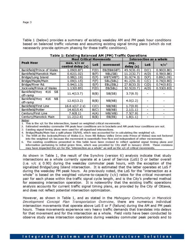
Transportation Overview prepared by Delcan to support the application,
indicates that 1,300 to 1,400 units could be approved subject to road network
improvements being in place in a timely manner and the related traffic assumptions
being realized. The Transportation
Overview indicates that there is not an acceptable or affordable transportation
solution for the full 1,800 units proposed for the Mahogany Community. Staff are recommending that the Development
Concept Plan provide for 1,400 units.
Phases 6 and 7 of the development, which would take the total beyond
1,400 units, should be frozen and the lands redesignated as Future Development
Area in the Secondary Plan. Development
of phases 6 and 7 will be beyond 2021, the time horizon of the Official Plan,
and an Official Plan amendment will be required at some point in the future to
allow development on these lands. At
that time, it must be demonstrated that there is capacity in the road network
in Manotick to accommodate more development.
b) Pace of growth
The
Secondary Plan provides for 2,000 dwelling units to the year 2020 in the
Village as a whole. Currently there are
1,750 dwelling units in Manotick leaving potential for 250 additional dwelling
units to the year 2020.
The
pace of growth should be tied to the provision of infrastructure rather than
arbitrarily constraining growth to a number of units by a specific date. Staff is recommending that a phasing plan
for the development be added to the Secondary Plan. The phasing plan prescibes the trigger mechanisms, indicating the
infrastructure required to be in place for each phase before it can proceed. If
the infrastructure projects are delayed, development will be delayed. Subdivision approval will be conditional on
detailed traffic studies confirming that there is infrastructure capacity for
each phase of development.
c) Provincial and Official Plan Policies/ Need
for the Development
Development
of these lands has been anticipated for a long time. The lands have been within the
village boundary since 1992, and the 2001 Secondary Plan provides
policies for development of these lands.
Village development conforms with Provincial and Official Plan policies.
2.
Transportation
Minto’s Initial Proposal
A
Transportation Overview report, prepared by Delcan for Minto, was drafted as a
supporting document to the DCP. The
Overview indicates that the transportation system in Manotick is currently at
capacity and transportation system improvements will be required for additional
development to proceed. The overview
concluded "with a reasonable degree of confidence that the peak-hour
traffic generated by 1300 to 1400 units in the Mahogany Community can be
adequately accommodated". There is
no identified solution at this time to allow for additional development. The limitation of the number of homes is
based on the capacity of the future regional transportation network and local
modifications.
One
of the significant improvements mentioned in the Transportation Overview is the
requirement for the Strandherd/Armstrong Bridge. The Overview projects that the Strandherd/Armstrong Bridge will
result in a 25 per cent reduction of peak-hour traffic on Bridge Street, which
equates to approximately 500 vehicles per hour. The redistribution of this traffic is key to accomodating the
future transportation demands for the Mahogany Community and all of
Manotick. The Overview report also
states that subdivision approval should be conditional on detailed traffic
studies confirming there is infrastructure capacity.
The
report indicated that there would be a need for further, more detailed studies
to support each phase of development.
The partial list includes:
- a before and after study of the impact of
the Strandherd/Armstrong Bridge on Bridge Street traffic volumes
- a study of the
feasibility/desirability of prohibiting heavy truck traffic from traveling on Bridge Street
- City action on the recommendations of the Bridge
Street Intersection and Access Review Study (Delcan 2006)
- a traffic
operations study of the Bridge Street and Main Street corridors to assess the merits of a one-way pair
scenario and/or other intersection modifications and traffic operational
issues. Possible options could
include: providing additional
lanes at the Manotick Main/Bridge Street intersection; closing the west
leg (Maple Street) of the Manotick Main/Bridge Street intersection; and
providing a one-lane roundabout at the Manotick Main/Bridge Street
intersection; and
- a parking study of
the core area to ensure a
sufficient supply of parking that is easily accessible given the likely
increased traffic flow on core area streets.
Subsequent
to the October 30, 2007 community meeting, Minto submitted an analysis prepared
by Delcan indicating that they feel that a portion of Phase 1 could be
accomodated without the construction of the Strandherd/Armstrong Bridge.
Community Concerns
Traffic
in Manotick is a major concern of the
community. Concerns expressed during
the various public consultation activities and submissions to the City included
the following:
- The Transportation
Overview prepared by Delcan for Minto is neither adequate nor
credible. The Strandherd/Armstrong
Bridge will not alleviate traffic congestion;
- Main arteries are
already clogged; area traffic
lights, pedestrian walkways/crosswalks should be included in the
recommendations; a comprehensive
approach is needed to address the (current and potential future)
transportation problem;
- The infrastructure
should be in place before development is approved;
- The development
will impact emergency response for police, fire, and paramedic.
Staff Response
a)
Peer Review
The
City retained National Capital Engineering/GENIVAR to undertake a peer review of the Transportation Overview. The peer review acknowledges that capacity
issues currently exist in Manotick and for this development to proceed,
significant regional infrastructure such as the Strandherd/Armstrong Bridge
will have to be in place. National
Capital Engineering/GENIVAR's recommendation to the City is to accept the
limitations of the development to 1300 to 1400 units and follow the suggested
monitoring and more detailed studies as listed in Section 7 of the Overview
Report. The detailed studies were
previously listed above under 'Minto’s Initial Proposal' heading.
b) New Policies for Phasing of Development
Building
upon the Overview and Peer Review conclusions, the level of development and the
phasing of the Mahogany Community will
be dependent on the provision of local and regional transportation
infrastructure. The Transportation
Overview has projected that additional capacity will be created in the future
to support the development. The
developer must demonstrate this capacity exists and mechanisms to achieve the
City's approved level of service operating standard. The release of phases and dwelling units is dependent on the
demonstration of capacity to support it.
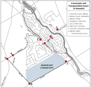
Manotick has unique geographic and transportation
constraints that are reflected by the following points and illustrated below on
the map of the village:
- Intersection
capacity of Manotick Main/Bridge, Rideau Valley/Bankfield, Bridge Street
and River Road
- Truck traffic on
Bridge Street
- New signalization
at Bankfield Road/Manotick Main
- The offset
intersection on Bridge Street which results in uncoordinated signals which
in turn result in less capacity
- There should also
be some indication of the amount of traffic heading along Bankfield Road
over to First Line Road, the jog at First Line Road (which is a problem)
and the traffic along Prince of Wales Drive
- Operational
limitations at First Line/Bankfield roads and the jog at First
Line/Bankfield.
Based
on the above, the total amount of development in Phases 1 to 5 as shown on
Schedule C to the Amendment, shall not exceed 1400 dwelling units to be phased
in accordance with the following phasing policies:
Phase
1
Zoning
amendments to permit the development in Phase 1 must be supported by traffic
impact studies to indicate that capacity exists in the village to support the
development, and how the constraints listed above have been alleviated. In Phase 1, the traffic study will include a
before and after study of the impact on the Strandherd/Armstrong Bridge. However, if the developer wishes to proceed
with a portion of Phase 1 without the implementation of the
Strandherd/Armstrong Bridge, the developer must demonstrate that the capacity
is in place. Currently there is no
evidence that this is the case.
Depending
on the timing of development (particularly related to the Bridge), the traffic
impact study may include:
- Feasibility/desirability
of prohibiting heavy truck traffic on Bridge Street
- Action on access to
the south island as per Bridge Street Intersection and Access Review Study
(Delcan 2006)
- A traffic
operations study of the Bridge Street and Main Street corridors
- A parking study of
the core
Phases
2 to 5
Like
Phase 1, the development of Phases 2 to 5 depends on the timing of
Strandherd/Armstrong Bridge and its impact on the transportation network. The zoning amendments for each phase(s) of
development will be supported by traffic impact studies which include the
following:
- A traffic impact
study which must include a wider network reaching northward to the future
intersections on each side of the Strandherd-Armstrong Bridge.
- Field survey and
verification of the actual intersection capacity and operation in the
field
- Comments regarding
the southeast and southwest sector transportation network
development. Issues related to the
Southwest Transitway, North-South Light Rail and major roadway
modifications such as Limebank Road and Prince of Wales Drive need to be
monitored with identification of actual infrastructure timing as part of
the justification for all significant development in this area of the
City.
- Depending on the
timeframe of each phase, it shall be the responsibility of Minto to fund
or wait for City implementation of the following local modifications
(subject to change depending on the results of the required studies and
verifications):
- A wider analysis
network reaching northward to the future intersections on each side of
the Strandherd-Armstrong Bridge
- signalization of
the Bankfield Road/First Line Road intersection and provision of the
required turn lanes
- potential
modifications to the Bankfield Road/Prince of Wales Drive intersection
(if warranted)
- additional turn
lane and approach lanes, as identified/required at both the Bankfield
Road/First Line Road and Bankfield Road/Prince of Wales Drive intersections
- Consideration of
the need to connect the East-West Collector to First Line Road in order
to minimize the site traffic impact on Manotick Main Street
- Pedestrian
connection to Potter Drive
- East-West
Collector Road link to First Line Road, if not provided/required at Phase
3
c)
Emergency Response
Police,
Fire and Paramedic Services have indicated that they do not see a significant
concern for public safety, nor would the proposed development cause concerns
for emergency response.
3.
Location of Multiple Units
Minto’s Initial Proposal:
Minto
proposed that 25 per cent of the housing stock in the Serviced Development Area
be multiple units.
a) Currently multiple family housing is
directed to the Village Core. Section
3.7.2.3.c) 3. of the Secondary Plan
states:
"Ensure
that the Village’s housing stock continues to consist primarily of single
family, detached housing, while allowing for a limited range of multiple family
housing which shall locate in the Village Core".
Minto
has proposed that the policy be amended by adding the following phrase to the
end of the policy.
“and
up to 25% of the housing units in the Serviced Development Area.”
b) Section 3.7.2.5 (2) (a) says:
"Residential
development outside the Village Core shall be located in areas designated
Single Family Estate; Single Family (Low Density); and Single Family (Moderate
Density)" as indicated on Schedule A.
Minto
proposes adding a designation "Multiple Residential" to allow for a
mix of housing types in the Serviced Development Area.
Community Concerns
- Multiple units
should be directed to the village core as required by Secondary Plan;
- There are too many
multiples - this will result in a suburban Barrhaven type of development
that is not appropriate in a village.
Staff Response
a) Village Core
Since there is little vacant land in
the village core (3.24 hectares), there is very limited potential for the type
of multi-unit development proposed in the Mahogany Community which include
semis, linked bungalows, small singles and townhomes. When central services are provided to the core, there will be
potential for redevelopment in the form of apartments and mixed-use
development. The type of multiple unit
development proposed in the Mahogany Community should not compete with the
redevelopment that will occur in the village core, therefore it will not
compromise the Plan's objectives for the core.
b) Opportunity to Provide a Range of
Housing Opportunties
The DCP provides for a mix of
housing units in the Mahogany Community where up to 25 per cent of the Mahogany
Community will be semis, linked bungalows, small singles and townhomes. Villages such as Manotick, that have public
services, provide unique opportunities in the rural area to provide a range of
housing units because the servicing is not a constraint. A range of housing units is a benefit to
meet the needs of all age groups, including young people starting out and
seniors who want to down size but stay in the village. Villages with services such Carp, Richmond
and Greely (with communal services for some developments) are examples of
villages that provide for multiple unit development.
c) Location of Multiples
The initial land use plan proposed
by Minto showed large blocks reserved for multi-unit development for Mahogany
Community. Large blocks of multiple
unit development is typical in most suburban developments but is not typically
found in villages. The DCP has been
revised to locate Mixed Residential areas
(which includes semis, linked bungalows, small singles and townhomes) in
neighbourhood cells throughout the Mahogany Community so that the multiple
units will be integrated into the community rather than stand alone in large
blocks. The densities of Mixed
Residential will not exceed 35 units per gross ha (14 units per gross
acre). The architectural guidelines in
the DCP set criteria for maximum consecutive housing types or maximum
percentages to ensure that the development is compatible with the village.
4. Density of Housing
Minto’s Initial Proposal
Minto proposed that Section 3.7.2.5
policy 2 c) be amended to increase the density for Single Family (Moderate
Density) areas from a density of four to six units per gross residential acre
to four to seven units per gross residental hectare. As proposed in the concept plan, single family residential
provides for lot sizes from 12.2 metres x 32 metres (390 square metres) to 18 metres x 32 metres (576 square
metres).
Community Concerns
- The development proposed is too dense and
is similar to an urban standard, not a village standard;
- Small lots are not appropriate in the
village - maintain the standard of
0.2 hectares (half acre ) lots in the village.
Staff Response
Where services are available, in
serviced villages such as Carp, Richmond, Greely, larger lots of 0.2 hetares
(half acre) are not required to be provided for septic fields so development
standards in these villages are smaller lots to make a more efficient use of
infrastructure and land.
Manotick has developed over many
years and there is a range of lot sizes in parts of the village, 0.2 hectares
is not the standard.
|
Neighbourhood |
Metric |
Imperial |
|
Manotick
village core |
15
m x 32 m = 480 sq m |
50
ft x 100 ft = 5,000 sq ft |
|
Hillside
Gardens |
22
m x 32 m = 704 sq m |
72
ft x 100 ft = 7,200 sq ft |
|
Manotick
Estates |
32
m x 69 m = 2,200 sq m |
105
ft x 225 ft = 23,700 sq ft |
Minto initially proposed a range of
frontages for single-family residential areas ranging from 12.2 metres to 18
metres. There is no precedent in the City for village development on 12.2‑metre
frontages. However 12.2‑metre
frontage for singles is appropriate if mixed with multiple units. The small lot singles should be included as
part of the up to 25 per cent of multiple-unit development which includes
semis, linked bungalows, and townhomes.
It is not appropriate to amend the
Single Family (Moderate Density) designation as this designation applies to
areas throughout the village. The
Secondary Plan is being amended to add three designations that will apply only
to the Mahogany Community as shown on Schedule B of the amendment.
- Single Family (Low Density) with an
approximate lot size of 22 metres x 50 metre
- Single Family (Moderate Density) with a
range of frontages from 13.5 metres to 18 metres and a lot depth of
32 metres which may have a density of up to seven units per gross
residential acre (up to 16 units per gross residential hectare)
- Mixed Residential Area which may have a
density of up to 14 units per per gross residential acre (up to 35 units
per gross residential hectare).
The Mixed Residental Area will provide for a mix of units;
including semis, link bungalows, townhomes and small lot singles (12.2 m
frontages).
5.
Village Character
Minto’s Initial Proposal
The
initial Development Concept Plan provided for:
- Development to be phased according to the
provision of infrastructure to the village;
- A range of housing units to meet the needs
of community;
- Natural Features to be preserved and
integrated into the development;
- A parks and open space system linked to
the village;
- A spine road to be built through the
centre of the community which will be designed as a rural lane to separate
and balance the size of the neighbourhoods. Homes in the adjacent neighbourhoods will back on to the spine
road and the sidewalks will be located inside a boulevard of trees;
- A gradual transition of uses to
surrounding neighbourhoods.
Community Concerns
- Design uniformity will drive down property
values;
- The plan should provide for a variety of
housing types with different sizes and looks, similar to what exists in
the village now;
- Preserve quality of life. The amount of traffic, amount of
development, density, unit type are concerns;
- There should be a transition from existing
development by providing buffering with tree screens to reflect historic
roots.
Staff Response
a)
Village character
Concerns related to traffic, amount
of development, density, unit type and how they affect village character have
been discussed previously. The
guidelines are included as part of the DCP and will provide a framework for how
the community will develop in a way that is compatible with the existing
community in Manotick.
At the request of the City, Minto
has provided architectural and design guidelines to ensure that new development
is consistent with village character.
The
design guidelines provide for:
- green entrances to neighbourhoods;
- streets with 'T' intersections, providing
views to woodlots and stream corrodors;
- tree planting and landscaping.
The architectural guidelines provide
for:
- generous sideyard setbacks - 2.0-metre
minimum and 4.0 metre minimum for corner lots;
- architectural variety;
- cladding materials and colours to be used;
- mixing of house types and styles by
setting maximum consecutive housing types or maximum percentages.
b)
Transition
The DCP provides for a gradual
transition from exising development in Manotick Estates by providing for larger
lots (22 metre x 50 metre) and buffering.
Buffering will also be required for the existing development on Manotick
Main Street.
6. Community Facilities
Minto’s Initial Proposal
The parks and open space system
connects to the rest of the village.
Two schools sites have been requested by the school boards.
Community Concerns
- Increased development will result in
decreased accessibility to recreational facilities – community sports
programs, library and social resources.
Staff Response
The DCP provides an open space system that includes parks, pathway systems and schools
to address the needs of the new community.
The provision of indoor recreational facilities will be
guided by Parks and Recreation's Community Infrastructure Strategy and Project
Listing. A large complex, strategically
located just north of Manotick and south of Barrhaven, is planned to service
the indoor recreational needs (twin pad arena, pool and full service community
centre) of new residents in Manotick and the new south Barrhaven area.
7.
Servicing and Provision of Infrastructure
Minto’s Initial Proposal
Minto proposes to develop the
community on central services as required by the Secondary Plan. Minto has prepared and submitted a servicing
plan.
Community Concerns
- There is no need to bring sewers to
Manotick – well and septic or alternative servicing options are better
solutions;
- Residents are concerned that they will be
forced to pay to hook up to services they do not need;
- Central services could potentially leak
into the groundwater and impact on existing wells.
Staff Response
The Manotick Secondary Plan requires
the development to be on central services.
The City implements alternative services where studies demonstrate that
those services are the best solution.
This was recently done at the Carp Airport and in the Shadow Ridge
subdivision in Greely. The 1997
Servicing Options Study and Environmental Assessment concluded that central
services were the best servicing solution for Manotick. The Study evaluated a comprehensive range
of options for water and sewer services including: a new treatment plant to be
located in Manotick with discharge into the Rideau River and small bore and
other alternative effluent collection technologies among many others, a series
of communal sewage treatment facilities that would discharge into large tile fields,
and a central sewage pumping station connected via forcemain to the West Rideau
Collector. The Manotick Secondary Plan
implements the findings of the Servicing Options Study and requires new
development to be on the basis of central services.
The developer is responsible for
paying its portion of the costs for servicing the new development. For other residential areas, connections
will only be required where a community/neighbourhood requests connection through
a Local Improvement Area petition. A Local
Improvement Area petition to support the costs requires 67 per cent of the
properties representing 50 per cent of the total assessed value to vote in
favour.
The Preliminary Groundwater
Assessment that was prepared by Paterson Group Inc. indicates that it is
unlikely that there are groundwater discharge areas present in the subject
area. This is consistent with the overburden thickness of the surficial soils
and relatively shallow depth of Mud Creek.
Any impacts on existing wells from the temporary or permanent dewatering
of the perched groundwater at the Subject Area, resulting from the installation
of municipal services, is likely to be negligible. A pre-development survey of wells will be required and a monitoring
program and contingency plans prepared at the time of development.
Development
Charges
The City calculates residential
development charges on a large area basis.
Currently three area-specific charges are used to differentiate the
costs of servicing residential development:
Inside the Greenbelt, Outside the Greenbelt, and Rural. Under the current calculation methodology,
the proposed Mahogany Community is located within the Rural residential
development charge zone. During the
City's upcoming development charge study process, consideration will be given
to various options that reflect the additional growth-related servicing costs
to be recovered from this new subdivision and its proximity to the current
Outside the Greenbelt boundary.
8. Natural Environment and Parks
Minto’s Initial Proposal
The Minto proposal protected the
candidate Area of Natural and Scientific Interest (ANSI), but for the remainder
of NESS 506, part was proposed to be reserved as a community park and part was
proposed to be developed as residential.
Stream setbacks for Mud Creek are
proposed to be increased to 50 metres (as opposed to 30 metres required in
the Secondary Plan).
The pond on the property is proposed
to be reserved as park land.
Community Concerns
The community wants the woodlot and
the pond to be protected from development.
Staff Response
Protection of the Woodlot:
The Natural Resource Existing
Conditions Report prepared by EcoTec Environmental Consultants for Minto to
support the DCP, concluded that NESS 506, including the Manotick Drumlin
Forest and excluding Community 6,
should be retained. The Province also identified the Manotick Drumlin Forest as
a candidate provincially-significant Area of Natural and Scientific Interest in
1995. In 1997 the former Region of
Ottawa-Carleton also considered the area through the Natural Environment
Systems Strategy and scored it of “moderate” significance on the City-wide
scale. Based on these evaluations, City
staff has concluded that this area is a
“significant woodland” under the Provincial Policy Statement (PPS). The PPS states that development and site
alteration shall not be permitted in significant woodlands south and east of
the Canadian Shield unless it has been demonstrated that there will be no
negative impacts on the natural features or their ecological functions.
The City wants to keep this parcel
in an undeveloped state in accordance with the EcoTec Report. If the property
is to be treated in a similar manner as other lands where the City does not
support any development, the appropriate designation is Natural Environment
Area. Once the parcel is designated
Natural Environment Area, the landowner may request the City to acquire it, and
in accordance with the Official Plan, the City will acquire the land. The City may also consider other methods to
achieve the objective such as negotiating a conservation easement. If public acquisition of the land cannot be
negotiated as described in the sequence below, the land will be redesignated as
Rural Natural Feature or as another designation that meets the tests of the
Provincial Policy Statement.
The Development Concept Plan
therefore proposes that:
- The site be designated Natural Environment
Area in the Official Plan and Manotick Secondary Plan, and be subject to
all of the policies of Sections 3.2.2 and 5.2.1 of the Official Plan
including the need for an EIS within 30 metres of the boundary of the
Natural Environment Area;
- The City and Minto enter into negotiations
for the City to secure the property and retain it in its natural state;
- By 2011, if the City and Minto have not
reached agreement on securing the property, ·the developer will complete
an EIS of development within NESS 506 to demonstrate that development
could occur and still meet the test of the PPS. The City will amend the Manotick Secondary Plan to change
the designation of the Natural Environment Area, based on the outcome of
the Environmental Impact Study.
- Any development potential arising from the
approval of an EIS would be added to the “Future Development Area” as
there is no capacity for it in Phases 1 to 5.
The Pond:
While it is not provincially
significant, the pond in the southeast portion of the Mahogany Community
provides habitat for amphibians with potentially suitable breeding habitat for
toad and/or frog species such as the wood frog, green frog, leopard frog, gray
tree frog, and the spring peeper. It
may not be capable of supporting these species year-round, due to shallow water
levels. The pond collects local surface
water and shallow subsurface infiltration from a small (six hetares) catchment
area, with water levels being maintained by the relatively impermeable
subsoil. Reduction of the catchment
area will likely result in the pond becoming a seasonally wet feature, which
will limit its use by some species.
A small area of natural greenspace
will be retained around the pond as a neighbourhood amenity and seasonal
wildlife habitat (and will not be included in the 5 per cent parkland
dedication). The permitted uses in this
land use category include trails and pathways. The location and design of any
trails or pathways will need to be approved by the City and the Rideau Valley
Conservation Authority.
9. School Sites
Minto’s Initial Proposal
The English Public and Catholic
School Boards have requested that school sites be reserved in the Mahogany
Community. The DCP provides for two
school sites.
School Board Comments
The Ottawa Catholic School Board has
requested the elementary school site be relocated to the north into Phase 5,
adjacent to the neighbourhood park. The
relocation is necessary due to timing of development, as well as traffic,
design and safety issues related to Century Road.
Staff Response
The school site has been relocated
into Phase 5 on the Rural Lane/Spine Road, closer to a neighbourhood park.
10. Road Access - Connections to Carrison Drive and Potter Drive
Minto’s Initial Proposal
Minto proposed that there be roadway
connections to Carrison and Potter Drives to provide a link from Mahongany
Community to Manotick Estates.
Community Concerns
- Creating the link to the Estates will
encourage cut-through traffic to access Bankfield Road and/or the village
core;
- The streets in Manotick Estates were not
designed for additional traffic, and the lack of sidewalks is a safety
concern.
Staff Response
The connections to Carrison and
Potter Drives will provide for pedestrian and cycling links and not for
traffic.
B.
THE DEVELOPMENT CONCEPT PLAN AND CONSISTENCY WITH THE MANOTICK SECONDARY
PLAN
The Development Concept Plan, as
revised, is consistent with the objectives in the Manotick Secondary Plan as
demonstrated in the following table.
|
Secondary
Plan Section 3.7.2.2 |
How
the DCP is consistent with the objectives |
|
Primary Objectives |
|
|
1. To preserve and maintain the quality and
character of life enjoyed by the people who live or work in Manotick |
Development
phasing is tied to provision of infrastructure. Natural
features are preserved and incorporated into the village. The
parks and open space system is linked to the rest of the village. The
range of housing units is provided to meet the needs the of community. |
|
Secondary Objectives |
|
|
1. To have regard to Federal, Provincial
policies inasmuch as they apply to a Village; |
DCP
is consistent with Provincial Policy Statement:
|
|
2. To provide policies to conform with the
Ottawa Official Plan |
Conforms
with Official Plan policies:
|
|
3. To provide for the periodic review of
this Plan and its performance not less frequently than each five (5) years
and to take action as deemed appropriate where the Plan’s performance is
proceeding in a manner which is not consistent with the Primary Objective; |
The
indicators listed in Secondary Plan are:
The
five-year review has not been completed, however the background studies
completed to support the DCP, provide updated information on the indicators
as required by the performance review.
This provides the information base for decision-making that is
required by the Plan. |
|
4. To conserve Manotick’s natural resources
and to encourage their preservation; |
The
land-use plan preserves the significant woodlots, stream corridors and the
pond. |
|
5. To provide for the preservation and/or
acquisition of the Rideau River shoreline and its availability for public
enjoyment; |
N/A -
Mahogany Community does not have frontage on the Rideau River. |
|
6. To conserve and enhance Manotick’s
heritage resources and the Village’s identity and character as an historic
town on the Rideau Canal National Historic Site, a Canadian Heritage River; |
Architectural
and design guidelines are provided to ensure future development is compatible
with village character. |
|
7. To protect and enhance the environmental
quality of the Rideau Canal (River), a Canadian Heritage River, by
encouraging shore land property owners to naturalize their shore lands in the
interests of improving water quality and to re-establish the natural
appearance of the Rideau Canal shore land; |
N/A -
Mahogany Community does not have frontage on the Rideau River. |
|
8. To provide a strategy for the provision
of infrastructure to Manotick; |
The
Secondary Plan requires central sewer and water services. A Master Servicibility Study is provided
to implement this. |
|
9. To provide safe, convenient and pleasant
pedestrian and cycling routes throughout the Village; |
Pedestrian
and cycling links are provided throughout the community that connect to the
village. |
|
10. To ensure compatibility of any new
development or redevelopment with the existing community and its established
character in terms of the type, scale and built form of the new development
or redevelopment; |
Larger
lots and buffers are provided adjacent to existing communities. Architectural
and design guidelines are provided to ensure future development is compatible
with village character. |
|
11. To protect and enhance the commercial
functions of the Village core; |
No
commercial development is proposed in the Mahogany Community – commercial
uses are directed to the village core.
The additional development will support the village core. |
|
12. To provide adequate opportunity for jobs
and housing in the overall community in a manner that is desirable for a
Village and consistent with the community’s Vision; |
A
mix of housing units is provided throughout Mahogany Community. |
|
13. To provide recreation and leisure
facilities that are conveniently located and accessible to all residents; |
The
land-use plan provides for a parks and open space network that connects to
the rest of the village. |
|
14. To provide for an orderly growth and
development strategy within the Village; and, |
Development
will occur in phases and will depend on the provision of infrastructure. |
|
15. To provide an adequate mix of housing in
the Village as a whole as opposed to any one residential neighbourhood or new
development area. |
A
mix of housing units is provided – up to 25 per cent of the Mahogany
Community will be semis, linked bungalows, small singles and townhomes. |
Document
4, the Background Report, was prepared
by Minto in support of the DCP and is provided for information and is a summary
of the contextual, historical, transportation and environmental
information for the DCP.
OFFICIAL PLAN AMENDMENT
While the DCP is consistent with the
primary and secondary objectives of the Secondary Plan, the proposed
development deviates from some of the policies in the Secondary Plan. As a result an Official Plan amendment is
required to implement the DCP. The
Official Plan amendment proposes to amend policies related to:
- village growth including the pace of
growth and phasing policies,
- the identification of a Future Development
Area,
- housing density and the location of
multiple units,
- the land use designationas on Schedule A.,
- the protection of the natural areas - the
significant woodlot and the pond.
All of these issues have been
discussed in the Analysis and are summarized below.
1.
Village Growth
Section 3.7.2.3 of the Secondary
Plan states “Allow the area of the village to be serviced on central services
to gradually grow to accommodate 2000 housing units and up to 2000 jobs by the
year 2020 guided by the growth management policies of this plan.” This policy is being amended to tie the pace
of growth to the provision of infrastructure.
In particular, the developer will be required to demonstrate that
transportation capacity exists and mechanisms are in place to maintain the
City's approved level of service operating standard prior to the approval of
zoning to support development.
2.
Future Development Area
Since there is no transportation
infrastructure identified to support the development in Phases 6 and 7, these
phases will be designated as 'Future Development Area' . An Official Plan Amendment supported by the
necessary studies, including transportation, will be required to allow
development on these lands.
3.
Density and Type of Units
The Secondary Plan is being amended
to allow for a mix of housing units to be permitted in the Mahogany Community
to include multiple units (semis, linked bungalows, small singles and town
homes). However, the multiple units
will be required to blend into the neighbourhoods and not be in large
concentrations.
4.
Serviced Development Area Development Plan
The Secondary Plan required the
preparation of a Development Concept Plan.
Now that this has been completed, the requirement will be removed.
5.
Schedule B
Schedule B has been added to the
Secondary Plan to provide a detailed land use plan for the Mahogany
Community. The conceptual designations
on Schedule A for these lands have been replaced with a reference to "See Schedule B". Schedule B for the Magohany Community is
based on the detailed studies and it implements the land use plan in the
DCP. The plan provides for:
- three residential designations:
- Single Family (Low Density) - transition
to similar size lots in Manotick
Estates;
- Single Family (Moderate Density) -
development of singles at slightly higher density than anticiapted in the
Secondary Plan - the Single Family (Moderate Density) designation in the
Secondary Plan provides for a density of four to six units per gross
residential hectare - the new designation provides for a density of four
to seven units per gross residential hectare;
- Mixed Residential - semis, linked
bungalows, small singles and townhomes to be located within neighbourhood
cells within Mahogany Community.
- the significant woodlot, all of NESS 506
is designated as a Natural Environment Area based on the Natural Resource
Existing Conditions Report that was done to support the DCP - the current
Secondary Plan only protects part of the woodlot at the southern part of
the property, the candidate ANSI,
which is shown conceptually;
- the pond near Manotick Main Street - a
small area of natural greenspace will be retained around the pond as a
neighbourhood amenity and seasonal wildlife habitat - the pond is not
protected in the current Secondary Plan;
- the east-west local road provides a
connection to First Line Road through the Mahogany Community - the current
Secondary Plan shows the link through Manotick Estates which is not
feasible;
- locations for schools and park sites -
shown as symbols in the current plan;
- more precise watercourse and development
setbacks - the required setback for Mud Creek is 50 metres - only 30
metres is required by the current Secondary Plan;
- locations for stormwater management ponds
to service the community - not shown on the current Secondary Plan;
- a Future Development Area designation for
the lands in Phases 6 and 7 where there is no transportation
infrastructure identified to support the development.
6.
Village Environmental Management
The Secondary Plan is being
amended to add policies to protect the Natural Environment Area designated on
Schedule B. It is the intention of the
Plan that the City secure these lands to preserve them for the community.
7.
Village Open Space and Recreational Areas Policies
In association with Schedule B, the
policy is being revised to indicate that “Lands identified on Schedule B to
this Amendment shall be retained as Natural Environment Area.”
A new policy is being added to
Section 3.7.2.8 (2) (e) to protect the Pond - a small area of natural
greenspace around the pond in the south-east portion of the Mahogany Community,
as a neighbourhood amenity and seasonal wildlife habitat. The permitted uses in this land-use category
include trails and pathways. The location and design of any trails or pathways
must be approved by the City and the Rideau Valley Conservation Authority.
8.
Definition of Gross Residential Hectare
The definion of Gross Residential
Hectare in Section 3.7.2.5 policy 2 e)
includes "Significant Woodlot".
The term "Significant Woodlot" in the Secondary Plan is being
replaced by "Natural Environment Area".
The proposed Official Plan Amendment
is attached as Document 1 to this report.
CONCLUSIONS
Staff are recommending that the Official Plan Amendment to the Manotick Secondary Plan and the Development Concept Plan for the Mahogany Community be approved. Key points:
- The plan should provide for 1400 units based on the capacity of the future regional and local road networks;
- A phasing plan is being added to the Secondary Plan to tie future development to the provision of infrastructure. The developer will be required to submit detailed traffic impact studies for each phase to demonstrate that capacity exists to support the development and the mechanisms to achieve the City’s approved level of service operating standard;
- The plan will provide for up to 25 per cent of the Mahogany Community to be multiple units (small lot singles, semis, linked bungalows, townhomes) to be integrated into neighbourhoods;
- Architectural and design guidelines have been prepared to ensure that the new development is consistent with village character;
- The significant woodlot will be protected as a Natural Environment Area and will subject to the land acquisition policies in the Official Plan;
- The pond will be protected as a Neighbourhood Amenity;
- Provision of pedestrian/cycling connections to Carrison Drive and Potter Drive;
- Provision of parks, open space, recreational pathways, stream corridors, stormwater ponds and schools.
ENVIRONMENTAL IMPLICATIONS
The significant woodlot - NESS 506 and the Candidate ANSI are preserved as natural areas.
Stream setbacks of 30 metres are required for all streams except for Mud Creek where a 50‑metre setback is required as recommended by the Natural Resource Impact Report submitted to support the development.
The street pattern for Mahogany Community will be a modified grid maximizing east-west streets, which facilitates solar access for new housing.
OC Transpo has commented that the mix of housing types contributes to a more transit-oriented community. The additional population, resulting from this proposal, will contribute to improved levels of transit service for the remainder of the community.
RURAL IMPLICATIONS
This
report relates to a Secondary Plan for a village in the rural area. The development of the Mahogany Community
will be on the basis of central sewer and water as required by the Manotick
Secondary Plan. Central servicing provides
an opportinity to provide for a range of housing opportinities which will
benefit the whole community, especially young families starting out and seniors
who wish to downsize and stay in the community. Emphasis has been placed on complementary village character in
the design of development in the area.
CONSULTATION
During the preparation of the DCP Minto held six meeting with community leaders to obtain input and to review the work as it progress on the plan. The community leaders included representatives from A.Y. Jackson Park Group, Councillor Brook's office, City of Ottawa, First Line Community Association, Kiwanis Club of Manotick, Knox Presbyterian Church, Manotick Action Group, Manotick Art Association, Manotick Business Improvement Area, Manotick Classic Boat Club, Manotick Community Association, Manotick Secondary Plan Committee, Ottawa Forest and Greenspace Advisory Committee, Ottawa South United Soccer Association, Rideau Senior's Centre, Rideau Township Historical Society, Rural Pathways Project, St James Anglican Church, St. Leonard's Catholic Church, Watson's Mill, West Manotick Community Association, and other public members at large.
Two meetings were held with landowners who owned property within the study area (the area designated Serviced Development Area in the Secondary Plan).
One meeting was held with the Manotick Parks Needs Working Committee to discuss parks and recreation for the Mahogany Community and the village as a whole.
There were a number of opportunities where the public had a chance to provide input/comments.
Public
Meeting and Open House - March 3, 2007 - Manotick Arena
·
Minto presented exisiting conditions and three concepts
for review and discussion
Community
Meeting - June 27, 2007 - St Mark's
High School
·
Minto presented proposed Official Plan Amendment and
DCP
Technical
Circulation - July 24, 2007
·
The Official Plan Amendment and DCP were circulated to
affected parties (community associations and property owners within 120 metres)
for comments
Community
Meeting - October 30, 2007 - Tudor Hall
·
staff presented the City's initial reations to the
Minto’s initial proposal
Ottawa Forests and Greenspace Advisory
Committee (OFGAC) Meeting - November 26, 2007
·
Minto presented their response to the City's initial
reactions
·
the Community was invited to provide comments
Rural
Issues Advisory Committee (RIAC) Meeting - November 27, 2007 - Nepean
Sportsplex
·
Minto presented their response to the City's initial
reactions
·
the West Manotick Community Association presented their
concerns regarding the proposed development
·
the Community was invited to provide comments
Notice
of this application was carried out in accordance with the City's Public
Notification and Consultation Policy. The Councillors are aware of this
application and the staff recommendation.
The City has received more than 200 letters/e-mails from members of the
community who are opposed to the Mahogany Community proposal and the amendment
to the Manotick Secondary Plan that is required to implement the DCP.
The responses to the circulation provided by OFGAC and the West Manotick Community Association, the public, Brian Miller and Mike O'Neil (Manotick Community Association are provided in Document 3.
FINANCIAL IMPLICATIONS
Minto Developments will be required to pay for the cost of extending sewer and water services to the Mahogany Community and the emplacement of local servicing components through the subdivision process. The capital cost of stormwater management facilities will be recovered through an area-specific charge applied against the benefiting area. Other growth-related infrastructure capital costs, such as roads associated with this specific geographical area, will be reviewed and several methods will be considered for the recovery of servicing costs. The new detailed infrastructure cost requirements for roads will be identified in the Transportation Master Plan (Section 2.3), and in the Master Servicing Plan (Section 2.4) for water and wastewater, of the DCP.
The significant woodlot is designated as Natural Environment Area. It is the intention of the Plan that the City acquires these lands to preserve them for the community subject to all of the policies of Section 3.2.2 and 5.2.1 of the Official Plan. Once the appropriate mechanism to secure the land is confirmed, the approach will be subject to Corporate Services and Economic Development Committee and City Council approval.
Future operating impacts will be born by the City but are currently unavailable at this time.
SUPPORTING DOCUMENTATION
Document 1 Official Plan Amendment _
Document 3 Comments received from the circulation
Document 4 Mahogany Harbour Background Report (issued separately and filed with the City Clerk)
DISPOSITION
The
Planning, Transit and the Environment Department will issue the Notice of
Decision within the 20-day appeal period for Amendment __.
OFFICIAL PLAN AMENDMENT DOCUMENT 1
|
|

Official Plan Amendment XX
Modification
du Plan directeur XX
To
the Official Plan for the City of Ottawa, Annex D, Volume 2C, Village Plans,
Manotick
INDEX PAGE
The Statement of Components
Part A - The Preamble
Purpose
Location
Basis
Part B - The Amendment
Introductory Statement
Details of the Amendment
Schedule A – Amendment to Village of
Manotick Land Use Plan - Schedule A
Schedule B –Land Use Concept Plan
for the Mahogany Community - Schedule B
Schedule C – Phasing for Mahogany
Community – Schedule C
STATEMENT OF COMPONENTS
PART A - THE PREAMBLE does not constitute part of this
amendment.
PART B - THE AMENDMENT, the following text and map
constitutes Amendment No. XX to the Official Plan for the City of
Ottawa, Annex D, Volume 2C, Village Plans, Manotick.
PART A - THE PREAMBLE
PURPOSE:
The
Village Plan for Manotick requires a comprehensive development concept plan for
lands designated “Serviced Development Area”. As a result, the Mahogany
Community Development Concept Plan (DCP) was prepared, which includes
supporting studies for the lands. In
order to implement the DCP, an amendment to the Manotick Secondary Plan is
required. The purpose of this amendment is to provide additional policies for
the area designated Serviced Development Area in the Village Plan for Manotick.
Specifically the Amendment does the following:
1. Revises Schedule A to the Secondary Plan for Manotick by replacing designations within the Serviced Development Area with a notation “See Schedule B”;
2. Adds Schedule B to the Secondary Plan – a land use plan for Mahogany Community
3. Adds Schedule C to the Secondary Plan – Phasing for Mahogany Community
4. Makes reference to the Mahogany Community Development Concept Plan that will be used for the basis of planning and development;
5. Revises the growth management policies so that the phasing of
development in Manotick is based on the provision of infrastructure rather than
a date in the plan. Provides phasing policies for the Mahogany Community that
are tied to infrastructure triggers;
6. Provides a new designation, Future Development Area, for lands where development will not be permitted until there is a transporation solution in place to accommodate development on these lands and an amendment is adopted by City Council;
7. Amends policy 2(g) of Section 3.7.2.5 “Housing in the Village”
policies, specifically to permit multiple residential units in the Mahogany
Community;
8. Provides additional policies to reflect village character, natural
environment areas, and stormwater management areas;
9. Amends policy 2(c)(i) of Section 3.7.2.8 “Village Open Space and
Recreational Areas” policy to reflect the lands designated “Natural Environment
Area” as per Schedule B to this Amendment; and
10. Amends policy 2(e) of Section 3.7.2.5 “Housing in the Village” to
include Natural Environment Areas in the definition of Gross Residential
Defined.
LOCATION:
The lands affected by this amendment are legally described as Part of Lots 4 and 5, Concession A (Broken Front) Geographic Township of North Gower, City of Ottawa. The property constitutes approximately 194 hectares within the Village of Manotick boundary. The property is bounded on the north by the existing residential area of Potter Drive, Watterson Street, and Carrison Drive; to the south by Century Road; to the east by Manotick Main Street; and to the west by First Line Road and Mud Creek.
BASIS:
The Council Approved Village Plan for Manotick designates the lands legally described as Part of Lots 4 and 5, Concession A (Broken Front) Geographic Township of North Gower City of Ottawa, as Serviced Development Area. The Village Plan requires a comprehensive development concept plan to be prepared for the entire area before development can occur that will facilitate the logical phasing of development in the area (the integration of transportation links, parks and open space, schools and pedestrian links and stormwater) and that will form the basis for various, subsequent plans of subdivision. All development shall be on the basis of central water and wastewater services. Following a thorough and comprehensive review, the Mahogany Community Development Concept Plan was prepared. It provides the basis for this amendment and proposes development that will utilize serviced lands more efficiently; provide a variety of housing for existing and future Village residents; provide linkages and connectivity; and protect natural features.
Permitting slightly higher density forms of development supports transit and makes efficient use of land, while still maintaining the village character. This amendment to the Official Plan for the City of Ottawa, Annex D, Volume 2C, Village Plans entitled “Manotick Official Plan Amendment #3 Former Township of Rideau” enables the future development of the Mahogany Community in the Village of Manotick.
This amendment is consistent with the 2005 Provincial Policy Statement and the Official Plan for the City of Ottawa and conforms to the objectives and principles of the Village Plan.
PART B - THE AMENDMENT
All of this
part of the document entitled Part B - The Amendment, consisting of the
following text and attached map, constitutes Amendment No. XX to the Official
Plan for the City of Ottawa, Annex D, Volume 2C, Village Plans, Manotick.
DETAILS OF THE AMENDMENT
The
Official Plan for the City of Ottawa, Annex D, Volume 2C, Village Plans,
Manotick entitled “Manotick Official Plan Amendment #3 Former Township of
Rideau” is hereby amended as follows:
ITEM 1: The area indicated on the attached Schedule A, is amended by replacing designations within the Serviced Development Area with a notation “See Schedule B”.
ITEM 2: A new Schedule B, Land Use Plan – Mahogany Community, is added to the Secondary Plan and forms part of this Amendment.
ITEM 3: A new Schedule C, Phasing Plan – Mahogany Community, is added to the Secondary Plan and forms part of this Amendment
ITEM 4: Policy C(1) of Section 3.7.2.3 Village Growth Management Policies, is amended by replacing the existing policy with the following:
1. Village Growth
The growth management policies will require that growth be carefully managed to ensure that the infrastructure is in place to support new development in the village. The development of the Mahogany Community as shown on Schedule B will be phased based on the provision of infrastructure as stated in policy 2(g) (vi) of Section 3.7.2.5.”
ITEM 5: Section 3.7.2.3 (C) is amended to by adding a new policy 5) as
follows:
"The lands designated Future
Development Area currently cannot be supported by any transportation
solution. Development of these lands
will be frozen until there is transportation solution to accomodate development
on these lands. A public process in the
form of an Official Plan amendment will be required to permit development. The amendment shall be supported by a
Traffic Impact Study to demonstrate that the road system in Manotick can
accomodate additional development."
ITEM 6: Policy
2(g) of Section 3.7.2.5, Serviced
Development Area Conditions, is amended by replacing the existing policy
with the following:
g) Mahogany Community Conditions
The lands designated on Schedule
B, Land Use Plan – Mahogany Community,
shall be developed in accordance with the following conditions:
i)
All development shall be on the basis of central water and
wastewater services;
ii)
A comprehensive Development Concept Plan as approved by the
City of Ottawa will be used as the basis for the approval of subsequent plans
of subdivision, site plans and zoning;
iii)
The location of land uses will be in accordance with Schedule
B;
iv)
Notwithstanding Policy C. 3) of Section 3.7.2.3, multiple
family housing will be permitted in the Mahogany Community as shown on Schedule
B;
v)
In addition to policies 2 a) to d) of Section 3.7.2.5 concerning
Residential Densities, the following additions will be permitted in the
Mahogany Community which is shown on Schedule B:
a.
Single Family (Low Density)will provide for approximate lot
sizes of 22 m x 50 m.
b.
Single Family (Moderate Density) areas may have a density up
to seven units per gross residential acre (i.e. up to 16 units per gross
residential hectare).
c.
Mixed Residential areas may have a density of up to 14 units
per gross residential acre (i.e. up to 35 units per gross residential hectare),
and consist of singles, street townhouses, semi-detached, linked bungalows,
terraced homes and multiple clusters provided no more than 25% of the total
residential units on the lands shown conceptually on Schedule B to this
Amendment are Mixed Residential.
Mixed Residential shall be integrated into the overall residential
development.
vi)
The level of development and the phasing of the Mahogany Community will be dependant on
the provision of local and regional transportation infrastructure. It has been projected that the
Strandherd/Armstrong Bridge will create additional capacity in the future to
support the development. The developer
will be required to demonstrate this capacity and how to achieve the City’s
approved level of service operating standard.
The release of phases and dwelling units is dependant on the
demonstration of capacity to support it.
The total amount of development in the Phases 1 to 5 as shown on Schedule C shall not exceed 1,400 dwelling units to be phased in accordance with the following phasing policies:
Phase 1
Detailed traffic impact studies,
including a before and after study of the impact on the Strandherd/Armstrong
Bridge, will be required to demonstrate there is capacity in Manotick to
accommodate the development at the City’s approved level of service operating
standard. However, if the developer
wishes to proceed with a portion of Phase 1 without the implementation of the
Strandherd/Armstrong Bridge, it must be demonstrated through detailed traffic
studies, approved by the City, that there is capacity in Manotick to
accommodate the development at the City’s approved level of service operating
standard.
Zoning amendments to permit the
development in Phase 1 must be supported by traffic impact studies to indicate
that capacity exists in the village to support the development and how the
constraints to transportarion capacity have been alleviated.
The traffic impact studes will be
supported by studies to demonstrate how capacity is being created to support
the development. Depending on the
timing of development (particularly related to the Bridge), the list of studies
may include:
·
Feasibility/desirability of prohibiting heavy truck
traffic on Bridge Street;
·
Action on access to the south island as per Bridge
Street Intersection and Access Review Study (Delcan 2006);
·
A traffic operations study of Bridge Street and Main
Street corridors;
·
A parking study of the core.
It shall be the responsibility of
the developer to fund or wait for City implementation of the require
transporation improvements.
Phases 2 to 5 - Like Phase 1, the development of Phases 2
to 5 also depends on the timing of the Strandherd-Bridge and its impact on the
transportation network. The zoning
amendments for each phase(s) of development will be supported by Traffic Impact
Studies which include/consider the following:
·
A traffic impact study which must include a wider
network reaching northward to the future intersections on each side of the
Strandherd-Armstrong Bridge;
·
Field survey and verification of the actual
intersection capacity and operation in the field;
·
Comments regarding the southeast and southwest sector
transportation network development.
Issues related to the Southwest Transitway, North-South Light Rail and
major roadway modifications, such as Limebank Road and Prince of Wales Drive,
need to be monitored with the identification of actual infrastructure timing as
part of the justification for all significant development in this area of the
city;
·
Depending on the timeframe of each phase, it shall be
the responsibility of the developer to fund or wait for City implementation of
the following local modifications (subject to change depending on the results
of the required studies and verifications):
o
A wider analysis of the transporation network reaching
northward to the future intersections on each side of the Strandherd-Armstrong
Bridge;
o
Signalization of the Bankfield/First Line Road
intersection and provision of the required turn lanes;
o
Potential modifications to the Bankfield Road/Prince of
Wales intersection (if warranted);
o
Widening of Bankfield Road to four lanes from First
Line Road west to Prince of Wales Drive;
o
An additional turn lane and approach lanes, as
identified/required at both the Bankfield/First Line Roads and Bankfield
Road/Prince of Wales Drive intersections;
o
Consideration of the need to connect the East-West
Collector to First Line Road in order to minimize the site traffic impact on
Manotick Main Street;
o
A pedestrian/cyling or mulit-use path connection to
Potter Drive and Carrison Drive;
o
An east-west Collector Road link to First Line Road, if
not provided/required at Phase 3.
.
vii)
The proposed development shall reflect the village character
as detailed in the Community Design Guidelines contained in the Development
Concept Plan.
viii)
The Natural Environment Area illustrated on Schedule B to this
Amendment will be subject to Section 3.7.2.8
(d).
ix)
The Stormwater Management Ponds shown conceptually on Schedule
B, the precise location of which will be determined at the detailed design
stage.
ITEM 7: Policy 2c i. of
Section 3.7.2.8, “Natural Area”, is amended by deleting the following text:
"The area between the east
and west branches of the Wilson Cowan Drain located north of Century Road East
shall be retained as a natural area;"
and replacing it with:
“Natural Environment Area”
“Lands identified on Schedule B shall be
retained as Natural Environment Area.”
ITEM 8: Section 3.7.2.8
(2) is amended to by adding a new policy d) as follows:
The
site designated Natural Environment Area in the Manotick Secondary Plan is
subject to all of the policies of Section 3.2.2 and 5.2.1 of the Official Plan,
including the need for an Environmental Impact Statement (EIS) within 30 metres
of the boundary of the Natural Environment Area;
·
The
City and the developer enter into negotiations for the City to secure the
property and retain it in its natural state;
·
By
2011, if the City and the developer have not reached agreement on securing the
property, the developer will complete an EIS of development within the Natural
Environment Area to demonstrate that development that could occur and still
meet the test of the Provincial Policy Statement. The City will amend the Manotick Secondary Plan to change the
designation of the Natural Environment Area based on the outcome of the EIS.
·
Any
development potential (over and above the 1,400 dwelling units permitted in
Phases 1 to 5) arising from the approval of an EIS will be added to the “Future
Development Area”.
ITEM 9: Section 3.7.2.8
(2) is being amended to add a new policy e) as follows:
Neighbourhood
Amenity:
A small area of natural greenspace will be retained around the pond as a
neighbourhood amenity and seasonal wildlife habitat. The permitted uses in this land use category include trails and
pathways. The location and design of any trails or pathways will need to be
approved by the City and the Rideau Valley Conservation Authority.
ITEM 10: Section 3.7.2.5 policy 2 e) Gross
Residential Defined is amended by replacing the text with the following:
“Gross residential” refers to a
unit of land, either an acre or hectare, designated for residential development
on Schedule A, and does not include lands designated as “School”, “Parks and
Open Space”, “Watercourse and Development setbacks”, “Natural Environment Area”
or “Stormwater Management Ponds”.
SCHEDULE “A” – see Schedule A to this Amendment.
SCHEDULE “B” – New Schedule B - Land Use Plan for Mahogany Community
SCHEDULE
“C” – Phasing Plan for Mahogany Community
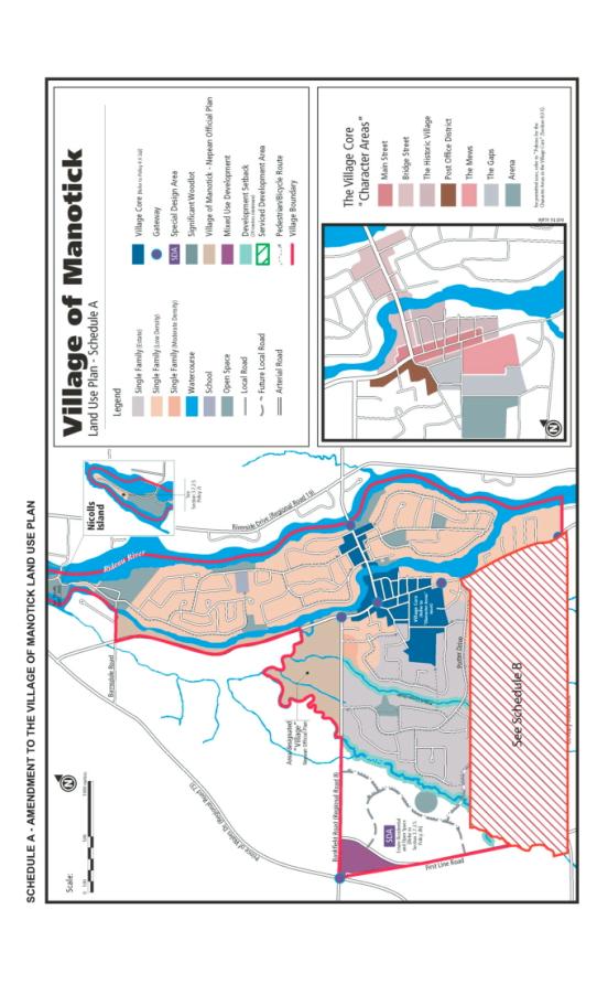
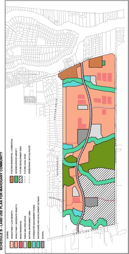
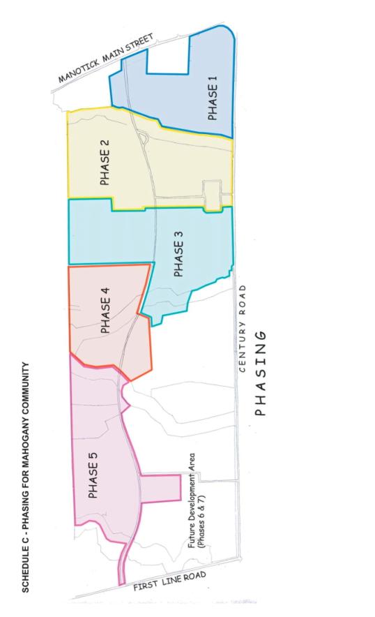
Responses to the Circulation
Document 3 summarizes the detailed comments received from Ottawa Forests and Greenspace Advisory Committee (OFGAC), Rural Issues Advisory Committee (RIAC), the West Manotick Community Association; First Line Neighbourhood Association, the public (technical circulation); Brian Millar and Mike O’Neil (Manotick Community Association).
A) COMMENTS FROM OTTAWA FORESTS AND GREENSPACE
ADVISORY COMMITTEE
OFGAC provided the following recommendations in response to the City's circulation for comments:
1. Retain as a Natural Environment Area the Candidate ANSI, Manotick Drumlin Forest, the NESS Area 506.
Staff Response
The candidate ANSI, Manotick Drumlin Forest, the NESS Area 506 are designated as Natural Environment Area.
2. Retain Community 12 to protect Mud Creek wildlife corridor and preserve the functions and features within the coniferous plantations. Relocate the proposed storm water management pond.
Staff Response
Forest cover within the meander belt of Mud Creek will be retained. A tree preservation plan will be required to minimize the impact on Community 12.
3. Retain and preserve the butternut trees identified within the property. Incorporate these into the overall development plan. For every butternut tree removed, add ten new replacement butternut trees.
Staff Response
Most of the butternut trees are protected as they are within the Natural Environment Area designation. In other areas, butternut trees will be transplanted or replaced with new trees. MNR has recommended that the Ostry method be used for butternut trees within the property; mature trees replaced at 10:1, immature at 5:1, and saplings at 1:1.
4. Place an emphasis on maintaining or enhancing the riparian vegetation along each watercourse, maintain the majority of the mature forests and include the mature hedgerows in the proposal for the property.
Staff Response
The water sources will have a development setback, which allows for maintain riparian vegetation. All subdivision applications will be supported by a tree preservation and planting plan. Mitigation measures are proposed and will be determined detailed design stage.
5. Enhance the watercourse corridors on site with native trees and shrub species to replace lost scrubland and hedgerow habitat and provide up to 60 m wide wildlife corridors.
Staff Response
The watercourse setbacks are 60 metres (30 metres on each side of the stream from high water). Mud Creek has a wider setback of 50 metres on each side of the stream. Enhancement has been proposed as mitigation.
6. Protect the watercourses from the impacts of developments with a 60 m buffer zone. (The original Village of Manotick Land Use Plan – Schedule A called for a minimum of 30 m development setback along all of its watercourses.)
Staff Response
The watercourse setbacks are 60 metres (30 metres on each side of the stream from high water). Mud Creek has a wider setback of 50 metres on each side of the stream.
7. Protect the forested areas from the impacts of developments with a 15 m buffer zone, starting from the woodlot’s edge tree drip zone to the property line of the development (residential, commercial, roads, infrastructure).
Staff Response
An Environmental Impact Statement will be required for all subdivision applications within 30 metres of the Natural Area (Significant Woodlot). The EIS will determine the buffer zone required to mitigate the impact on the natural feature.
8. Introduce oversized culverts whenever crossing the watercourses, to provide passage for wildlife under community roads.
Staff Response
Oversized culverts will be required whenever crossing the watercourses to provide passage for small mammals and amphibians
9. Retain all of community 5 and community 9, not only what is adjacent to the Wilson-Cowan Drain tributary. These communities provide mature forest habitat and form part of the wildlife corridor.
Staff Response
All of community 5 is designated as Natural Environment Area. Community 9 has not been identified as being significant and has not been designated as a Natural Environment Area.
10. No construction be permitted through the ANSI for any infrastructure requirements, including storm trunks to ponds.
Staff Response
The DCP provides for alternative stormwater solutions that would avoid crossing the candidate ANSI.
11. Walking paths throughout the ANSI should not be permitted.
Staff Response
The Pedestrian and Recreational Pathways have been revised, the paths are not shown through the candidate ANSI. . The location and design of all trails are required to be reviewed and approved by the City of Ottawa and the RVCA.
12. Amend Schedule A of the Village of Manotick Secondary Plan to preserve and protect all of the ANSI, NESS Area 506, significant mature woodlots, the endangered butternut trees and the spring fed pond.
Staff Response
Schedule B, the land use plan for Mahogany Community designates the significant woodlots as a Natural Environment Area. The pond will be protected as a neighbourhood amenity and seasonal wildlife habitat.
13. Maintain or enhance a minimum of 30 m naturally vegetated buffer zone or, ‘no touch’ zone from the high water mark for all lands surrounding Mud Creek.
Staff Response
The Plan requires a 50 m setback from Mud Creek. The DCP provides for 60 m minimum wildlife corridors along streams with enhanced planting.
B) COMMENTS FROM RURAL ISSUES ADVISORY
COMMITTEE – Motions from Meeting of
November 27, 2007
Motion
# 1
Whereas the need for
development lands in rural Ottawa is identified as required to provide for an
estimated 30,000 individuals by the year 2028,
And whereas this would represent
approximately 8,500 separate single family homes,
And whereas the City has
embarked on an infill plan which by definition suggests the preclusion of large
scale rural development at this time,
And whereas the present suburban
road and transit infrastructure will not support any major expansion of the
rural residential market,
THEREFORE, BE IT RESOLVED that it is hereby recommended that no village
should exceed the growth in their area by more than 3 percent on an annualized
basis,
AND BE IT FURTHER RESOLVED that it is further recommended that before as
growth of five years allowed is permitted that an infrastructure review be
completed by the City and should schools, roads, emergency services, recreation
and parks be found to be less than the standards acceptable to that community’s
standards, that until these infrastructures are brought up to requirements that
no further housing developments be permitted.
Staff Response
The best way to control the amount of growth is to plan a village for 10 years by designating only enough land for 10 years. Growth occurs unevenly, so to limit pace, the City could designate sufficient land to accommodate 3% growth per year over a 10 year time period.
In the case of Manotick, the Serviced Development Area has been planned for development for a long time. The 1992 Rideau Official Plan designated the village boundary and the 2001 Manotick Secondary Plan provided a detailed land use plan that permitted development. Therefore, it is too late to reconsider how much land should be designated for development within the village.
Motion # 2
WHEREAS it is recognized that the extension of central services to the rural areas of Ottawa is not cost effective,
AND WHEREAS the new technologies for waste water treatment have been proven and are acceptable to the provincial Ministry of the Environment,
AND WHEREAS the City of Ottawa has started to embrace these new technologies,
THEREFORE, BE IT RESOLVED that it be recommended that the City of Ottawa further examine and utilize these onsite technologies to treat wastewater from rural villages of Ottawa
AND BE IT FURTHER RESOLVED that it be recommended that no future
expansion of the City’s central services be undertaken as a preferential
solution for any rural area of Ottawa and that the City of Ottawa should use as
a first option a local onsite solution for any identified needs and future
developments.
Staff Response
Section 2.3.2 of the Official Plan requires a comprehensive servicing study which evaluates a range of servicing options, including costs and benefits, and public water and/or wastewater services to support growth in villages. The City implements alternative services where studies demonstrate that those services are the best solution – such as recently at the Carp Airport and in the Shadow Ridge subdivision in Greely.
For Manotick, a Servicing Options Study was completed that evaluated a range of options including, a new treatment plant to be located in Manotick with discharge into the Rideau River, a series of communal sewage treatment facilities that would discharge into large tile fields, and a central sewage pumping station connected via forcemain to the West Rideau Collector. The Manotick Secondary Plan implements the findings of the Servicing Options Study and requires new development to be on the basis on central services.
C) COMMENTS FROM THE WEST MANOTICK COMMUNITY
ASSOCIATION
The West Manotick Community Association has been very vocal
in their opposition to the Mahogany Community proposal that has been put
forward by Minto. The Official Plan
amendment and proposed Mahogany
Community Development Concept Plan were circulated for comments. The West Manotick Community Association
responded with a 40+ page response to indicate their concerns.
1. The Mahogany
Community Development Concept Plan is contrary to both the spirit and the
intention of the Manotick Secondary Plan.
Staff Response
As disussed in the report, the Development Concept Plan is
consistent with the primary and secondary objectives that are set out in the
Manotick Secondary Plan.
2. Any changes to
the Secondary Plan should involve meaningful community input.
Staff Response
The consultation process as described below in the
Consultation section of this report indicates that there were many
opportinities to provide community input.
There were many issues/concerns raised by the community during the consultation
process. As discussed in the report
the plan has been revised to address the concerns raised.
3. The amendment
is not needed to meet the village's or the City's growth goals for the
forseeable future.
Staff Response
The lands within the village boundary have been planned for
development for a long time. The
village boundary was established in 1992 and the Manotick Secondary Plan
provides a land use plan for the development of these lands. These lands represent 10 % of the expected
growth in the rural area.
4. Added traffic
burden associated with doubling the population of the village.
Staff Response
Many safegueards have been included in the Plan to ensure
that future development is phased according to the provision of infrastructure.
5. The proposal
creates a risk for the reduction in the provision and maintenance of acceptable
levels of Fire, Paramedic and Police services in the village.
Staff Response
Police, Fire and Paramedic Services have indicated that do
not see a significant concern for public safety nor would the proposed
development cause concerns for emergency response.
6. Decreased
accessibility of Manotick's citizenry to recreational facilities.
Staff Response
The DCP provides an
open space system that includes
parks, pathway systems and schools to address the needs of the new
community. The provision of indoor
recreational facilities will be guided by Parks and Recreation's Community
Infrastructure Strategy and Project Listing. A large complex, strategically
located just north of Manotick and south of Barrhaven is planned to service the
indoor recreational needs (twin pad arena, pool and full service community
centre) of new residents in Manotick and the new Barrhaven South area.
7. Potential
negative impact on businesses in the village core.
Staff Response
There is concern that the Mahogany Community will facilitate
the approval of the Trinity "big box" Official Plan amendment
application outside of the village.
However, the Official Plan directs commercial uses to the village and
additional development in Manotick will help to support existing (and new)
businesses in the core.
8. Unacceptable
transition in density of housing between existing portions of the village and
the proposed development.
Staff Response
The DCP provides for transition from the existing
development by larger lots (bordering Manotick Estates) or by providing 6 m
buffers from existing development (along Manotick Main Street).
9. Failure to
make appropriate accommodation for the conservation and enhancement of all
significant natural elements of the development lands.
Staff Response
All of NESS 506 is designated as a Natural Environment
Area. The pond is protected as a
neighbourhood amenity and seasonal wildlife habitat.
10. Potential
negative impact on the opportunity for revitalization and intensification of
the village core.
Staff Response
The DCP provides for a mix of housing units in the Mahogany
Community – up to 25 % of the Mahogany Community will be semis, linked
bungalows, small singles and townhomes.
Range of housing units is a benefit to meet the needs of all age groups;
young people starting out and seniors who want to down size but stay in the
village.
Since there is little vacant land in the village core (3.24
hectares), there is very limited potential for the type of multi unit
development proposed in the Mahogany Community, semis, linked bungalows, small
singles and townhomes, so the development will not compete with the
redevelopment of the village core.
D) RESPONSE BY THE FIRST LINE NEIGHBORHOOD
ASSOCIATION
The First Line Neighborhood Association (FLNA), is not
opposed to Minto Developments Inc., (Minto) development in the Manotick
Development
Concept Plan area (DCP). However, the FLNA is concerned
development be done responsibly in order to prevent adverse conditions on the
existing neighborhood. The FLNA also desires to maintain the residential
character of First Line Road according to the ideology outlined in the Manotick
Special Design Area (SDA) Development Concept Plan. Thus, we provide comments
below regarding the Official Plan Amendment Proposal to the Manotick Secondary
Plan.
1. Density
a. We do not believe the current DCP is “an improvement to
the Secondary Plan .
b. We agree with the majority of Manotick residents (and
surrounding community)
as well as other Manotick organizations that the proposed
density of the
Mahogany Community will be a burden on local roads and will
decrease traffic
safety.
c. We do not believe Minto’s assertion that the Manotick
Secondary Plan as written
is a “dysfunctional plan.” The Secondary Plan intended to
limit growth to 250
homes.
d. As such, we do not support the Amendment to the Manotick
Secondary Plan
that, in part, proposes, “Development will be permitted up
to a total of 2,800 units
to the year 2020 including the Serviced Development Area.”
e. We do believe the proposed density would fail to meet the
primary objective of
the Secondary Plan to preserve and maintain the quality and
character of the life
enjoyed by the people who live or work in (and around)
Manotick.
f. We also believe the Secondary Plan, as worded, should
ensure the Village’s
housing stock continue to consist primarily of single family
detached housing
while allowing for a limited range of multiple family
housing which shall locate in
the Village
Core.
g. As such, we do not support the Amendments to the Manotick
Secondary Plan
that would allow “Multiple Residential” development within
the DCP and allow up
to 25% of the multiple family housing units in the DCP.
2. Traffic Safety
a. It is anticipated First Line Road will experience
additional traffic load from the
planned 200+ homes in the Manotick Special Design Area
(SDA). Additional
traffic load will be experienced from the Seabrook
development further south on
First Line Road as well as from population growth of Kars.
b. Thus, we believe all proposed exits onto all boundary
roads (Main Street
Manotick, Century Road and First Line Road) should be
included in a traffic
impact study to determine ability of existing and future
infrastructure to handle
extra traffic loads, especially (from our point of view)
expected traffic on First Line
Road.
c. We also believe the traffic study should include
industrial and agricultural traffic
currently using First Line Road northbound to Bankfield Road
as a major artery.
d. We further believe the DCP should incorporate walking AND
traffic connections
to the existing Manotick Estates. This would connect the
communities rather than
isolate the Mahogany Community. As well, vehicular
connections should assist
with traffic dispersion. This is in accordance with the
Manotick Secondary Plan
“to support the Village’s character and vision by providing
for the safe, accessible
and efficient movement of pedestrians and vehicles
throughout the community. It
will also promote a pedestrian friendly and transit
accessible environment.”
However, we will defer to traffic impact studies.
e. Some members have suggested access to the 416 at Century
and Second Line
as a direct solution to anticipated traffic.
f. Finally, we request a correction to the Road Network
summary on page 30 of the
July 2007 DCP wherein it describes First Line Road as a,
“two-lane collector
(undivided) with a posted speed limit of 80 km/h.” There is
indeed posted speed
limit signs of 80 km/h on parts of First Line Road. However,
the section of First
Line Road located within the study area (south of Bankfield
Road to Century
Road) is a residential neighborhood with a posted speed
limit of 60 km/h.
a. We believe considerable thought and effort went into the
Mahogany Community
Development Concept Plan. However, our vision is that Minto
sincerely consider
the socioeconomic impact of adding 1,500 – 2,000 units will
have on the
Manotick and rural communities and be willing to reduce
density.
b. Since First Line Road within the study area is primarily
residential (including
future development of the Manotick Special Design Area
(SDA), our members
prefer more prominent exits on the larger arteries of
Century and Main Street
Manotick.
c. We agree with Minto’s proposal NOT to develop retail or
commercial uses in
order to protect the Village Core and its retail businesses.
d. We believe Minto could decrease lot density yet retain
profit through alternative
pricing structures. This will appease the local community
and continue the
prestige of living in a thriving “river” community that
recognizes its rural heritage.
4. Residential Character of First Line Road
We request maintaining the residential character of First
Line Road with the following
recommendations
a. Consider lower density that reflects existing Manotick
residential lots as well as ties
into rural communities, e.g., larger lots and larger
preserved open spaces.
b. Where appropriate, incorporate internal “frontage” road
with lots facing boundary
roads as is being done in Minto’s Chapman Mills development
on Prince of Wales.
c. Where appropriate, mandate landscaping solutions rather
than fences for any lots
backing onto boundary roods.
Staff Response
1. Density:
Growth in the village will be carefully managed to ensure
that future development is phased according to the provision of infrastructure.
At the request of the City, Minto has provided architectural
and design guidelines ensure that new development is consistent with village
character.
The DCP provides for a mix of housing units in the Mahogany
Community – up to 25 % of the Mahogany Community will be semis, linked
bungalows, small singles and townhomes.
Range of housing units is a benefit to meet the needs of all age groups;
young people starting out and seniors who want to down size but stay in the
village
Since there is little vacant land in the village core (3.24
hectares), there is very limited potential for the type of multi unit
development proposed in the Mahogany Community; semis, linked bungalows, small
singles and townhomes.
2. Traffic Safety:
The Transportation Overview accounted for background traffic
growth in the traffic analysis.
The correction to the road network (a posted speed limit of
60 km/h on First Line Road south of Bankfield Road to Century Road) is noted.
A pedestrian and cycling connection will be provide to
Manotick Estates. A road link will not
be provided for as there are safety concerns with a vehicular link (no
sidewalks, winding streets, potential for cut through traffic).
The Transportation Master Plan does not provide for a link
from Century Road to Highway 416.
3. Other Comments
The land use plan provides for an efficient use of land and
infrastructure within the village.
Architectural and design guidelines ensure that new
development is consistent with village character. Traffic will access three main roads – Manotick Main; Century and
First Line Roads.
4. Residential
Character of First Line Road
Architectural and design guidelines ensure that new
development is consistent with village character.
E) SUMMARY OF
COMMENTS RECEIVED FROM THE PUBLIC (TECHNICAL CIRCULATION)
|
Ref # |
Concerns Village character |
Concerns Infrastructure |
Concerns Other |
Suggestions |
|
1 |
·
Adverse effect on character & values ·
Respect secondary plan |
· No infrastructure to
support growth |
|
|
|
2 |
·
Impact on quality of life – recreation services, increased traffic,
demand on fire and police, schools until new facilities added |
·
finalize Strandherd Bridge plans before any significant growth |
· Impact of central services
on wells ·
No multiples |
· keep park at Watterson –
don’t raze woodlot for park · Connections to Potter
& Carrison – pedestrian only |
|
3 |
· Respect secondary plan –
max # houses established · Rural village |
|
|
|
|
4 |
· Plan & schedule A
should remain unchanged to preserve quiet relaxed harmonious nature &
concept of community · No Barrhaven (congestion,
crime, density, traffic, etc.) |
·
Development must be preceded by widening of Rideau Valley Drive &
Main St between Century & Prince of Wales to 4 lanes – to be paid by
Minto ·
Abandon central services for small local treatment |
·
No multiples – keep large lot – ½ acre |
· Residents should be able
to vote on changes · Concerns re infrastructure
must be incorporated into any plan, proposal & construction permit before
it can be approved |
|
5 |
· Plan & schedule A
should remain unchanged to preserve quiet relaxed harmonious nature &
concept of community · No Barrhaven (congestion,
crime, density, traffic, etc.) |
·
Development must be preceded by widening of Rideau Valley Drive &
Main St between Century & Prince of Wales to 4 lanes – to be paid by
Minto ·
Abandon central services for small local treatment ·
|
·
No multiples – keep large lot – ½ acre |
· Residents should be able
to vote on changes · Concerns re infrastructure
must be incorporated into any plan, proposal & construction permit before
it can be approved |
|
6 |
· Doubling the population is
a gross disregard of wishes & plans of residents |
|
|
· Growth management proposal
is misleading – they mean for a total of 2000 by 2020 to a total of 3800 by
2028 |
|
7 |
· Doubling the population is
a gross disregard of wishes & plans of residents |
|
|
· growth management proposal
is misleading – they mean for a total of 2000 by 2020v to a total of 3800 by
2028 |
|
8 |
· strongly oppose 2,000 new
homes |
|
·
Rural Lane - separating community is not the most important element –
what Minto will build is not a rural lane but an asphalt thoroughfare fro
1800 homes with 2500 cars ·
Propose to tear down mature trees and replace it with one dinky
little tree per lot |
· 100% at community meeting
were opposed to the Minto plan – Minto does nothing to address it for each of their promises need to: · have a way to measure
their progress · evaluate if they have met
their terms · recourse to legal remedy
that will lead to immediate rectification of the problem – without having
citizens having to lobby, protest to get what is promised |
|
9 |
· 3600 homes is not
acceptable – conflicts with Secondary Plan & quality & character of
life |
|
·
25% multiples too high – supposed to be directed to village core |
|
|
10 |
· this is urban sprawl · maintain existing
character & density of development |
|
·
central services at a depth of 12 m
may jeopardize the integrity of existing aquifers – Paterson study based
on anticipations & inferences |
|
|
11 |
· rural village with
specified growth path in Secondary Plan · don’t want urban sprawl |
·
severe strain on roads the environment and services |
|
|
|
12 |
· do not want insane growth
in our community |
·
not feasible because of infrastructure, schools, traffic flow |
|
|
|
13 |
· keep as a rural area – no
to urban sprawl |
·
infrastructure can’t handle increased traffic |
|
|
|
14 |
· at variance with OP
policies for infill not urban sprawl antithetical to local, city and
provincial policies · oppose changing the plan
for high density. |
·
|
|
· send to all Manotick
residents not just 120 metres |
|
15 |
· don’t ruin village - don’t need more crime and crowded
streets. |
·
Don’t need more traffic |
|
· Less homes on fewer lots |
|
16 |
·
|
·
there is a reason of the secondary plan - village character and
infrastructure will never hold the amount of traffic proposed by Minto |
|
· Wants to participate &
provide input to make it better |
|
17 |
·
OP requires infill rather than subdivisions outside Greenbelt ·
Not opposed to development – estate lots supported in community ·
Doubling size over short time period impact on quality of life |
·
Roads are already overtaxed |
|
|
|
18 |
·
Quality and character of village threatened by growth of this
magnitude |
|
|
|
|
19 |
|
·
Don’t you think there are enough vehicular problems already |
|
|
|
20 |
|
·
has plan taken into account increased traffic on Century and First
Line Roads ·
how many traffic lights on First Line and Century Road will be
installed ·
what about recreation facilities – closest pool is in Barrhaven – ·
have bike paths been included |
·
will public transit be improved in frequency of buses to make it a
viable option ·
what is being done to protect trees on Century Road |
|
|
21 |
·
oppose the increase in density/population that was agreed to in
Secondary Plan |
|
|
|
|
22 |
·
Secondary Plan call permits only 200 homes – will affect quality of
life – pollution, noise, traffic, commute time, potentially contaminate wells ·
Do not take village and convert into subdivision – want SF on ½ acre
lots |
|
·
do not accept multiple houses outside village core – keep ½ estate
lots to a max of 200 du |
· no access to subdivision from Carrison Dr – access should be via
Century Rd to First Line and/or Prince of Wales |
|
23 |
·
Secondary Plan call permits only 200 homes – will affect quality of
life – pollution, noise, traffic, commute time, potentially contaminate wells ·
Do not take village and convert into subdivision – want SF on ½ acre
lots |
|
·
do not accept multiple houses outside village core – keep ½ estate
lots to a max of 200 du |
· no access to subdivision
from Carrison Dr – access should be via Century Rd to First Line and/or
Prince of Wales |
|
24 |
·
don’t want 1800 homes will affect quality of life by increasing
pollution, noise, traffic, commute time, and potentially contaminating wells
– maximum 200 homes ·
do not accept multiples outside of village core – want development
consistent with Estates ½ acre lots |
|
·
do not want access to subdivision through Carrison Dr. – will convert
quiet street with no sidewalks to thoroughfare – access should be via Century
Road to First Line |
|
|
25 |
|
·
Roads should come first |
|
|
|
26 |
City should support existing secondary plan – why
do we need higher densities |
|
|
|
|
27 |
|
·
bridges cannot handle this influx of cars ·
unacceptable because of sewer and water |
|
|
|
28 |
|
·
infrastructure can’t handle increased traffic ·
Bridge Street and Main St. and River Rd and Mitch Owens cannot handle
current traffic |
|
|
|
29 |
·
Secondary Plan limits development to 250 du ·
Manotick is a village not a suburb |
|
|
· by 2025 oil will be
expensive people will not be able to afford to commute 75 km to Ottawa · Peak Oil forum predicts a
real estate crash in the suburbs – recommends building small self sufficient
communities |
|
30 |
·
Secondary Plan has 2,000 du cap for a reason – transportation |
·
Main Street and Bridge Street can’t be widened to accommodate 60%
increase in traffic without encroaching on existing properties |
|
|
|
31 |
·
keep development limited to 250 as per Secondary Plan ·
character of village will be destroyed and events such as Dickinson
Days, Manotick Boat Show, Santa Clause Parade and village cruise nights will
cease to exist – how do you close Main Street for a parade ·
people in Manotick do not want to live in a tan vinyl subdivision
with cubicle back yards |
·
infrastructure is beyond capacity – Bridge and Main St cannot handle
additional capacity ·
Ottawa sewer system is beyond capacity – how can the Minto
development be accommodated ·
No consideration for additional services – police, fire, paramedics,
medical clinics |
·
What provisions are there for additional power and street lights
needed for 1800 new homes – infrastructure is not in place ·
Suggestion to add buses- there is almost no ridership because service
is slow and poor - having bus service
this area is a worse environmental impact than people driving their cars |
· Minto is successful
neighbouring farms will be forced out of business and will open the flood
gates to be part of Barrhaven |
|
32 |
No
high rise please |
|
|
· want to receive notice |
|
33 |
·
will turn village into a large City |
·
traffic problems are already bad enough |
|
|
|
34 |
·
will character will be destroyed ·
maintain controlled growth of 2000 units |
·
traffic congestion will be a problem |
|
· all forested areas should
be protected – including land south of Potter Dr east of the stream – more
greenspaces needed in same area · provide a tree screen with
a high proportion of conifers adjacent to all of Potter Dr. · pathway access only to
Potter Dr. |
|
35 |
·
will character will be destroyed ·
maintain controlled growth of 2000 units ·
Minto proposal contravenes Ottawa policy of infilling within
greenbelt by creating another high density development that converts Manotick
into another Ottawa suburb ·
Minto proposal violates citizen’s intent to protect village character
|
·
traffic congestion will be a problem |
·
including greenspace in average density conceals reality that the
vast majority of houses will be built on small lots with many townhouses,
characteristic of high density urban developments |
· all forested areas should
be protected – including land south of Potter Dr east of the stream – more
greenspaces needed in same area · provide a tree screen with
a high proportion of conifers adjacent to all of Potter Dr. · pathway access only to
Potter Dr. |
|
36 |
·
character can’t be protected/preserved with town houses ·
Secondary Plan is explicit and clear – interpretation = developers
greed |
·
Inadequate main arteries already clogged ·
Four houses from main exit on Main – have to wait 5 minutes to pull
out |
·
Strandherd Bridge will no help unless truck traffic is banned on
Bridge Street |
·
Why is Manotick Secondary Plan not available for information as part
of the package |
|
37 |
|
·
plan should adhere to 1300-1400 du as per recommendations of
Transportation study |
·
full connection by bike and auto to Carrison and Potter are necessary
to encourage community – they will be slower routes and the Estates residents
will not be harmed ·
relocation of higher density housing should be deferred to a later
date – eliminate row homes – terrace homes and semi bungalows are more in
keeping with the village ·
rows are unsightly and cause parking problems |
·
consider limiting or prohibiting truck traffic on Bridge Street ·
Rideau Valley Drive should not be the primary access – Century Rd
will disperse traffic better ·
Access to First Line Road not wait until later phases – access is
needed sooner |
|
38 |
·
Community does not want increase in population ·
Density is far to high – allow growth for 200 units – don’t double
size over a short time ·
Single family homes echo the character of Manotick |
·
increased traffic – already at capacity- safety issue |
·
impact on library, arena, recreation, medical ·
one tree per lot – this is suburban development ·
object to connections to Potter/Carrison Drive – unsafe – not
designed to handle additional traffic |
·
Committee should vote for what the people want – should hold
referendum ·
Important to protect Maple Forest ·
Expect Council to turn down proposal and staff will back community at
OMB |
|
39 |
|
·
object to collector at connecting to Antochi as it downgrades my
property from a premium corner lot to an intersection residence associated
with noise, light and traffic congestion issues |
|
·
redesignate road connection to Century Road as collector and
connection to Antochi as local road – result would be effective transit
looping |
|
40 |
·
opposed to high density zoning |
|
|
|
|
41 |
|
·
on the assumption that the City can promptly and efficiently resolve
the transportation/traffic issues we wholeheartedly endorse the plan |
|
|
|
42 |
·
should not have the right to change the OP – no modifications
to # of housing units |
|
|
|
|
43 |
·
we do not want the City to
amend the secondary plan |
|
|
|
|
44 |
·
appalled would cast will of community into trash can ·
Manotick is rural not urban – oppose high density |
·
Unacceptable strain on infrastructure – roads, traffic, schools,
medical facilities, police |
|
|
|
45 |
|
|
·
have drinking water tested regularly and will apprise you of any
changes immediately |
·
wants to receive further notice of future meetings |
|
46 |
·
this type of development normally found within village boundaries ·
planned as a slow growing village – 250 per year ·
proposal is 7 fold increase ·
wish to preserve village character
- no Barrhaven |
·
traffic analysis underestimates amount of traffic – only looks at
village boundaries ·
traffic solution – upgrades to roads and intersections (and the
elusive Strandherd Bridge |
·
schools, hockey rinks, other sports facilities at capacity but not
addressed |
·
will fight higher densities at OMB |
|
47 |
·
the PPS vision for communities strong, more liveable and more
sustainable – will help reduce sprawl, preserve greenspace, protect important
natural resources and build better communities where people want to live,
work , invest ·
Minto proposal doesn’t do this ·
There is adequate development land inside greenbelt – intensification
as per OP ·
Limit development to 250 homes |
|
|
|
|
48 |
·
keep scale and character of the village – this proposal is against
the scale and scope of the village plan |
|
|
·
City’s role in process should be to take into account the wishes of
the residents |
|
49 |
·
Don’t oppose development but should be limited to less that 500 and
built similar to Manotick Estates |
·
Primary concern is traffic – traffic impact study is a joke ·
There are no sidewalks to use the street for walking running and
cycling – we are worried someone will get hurt or killed |
·
Minto has done nothing to address concerns- all these meetings don’t
seem to affect the outcome |
·
|
|
50 |
·
citizens overwhelmingly do not want high density ·
will destroy character of village |
·
will create traffic chaos |
·
want new sewage technologies that are green – prior projects show
that sewage pipe leakage has destroyed people’s wells . |
·
|
|
51 |
·
secondary plan protects village flavour and lifestyle ·
defiance of PPS which says no more greenfields development as there
is other land available in the City- there is enough other land to last 37
years |
·
land is outside public service area therefore cannot connect to
public services ·
City has to pay to extend services because development charges are a
mere fraction of what they are elsewhere closer to the City |
·
outrageous assault on community – will result in long prolonged legal
fight ·
if City wasn’t persuaded by the fact 1800 people turned out to
protest plan – they are in for a big surprise in the next round of the war |
·
|
|
52 |
|
|
|
·
would like to be notified |
|
53 |
·
Minot must adhere to the 2000 unit allocation – Minto knew this when
they started planning ·
Village has been growing slowly with appropriate housing – do not
want village to double in size in a matter of years |
·
village atmosphere will be gone - roads clogged and facilities
overloaded |
·
townhouses and stacked townhouses look like City suburbs |
·
Minto should have applied for amendment prior to any planning ·
still want to know why city logo was displayed on concept plans ·
Manotick should not be developed by one developer with big plans |
|
54 |
·
Generally support increase in density – will increase diversity of
people and will enhance cultural, social and economic base ·
Suspect interpretation of PPS policy 1.1.3.7 – the land should be
considered as a designated growth area in the PPS ·
Second suspect interpretation – development has not been slow because
of servicing concerns but bureaucratic interpretation of City legislation
such as parking, heritage, building code ·
Design elements will “ create vestiges or echoes of the former
agricultural use and create myths about former uses – echoes and myths cannot
support village character |
·
Increased density must be supported by appropriate infrastructure and services ·
Proposed road and bridge changes are not sufficient to support the
development ·
Delcan plan to divert traffic from village core is contrary to
Secondary Plan ·
Strandherd Bridge will not alleviate problem because people will
still use Main St to access schools, library, aquatic club, curling rink,
recreational areas used for soccer, softball and other events |
·
Geotechnical report proposes grade raises of over 1 m overlying deep clay deposits – this causes
a risk of cracked foundations, wet basements and yards and sewer backups – it
would be foolhardy to approve this ·
Stormwater – proposal to maximize infiltration practices- may not be
sufficient based on the soils in the area already determined to be
problematic – residents already have problems managing water ·
Wildlife corridor – doubtful if wildlife will respond to enhanced
environment – residents in other areas complaining about coyotes |
·
it is unclear how many units Minto wants to include in the Special
Design Area – this area should be considered also. Proposal’s stated list of benefits are suspect: ·
award wining Inspiration home – buyer not obliged to purchase ·
explore sustainable design – Minto not committed to it ·
preserves natural features – part of larger ecosystem will results in
reduction or loss of species ·
provides connections to existing village – connections desirable but
vehicular dependence not reduced ·
additional elementary school alternatives – doubt new school will be
approved ·
creates a provision for public transit - - depends on increased ridership – not the case elsewhere and
can’t be predicted it |
|
55 |
·
chose to live in Manotick – village not standard urban subdivision ·
don’t make same mistakes of other areas – remember Unionville now
assimilated as part of Toronto – this is urban development that can be
dropped into Barrhaven ·
proposal does not blend with historical growth pattern ·
pieces of trim and ¼ tree per block doesn’t make this village |
·
live in Manotick – accept that we would not have central services –
take extra care of environment at our expense ·
resolve infrastructure issues before development is given green light |
·
if City is in deficit position why are rural development fees a
bargain for Minto |
·
Minto has rights but what about rights of residents – listen to the
majority of residents ·
Say no to urbanization of rural area ·
ARAC created to understand balance to urban/rural area |
|
56 |
|
|
|
·
wants to be notified of decision |
|
57 |
·
want to maintain rural village lifestyle – Stittsville used to be
charming village community - surge of
concrete loss of greenspace ·
maintain character – need slow growth |
|
|
·
requires a commitment to greenspace and preservation of natural
beauty ·
requires strict regulation of businesses and homes so they continue
to enhance rural character |
|
58 |
·
it is the village not the FDA area that is allowed to grow to 2000 du ·
why is it necessary to expand to 2000 du |
·
Main Street is a single lane that cannot be expanded – will there be
a no left turn sign from the new development onto Main Street forcing traffic
to use Century Road - many of us use
this approach to Firefly Lane or the Fire Stations ·
or will traffic be diverted through Potter Drive and Carrison Drive
communities – How unfair! ·
Let Minto use wells and septic with appropriate sized lots like the
rest of the village ·
don’t expect me to subsidize water and sewers |
|
·
business in the village – it is not reasonable to assume that the
population will increase when one sets up a business |
|
59 |
|
·
traffic on bridges that are part of the community will get worse ·
cannot use streets as a transitway |
·
concern about connecting with Estates - streets are quiet and have low traffic volume – more traffic
unsafe for children and us – likely insurance premiums will increase for
homes and cars – crime would escalate |
·
it is possible to find conditions under which development can be
supported and look forward to being part of that process |
|
60 |
|
|
|
·
wants to be kept informed of all developments |
|
61 |
·
guts and betrays principles in the secondary plan |
·
traffic is the worst impact – consultant report in an amateur
exercise ·
mythical Strandherd-Armstrong as the panacea, the bridge to nowhere.
Nowhere because it was designed for Light Rail, doesn’t link major highways
and won’t be favoured by drivers.
Traffic will continue to use our narrow village bridges as a ring road
but this traffic will be compounded by 4000 extra vehicles. Any references to
improvements in road access were far away from Manotick both geographically
and in time. No reference was made to how the village itself was to swallow
this mass invasion of city-bound vehicles ·
Getting emergency vehicles across these already clogged island
bridges is a frightening prospect. Adding to the traffic on these bridges is
both unprincipled and extremely dangerous to the people of the north and
south islands ·
The village recreational facilities are few and dilapidated and will
not support the additional population |
·
environmental treasures like the pond on the east side of the Minto
lands and the old growth forest where rare walnut trees prevail will fall in
the interests of construction efficacy to the bulldozers ·
ungovernable geographic sprawl and cannot be condoned or even
afforded by a city that is to all intents and purposes broke. |
·
concerned that people outside of 120 m not included on contact list ·
Minto knew the rules when they purchased the land |
|
62 |
·
Character of the village will be destroyed – high density housing
will turn village into a suburb of the city they surround such as Barrhaven,
Orleans and Stittsville |
·
infrastructure mist come first – roads, schools, central services
cannot service existing loads ·
bridge and road plans are inadequate – Bridge St. ·
main sewer in the park near Potter will lead to “teething problems”
that will be someone else’s problem once the developer has moved on |
|
·
Community is powerless in debate – process designed to give illusion
of consultation ·
Initial discussion ·
Quick attempt to force issue through ·
Set up consultation over the summer ·
Slide project to divide an conquer – superstore development beside
Tim Horton’s ·
Superficial change to original plan ·
Project process with media blitz to persuade people consultation has
happened based on superficial changes |
|
63 |
·
Oppose changing village plan
- keep self contained small community |
·
New homes will be a burden on existing commuters – roads cannot
accommodate more |
|
|
|
64 |
·
there is no need for additional housing- there is no housing shortage
and does not follow City focus on development within the greenbelt and
reducing suburban sprawl |
·
primary concern is increased traffic on Main Street – off site
improvement such as Strandherd Bridge will not address this ·
what is the process for tying future development to future
transportation improvements ·
who/when/what consultation will determine if transportation
improvements are required prior to development ·
are sidewalks and traffic lights pedestrian walkways outside Minto
lands included ·
all this need to be considered prior to amendment |
·
there are several small side streets to enter the Mews – many with
limited visibility due to parked cars – safety issue with increased traffic ·
Is Eastman entrance planned to be a primary access point to the Mews
for the new development? If so will
the existing sidewalks be extended for pedestrian traffic since a pedestrian
walkway and a new road are proposed to connect the new development to Potter
Drive ·
Are additional traffic lights and or pedestrian cross walks going to
be added on Main Street? |
|
|
65 |
·
strong objection – as a resident of Potter Drive do not want mass
development in my back yard ·
development will change characteristic and flavour of community |
|
|
|
|
66 |
·
Belgium has abundance of well planned towns and villages with
historical properties respected and enhanced through careful planning ·
The concept of cramming 1800 houses on a tiny space in a historic
village is unheard of – this would be an enormous mistake |
|
|
|
|
67 |
·
to accept fast growth and high density is antithetical to Secondary
Plan ·
proposal is at variance with Ottawa planning policy for infill and
reduction of urban sprawl |
|
|
·
strongly suggest notice be sent to all residents not just within 120
m |
|
68 |
·
cease irresponsible practice of paving over farmland |
·
look for sewage system between big pipe and septic systems –
de-centralized systems benefit innovation and environmental progress |
·
stormwater management system should be and example to everyone – not
designed for minimum cost |
·
Minto should foot the bill for top notch transit system ·
Business structure should be preserved – this should not be an excuse
to build Wal-Mart in Manotick ·
Insist that any development is something entire community can be
proud of - giant developments north
of Prince of Wales are disgusting |
|
69 |
·
Oppose development of more than 250 homes ·
Addition of more development will change Manotick from rural
subdivision to subdivision like Barrhaven ·
Ottawa OP precludes significant densification outside urban core –
agricultural land will remain agricultural, village remain villages and urban
sprawl will not be perpetuated |
|
|
·
no amendment should be considered until a clear majority of villagers
express desire to change |
|
70 |
·
secondary plan put in place to control growth of village ·
proposal represent 7 fold increase and does not take into account
other builders ·
densities increased beyond those contemplated and would allow
significant non single family in an are primarily for single family homes |
|
|
·
to approve the amendments would beg the question – why bother to do
the secondary plan in the first place? |
|
71 |
·
residents have worked long and hard to control growth to 2000 units
by 2020 ·
loss of village charm – traffic, noise, pollution ·
doubling size of village would spell the end of Manotick |
·
have seen what sewers do to quaint villages – visit Stittsville |
|
·
have attended all public sessions and listened as parties tried to
alleviate concerns – they have failed miserably ·
request that city not just inform residents of decisions rather
continue to engage us and ensure our voices are heard and actioned |
|
72 |
·
moved to Manotick because liked open spaces not cookie cutter houses
of Barrhaven or traffic or chaos associated with City environment ·
8-10+ houses per acre – Manotick probably averages 1-2 houses per
acre – ·
Manotick has a rural lifestyle – adding density doesn’t fit in |
·
traffic is already horrible in downtown Manotick – adding 2000 cars
is crazy ·
why is no transportation/infrastructure proposal being presented ·
why did the city ignore Manotick’s development plan |
·
why does Ottawa want a one size fits all approach – ·
why did the City try to fast track the Minto proposal - giving Manotick only 3 weeks to respond
to the proposal |
·
Minto presentation indicated Council approval in November – this is
presumptuous – interesting Minto feels that Council is attainable – Can you
comment on this? ·
Minto has engaged a public relations firm Hill and Knowlton to manage
public relations for the project – this firm has been hired to lobby
politicians Minto’s behalf. Can you
comment on this? ·
In the past top lobbyists have been successful for the
developer. How would I obtain this
information |
|
73 |
·
Secondary plan should not be changed |
·
Strandherd Bridge should be in place before housing projects |
|
|
|
74 |
·
grossly out of scale with Manotick Secondary Plan – the total number
of houses that can be built is 300 ·
why should Minto be allowed to increase densities – Manotick is a
rural setting an densities must not be allowed to increase |
|
|
·
poor wording in secondary plan – clarify policies to accommodate
original intent of document |
|
75 |
|
·
have not seen assurances in traffic study that will support increase
in traffic beyond 2013 with or without Strandherd Bridge ·
traffic study suggests that only 1300 homes can be constructed |
·
concern about connection to Carrison will increase traffic on
Carrison, Potter and quire possibly Scarfgate, Wicklow and Revell Drive |
|
|
76 |
·
opposed to changes in secondary plan and support efforts of West
Manotick Community Association to resist this development |
|
|
|
|
77 |
·
oppose sheer volume Minto is trying to jam into village ·
do not need a number of townhouses filled into that small area. |
|
|
·
Minto could make just as much money if they designed an executive
neighbourhood that more closely approximate the feel that we have |
|
78 |
·
Hard to understand how developer can propose wholesale changes to
spirit of approved plan ·
Development plan and community architecture for Manotick and area
cannot support proposed accelerated growth – with proposal for big box mall
the problem is even greater |
·
Without massive road widening, sewers and bridge improvements the
community will not be able to support the proposed increase in population ·
Until such plan for infrastructure is designed and approved by City
council, no development beyond the approved community plan should be approved |
|
|
|
79 |
·
small town village – the reason we came here will be shattered by
1800 unit residential development |
|
|
|
|
80 |
|
|
|
·
Minto has made a number of changes to address concerns raised by the
community – natural areas, greenspace, reduction in number of multiple units
to 25% What makes village a village: ·
Move away from grid to a cluster layout around shared greenspaces
heavily vegetated private and shared land creates a beautiful and neighbourly
community–access from back yard to
orchards, swimming pools, parks, gardens and greenbelts within Village
Homes |
|
81 |
·
Reject description of secondary plan as dysfunctional – residents
have spoken for best interests of community – sustainable community 2000 du
to the year 2020 ·
Increase 2000 du needs to be accompanied by a jobs growth to 2000
jobs by 2020 – the plan ties housing to jobs for a sustainable village ·
Reject any multiple housing units outside the village core – the will
of the people is to put restrict multiples to the core ·
There is no valid reason to increase the density of single family |
|
·
reject changes to schedule A except for : 1.
fix ANSI boundary 2.
replace Single Family Estate with a woodlot 3.
show schools and open space 4.
remove road connection to Watterson |
|
|
82 |
·
extending the limit from 2000 homes to 3600 is not acceptable –
exceeds the design capacity of the secondary plan and is not in keeping with
primary objective ·
25% multiples is far too high – will change character of village –
housing density to be directed to village core ·
housing density to be concentrated in core not outlying areas |
|
|
|
|
83 |
·
proposal will kill the village and turn it into a suburb like
Barrhaven ·
contrary to Ottawa OP which stressed growth by infill ·
250 limit must be kept |
|
|
·
draw a line in the sand and save villages which fall outside city
boundaries |
|
84 |
·
oppose any plan that would add to the density of Manotick population-
secondary plan policies keep character and beauty |
|
|
|
|
85 |
·
build only single family homes (1 to 2 acres) at fair market value ·
no multiple high density ·
want to retain village feel – don’t want Barrhaven |
·
use treatment system currently used across from arena for sewage –
don’t bring big pipe – didn’t work in Munster/Richmond |
|
|
|
86 |
·
secondary plan reflect historic roots ·
village centre always surrounded by quasi neighbourhoods on
reasonable sized lots- allows community members access to roads and other
infrastructure |
·
traffic problems are an obvious problem – doubling population will
exasperate this further |
·
big box stores will arrive to service all of the people – more
outlying traffic will then come to the area effectively killing off our
village small stores and we will become another Barrhaven |
|
|
87 |
·
will fundamentally change the character of Manotick from an ex-urban
rural community to a typical suburban dormitory similar to Barrhaven,
Stittsville- objective of secondary plan is to preserve and maintain quality
of life and community’s character ·
does not represent gradual incremental change – 2000 du by 2020 |
·
there is no support for the changes to transport infrastructure which
are required to support the community of double its current size |
|
·
all development was expected to preserve the character of the
village, namely estate and low density housing – expectations supported by
secondary plan approved by Ottawa – not acceptable for the city to alter it
in such a short period of time |
|
88 |
(article
from the Guardian) ·
Sociability Survives in Micro-Rituals of Daily Life |
|
|
·
street design helps to instil sense of community ·
according to new manual for streets planners should encourage walking
and informal social interaction – laces to linger and fewer dead ends so
streets are permeable for those on foot |
|
89 |
·
this should be treated as a new plan
- it cannot be considered as a simple amendment It is not in the interest of Manotick to: ·
more than double the size to the point where it can no longer be
considered village ·
completely change (ruin) the current character of the village ·
significantly increase traffic and further magnify traffic problems
that exist today ·
fundamentally change the rural surroundings that make Manotick the
village it is today |
|
|
·
if the secondary plan is to be changed it should be done in
conjunction with the community associations working together to develop a
plan the community can get behind |
|
90 |
·
oppose excess of 200 homes on Minto lands ·
|
·
very concerned re traffic from more that 200 units – don’t allow
degradation of traffic flow |
·
concerned about potential property damage and inconvenience if sewer
installation goes ahead ·
do not want sewer on my property and don’t want to participate in any
expense as a result of city installing sewer infrastructure bordering my
property |
·
support pathway extension to Potter NOT a road |
|
91 |
·
will transform small country village into another Orleans/Barrhaven –
want slower quieter atmosphere |
|
|
·
amalgamation – voice of rural community deafened by big city
developers and their own priorities |
|
92 |
|
·
development proceeding without infrastructure and integration into
existing community – there will be tremendous stress on roads and community
facilities. |
|
|
|
93 |
|
|
·
location of entrance/exit located at Antochi lane which directly
faces my property - ·
located on steep slope into village ·
would hinder access to fire station ·
original 3 concepts show access at Orchard Hollow Drive (where it has
not impact on residences |
|
|
94 |
·
support secondary plan as adopted
i.e. no more than 250 single family units by no sooner that 2020 |
·
concerned about adding 1,800 du on transit in and out of
Manotick. There is already heavy
traffic on Bankfield every rush hour |
|
Suggest the following in the regrettable eventuality Minot has its way ·
there should be a buffer zone adjacent to Potter and Watterson –
singles at same density as estates ·
Minto should not be allowed to cut down trees separating Brookfield
Estates from proposed development ·
Multiple units should not be permitted in proposed buffer zone ·
Carrison should remain a cul de sac and never communicate with
proposed Minto expansion ·
Do not want to under any circumstances have to hook up to city water and
sewer nor do we want to be financially responsible in any way for expansion
of City services |
|
95 |
·
Residents prepared a plan for the future community as a continuation
of low density character of the village ·
Recent successful development north of Bankfield illustrates
viability of expanding the village according to the guidelines of the
secondary plan ·
Higher density proposed is profit and sewage collection driven with
little or no regard for negative impact on the community – will convert the
village into a suburb |
|
|
|
|
96 |
·
nice village with large lots will be an extension of Barrhaven ·
why is city greedy and allowing villages to be destroyed |
·
traffic is bad already and there is no way our roads can accommodate
another 4,000 cars ·
big pipe is problem in Richmond and Munster with breeches and venting
off |
·
city growth has been overestimated there is no reason for all this
development |
·
work should be done as in UK and Europe to redevelop cities to make
them attractive and no allow farmland to be gobbled by sprawl ·
Rideau Canal designed as World heritage site – greater argument to
preserve village ·
Use the lands in question for recreational use |
|
97 |
·
Oppose housing density which will change character of the village |
·
Changes to official plan must be based on prior development of
supporting infrastructure ·
Sewage problems of Hillside Gardens and Core – city must have open
mind to best possible solution and
must be kept separate from larger question of Manotick Official Development Plan ·
Minto is taking advantage of
city and taxpayers footing the bill |
|
·
citizens of Manotick need to be involved in an acceptable plan for
the Minto lands – expect the City to facilitate this ·
if amalgamation had not occurred there would have been no appetite to
discuss an inappropriate proposal – Planning Department stick handles Minot
proposal - openness and transparency
of planning dept is lacking |
|
98 |
|
·
village will be destroyed because of unresolved traffic management
situations – confirmed in Section 7.1 of Transportation Overview ·
the traffic report is not complete and more analysis needs to be done
particularly on the impact on the current village ·
Main Street will choke and drivers will choose alternative routes on
streets east and west of Main Street which are not designed for increased traffic ·
Report does not address traffic densities on Garrison and Potter –
the tee connection at Bankfield and Potter is addressed to recognize that
additional traffic will flow though the Estates to Bankfield – no traffic
flow is available ·
Figures 5 & 6 of Delcan report do not show the connection to
Potter ·
Page 20 of Delcan report – there is no basis to proceed – no precise
plans only general ideas. |
·
Situation by the arena and Centennial Park - the parking lot overflows along nearby streets on Doctor
Leach and Village Walk – this is hazardous as the area is populated mostly by
seniors. |
·
residents beyond the 120 m also affected ·
need a comprehensive traffic management plan and a funded program to
implement this plan to keep pace with development – street and traffic
management plan specifically the core east and wet of Main St and Manotick
Estates ·
provide sidewalks on many more, if not all, streets in development –
will encourage people to walk and cycle and reduce vehicle traffic ·
Minto refers to “A Green Community” need comprehensive system of
sidewalks and to enhance credibility |
|
99 |
·
Oppose amendments to secondary plan ·
Oppose big box development adjacent to village boundary |
|
|
·
our heritage woodlands, ponds, wetlands and waterways must be
preserved within existing village boundaries |
|
100 |
·
infrastructure does not humanly preserve village ·
give consideration to hard work and preservation of first residents |
|
·
lacks planning with regard to emergency services, sewage |
|
|
101 |
·
return to Manotick secondary plan that was first approved |
|
|
|
|
102 |
·
I join the majority of citizens who oppose the plan ·
Density is still too high ·
Make a smaller community that won’t threaten lifestyle |
|
|
|
|
103 |
|
|
·
what is the status of Henry Creek which runs along the west side of
MacLean Court Condominium? |
|
|
104 |
|
·
take care of all infrastructure first – ·
do something about traffic especially traffic that uses Bankfield,
Main, Bridge and Mitch Owens as a by-pass to 416 |
|
·
require gov’t help in brining services so we can stay in our homes at
current cost estimates. |
|
105 |
·
Manotick is different from a tract subdivision – it has a past ·
Existing heritage, village
core, employment centre should be nurtured and protected – take steps to do
this – then see what expansion is appropriate – Minto proposal is premature |
|
|
|
|
106 |
·
slow growth – effort to conserve different environment – community built their own facilities ·
secondary plan to be reviewed after 5 years |
·
roads, arena, soccer fields are already over crowded ·
no indication that Armstrong Bridge is further along than is has been
for 20 years |
Need
to examine ·
Manotick has a role to play as a village in the city. PPS requires detailed analysis of whether
the community can absorb such an increase ·
Do not see a compelling reason for 1800 houses – population
projections do not demonstrate a need – Minto proposal is premature |
·
respond as a business in the core – without community sewers the core
is doomed ·
with sewers the core will survive, regeneration will take place – not
until then should there be a change from the present plan ·
a five year review by the community would be in order as sewers
seemed immediate six years ago ·
timing and details should be reviewed and Minto’s request is
premature. ·
Minto purchased the land with limited development potential |
|
107 |
|
·
Long Island Road has, 2 schools, a church, no continuous sidewalk and
a bus route and is already used by motorists exceeding the speed limit to
bypass rush hour hold-ups at Bridge and Main ·
How can you approve the Minto development without better
infrastructure? |
|
|
|
108 |
|
·
infrastructure needs to be brought in line with |
|
|
|
109 |
·
no benefit to present community of homeowners |
·
traffic is already horrendous- the infrastructure is not there and
noting should be amended until it is ·
Strandherd will not be an acceptable alternative to Bridge Street |
|
·
oppose Minto proposal – does not mean I do not support the North
Island’s petition |
|
110 |
·
too significant a change will be detrimental to quality of life |
·
infrastructure not in place to support these changes |
|
|
|
111 |
·
expansion of City density to rural area is poor planning ·
encircle our village with high density housing – Ottawa doesn’t need
that kind of neighbourhood |
·
do not want congestion, traffic strain on neighbourhoods |
|
|
|
112 |
|
|
|
·
West Manotick Community has taken it upon themselves to copy a City of
Ottawa document and distribute to 3,500 homes – nobody at the City knows
anything about this – it could cause a conflict because you are only allowed
to send out to the 1 kilometre distance – you might want to look into this. |
|
113 |
·
Violation of secondary plan – density exceeds this limit ·
Inconsistent with Provincial Policy Statement – new development can
only be specified where there is a demonstrated need for the land – calls for
intensification of developed areas as opposed to development on agricultural
lands on the Minto site ·
Doubling population will destroy rural character ·
Additional housing will attract big box on periphery which would be a
blow o the village core |
·
Traffic is currently at saturation point ·
Delcan traffic study is not convincing – even if Strandherd Bridge is
built ·
Fire services, medical facilities, sports facilities and community
centres would be lacking and difficult to develop in the context of a small
village |
·
if Minto success in face of clear legal restrictions it sets a
dangerous precedent for other villages |
·
secondary plan was reworded without legislative authority by addition
of clause about central servicing – this did not change the intent of the
original clause but Minto is using it to imply that higher density would be
sanctioned |
|
114 |
·
no to development on this scale ·
existing plan provides a reasonable level of growth |
·
traffic, roads commercial development totally of a character foreign
to village atmosphere |
|
|
|
115 |
·
oppose alteration of secondary plan |
|
|
|
|
116 |
·
rapid construction of the number and type of housing units would
radically alter the unique character of the village ·
concept fails to preserve overriding concept of a harmonious
environment based on a historic core ·
fails to take into account the vision the spirit and provisions of
the secondary plan – developers should have been aware of the provisions of
the plan ·
need to ensure harmonious and progressive growth in keeping with the
historical evolution of the community |
·
would severely aggravate traffic problems – not only would there be
congestion and safety concerns on Main, Bridge and Bankfield- there would be
increased traffic cutting through residential parts of the Estates e.g. along
Carrison to Potter as routes to Bankfield or Rideau Valley ·
village services and recreational amenities will be strained |
|
|
|
117 |
|
·
housing density contradicts the Manotick’s secondary plan and will
create traffic difficulties on Main and Bridge streets that already seem to
be operating at capacity during rush hours. |
·
Opening Carrison Drive and Potter Drive connections for vehicular
traffic will make the two drives into thoroughfare as it creates short-cuts
from the proposed development area to Manotick Mews and Main Street ·
Yet those drives have been designed, as residential streets without
sidewalks and any significant traffic will definitely increase risk for the
local children and residents. · There are no provisions
for the medical, recreational facilities, etc. |
|
|
118 |
|
|
·
need traffic light at school so south island residents can access
Bridge Street |
·
add cross walks on Main street |
|
119 |
·
failure to adhere to secondary plan is ins opposition to wishes of
community ·
1800 units will destroy village character |
·
infrastructure incapable of handling increased traffic flow through
narrow bridges and streets ·
more than half of the village does not have sidewalks or road
allowance wide enough for pedestrians to walk |
·
additional air and noise pollution this development would bring ·
unable to meet additional demand for emergency services (police &
fire) as well as recreational and cultural facilities |
·
acceptance of amendments would be breach of trust for agreements
understood at time of amalgamation |
|
120 |
·
The proposed changes are not in accordance with the original
secondary plan |
·
Residential concerns regarding traffic and services issues have not
been adequately assessed or addressed. |
|
|
|
121 |
|
2 aspects I consider ludicrous: ·
absence of planning of infrastructure notably roads ·
a community of 5,000 people
of primitive septic tank technology |
|
|
|
122 |
|
·
when will Manotick east of Rideau River be considered for sewer and
water ·
What is plan if the Bridge does not alleviate traffic congestion? |
|
|
|
123 |
·
Manotick’s charm is that it is small and well maintained village –
thanks to efforts of West Manotick Community Association I hope it remains
that way. |
|
|
|
|
124 |
·
old development plan was in effect for 15 years – why change
suddenly? |
·
can put 10 lbs into a 5 lb bag – structure of roads, lights, and
overall village can’t handle proposed growth ·
sewers have been a hot topic for years – solve Hillside Gardens first
– why solve Minto’s problems now? |
|
|
|
125 |
·
opposed to rate of growth – Manotick has developed over 160 years –
population will now double over 10 years – we will lose our identity ·
limit number of homes to as few as possible – limit to 300 over ten
years |
|
|
|
|
126 |
·
doubling the population is too much too fast – out of proportion and
will destroy the character Secondary Plan is meant to protect |
·
road system cannot handle current demands let alone growth – there is
no acknowledgement that a new shopping centre is proposed to the east |
|
·
the circulation process has been a farce – there is no evidence Minto
takes villagers concerns seriously ·
at amalgamation hoped for professional thoughtful approach to
development issues – did not expect to be steamrolled by developer with
apparent cooperation of the City |
|
127 |
·
adding 1800 homes in 10 years will not preserve or protect village
character – it will no longer be considered a village |
·
current main roads are at or above capacity and the existing traffic
improvements (Strandherd Bridge, widening Prince of Wales) will not alleviate
current or potential traffic issues in the core where every resident will
travel through – no evidence the City will commit to solving the problem ·
safety issues – more cut through traffic and no sidewalks ·
public facilities are at
capacity now – City has not provided a plan to accommodate new residents |
|
|
|
128 |
·
secondary plan states that housing development is not to exceed 2000
units no sooner than 2020 – Minto proposal drastically exceeds this –we
welcome new housing development if it aligns with the agreed upon direction
of the secondary plan ·
as the city continues to expand the level of development density both
within and around villages requires careful management |
|
·
why have an official plan if amendments can be readily granted to
accommodate those few who it does not suite to the detriment of the broader
community |
|
|
129 |
·
appalled City is even considering proposed amendment to 2001
secondary plan, which would increase the density for single family and add a
new residential density for multiples ·
try reading Ottawa Citizen Sept 11, 2007 article re the need for
safety, peace, and quiet – these values will be destroyed if the increased
density is approved |
·
sitting in traffic on Bridge Street is in contravention of the City’s
Idling Control By-law ·
it is too bad if you are in an ambulance stuck in Manotick because of
traffic ·
if approve the development will add to urban sprawl, increase traffic
on roads incapable of supporting current traffic volume and import health and
safety issues associated with a dense urban population |
·
higher density housing is the cause of any societal ills – people
need space – children need a safe environment in the back yard – a central
park in not the answer because it requires structured play |
·
need quiet environment to recuperate from noise, traffic – high
density does not allow us to get away from this ·
what good is protecting natural features if you have to go though
kilometres of streets wall with houses to reach a quiet spot ·
City should study is violence and increasing police budgets could be
reduced by re-examination of city’s housing mix policy and density issue |
|
130 |
|
·
will place strain on already overtaxed infrastructure i.e. roads,
bridges, sewer systems |
·
will have a negative impact on the environment ·
poor planning – not strategic – more urban sprawl without services
i.e. a tax base to support it |
|
|
131
|
·
Manotick is a tourist destination – allowing 1,800+ subdivision to go
ahead will eradicate the village as we know it ·
Minto bought the property in the full knowledge of the restriction in
the secondary plan – the population has chosen to locate here in the belief
they were protected by a coherent plan ·
The City is moved by no other motive than the approval of inward
investment regardless to the cost of the existing population |
·
Transit situation has reached its peak - there is no viable transportation plan to correct the
problems let alone accommodate increased traffic from 1800+ units. ·
No conceivable transportation improvement short of a subway to the
heart of Ottawa has the slightest chance of mitigating the destruction of the
community. |
|
|
|
132 |
|
·
village the current village
reflects the village feel with low traffic streets (with no sidewalks) shared
by cars, cyclists and pedestrians -
doubling population will require all traffic to cut through the existing – a
disaster to the Manotick Estates neighbourhood |
|
·
the community spend many years using board consultation to develop a
carefully thought out secondary plan – it would be a shame to see developer
with slick lobbyists easily sway public servants and officials entrusted by
the community |
|
133 |
|
|
|
·
do not accept Minto’s
proposal to change the Secondary Plan – listen to the people |
|
134 |
|
·
need to resolve transportation issues before there can be any growth ·
getting to and from the village core on foot, by bike, wheel
chair, roller blade, stroller is unsafe
through the village core ·
driving can be frustrating and dangerous with the amount of traffic
(especially heavy trucks) |
|
|
|
135 |
·
to much density for village – follow the secondary plan |
·
traffic is bad now – proposed development is going to mean that a bad
situation will become an unsafe situation |
|
|
|
136 |
·
too dense – follow the secondary plan |
·
traffic is too heavy already – plan will worsen an already bad
traffic problem |
|
|
|
137 |
·
urban densification - doubling the size of the village is in
contravention of the secondary plan ·
will destroy village character and ambiance that villages have worked
hard to sustain |
·
urban style growth will lead to unmanageable and dangerous
infrastructure problems |
|
·
this places a corporation’s desire to make profits over the wishes of
the people ·
Minto can reap its profits by building its urban style development in
a location that is more appropriate ·
Groups think they can ride roughshod over the wishes of residents who
believe they have the legal protection (secondary plan) to use their influence to have the
legality papered over with an amendment |
|
138 |
·
Understand the need for different types of housing to accommodate
young families and seniors in the community – however to allow a doubling of
the population within 10-15 years after 150 years of controlled growth will
destroy the rural character of Manotick ·
Secondary plan was developed for controlled growth and protect
village character that has evolved over 150 years |
·
Infrastructure is not in place to support this expansion ·
Central servicing has been an ongoing requirement to the two priority
areas ·
By allowing the request the City will be allowing the subdivision to
proceed without sufficient municipal planning and priority for setting
sustainable transportation, facilities (community centres, parkland, schools,
etc.), residential development, central servicing, and public transportation
alternatives |
·
New suburban communities impact on (Riverside South, Stonebridge,
Mattamy) impact on our village roads and facilities and is already causing over
usage problems |
·
With Strandherd Bridge still years away recommend that the City spend
the next few years addressing the planning issues identities identified above
through constructive studies involving all stakeholders |
|
139 |
·
What type of city do we want and why are developers allowed to drive
city development design- we are allowing developers to take away the elements
of uniqueness and greenspace in our region and develop monolithic condensed
housing neighbours ·
What is the goal of the city when it comes to surrounding villages –
do we just say goodbye to villages and allow urban sprawl or does the city
want to have an active hand in the careful development and expansion of
villages keeping the integrity of village life alive in the Ottawa valley |
·
Traffic is totally out of control at the moment – single lane bridges
have turned into commuter lanes beyond their capacity with transport trucks
winding their way through village corners, west commuters are using Manotick
as the south link across the Rideau River ·
Manotick cannot accommodate more traffic ·
Traffic studies released by developer present picture of
accommodation – it is important to be realistic – 200 cars generated
throughout a 24 hour period are going to try to traverse already congested
roads between 7-9 am and 4-6 pm |
|
|
|
140 |
·
secondary plan created to ensure that Manotick is not destroyed by
rapid expansion – Minto proposal is diametrically opposed to the Plan’s
primary objective to preserve and maintain the quality of life… ·
no village that doubles its size in a decade can preserve its
character ·
high density will destroy
rural character ·
design uniformity will drive down property values |
·
Main Street and Bridge Street will become impassable. There are no solutions to avoid this –
Minto severely underestimates current and future problems – the City should
perform its own traffic studies |
·
complementary commercial big
box stores will inevitably follow the population forcing businesses out of
the village core |
·
there is no demonstrated need to amend the plan and no community
support it – profit driven imposed on Manotick by external forces who have no
lasting interest or respect for the village or inhabitants ·
Ontario’s villages especially within amalgamated cities , need
protection so they can withstand developer’s attempts to turn them into
homogeneous boring suburbs |
|
141 |
·
Proposed development does not fit into the current characteristics of
the neighbourhood |
·
Local traffic infrastructure does not support the size of such
development |
|
·
majority of residents do not support the development |
|
142 |
·
Minto plan is not in keeping with character of village – very nice
for Kanata, Orleans and Riverside South but not for Manotick ·
contrary to the secondary plan that that residents worked long and
hard to develop. ·
Our rural lands need to be protected ·
Strongly object to changing the current housing allocation to 1300
new dwellings and 1800 by 2028 |
·
traffic cannot be managed by current road structure ·
no longer take kids to the pool because it is almost impossible to
make a left turn on Bridge Street ·
oppose central services to the area – on site treatment makes more
sense – like the one servicing the town house development |
·
lands in question are habitat for many forms of wildlife and the
waterways are essential for the frog and toad population |
·
live on Potter and never received a survey |
|
143 |
·
secondary plan reinforce that village would maintain qualities of
slow managed growth, cap on the number of homes, homes consistent with what
the village currently has (single homes on well and septic and mainly estate
lots) ·
The Secondary Plan was developed over a ten year period with a lot of
effort from local residents - Growth should not be allowed to exceed 250
homes. ·
New housing should be consistent with what is already in Manotick:
estate lots, single family homes |
·
traffic is already unbearable during peak periods along all major
routes ·
proposed Strandherd Bridge which is touted as a potential solution,
will only divert traffic to other routes which are also backed up and
operating at capacity during these peak periods ·
There is no need to bring central services/sewers to Manotick. We do
not want them; we do not need them; we are happy on well and septic. Well and
septic are working effectively, cost efficiently and environmentally for the
majority of the Village. Other environmental, cost effective solutions have
been suggested to the City for those areas where well and septic are not
functioning well, such as Hillside Gardens. Central services and sewers ARE
NOT needed and will only add a tax burden, additional costs to local
residents, and cause a hassle to local residents as roads and the central
core would need to be ripped up to install them. Other towns such as Richmond
have had terrible problems when sewers have been brought in to their communities. |
·
loss of forest/natural habitat/greenspace where the new subdivision
will be built; increased traffic; increased noise; increased density;
increased burden on local services; construction traffic; ripped up core if
central services are brought in. The Village of Manotick as we know it will
be destroyed. |
·
City has made change without consent or approval of village and Minto
has proposed a subdivision that would completely destroy the village ·
the City of Ottawa was to do a thorough traffic study of the Manotick
area in 2006 (?), but this is yet to be done |
|
144 |
·
approval of the Mahogany Development will not only destroy the
character and nature of Manotick but will open the door to further
development south of Century Road, a situation that will further stress an
infrastructure that can not even support the Mahogany Development |
·
Despite the traffic study prepared for Minto, the intersection at
Bridge and Main can not be tinkered with - with new turning lanes, round
about or closures and still solve the problem of an over capacity
intersection. ·
None of these so called solutions deals with Main street which can
not be widened to deal with increased volumes without expropriations that
would in effect destroy the core of the village. ·
The traffic study is flawed
in that it counts on the Strandherd Bridge being completed on schedule,
assigns a high volume of deflection of traffic to that bridge and does not
take into account further development east of the Rideau River and the
potential of a “ big box” commercial site. |
·
ignores the concerns of the existing residents of Manotick and will
condemn our quiet village to urban sprawl and at least ten years of
construction traffic, noise, dust and street closures while attempts are made
to deal with an existing traffic problem that in reality can not be fixed |
·
residents of Manotick oppose this development ·
city must respect the wishes of the majority ·
There is no reason to approve a plan change as the Minto proposal
does not fix an existing problem ( in fact it creates many), does not enhance
the quality of the existing plan, ( it is a clear detriment to the existing
plan) |
|
145 |
·
If we could only convince them to reduce their density to a number
closer to 1000 units it would make it a whole lot easier for our community to
accommodate the development |
|
|
·
request extension of comments until September 21 |
|
146 |
|
·
the traffic study is fundamentally flawed and should be examined by
independent reviewers ·
community services are fully utilized – Minto proposal does not
address this ·
central services is an issue – foresee my property being forced onto
central services |
|
·
secondary plan was changed at some point to make Minto’s proposed
amendment more viable – this needs thorough and rigorous investigation |
|
147 |
·
people have been attracted to Manotick to get away from the density |
·
even if you ignore the fact that our services such as roads and
recreation facilities would be overwhelmed by doubling the population, the
proposed development does not fit the character of our village ·
|
·
joining Manotick Estates via Carrison will bring huge volume of traffic to the Estates –
the plan to direct traffic to the village and 1st Line Road will
be circumvented by drivers cutting through the Estates to get to
Bankfield - it is human nature to
take short cuts. |
·
the community does not want this development |
|
148 |
|
|
|
·
we are very concerned about this development – please keep us
notified of all public meetings and decisions |
|
149 |
·
scale is very significant in terms of long term impact and
ramification for a small village community ·
there seems to be little consideration for maintaining or
contributing to the heritage of the surrounding area |
|
·
there is a perception of the link between the Minto sale of the old
JDS campus and to direct development to the nearest community i.e. Manotick |
·
from the get go there has bee n the assumption that Minto can steam
roll through the process |
|
150 |
·
secondary plan sets growth targets – 2000 homes by 2020 – allowing
1800 homes exceed the growth constrains and is in no way consistent with preserving
village character ·
overpowering growth and irreparable damage to quality of life in the
village ·
density – proposal will double in the population on a plot of
land one eights the village size –
Estates are ½ acre and above – densification not in keeping with village
character and will threaten property values |
·
concerns re ability of the road infrastructure to accommodate growth
and capacity of community centre and arena to accommodate growth |
·
homeowners have made substantial investment in community - decision was made with visibility of
secondary plan and strong interest of community to preserve village character ·
opening up Carrison Street to the Estates will become a principle
access route to Mahogany Community – increase traffic volume and safety hazard
for children |
|
|
151 |
·
not opposed to development as outlined in the secondary plan –
proposed changes are not in accordance with secondary plan |
·
residential concerns regarding traffic and servicing issues have not
be adequately assessed or addressed |
|
|
|
152 |
|
·
transportation infrastructure does not allow for expansion of any
principle roads –two bridges not constructed to accommodate current volumes
of traffic – are they safe to carry axle load and traffic density ·
Strandherd Bridge will not significantly alleviate traffic in
Manotick – will not improve “desire lines” of vehicles already experiencing
traffic congestion – would be greatly exacerbated by additional 2,000
dwellings |
|
·
Village plan developed with careful consideration of the facts,
parameters and character of Manotick – at amalgamation the plan was altered
prior and the management of future growth can now be challenged by Minto ·
Someone involved in the adoption of the Official Plan in 2001 has
contravened the Rights and Freedoms of the entire constituency of Rideau
Township – the secondary plan must stand as approved in 2000. |
|
153 |
·
Will greatly exceed a reasonable housing density and is not
compatible with the ·
preservation of Manotick's unique character is important for Ottawa
as a whole - do not want to see the village ruined by |
·
existing and proposed transportation infrastructures will not be able
to accommodate |
|
·
citizens of Manotick and Ottawa worked long and hard in developed the
official city plan and it is not fair that the plan should |
|
154 |
|
|
·
secondary plan went through all appropriate steps and was approved –
any new plan submitted should not
justify is submission solely on meeting required regulation and legislation
for urban growth – it must demonstrate that the existing plan no longer meets
the needs of the area ·
to simply justify the acceleration of growth without defining the
shortfalls in the current plan is unacceptable. |
·
we want to be kept informed |
|
155
|
·
Manotick is a low density village – why do we need so many variations
of higher density? ·
Very significant increase from the original plan which allowed 200
units |
·
Any increase of density of more than 200 units should only be
considered after transportation improvements have been built and are in place
– there is already too much stress on the existing transportation system |
|
|
|
156 |
|
·
do not like 2000 homes because there would be too much traffic ·
would not be able to ride bike because there are so many cars |
·
would have a hard time to sleep because of construction and cars |
|
|
157 |
|
·
a lot more noise pollution, more traffic, people rushing to avoid
traffic jams - more danger for walking biking on roads ·
|
|
|
|
158
|
·
Minto is seriously out of context with or village concept |
·
Traffic analysis focuses on their development (boldly understates the
case) and when added to existing
approved changes overwhelms infrastructure for the next 10-15 years. |
|
|
|
159 |
·
village will not be a village anymore |
·
there will be no roads to support the extra traffic ·
not enough schools, churches etc. |
·
destruction of natural habitat |
|
|
160 |
·
opposed to amendment and DCP – support sticking to secondary plan |
|
|
|
|
161
|
·
does not conform to secondary plan or spirit of secondary plan |
·
forces implementation of city services when this is not necessary
(excluding Hillside Gardens and the Core) ·
plan adds to an already existing terrible traffic situation |
·
numerous other complaints to numerous to list here |
|
|
162 |
·
expanded level of development
contravenes spirit and intention of community vision in the secondary
plan ·
moved to Manotick for small village character – don’t need more
Orleans, Barrhaven |
|
·
what eventually happens when a community is overrun by too much
housing – big box malls always follow |
|
|
163
|
·
growth is inevitable and welcomed however doubling the size of
Manotick is a mistake |
·
traffic is crawling through the village now ·
proposed bridge handling much o the current traffic – the congestion
will be replaced by new residents in the Minto development ·
there is no room for new roads – city can barely maintain roads now ·
|
·
problem of being forced on to water and sewer - I moved to Manotick because it was the
country – my well and septic work fine thank you. |
|
|
164 |
·
reasonable growth is 200 –250 homes (which is substantial for
Manotick) – but 1800 homes?? ·
Would change one of our historical and attractive villages into
another look and feel suburbia ·
Lets not erode what we already have, let’s build on them |
·
major negative impact on traffic and services as well as emergency
measures |
|
|
|
165 |
·
contrary to spirit and intent of secondary plan ·
will destroy will character by doubling the population ·
|
·
increase in traffic will cause transportation infrastructure ,
already overwhelmed to collapse ·
will overwhelm Bridges in Manotick – congestion is a risk to residents
of South Island ·
centralized sewage will add environmental burden with leakage into
groundwater ·
increase burden on schools boards to build new schools when schools are being closed in the city ·
existing recreation facilities cannot accommodate this increase in population ·
overcrowding until money is found for capital projects- City is in
debt and there is no interest in higher taxes – therefore facilities will
remain overcrowded |
·
there is sufficient land available – 37 year supply without the need
to add to a village urban development ·
contrary to concept of urban infilling that city has been advocating ·
land bordering Manotick is now owned by speculators – if this is
approved will inevitably lead to urban boundary moving to encompass the
village |
·
no needed – there will be a decrease in population of Canada (birth
rate of 1,48) – to add to sprawl when there will be a decrease in City
population is bordering on insanity |
|
166
|
·
do not like mix of housing types
- there should be no multiples – only single family ·
density should be consistent with the rest of the village ·
|
will impact on my
quality of life by increased demand on: ·
recreational services such as arena, soccer fields, parks ·
increased traffic on streets and intersections are already
overburdened @ Manotick Main and Bridge Streets and @ Bankfield and Rideau Valley Drive between
7-9 & 4-6 ·
increase demand on police and emergency services ·
increased demand on schools, churches, libraries until new facilities
are up and running ·
Delcan stresses need for more detailed studies to address
transportation – how can amendments proceed without this information? ·
Strandherd Bridge should be finalized before any significant growth
is considered |
·
concerned with effect of urbanization on water supply – guarantee me
the quality and supply of my water
will not change – has pre-development survey of properties been done ·
woodlots and wetlands should be protected – don’t raze woodlot at
Watterson – hiking trails through forest make an ideal 4 season “natural
parkland” |
·
should OPA proceed perhaps a portion of taxes should be held in
escrow to ensure there is money to fix problems e.g. Richmond ·
connections to Carrison Drive should be pedestrian only- streets in
the Estates are not designed for high volume traffic – no sidewalks, shoulders
and very limited street lighting |
|
167
|
·
don’t want to become another Barrhaven with huge box stores that will
but local businesses out of business ·
this is rural – not urban land |
·
no infrastructure to continue the project – congestion at Bridge St.
and Bankfield is already causing problems |
|
|
|
168 |
·
historically significant little enclave will be blotted up then
virtually disappear as just another faceless, characterless section of
criss-crossed streets within an ever burgeoning Ottawa ·
suburbia is not a sustainable concept – faceless houses and
town-homes are unlikely to survive when the end of oil begins –see A Crude
Awakening – the Oil Crash and http://the-end-of-oil.com |
|
|
|
|
169 |
|
|
·
don’t understand why developer has mandate to override the will of
the local residents- there is no desire to change the plan – why is the City
wasting time and money pursuing it further ·
surprised that Minto was allowed to go forward with building a home
on the property before the plan was approved |
|
|
170 |
|
·
Barrhaven and Riverside South – no new roads built to support the
development – delays in addressing key infrastructure and core services ·
Bridge, Main and Bankfield are now untenable – doubling the size of
the village should not happen ·
Before traffic gets to 416 interchange – there will be tie ups
leaving Century Rd, old 16, Main St. Mitch Owens and along River Road – there
is not a hope these roads can be improved to accommodate new homeowners ·
There are no sewers and water – studies reveal that cost to citizens
could be any thousands of dollars |
·
Development will damage Mud Creek and conservation area ·
Negative effect of traffic from construction of sewer and water
and development itself ·
Just because Minto bought large tract of land to make higher profit
using higher densities – the community should not have to pay the price. |
·
If need more space for people consider space west of old Highway 16 |
|
171 |
·
Do not accept changes to the original wording of the secondary plan –
it was not the intent to put 2,000 homes on the property ·
Plan will kill the heritage of the village |
|
|
|
|
172 |
·
maintain 250 houses ·
should conform with current houses – 1-2 acre lots ·
not in favour of variety of homes or allowing 1600-2000 homes by 2020 |
Here
are some of the concerns we have regarding this proposal: 1.
Traffic and the inability for our roads to handle any further
congestion 2.
Lack of schools and medical facilities to handle the influx in
population 3.
Doubling the population of Manotick 4.
Changing the very core of Manotick. This is not why we chose to live in
Manotick. ·
|
|
|
|
173 |
Here
are some of the concerns we have regarding this proposal: 1.
Traffic and the inability for our roads to handle any further
congestion 2.
Lack of schools and medical facilities to handle the influx in
population 3.
Doubling the population of Manotick ·
4. Changing the very core of Manotick. This is not why we
chose to live in Manotick. ·
Notwithstanding Minto's efforts at landscaping and house design,
adding 1800 housing units would greatly exceed this limit and would destroy
the "village" character. · The
density of dwellings (townhomes and stacked townhomes) is not needed in
Manotick. A limited number in the
core as envisaged by the Secondary Plan is appropriate; the need for any more
can be met by Barrhaven or Riverside South that are already only 5 minutes
away (and getting closer by the year). |
·
The transportation
infrastructure cannot currently handle the existing demands and,
notwithstanding the predicted infrastructure enhancements and the
Minto/Delcan study (that is open to criticism and, even with the optimistic
projections and assumptions, doesn't support 1800 units), the problem will
only continue to get worse. As
someone who drives up Prince of Wales to downtown everyday, the traffic
situation has gotten significantly worse with the development of Barrhaven,
and would continue to do so at an increased rate with the addition of Minto
Mahogany. · The
recreation facilities are already maxed out.
As examples, already residents
are having to join recreation leagues in Kemptville to gain access to
facilities and the local soccer association has had to develop its own soccer
facilities. |
|
Should
the City or the OMB not listen to the existing residents of Manotick, then
Minto Mahogany's plan should be restricted as much as possible to reflect the
following: ·
Reduce the overall number of dwellings. ·
Reduce the number of townhomes or stacked townhomes. ·
Extend the buffer of "estate-like" homes several rows
back/south from the existing Manotick Estates. ·
Permit only pedestrian/bicycle connections between Minto Mahogany and
the existing Manotick Estates (as is currently the case between Whitewood and
Potter/Pettapiece). Notwithstanding
the identification of a road through at Carrison/Watterson in the Secondary
Plan, no road connections should be permitted as the residential roads in
Manotick Estates are already travelled at high speeds and volumes. ·
Not permit development until the Minto/Delcan transportation analysis
is properly challenged (e.g., third party review) and its assumptions
accepted as reasonable. ·
Not permit development until the transportation infrastructure is in
place (or at least committed to with an assurance it will proceed) |
|
174 |
|
|
|
·
wants to be notified |
|
175 |
·
density is too great for the area- does not take into consideration
current nature and design of the village ·
failure to adhere to secondary plan guidelines to allow for gradual
transition between Manotick Estates and along Main Street |
·
traffic studies show road infrastructure is at capacity – Minto
proposal will add to the problem ·
traffic study does not detail how Strandherd Bridge will alleviate
traffic problems – planners should wait to determine actual effects ·
traffic study does not take into effect RCMP headquarters to the
vicinity – how will that effect traffic on Bridge Street ·
failure to address impact on access to recreational facilities such
as arena, sports fields , library etc. |
·
connections to Potter Drive will increase traffic not designed for
1800 homes – Potter is already used as a short cut. · How will residents be
compensated for being forced to connect to sewer and water · Development will increase
already high property taxes · Failure to use up to date
maps which de-emphasises impact of residents on Watterson · Failure to maintain
present level for emergency services |
|
|
176 |
·
higher density will destroy character of village ·
urban sprawl to benefit developers |
·
traffic problem not successfully addressed ·
water/sewer situation and possible alternatives is a non-discussed
issue |
|
·
impression that City Hall wants to sell off or out without real
concern as to what Manotick wants or needs |
|
177 |
·
West Manotick Community Association and the municipal Councillor
appear to purport that the Minto lands were intended for 250 houses -this is absurd – why would the secondary
plan have stipulated services for this 480 acre parcel because you would have
almost 2 acre lots? ·
Minto land has been designated for more than a decade – 1997 version
of the plan contemplated 1800 dwelling units ·
2020 plan – grow in villages – better than estate lots on perimeter ·
Proliferation of estate lots and large homes has taken way from
village character ·
Residents have long desired alternative housing options – seniors and
young families ·
Secondary plan contemplated densities different from the Estates-
density should reflect village core not islands of seclusion |
·
Manotick has been grappling with water and sewer issues for almost 2
decades – the solution is to bring the big pipe – it would be irresponsible
to contemplate anything else ·
Truck traffic will be diverted on Strandherd Bridge is built ·
Having entrances on Century, Main and First Line will help disperse
traffic |
·
Should ensure there is a link to connect Mahogany to the Estates ·
Emphasis on higher densities will force people to walk |
·
recreation infrastructure may not be able to handle new population –
arena hall is already below standard – perhaps schools could incorporate some
accessible features and amenities ·
applaud allocation of parkland and preservation ·
protection of both sides of creek corridors is superior to lack of
foresight in Estates development |
Staff Response:
The issues and concerns raised by the public are summarized and addressed in the report – see the Section entitled “Issues/Concerns Raised by the Community”.
F) OTHER COMMENTS
Following the Community Meeting that was held to present the City’s initial reactions to the Minto proposal, the City received detailed comments from Brian Miller on the Transportation Overview prepared by Delcan and the peer review undertaken by NCR/Genivar. Mr. Millar recently retired from the Traffic Operations Division of the City of Ottawa's Traffic and Parking Operations Branch. Mike O’Neil (President of Manotick Community Association) also provided comments on the transportation infrastructure.
i) Comments from Brian Millar
I submit these comments as the personal opinions of a private citizen and as a layperson however I do have significant knowledge in this field. I hold a Master's Degree from Queen's University in Transportation Engineering and I have over 33 years experience working as a Traffic Engineer in traffic control and traffic operations including review of traffic impact studies. I recently retired from the position of Program Manager, Traffic Engineering with the Traffic Operations Division of the City of Ottawa's Traffic and Parking Operations Branch.
These comments are based on my review of the Delcan's traffic study and the NCE/GENIVAR Peer Review of that study and my attendance at a number of the public meetings regarding the Manotick development.
On reviewing the Delcan study I have very serious concerns about the intersections of Bridge and Main and the intersection of Bridge/River/Mitch Owens. While it is true transfer of traffic to the Strandherd Bridge will reduce the volume of traffic using certain movements at these intersections it will also increase other movements. For example in the PM peak traffic southbound on Prince of Wales crossing at Strandherd rather than Manotick would reduce the southbound left turn movement at Bridge and Main but it would increase the total southbound traffic approaching the Bridge/River/Mitch Owens intersection. It is not clear that the Delcan report took this into account in the analysis. The NCE/GENIVAR report (Appendix A page 7) also raised this criticism.
The Delcan report (page 24) projects that 40% of the traffic generated by the development will pass through the Bridge and Main St intersection and 25% will pass through the Bridge /River /Mitch Owens intersection. As per Table 5 these intersection are already currently operating at capacity and cannot accommodate any increase in demand for their critical movements. Even after accounting for the effect of the construction of the Strandherd Bridge the proposed development will add significant traffic to these intersections. The impact of this is clearly indicated in the summary of projected conditions presented in Appendix C. This table shows Bridge and Main St operating at a volume to capacity ratio of 1.38 and Bridge and River operating at 1.25. The City's Traffic Impact Study Guidelines specify a maximum operating volume to capacity ratio of 0.9 for areas outside the City's core. Thus even with the Strandherd Bridge in place traffic demand at these intersections will exceed operating capacity by 53% and 39% respectively. It is not clear if this table is meant to represent the impact of 1800 or 1400 units. If it is meant to represent 1800 units why has a table for 1400 units not been presented since this is the level of development the report recommends? Even if the Table in Appendix C is meant to represent 1800 units I estimate that at 1400 units demand at these intersections would still exceed operating capacity by approximately 47% and 35% respectively. Appendix A (page 7) of the NCE/GENIVAR report states that locations in/near the central area of the village offer little or no opportunity for modification to increase capacity. Thus the impact of even 1400 units will be severe congestion and long queues of vehicles north and south on Main St, east and west across Bridge St extending onto Mitch Owens and clogging River Road. Not only will this degree of congestion impose huge delay and inconvenience on the citizens of Manotick as well as others using these roads, but it will also seriously threaten the ability of emergency vehicles to respond to emergencies on the Island or indeed to any emergency requiring their vehicles to use the Bridge St crossing. It is important to remember that the Bridge St crossing is a single lane. On the structures there is not sufficient boulevard/shoulder width for an emergency vehicle to pass by queued vehicles, they would simply be stuck in the congestion with nowhere to go.
The NCE/GENIVAR report criticizes the Delcan report for using a trip generation rate that is too low, using a growth rate for background traffic that is too low and also for inappropriate distribution of traffic at specific locations. All of these factors will combine to make traffic conditions even worse than described in the paragraph above. This is especially important as delay and congestion increase exponentially with minor increases in demand when volume to capacity ratios are high. That is minor underestimations of demand mean major underestimations of delay and congestion.
The analysis has not specifically accounted for the imminent big box retail development in the Bridge St and River Rd vicinity as well as potential development on the north side of Bankfield Rd. At the 30 Oct meeting the representative from NCE/GENIVAR said this traffic is accounted for in the estimate of background traffic growth. I strongly reject this statement. We all know the volume of traffic big box developments generate and it is my opinion that even the growth rate suggested by NCE/GENIVAR does not come close to accounting for this type of traffic.
Residents of Manotick have always looked to the Strandherd Bridge to relieve current congestion on the Manotick crossing. Councillor Brookes has repeatedly spoke of the relief the Strandherd Bridge will bring to Manotick. Also at the public meetings regarding the Minto project the impression has been left that the Strandherd Bridge is the solution to the traffic problems that the Minto development will cause.
The truth is that this development will negate any relief that Manotick was anticipating. As explained in my comments above the Minto generated traffic will consume any capacity freed up by the Strandherd Bridge, and then some, with the result that congestion in Manotick will be much worse than it is today even with the Strandherd Bridge. Furthermore I question the degree to which the Strandherd Bridge will attract traffic away from the Manotick crossing. The EMME/3 model used by NCE/GENIVAR to verify Delcan's estimate of the amount of traffic diverted is a very high macro level analysis tool. It does not replicate detailed intersection operations and delays which strongly determine network performance and driver decisions about route choice. Congestion at the intersections on either end of the Strandherd Bridge will encourage some drivers to use the Manotick crossing. Ultimately a traffic equilibrium will be established between the two crossings tending to equalize the delay between the two crossings. We should remember how quickly the Hunt Club crossing became congested after it was built and realize how quickly congestion at Strandherd will drive traffic back to Manotick. Another factor that will always continue to attract traffic to the Manotick crossing is it's direct connection to HWY 416. Also the Manotick crossing links more directly into the City's rural arterial network (Mitch Owens) which has come to function as a ring road around the City.
The Delcan report proposes a number of intersection modifications to address congestion generated by Minto traffic at intersections other than those discussed above. The Delcan report presents table 8 on page 19 which links these improvements to specific levels of development however as pointed out in the NCE/GENIVAR report (Appendix A page 7) no analysis is presented to support the linkage described in the table. More importantly and again as pointed out by the NCE/GENIVAR report (page 3) these improvements are completely dependant on future City budgets. Given the current fiscal problems at the City it is hard to imagine that they will ever be built.
As was pointed out at the 30 Oct meeting the Minto generated traffic will have a huge impact on downstream communities especially those in the Prince of Wales corridor and River Rd/Riverside South Communities. These Communities must be consulted on this development, especially in view of the recent Albion Rd controversy.
Section 1.0 of the NCE/GENIVAR report states that the Minto Development Concept Plan (DCP) is consistent with the City's Official Plan and Manotick's Secondary Plan. I challenge both of these statements. The City's Transportation Master Plan (part of the Official Plan) contains policies which clearly discourage automobile oriented development i.e. large bedroom communities located substantial distances from employment centers and requiring expensive expansions of infrastructure to service them. This is clearly what Minto is proposing. Given Manotick's existing poor modal split it cannot be argued that the Minto development will be any more transit oriented than Manotick currently is. The Transportation Master Plan contains policies against production of greenhouse gases. Auto oriented development is in conflict with these policies, especially considering the levels of congestion this development will create.
Manotick’s Secondary Plan provides for a maximum of 250 additional dwellings to be built in Manotick by the year 2020. Minto's DCP is clearly in conflict with the Secondary Plan. This fact is strongly supported by Councillor Brooks.
Section 1.0 of the NCE/GENIVAR report also states that an objective of the DCP is to achieve acceptable transportation service within the community, clearly this objective will not be achieved.
If permitted to proceed as currently proposed the Minto development will drastically change the character of Manotick. With its population doubled it will no longer be the beautiful village it is today. People chose to live here because they did not wish to live in the dense bedroom type community Minto is proposing. Attendance at public meetings regarding this project has been astounding and probably unprecedented by any other development proposal. The April 24 meeting at the arena attracted over 1700 people, close to 1000 attended the meeting on 30 Oct. Those in attendance were united in their opposition to the plan as put forward. Given that Manotick currently has only 1750 residences it can be conservatively concluded from these attendance numbers that at least 2/3 to 3/4 of Manotick's residents are strongly against this proposal. The City must do everything it possibly can to support the strongly and clearly expressed wishes, views and dreams of this Community.
As promised in the second last slide of your 30 Oct presentation could you please include these comments in the ARCA report.
Brian Millar P. Eng
1306 Bankfield Rd
Manotick
ii) Comments
from Mike O’Neil – Manotick Community Association
Not to mention the impact of ongoing residential development that is already ongoing in Riverside South, Stonebridge and Mattamy / Half Moon Bay (Barrhaven) that will only lead to additional traffic through Manotick. Why is the City approving these new subdivision developments without associated infrastructure? In my mind, it's all about tax money and development charges to subsidize transportation planning myopia that has been ongoing for years. The City needs to adopt a 'build transportation infrastructure before the residents arrive' model that in the long run will save taxpayers money because of forever escalating construction costs. Building appropriate transportation infrastructure 5-10 years after subdivisions have been built is costing us mega-millions (and nobody factors in the waste of gas energy and the impact on the environment that rush hour congestion causes daily because we don't have the roads to deal with the traffic). The subdivisions mentioned above will introduce over 10,000 new residential units to the southern area in the next 5 years. Everybody seems to think that these subdivisions will use the Strandherd Bridge once it is built but that is not realistic given the locations for these new subdivisions and the various options to travel north-south or east-west. My expectation is that the Strandherd Bridge and associated roadways will turn into another Hunt Club within 1-2 years of being built. Also, what do we do in the meantime while the Strandherd Bridge project is being pushed back because of budget cuts and transportation implementation delays. The south end is getting nothing for transportation in the 2008 budget deliberations to date. Less than 18 months ago the Strandherd Bridge project was to be fast-tracked for 2009 and now we are talking about 2011-2014! What a mess. It's time that the parochial interests of ward councillors be put aside so that we can deal with this city-wide transportation debacle. Just because east-west transportation planning was screwed up miserably over many years doesn't mean we need to repeat the same errors in the south end. To say I am frustrated with the inconsistencies in the City's planning decisions is an understatement.
(Second
e-mail)
Thanks. However, it doesn't answer my fundamental question about why the City approves these subdivisions without appropriate transportation infrastructure and public facilities. As the person responsible for infrastructure / public services, your response just reinforces my belief that critical planning / budget decisions get shuffled around within the City bureaucracy until they finally get approved because the corporate memory has moved on to other more pressing priorities of the day and the immediate revenues to be realized from revenue generators like new subdivision approvals are too large to ignore any longer. As subdivision approval delays persist, volunteer CA members get demoralized while developers increasingly step up the pressure to get their plans of subdivision approved or end up threatening the City with the OMB card. In the case of Manotick and the Minto Mahogany subdivision, that is where we are heading. Hopefully, Ms. Schepers will provide us with some insight into why we approve these large subdivisions without appropriate infrastructure / facilities.
It has become painfully obvious to me over the past few years that city amalgamations occurred just after the millennium to somehow address the fact that cities like Ottawa were broke and had no new sources of revenues to deal with their spending requirements. It hasn't helped that the federal government (the City of Ottawa's largest tenant!) continues to pay lip service to developing a benefits-driven assistance program with well-defined rules / process guidelines to help Canadian cities fix their decaying infrastructure issues before a major catastrophe occurs like the bridge collapse that occurred in Minneapolis earlier this year. Mr. Flaherty was very eloquent in his comments earlier this week and did the Conservative Party a world of good as he sits on a $14B surplus and offers each working Canadian a tax cut next year. All Canadians come to the 'big cities' for vacations, business, shopping and entertainment so why aren't we spending the money to make these cities more convenient to travel in and enjoy for both residents and visitors?
The sooner government bureaucracies at all three levels adopt a 'build transportation & facility infrastructure before the subdivisions arrive' model, the more money cities will save in the long run and the less traffic stress / inconvenience will be experienced by exasperated city residents / visitors who are fed up with the lack of effective planning for 'urban sprawl' that consistently leads to insufficient transportation infrastructure and public facilities. And I am also positive that larger developers like Minto, Mattamy and others would be more than willing to do these infrastructure / facility upgrades with the development charges they fork out to the cities years in advance of these upgrades actually taking place. How can you not save money with forever rising construction costs and also significantly reduce environmental / traffic issues with that approach! Again, just my personal thoughts but many city residents that I have talked to in Ottawa, Toronto, Calgary and elsewhere are thinking the same way.
Staff Response
National Capital Engineering/Genivar, the consulting firm that did the
peer review of the Transportation Overview prepared by Delcan, has prepared the
following response to the concerns raised by Brian Miller and Mike O’Neil
regarding the Transportation Overview:
NCE
Limited
A
Division of GENIVAR
15 Fitzgerald Road, Suite 100
Ottawa, Ontario K2H 9G1
Telephone (613) 829-2800
Fax (613) 829-8299
www.genivar.com
Memorandum
|
NCE
Limited A
Division of GENIVAR 15 Fitzgerald Road, Suite 100 Ottawa, Ontario K2H 9G1 Telephone (613) 829-2800 Fax (613) 829-8299 www.genivar.com |
|
To: |
Myles Mahon, City of Ottawa |
|
From: |
Christopher Gordon, P. Eng. |
|
CC: |
Steven Stoddard, City of Ottawa |
|
Date: |
January 9, 2009 |
|
Project: |
Peer Review Mahogany Community |
|
Project No.: |
2007-055 |
|
Client Project No.: |
|
|
Re: |
Response to inquiries from Mr. Mike O’Neil and Mr. Brian Millar |
Mr. Mahon,
As part of the City’s consultation process for the Mahogany Community
DCP, emails were submitted from Mr. Mike O’Neil, Manotick Community Association
President, and Mr. Brian Millar, resident of Manotick and former Program
Manager of Traffic Engineering with the City of Ottawa. This memorandum summarizes and responds to
Mr. O’Neil’s and Mr. Millar’s comments as they relate to the Peer Review
conducted by our group. Appended to
this document are detailed explanations and answers to the technical questions
posed by Mr. Millar. The appended
document was authored by Delcan, Minto’s transportation consultant.
As a general comment to both submissions, the Mahogany Community Transportation Overview prepared by Delcan Corporation reflects the high level nature of the CDP and is intended to present preliminary conclusions regarding the appropriateness of the Mahogany Community from a transportation perspective. A more detailed examination of the transportation impacts and needs will be required as part of the future planning process to support the various stages of development including the submission of Transportation Impact Analyses (TIA). It is required that any subsequent TIA be completed in a manner that is consistent with Council approved guidelines, considering both the subject development and any other approved developments within the impact area. The detailed TIAs will be required to thoroughly assess the impact of the development upon the existing roadway network as well as identify required improvements (for each stage). Additional opportunities to comment on the detailed TIA’s will be available.
Submissions from
Mr. Mike O’Neil
Email No. 1
From: Mike O'Neil [mailto:mike.oneil@nortak.com]
Sent: November 21,2007 5:13 PM
To: Brooks, Glenn; Brian Millar
Cc: Hodges, Sandra; Hewitt, Richard; Manconi, John;
rbrooks3140@sympatico.ca; Brian.Tansley@gmail.com; O'Brien, Larry; Harder, Jan;
Deans, Diane; Desroches, Steve; McRae, Maria
Subject: RE: Minto Development - Manotick
Not to mention the
impact of ongoing residential development that is already ongoing in Riverside
South, Stonebridge and Mattamy / Half Moon Bay (Barrhaven) that will only
lead to additional traffic through Manotick. Why is the City approving
these new subdivision developments without associated infrastructure? In my
mind, it's all about tax money and development charges to subsidize
transportation planning myopia that has been ongoing for years. The City
needs to adopt a 'build transportation infrastructure before the residents
arrive' model that in the long run will save taxpayers money because of forever
escalating construction costs. Building appropriate transportation
infrastructure 5-10 years after subdivisions have been built is costing us
mega-millions (and nobody factors in the waste of gas energy and the impact on
the environment that rush hour congestion causes daily because we don't have
the roads to deal with the traffic). The subdivisions mentioned above will
introduce over 10,000 new residential units to the southern area in the next 5
years. Everybody seems to think that these subdivisions will use the Strandherd
Bridge once it is built but that is not realistic given the locations for these
new subdivisions and the various options to travel north-south or east-west. My
expectation is that the Strandherd Bridge and associated roadways
will turn into another Hunt Club within 1-2 years of being
built. Also, what do we do in the meantime while the Strandherd Bridge project
is being pushed back because of budget cuts and transportation implementation
delays. The south end is getting nothing for transportation in the 2008 budget
deliberations to date. Less than 18 months ago the Strandherd Bridge
project was to be fast-tracked for 2009 and now we are talking about
2011-2014! What a mess. It's time that the parochial interests of ward
councillors be put aside so that we can deal with this city-wide transportation
debacle. Just because east-west transportation planning was screwed up
miserably over many years doesn't mean we need to repeat the same errors in the
south end. To say I am frustrated with the inconsistencies in the City's
planning decisions is an understatement.
Mike O'Neil
President,
Manotick Community Association
Email No. 2
From: Mike O'Neil [mailto:mike.oneil@nortak.com]
Sent: November 23, 2007 3:05 PM
To: Schepers, Nancy; Hewitt, Richard; Brooks, Glenn
Cc: bmillar@magma.ca; Stevenson, Bonnie; Desroches, Steve; Harder, Jan;
O'Brien, Larry
Subject: RE: Minto Development - Manotick
Thanks. However, it
doesn't answer my fundamental question about why the City approves these
subdivisions without appropriate transportation infrastructure and public
facilities. As the person responsible for infrastructure / public
services, your response just reinforces my belief that critical
planning / budget decisions get shuffled around within the City
bureaucracy until they finally get approved because the corporate memory has
moved on to other more pressing priorities of the day and the immediate
revenues to be realized from revenue generators like new subdivision approvals
are too large to ignore any longer. As subdivision approval
delays persist, volunteer CA members get demoralized
while developers increasingly step up the pressure to get their plans of
subdivision approved or end up threatening the City with the OMB card. In
the case of Manotick and the Minto Mahogany subdivision, that is where we are
heading. Hopefully, Ms. Schepers will provide us with some insight into why we
approve these large subdivisions without appropriate infrastructure /
facilities.
It has become
painfully obvious to me over the past few years that city amalgamations
occurred just after the millennium to somehow address the fact that cities
like Ottawa were broke and had no new sources of revenues to deal
with their spending requirements. It hasn't helped that the federal
government (the City of Ottawa's largest tenant!) continues to pay lip service
to developing a benefits-driven assistance program with well-defined rules /
process guidelines to help Canadian cities fix their decaying
infrastructure issues before a major catastrophe occurs like the bridge
collapse that occurred in Minneapolis earlier this year. Mr. Flaherty was very
eloquent in his comments earlier this week and did the Conservative Party a
world of good as he sits on a $14B surplus and offers each working Canadian
a tax cut next year. All Canadians come to the 'big cities' for vacations,
business, shopping and entertainment so why aren't we spending the money to
make these cities more convenient to travel in and enjoy for both
residents and visitors?
The
sooner government bureaucracies at all three levels adopt
a 'build transportation & facility infrastructure before the
subdivisions arrive' model, the more money cities will save in the long
run and the less traffic stress / inconvenience will be experienced
by exasperated city residents / visitors who are fed up with the lack
of effective planning for 'urban sprawl' that consistently leads to
insufficient transportation infrastructure and public facilities. And I am
also positive that larger developers like Minto, Mattamy and others would
be more than willing to do these infrastructure / facility upgrades with
the development charges they fork out to the cities years in advance of
these upgrades actually taking place. How can you not save money with
forever rising construction costs and also significantly reduce environmental /
traffic issues with that approach! Again, just my personal thoughts but
many city residents that I have talked to in Ottawa, Toronto, Calgary and
elsewhere are thinking the same way.
Mike O'Neil
President, Manotick
CA
Response to Email
Nos. 1 and 2:
While there may
appear to be a delay in the construction of transportation infrastructure to
accommodate a growing community, the system whereby development charges are
collected, pooled and budgeted does provide the most equitable and affordable
sequence. For example, if a full 4-lane
arterial roadway was constructed in advance of a development (and front ended
by developers), there would be a significant added initial cost that would be
passed on to home buyers.
Alternatively, if the City elected to construct the roadway, the high
capital cost to construct the arterial would place such an enormous amount of
strain on City finances. As such, while
the development charges bylaw and the Planning Act, which governs the manner in
which Cities grow are complicated, they have evolved to ensure any approved
growth is sustainable and equitable to local residents and the City as a whole.
Submission from Mr. Brian Millar
Statement No. 1:
The analysis has not
specifically accounted for the imminent big box retail development in the
Bridge St and River Rd vicinity as well as potential development on the
north side of Bankfield Rd. At the 30 Oct meeting the representative from
NCE/GENIVAR said this traffic is accounted for in the estimate of background
traffic growth. I strongly reject this statement. We all know the volume
of traffic big box developments generate and it is my opinion that even
the growth rate suggested by NCE/GENIVAR does not come close to accounting
for this type of traffic.
Response No. 1:
There exists some
ambiguity in the question regarding the background traffic growth and the
response provided on October 30th.
To clarify, background traffic growth is included in the analysis to
reflect the general increase in travel demand from influences outside of the
study area. The influences are developments that are unknown or those whose
draft concepts have not been presented to the City. However, if the land is within the urban area, some zoning has
been assumed and is considered in the regional traffic model.
As for the potential
for a big box outlet to be located on the east side of Manotick, it is
premature to comment as there has been no formal development application
received by the City. However, the
impacts of any commercial development would be assessed in accordance with the
City’s approved Transportation Impact Assessment Guidelines.
Statement No. 2:
Section 1.0 of the
NCE/GENIVAR report states that the Minto Development Concept Plan (DCP) is
consistent with the City's Official Plan and Manotick's Secondary Plan. I
challenge both of these statements. The City's Transportation Master Plan (part
of the Official Plan) contains policies which clearly discourage automobile
oriented development i.e. large bedroom communities located substantial
distances from employment centers and requiring expensive expansions of
infrastructure to service them. This is clearly what Minto is proposing.
Given Manotick's existing poor modal split it cannot be argued
that the Minto development will be any more transit oriented than Manotick
currently is. The Transportation Master Plan contains policies against
production of greenhouse gases. Auto oriented development is in conflict with
these policies, especially considering the levels of congestion this
development will create.
Response No. 2:
The statement made
in Section 1.0 of the Peer Review is intended to indicate that undertaking the
exercise of producing a DCP is in line with the OP and Secondary Plan. This statement is not intended to either
support or reject the content of the DCP, simply to acknowledge that carrying
out the work was prescribed in the OP and Secondary Plan.
Statement No. 3:
Section 1.0 of the
NCE/GENIVAR report also states that an objective of the DCP is to achieve
acceptable transportation service within the community, clearly this
objective will not be achieved.
Response No. 3:
Similarly, the
statement made in Section 1.0 of the Peer Review is a general statement and
describes the goal of the study. From a
technical perspective, the DCP exercise will result in a development where the
community goals, including transportation, will be met.
Staff Response
The concerns raised by Brian Miller were forwarded to Declan. Delcan has provided the following response: