Report
to/Rapport au:
Planning and Development Committee /
Comité de l’urbanisme et de l’aménagement
and Council/et au Conseil
10 April 2003 / le 10 avril 2003
Submitted by/Soumis par: Ned Lathrop, General Manager/Directeur général
Development Services Department
/ Services d’aménagement
Contact/Personne-ressource: Karen Currie, Manager, Development Approvals
/ Gestionnaire, Approbation des demandes d’aménagement
580-2424
ext. 28310, karen.currie@ottawa.ca
|
Ref N°:
ACS2003-DEV-APR-0079 |
SUBJECT: OFFICIAL PLAN AND ZONING AMENDMENT TO THE
FORMER CITY OF NEPEAN FOR 2 CRESTWAY DRIVE/99BARONESS DRIVE
OBJET: MODIFICATION
DU PLAN OFFICIEL ET DU ZONAGE DE L’ANCIENNE VILLE DE NEPEAN - 2, PROMENADE
CRESTWAY/99, PROMENADE BARONESS
REPORT
RECOMMENDATIONS
That the
Planning and Development Committee recommend Council:
1.
Refuse an amendment to the
former City of Nepean Official Plan to change the designation from Open Space
to Residential.
2.
Refuse an amendment to the
former City of Nepean Secondary Plan for Areas 4, 5, 6 from Greenway to
Institutional.
3.
Refuse an amendment to the
former City of Nepean Zoning By-law 100-2000 from CON, Conservation Zone,
to CA3(CN), Commercial Automotive Zone.
RECOMMANDATIONS DU RAPPORT
Que le
Comité de l’urbanisme et de l’aménagement recommande au Conseil
municipal :
1.
de
refuser une modification au Plan officiel de l’ancienne Ville de Nepean visant
à remplacer la désignation de Zone d’espace vert par la désignation de Zone
résidentielle;
2.
de
refuser une modification au Plan secondaire de l’ancienne Ville de Nepean
visant à remplacer la désignation de Réseau de verdure par la désignation de
Zone institutionnelle pour les secteurs 4, 5 et 6;
3.
de
refuser une modification au Règlement municipal de zonage 100-2000 de
l’ancienne Ville de Nepean visant à remplacer la désignation de CON, Zone de
conservation par la désignation de CA3 (CN), Zone commerciale automobile.
BACKGROUND
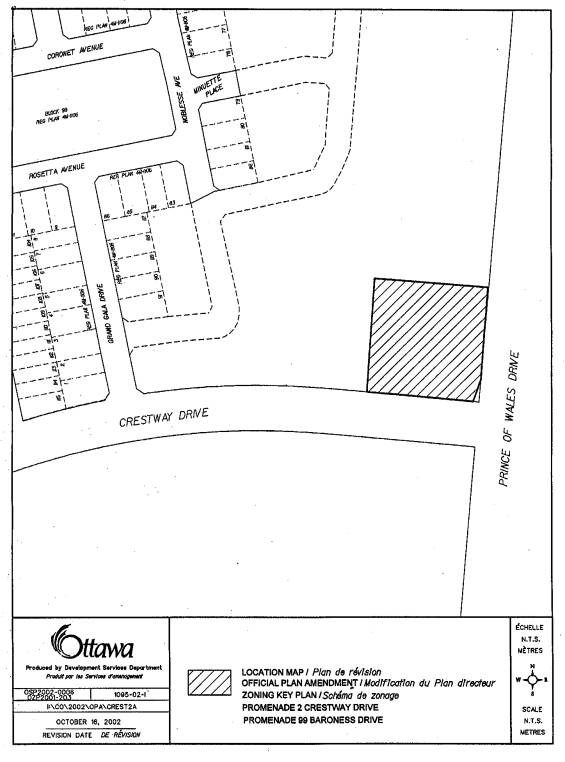
This property is
located on the northwest corner of the intersection of Crestway Drive and
Regional Road 73 also known as Prince of Wales Drive. The parcel of land has an area of approximately 0.56 hectares and
is currently vacant. The surrounding
area uses consist of a low-density residential area and open space, that has
been zoned “Conservation”, along the west side of Prince of Wales Drive.
Previous Subdivision and Zoning
Applications
The lands associated with this rezoning request are included in a larger
block identified on a draft plan of subdivision. Through the subdivision of these lands, it was staff’s position
in the former City of Nepean that the lands now under consideration for
rezoning were not developable. In the
absence of the City receiving an engineering study to address the
serviceability of these lands, the subdivision approval required that these
lands, together with the surrounding mentioned larger block of land, were to be
conveyed to the City upon registration of the subdivision. As a consequence of the subdivision approval,
through the related rezoning application these lands were also rezoned from FG,
Future Growth Zone, to CON, Conservation Zone. The intent of the CON Zone is to preserve
what may be the natural character of the land and to permit development of
future recreational uses such as pathway.
The rezoning of these lands was not appealed and is now final and
binding. To be consistent with overall
Official Plan’s Conservation Zone designation, Schedule “A” of a
Secondary Plan was also amended to a Greenway designation. The intention was that these lands be
conveyed to the City as open space with the registration of phase three of the
subdivision.
On April 23, 2002 the City received an engineering report prepared for
the applicant demonstrating that the parcel of land requested for the rezoning
can be serviced and is thereby developable.
In light of emerging engineering advancements described in the report,
staff is now in the position to accept the conclusions of the report enabling
staff to proceed in the consideration of the applicant’s Official Plan and
zoning amendment request. The applicant
also submitted a commercial market potential analysis dated April 4, 2003
regarding the suitability, attractiveness and market potential for this subject
site that supports the official plan and zoning amendment applications.
DISCUSSION
Applicable
former Region of Ottawa-Carleton and Nepean Official Plans
Prince of Wales Drive has been identified a “Scenic Route” within the
Region of Ottawa-Carleton Official Plan given its proximity to the Rideau River
and the fact that this is a major north-south route into the City. This Official Plan directs that the visual
character and impact of adjacent development along scenic routes must be
addressed in any development application.
Additionally, the Official Plan directs that opportunities be taken to
locate such elements as planting, and pathways in the consideration of any
development applications located along these corridors. In formulation of the applicable Secondary
Plan for Areas 4, 5 & 6, a Greenway designation was established along the
westerly and easterly side of Prince of Wales Drive. The purpose of this Greenway was to provide an open space network
that would serve as a passive recreational feature in the form of a pathway.
The Secondary Plan also gives regard to a hierarchy of street types
identifying Prince of Wales Drive as one of the primary north-south
routes. The roadway development plan
for that portion of the regional road sets out a number of requirements,
including the minimization of new intersections and the prohibiting of new
development in having direct vehicular access to the road. It is also the intention that a median be
constructed at the time of any reconstruction of this road in order to limit
left-turning vehicular movements to better facilitate uninterrupted traffic
flows. Once constructed, private
approaches for properties along that stretch of Prince of Wales Drive will only
have a right-in and right-out vehicular movements.
City
Council Approved New Official Plan
The New Official Plan identifies Prince of Wales Drive as Scenic-Entry Route and, similar to the former Regional Official Plan, promotes the landscaping, berming, pathways and other features within the right-of-way and onto adjacent lands. This plan also identifies a Major Recreational Pathway along Prince of Wales Drive promoting pathway connections utilizing greenspace features. The former City of Nepean Secondary Plan for this area has been adopted into the New Official Plan that identifies the subject lands as a Greenway.
Requested
Official Plan and Zoning Designations - Refusal
Tartan Land Corporation has requested that the Official Plan and Secondary Plan designations for this property be amended to a Residential designation and be rezoned CA3(CN), Commercial Automotive Zone. It is the applicant’s intention to development this property as an automobile service station with a restaurant as permitted by the requested zone designation. Additional permitted uses in the CA3 (CN) zone include a carwashing establishment and an automobile repair garage for minor repairs.
In order for
this type of business operation to be successful full vehicular movements on
Prince of Wales Drive and possibly Crestway Drive would be required. As such, it is the position of staff that
this particular zoning request is not consistent with the policy direction contained in the former
Region of Ottawa-Carleton and former City of Nepean Official Plans.
This inconsistency is further emphasized in the
City of Nepean’s Secondary Plan for this area that specifically indicates that
private approaches for new development along this portion of Prince of Wales
Drive shall not be allowed.
Additionally, the introduction of a commercial development of this
nature would impede the satisfactorily achievement of the former Regional and
City of Nepean design guidelines advocating the introduction of planting, and a conceptual pathway proposed along this
portion of Prince of Wales Drive.
The Secondary Plan, as enacted, discourages commercial activity to be located along Prince of Wales. It does however place an emphasis on locating commercial uses within the core of the new community. The development plan identified a “Mainstreet” that will be located within 400 metres, or a five minute walk, to significant portion of the residential community. “Mainstreet” is intended to include a broad mix of uses including commercial uses that provide a service at a community level. The requested amendments to allow commercial automotive service station was not envisioned to be part of neigbourhood fabric but to be located outside of the community along arterial roadways.
CONSULTATION
The public was consulted by application notification signs being posted on the subject property and by the mailing of notices to community organizations serving the area. The response to the circulation is detailed in Document 5.
FINANCIAL IMPLICATIONS
N/A
APPLICATION PROCESS TIMELINE STATUS
This application was not processed within the timeframe established for the processing of Official Plan and Zoning By-law Amendment applications owing to the technical complexities arising in the consideration of this application.
ATTACHMENTS
Document 1 Location Plan
Document 2 Consultation Details
DISPOSITION
City Clerk to notify the owners and the Manager of
Assessment, Corporate Services Department, of City Council’s decision.
LOCATION PLAN Document
1
CONSULTATION DETAILS Document
2
Councillor’s Comments
Councillor
Jan Harder is aware of this application.
Public Comments
Summary of Comments
Three comments from the community and one from a local developer with an interest in the area were received objecting to the proposed Official Plan and Zoning Amendment. The general sentiment is that these lands should remain part of the Greenway Plan complete with continuous landscaped boulevards, recreationally pathways and parkland as originally proposed in the plan of subdivision for this area. Should development be permit, it should be required to be of a similar design theme to that of the Havenlea Subdivision, buildings with peaked roofs and gables, and not just another cookie cutter commercial development. A second comment suggested it development were to be allowed that it be limited to low-density residential with a requirement to be well setback from Prince of Wales Drive.
Response
Alternative land uses to the commercial zoning request were not considered to be practical due to the limitations of the size and servicing constraints of this site.