2. Official plan,
zoning and draft plan of subdivision - 300 goulbourn forced road AND 535
goulbourn forced road
PLAN OFFICIEL, ZONAGE ET PLAN
DE LOTISSEMENT PRÉLIMINAIRE - 300 ET 535, CHEMIN GOULBOURN FORCED
|
COMMITTEE RECOMMENDATIONS AS AMENDED
That Council approve:
1. An amendment to the former City of
Kanata Official Plan to shift boundaries of current land-use designations of
300 Goulbourn Forced Road and 535 Goulbourn Forced Road, as shown in Document
3, as amended by the following:
To include Schedule B
to the Official Plan Amendment being an amendment to Schedule C of the Former
City of Kanata Official Plan.
2. An
amendment to remove the land at 300 Goulbourn Forced Road and 535 Goulbourn
Forced Road from the former March Township Zoning By-law No. 552 and amend
former City of Kanata Zoning By-law 167-93 to zone the land "Residential
Type 3A-10", "Residential Type 3A-9",
"Residential Type 6A-1", "General Commercial-1",
"Institutional-1" and Open Space-1" as detailed in Document 4.
3. The active park be reduced by three acres by sharing
parking and playing fields with the adjacent schools and that the three acres
of open space be added to the NEA lands north of the West Block.
4.
The Solandt Road connection be reflected in the Plan of Subdivision
until such time as a formal traffic study confirms that it is not required.
And that the necessary amendments be made to the Official Plan, Plan of
Subdivision and the zoning details. And
that no further notice be provided pursuant to Section 34(17) of the Planning Act.
RECOMMANDATIONS MODIFIÉes DU COMITÉ
Que le Conseil approuve :
1. La
modification du Plan officiel de l’ancienne Ville de Kanata de manière à
déplacer les limites des utilisations du sol au 300 et 535, chemin Goulbourn
Forced, comme l’illustre le document 3, sous réserve de la modification
suivante :
Inclure
l’annexe B de la modification du Plan official, soit une modification de
l’annexe C du Plan official de l’ancienne Ville de Kanata.
2. Une modification qui
soustrairait les terres situées au 300 et au 535, chemin Goulbourn Forced du
Règlement de zonage 552 de l’ancien Canton de March, modifierait le Règlement
de zonage 16793 de l’ancienne Ville de
Kanata et attribuerait aux terres visées les désignations zone résidentielle
type 3A7, zone résidentielle type
3A8, zone résidentielle type 6A1, zone commerciale générale1, zone institutionnelle1, zone d’espace libre1, comme l’explique en
détail le document 4.
3. Le retranchement de
trois acres du parc actif par le partage des terrains de stationnement et
de sport avec les écoles attenantes et l’ajout des trois acres d’espace
libre aux terrains de la zone écologique naturelle au nord du bloc ouest.
4. La représentation du
raccordement de la promenade Solandt dans le plan de lotissement jusqu’à
ce qu’une étude en règle de la circulation confirme qu’il n’est pas requis.
Que le
Plan officiel, le plan de lotissement et les particularités du zonage soient
modifiés en conséquence. Qu’aucun autre avis ne soit donné aux termes du paragraphe 34(17)
de la Loi sur l’aménagement du territoire.
For the information of council
The Committee approved the following Motion in conjunction with the
staff recommendation:
Direct
staff to investigate the following Motion and report back before the matter
rises to Council:
That the incursion into City owned NEA lands
by the Terry Fox Drive extension be traded with the developer for equivalent
forested lands within the development (six acres)
Pour
la gouverne du Conseil
Le Comité a approuvé la motion suivante
compte tenu de la recommandation du personnel :
Charger
le personnel de faire enquête sur la motion suivante et de faire rapport de ses
constatations avant que le Conseil se penche sur la question :
Que la
partie des terrains de la zone écologique naturelle qui appartiennent à la
Ville sur laquelle empiétera le prolongement de la promenade Terry-Fox soit
échangée contre des terrains boisés équivalents appartenant au promoteur à
l’intérieur du secteur à aménager (six acres).
Documentation
1. Development Services
Department General Manager’s report dated 13 April 2004
(ACS2004-DEV-APR-0054).
2.
Extract
of Draft Minutes, 11 May 2004.
Report to/Rapport au :
Planning and Environment Committee
Comité de l'urbanisme et de
l'environnement
and Council / et au Conseil
13 April 2004 / le 13 avril 2004
Submitted by/Soumis par : Ned Lathrop, General Manager/Directeur général,
Development
Services/Services d'aménagement
Contact Person/Personne
ressource : Grant Lindsay, Manager / Gestionnaire
Development Approvals / Approbation des demandes
d’aménagement
(613) 580-2424 x13242, Grant.Lindsay@ottawa.ca
|
|
Ref N°: ACS2004-DEV-APR-0054
|
|
SUBJECT:
|
Official plan, zoning and draft plan
of subdivision - 300 goulbourn forced road and 535 goulbourn forced road
|
|
|
|
|
OBJET :
|
PLAN OFFICIEL, ZONAGE ET PLAN DE LOTISSEMENT
PRÉLIMINAIRE – 300 ET 535, CHEMIN GOULBOURN FORCED
|
REPORT RECOMMENDATIONS
That the Planning and Environment
Committee:
1. Recommend Council approve an amendment
to the former City of Kanata Official Plan to shift boundaries of current
land-use designations of 300 Goulbourn Forced Road and 535 Goulbourn Forced
Road, as shown in Document 3.
2. Recommend Council approve an amendment
to remove the land at 300 Goulbourn Forced Road and 535 Goulbourn Forced Road
from the former March Township Zoning By-law No. 552 and amend former City of Kanata
Zoning By-law 167-93 to zone the land "Residential Type 3A-7",
"Residential Type 3A-8", "Residential Type 6A-1",
"General Commercial-1", "Institutional-1" and Open
Space-1" as detailed in Document 4.
3. Authorize the Director of Planning and
Infrastructure Approvals to grant draft plan approval to the proposed Draft
Plan of Subdivision shown in Document 5, and subject to the Draft Plan
Conditions detailed in Document 7.
RECOMMANDATIONS DU RAPPORT
Que le Comité de l’urbanisme et de l’environnement :
1. recommande au Conseil d’approuver une
modification au Plan officiel de l’ancienne Ville de Kanata de manière à
déplacer les limites des utilisations du sol actuelles au 300 et au 535, chemin
Goulbourn Forced, comme l’illustre le document 3.
2. recommande au Conseil
d’approuver une modification qui soustrairait les terres situées au 300 et au
535, chemin Goulbourn Forced du Règlement de zonage 552 de l’ancien Canton de
March, modifierait le Règlement de zonage 16793 de l’ancienne Ville de Kanata et attribuerait aux terres visées les
désignations zone résidentielle type 3A7, zone résidentielle type 3A8, zone résidentielle type 6A1, zone commerciale générale1, zone institutionnelle1, zone d’espace libre1, comme l’explique en détail le document 4.
3. autorise le directeur, Approbation des
demandes d’urbanisme et d’infrastructure, à approuver le projet de plan de
lotissement préliminaire présenté au document 5, dont le détail est expliqué au
document 7, sous réserve des conditions applicables audit plan préliminaire.
EXECUTIVE SUMMARY
Assumptions and Analysis:
The
applications propose the layout of the remaining undeveloped land within the
Marchwood-Lakeside Community, covering an area of approximately 269
hectares. The lands were designated for
urban development by order of the Ontario Municipal Board in January,
1983. The current proposal includes a
wide range of land uses, including a mix of residential densities, institutional
uses, open space, commercial uses and natural environment areas (referred to as
“Environmental Protection Area” by the former Kanata Official Plan). This subdivision proposal is atypical of
most such applications due to the legal requirement for 40% of the land area to
be designated for “open space” purposes.
Existing
residential development abuts the subject lands to the south, east and
north. Residents of these communities
and elsewhere have enjoyed use of the subject lands as a natural recreational
area for more than twenty years. The lands
form part of the Canadian Shield, are largely forested, and contain wetland
pockets and rock outcrops. Well-used
recreational trails cover most of the subject land.
The
currently proposed subdivision would replace much of the forested area with
residential development. Consequently,
the community has expressed a great deal of opposition to the subdivision
layout as it was submitted and proposed in June, 2003. The magnitude of community concern became
evident at the Community Information Session, held in September 2003, at which
approximately 600 people, expressed their wish to maintain the forests and
pathways in their current state. Due to
the magnitude of community concern, review of the proposal became a highly
interactive process between staff, the applicant, community representatives and
the Ward Councillor.
The
primary matter of discussion has been the 40% agreement, and identification of
the lands to be dedicated as “open space” under the definitions contained
within the agreement. The plan has been
modified from its original submission through Plans “A”, “B”, and “C”. Version “D” was proposed by the community
and finally, Plan ‘H’, is supported by staff and contained in Document 5 (Plans
A and B) as the final proposed Draft Plan of Subdivision. The proposed draft plan is of a size that
necessitates two separate plans.
Public Consultation/Input:
Since
its submission in June, 2003, the plan(s) has been presented and discussed with
community associations and the public in numerous venues. Various forms of formal public meetings and
focus group sessions were held in September and December 2003, as well as
February and April, 2004.
Generally,
the public view is to preserve as much of the land north of the Beaver Pond as
possible. Community groups have put
forth suggestions that much of these lands, which are currently designated for
residential development by the former Kanata Official Plan, be traded for other
lands which are either currently designated as “Open Space”, or proposed to be
designated as “Open Space” under Plan ‘H’.
The community suggests that locally significant wetlands, fish habitat,
active recreational space (soccer pitches), the clear-cut lands for which
compensation land has been offered, and other natural environment areas and
buffers be developed as a trade-off for preserving more of the lands located
north of the Beaver Pond.
Planning
staff has investigated the community’s recommendations with a view to balancing
the desire of the existing adjacent communities with the needs of the future
community, and the acceptance of such changes to the landowner. The landowner currently enjoys the right to
develop the land by virtue of its current Official Plan designation. To suggest alternatives that would significantly
increase their cost of development may result in the owner appealing the
applications to the Ontario Municipal Board, where their current development
rights would likely be maintained.
The matter
of “Open Space” allocation is further complicated by a relative shortfall in
the area that can be designated as open space.
The boundaries of the “Environmental Protection Area” contained within
the three Official Plans are now compromised and reduced in area as a result of
the implementation of the 40% agreement.
The shortfall is the result of an over-dedication of approximately 7.3
hectares of 40% open space through registration of earlier subdivisions. In addition, new environmental areas now
qualify for allocation under the 40% agreement. For example, the requirement to protect fish habitat pre-dates
the 40% agreement. However, as a
natural feature, Shirley’s Brook, which contains fish habitat, must now be
protected and dedicated under the 40% agreement.
Staff are
recommending approval of Plan ‘H’, which designates a larger area of open space
north of the Beaver Pond than was proposed by the 1990 concept plan and is
currently designated by the three applicable Official Plans. The area that is most compromised by Plan
‘H’ is a section of Kizell Pond, known as the “west block”, consisting of a
mature beech forest. Due to the net
shortfall in 40% open space area, approximately two-thirds of this beech forest
(west block) will be redesignated from “Environmental Protection Area” to “Low”
and “Medium-Density Residential” land use designations.
RÉSUMÉ
Hypothèses et analyse :
Les
demandes visent à fixer la disposition des terres non aménagées, d’une
superficie d’environ 269 hectares, de la communauté de Marchwood-Lakeside.
L’aménagement urbain des terres visées est prévu par une ordonnance rendue par
la Commission des affaires municipales de l’Ontario en janvier 1983. La
proposition actuelle prévoit un large éventail d’utilisations du sol, notamment
un assortiment d’utilisations résidentielles de densités variées, des
utilisations institutionnelles, des espaces libres, des utilisations
commerciales et des aires environnementales naturelles (appelées « aires
de protection environnementale » dans le Plan officiel de l’ancienne ville
de Kanata). La présente demande de lotissement a ceci de particulier qu’elle
est soumise à une exigence légale selon laquelle 40 % de la superficie des
terres doit être désigné « espace libre ».
Des
aménagements résidentiels sont contigus aux terres visées, au sud, à l’est et
au nord. Les résidents de ces quartiers et d’ailleurs profitent des terres
visées en tant qu’aires récréatives naturelles depuis plus de 20 ans. Les
terres en question font partie du Bouclier canadien, sont en grande partie
boisées et comportent des enclaves de terres humides et des affleurements
rocheux. Des sentiers récréatifs achalandés fortement fréquentés les
sillonnent.
La
demande de lotissement aurait pour effet l’aménagement résidentiel d’une part
importante des terres boisées. Par conséquent, la collectivité s’est opposée
fortement au plan de lotissement présenté en juin 2003. L’ampleur des
préoccupations de la population est devenue évidente à l’occasion de la séance
d’information communautaire tenue en septembre 2003, auquel moment environ
600 personnes ont dit vouloir préserver les forêts et les sentiers.
L’importance des préoccupations exprimées par la collectivité a fait du
processus d’examen de la demande une démarche fortement interactive à laquelle
ont participé le personnel, le requérant, des représentants de la collectivité
et le conseiller du quartier.
Les
discussions ont porté principalement sur l’accord éventuel prévoyant le
maintien de 40 % d’espace libre et la détermination des terres à désigner
ainsi aux termes des définitions contenues dans ledit accord. Le plan a été
modifié plusieurs fois, et des versions A, B et C ont été présentées. La
version D a été proposée à la collectivité, et, finalement, le personnel a
accordé son appui à la version H, contenue dans le document 5
(plans A et B), qui représente le projet final de plan de lotissement
préliminaire. Le projet de plan préliminaire est illustré par deux schémas
distincts en raison de sa grande taille.
Consultation publique/commentaires :
Depuis
leur présentation en juin 2003, les plans ont été soumis à l’examen
d’associations communautaires et du public et discutés avec eux à de nombreux
endroits. Divers types de réunions publiques officielles et de séances de
groupes de ciblage ont eu lieu en septembre et décembre 2003, aussi bien
qu’en février et avril 2004.
Le
public souhaite généralement préserver la plus grande superficie possible au
nord de l’étang de castors. Des groupes communautaires ont proposé qu’une part
importante des terres visées que le Plan officiel de l’ancienne Ville de Kanata
destine à l’aménagement résidentiel soient échangées contre d’autres qui sont
déjà désignées espace libre ou dont la désignation comme tel est proposée en
vertu du plan H. La communauté a proposé que des terres humides d’importance
locale, des habitats de poissons, des aires récréatives à usage actif (terrains
de soccer), des terres coupées à blanc pour lesquelles des terres de
substitution ont été offertes, d’autres aires environnementales naturelles et
des zones tampons soient aménagés en échange de la préservation d’une
superficie accrue des terres situées au nord de l’étang de castors.
Les
urbanistes ont fait enquête sur les recommandations du public en vue de
concilier les vœux des collectivités contiguës et les besoins de la future
collectivité, aussi bien que de maximiser les chances que les changements
proposés soient acceptés par le propriétaire. Ce dernier est actuellement
autorisé à aménager les terres visées en vertu de leur désignation dans le Plan
officiel. Si les solutions de rechange proposées devaient augmenter de manière
appréciable le coût de l’aménagement, le propriétaire pourrait en appeler des
décisions rendues en ce sens à la Commission des affaires municipales de
l’Ontario, qui, vraisemblablement, reconnaîtrait les droits d’aménagement en
vigueur.
La
détermination de la part des terres à désigner espace libre est compliquée par
l’insuffisance relative de la superficie susceptible d’être désignée comme tel.
Les limites de l’aire de protection environnementale prévues dans les trois
plans officiels sont désormais compromises, et la superficie de l’aire est
réduite à cause du principe de l’attribution de la désignation espace libre à
une part de 40 % des terres dont l’aménagement est proposé. En effet, l’insuffisance
s’explique par la désignation excessive de 7,3 hectares à titre de part de
40 % d’espace libre par suite de l’enregistrement de plans de lotissement
antérieurs. De plus, de nouvelles aires environnementales sont désormais
susceptibles d’être désignées aux termes d’accords dits « de
40 % ». À titre d’exemple, l’obligation de protéger les habitats de
poissons est antérieure aux accords de 40 %. Cependant, comme il s’agit
d’une caractéristique naturelle, le ruisseau Shirley, qui renferme des habitats
de poissons, doit désormais être protégé et désigné en vertu de l’accord de
40 %.
Le
personnel recommande l’approbation du plan H, qui désigne une superficie
d’espace libre au nord de l’étang de castors supérieure à ce qui avait été
proposé dans le plan conceptuel de 1990, laquelle superficie est actuellement
désignée comme tel par les trois plans officiels pertinents. Le secteur menacé
le plus par le plan H est une partie du secteur de l’étang Kizell, appelée
« bloc de l’ouest », qui consiste en une forêt de hêtres adultes. À
cause de l’insuffisance nette de la superficie de 40 % d’espace libre, la
désignation aire de protection environnementale des deux tiers environ de la
forêt de hêtres (bloc de l’ouest) sera remplacée par les désignations zone résidentielle
de faible densité et zone résidentielle de densité moyenne.
BACKGROUND
The Applications:
The City has received three development
applications relating to a 269-hectare parcel of land. The application to amend the former Kanata
Official Plan proposes to modify the boundaries of specific land use
designations that were adopted in 1990.
The Zoning By-law Amendment will implement the proposed Official Plan
designations, as the lands are currently not zoned for urban development. The City has also received an application
for Draft Plan of Subdivision approval.
The Ward Councilor has exercised the discretion to remove delegated
authority from staff.
The lands subject to the applications are
located to the north of existing development in the Marchwood-Lakeside
Community (also known as Kanata Lakes).
The subject land straddles the Kizell Pond and runs north of the Beaver
Pond where it meets the Morgan’s Grant Community and the future Terry Fox Drive
extension. The western limit is the unopened
First Line Road allowance and the eastern limit abuts the Kanata North Business
Park. The lands are currently
undeveloped and are covered by forest, Canadian Shield rock outcropping and
locally significant wetlands. Goulbourn
Forced Road, currently constructed to a rural standard, bisects the land. For planning purposes, the
Marchwood-Lakeside Community is made up of Marchwood, which is planned to
contain four neighbourhoods, and Lakeside, which is planned to contain three
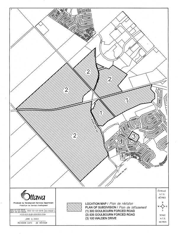
neighbourhoods. A Location Map is shown
as Document 1.
In 1981, the City of Kanata entered into a
legal agreement with the landowner of the time which required 40% of the total
land area (566.5 hectares at that time) to be designated as “Open Space”. In return, the City would support the
landowner’s application to designate the land for urban development. The decision to designate the land for urban
development was rendered in 1983 by the Ontario Municipal Board, and the 40%
Agreement continues to remain registered on title. Based on a total land area of 566.5 hectares, the 40% agreement
requires that a total of 226.6 hectares be allocated as “Open Space”.
The 1981 40% agreement, amended in 1988,
defines the applicable 40% lands as including the 18-hole golf course,
stormwater management areas, natural environment areas and land to be used for
park purposes. To date, a Surveyor’s
Certificate certifies that 119.08 hectares of land have already been provided
under the 40% agreement through registration of previous subdivisions, leaving
107.55 hectares to be dedicated and designated through the current
applications.
As a condition of the development approvals
granted in 1983, the landowner was required to submit a concept plan of the
entire development. This concept plan
formed the basis of the current Kanata Official Plan designations, which were
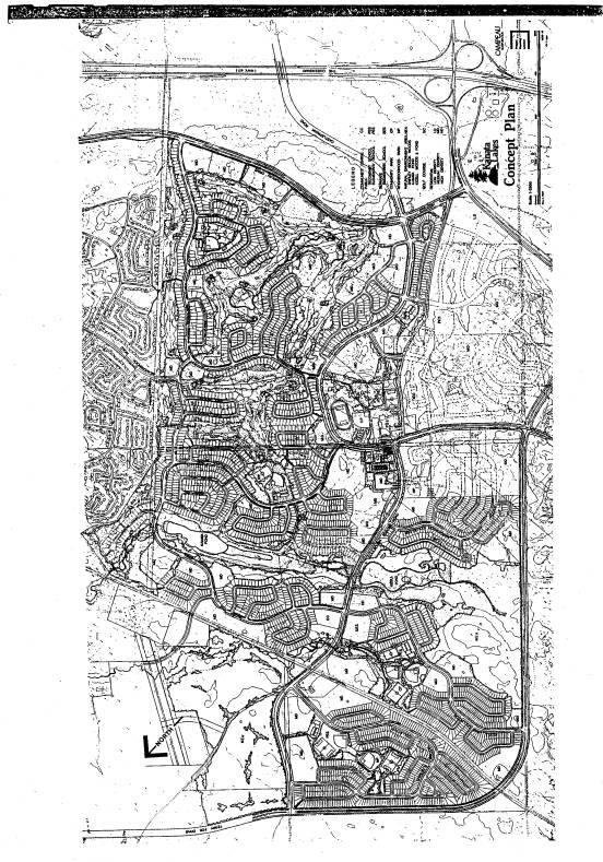
adopted in 1990. The concept plan,
shown at Document 2, reflects the form and location of development that is
presently permitted by the applicable Official Plans. The current proposal represents a relatively minor deviation from
the 1988 concept plan.
DISCUSSION
Council Approved Official Plan
The Growth Management strategies of the new Official Plan
provide that growth will occur by directing it to the urban area. Environmental integrity will be maintained
by conserving provincially and locally significant wetlands, maintaining
ecosystems functions and protecting greenspaces. The subject applications are consistent with this strategic
direction.
Within the Plan, Section 3 -“Plan Designations and Land
Use” contains policies pertaining to the natural environment and the “Urban
Natural Features” designation that applies to Trillium Woods, Kizell Pond and
Beaver Pond. The Official Plan policies
apply this designation to woodlands, wetlands, watercourses, and ravines and
describe the permitted uses as including open air recreation, scientific,
educational or conservation uses.
The proposed Kanata Official Plan amendment and Zoning
By-law amendment comply with the policies contained in Section 4.7 of the Plan,
“Environmental Objectives”. The
objective to increase forest cover is met by maintaining as much of the most
environmentally valuable land as possible.
Also consistent with the objective of protecting and improving the
habitat for fish and wildlife in stream corridors, Shirley’s Brook and a 30
metre buffer will be protected by applying an “Open Space” designation under
the Draft Kanata Official Plan amendment.
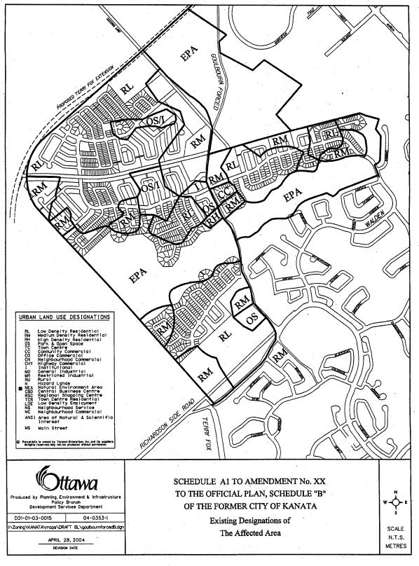
The Plan designates the land as “General Urban Area” and
“Urban Natural Feature”. The latter
designation applies to Trillium Woods, Kizell Pond and Beaver Pond. The minor boundary change to the “Urban
Natural Feature” area proposed does not necessitate an Official Plan Amendment
to the City of Ottawa Official Plan.
The applicable policy states “the boundaries of land designated Urban
Natural Features are based on a variety of detailed mapping sources…..However,
when more detailed environmental studies are completed, this additional
information may require minor adjustments in the definition of features and
functions and the interpretation of the boundary. It is not intended that these
minor adjustments will require amendment to this Plan”.
The City of Ottawa Official Plan is currently under
appeal. Therefore, the applications are
subject to the policies of the Regional Official Plan and Kanata Official Plan.
Former Regional Official Plan (ROP) Designation
The subject lands are designated "General Urban
Area" and "Natural Environment Area-A" by the former Regional
Official Plan. The "General Urban
Area" designation permits residential uses, as well as community
facilities, retail uses and service commercial uses.
The areas that form part of the Trillium Woods, as well as
Kizell Pond and Beaver Pond are designated "Natural Environment
Area-A". The "Natural
Environment Area" designation is intended to protect significant natural
areas. However, the Plan recognizes
that the boundaries of this designation may be interpreted differently without
amending the plan, based on more detailed studies.
The proposed Draft Plan of Subdivision therefore conforms
with both the "General Urban Area" and "Natural Environment
Area-A'" designations of the Regional Official Plan. An amendment to the Plan is not required.
Former Kanata Official Plan Amendment
The current Official Plan policies that apply to all of the
Marchwood-Lakeside Community, including the subject lands, require that a total
population of 23000 people be accommodated within the overall community at full
build-out. The targets are set at
achieving a population of 14000 in Marchwood and 9000 people in Lakeside. The current population is approximately
9700.
The subject proposal provides for 3248 dwelling units, with
332 of these completing the Marchwood Community and 2916 units to be developed
within the three planned neighbourhoods of the Lakeside Community. It is therefore anticipated that population
targets will come close to those set within the existing Kanata Official Plan
policies, providing for approximately 13000 people in Marchwood and 8000 in
Lakeside.
In order to implement the proposed plan of subdivision,
changes to the Kanata Official Plan are proposed which affect the policies, as
well as the land use designations shown on Schedule ‘B’ – “Urban Land Use
Designations”. The Draft Official Plan
amendment is contained in Document 3.
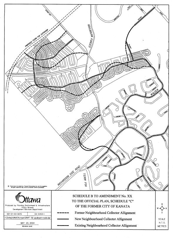
Schedule changes will adjust the boundaries of residential
designations, move school, park and commercial sites and re-align certain
collector streets. Policy amendments
are also proposed, reducing the minimum lot size for the commercial use and
de-centralizing the location of schools and parks. The proposed Draft Plan of Subdivision would result in a slightly
lower housing yield and population than what is currently targeted within the
Kanata Official Plan for the Marchwood and Lakeside Communities. The OPA will therefore encourage densities
to be increased wherever possible by assigning a dual “Low Density/Medium
Density” designation where lotting for singles is proposed by the Draft Plan,
and will increase the maximum permitted density within the “Residential High
Density” designation.
The amendment will provide for the deletion the Walden
Drive connection to Terry Fox Drive, through the Special Study Area lands. It will also provide for the potential
deletion of the connection of Solandt Road between the lands north of the
Beaver Pond and the Kanata North Business Park, subject to approval of an
acceptable Transportation Impact Study and provision of alternate access to
development lands in the Kanata North Business Park. This requirement will also be included as a condition of Draft
Plan of Subdivision approval.
Similarly, Official Plan policies regarding the phasing of road
construction are deleted. Such requirements
are more appropriately implemented through conditions of draft plan approval,
and are listed in the conditions provided in Document 7.
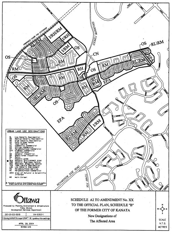
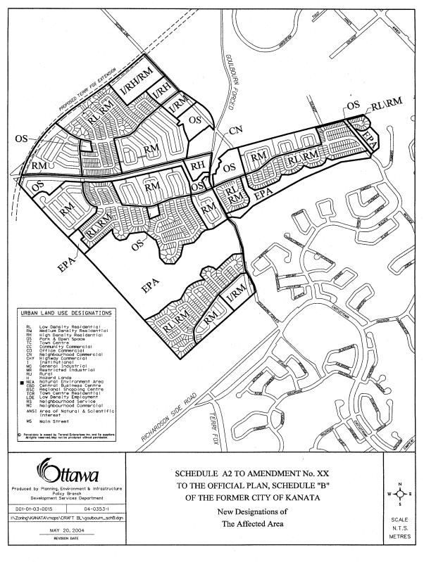
The amendment to Schedule ‘B’ – “Urban Land Use
Designations” will alter the boundary of the current “EPA” lands. The boundary of the “Environmental
Protection Area” (EPA) north of the Beaver Pond remains relatively unchanged,
with the exception of the loss of a small amount of open space west of Kimmins
Court and the addition of a 40 metre wide corridor connecting the Beaver Pond
forested area to Trillium Woods to the north.
Also, Shirley’s Brook, along with its required 30 metre buffer and a
small active park providing a mini soccer pitch and tot lot are added at the southeast
intersection of Goulbourn Forced road and the rail right-of-way. The “EPA” lands on the west side of
Goulbourn Forced Road at Kizell Pond/west block are decreased along the
northern edge where this boundary has been shifted to the south. This is the
area of greatest change between the current “EPA” boundary and the proposed new
boundary, compromising some of the west block/beech forest. The designation of Trillium Woods as “EPA”
remains unchanged.
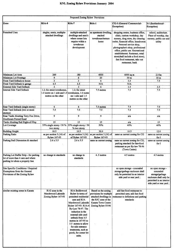
Zoning By-law Amendment
The land has been designated for urban development since
1983. However, an implementing zoning
by-law amendment has not yet been passed.
The subject lands are currently not zoned for urban development and are
zoned “Rural” by an old March Township Zoning By-Law No. 552. The proposed zone provisions prescribe development
standards for single-detached, semi-detached, townhouse and apartment
development. These are similar in
nature to the most current forms of residential development, using reduced,
less land-consumptive standards. The
typical front and exterior side yard setbacks for Marchwood Development have
been 4.5 metres, with a 7.5 metre rear yards.
The proposed Zoning By-law employs 4.5 metres setbacks for garages,
reduced to 3.0 metres for the dwelling.
This can provide for a more pleasing streetscape of recessed
garages. Rear yards will be reduced to
6.0 metres for one-storey dwellings, but increased to 15 metres where a yard
abuts the rail right-of-way. Overall
building coverage is increased from 40% to 55% for single-storey and 50% for
two-storey units. This is consistent
with Zoning By-laws in various growth areas of the city. Zone provisions for commercial and
institutional uses have also been adjusted to be consistent with those
standards currently used throughout the City.
Despite the draft plan showing single-lots, the applicable zoning will
also permit semi-detached and townhouse dwellings. This will allow the development densities to be increased more
easily and facilitate meeting population targets for the Marchwood-Lakeside
Community. Document 4 contains a table
outlining the proposed zone provisions, as well as a Zoning By-law Schedule.
Rationale:
Planning Policy Context and Conformity
Currently, the three relevant Official Plans, being Kanata,
the Region and the new City of Ottawa Plan, designate Trillium Woods, Beaver
Pond and Kizell Pond, as well as forested area north of Kizell Pond (west
block) as “Environmental Protection Area” (EPA), “Natural Environment Area – A”
(NEA-A) and “Urban Natural Feature” (UNF), respectively. All designations generally have the
intention of protecting the environmental value and integrity of the natural
area. The three Official Plans also
acknowledge that the boundary of the natural area may be further defined through
the plan of subdivision process, field studies or other further study. The current applications and Draft Kanata
OPA define the final natural area boundary.
It is important to note that the three natural features within the
subject lands (Trillium Woods, Beaver Pond and Kizell Pond/west block)
constitute all of the “Urban Natural Features” designation within the former
City of Kanata. This natural
environment area is therefore intended to serve the whole Kanata community, and
not just the immediate and adjacent neighbourhoods.
The proposed Draft Plan, attached as Document 5 (A and B)
has been modified numerous times since its submission as an application in
June, 2003. Staff is recommending
approval of this plan (called Plan/Alternative ‘H’) and its associated Draft
Official Plan amendment and Zoning By-law amendment.
Ratio of low, medium, high
residential
The subdivision plan proposes the development of over 3200
dwellings. Of these, nearly 54%
represent medium density townhouse development. High density residential development represents 11% of the
dwellings proposes, while low-density single-detached development makes up the
remaining 35%. The new Official Plan
encourages higher density development such as this, as well as the use of
alternative development standards to assist in providing more affordable
housing. The proposed Zoning By-law
amendment implements reduced setbacks and the use of some alternative
development standards.
School Blocks
The proposed draft plan of subdivision contains one
separate elementary school site within the final (4th) Marchwood
neighbourhood. Within the three
Lakeside neighbourhoods, two elementary schools and one high school site are
proposed to be grouped together north of Kizell Pond, along the west side of
Goulbourn Forced Road, opposite Trillium Park.
The schools are also in proximity to the 5.4-hectare active City park,
planned to provide four full size soccer pitches. The school boards have provided their concurrence on the proposed
sites. These sites are designated and
zoned “Institutional” in the draft OPA and Zoning By-law Amendment.
City Parks
The Planning Act permits the municipality to take up to 5%
of the total land area as parkland dedication.
With a total land area of 269 hectares, 13.45 hectares could be
dedicated for parkland purposes through a typical subdivision approval
process. However, based on the
provisions of the 40% Agreement, more than 107 hectares will be dedicated as
open space through the subdivision development. The areas of active parkland will be designated as “Open Space”
and Zoned “Open Space-1”, while the natural environment areas are designated
“Environmental Protection Area” (EPA) by the Kanata Official Plan and also
zoned “OS-1”.
The proposed draft plan provides approximately 8.5 hectares
of active parkland, including a 5.4-hectare community park, providing four
playing fields. A Park Facilities
Program Update: Kanata Lakes North
Neighbourhood (November, 2002) indicates a need for soccer fields due to the
growth in popularity of the sport, and a lack of playing fields in the
vicinity. Additionally, each of the
three Lakeside neighbourhoods are provided with a neighbourhood park, each
having an area ranging from 0.48 hectares to 1.2 hectares. The remaining 5 hectares of parkland that
would normally by dedicated under the Planning Act are essentially transferred
to the “EPA” designation.
Servicing
Servicing of the proposed subdivision will be developed in
four phases, the first phase being immediately north of Kanata Avenue, and west
of Goulbourn Forced Road. Development
of this neighbourhood will complete development within the Marchwood
Community. The second phase of
development will extend the sanitary sewer from the hydro corridor at the north
end of Kimmins Court, and trunk watermain from the northeast end of the Beaver
Pond. Generally, stormwater is
channeled to Beaver Pond for development on the east side of Goulbourn Forced
Road, and to Kizell Pond for development on the west side of Goulbourn Forced
Road. The realigned Shirley’s Brook
will also receive stormwater runoff.
The third phase of development consists of the neighbourhood located
between Kizell Pond and the Rail line.
The last phase is located north of the rail line, west of Goulbourn
Forced Road and south of Terry Fox Drive.
Capacity is not a concern as the proposed draft plan of
subdivision contains densities and land uses similar to those proposed in the
original concept plan. When the
existing trunk sewers and watermains that will service this development were
designed through previous subdivision development, capacity was provided for
the subject lands.
Transportation
In 1985, the landowner of the time completed a
Transportation Study for the Marchwood-Lakeside Community which was based on
the concept plan shown as Document 2. The 1985 study was based on a unit count of more than 3700
dwellings and was approved by Kanata City Council. As part of the current planning submissions, the applicant has provided
a revised Transportation Impact Study to update the earlier study and to
address the minor changes between the transportation network of the original
concept plan and the currently proposed Draft Plan of Subdivision, containing
approximately 3200 dwellings.
Two of the more considerable changes proposed to the
transportation network since 1985 are the deletion of the Walden Drive
connection to future Terry Fox Drive to the west, and the deletion of the
Solandt Road connection between the Beaver Pond north neighbourhood and the
Kanata North Business Park.
The proposed amendment to the Kanata Official Plan will
allow for the possible deletion of the Solandt Road connection from Walden
Drive north of Beaver Pond to the Kanata North Business Park. Deletion of this connection will be conditional
upon the City’s acceptance and approval of a further Transportation Impact
Study. The City will also need to
consider the provision of an alternate means of access to development lands
that would have been served by the Solandt Road extension. These requirements are contained within the
subdivision conditions of Draft Plan Approval.
In addition, the Kanata Official Plan and the new Official
Plan show the Walden Drive collector as extending westerly, through the Special
Study Area (lands between the future Terry Fox Drive and the unopened First
Line Road allowance) and connecting to future Terry Fox Drive. The Draft Official Plan Amendment deletes
this connection in order to maintain the environmental integrity of the Special
Study/Natural Environment Area lands.
Rail Right-of-Way
The former CN Railway line runs diagonally through the
proposed subdivision. The right-of-way
is owned by the City, and was originally purchased by the former Region of
Ottawa-Carleton as part of its initiative to protect abandoned rail
rights-of-way for future commuter rail service. The City currently leases use of the right-of-way to a
manufacturer in Arnprior who makes one or more round trips per week on the
line, employing trains operated by Ottawa-Central Railway (OCR).
Consistent with policies of the new City of Ottawa Official
Plan, the rail line will remain protected for use as a future transportation
corridor. Section 2 – Strategic
Directions, states that the City will purchase surplus railway rights-of-way
corridors for use as future transportation and utility corridors. When such rights-of-way are acquired,
recreational and agricultural uses may be permitted as interim uses. The Plan further states that future use as a
transportation or utility corridor will have priority over any interim use.
In this case, the line remains active; therefore the
right-of-way is not proposed to be used for recreational purposes through the
subdivision approval process. Because
it is not proposed to be used as a recreational corridor, it will not be
designated as Open Space. The zoning
by-law will require deeper 15 metre setbacks for yards where residential lots
abut the rail right-of-way. The
developer is required to install 1.2 metre high black vinyl-coated chain link
fence along the rail right-of-way for safety purposes. Noise abatement will be implemented when
necessary through the construction of noise walls. At the current usage of one train per week, noise walls are not
necessary. Under a light-rail scenario,
they would likely be required. The
draft plan conditions include a notice on title to all purchasers of the
potential for light rail along this corridor, in addition to the standard noise
warning clauses.
Shirley’s Brook
An emerging environmental issue that was not addressed in
the 1990 Kanata Official Plan is the presence of Shirley’s Brook west of
Goulbourn Forced Road. The Council
approved Shirley’s Brook, Watt’s Creek Subwatershed Study (September, 1999)
requires the protection of Shirley’s Brook, using a 30 metre wide buffer. The brook is situated within the development
area north of the Kizell Pond EPA.
Shirley’s Brook has been identified as fish habitat along its entire
length within the subdivision area.
Under the Federal Fisheries Act, Shirley’s Brook must be protected. Since Shirley’s Brook is an environmental
feature, the area required to protect this natural resource is included within
the “open space” definition of the 40% agreement and is designated as “Open
Space” by the draft OPA.
Pedestrian pathway linkages have been added along the
length of Shirley’s Brook inside the buffer area to create continuous
connections between the larger EPA areas of Trillium Woods, Beaver Pond and
Kizell Pond and the extension of the South March Highlands in the Special Study
Area, west of First Line Road.
Environmental Protection
Area, Green Linkages and the 40% Agreement
Earlier subdivision approvals and excess 40% land
dedication from the original land holding has left the balance of 40% lands
somewhat short in comparison with what is currently designated by the existing
Official Plans. That is, the lands
shown as “EPA”, “NEA-A” and “UNF” will be reduced in scale through the final
subdivision approval because the remaining 107.25 hectares of open space must
be divided among stormwater management, active parks, stream protection and
buffers, wetlands, woodlands, greenspace linkages and pathways, and Trillium
Woods. Some of these areas were not
included in the existing “EPA” designations of the current Official Plans. In addition, approximately 7 hectares of
excess Open Space (40% land) has been dedicated through the registration of
previous subdivisions. The proposed
plan of subdivision results in a net shortfall of open space mainly in the
Kizell Pond/West Block area of approximately 7.29 hectares compared to what is
currently designated by the three Official Plans.
The boundaries of the natural environment area (EPA) have
been defined through the subdivision approval process. Green linkages have also been added as “EPA”
to create a pedestrian-oriented recreational pathway system that links the
various natural areas (Beaver Pond, Kizell Pond, Trillium Woods, South March
Highlands). This exercise, and approval
of the draft plan of subdivision complete the allocation of the remaining
107.25 hectares of open space lands required under the 40% agreement.
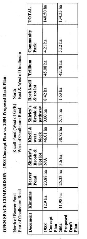
Document 8 is a comparative table that provides a break
down of land areas designated as “open space”.
The comparison shows the land area based on the 1990 concept plan, which
was the basis for the current Official Plan designation, versus the proposed
Draft Plan shown in Document 5. The
table indicates that the “Open Space” lands north of the Beaver Pond will
increase in size, while the Kizell Pond and west block area will be decreased
from what is currently designated for protection. The Environmental Implications section of this report describes
the methodology and consultation process whereby the fulfillment of the open
space agreement as shown on the draft plan was determined.
Conclusions
In conclusion, staff support the approval of the Draft Plan
of Subdivision and implementing Zoning and Official Plan designations as
detailed in this report. The proposed
draft plan balances existing and future community needs and respects the
principles of the original open space agreement and existing land use
designations.
ENVIRONMENTAL
IMPLICATIONS
The “NEA” and “EPA” designations conceptually defined
on Schedule B of the former Regional and Kanata Official Plans was the starting
point for the definition of the natural area boundaries. In 2002, the City and landowner jointly
commissioned ESG International Consulting Services to determine the boundaries
of the conceptually defined Natural Environment Areas (NEA's) and the Shirley’s
Brook watercourse within the Kanata Lakes development. Trillium Woods was excluded from this
exercise as the boundaries are defined by development to the east, Terry Fox
Drive to the north, the railway corridor to the south and the future alignment
of Goulbourn Forced Road to the west.
The exact northern boundary will be determined through the detailed
design of Terry Fox Drive.
The boundary delineation of the Kizell Pond and Beaver Pond
natural areas needed to consider:
·
Environmental criteria;
·
Stormwater Management requirements;
·
Recreational Requirements; and,
·
The 40% Open Space Agreement.
Policy 5.3.5.1 of the former Kanata Official Plan states,
“The Natural Environment Area includes sites where landforms, vegetation or
topography poses a high environmental value, are ecologically sensitive or have
some other special characteristics that require protection from urban
development.” This policy helped to
derive the following environmental criteria used to initially define the “EPA”
boundaries:
·
Representation of diverse natural
features
·
Marsh and swamp wetlands
·
Coniferous, mixed and deciduous
forests
·
Bedrock knolls
·
Protection of the sensitive natural
features
·
Suitable development setback from
the wetland habitat and edges of the forests
·
Topography
·
Locate boundaries beyond greater
slopes
ESG International conducted field investigations in the
summer of 2002 in order to accurately apply the boundary criteria. In November 2002, a report was prepared by
ESG proposing boundary lines for the “EPA’s” and supporting environmental
rationale. The proposed “EPA’s”
included the wetlands and open water associated with Kizell Pond and the Beaver
Pond, and suitable adjacent lands to protect the wetland. Large tracts of deciduous and mixed forest
were incorporated within the “EPA” boundaries north of Kizell Pond, and smaller
cedar and deciduous forests were included on the south side of Kizell
Pond. The “EPA” boundary on the north
side of Kizell Pond was designed to be large enough to include a core protected
forest area of a minimum of 10 hectares for area sensitive breeding birds. A buffer of 10 to 15 metres was included
around the perimeter of Kizell Pond to protect the wetland from the impact of
adjacent development. Some of this
buffer, particularly along the south side of Kizell Pond, has been compromised
in an effort to accommodate the community’s desire to preserve more of the
lands north of the Beaver Pond.
The “EPA” boundaries include provision for stormwater
management, some existing trails and the space required for new trail
alignments on both sides of Kizell Pond and on the north side of Beaver
Pond. The south side of Beaver Pond is
already developed and contains a pedestrian pathway. The new recreational trail alignment was designed to protect the
more sensitive environmental features while providing the desired social
experiences that could be achieved within the “EPA”.
A primary consideration for the allocation of 40% land is
the environmental value of the land.
Consequently, throughout the review process, staff have been
recommending that as much of the “upland habitat forest” known as the “west
block” be maintained as possible as it is considered to have the highest
environmental value, second to Trillium Woods, of all lands currently
designated for environmental protection.
This “west block”, or “Beech forest” area represents a mature sugar
maple forest with good representation of American beech and yellow birch
forests. It is quite pristine and forms
contiguous habitat with the South March Highlands area to the west.
A 1992 study commissioned by the City of Kanata, identified
and prioritized areas for preservation within the Marchwood-Lakeside
Community. In order of priority, these
were, Trillium Woods, north of Kizell Pond and thirdly, north of Beaver Pond. Despite the environmental significance of
the west block at Kizell Pond, the community desire to preserve Beaver Pond
lands has resulted in a final draft plan of subdivision wherein the majority of
the 7 + hectares of previously over-dedicated open space throughout Marchwood
has ultimately come out of the west block “EPA” lands.
The current Kanata Official Plan designation shows a green
linkage designated as “EPA” between Beaver Pond and Trillium Woods situated at
the east end of Beaver Pond, north of Kimmins Court. The study undertaken by ESG examined this area and found it to
have a high level of disturbance due to the presence of the hydro line corridor
and formal and informal trails. The
forested portion of this area is immature and very fragmented with extensive
areas without a closed canopy of woody vegetation. The most significant feature is Kizell Drain situated within the
existing open space lands adjacent to Kimmins Court. Kizell Drain and its associated buffer immediately west of Kimmins
Court has already been dedicated to the City under the 40% agreement and will
remain protected as “EPA”. The adjacent
hydro corridor will be taken under the 40% agreement as “open space” as it will
be developed with a pedestrian pathway that will link to the only existing
pedestrian crossing over the rail line, connecting to pathways in Trillium
Woods. A portion of the rock knoll,
located immediately west of the Kizell Drain open space buffer will remain
undeveloped and continue to be designated as “EPA”, while part of it will be
developed in order to connect to the existing sanitary sewer at the north end
of Kimmins Court.
The creation of a recreational linkage to Trillium Woods
from Beaver Pond is considered to be an important component of the open space
system that does not exist under the 1990 Kanata Official Plan. A 40-metre wide corridor is now proposed and
is shown on the proposed subdivision plan.
The community has requested a wider linkage. However, such an “ecological” corridor between the two “EPA’s” is
discouraged given the extent of existing and proposed development. A natural ecological corridor between Beaver
Pond and Trillium Woods would serve as a trap for wildlife within the
residential development. This would
have a negative impact on the wildlife as well as the homeowner.
The treed buffer to be preserved along the northern
perimeter of the Beaver Pond has been widened and increased in size with
respect to its current boundary under the Kanata OP. This has been done primarily at the request of the
community. The existing community has
expressed significant interest and desire to preserve as much of this area as
possible from development.
Currently, wetland habitat, especially open water marshes,
are under-represented in the Ottawa urban landscape based on the initial
findings of the City’s Urban Natural Features Study. Maintenance of the Beaver Pond and particularly Kizell Pond as
“Environmental Protection Areas” is consistent with the direction of the new
Official Plan. The forested area
associated with the "EPA's" will help to achieve the City’s forest
cover target. These urban natural
features are ecologically connected to the South March Highlands area to the
north and west of the subject land. The
connection with this significant environmental area improves the environmental
values of the urban features.
The preservation and protection of the “Environmental
Protection Areas” assists in achieving the new Official Plan goal for a green
and environmentally sensitive City. Urban
natural features provide a number of ecological and social benefits. Wetlands and woodlands provide a valuable
contribution to biodiversity and wildlife habitat. The preservation and integration of the natural features within
the community provides both an ecological and social richness. The natural features will serve as a focal
point for the immediate and broader community.
It will provide a sense of nature within an urban area allowing for
educational and passive recreational benefits by all users.
The proposed plan is an attempt to achieve the best balance
possible between the community’s wishes, the landowner’s existing right to
develop the land, and the desire to preserve the more environmentally valuable
area in the west block.
CONSULTATION
Notice of the applications was carried out in
accordance with the City’s Public Notification and Consultation Policy. Information signs were posted on-site
indicating the nature of the applications.
The Ward Councillor is aware of the applications and the staff
recommendation, and has been actively involved in City-initiated focus group
meetings and in trying to achieve a consensus among community groups.
A Community Information Session was held in the
community on September 18, 2003. Signatures
of those in attendance numbered approximately 400, and the local newspaper
estimated attendance at approximately 600 people. The primary matter of concern
to the community was the desire to prohibit development on the forested land
north of the Beaver Pond, south of the rail line and Trillium Woods.
In an effort to obtain community input in an
effective and efficient manner, Staff coordinated a facilitated focus
group. Invitees included
representatives from the three most affected Community Associations (KLCA,
Beaverbrook Community Association, and Morgan’s Grant/Briarbrook Community
Association) as well as organized groups that had previously provided input and
written comments about the applications.
These groups included the Kanata Survey Group, the Trails Advisory
Committee, The Ottawa Forest and Greenspace Advisory Committee and the
Environmental Advisory Committee.
Several formal meetings have been held between
focus group members, staff and the Ward Councillor. Meetings were held on December 17, 2003, February 3, 2004 and
April 1, 2004. The subdivision public
meeting required by the Planning Act was held on February 16, 2004 and drew
approximately 150 attendees.
The basis of the discussions has focused on the
question of which lands should be taken as protected as “Environmental
Protection Area” under the 40% agreement.
Details of the discussions and a list of questions raised by residents
and focus group members, with staff responses is provided within Document 6 –
“Consultation Details”.
APPLICATION
PROCESS TIMELINE STATUS
This
application was not processed within the timeframe established for the
processing of Official Plan Amendments due to the complexity of the issue, the
level and type of public consultation undertaken, and the interconnection of
the OPA and Zoning-By-law Amendment applications with the Draft Plan of
Subdivision approval process.
FINANCIAL IMPLICATIONS
N/A
SUPPORTING DOCUMENTATION
Document 1 – Location
Map
Document 2 – Concept
Plan (1988)
Document 3 – Draft
Official Plan Amendment
Document 4 – Details
of Proposed Zoning By-law Amendment
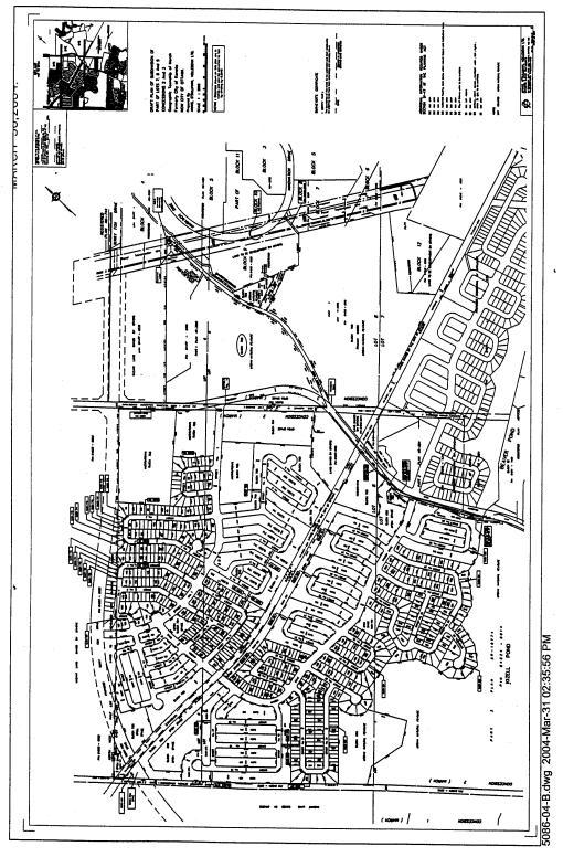
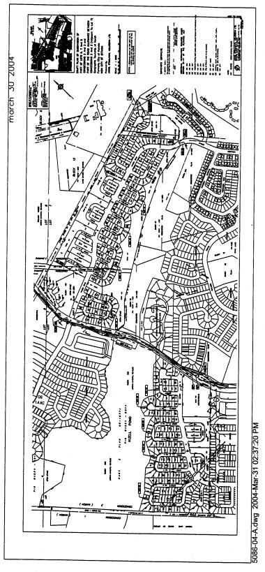
Document 5 – Proposed
Draft Plan of Subdivision A and B (2004) (Plan ‘H’)
Document 6 – Consultation
Details; Questions and Answers
Document 7 – Conditions
of Draft Plan of Subdivision Approval
Document
8 – Table of 40% Land Area Calculations
– 1990 OP Designation vs. Current Proposal
DISPOSITION
Department of Corporate Services, Secretariat
Services to notify the owner (KNL Development Corporation, 2193 Arch Street,
Ottawa, ON K1G 2H5), applicant (D.W.
Kennedy Consulting Ltd., 604 Courtenay Avenue, Ottawa, ON K2A 3B5), All Signs, 8692 Russell Road,
Navan, ON K4B 1J1, and the Program
Manager, Assessment, Department of Corporate Services of City Council’s
decision.
Planning and Development Department to prepare
the implementing by-laws and forward to Legal Services Branch, and undertake
the statutory notification amendment to the Zoning by-law (167-93) of the
former City of Kanata.
Department of Corporate Services, Legal
Services Branch to forward the implementing by-law to City Council.
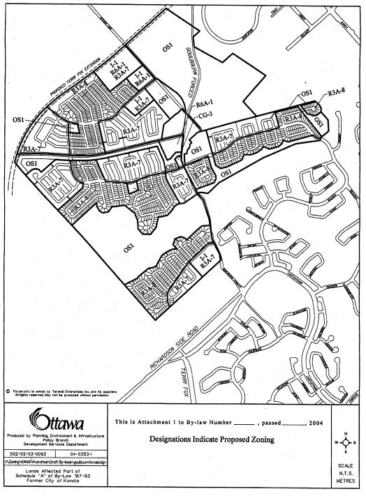
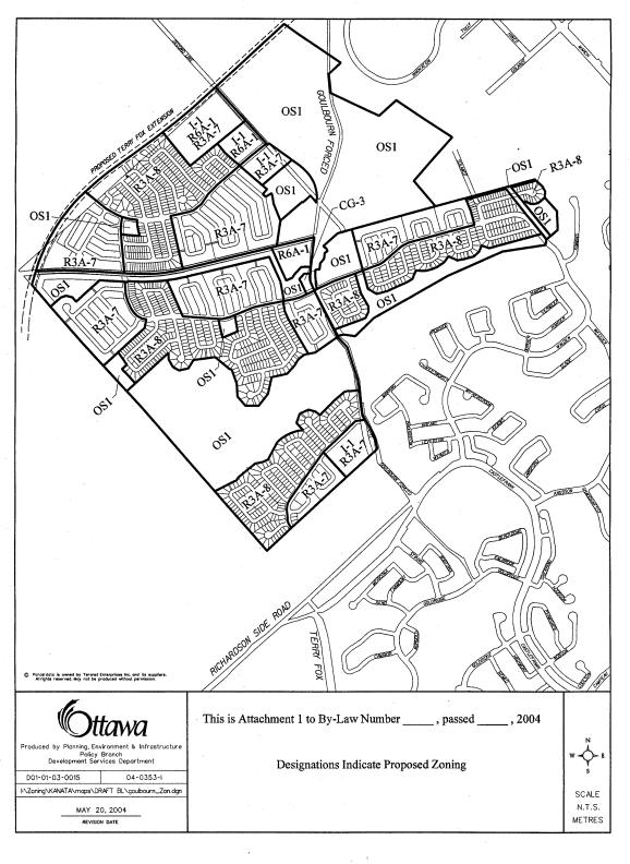
LOCATION MAP Document
1
Official
Plan Amendment
Modification
du Plan directeur
To the official plan of
the former City of Kanata
Land use
Utilisation du sol
________________________________________________________________________
INDEX
________________________________________________________________________
The Statement of Components
PART A - THE PREAMBLE
Purpose
Location
Basis
PART B- THE AMENDMENT
Introductory Statement
Details of the Amendment
PART C - APPENDIX
Appendices
THE
STATEMENT OF COMPONENTS
PART A - THE PREAMBLE, introduces the actual Amendment but does not constitute part of
Amendment No.______ to the former City of Kanata Official Plan.
PART B - THE AMENDMENT, consisting of the following text constitutes the actual Amendment
No. ______ to the former City of Kanata Official Plan.
PART C - THE APPENDIX, does not form part of the Amendment but is provided to clarify the
intent and to supply background information related to the Amendment.
PART
A - THE PREAMBLE
1. Purpose
The purpose of this Amendment is to
shift the boundaries of land use designations and change the land use
designations of lands shown on Schedule “A”, being a part of Schedule “B” to
the Official Plan of the former City of Kanata. The land use to be modified are “Environmental Protection Area”,
“Residential Low Density”, “Residential Medium Density”, “Residential High
Density”, “Neighbourhood Commercial”, “Community Commercial”, “Institutional”,
and “Opens Space”.
2. Location
The lands affected by this Amendment cover an area
of 269 hectares and represent the majority of the remaining undeveloped land in
the Marchwood-Lakeside Community (Kanata Lakes). The affected area straddles the Kizell Pond and runs north of the
Beaver Pond. The limits of this
development run from the unopened First Line Road allowance in the west to the
Kanata North Business Park in the east.
The northern limit abuts the South March (Morgan’s Grant) Community.
The lands
affected by the Amendment are highlighted on Schedule “A” to this Amendment,
which is a portion of Schedule “B”, Urban
Area - Land Use, to the Official Plan of the former City of Kanata. The changes in land use designations are
described in the Purpose section of the Amendment, and reflected on Schedule
“A” to this Amendment.
3. Basis
This amendment re-designates the subject lands by shifting
boundaries of the current land use designations. The existing designations were set on the basis of a 1987 Concept
Plan for the development of the Marchwood-Lakeside Community. The proposed re-designations will implement
a proposed Draft Plan of Subdivision that includes the remainder of
neighbourhood 4 in Marchwood and the three neighbourhoods of the Lakeside
Community in their entirety.
The proposed Amendment will adjust the
boundaries of residential designations, move school, park and commercial sites
and re-align certain collector streets.
Some policy amendments are also proposed, reducing the minimum lot size
for the commercial use, and de-centralizing the location of schools and parks.
The proposed Draft Plan of Subdivision
would result in a lower housing yield and population than what is currently
targeted within the Kanata Official Plan for the Marchwood and Lakeside
Communities. Amendment No. XX will
therefore encourage densities to be increased wherever possible by assigning a
dual “Low Density/Medium Density” designation where lotting for singles is
proposed by the Draft Plan. In
addition, school sites are assigned multiple designations to encourage medium
or high density residential development should the school boards not acquire
the lands.
Amendment No. XX also adjusts the boundary
of the “Environmental Protection Area” designation. Current Kanata Official Plan policies require this boundary to be
specifically defined through the subdivision approval process. The appropriate
studies and draft plan have been prepared and the boundaries are to be modified
through this OPA.
The location of the “Environmental
Protection Area” north of the Beaver Pond remains relatively unchanged, with
the exception of a small amount of open space west of Kimmins Court and the
addition of a 40 metre wide corridor connecting the Beaver Pond and Trillium
Woods. Also, Shirley’s Brook, its
required 30 metre buffer and a small active park providing a mini soccer pitch
and tot lot will be added at the southeast intersection of Goulbourn Forced
road and the rail right-of-way. The
“EPA” lands on the west side of Goulbourn Forced Road at Kizell pond have been
decreased along the northern edge where this boundary has been shifted to the
south. This is the area of greatest change between the current “EPA” boundary
and the proposed new boundary. This is
due to the transfer of former “EPA” land to new “EPA” requirements (Shirley’s
Brook) and previous excess land allocation under the 40% agreement. The designation of Trillium Woods as “EPA”
remains unchanged.
Amendment No. XX modifies Schedule ‘C’ –
“Roads” to incorporate the new alignment of collector streets as proposed by
the draft plan of subdivision. The
Walden Drive connection to Terry Fox Drive to the west, through the Special
Study Area lands, is deleted. The
Solandt Road connection remains unchanged on the schedule, but a new policy
will permit its deletion subject to appropriate studies being undertaken by the
applicant and approved by the City, and subject to the provision of alternate
access to development land within the Kanata North Business Park.
The new City of Ottawa Official Plan designates the lands as
“General Urban Area” and “Urban Natural Feature”. This plan is currently under appeal in its entirety. Had the Ottawa Official Plan not been
appealed, this Amendment would not be necessary. The proposed land use designations are in conformity with the
Ottawa Official Plan. Similarly, the
proposed land use designations are also in conformity with the currently
applicable Regional Official Plan, which designates the lands as “General Urban
Area” and “Natural Environment Area-A”.
PART B - THE AMENDMENT
1. Introduction
All
of this part of this document entitled Part B - The Amendment, consisting of
the following text and the attached map designated Schedule “A” to Amendment
No. XX (Urban Area- Land Use), constitutes Amendment No. XX to the Official
Plan of the former City of Kanata.
2. Details
The following
changes are hereby made to the Official Plan of the former City of Kanata:
1.
That Schedule “B” - Urban Area - Land Use is hereby amended by deleting the designations “RL”, “RM”,
“RH”, “I”, “OS”, “CC”, and “EPA” on said Schedule “B” insofar as it applies to
the lands identified on Schedule “A” to this Amendment, and substituting
therefore the designations “RL”, “RM”, “RH”, “I”, “OS”, “CN” and “EPA” as shown
on Schedule “A” to this Amendment.
2.
That Schedule “C” - Urban Area – Roads and Community
Phasing is hereby amended by deleting the road connection of Walden Drive
to future Terry Fox Drive to the west, on said Schedule “C” insofar as it
applies to the lands identified on Schedule “B” to this Amendment.
3.
That Subsection 5.3.1.4. is hereby
amended by deleting the words “elementary schools and recreational facilities”
4.
That Subsection 5.3.5.2 is hereby
amended by deleting the clause “location of the Black Cherry trees on the north
side of Kanata Pond” and replacing it with “wetland boundaries”.
5.
That Subsection 5.3.10.1 is hereby
amended by adding the following new paragraph:
“Notwithstanding the recommendation of this Transportation Study, a
revised study will be undertaken by the developer to determine the feasibility
of deleting the road connection between Lakeside Neighbourhood 1 and the
Neighbourhood Collector in Kanata North Business Park. The feasibility of deleting the Solandt Road
connection will also consider the provision of alternate access to Block 12 on
Plan 4M-1075 in the Kanata North Business Park. Should deletion of this road connection be approved by City
staff, no further amendment to this Plan, including Schedule ‘C’ – “Urban Area
Roads & Community Phasing” shall be required.
6.
That Subsection 6.4.2.2. is hereby
amended by deleting the clause “the Black Cherry trees on the north side of
Kanata Pond”.
7.
That Subsection 6.5.3.6 is hereby
amended by deleting “0.8” and replacing it with “0.5”.
8.
That Subsection 6.8.3.2 is hereby
amended by deleting the references to Marchwood and Lakeside and replacing them
with the following:
“Marchwood 1 Public Elementary
1
Separate Elementary
1
Separate High School
Lakeside 1 Public Elementary
1
Separate Elementary
1
Public High School”
9.
That Subsection 9.1.5 is hereby
deleted in its entirety.
10. That Table 2 – “Residential Densities; 3. High Density” is hereby
amended by adding the following clause after “99 units per net net hectare”:
“except that the RH site in Lakeside may be increased to 150 units per net net
hectare”.
3. Implementation
The implementation
of this Amendment to the Official Plan shall be in accordance with the
respective policies of the Official Plan of the City of Kanata, and with the
provisions of By-law 167-93, as amended, being the Zoning By-law for the
Marchwood-Lakeside Community.
AS RECOMMENDED BY STAFF
AS AMENDED BY PEC
At the request
of the Kanata Lakes Community Association (KLCA), meetings were held with
staff, and site visits and walking tours of the existing and proposed trails
were undertaken shortly after the original application was circulated in the
summer of 2003. A Commmunity
Information Session was held in the community on September 18, 2003. Signatures of those in attendance numbered
approximately 400, and the local newspaper estimated attendance at
approximately 600 people. The primary matter of concern to the community was
the desire to prohibit development on the forested land north of the Beaver
Pond, south of the rail line and Trillium Woods. Those in attendance expressed a desire to maintain their current
use of the receational trails in this area.
This is the area that has been designated for urban residential
development since 1983.
Focus Group
Staff
coordinated a facilitated focus group in an effort to obtain community input in
a more efficient and productive manner.
Invitees included representatives from the three most affected Community
Associations (KLCA, Beaverbrook Community Association, and Morgan’s
Grant/Briarbrook Community Association) as well as organized groups that had
previously provided input and written comments about the applications. These groups included the Kanata Survey
Group, the Trails Advisory Committee, The Ottawa Forest and Greenspace Advisory
Committee and the Environmental Advisory Committee.
The focus group meeting, held December
17, 2003, considered the proposed draft plan of subdivision within the context
of the 40% Agreement. Participants
provided written comments to City staff following the meeting. The comments highlighted the difference of
opinion that continued to exist between the groups in terms of which areas
should be allocated as open space under the 40% agreement, the primary
difference being the preservation of lands north of the Beaver Pond or lands
north of Kizell Pond in the “west block”, known for its mature beech forest.
At the earliest
Focus Group meeting, the Beaverbrook Community Association and the Kanata
Survey Group considered preservation of the lands north of Beaver Pond as a
priority. Another group, represented
mainly by Kanata Lakes Community Association (KLCA) and environmental groups
saw preservation of the “west block” as a high priority.
Following from
this, staff and the applicant began an intensive review and negotiation process
to find additional 40% land that could be allocated to one or both of the areas
known to be of greatest concern to the community. A “savings” in 40% land was achieved by reducing three proposed
north-south linkages between Beaver Pond and Trillium Woods into one 40 metre
wide corridor. A large rock knoll
located at the intersection of the rail line and future Terry Fox will not be
considered, in its entirety, under the 40% agreement, despite the developer’s
earlier request for the City to accept it as Open Space. Buffers along the rail line were removed
wherever possible, and rear yard setbacks are increased as an alternative. Also, the rock knoll located west of the
Kizell Drain open space buffer behind Kimmins Court was deleted and proposed
for development. The discussions
resulted in the “freeing up” of approximately 5.67 hectares of “EPA” land.
Subsequently,
Plans A, B and C were developed as alternatives and presented at a second focus
group meeting, held on February 3, 2004.
All of the plans were generally based on the original 2003 subdivision
submission. Plan ‘A’ added the “found”
5.67 hectares to the “west block”, north of Kizell Pond. This was the plan that was most supported by
Planning Staff as it preserves more of the most environmentally valuable land,
in keeping with the City’s Natural Environment policies, yet the plan still
provides buffered recreational trails along the northern perimeter of Beaver
Pond, as was planned by the original 1990 concept plan.
Plan ‘B’
distributes the “found” 5.67 hectares along the northern perimeter of the
Beaver Pond and replaces the “Environmental Protection Area” (EPA) designation
to the rock knoll at Kimmins Court. The
“west block” becomes development land under this plan. This plan was most preferred by community
groups.
Plan ‘C’ divides
the 5.67 hectares between the two areas.
It preserves approximately one third of the “west block” that is
currently designated for protection by the three Official Plans. The plan preserves the rock knoll to the
west of Kimmins Court and widens the treed buffer along the north sideof the
Beaver Pond.
Conclusions of
this second focus group meeting found that opinions continued to differ with
respect to the preferred allocation of the 40% open space lands. That is, environmental groups continued to
support preservation of the “west block” over widening the buffer along the
north perimeter of the Beaver Pond. The
community groups generally supported the latter, but have never specifically
supported any of the plans presented.
The position of the community has been that certain lands accepted by
staff as falling within the definition of the 40% agreement should not be
accepted as such. The community
suggests that between 10 to 20 hectares of land can be freed up and
redesignated from their current “environmental protection” designation to one
that permits development in order to preserve a larger portion of lands north
of the Beaver Pond.
Subdivision Public Meeting
The public
meeting with respect to the subdivision application, as requried by the
Planning Act, was held on Februrary 16, 2004.
There were approximately 150 people in attendance at the meeting who,
again, supported preservation of the lands north of the Beaver Pond.
The Kanata Lakes and Beaverbrook
Community Associations, as well as the Kanata Survey Group presented their
opinions in the context of a plan they called Plan ‘D’ or Plan ‘C-plus’. Their plan preserves a greater portion of
the land north of the Beaver Pond, as well as some of the “west block”. To achieve Plan ‘D’, and “find” additional
40% land, the following modifications were made by the community:
- Fill in a significant portion of
Kizell Pond and use the compensation lands to the west for stormwater
management purposes;
- delete Shirley’s Brook;
- delete the neighbourhood park (and
tot lot) in Neighbourhood 1 of Lakeside;
- delete buffered recreational
pathways along the south side of Kizell Pond;
- permit development on land that was
clearcut and resulted in the “Compensation Land” deal in 2002;
- access was (inadvertently) removed
to existing pedestrian crossing over the rail line; and
- reduce playing fields in the
community park from 4 to 3 potentially by using a shared land arrangement
with the adjacent school.
These and other
suggestions had been made previously by the public and by community
representatives throughout the Focus Group sessions. Staff have provided the rationale for the infeasibility of the
proposed modifications at public meetings, through the Focus Group Sesssions
and through direct correspondence. The
list of community questions and suggestions and staff responses is outlined in
detail within the “Question and Answer” section of Document 6.
Plan ‘H’
Following the
Public Meeting, staff and the applicant gave further review to the subdivision
plan with a view to finding additional land to be attributed to the Beaver Pond
area. Staff have agreed to permit
development to encroach into the buffer surrounding Kizell Pond, including
approximately two acres of the higher, developable clearcut land. In addition, the “west block” has been
reduced in area. These “EPA” lands have
been tranferred to the Beaver Pond area, including to the rock knoll to the
west of Kimmins Court.
A further
meeting was organized by the Councillor’s office on April 1, 2004 between the
applicant, City staff, the community representatives and the Councillor to try
to reach a consensus on a plan. It is
Plan ‘H’ shown as Document 5 (A & B) that comes closest to achieving this
level of agreement between all parties.
The Table shown
as Document 8 highlights the changes in land area of the “EPA” designation
between the current OP designations and the proposed draft plan. This table shows that the Beaver Pond has
gained some land area, while Kizell Pond/west block has been reduced in size. New areas falling under the 40% agreement
(eg. Shirley’s Brook) are also listed under the 2004 concept plan.
Other Public Input
A written survey has been undertaken by an
ad-hoc community group. Representatives
of this group acted as full participants in the Focus Group sessions. The survey was extensive and was delivered
to households throughout Kanata, with 1300 returned. The group’s analysis of their survey found that the community’s
priority for natural area preservation is highest for Beaver Pond north,
followed by Trillium Woods, West Block and finally, Kizell Pond.
Finally, dozens of e-mails, letters and
petitions have also been received, with the primary goal being preservation of
lands north of the Beaver Pond. A
separate petition was also received from the residents of Kimmins Court who
objected to the loss of the rock knoll to the west, the majority of which has
since been reinstated. The questions
asked and points raised within the letters and e-mails are consolidated in the
“Questions and Answers” section that follows:
Questions and Answers:
1.
Q. Why can’t we just say “no” to
the developer and deny the applications?
A. The land was approved for urban development
as a result of an Ontario Municipal Board decision in 1983 and was supported by
both the City of Kanata and Region of Ottawa-Carleton through the 40% Agreement
which was signed in 1981. This legal
agreement, registered against the land, states:
“Campeau
(landowner at the time) and Kanata mutually covenant and agree to support the
application by the Region for approval of Official Plan Amendment No. 24 to the
Official Plan of the Ottawa-Carleton Planning Area…”
There is a long
history of approvals of Regional Official Plan Amendment No. 24 which brought
the land into an urban development designation, followed by City of Kanata
Official Plan Amendment No. 11 that implemented its current Official Plan
landuse designations, permitting residential development and setting out the
general location of “Environmental Protection Area”. The landowner has proceeded in good faith, believing in his
rights to develop the land. It is
therefore difficult to take away this right.
Such a decision by the City may be appealed to the OMB by the landowner.
2. Q.
The public wants to preserve as much of the land north of the Beaver
Pond as possible. Why isn’t City staff
insisting that the developer not build on these lands?
A. It is the provisions of the 40% agreement
that gives the City the right to 107.5 hectares of land to be dedicated as
“Open Space” within the current subdivision proposal. These provisions also set out what is defined as “Open Space”
under the agreement. That is, (1) the
golf course, (2) lands for stormwater management, (3) lands for natural
environment preservation and (4) lands to be used for park purposes all fall
within the definition of the 40% agreement.
The boundaries
of the natural environment areas have generally been defined by a subdivision
concept plan since 1988, which have been implemented in policy since 1990. This basically gives the landowner the legal
right to develop the lands within the landuse designations that are currently
in place in the Kanata, Regional, and New City of Ottawa Official Plan policy
documents.
The process of
finalizing the actual natural environment area boundaries has become, for City
staff, an exercise of negotiation with the landowner, balancing community
needs, and of applying proper planning principles (balancing the social
needs/demands of the community with development costs for the proponent,
larger City interests and the preservation of the environment).
Where Staff attempt to push the balance
of interests in favour of the community, the landowner can find the costs of
development to be too great. As a
simple example, installation of services running from Kimmins Court and Walden
Drive westerly to the Goulbourn Forced Road is necessary to service the lands
on the west side of Goulbourn Forced Road.
To install this amount of infrastructure without (sufficient) housing
development to offset the costs is unacceptable to the developer. They will appeal to the Ontario Municipal
Board.
The threat of losing local control of
the final plan layout to the OMB greatly inhibits the options available to City
staff for achieving a plan that meets all of the residents’ requests. The OMB will likely recognize the right the
landowner currently has to develop at least as much of the land north of the
Beaver Pond as is proposed by the current subdivision plan.
Filling in of Kizell Pond
3. Q. A
number of the community associations have suggested that existing Kizell Pond
“EPA” should be filled in for urban development. This area should be traded to allow the lands north of the Beaver
Pond to be preserved as environmental protection land instead.
A. There are planning policies, and environmental and social
benefits which support its designation for environmental preservation. There are also stormwater servicing
limitations and development constraints that preclude the implementation of
this idea.
Planning
Policy
Kizell Pond is
designated in all Official Plans as a natural environment area worthy of
protection. In the former Kanata
Official Plan, Kizell Pond is defined as part of the larger ecosystem of the
Kanata Pond/Kizell Creek Drainage Area.
It is designated Environmental Protection Area. Policy 5.3.5.3 of the former Kanata Official
Plan states:
“The
Kanata Pond shall provide the focal point for the Lakeside Community. It shall be used as a recreation area and
storm water management pond. It shall
provide one part of the buffer between the two communities and shall be an
important focal point for the total development area. The pond shall have both landscaped and natural edges linked by
the sidewalk/pathway system. In
accordance with Section 6.2 hereof, a Park Development Plan shall be prepared
for the Kanata Pond area”.
The preservation
of Kizell Pond is consistent with all natural environment policies in the three
effective Official Plans. As well as
the planning policy cited above.
Natural
Environment
Overall,
wetlands are an important environmental feature on the landscape. They are among the most productive and
biologically diverse habitats in Ontario.
Wetlands perform a number important functions including: the recharge and discharge of groundwater,
corridors for the movement of species between habitats, recreational
opportunities, provision of habitat for a wide variety of plant and wildlife
species and water quality improvement.
Over 70% of wetlands in southern Ontario have been lost to urbanization.
Kizell and
Beaver Ponds are important wetland features within a local planning
context. The Provincial Policy
Statement states that municipalities can identify other natural heritage
features and areas considered significant within their local context. Wetland habitat, especially open water
marshes, are under-represented in the Ottawa urban landscape based on the
initial findings of the City’s Urban Natural Features Study. The preservation of these wetlands
contributes to the overall biodiversity in the City.
Kizell Pond
represents a diverse wetland habitat of greater value than Beaver Pond. It supports cattail marsh and red maple and
deciduous swamp. The regionally
significant Blanding Turtle was observed in Kizell Pond during the 2002 field survey. Although the function of the swamp habitat
has been changed as a result of the tree-cutting incident, it still represents
wetland habitat that will rehabilitate and provide a greater diversity of
habitat as the woody vegetation grows.
Kizell Pond is also ecologically linked with the wetlands and upland
habitat directly to the west of First Line Road (compensation lands) and Beaver
Pond. Removing Kizell Pond would reduce
the overall environmental value of the NEA lands, including the lands to the north
and compensation lands to the west.
Wetland mapping
and evaluations undertaken by the Ministry of Natural Resources indicate the
local significance of the Kizell Drain Wetland Complex. The overall wetland score for this complex
is 582. The MNR defines Provincially
Significant Wetlands within northern and southern Ontario as any wetland that
achieves a score of 600 or more points.
While the Kizell Pond falls just short of meeting the requirements for
protection as a Provincially Significant Wetland under the Provincial Policy
Statements, it is short by only 18 points.
The MNR encourages the conservation of other Wetlands (Classes 4 through
7) throughout Ontario. City Planning
staff encourage and support the preservation of Kizell Pond as a locally
significant wetland that forms part of a larger complex, running from Beaver
Pond in the east, through the compensation lands to the west.
Mississippi Valley Conservation has taken
the following position with respect to Kizell Pond:
“Approximately
200 metres upstream of Goulbourn Forced Road is within the fill regulated area
of Kizell Drain under Ontario Regulation 159/90 (Fill, Construction and
alteration to Waterways). Therefore, in addition to any approval from the City
of Ottawa or any other agencies, a permit would be required from MVC before
this filling could occur. Staff of MVC
would not be in favour of this proposal.
Our policies generally do not support the filling of natural riverine
wetland areas. Among other functions,
this wetland area temporarily stores water that then contributes to the base
flow of Kizell Drain in dryer periods.
Substantial sections of Shirley’s Brook dry up in the summer
months. In comparison to Shirley’s
Brook, Kizell Drain has a much steadier base flow due to the mitigative effects
of the Beaver Pond and the upstream wetlands.
Therefore, filling in these wetlands would have impacts for all of the
Kizell Drain downstream of Goulbourn Forced Road. This area would also represent local fish habitat.”
MVC further states:
“The area around
Kizell Pond has been designated as a natural area (NEA in the Region’s Official
Plan and Urban Natural Feature in the new City of Ottawa Plan) in various
planning documents for almost 10 years.
MVC believes this is an appropriate designation for this area.”
For these
reasons, it is inappropriate for the City to endorse filling in this natural
feature. It is appropriate to preserve
the environmental integrity and fish habitat of the pond as much as possible.
Social
Benefits
Kizell Pond will be an important social
amenity area for the larger Kanata community as well as the future residents of
the Marchwood-Lakeside Community. It
will be a valuable asset for the community providing the same social function
that Beaver Pond presently contributes to the existing residents. The pathway system around its perimeter will
allow the users to have a “nature experience” right in their backyard. The wetlands can provide an outdoor
educational opportunity for the residents to learn about nature.
Servicing Limitations
The filling of Kizell Pond does not
appear feasible from a stormwater perspective.
Kizell Pond area is a designated storm water storage area for major
storm events. This was identified in
the Master Drainage Plan prepared for Kanata Lakes and is a basic assumption
that has been incorporated into all the storm sewer construction completed to
date. This use directly conflicts with
any proposal to develop the Kizell Pond and would require an alternative
storage area for this storm water.
There is no alternative storage area for stormwater for the entire
drainage area as well as the “new” development area. This is a problem that will not easily be resolved given the
significant increase in elevation of the surrounding area.
The western
limit of the KNL ownership is also very close to the split in watersheds
between the Kizell Drain and Carp River.
The low lands to the west of Kizell Pond are not available as an
alternative stormwater outlet as it would mean diverting drainage from one
watershed to another. Diversion of
flows from one watershed to another is generally discouraged because of its
negative environmental impacts on both watersheds. This is reinforced in the Council approved Shirley’s
Brook/Watts Creek Subwatershed Study which recommends that no diversion of
drainage can be undertaken as it would have negative impacts on base flow and
fisheries within Shirley’s Brook.
Economic
The Kizell Pond
area has been identified as an area to be left undeveloped since the original
concept plan was prepared for Kanata Lakes in the 1980s and existing
infrastructure has not been designed to support the development of this
area. In order to develop Kizell Pond,
environmental impacts aside, it would be necessary to remove the organic material
from the pond area and fill the entire area with engineered fill above the
1:100 year flood levels of Kizell Pond.
It would be cost prohibitive to develop this area in this manner.
An assessment
was undertaken by a professional engineer to evaluate the cost of developing
the south side of Kizell Pond. The
lands under consideration covered an area of 7 hectares, with 950 metres of
frontage along the south side of Kizell Pond.
Cross sections of grade differences were provided. The depth of peat is estimated to be between
2 and 6 metres.
The report
concludes that in order to build up to the extended limit of Kizell Pond, a
five-metre high retaining wall would be required as well as approximately 100
cubic metres of engineered fill per lineal metre Costs would be incurred to remove and
dispose of the peat and to dewater the excavation. Construction of the retaining wall and its required footings will
add to the costs associated with developing Kizell Pond. In addition, the sanitary sewer would need
to be lowered and the pedestrian pathway that is to run around the perimeter of
Kizell Pond would be relocated, requiring the removal of peat and replacement
with granular material. The costs for
these works are estimated as follows:
Engineered fill $4,750,000
Retaining wall $2,375,000
Retaining wall footings $ 950,000
Sanitary sewer overdepth $ 190,000
Pathway base $ 475,000
Total $8,740,000
The Engineering report concludes that
based on additional development costs well in excess of $8 million, it is not
feasible to develop this 7 hectare parcel of land. The aesthetics of a 5 metre high retaining wall is of concern to
both the developer and City staff.
4. Q.
How large an area is required for Kizell Pond to accommodate its stormwater
management function?
A. From an environmental perspective, the
wetland feature and functions would benefit from sustaining current
volumes. Kizell Pond will be used as a
stormwater management system, meaning the current hydrologic regime of the
wetland will have both on-site and off-site benefits. Maintaining water volume within the wetland will improve the
wetland’s ability to remove impurities from the water. This wetland is the headwaters to Kizell
Drain/Watts Creek. Maintaining the wetland
and its hydrologic function will help to ensure that there is no negative
impact on baseflow and subsequently aquatic habitat downstream. Wetlands have the ability to store water and
slowly release it during dry periods when baseflow is very low. This helps to sustain fisheries within the
watercourse during summer dry periods.
The actual
surface area required for the pond depends on the total storage volume
required. Preliminary modeling of the storm system has suggests that the 100
year storm elevation of the pond will follow the 94.3m contour interval. This may change as the design evolves. Draft Plan conditions of subdivision
approval will require that a final stormwater management plan be approved prior
to registration of this phase of the subdivision.
5. Q.
If Kizell Pond is not appropriate to be filled in for development, then
why not fill part of it in to accommodate the City’s active park requirements? Can it be used for the soccer pitches?
A. This being a community scale park, it is most
appropriately located with frontage along the primary collector road, being
Goulbourn Forced Road. The grades at
this section of Kizell Pond would make filling in and leveling the land for the
purpose of soccer pitches challenging and costly to the municipality. This is not the preferred location from a
community planning, or from an engineering perspective. It is staff’s opinion that the costs
outweigh the benefits of preserving additional urban natural environment land
in this instance.
In addition, it
is desirable from an environmental perspective to maintain the existing size of
Kizell Pond in order to maintain its ecological integrity. It is acknowledged that its use as a
stormwater management pond will have an ecological impact. Maintaining a larger size of wetland pond
will minimize this impact, allowing pollutants to more easily and fully
dissipate.
Economically,
such a proposal would also be cost prohibitive, as the peat would have to be
removed and be replaced with engineered fill. Peat is extremely frost
susceptible with no guarantee as to how it would settle each spring. If the
peat were not removed, the likely result would be an undulating playing surface
that would be unacceptable from both a safety and a usability perspective.
6. Q. Do not accept the
damaged, clear cut area of Kizell Pond as Natural Environment Area (NEA) or as
dedication under the 40% Agreement.
A. The unauthorized tree cutting incident in
April of 2002 damaged approximately 4 hecatres of the Kizell Pond Natural Environment
Area. Within the NEA boundary,
extensive tree removal occurred in the cedar upland forest south of Kizell
Pond, immediately west of Goulbourn Forced Road, and within the ash and maple
swamp to the west of Kizell Pond, east of the First Line Road allowance. Tree removal also occurred at the edge of
the wetland habitat west of Goulbourn Forced Road, on the south side of the
pond. The damaged area extended to the
north side of Kizell Pond on a portion of upland deciduous forest, contiguous
with the impacted swamp area.
Immediately
following the tree cutting, the City negotiated a settlement with the landowner
that resulted in agreement that the damaged area within the original NEA
boundary would remain as natural environment area. The City maintains the position that the destruction of a
designated natural feature does not relieve an individual from the associated
protection policies. The developer is
required to rehabilitate the damaged habitat prior to the City accepting the
dedication of the lands. This
requirement is included within the draft plan of subdivision conditions. In addition, the monies from the tree
cutting ($10,000) will be used to prepare and implement a management plan for
the NEAs. Finally, the landowner will
provide compensation land immediately adjacent to Kizell Pond on the west side
of the First Line Road allowance at a ratio of three acres for each one acre
that was clear cut.
The majority of
the damaged area within Kizell Pond NEA was within the wetland itself. The damaged wetland areas cannot be taken
out of the larger natural feature. The
damaged area along the southern edge of Kizell Pond accomodates the
recreational pathway and helps to buffer the effects of adjacent development on
the wetland. From an environmental
perspective, this area should not be excluded from the Kizell Pond NEA as it
performs an environmental, social, recreational and stormwater function.
Nonetheless,
this 10 metre buffer surrounding Kizell Pond is an area that has been
compromised within the final proposed draft plan in order to achieve the
community’s desire for a wider buffer along the north side of Beaver Pond, and
to try to recoup the NEA land that was lost within the “west block”.
7. Q. Why is fish habitat and Shirley’s Brook considered under the 40%
Open Space Agreement?
A. The fish habitat resources west of Second
Line Road allowance were not incorporated in the natural areas and open space
network for the Marchwood-Lakeside Community in the former Kanata Official
Plan. The administration and
implementation of the Federal Fisheries Act as well as environmental attitude
has changed since the 1980s, which no longer allows creek systems to be piped.
However, to the east of the Second Line Road allowance, Shirley’s Brook and Kizell
Drain were included in the Environmental Protection Area designations
associated with Trillium Woods and Beaver Pond. Because watercourses and associated aquatic resources encompass
the 40% agreement principles as important natural features and habitat, the
remaining section of Shirley’s Brook was considered to be part of the 40% Open
Space Agreement (“lands for natural environment preservation”) for the subject
lands under consideration in this report.
8. Q. Does Shirley’s Brook
west of Goulbourn Forced Road constitute fish habitat? If so, can the creek corridor be decreased
to 20 metres from the proposed 30-metre corridor?
A. Shirley’s Brook was identified as fish
habitat in the Council approved Shirley’s Brook/Watts Creek Subwatershed
Plan. The report classifies
Shirley’s Brook within the development as Type 1 habitat. Mississippi Valley Conservation and
Department of Fisheries & Oceans conducted a further review of the
fisheries resources within Shirley’s Brook.
Field investigations conducted by both agencies verify that Shirley’s
Brook constitutes fish habitat within its entire length of stream, including
east of Goulbourn Forced Road. Aquatic
inventory work associated with the future Terry Fox Drive Alignment north of
Richardson Side Road concluded that Shirley’s Brook west of Goulbourn Forced
Road would constitute fish habitat as well.
Shirley’s Brook
is a warm water tolerant fish habitat.
The Council approved Shirley’s Brook/Watts Creek Subwatershed Plan recommends
a 15 metre setback from top-of-bank.
Therefore a 30 metre corridor is required, at a minimum, to accommodate
the stream and appropriate setbacks.
Moreover, rehabilitation of the relocated creek will require the creek
to meander in a natural manner.
Consequently, the 30 metre wide open space area to be dedicated under
the 40% agreement may ultimately need to be wider at some points to accommodate
the meander. Where this is necessary,
the open space dedication will not come out of the 40% allotment. This will be a condition of draft plan
approval, and will be adjusted on the final plans prior to registration.
Community
representatives have suggested moving the “buffer” north so that it is
incorporated within the City’s rail right of way, thus reducing the 40%
allocation required for Shirley’s Brook.
However, the meandering of the brook that will be necessary to improve
fish habitat over current conditions could cause the brook itself to encroach
into the right of way that is protected for possible future light rail.
In a letter
provided by DFO, dated February 27, 2004, the comments state: “We consider the
proposed relocation of Shirley’s Brook between the existing Goulbourn Forced
Road and the eventual new Terry Fox Road to be acceptable in principle.
Maximizing or accommodating the subdivision development potential of the land
is not considered as adequate justification for a Harmful Alteration,
Disruption or Destruction (HADD). In
this instance, we see the relocation as an opportunity to achieve a
considerable net gain of habitat. This
opinion is based on the understanding that the end result will provide equal or
increased stream length and improved quality of fish habitat.”
Conditions requiring DFO and MVC
approval prior to registration of the subdivision are included as conditions of
Draft Plan of Subdivision Approval.
9. Q.
Why are the applications proceeding prior to Department of Fisheries and
Oceans approvals for relocation of Shirley’s Brook west of Goulbourn Forced
Road?
A. The City received comments on June 26, 2003,
from the MVC who were circulated the applications for an Official Plan
amendment, Zoning By-law amendment and draft plan of subdivision earlier in
June, 2003. The response at that time
contained the standard requirement to include DFO approval as a condition of
Draft Plan of Subdivision approval.
That is, DFO approval is required to permit relocation of the brook
prior to registration of the subdivision.
A new, revised
comment was received from MVC in January, 2004. The comments indicate that MVC does not recommend approval of the
draft plan prior to DFO approval. A
meeting was subsequently held with DFO and MVC to resolve the matter. MVC now approve of the issuance of draft
plan approval to the plan of subdivision, subject to conditions that will
require the approval of DFO in advance of subdivision registration.
10.
Q. Why are the recommendations
of the Brunton study of 1992 not being implemented?
A. Daniel Brunton was retained in 1992 by the
former City of Kanata, in cooperation with the Kanata Lakes Community
Association and Genstar, the landowner at the time, to undertake an
environmental assessment of the natural features within the Kanata Lakes
area. One of the objectives of the
study was to clarify the boundaries and extent of the existing Natural
Environment Areas. Based on Brunton’s
findings, four major upland forested areas of significance were identified and
prioritized as follows: 1) Trillium Woods,
2) West Block, 3) Kanata Pond Ridge (north of Beaver Pond) and, 4) Snake Road
outcrop (north of railway corridor, west of Goulbourn Forced Road).
The Official
Plans of the former City of Kanata and the former Regional Municipality of
Ottawa-Carleton were never amended to fully implement Brunton’s 1992 study
recommendations. The natural area
designations and conceptual delineation that existed in the 1990 Kanata
Official Plan and the Regional Plan have now been approved within the new City
of Ottawa Official Plan.
Brunton’s
findings may be environmentally sound.
However, because the landuse policies and designations within the
various Official Plans never implemented the findings, the upland forest south
of Trillium Woods, north of Beaver Pond continues to be designated for urban
development today.
Trillium Woods
north of the railway corridor is designated in all Official Plans for
environmental preservation. Recently,
the City purchased, through a land exchange, the northern portion of Trillium
Woods, south of Terry Fox Drive, adding natural environment lands to the Trillium
Woods.
The majority of
the “west block” is also currently designated as natural environment area. However, this particular area will now be
reduced in area due to the open space requirements associated with the 40%
Agreement. City staff have been supporting
allocation of open space area to the west block to preserve as much as possible
its ecological integrity and function as part of the greater South March
Highlands area. The attention to the
“west block” is consistent with Brunton’s recommendations as this was the
second highest environmental area within Kanata Lakes.
11. Q. Where are the Black Cherry Trees that are
referenced in the 1992 Brunton Report, and are they being saved?
A. Both ESG’s 2002 report and Brunton’s 1992
study state that the Black Cherry species are situated on drier, rocky ground
north and south of the CNR Tracks east of Goulbourn Forced Road, particularly
north of the CNR tracks.
A draft plan
condition will be included that will require the siting and identification of
Black Cherry trees within the required Tree Preservation Plan. The trees will be preserved where
possible. The Tree Preservation Plan
must meet with staff approval.
12. The community has raised concerns about the
proximity of the school blocks to Trillium Woods.
A. The school boards do not share the concern
and indicate that school sites have often been set in proximity to forested
areas. Staff find the proximity of the
two uses to be beneficial insofar as additional parking and washroom facilities
can be made available for each use.
Moreover, the location of these uses fronting along Goulbourn Forced
Road is beneficial from a design perspective as it minimizes the occurrence of
residential reverse lotting where noise walls would likely be required. Accessibility is improved from a
transportation perspective by keeping traffic on the collector roads and off
local streets. Moreover, the proposed
sites will be well served by public transit and a network of public sidewalks
and pathway linkages.
13. Utilize a shared parking arrangement between
the school site(s) and the community-scale park.
A. The community would like to reduce the area
of active parkland within the subdivision and transfer the open space to
forested lands north of the Beaver Pond.
Staff have considered the option of relying on a “shared parking”
arrangement by combining a school site with the Community Park, which could
save approximately 0.8 hectares.
However, such an arrangement hinges on the school board taking its
option on the site. Where a school
board does not exercise its option, the City is unable to provide the
facilities originally intended for the park.
There have been two instances within the existing Marchwood Community
where parks could not be developed or completed in a timely manner due to a
shared land arrangement with school boards.
Staff are therefore recommending that the full area required for active
parkland be designated for such use.
14. Q.
Take the 6 acres from the yet-to-be developed Walden Park and apply it
to lands north of the Beaver Pond. The
school has decided not to build there anyway.
A. The school has not yet exercised its option,
but it has also not waived it. Recent
discussions with the school board indicate there is still strong consideration
of this site for an elementary school.
Walden Park is
actually City-owned. Lands north of the
Beaver Pond, including the rock knoll west of Kimmins Court, continue to be
owned by the developer. It is not City
practice to sell City-owned parkland for development purposes, nor is it
appropriate to set such a precedent.
The budget for
park development was to be spent this year to develop the park. The project has been deferred for another
year in anticipation of the school taking its option.
Planning staff
do not support the sacrifice of planned urban active parks for forested land
within an urban community where the need for active parkland has been
identified.
The Park Development Plan for this park is
complete.
15. Q. A petition was received
from Kimmins Court residents opposing the redesignation of a portion of the EPA
lands nearest their homes, west of the hydro corridor. The petition refers to the rock knoll area
as Parkland and expresses concern about wildlife habitat being affected. Residents state that development should not
occur on the lands between Kimmins Court and the Hydro Corridor to the west.
A. The land is not parkland. It is owned by the developer and was
designated as Environmental Protection Area (EPA) at the same time as the “west
block” lands were also designated “EPA”.
There is currently city-owned open space surrounding the homes on
Kimmins Court, where Kizell Creek runs through. The creek will continue to have a 15-metre buffer on either side
for protection of fish habitat. This
buffer is similar in width to the buffer on the east side of Kimmins between it
and the Beaverbrook community. The
homes on Kimmins Court will remain buffered from development north of the
Beaver Pond by virtue of this city-owned open space.
Recent and past
studies (Muncaster 2001, Brunton 1992) did not find the EPA at the east end of
the Beaver Pond, north of Kimmins Court to be environmentally valuable. This area was found to have a high level of
disturbance due to the presence of the hydro line corridor and formal and
informal trails. The forested portion
of this area is immature and very fragmented with extensive areas without a
closed canopy of woody vegetation. The
most significant feature is Kizell Creek situated within the City-owned open
space lands adjacent to Kimmins Court.
Also, the sanitary sewer will run from the existing stub at the
cul-de-sac end of Kimmins Court and connect to Walden Drive to the west. This area will therefore be disturbed, and
has low environmental value.
As a result of further community
consultation, staff now support preserving most of the rock knoll between the
Kizell Creek open space and the hydro corridor. While this land is lower in environmental significance than the
“west block”, residents of Kimmins Court will be the most highly impacted by
the new development. Moreover, the
“EPA” designation was in place prior to construction of the homes. It is therefore appropriate to maintain the
buffer of the rock knoll for residents of this area, acknowledging that the
northern-most portion of the area will be developed to connect the sanitary
sewer that presently ends at the north end of Kimmins Court.
16. Q.
Why is the hydro corridor immediately west of Kimmins Court included in
the 40% agreement?
A. The corridor can be used to provide
pedestrian access to the rail right of way, leading to the existing pedestrian
crossing into Trillium Woods (over private property). It will be developed with a pedestrian pathway and is therefore
considered to be open space under the 40% agreement. It will be a condition of Draft Plan Approval for the developer
to construct the pathway to City standards.
17. Q.
The community wishes to prohibit development as much as possible, or in
its entirety, north of the Beaver Pond.
It is understood that the sanitary sewer and watermain will need to be
run from where they currently end, at Kimmins Court and Walden Drive, at the
east end of Beaver Pond respectively.
Instead of constructing Walden Drive through the north Beaver Pond
lands, the community suggests the lines should be run along the rail corridor
as an alternative to running the lines through Walden Drive, which is otherwise
required to service development on the west side of Goulbourn Forced Road.
A. The original community concern was that the
installation of the trunk sanitary sewer would require that an extra deep
trench be blasted through the rock knoll to the west of the power lines. This
sewer will now be located in street 20 parallel to the railway corridor
avoiding the rock knoll entirely. Where street 20 intersects Walden Drive, the
sewer will continue westerly in Walden Drive to Goulbourn Road.
Watermains are
buried at a depth of 2.4m below the crown of the road or finished grade when
not under a road. A watermain will need to be installed in Walden Drive to
service the lots that front onto it. The only difference in the size of a
watermain trench for a 200mm diameter local watermain versus a 400mm diameter
trunk is 200mm of extra depth to accommodate the larger diameter. Relocating the trunk watermain to adjacent
the railway corridor would not only be extremely costly, but would necessitate
additional blasting and tree removal.
Moreover, this
suggestion runs counter to the fundamental principles of servicing, such as
long-term dependability and accessibility to the infrastructure for
installation, operation and maintenance purposes, as well as capturing the
total drainage area for sewers, and cost effectiveness of design.
Trunk services are typically developed
using a central spine approach. This
affords the City the use of a trunk sewer to convey large flows, allowing it to
capture drainage from developments on either side of the sewer as it moves
toward the outlet. This approach is
intended to negate the need for multi-trunk sewer systems to service the same
area, adding to the cost of installation, operation and long-term maintenance.
It is not
appropriate for such services to be installed within private property, using
easements in favour of the City. These
services are typically constructed in lands that will be under municipal
ownership such as road allowances.
The local
sanitary collector sewer located north of the Beaver Pond has been part of the
wastewater servicing strategy for Kanata Lakes since the initial servicing
concept was prepared in the early 1980’s.
This sewer is proposed to drain all of the Kanata Lakes urban area north
of the Beaver Pond and Kizell Pond. To
do this, the sewer runs parallel to the Beaver Pond draining easterly to an
outlet which was provided at the north end of Kimmins Court as part of the very
first phase of development of Kanata Lakes. Consistent with this original
servicing strategy, the trunk sanitary sewer, which drains all of Kanata Lakes,
was reduced at the north limit of Kimmins Court to a size sufficient to drain
the urban area south of the Beaver Pond only.
These existing conditions alone make it necessary to install a collector
sewer north of the Beaver Pond, outletting to the north end of Kimmins Court.
18. Q.
If sewers are to be installed within Walden Drive, north of the Beaver
Pond, how deep will they need to blast and what impact will this have on the
remaining treed buffer along the north perimeter of the Beaver Pond?
A. Based on a preliminary sewer profile
provided by the applicant’s engineering firm, the sanitary sewer from the point
where it connects to the existing trunk sewer in the hydro corridor east of
Kimmins Court, to approximately the mid-point of Phase 2 (area north of the Beaver
Pond), has an average depth of 2 to 4 metres, with a maximum of 6 metres depth
at the connection point. The remainder
of the sewer as far west as Goulbourn Forced Road averages 4 to 5 metres in
depth except for three locations where it skirts or goes through knobs where
the maximum depth is 9 metres.
Staff have
discussed the matter of potential impact on trees from blasting with the City
Forester. In his experience in similar
situations, there is little impact to the trees caused by blasting in proximity
to a forested area. Instead, his
concern is for damage to trees caused by construction vehicles. His recommendations are to ensure
construction fencing is erected and present at all times. Further, that City Forestry staff will be
on-site to provide a significant lever of monitoring of construction
activity. Draft Plan conditions will be
applied to require adherence to this.
Construction fencing will be required to define the limit and protect
the natural environment area; and re-fuelling of construction vehicles will
only be permitted in designated areas.
In addition, it is a condition of draft plan approval that the Owner
shall provide a system of measures to protect the trees and their root systems
during blasting, to the satisfaction of the City.
19. Q. Who pays the cost of
installing infrastructure through the lands north of Beaver Pond?
All costs associated with development of
a parcel of land are paid by the developer up front, and ultimately, the new
home buyers. Once the works are completed
to the City’s satisfaction, the City will take ownership of the
infrastructure. At that point, City
funds are used for maintenance and life cycle costing of the infrastructure.
20. Q. Have the municipally owned road allowances
of Goulbourn Forced Road, through the Trillium Woods, and old Second Line Road
allowance been inadvertently included in the 40% calculation?
A. Confirmation from the Ontario Land Surveyor
indicates that 0.45 hectares for the community park was inadvertently included
in the 40% calculations. There is
therefore an additional 0.45 hectares to be put back into NEA lands. This has been added to the buffer north of
the Beaver Pond.
The existing
Goulbourn Forced Road Alignment will be traded with the developer for the new road
alignment where it veers from the Second Line Road allowance.
The old Second Line Road allowance to
the south of the rail right-of-way has already been closed and sold to the
abutting landowner, now the developer (KNL).
21. Q.
The municipally owned land immediately south of Terry Fox Drive
extension should be traded with the developer for additional 40% land.
A. This land is owned by the municipality and
is therefore not subject to the 40% agreement.
The City may exchange it with the developer for lands required to
construct Terry Fox Drive and, in particular, the stormwater management ponds
required to treat road drainage.
However, an
additional 0.8 hectares has been identified as 40% land where the City will
encroach into the rock knoll at the intersection of the rail line and Terry Fox
Drive overpass. In terms of the final
proposed draft plan, this has been kept in reserve. It is staff’s intention to add this area to the west block, if
possible, prior to registration of that phase.
22. Q.
Some residents object to the alignment of future Terry Fox Drive through
lands owned by the City and designated as natural environment area (South March
Highlands).
A. The alignment of Terry Fox Drive was set by
the Terry Fox Drive Environmental Assessment Study. The study has fulfilled the requirements of
the Environmental Assessment Act. The
matter is separate from the adjacent subdivision development by a private
developer.
However, the
land value of the environmental area required for the roadway will be put back
into the Environmental Lands Acquisition fund.
This fund was originally used to purchase the Terry Fox Drive
right-of-way through the South March Highlands Area.
23. Q.
The rock knoll at the intersection of the rail line and Terry Fox Drive
overpass should not be included in the 40% agreement.
A. Originally, staff had supported preservation
of this knoll as a focal point in this location. It would also serve as a significant connection between the
Shirley’s Brook pathway and the unopened First Line Road allowance pathway,
leading to west block/Kizell Pond and to the South March Highlands. However, due to other considerations and
trade-offs, it was reduced to a “nice to have” feature, but not necessary. Consequently, in negotiations with the
developer, staff refused to accept it as part of the 40% agreement. The developer would not agree. A negotiated settlement was reached that
resulted in the two parties splitting the difference. The rock knoll will remain undeveloped, at a cost of
approximately 1 hectare from the 40% allotment.
File: D07-16-03-0025
CONDITIONS FOR FINAL APPROVAL
KNL DEVELOPMENTS LTD.
LAKESIDE
SUBDIVISION
DRAFT APPROVED DD/MM/YYYY
The City of
Ottawa's conditions applying to the approval of the final plan for registration
of KNL Developments Ltd. subdivision (D07-16-03-0025) are as follows:
|
|
|
Agency to Clear
|
|
|
|
General
|
|
|
|
1.
|
This
approval applies to Draft Plans 1 and 2, certified by, Edward M. Lancaster,
Ontario Land Surveyor, dated 02 March 2004, Plan 1 being Part of Lots 6, 7
and 8, Concessions 2 and 3 and Part of the Road Allowance between Concessions
2 and 3, and Plan 2, being Part of Lots 7, 8 and 9, Concessions 2 and 3 of
the KNL development.
|
|
|
|
2.
|
The Owner
agrees, by entering into subdivision agreements, to satisfy all requirements,
financial and otherwise, of the City of Ottawa, including but not limited to,
the phasing of the plan for registration, the provision of roads, installation
of services and utilities, and drainage.
|
OTTAWA
(PPD)
|
|
|
3.
|
Any
residential blocks on the final plan shall be configured to ensure that there
will generally be no more than 25 units per block.
|
OTTAWA
(PPD)
|
|
|
4.
|
Prior
to any further division of lots or blocks, the City of Ottawa may require an
additional agreement to address any new or amended conditions.
|
OTTAWA
(PPD)
|
|
|
5.
|
That the Owner shall employ Professional Engineers to the
satisfaction of the City, to design and supervise the construction of the Subdivision
Works in accordance with the City Specifications. No departure from the City Specifications is permitted without
the written consent of the City.
"As Built" drawings of the development works shall be
provided to the City's satisfaction.
|
OTTAWA
(PPD)
|
|
|
6.
|
The Owner agrees to promptly notify
the City Clerk in writing should any of the Works required by the Subdivision
Agreement be assigned to other parties.
Such notification shall not release the Owner of his obligation to
construct such Works.
|
OTTAWA
(PPD)
|
|
|
7.
|
The Owner agrees that its obligation to construct or
install the Works, as required by the Subdivision Agreement, shall not be
assigned to any party who purchases land on which a residence has been
constructed.
|
OTTAWA
(PPD)
|
|
|
8.
|
The Owner agrees to
co-ordinate the staging of the Subdivision to the satisfaction of the City in
consideration of the construction of the Works with the development of other
lands in the area, or provision of underground services within the
Subdivision.
|
OTTAWA
(PPD)
|
|
|
9.
|
The
Owner agrees that, where applicable, all Offers of Purchase and Sale shall
contain a clause notifying the purchasers of the type, location, construction
and size of any sidewalk abutting the lands, which are the subject of the
offer.
|
OTTAWA
(PPD)
|
|
|
10.
|
The
Owner agrees to implement the recommendations of all applicable reports. The
Owner acknowledges and agrees that all reports and/or studies required as a
result of the approval of the Plan of Subdivision shall be implemented to the
satisfaction of the City at the sole expense of the Owner. Further, that the
City may require certification by the Owners Professional consultants that
the works have been designed and constructed in accordance with the approved
reports, studies, standards specifications, and plans to the satisfaction of
the City.
|
OTTAWA
(PPD)
|
|
|
|
Zoning
|
|
|
|
11.
|
Prior
to registration of the plan of subdivision, the City of Ottawa shall be
satisfied that the proposed plan of subdivision conforms with a zoning by-law
approved under the requirements of the Planning Act, with all possibility of
appeal to the Ontario Municipal Board exhausted.
|
OTTAWA
(PPD)
|
|
|
12.
|
For each
registration, the Owner shall provide a surveyor’s certificate from an
Ontario Land Surveyor indicating the frontage and area of all lots/blocks on
the final plan.
|
OTTAWA
(PPD)
|
|
|
|
Highways/Roads
|
|
|
|
13.
|
Prior
to registration the Owner shall to the satisfaction of the City revise the
final plan to :
1.
Eliminate the broken back curve at the east end of
Walden Drive. This shall include investigating the use of a portion of the
hydro corridor for part of the road allowance.
2.
Where possible provide blocks of land for grade
separation embankments at the intersection of Goulbourn Road and the Arnprior
Nepean Railway ROW .
3.
Where feasible, based on natural features and
topography, improve roadway connections between internal local streets and
eliminate cul-de-sacs, bulbs and eyebrows, to the satisfaction of the City.
|
OTTAWA
(PPD)
|
|
|
14.
|
The
Owner shall convey to the City, in accordance with the principles of the 40
percent agreement, an unencumbered road widening along the Second Line Road
allowance between Concessions 2 and 3 in conjunction with the dedication of
the realigned Goulbourn Forced Road. The Owner's certificate on the M-Plan
shall indicate which Block(s) (are) being dedicated as a public highway of
the City of Ottawa, which plan shall be submitted in draft to the City
Surveyor.
|
OTTAWA
(PPD)
|
|
|
15.
|
Where
deemed applicable, at the City’s discretion, the Owner shall convey to the
City, at no cost, the land required to construct grade-separated crossings.
|
OTTAWA
(PPD)
|
|
|
16.
|
The
design of all road intersections, including geometric, intersection spacing,
grades, the conveyance of the necessary sight triangles and required 0.3 m
reserves necessary for lot access control, shall be to the satisfaction of
the City of Ottawa.
|
OTTAWA
(PPD)
|
|
|
17.
|
The Owner shall undertake to have the approved Subdivision
Transportation Impact Study updated by a Professional engineer with expertise
in undertaking such studies, for each phase of development The updates shall
comply with the City of Ottawa’s Transportation Impact Study Guidelines
(September 1995) in confirming corridor protection requirements, intersection
configurations and turning lane requirements as well as identifying TDM
measures and analyzing traffic impacts, transit impacts and implications for
pedestrian and bicycle movements. The
methodology and analysis principles shall be to the satisfaction of the City
of Ottawa.
The update for the first phase of development
shall also address the following matters:
1.
The requirement for the connection of Solandt Road
from Hines Road to Walden Drive.
2.
The timing and phasing of construction of all
collector roads including the construction of Terry Fox Drive to Goulbourn
Road.
3.
The requirement for temporary construction access
roads to accommodate construction traffic.
4.
Requirement of the Environmental Assessment Act.
The Owner shall, at its cost, implement the
recommendations of the revised approved study including any traffic signals,
when warranted, and related roadway modifications, subject to applicable
development charge contributions.
Further, the Owner will be responsible for the construction of Solandt
Road within its subdivision, subject to any applicable development charge
contributions, unless both of the following can be demonstrated:
1.
The approved Traffic Impact Study
indicates that the Solandt Road connection is not required and that the
balance of the road network can appropriately accommodate the traffic
movements to and from the subdivision;
2.
That the City secures alternate
public road access to Block 12, Plan 4M-1075, which was originally planned to
be accessed via the extension of Solandt Road.
|
OTTAWA
(PPD)
|
|
|
18.
|
The Owner agrees to transfer to the City at no cost, the land
required for Terry Fox Drive right-of-way upon request by the City.
|
OTTAWA
(PPD)
|
|
|
19.
|
All streets shall be named to the satisfaction of the City of
Ottawa.
|
OTTAWA
(PPD)
|
|
|
20.
|
The Owner shall, at its cost, apply for and obtain all necessary road
closings and applicable land transfers within the plan of subdivision. This shall be completed prior to the
registration of the plan of subdivision.
|
OTTAWA
(PPD)
|
|
|
21.
|
That the Owner acknowledges that the future Goulbourn Road is a
roadway eligible for funding from the Development Charge reserve at a rate of
90% of costs from Development Charges and 10%of the cost from a non-growth
fund in accordance with the commitments of the former Kanata Development
Charge Bylaw. The roadway is to be developed by the City in accordance with
any requirements stipulated in the Environmental Assessment Act.
As part of the detailed planning and design for Goulbourn Forced
Road, an environmental mitigation plan may be required, outlining the specific
mitigation and monitoring measures required to ensure minimal impacts to
Trillium Woods, Kizell Pond and Beaver Pond Urban Natural Features, as well
as Shirley’s Brook.
|
OTTAWA
(PPD)
|
|
|
22.
|
The Owner shall dedicate all proposed streets on Plan 1 and Plan 2,
in addition to the road widening block adjacent Block 703 on Plan 2 and Block
754 on Plan 2, as shown on the plans as Public Highways to the City.
|
OTTAWA
(PPD)
|
|
|
23.
|
The Owner shall at its sole cost prepare and register any reference
plans for the establishment of municipal rights of way crossings of the
Arnprior Nepean Railway corridor as required by the City. In addition, the Owner shall construct all
municipal roadway connections through the Arnprior Nepean Railway corridor
and all ancillary railway crossing requirements as established by and to the
satisfaction of the City and Transport Canada.
|
OTTAWA (PPD)
|
|
|
|
Public Transit
|
|
|
24.
|
The Owner shall design and construct, at no cost to the City of
Ottawa, Street No. 9, Walden Drive, and Street No. 1 connecting to Terry Fox
Drive, which have been identified for potential transit services, to TAC
standards, including right-of-way width, horizontal and vertical geometry,
and pavement structure and the construction of a sidewalk on both sides of
the street.
|
OTTAWA
(PPD)
OC Transpo
|
|
25.
|
The Owner shall:
1.
orient dwellings and vehicular
accesses in the vicinity of bus stops in a manner as to avoid traffic
conflicts and visual intrusion and to submit plans for approval by the City
of Ottawa indicating the orientation of all dwellings and private accesses in
the vicinity of all bus stop locations;
2.
inform all prospective purchasers
through a clause in all agreements of purchase and sale and indicate on all
plans used for marketing purposes that Goulbourn Forced Road, Street No. 9,
Walden Drive, and Street No. 1 connecting to Terry Fox Drive, have been
identified for potential transit services.
The locations of the bus stops, paved passenger standing areas, or
shelter pads and shelters, which may be located in front of or adjacent to
the purchasers' lots at any time shall also be indicated.
|
OTTAWA
(PPD)
OC Transpo
|
|
26.
|
The Owner
shall design and construct, at no cost to the City of Ottawa, paved transit
passenger standing areas, or shelter pads and shelters, to the specifications
of OC Transpo.
|
OTTAWA
(PPD)
OC Transpo
|
|
27.
|
The Owner
shall ensure that the staging of the subdivision, including dwellings,
roadways, walkways and paved passenger standing areas, or shelter pads and
shelters, will be constructed in a sequence that permits the operation of an
efficient, high-quality transit service at all stages of development.
|
OTTAWA
(PPD)
OC Transpo
|
|
28.
|
The following streets shall
be constructed to collector standards having a R.O.W. width of 26m with 11 m
of asphalt pavement and concrete sidewalks on both sides of the road:
Street No. 9 on Plan 1
Walden Drive
Street No 1 on Plan 2
The local streets on the
final plan shall have road allowance widths in accordance with the City’s
policies related to construction of sidewalks. This shall be to the satisfaction of the City.
.
|
OTTAWA
(PPD)
|
|
|
Sidewalks, Walkways,
and Fencing
|
|
|
29.
|
The
Owner shall design and construct at no cost to the City, public all season
pathways within walkway Blocks and in locations specified on the final plan
to the satisfaction of the City.
|
OTTAWA (PPD)
|
|
30.
|
The
Owner shall construct a pedestrian pathway, to City specifications, through
the hydro corridor (plan 1 blocks 500 & 502) located immediately west of
Kimmins Court, and running along the south side of the Rail line, connecting
to the existing pedestrian crossing of the Rail line.
|
OTTAWA
(PPD)
|
|
31.
|
If required,
the Owner shall construct fencing to City specifications along the shared
property line between the subdivision lands and the road allowance between
Concession 1 and 2, and adjacent to any park, walkway or open space blocks.
|
OTTAWA
(PPD)
|
|
32.
|
The Owner
shall install at its expense, fencing on the Railway right-of-way. Fencing shall be commercial grade chain
link, shall not contain gates, and shall be of a height and at a location to
be approved by the City prior to installation.
|
OTTAWA (PPD)
|
|
33.
|
The Owner
shall install at its expense, and to City specifications, fencing in the
following locations:
1.
fencing where required on park, open
space blocks and walkway blocks;
2.
perimeter fencing surrounding school
sites, where required
3.
along the rear and side property
lines of all lots abutting the Beaver Pond and Kizell Pond Urban Natural
Features and Shirley’s Brook
4.
perimeter fencing around Block 706
on Plan 2 where it abuts lands owned by others, the rail right-of-way and the
community park.
|
OTTAWA (PPD)
OCDSB; OCCSB
|
|
|
|
|
|
|
|
|
|
|
Tree Preservation and
Land/Streetscaping
|
|
|
34.
|
The Owner acknowledges and agrees to make every effort to preserve vegetation
and natural features located on the lands included in the Plan of
Subdivision. To this end, no trees
shall be cleared or significant natural features disturbed in any lots or
blocks within the Plan of Subdivision until an Existing Conditions and Natural
Features and Vegetation Preservation Plan, prepared by a Landscape Architect
in good standing with the Ontario Association of Landscape Architects,
showing existing contours and/or spot elevations, rock outcroppings, drainage
swales or ditches, and the location, species, size range and condition of all
stands of trees or outstanding specimens has been submitted to and approved
by the City of Ottawa prior to the City of Ottawa reviewing the Lot Grading
Plan.
|
OTTAWA
(PPD)
|
|
35.
|
The
Owner(s) shall undertake to protect all existing vegetation on site until
such time as a Detailed Tree
Planting and Conservation Plan is approved by the City and the vegetation
communities and specimen trees which are to be conserved are appropriately
marked with snow fencing on-site. The
City forester shall approve, on-site, the trees to be preserved and review
compliance of on-site works against the approved Tree Planting and
Conservation Plan. The Detailed Tree
Planting and Conservation Plan shall be prepared by a qualified landscape
architect and shall be integrated with the Grading and Drainage Plan, the
Storm water Site Management Plan and the Environmental Impact Statement.
|
OTTAWA
(PPD)
|
|
36.
|
The
Detailed Tree Planting and Conservation Plan shall specifically identify
Black Cherry species and preserve such trees wherever possible, to the
satisfaction of the Director of Planning and Infrastructure Approvals.
|
OTTAWA (PPD)
|
|
37.
|
The
Owner shall update the Kizell Pond Trail and Woodland Restoration Plan
(Corush, Sunderland, Wright, April 2003) to the satisfaction of the City to
ensure continuity of trails and appropriate connection to existing trails
based on the draft plan of subdivision.
The Owner shall be responsible for construction of the pathways and
implementing the approved plan at no cost to the City.
|
OTTAWA
(PPD)
|
|
38.
|
The
Owner shall, at its cost, revise the concept plan for the Beaver Pond Open
Space natural area. The Owner shall
implement the plan at its cost, subject to any development charge
contributions.
|
OTTAWA (PPD)
|
|
39.
|
The Owner shall provide
appropriate plans for the approval of the Director of Planning and
Infrastructure Approvals including the following:
2.
a
concept plan for each of the parks and open space/natural areas within the
area of the Draft Plan;
3.
an
indication of the location and alignment of the walking trails within the
Natural Environment Areas and Open Space areas and the abutting road
allowance between Concessions 1 and 2.
4.
a
cross-section of the trail construction detail;
5.
the
location, elevation and cross-section detail of any sound attenuation fence
required within the area of the Draft Plan;
6.
a
demarcation on the plan and cross-section indicating the treatment of the
boundary of open space and the rear of abutting lots; and
7.
an
indication of the street and park tree planting with a list of all proposed
trees and other plant materials and details of their size and method of
installation.
8.
The
Owner shall construct the trails in accordance with the approved Trail and Woodland Restoration Plan
for Kizell Pond, at no cost to the City, subject to any applicable
development charge contributions or obligations pursuant to existing
agreements.
|
OTTAWA
(PPD)
|
|
40.
|
The Owners shall implement the mitigation and monitoring measures
stated in the report “Environmental Impact Statement, Kanata Lakes North
(Muncaster, April 2003) to the satisfaction of the City which include but are
not limited to:
1.
The outside side of the natural
area’s buffers and open space areas will be clearly delineated with
construction fencing prior to any grading or other site alterations ;
2.
Woodchips will be placed on the
development side of the construction fencing to prevent compaction of soil;
3.
Tree removal will not occur between
May 15th and July 10th to protect breeding birds;
4.
No in-stream works within the
watercourse will occur between March 15th and June 30th;
5.
An approved system of measures to
protect the trees and their root systems during blasting.
|
OTTAWA
(PPD)
|
|
41.
|
Prior to registration, the Owner shall prepare, at no cost to the
City, the on-site remediation and restoration plan for each damaged area
within the Kizell Pond Urban Natural Feature as outlined in the Kanata Lakes NEA Boundary Definition,
Shirley Brook and Tree Cutting Mitigation Report (Muncaster, November 2002) to
the satisfaction of the City. The
restoration works will be implemented by the Owner and coordinated with the
installation of the pathway and storm water management works.
|
OTTAWA
(PPD)
|
|
42.
|
The Owner shall provide interpretative signs for each Urban
Natural Feature, in locations approved by the City, to indicate the sensitive
nature of the wetlands, woodlands and watercourses in the subdivision.
|
OTTAWA
(PPD)
|
|
43.
|
The
Owner shall dedicate at no cost to the City the following individual blocks
of land comprised of: 1) Kizell Pond
(Block 665), 2) Beaver Pond (Block 477) and
3) Trillium Woods (Blocks 760, 759, 758) Urban Natural Features in
healthy and restored condition to the City as “environmental lands”, in
accordance with the approved Plan. If
applicable, the Owner shall pay any land transfer tax associated with the
dedication of these lands.
|
OTTAWA
(PPD)
|
|
44.
|
The Owner(s) shall prepare to the satisfaction of the City, with
input from the community, a Conservation Handbook describing the natural
attributes of the subdivision and the importance of good stewardship
practices to ensure the long-term health and sustainability of Kizell Pond,
Beaver Pond and Trillium Woods Urban Natural Features and Shirley’s Brook.
The Handbook shall be distributed to all new home Owners within the
subdivision.
|
OTTAWA
(PPD)
|
|
45.
|
The Owner(s) shall design and construct at no cost to the City, a
pathway along one side of Shirley’s Brook for its entire length from
Goulbourn Forced Road, connecting to the unopened First Line Road allowance
to the satisfaction of the City, subject to applicable development charge
policies.
|
OTTAWA
(PPD)
|
|
46.
|
The Owner(s)
shall convey the lands containing Shirley’s Brook to the City (area to be
defined by survey) once the creek realignment and landscaping works have been
completed with all associated approvals, to the satisfaction of the City of
Ottawa.
|
OTTAWA
(PPD)
|
|
47.
|
That
the Owner acknowledges, and agrees, that prior to registration, the Owner
shall submit to the City and receive approval of, a Street Landscaping Plan,
by a Landscape Architect which plan shall specify:
1.
Footprints of building units, driveway locations, service drainage
swales, retaining walls, fences, street furniture, etc.
2.
trees at a minimum ratio of two (2) trees per building lot with one
(1) being located in the road allowance and one (1) on private property,
where possible and any surplus trees being located on corner lots, and
flankages.
3.
landscaping requirements for townhouse or multiple blocks within the
Plan of Subdivision will be addressed through Site Plan Control Approval
Process.
|
OTTAWA
(PPD)
|
|
|
Parks
|
|
|
48.
|
The
Owner shall “clean and green” all parks, including servicing, finished
grading, turf grass areas, paving, sand pits for play structures, parking
lots and walkways in accordance with the approved Park Concept Plan(s),
subject to applicable development charge contributions.
|
OTTAWA
(PPD)
|
|
|
Schools
|
|
|
49.
|
The Owner acknowledges and agrees to reserve
Block 756 in the subject draft plan of subdivision as an elementary school
site and Block 753 as a secondary school site for the Ottawa-Carleton
District School Board. The size,
configuration and servicing of the school site will be to the satisfaction of
the Ottawa-Carleton District School Board.
|
OTTAWA
(PPD), OCDSB, OCCSB
|
|
50.
|
The Owner agrees to enter into a legal
agreement with the Ottawa-Carleton District School Board for the reservation
of the delegated school sites known as Blocks 756 and 753, in the draft plan
of subdivision for a period of up to seven (7) years, from the date of
registration of the plan, which contains the subject school site.
|
OTTAWA
(PPD), OCDSB, OCCSB
|
|
51.
|
The Owner acknowledges and agrees to reserve
Blocks 515 and 705 in the subject draft plan of subdivision as elementary
school sites for the Ottawa-Carleton Catholic School Board. The size, configuration and servicing of
the school site will be to the satisfaction of the Ottawa-Carleton District
School Board.
|
OTTAWA
(PPD), OCDSB, OCCSB
|
|
52.
|
The Owner agrees to enter into a legal
agreement with the Ottawa-Carleton Catholic School Board for the reservation
of the delegated school sites known as Blocks 515 and 705, in the draft plan
of subdivision for a period of up to seven (7) years, from the date of
registration of the plan, which contains the subject school site.
|
OTTAWA
(PPD), OCDSB, OCCSB
|
|
|
Archaeology
|
|
|
53.
|
The Owner
shall undertake/agree to the following, to the satisfaction of the Ministry
of Citizenship, Culture and Recreation and the City of Ottawa:
1.
an archaeological assessment of the
entire property by a licensed consultant archaeologist, including 1:10,000
scale mapping, “Archaeological Site Record” and report(s);
2.
the implementation of the
recommendations of the approved assessment, including mitigation, through
preservation or removal and documentation of archaeological resources;
3.
no demolition, grading or other soil
disturbances shall take place until any archaeological resource conservation
concerns have been addressed.
|
OTTAWA
(PPD)
|
|
54.
|
The
Owner shall adhere to the procedures of the “Contingency Plan for the
Protection of Archaeological Resources in Urgent Situations” as approved by
the Ministry of Citizenship, Culture and Recreation in the Archaeological
Resource Potential Mapping Study of the City of Ottawa.
|
OTTAWA
(PPD)
|
|
|
Storm water
Management
|
|
|
55.
|
Prior to commencement of construction, the Owner shall provide all
Storm Water reports that may be required by the City for approval. The reports shall be in accordance with
the approved Shirley’s Brook and Watts
Creek Subwatershed Study prepared by Dillon Consulting and the Carp River Subwatershed Study, as the
study(ies) pertains to this subdivision and all City or Provincial standards,
specifications and guidelines. The
reports shall include but are not limited to, the provision of erosion and
sedimentation control measures, implementation or phasing requirements, all
storm water management measures have been constructed to the satisfaction of
the City.
The
Storm Water Management Plan shall identify the sequence of its implementation
in relation to the construction of the subdivision and shall be to the
satisfaction of MVCA and the City.
|
OTTAWA
(PPD)
MVC
|
|
56.
|
The
Owner agrees that the commencement of construction of any phase of this
subdivision will not occur until such time as the storm water management
facilities required for this subdivision in accordance with the approved Shirley’s Brook Watt’s Creek Subwatershed
Study and Carp River Subwatershed Study has been designed and
construction has been initiated in accordance with all municipal and agency
requirements.
|
OTTAWA
(PPD)
|
|
57.
|
Prior
to the commencement of construction of any phase of this subdivision (roads,
utilities, any off site work, etc.) the Owner shall:
1.
Have an Erosion and Sediment Control
Plan prepared by a Professional Engineer in accordance with Current Best
Management Practices,
2.
Have such a plan approved by the
City of Ottawa, and provide certification to the City of Ottawa through a
Professional Engineer that the plan has been implemented.
|
OTTAWA
(PPD)
|
|
58.
|
The Owner agrees that the storm water
outlets to be contained within Blocks 447 (Beaver Pond) and 503 (Kizell Pond)
shall be designed and constructed to ensure a minimal amount of disturbance
to the wetlands as possible. The
mitigation measures should be clearly documented in the Storm water Site
Management Plan prepared for the subdivision.
|
OTTAWA
(PPD)
|
|
59.
|
The
Owner agrees that on completion of all storm water works, the Owner shall
provide certification to the City of Ottawa through a Professional Engineer
that all measures have been implemented in conformity with the Storm Water
Management Plan.
|
OTTAWA
(PPD)
|
|
|
Fisheries
|
|
|
60.
|
The
Owner acknowledges that the relocation of Shirley’s Brook and any other
tributaries within the plan of subdivision will result in harmful alteration,
disruption or destruction (HADD) of fish habitat within the existing channel. No Authorizations will be issued unless
appropriate measures to compensate for the loss of fish habitat are developed
and implemented by the Owner and approved by DFO. The relocated stream must provide an equal or increased stream
length and improved quality of fish habitat.
The re-aligned stream shall be designed by a DFO approved fluvial
geomorphologist. The Owner further acknowledges that any further land
required to meet DFO requirements will be at the Owner’s expense and will be
provided on the final plan and will not form part of the Owner’s obligations
with respect to the 40% open space agreement.
|
DFO
MVC
OTTAWA
(PPD)
|
|
61.
|
The Owner
agrees that the base flow in Shirley’s Brook is not to be diminished during
subdivision works or after works are completed. This shall be to the satisfaction
of the City and the MVC.
|
MVC
|
|
62.
|
The Owner
agrees that the lot layout is to include a river meander in the re-aligned
Shirley’s Brook within a 30 metre setback.
The final setback from Shirley’s Brook is to be to the satisfaction of
the approved fluvial geomorphologist and, with meander setback, may be
greater than 30 metres.
|
MVC
|
|
63.
|
The Owner
acknowledges that the lot layout may change depending on the review of
streams shown on the plan of subdivision that may be fish habitat and
therefore require a 30-metre setback.
Any modifications required to the subdivision design and/or layout
will be at the sole expense of the developer.
|
MVC
|
|
64.
|
The
Owner acknowledges that a formal Ontario Regulation 159/90 (Fill,
Construction, and Alteration to Waterways) Permit will be required for the
proposed re-alignment of Shirley’ Brook.
|
MVC
|
|
65.
|
The Owner
acknowledges that a Lakes and Rivers Improvement Act authorization may be
required for the proposed re-alignment of Shirley’s Brook, and any other
realigned fish habitat streams, from the Ontario Ministry of Natural
Resources.
|
MNR
|
|
|
Municipal Services
|
|
|
66.
|
That the Owner
agrees that the design of all services shall be of sufficient depth, size and
location to service the lands within the subdivision and lands outside the
subdivision which in the opinion of the City, may require an outlet through
the subdivision in accordance with the Infrastructure Servicing Report for
the subdivision as approved by the City.
|
OTTAWA
(PPD)
|
|
67.
|
The Owner
shall prepare, at its sole cost, a hydraulic network analysis of the proposed
water plant within the plan of subdivision and as it relates to the existing
infrastructure. Said report shall be
submitted to the City of Ottawa for review and approval as part of the water
plant design submission.
|
OTTAWA
(PPD)
|
|
|
Utilities
|
|
|
68.
|
Such
easements and maintenance agreements which may be required for electrical,
gas, water, sewer, telephone and cablevision facilities, shall be provided
and agreed to by the Owner, to the satisfaction of the appropriate authority;
and that the Owner shall ensure that these easement documents are registered
on title immediately following registration of the final plan; and the
affected agencies are duly notified.
|
HYDRO OTTAWA, ENBRIDGE, CABLE, BELL
|
|
69.
|
Where the
relocation or removal of any existing on-site/adjacent utility facility,
including water, sewer, electrical, gas, telephone and cablevision, is
required as a direct result of the development, the Owner shall pay the
actual cost associated therewith to the satisfaction of the appropriate
utility authority.
|
HYDRO OTTAWA, ENBRIDGE, CABLE, BELL
|
|
70.
|
The Owner
shall coordinate the preparation of an overall utility distribution plan
showing the location (shared or otherwise) and installation, timing and
phasing of all required utilities (on-grade, below-grade or above-grade),
including on-site drainage facilities and streetscaping)--such location plan
shall be to the satisfaction of all affected authorities and shall consider
their respective standards and specification manuals, where applicable.
|
OTTAWA
(PPD)
|
|
|
Geotechnical
|
|
|
71.
|
The Owner
shall submit a detailed Geotechnical report prepared by a qualified
Geotechnical Engineer, licensed in the Province of Ontario to identify, but
not limited to, the existing sub-surface silts, ground water conditions,
slope stability and erosion protection, in addition to any building
construction requirements adjacent to any unstable slope. The report shall
provide recommendations to address any of the latter situations to the
satisfaction of the City.
|
OTTAWA
(PPD)
|
|
|
Noise Attenuation
|
|
|
72.
|
The Owner
shall:
1.
have a noise and vibration study
prepared and certified by a Professional Engineer with expertise in the
subject of acoustics/vibration related to land use planning. The study shall be to the satisfaction of
the City of Ottawa and shall comply with MOEE LU-131, Noise Assessment
Criteria in Land Use Planning, the City of Ottawa 's Standards for Noise
Barriers and Noise Control Guidelines, and be in accordance with the current
version of the APEO Guidelines, for Professional Engineers providing
Acoustical Engineering Services in Land Use Planning;
2.
implement the specific noise control
and vibration control measures recommended in the approved noise study and
any other measures recommended by the City of Ottawa including, as
applicable, the City of Ottawa's "Standards for Noise Barriers" as
may be amended;
3.
prior to the construction of any
noise control and vibration control measures, provide certification to the City
of Ottawa through a Professional Engineer that the design of the control
features will implement the recommendations of the approved study;
4.
prior to final building inspection,
provide certification to the City of Ottawa, through a Professional Engineer,
that the noise control and vibration control measures have been implemented
in accordance with the approved study;
|
OTTAWA
(PPD)
|
|
|
Purchase and Sale
Agreements and Covenants on Title
|
|
|
73.
|
That the Owner agrees that all Purchase and Sale Agreements for the
whole or any part of a Lot/Block on the Plan of Subdivision shall contain the
following clauses:
1.
The Purchaser further acknowledges
the sensitive environmental nature of the Trillium Woods, Beaver Pond and
Kizell Pond natural areas, the importance of good stewardship practices to
ensure the health and sustainability of these natural features and that it is
the City’s intent to protect these woodlands and wetlands and leave them in a
natural state for the long term.
2.
The Purchaser undertakes and agrees
that gates shall not be introduced into the rear yard fencing where the lots
abut Blocks 477 Plan 1, 503 Plan 1, 665 Plan 2, 685 Plan 2, 682 Plan 2, 683 ,
500 Plan 1 and 501 Plan 1.
3.
The Purchaser acknowledges that a
noise wall may be required for any lot abutting Goulbourn Forced Road and
Terry Fox Drive and Castlefrank Road.
|
OTTAWA (PPD
|
|
74.
|
The Owner agrees that all Purchase and Sale
Agreements shall include noise and/or vibration warning clauses, as required
by the Noise and Vibration Study.
|
OTTAWA (PPD
|
|
75.
|
Where a lot abuts the rail line, the following notice shall be
placed on title and in all agreements of purchase and sale:
1. “The Owner is
advised that the rail line is operational, and is protected by the City for
potential future use as a transit corridor and utility corridor.”
2.
“That any purchaser of a lot
abutting the Arnprior Nepean rail line be advised that a noise wall may be
erected at the edge of the right-of-way when transit or other traffic along
the rail line increases to a level where noise attenuation measures are
required.”
|
OTTAWA (PPD
|
|
76.
|
In
recognition that Shirley’s Brook running across the property is fish habitat,
prior to registration of the plan of subdivision, the City of Ottawa shall be
satisfied that wording has been included in the subdivision agreement and in
all offers of purchase and sale:
1.
Informing the Owners of all lots
abutting the Open Space lands containing Shirley’s Brook of the need for the
protection of fish habitat and that the natural vegetation within the open
space setback be retained.
2.
Informing Owners that any
unauthorized destruction or alteration to a watercourse or an area of fish
habitat is prohibited. Any proposed
alteration (such as a driveway crossing) must be reviewed in detail by the Conservation
Authority and may require authorization pursuant to the provisions of the
Federal Fisheries Act.
|
OTTAWA
(PPD)
|
|
|
Development Charges
|
|
|
77.
|
That
the Owner acknowledges that some of the works of the subdivision are eligible
for financial contributions from the City’s Development Charge Reserve Fund
pursuant to the Development Charge By-law.
Such contributions are to be determined and agreed to by the City
prior to the commencement of the associated works or as agreed to by the
City. The Owner agrees to enter into
any agreements that may be required pursuant to the Development Charge
By-law.
|
OTTAWA (LEGAL)
|
|
78.
|
That
the Owner shall after registration of the Plan of Subdivision, inform the
purchaser of each lot or block of the development charges that have been paid
or which are still applicable to the lot or block. The applicable development charges shall be as stated as of the
time of the conveyance of the relevant lot or block and the statement shall
be provided at the time of the conveyance.
The statement of the Owner of the applicable development charges shall
also contain the statement that the development charges are subject to
changes in accordance with the Development
Charges Act, 1997 and the Education
Development Charges Act.
|
OTTAWA (LEGAL)
|
|
|
Survey Requirements
|
|
|
79.
|
The plan of
subdivision shall be referenced, where possible, to the Horizontal Control
Network, in accordance with the City requirements and guidelines for
referencing legal surveys.
|
OTTAWA
(SURV)
|
|
|
Closing Conditions
|
|
|
80.
|
At any time
prior to final approval of this plan for registration, the City of Ottawa
may, in accordance with Section 51 (44) of the Planning Act, R.S.O. 1990,
amend, delete or add to the conditions and this may include the need for
amended or new studies.
|
OTTAWA (PPD
|
|
81.
|
The City of
Ottawa Subdivision Agreement shall state that the conditions run with the
land and are binding on the Owner's, heirs, successors and assigns.
|
OTTAWA
(LEGAL)
|
|
82.
|
Prior to registration of any phase of the plan of
subdivision, the City of Ottawa is to be satisfied that Conditions 1 through
81 have been fulfilled.
|
OTTAWA
(PPD)
|
|
83.
|
If the plan of
subdivision has not been registered by (a
date three years after the date of draft approval will be inserted later),
the draft approval shall lapse pursuant to Section 51 (32) of the Planning
Act, 1990. Extensions may only be
granted under the provisions of Section 51 (33) of said Planning Act prior
to the lapsing date.
|
OTTAWA
(PPD
|
Official plan, zoning and draft plan of subdivision - 300 goulbourn
forced road AND 535 goulbourn forced road
PLAN OFFICIEL, ZONAGE ET PLAN DE LOTISSEMENT
PRÉLIMINAIRE – 300 ET 535, CHEMIN GOULBOURN FORCED
Ned Lathrop, General Manager, PDD,
Mr. Lindsay, Larry Morrison, Manager, Infrastructure Approvals, Don Herweyer,
Planner, Tim Marc, Manager, Planning and Development Law, Lauren Reeves, Planner, and Susan
Murphy, Planner, appeared before the
Committee with respect to departmental report dated 13 April 2004. Subsequent
to a comprehensive PowerPoint presentation by Ms. Reeves, staff responded to questions and the
following summarizes the points:
Prior to
summarizing the points, the following statement by Councillor Feltmate, as the
Ward Councillor, is provided:
Councillor
Feltmate explained that this is a tremendously difficult and important issue
for the Kanata community, which has consumed an incredible amount of time for the
community, the developer and staff over the past few months and has been the
cause of immense angst. The Councillor
thanked and commended staff and the developer in this regard. And, specifically the community because it
has been very time-consuming. She
referred to Plan H and noted one of the questions revolved around the sewer
lines, in particular, the connection as it moves from Kimmins Court onto
Walden. What is not depicted on the map
is the contours and the granite shield.
Ms. Reeves spoke to the two classes of natural environment area; the
issue of the Canadian Shield, the treed areas and the beautiful parkland. But, there is also the issue of the
wetlands. While many want to propose
building in more of the wetlands and staff is not recommending that, one of the
issues revolves around the contours, wetlands, peat and the ridge north of the
Beaverpond and the location of the sewer line.
The preference is that the servicing follow Walden Way because it is
central to the area being developed. At
one time, there had been a suggestion to follow the rail corridor. When staff investigated that option, it
created considerable problems and nothing was gained and it would still require
servicing down to Walden Way. As well,
there was the recommendation that perhaps the sewers could be run through
Beaverpond and possibly Kizell Pond, through the peat lands. Peat depth varies anywhere from 2-7m and is
extremely difficult to work in, not to mention these are NEA lands. Walden Way is the central spine for the
central servicing and works best.
·
Conditions 24 – 28 of the Draft Plan of Subdivision
address Public Transit conditions.
·
There are sidewalks on the major
collectors/transitways, with a view to look at sidewalks on roads adjacent to
active parks and/or Natural Environment Areas (NEA). The City is still using former municipal standards with respect
to the provision of sidewalks. By
policy not all suburban side roads carried sidewalks. To a large degree that policy was crafted due to a high maintenance
factor involved in not only clearing the snow, but lifetime maintenance.
·
The minimum requirement to transit is 400m and that
can be accommodated in the proposed subdivision. This area presented a challenge to the grid road pattern, given
the characteristics of the existing neighbourhoods and topography. Staff asked for a modified grid, which is
seen in the loops above the Kanata North Pond.
Condition 13.3 asks for revisions to the plan to provide further
connections between crescents where possible and not limited by
topography. There can be minor
revisions prior to the registration of each Phase.
·
A railway dissects the property and minimizes the
number of crossings. That railway line
was purchased by the former Region, which may become a future transit line with
excellent access to downtown at minimal impact.
·
Blasting will vary from 2.5m to 7m in various
areas. Development in Kanata entails
heavy destruction of some of the existing environment. If the City were to do it again, development
would not be approved in this particular area.
But, there are development rights, which cannot be ignored. Staff will attempt to minimize impact on the
environment and preserve wetland and hardwood areas. Existing residents should be made aware that development should
not have been allowed in the entire area.
The City is attempting to minimize the impact, but anytime you get into
granite, blasting is unavoidable.
·
The proponent is required to provide parkland in a
clean and green state (grading, drainage, first layer of top soil and
grass). Staff inspects the lands to
ensure there is no construction material on the site, etc. before accepting the
lands to conduct the final development.
The City designs for the specific needs of that park. At this point, the City envisages 4 soccer
pitches, although there may be alterations as the community develops. The initiative at the time was to utilize
the features of the golf course and to provide linkages into the golf course and
pedestrian connections between the loops as shown.
·
The present 4 soccer pitches comprise approximately
13 acres. In the suburban environment
the rise of soccer has demanded a fair amount of land, with soccer fields and
pitches placed such that fields are split in half, for younger children and
older children play on a single field.
This has resulted in multiple purpose facilities. By design the City and School Boards have
worked together to maximize recreation space and available land with reciprocal
use agreements. There was agreement to reduce
properties in certain areas adjacent to City-owned sportsfields as a synergy of
use. These lands are part of the 40%.
·
The proposed zoning by-law amendment allows for
school sites to have dual designations and dual zoning, institutional and
mainly medium to higher density. There
were numerous meetings with School Board on the various sites.
·
The
needs identified for active parkland do not rely on the schools going forward.
·
There
are 4 schools; a public high school, public elementary, and two catholic
elementary schools. If the school sites
are abandoned by the school boards, these would revert back to the developer at
100% developed land because of the 40% Agreement.
·
There has not been any conceptual planning, but staff is attempting to
guarantee to People Services the amount of land for recreational activity.
The
Committee heard from the following delegations:
Francis Coates and Jackie Obalack,
on behalf of the Ottawa Forest and Greenspace Alliance Advisory Committee
(OFGAC), provided
a comprehensive PowerPoint presentation, the text of which was circulated to
Committee members, in opposition to Plan H.
A copy of the full presentation is held on file with the City
Clerk. OFGAC acknowledged the many
hours dedicated to this development plan by community groups and individuals,
KNL, City staff, Councillor P. Feltmate and the volunteers from OFGAC and the
Environmental Advisory Committee (EAC).
OFGAC recommends:
·
Save
the West Block (Plan A)
o
Highest
ecological significance
o
Rare
species present (Brunton)
o
Base
decisions on long term value
o
Provides
recreational opportunities
o
Minor
modifications to enhance value
·
Shared
parking for soccer pitches and the proposed school site
·
Reduce
width of recreational walking paths connecting Beaver Pond to Trillium Woods
·
Retain
and protect significant trees and other features north of Beaver Pond via Tree
Preservation Plan
·
Minor
Modifications:
o
Retain
Plan A Kizell Pond recreational path to protect the wetland from degradation
o
Reduce
railway buffer
In
response to Councillor
Holmes relative to reducing the width of the walking trails,
Ms. Oblak explained they had gone up to 40m and the original discussion was
20m, which is a fairly large path. Ms.
Reeves advised there is one 40m pathway (land area) connection running from
Beaver Pond to Trillium woods. That is
intended to create a natural environment to Trillium Woods, which will be
either stone dust or wood chips. The
community has requested this be kept as wide as possible to allow as much
forest on either side of the path.
As a
result of the presentation, staff provided the following clarification:
·
Plan
A followed the focus group discussions where there was an obvious split in
views, so staff and the environmental committees saw West Block as being a
priority in terms of preservation. The
community groups generally saw lands north of the Beaver Pond as a
priority. KNL came back with three
plans, A, B and C. Plan A shifted the
priority to West block, originally supported by staff, to H as a compromise,
which lost some of West block, encroached into the south side of Kizell and
shifted that land essentially to the north side of Beaver Pond as much as staff
is comfortable with.
·
Plans
A, B, and C were acceptable to KNL
·
Staff
supported only Plan A.
Karen Noseworthy, member, Kanata
Lakes Community Association and Kanata Survey Group that put together Plan D.
Ms. Noseworthy provided a detailed written submission, which was
circulated and is held on file with the City Clerk, in opposition to Plan H, as
well as Plans A, B and C. She urged the
Committee to re-allocate a significant amount of land north of the Beaver
Pond. These plans do not preserve
adequate forested areas.
Ms. Noseworthy’s presentation focused on:
40% Agreement; Brunton Report; Kizell Drain; Clearcut Area; Fish
Habitat; Playing Fields; Tot Lots; and, A Better Plan
Responding to questions from the
Committee, staff provided the following clarification:
·
Shirley’s
Brook has more natural characteristics on the east side, but as it proceeds
westerly it has been altered by past agricultural activities. Staff is asking that the creek be realigned
by using natural channel design techniques to improve the habitat. The proponent will need to submit plans to
the Department of Fisheries and Oceans (DFO) to receive compensation. Under the Fisheries Act, once habitat is moved, you are into Harmful
Alteration Destruction (HAD) of a fish habitat and under those provisions you
must improve existing conditions under the new creek alignment.
·
Aligning
it along the creek provides a corridor and
creates a recreational linkage along with that ecological corridor.
·
It
is a risk to the developer and there are conditions in the subdivision that the
City will not assume ownership until it is approved, constructed and satisfied
by DFO.
Ron Tolmie provided a detailed written
submission opposing Plan H, which is held on file with the City Clerk. Mr. Tolmie stated the primary objective of
the Campeau Agreement was to preserve forest land and posited the following
recommendations follow that plan as closely as possible:
1.
West
Block (north of Kizell) – Designate as NEA land, following the outline of the
Kanata OP (with one minor exception that is the need to conform to the new OP).
2.
Kizell
low land – Designate as UNF, following the outline of the lowland contours,
with minor variations along the southern edge.
3.
Man-made
stormwater ditch along the rail line. – Does not qualify for NEA or UNF
protection.
4.
Knoll
in NW corner. – Does not qualify for NEA or UNF protectin.
5.
Stormwater
storage in NW corner. – Move to other side of Terry Fox Drive.
6.
Parkland.
– All of the parkland allocation provided in the Campeau Agreement has already
been used up in the previous development of the Kanata Lakes portion of the
lands.
7.
Beaver
Pond forest. – The Balance of the NEA allocation should be applied to this
forest, less enough of the allocation to provide park space for tot lots and
walkways.
This
application does not meet the terms of the contract. PEC should reject this application and recommend that KNL develop
a design that provides for development of the 60% private allocation without
damaging important natural resource lands.
The contract requires that both parties agree to any modifications to
the Concept Plan.
Jim
Malone, President, Kanata Lakes Community Association (KLCA) (with Lyn Winters,
Vice-President). Mr. Malone provided a detailed written
submission, in opposition, which is held on file with the City Clerk. KLCA provided the following three
suggestions:
·
Review
“utility space” for more efficient use.
·
Identify
possible land swaps to provide the developer compensating lands for areas not
developed; and,
·
Perhaps
the developer could give up some land as a gesture of good faith to the
community –cost could be offset by the tax advantages of setting up a trust
fund.
KLCA suggested the following wording for inclusion in the Subdivision
Agreement:
·
“The
developer agrees that they will not clear more trees than is absolutely
necessary to permit development for a one year supply of lots.”
·
“The
required supply should be based on historical consumption in Kanata Lakes.”
·
“Tree
cutting shall occur only during the late fall and winter to minimize the effect
on wildlife.”
·
“A
safe, accessible and visually appealing recreational trail should be maintained
around the complete circumference of the Beaver Pond throughout development.”
Following
the presentation, Councillor Holmes received clarification from staff on the
possibility of including the points in the Subdivision Agreement:
·
P.
110 of the agenda, Tree Preservation and
Land/Streetscaping, outline conditions in the Draft Plan of Subdivision the
proponent must satisfy. It is
understood by the developer that where possile they will maintain as many trees
as possible, but it must be recognized that when grades are altered through
subdivision development some trees may not survive.
·
With
respect to the point that required supply be based on historical lot
consumption, that decision would rest with the Committee.
·
Tree
cutting during late fall and winter to minimize the effect on wildlife can be
addressed with the developer.
·
All
recreational trails will be safe, accessible and visually appealing to meet
City standards.
Walter
F. Michel
provided a detailed written submission opposing Plan H, which is held on file
with the City Clerk. Mr. Michel
provided background on the geology of this area complete with maps. He asked the Committee to consider
alternative ways to retain more of the existing forests, especially north of
the Beaver Pond.
Following the presentation, Mr.
Michel responded to questions posed by the Committee and declared that he
supported Plan Y, which will be presented later. He also explained that blasting could affect any existing
instability and create movement. There
is insufficient information available.
Sophie Gong provided a detailed written
submission on behalf of the children in Kanata, opposing the development, which
is held on file with the City Clerk.
Plans D (preferred), K and Y were generally supported, following a survey
she undertook. Beaver Pond should be
protected.
Jackie Chow provided a detailed written
submission in opposition to the staff recommendation, which is held on file
with the City Clerk. Ms. Chow supported
Plan Y.
Correspondence from Ivan Chow
in opposition to the staff recommendation was circulated to the Committee and
is held on file with the City Clerk.
Marianne Wilkinson, represented the Kanata
Beaverbrook Community Association (KBCA), on behalf of Gordon Henderson (who
could not attend). KBCA supports the
preservation of as much land as possible in the environment areas. The initial 40% Open Space Agreement was
amended in 1988. Statements have been
made about lands that should be part of the open space not being included,
particularly excess lands. There is a 4.46
acre parcel in the Beaverbrook Community, which is being included in the 40%
lands that should not be. She quoted
from the 1988 Agreement “The 40% Agreement, and this Agreement, shall only
apply to the current lands. The current
lands are defined by Appendices”, and there is an additional Appendix called
Excess Lands Dedication. The developer
states the 4.46 acres is in the excess lands because it is not mentioned in the
Appendices. It was in a Plan of
Subdivision at that time and other blocks in that same Plan of Subdivision are
listed in the Appendices as part of the current lands. The agreement states he can have 60% lands
for all of the development, which includes schools, roads and houses, etc.;
and, 40% for open space. The community
has continuously maintained that 40%, although the Kanata Lakes suggestion to
trade some lands is a very good suggestion.
Those 4.46 acres should be added north of the beaver pond.
The NCC is looking at the Carp
Hills, with a study coming out at the end of this month. The former Region blocked 630 acres outside
the urban area. Within the urban area,
the City should preserve as much as it can, and where it cannot be preserved,
the corridor should be wide enough to allow for movement from smaller NEA’s to
larger NEA’s. The agreement never
intended it to be a fixed location, but at the time of subdivision to provide
an opportunity to determine where that land should be. Now they are fixed in OP’s. Ms. Wilkinson referred to the walkway to
Trillium Woods, which is also needed along the Beaver Pond. The connection to Trillium Woods becomes
swamp once you cross the road, which is not a good idea. Originally the developer portrayed it at a
location that crosses the railway track onto an existing path up to Morgan’s Grant. It should be shifted over to make it more
attractive. The fish habitat is not in
the 40% Agreement and did not exist at that time. Placing it next to the railway track makes it convenient for the
developer since he will no longer need to provide a buffer, which he would
otherwise be required to do. At least
half that land should be considered to be the developer’s buffer and that half
(12 acres) could then be applied in other areas. A small part of Kizell is flood plain and most of the pond has been
created by beavers since it flows into the Beaver Pond area. The other half of Kizell flows to Carp. Ms. Wilkinson urged the Committee to look at
her suggestions.
In response to Chair Hume on the
wetlands, Mr. Marc explained the agreement would only apply to lands that were
set forth within it. He understood Ms.
Wilkinson to be saying there are lands in this application that go beyond the
limit of the 40% Agreement. He could
delve into that aspect if the Committee so directed.
Doug Williams was present in opposition, but
did not address the Committee.
Bruce Story provided a comprehensive written
submission opposing the recommendation, which is held on file with the City
Clerk. Mr. Story provided the Final
Results of the Kanata Community Survey on the Future Development of Kanata
Lakes North and elaborated upon same, some of which are outlined below:
·
92%
of respondents consider the preservation of natural environment as very
important.
·
Priority
preferences to be preserved: #1 – North
of Beaver Pond (Over 75% of Beaverbrook and Kanata Lakes residents); #2 –
Trillium Woods; #3 – West Block; #4 – Kizell Drain
·
69.4%
of respondents indicated that inappropriately clearcut NEA should be excluded
from 40% lands, possibly permitting houses to be built to preserve more
desirable areas
The communities of North Kanata
have demonstrated over a 20-year span that they place a high value on
preserving NEA’s and especially the areas adjacent to the Beaver Pond. Plan Y has been put forth as an alternative
plan that would preserve significantly more of this area. It offers a compromise that would come
closer to preserving the community’s wishes while continuing to meet the
commercial objectives of the developer.
Amy Kempster, on behalf of the
Greenspace Alliance of Canada’s Capital (GACC), provided a detailed written submission
opposing the recommendation, which is held on file with the City Clerk. GACC believes all forested area, wetlands
and Shirley’s Brook area should be preserved and are in favour of a revised
plan, which saves land in the Beaver Pond area as the community wishes and
provides a better connection between the Beaver Pond area and Trillium Woods,
but not at the expense of the West Block.
GACC is in opposition to the replacement of the phrase “location of the
Black Cherry trees on the north side of Kanata Pond” (now Beaver Pond) with
“wetland boundaries” in the Kanata OP.
Christopher Busby provided a detailed written
submission in opposition to Plan H, which is held on file with the City
Clerk. Mr. Busby supported Plan Y,
which allows for more Shield highlands of Beaverpond Ridge to be preserved and
a greater connectivity between adjacent environmentally significant lands.
Mikelis (Mik) Svilans provided a comprehensive written
submission (complete with maps) in opposition to Plan H, which is held on file
with the City Clerk, and in support of Plan Y.
Mr. Svilans’ presentation touched upon the following points:
1.
Brunton’s
Report (1992) on the Ecological inventory of the Development Lands.
2.
The
ill-conceived Trade-off between Kizell and West Block/North Beaver Pond.
3.
Deviations
from the 40% Agreement.
4.
Proposed
OP amendments.
5.
Terry
Fox Drive alignment.
The Kizell Drain Complex should be
removed from the 40% lands and not included within the EPA, except the portion
bounded by the 93m elevation contour extending 150-200m west from the Goulbourn
Forced Road. The lands so released
should be appropriated to the West Block and north of the Beaver Pond. All other areas which do not qualify for
inclusion within the 40% land should be removed from such designation and
applied to areas worthy of conserving for the enjoyment of all Ottawa
residents. No extra lands need to be
purchased to achieve an optimum solution if strict adherence to the current OP
and the principles spelled out in the 40% Agreement is maintained. In this way, both residents and the
developer receive what is rightfully and legally theirs. Plan H must be re-worked taking all the
existing agreements and policies fully into account before approval is
conferred.
Karmena Svilans provided a detailed written
submission opposing the recommendation, which is held on file with the City
Clerk, on behalf of 3 neighbouring landowners (Marlene and Norbett Puetz,
Sarma and Mikelis Sviland and Jim Tierney and family). The main concerns are:
a)
Safety
– due to a 3-5m sheer drop created when a corner of a lot was excavated.
b)
Unauthorized
removal of existing lot survey pegs remains uncorrected.
c)
Snow,
salt and other debris from snow clearing of the Witherspoon roadway being
pushed onto our gardens and damaging plants.
d)
Intrusion
of headlight beams of passing cars at night, which due to the elevated road
grade are aimed directly into the living room windows.
e)
Intrusion
of people taking shortcuts across lots from Witherspoon to Kenins.
f)
Pollution
of back yards by wind-borne dust, construction debris and other garbage.
g)
Deprivation
of privacy due to raised roadways grade, 2m above back yard.
Debbie Graham submitted the following
comments/requests:
·
Signs
on both sides of the Goulbourn Forced Road state it is parkland (By-Law 44-81).
·
A
canopy along the Goulbourn Forced Road since it is a heritage road.
·
Removing
trees reduces air quality.
·
By
diverting Shirley’s Brook, the City is taking water from her home, which is the
last heritage property in this area.
·
Would
like to see heritage fencing.
·
Flat
land around Morgan’s Grant could be used for soccer fields.
·
A
resource centre and school should be constructed where the land was clear cut.
·
Concern
about blasting since she does not on have a concrete foundation (stones and
wood tiles) and asked for protection and no trespassing.
·
A
levy on residents’ property tax to purchase land.
·
Save
part of the north woods and cut back on Trillium Woods, which does not have
many trilliums – they are on the side of the road that is to be cut down.
·
The
family has been in the house for 75 - 100 years and would like to see it
protected.
·
She
suggested building smaller homes, which would allow residents to remain in
their homes.
Following the presentation, staff
responded to questions posed by the Committee.
A number of points of clarification were made and summarized as follows:
·
The
land use designation for the property is shown as residential in the OP.
·
The
owner does not want to participate in this development plan and there is no
detail provided.
·
There
will need to be a possible road connection from the northwest side of the
property to provide linkage through to the collector road.
·
The
lands are outside of the 40% open space agreement, since they are separately
owned, but if developed would be subject to the rules of the day, currently 5%.
Pieter Prins, forester, provided a detailed
written submission in opposition, which was circulated and is held on file with
the City Clerk. Mr. Prins’ presentation
touched upon, but was not limited to the following points:
·
1992
Daniel Brunton’s Environmental Assessment Kanata Lakes Study Area. Identified 14 Habitats.
·
Two
dominant upland forest habitats are of particular significance.
·
The
Brunton Assessment identified four significant areas.
Trillium
Woods; West Block; Beaver Pond Ridge; and, Snake Road Outcrop.
·
Brunton
Consulting Services concluded that conservation of the greater part of the
significant features and complexes can be contained in two large NEA’s: Trillium
Woods; West Block
·
The
Centre for Environmental Studies at Brown University of Providence, Rhode
Island (U.S.A.) has done extensive research on the environmental, economic and
social benefits of trees and forests as parts of a City’s infrastructure.
·
Planning
and implementation of tree preservation.
Des Adam
was involved in this project since 1980, as an Alderman and as Mayor of
Kanata. He supports Plan H because the
community and staff have put in a tremendous amount of work, and it makes sense
from a development point of view. There
was advanced planning by the former City of Kanata and the Region in the early
1980’s. This is the fruit of that
labour. After hearing residents convey
that they moved into Kanata Lakes and are now devastated by what is happening,
he pointed out this agreement is registered on the title of every property in
Kanata Lakes and the concept plan was passed in 1986. There are many economic repercussions in moving the development
around the north side of the Beaver Pond.
Staff and Mr. Adam responded to
questions posed by members of the Committee.
A number of points of clarification were made and are summarized as
follows:
·
What
is before Committee is not far off what was envisioned. The 40% agreement was registered to protect
residents and to ensure Campeau Corporation met the 40%.
·
There
has been discussion about the golf course - there is a clause that states if it
ceases to be a golf course, it is conveyed to the City for $1 because there was
considerable concern that a golf course would be built, homes sold and the golf
course divested.
·
It
is a very integral part of the 40% agreement and one of the reasons Kanata
Lakes is such a great community.
·
The
40% agreement is registered and there is a clause in that agreement that refers
to the Concept Plan, which is presented and depicts the development on the
north side of the Beaver Pond.
·
The
agreement makes reference to the Concept Plan – the lands will be developed in
accordance with the approved concept plan, a copy of which is kept in the
municipal offices.
·
It
was never intended the city would own the golf course. The City had a side agreement to use the
golf course for cross-country skiing.
If it were sold, the City would be offered first Right of Refusal, which
did take place and Kanata Council refused to purchase the golf course. It continues to be privately owned.
Peter van Boeschoten presented a comprehensive written
submission outlining Plan Y, which was circulated and is held on file with the
City Clerk. Plan Y is a modification of
Plan H, which was proposed by the developer on 1 April. The changes proposed:
·
The
Solandt Drive connection has been re-inserted to accommodate the anticipated
increased traffic. The connection was
deleted in December without any traffic study as a basis. No new traffic study has been made
available.
·
The
open space connection with Trillium Woods was moved east to its former location
to be more central and to ensure a better connection to a less swampy area of
Trillium Woods.
·
The
greenspace north of the Beaver Pond has been increased by approximately 20
acres. This is in accordance with the
environmental studies by Brunton in 1992 and Dillon in 1999. Two extensive community surveys have also
confirmed that the neighbouring communities would like to see environmental
land protected in this area.
Mr. van Boeschoten provided a
table that identifies the areas where accommodations could be made elsewhere in
the plan:
1.
South
side of Kizell Pond – 5 – 20 acres
2.
Knoll
at the NW corner (Block 682) – 2.63 acres
3.
Fish
Habitat Blocks 683, 685 – 0 – 12.67 acres
4.
Playing
fields (Block 704) – 3 acres
5.
Open
space at Walden and GFR (Block 484) – 3.46 acres
6.
Terry
Fox Extension into City owned NEA – 0 – 6.11 acres
7.
Allocation
of City road allowances – 0 – 2 acres
8.
Fentiman
Park allowance – 0 – 2.58 acres
9.
Campeau
Drive green space at the hydro easement – 4.46 acres
For a total of 18.55 – 61.91
acres. The community asked for 20 acres
and have identified over 60 acres.
Staff responded to questions posed
by members of the Committee. A number
of points of clarification were made and are summarized as follows:
·
The
Shirley’s Brook realignment is part of the 40% Agreement.
·
Shirley’s
Brook does have fish habitat and requires protection. It must be zoned open space since it is not developable
land. However, it is not specifically
written into the 1988 40% agreement and the community is telling staff it is
wrong to say it falls within the 40% agreement. The 40% agreement states that NEA’s, parks, open space and
buffers fall within the agreement. It
is impossible to argue that Shirley’s Brook does not fall within those
definitions.
Chris Hearn, Vice-President,
Briarbrook and Morgan’s Grant Community Association, and an active member of
the Kanata Community Survey Group since its formation in October.
He understood the intent of the 40% agreement was to preserve as much
NEA in the Marchwood/Lakeside community as possible when these lands were
considered for development. The total
Marchwood/Lakeside area was 1,400 acres.
Plan H considers for forested Canadian Shield rocky areas: Trillium Woods, the strip north of the
Beaver Pond, the area near Kimmens Court and the West Block. By his calculation that amounts to 9.8% of
the total Marchwood/Lakeside. In the
currently developed Kanata Lakes there is little that could be called NEA. There is a golf course, parks, but no
NEA. The other large area is the Kizell
Drain area, the Beaver Pond area and the rerouted Shirley’s Brook area
(wetlands), which amounts to 10.2%. The
NEA and these areas amount to 20% of the 40%.
Brunton did not identify the Kizell Drain or the Beaver Pond as NEA and
he would agree. 20% is lost through
previous decisions by the former City of Kanata during the Kanata Lakes
development. 12.5% is lost to the golf course and that does not include the
buffers previously mentioned. The
balance is active parks, etc. There is
only 9.8% NEA, which should be increased.
Surveys in the community concluded the areas truly valued are the
forested shield areas and the area north of the Beaver Pond. Plan Y is a good compromise, although many
residents would like to see all the land north of the Beaver Pond remain as
forest. It considerably widens the
strip and leaves more forest. Morgan’s
Grant and Briarbrook residents are pleased Trillium Woods will remain, but feel
this is a contiguous area and regularly use these trail systems. Residents are very concerned about
transportation impacts since the transportation study has not been completed
and tend to be carried out by subdivision, not globally. It is uncertain when the Terry Fox Extension
will be built or the Goulbourn Forced Road paved. It is suggested that the linkage to March Road be removed. There are safety issues - Walden Drive will
be a major road, with two grade level crossings.
On the notion of
phasing, Mr. Lindsay explained that generally developers respond to market
demand. Staff does ask the developer to
provide a breakdown on their scheduling, but much is contingent on the
marketplace. There are conditions in
subdivision approval that require the developer to identify mature trees and
species that could be retained after the development is complete.
John Mlacak (former Reeve, March
Township), Kanata Beaverbrook Community, opined there are serious deficiencies in
the staff report. The principle and
intent of the 40% land was to preserve the woodland. But, undevelopable land is being conveyed to the city, which he
does not support. The community
recognizes development rights and acknowledges a mistake was made 15 years ago,
allowing development and zoning change.
In his view, the intent of the 40% is being interpreted
incorrectly. What is the 40%? Where is it? Why are lands such as the fisheries included? Development is not allowed in lands that can
be flooded, yet that is included in the 40%.
The definitions have been subverted and there is a major flaw in the
plan. Bill Teron has proved you can
build without destruction. OP’s are
changed to allow development, but not decrease development. He opined that developers are subsidized in
their capital cost. The City should
review the capital levy since taxpayers bear a large part of development
costs. The double zoning and 7 year
horizon for schools is a strategy to promote future development in a short time
frame since that 7 year time frame is impossible. The land should be zoned for schools and if there is a need for a
change, it should follow the zoning amendment process.
Murray Chown, Novatech
Engineering, for NorthTech Campus (Canderel), provided a written submission (with a
plan), which was circulated and is held on file with the City Clerk. Mr. Chown addressed the extension of Solandt
Road. His clients own Block 12, Plan of
Subdivision registered for the NorthTech Campus. Unfortunately, this land has no access to a public street. Solandt Road extension as shown on the
former City of Kanata OP provides that access both from the Kanata North
Business Park to the east and from the Kanata Lakes Marchwood community to the
south. Draft Plan Condition 17 speaks
specifically to the requirement to construct Solandt Road and two conditions
that would relieve the owner from constructing that road. Mr. Chown recommended that the second
condition that must be satisfied before KNL is relieved of the responsibility
to build this road be amended to read: “That
the City secures alternate public road access to Block 12, Plan 4M-1075, to the
satisfaction of the owner of Block 12, Plan 4M-1075.” To be consistent, Mr. Chown asked the
relevant policy in the OPA should also be amended. He asked that Section 5, p. 79, be amended to delete the last two
sentences of this policy and be replaced with the: "Deletion of the
Solandt Road connection will only be considered if alternate access to Block 12
on Plan 4M-1075 in the Kanata North Business Park can be provided to the
satisfaction of the owner of Block 12, Plan 4M-1075. Should deletion of
this road connection be approved by City staff, and should an alternate access
be provided to Block 12, Plan 4M-1075 to the satisfaction to the owner of Block
12, Plan 4M-1075, then no further amendment to this plan, including Schedule
'C' - "Urban Area Roads & Community Phasing" shall be required."
Following the
presentation, Mr. Morrison clarified that there is a previous subdivision
agreement tied to the Kanata North Business Park that identifies the need for
Solandt Road to be extended to the subject parcel of the property. Part of the traffic review entails whether
Solandt needs to be extended.
Mr. Chown pointed out there is a
portion of Solandt Road, from Hines Road coming into the property that is not
part of that registered plan of subdivision.
A portion of Solandt requires acquisition of additional lands from
adjacent property owners and there has been no progress on those
negotiations. As such, there is no
guarantee there will be access. There
is an opportunity to provide access through the subdivision before Committee as
a requirement of that Plan of Subdivision which would assure an access. Having said that, the through connection is
important to the community and to his client.
In response to Councillor Hunter,
Mr. Marc confirmed it is not typical to have third party provisions in an
agreement since a difficulty may arise if the third party does not cooperate
and he would not advise the City to include a clause that would be to the
satisfaction of a particular land owner.
Barbara Barr, on behalf of the
Federation of Citizens’ Associations, provided a written submission, in
opposition, that was circulated and is held on file with the City Clerk. The Federation’s concerns focused on the
forested land, transportation and posited the OPA, Zoning changes and
Subdivision Plan should be considered premature and delayed until a proper
transportation plan, including a transit plan, has been completed.
Ms. Barr also addressed the Committee, in
opposition, as an individual and focused on possible purchase or land exchange
for NEA lands; include the City Forester and legal specifics on the
agreement. A copy of her presentation
is held on file with the City Clerk.
Keith McLean provided a written submission, in
opposition, that was circulated and is held on file with the City Clerk. Mr. McLean’s referred to the OP – Sections 4
and 2, Schedules C, I & J, D and E; Transportation Impact Study (T.I.S.)
Guidelines; Environmental Assessment; and, Inconsistency in Process. The KNL Development does not meet the
requirements of the OP, nor satisfy the T.I.S. Guidelines. Staff report proposes:
·
Removing
connection of Walden to Terry Fox – would provide connection to Kanata West.
·
Removing
Solandt connection (between KNL and March) provides important link to March as
expressed by City staff.
·
Aggravating
the existing “cut through” traffic volume in the Beaverbrook (Varley) area.
·
Protecting
for the use of the rai corridor ROW for possible future use as a transportation
corridor – transportation includes cycling and walking.
Better
Alternative:
·
Remove
proposed connection of Walden to existing Walden and realign Solandt (this road
is required to be constructed by an agreement between City and Canderel) to
connect to Walden thus providing a direct connection to March and eliminates
staff concern about the proposed “broken back” curve in Walden
·
Resolves
the aggravation of existing “cut-through” condition and preserves the
environmentally favourable connection between Beaverbrook area and the Beaver
Pond
·
Use
rail corridor for cycling/pedestrian path per OP
In
summary the Marchwood-Lakeside Plan (KNL Development) is premature until all of
the issues – including transportation – are addressed in a much more
comprehensive study of the area than is available at this time. If there is a requirement to support a plan
at this time – support Plan Y.
Following
the presentation, Mr. Morrison clarified that through the public process
several ideas surfaced from the community, one of which resulted in the
condition that the owner undertake an update to the traffic study submitted a
year ago and built off the original master study for transportation in this
area. Once that information is
available, it can better determine whether Solandt should be connected. Any change resulting from that traffic
impact analysis would not have a drastic impact on this plan. Mr. McLean’s alternative could be introduced,
but additional traffic information is essential.
Councillor Harder received
confirmation that by not moving the alternative today does not necessarily
preclude it from taking place during the transportation work, unless there was
a problem from a transit or distance perspective.
Rob Davis had a concern with respect to
traffic. Phase 1 of the Plan of
Subdivision, the area north of the Beaver Pond, which does not contemplate
arterial roads will increase traffic on Varley Drive. Varley is a crescent, 2k in length, and is currently used as a
cut-through. Mr. Davis supported Plan
Y.
Kelly
Buckley registered in opposition to the recommendation, but left before she
could address the Committee.
Pat Suwalski presented the following arguments
in opposition to Plan H:
·
The
compensation land is waste land; it can be replanted, but will not be useful
for a long time.
·
The
big issue is the wet lands.
·
Road
cannot handle the additional traffic.
·
There
are more and more power outages in Kanata.
Mr. Suwalski suggested there have
been recent studies conducted in the area, specifically citing rock structures
and formation; roads and traffic, etc.
The area has dramatically changed and he questioned the validity of
proceeding, based on outdated studies.
Mary Jarvis, Director of Planning,
Urbandale Corporation, majority shareholder in the KNL Developments Inc. (KNL) introduced her team and would
highlight some of the issues addressed in some of the previous
presentations. KNL purchased the lands
in 1999 for development. They worked
diligently with staff, the community and Councillors to address concerns from
the stand point of land development, the needs of the community and PDD.
Don
Kennedy, as the planning consultant of record,
provided a history of the development.
In particular his presentation revolved around community building and
steps that were taken to work with the existing Community (Beaverbrook) and the
new communities (both existing and proposed) of Marchwood and Lakeside. A
series of plans were shown to supplement the staff drawings in the staff report
which demonstrate how closely KNL has followed the approved and registered
documents. Mr. Kennedy provided a
written submission, which was circulated and is held on file with the City
Clerk. Historically, the plan before
Committee was prepared in 1979 and submitted to the community, Kanata Council, Regional Council in 1980-1981 and
eventually to the OMB in 1983. The plan
covered 1,451 acres, with 571 acres of open space, but the City removed some
golf course and medium intensity development in favour of Centrum, reduced the
development to 1400 acres. The true
calculation is 39.35% provided for open space, rounded to 40%, hence the 560
acres. KNL cannot accept Plan Y for the
following reasons:
·
Short
streets – huge loss of yield in the immediate and best area and undesirable
lots
·
Costs
of Kizell Pond.
·
Staff
wants soccer pitches.
·
Sufficient
buffers and credits have been provided.
·
Need
to look after the new community and residents who have bought into it.
·
Timing
of proposed alternate lands.
·
Environmental
Issues – DFO, MVC, City.
The plans have been labelled as A, B, C, D, H and Y. A is the closest to the approved OP, B
favours the Beaver Pond, C favours the West Block, H is KNL’s compromise plan
and the subject of the staff recommendation.
The difference in the amount of land north of the Beaver Pond according
to the various plans: A – 10.38; B –
19.92; C – 12; H – 17. Mr. Kennedy
urged the Committee to support the staff recommendation for Plan H.
Bob
Wingate, Servicing Engineer, Cumming Cockburn Ltd (CCL),
is the engineer of record since early 1980’s.
Mr. Wingate
spoke to municipal servicing. This
strategy started in 1984 with the approval of a Master Drainage Plan for all of
Kanata Lakes and that plan identified the preferred alternative for stormwater
management as the Beaver Pond and Kizell Pond to handle the run off from major
storm events. Over $1 Million has been
spent installing infrastructure, dredging the lower end of the Beaver Pond and
putting control structure under Walden Drive.
In addition to the Master Drainage plan in the mid 80’s there was a
Master Water Plan, and Master Wastewater Plan.
These became the blue print and basis for all municipal servicing in the
Kanata Lakes Area. The Wastewater
Master Plan seems to be the most controversial because it determined the best
servicing scenario for sanitary sewers was a trunk sewer on Kimmins Court, with
two minor trunks, one running north of the Beaver Pond and one running south of
the Beaver Pond. The one south of the
Beaver Pond has been installed to Goulbourn Forced Road and drains a good
portion of the land south of the Beaver Pond.
The one to the north of the Beaver Pond would be part of Phase 1
construction and needs to connect to the north end of Kimmins Court. That sewer will drain all urban development
seen on the concept plan north of the Beaver Pond. The most logical, direct, economic route is to follow Walden
Drive. There seems to be controversy
about this sewer, which is perplexing since that sewer is an 18-inch diameter
sewer (local sewers in a subdivision are 10-inches). Another benefit to the sewer in Walden Drive is that the blasting
is shallower. That sewer is of minimal
impact because it is marginally deeper than a local sewer in a subdivision
street (0-1m). It is 3m deep along the
east half of the site and 4m deep along the west half of Goulbourn Forced
Road. It does go through some rock
knobs, but they will be removed as part of the urban development. There will need to be some blasting and
grading due to the topography of the site.
Filling along the south side of
the Kizell Pond, north side of Phase 2 of the development - There was
preliminary analysis since there has never been any detailed geotechnical
information taken on the depth of peat in the Kizell Pond since development had
not been anticipated and the Master Drainage Plan attempts to maintain water
levels so the natural wetland will remain as is and thrive. There is peat in the order of 4m deep and a
significant grade change from the development shown in white and the levels of
the existing ground along Kizell Pond.
That grade change requires more than just sloping roads to make up that
difference. The estimate is in excess
of $8 Million using 2m of peat as a conservative number. There is also a significant amount of
dewatering required. That does not make
that proposal viable.
David
Hatton (CCL) addressed transportation and traffic
issues and, in particular, how this proposal is consistent with the approved
Transportation Master Plan. Mr. Hattan
agreed the
Marchwood/Lakeside study is an old study (17 years). That study was used as an overview in their current work. The study assumptions were reviewed in terms
of land use. The current Urbandale
Master Plan has 3,753 units as opposed to the 3,700 in the original
Marchwood/Lakeside Plan. In terms of
the traffic generated from that land use, 2,700 trips were anticipated in the
afternoon peek hour. Some of the
conclusions in the report are still appropriate and the report did recommend a
network that included the Solandt connection.
Points are well taken and require the need for transit input, at each
phase. If Solandt is included, it would
be KNL’s recommendation that it be at grade since Walden Drive is essentially
fixed in position in the current concept plan.
Other items looked at on Solandt were the potential for additional
cut-through traffic coming from the areas north of March Road heading through
the community to Centrum or Corel Centre.
He concluded by illustrating on the rail and grade separation issue that
current usage being looked at is a very low usage, one train per day, and on
that basis KNL was not recommending grade separation with this concept plan.
Bernie
Muncaster delineated the limits of the NEA and
addressed the proposal in relation to the original proposals. Mr. Muncaster explained the priorities in selecting the NEA
lands that started with Trillium woods, which has the greatest selection of
ecological features and functions in the study area and tremendous mature
deciduous trees. It also has the only
mature wetland swamp habitat in the immediate study area and encompasses
Shirley’s Brook. When talking about a
pathway coming up to the east of the Forced Road, there is a dry portion of the
Trillium Woods the pathway can access into the core of the woods to avoid the
open water to the east. Trillium Woods
ranks #1 as it did in Dan Brunton’s 1992 study. The second area is the West Block area, another area of mature
deciduous trees, especially maple and beech trees and significant rock
outcrops. All of the West block was not
included in the NEA lands. The top
priority areas were identified and as land becomes available, the next priority
is to add to the West Block. Number 3
is north of the Beaver Pond and many presenters spoke to the mature trees, but
it does not have quite the same ecological function seen in the other two; also
reflected in the Brunton report as third.
It is ecologically distinct from Trillium Woods. The next area was the Kizell Pond and
Wetland Area, which has become of more interest recently. The Kizell wetland deserves greater
consideration than the Beaver Pond because it does contain diverse wetland
habitat. There was tree cutting, but it
is in a regeneration program. Kizell
pond together with the west block form a continuous area that provides a large
natural environment area. In terms of
moving the development line further north on the south side of the Kizell pond
area, approaching Forced Road, there would be some difficulty from a fish
habitat authorization stand point. On
the west side approaching the First Line Road allowance, the grade is very
steep and provides an excellent buffer to the wetlands between the core of that
natural environment area and the residential to the south. DFO is entertaining realignment of Shirley’s
Brook 400m west of the Forced Road because it is highly degraded and basically
a ditch now.
Doug Kelly, Soloway, Wright, the solicitor of record, was the
Regional Solicitor and responsible for the OMB Hearing, which approved this
project and registered it on title. In
the original ROP in 1974, there was conservation and recreation designation and
the OMB allowed that to be approved, subject to a study being conducted by the
Region which was completed in 1978.
That study became Amendment 12 to the ROP and before the Board in the
early 1980’s. The Board refused to
approve it since there was no acquisition policy in the plan. At
the same time, Campeau came forward with their proposal; and, Regional Council
was considering the appropriate boundary to the western community north of
Highway 417 and routes. There is an
agreement between Kanata and the Campeau Corporation dated May 26, 1981, which
identified 4 portions of this area to be preserved – the proposed 18-hole golf
course; the Stormwater Management Area (Kizell Pond and Beaver Pond); the
Natural Environment Areas (NEA); and, the 5% park dedication. The Region conducted studies that identified
the important Environment Areas (EA’s) contained in Amendment 24 and attached
to that agreement. #1 - Trillium Woods
- EA Class 1; Kizell Pond and Beaver Pond - EA Class 1 (River Corridor); and,
the West Block - EA Class 2. There was
no Environmental Designation on the land north of the Beaver Pond, south of the
railway tracks. The land north of the
Beaver Pond was designated residential.
There
were no detailed legal descriptions and it was unknown how large the golf
course would be since it had not been designed. There is an agreement between Campeau and Kanata on the design
and in 1988 there is better clarification and a further agreement between
Campeau and Kanata. There was a desire
to buffer Beaverbrook from Marchwood-Lakeside and that buffer was dealt with in
a Council Minute of April 1, 1986 where an increased buffer is provided between
the two communities, which is part of the 40% agreement. There was clarification of the 40% Agreement
in 1988 – Plan 4-M-651; those two blocks in 651 are added into the legal
description as part of the 40% Agreement as part of the current lands. The compromise (Plan H) preserves more land
north of the Beaver Pond, but also remains true to the principles established
when this was dealt with in all the OP’s as former Mayor Adams has addressed to
the Committee.
Ms.
Jarvis closed by stating that KNL has been working closely with PDD staff and
the community and thanked everyone for their patience. Plan H achieves the goals and objectives of
the City’s OP. It is a step towards
addressing some of the current concerns with respect to the lands north of the
Beaver Pond and also achieves the overriding goal of staying true to the 40%
Agreement. Since September, KNL has
worked rigorously in trying to find ways to extract land and be more efficient
with the subdivision to achieve the 560 total acreage of open space in the
area, meet their development needs, provide a development that is economically
feasible as well as aesthetically pleasing, treat the edges of both the Kizell
Pond and the Beaver Pond in such a manner that in the future there are
desirable viewscapes and reasonable recreation and outdoor amenity spaces for
the public as well as to address community concerns with respect to the
existing trail system through the properties and the natural features. With regard to Plan Y, the consultants were
selected in an order to highlight concerns with the southern edge of Kizell
Pond and filling in that area; the issue with Shirley’s Brook and maintaining
and enhancing that natural feature; and, dealing with the 40% Agreement. In closing, KNL supports Plan H and asks the
Committee to recommend approval of Plan H to City Council as submitted by PDD
staff.
Subsequent
to the presentation, the delegation responded to questions posed by the members of the Committee. A number of points of clarification were
made and are summarized as follows:
·
There will be grade blasting south of the Kizell
Pond that removes the extremes from the topography to allow construction with
appropriate slopes. There is a cut-fill
balance and analysis to determine appropriate elevation to avoid a huge excess
of construction material. That is the
problem with the northern limit of the Kizell Pond, which would entail
considerable excess material.
·
This subdivision does follow standard City practice
for subdivisions of this size.
·
Outlets for traffic were identified, which still
exist, although somewhat modified – rather than have Walden Way connecting
directly onto Terry Fox, there will be a jog to pick up another street that
takes you out to Terry Fox to avoid the NEA lands. Goulbourn Forced Road will still be connected to Terry Fox. The need for Solandt Road will be
investigated. Kanata Avenue is being
extended to tie into Terry Fox. It is
critical to identify, as each phase of development comes on stream, the
threshold that will trigger what is being constructed first.
·
Phase 1 is north of the Beaver Pond, east of
Goulbourn Forced Road; Phase 2 is south of Kizell; and then they were going to
travel to the north side of Kizell Pond, developing the lands north of the rail
line as the fourth and final phase.
·
Goulbourn Forced Road will have to be upgraded to
build Phase 1.
·
Any land exchange would have to entail like land for
like land; or, if purchased, at fair market value.
·
If the City were to exercise its option to put a
levy on the Beaverbrook and March-Lakeside community to purchase land south of
Walden Drive at market value, a levy would be placed on the community for the
next 10 +/- years? Ms. Jarvis stated
that would need to be discussed with the principles of the company.
·
It is important to place the sewer where it is most
useful, which is on Walden Drive; it is centrally located and the two sewers
come together in that regard. The main
cost for a sewer was excavating the hole and whether the pipe is 10” or 18”,
the depth is approximately the same. If
the sewer was constructed along the railway tracks, the rock knobs would still
be removed to level the topography. The
15m setback has been incorporated into the proposed zoning by-law before
Committee as it relates to the railway.
·
Phases 1A, 1B, 2 and 3, what was the time horizon
for build out? Ms. Jarvis responded it
would be 10-15 years, possibly longer.
The
following documentation was received and circulated to the Committee
·
E-mail dated 21 March 2004 from Lesley and Dave
Lander outlining concerns with the development.
·
E-mail dated 6" May 2004 from Henrietta Gibson
in opposition.
·
E-mail dated 7 May 2004 from Mark Gibson in
opposition.
·
E-mail dated 9 May 2004 from Conrad Y. Levesque in
opposition.
·
E-mail dated 9 May 2004 from Martin Matthews
outlining concerns with the development.
·
E-mail dated 10 May 2004 from Nola Murphy outlining
concerns with the development.
·
E-mail dated 10 May 2004 from Lorie Gourley in
opposition.
·
E-mail dated 10 May 2004 from Ann Shilts in
opposition to Plan “H” and in support of Plan “Y”.
·
E-mail dated 10 May 2004 from Dr. Peter C. Mason in
opposition.
·
E-mail dated 10 May 2004 from Morley W. Connell in
opposition to Plan “H”.
·
E-mail dated 10 May 2004 from Ian Lowrie in
opposition to Plan “H” and in support of Plan “Y”.
·
E-mail dated 11 May 2004 from Glen Chochia in
support of Plan “Y”.
·
E-mail dated 11 May 2004 from Tracy Field-Folch and
Santiago Folch outlining concerns with respect to the description of the
required buffer of Shirley’s Brook.
Chair Hume closed the Public
Meeting and the matter returned to Committee.
Staff responded to questions posed
by members of the Committee. A number
of points of clarification were made and are summarized as follows:
·
Based on the presentation and staff report, the
Committee can direct staff whether or not it will increase the lands on north of the Beaver Pond, decrease Kizell
Pond lands in order to have additional land as compensation; whether or not the
land shown as a triangle near the corner of Terry Fox in the upper left hand
corner should be used as well as compensation for development; and, whether or
not the sportsfields should be reduced in size to provide additional acreage
north of the Beaver Pond.
·
If the golf course lands cease to be a golf course,
it can be turned over to the City for $1.
In all likelihood, the City would be looking at that option quite
significantly to acquire the lands. If
the current owners apply for a rezoning, given the confines of the signed
agreement the re-zoning application would be recommended for refusal.
·
The NEA lands by Terry Fox are not part of the
application and any land swap would need to be subject to a future report to
Committee and Council and it is assumed it would rise in the context of Terry
Fox Drive construction. The City would
then be responsible for acquiring other lands to deal with stormwater.
·
The proponent does not own this land and cannot
include it in the Plan of Subdivision, although staff has asked the proponent
to illustrate how it could be developed, which the proponent has done and staff
is satisfied it is a logical extension of the existing subdivision. If, in the end, the City determines not to
sell or exchange the land with KNL, then the plan will be revised. That land has not been ignored and there is
flexibility.
·
The 7 year horizon on institutional lands does not
take effect until the Plan is registered; and, these lands will not be
registered in one phase. While those
lands may not be developed for 10 years, they will in all likelihood not be
registered for 8 or 9 years and then the 7 years kick in. That is reflected in the Conditions in the
report; it ties it to registration.
Chair
Hume referred to the technical amendments presented by staff.
Moved by
Councillor J. Harder:
That the Zoning By-law Amendment
attached as Document 4 to report ACS2004-DEV-APR-0054 be revised to change
“Residential Type 3A-7” to “Residential Type 3A-10” and to change “Residential
Type 3A-8” to “Residential Type 3A-9”.
And that Recommendation No. 2 to
the report be revised accordingly.
CARRIED
Moved by
Councillor J. Harder:
That Document 3 be amended to
include Schedule B to the Official Plan Amendment being an amendment to
Schedule C of the Former City of Kanata Official Plan.
CARRIED
Chair
Hume noted the package of Motions presented by Councillor Feltmate.
Mr. Marc
advised that should any of Councillor Feltmate’s Motions be carried the
following Motion should be added:
And that the
necessary amendments be made to the Official Plan, Plan of Subdivision and the
zoning details. And that no further
notice be provided pursuant to Section 34(17) of the Planning Act.
Councillor
Feltmate begged everyone’s indulgence and thanked everyone for their
patience. This is an emotional issue
for Kanata as was shown through the number of delegations in attendance. It is not only about recreation, ecology,
environment, trees and paths and the pond, but also about identity. There is an opportunity as was repeatedly
stated by the community to influence this development and provide a beautiful
parkland as a contiguous massing into the lands already owned for the whole
community. The process has been
time-consuming and intense for all parties and all are cognizant of the need to
maintain control within the community as opposed to an OMB Hearing. She was putting forward a number of
resolutions crafted with the community and which reflect the community’s
desires. She asked for the Committee’s
consideration by amending Plan H to a certain extent, by directing the
developer and the community, to make some further accommodations for a better
plan. She posited for the Committee to
seek the best vision for the new City and its future in the long term.
On
Motion 1, Ms. Reeves pointed out it is not staff’s recommendation to compromise
active parkland for further NEA.
Further to the concept plan in 1988, there was an entire open space
master plan approved by Kanata Council, based on the concept plan. In terms of active parks, two active parks
were conceptually approved - approximately 12.6 ha. In Plan H there is 8.5 ha., already reducing the amount of active
parkland. This would require a needs
analysis from People Services and the same comment would hold true for Motion
2.
Councillor
Feltmate spoke to her Motion and remarked that there are several experiences in
Kanata where parkland has been tied to and awaiting schools. She is convinced schools will be built in
this area and referred to the strategy from People Services at the Health,
Recreation and Social Services Committee (HRSSC) two weeks’ ago on the
Sportsfields Strategy. There will be a
renewed effort to partner with schools.
As taxpayers, it makes sense to partner around parking lots, for playing
fields, to ensure there is enough space without paving over “paradise”. Residents are drawn to this community
because of the 95 acres of trails and it has to be accepted that the City is
investing in recreation trails with pathways, cross-country skiing, biking
trails, walking and running trails and possibly there will not be the same
level of sportsfields. Given the
downtown core has one sportsfield for 42,000 residents, Kanata can give up one
sportsfield to accommodate the obvious wishes of the community. She asked the Committee to support this
Motion.
Councillors
Cullen, Hunter and Chair Hume pointed to the dire shortage of playing fields
across the City (67 sportsfield deficit) with many residents unable to come by
playing time in their own community.
Chair Hume averred it should be absolutely clear to residents in Kanata
and the community of March-Lakeside that when this is built out, the City is
sacrificing a soccer field for NEA lands; and, the City will not remove
resources from underserved communities.
Moved by
Councillor P. Feltmate:
1. That
the active park be reduced by three acres by sharing parking and playing fields
with the adjacent schools and that the three acres of open space be added to
the NEA lands north of the Beaver pond.
Moved by
Councillor D. Holmes:
That Councillor Feltmate’s Motion
be amended by replacing the words “north of the Beaver Pond” by the words “of
West Block”
CARRIED
YEAS
(4): Councillors D. Holmes, J.
Harder, A. Cullen, P. Hume
NAYS
(3): Councillors H. Kreling, P.
Feltmate, G. Hunter
Motion 1, as amended.
CARRIED
YEAS (5): Councillors P. Feltmate, D. Holmes, J. Harder, A. Cullen, P.
Hume
NAYS (2): Councillors G. Hunter, H. Kreling
On Motion 2, Ms. Reeves explained
that 3.4 acres allows the provision of a mini-soccer pitch and a Tot Lot. The Motion will delete the park area,
removing the road frontage and as such will no longer be open to the community
it is intended to serve. It will only
be accessible through the main collector.
Moved by Councillor P. Feltmate:
2. That
the park at Goulbourn Forced Road and the Railway be reduced by 3.4 acres to
accommodate a children’s play park and the fish habitat park and that the 3.4
acres of open space be added to the NEA lands north of the Beaver Pond.
LOST
YEAS
(2): Councillors P. Feltmate, A.
Cullen
NAYS
(5): Councillors G. Hunter, D.
Holmes, H. Kreling, J. Harder, P. Hume
On Motion 3, Ms. Murphy noted the
Committee heard about the servicing constraints related to the Motion and
provided some history. There was a 10m
buffer to protect the wetland and provide some buffer between a walkway and the
residential development, which elicited several complaints. The buffer was removed and the boundary
changed to as much as possible. That
land was placed north of Beaver Pond, which was presented in Plan H. The development has already been pushed up
in this area.
Moved by Councillor P. Feltmate:
3. That
the developer (KNL) be instructed to develop a further five acres south of the
Kizell Pond area and that five acres of Open space be added to the NEA lands
north of the Beaver pond.
LOST
YEAS (2): Councillors P. Feltmate, J. Harder
NAYS (5): Councillors A. Cullen, H. Kreling, D. Holmes, G. Hunter, P.
Hume
On Motion 4, Mr. Lindsay commented
that the Committee clearly heard from the proponent that this will be very
expensive land to develop. He believed
the Concept Plan did show these lands for development at one time, therefore
the staff position is neutral.
Moved by Councillor P. Feltmate:
4. That
rocky knoll at the north-west corner of the development be designated Medium
Density Residential (as per the Concept Plan) rather than Open Space thus
saving 2.6 acres and that 2.6 acres of open space be added to the NEA lands
north of the Beaver Pond.
Moved
by Councillor D. Holmes:
That Councillor Feltmate’s Motion
be amended by replacing the words “north of the Beaver Pond” by the words “of
West Block”
LOST
YEAS
(3): Councillors D. Holmes, A.
Cullen, P. Hume
NAYS
(4):` Councillors H. Kreling, J.
Harder, P. Feltmate, G. Hunter
On Motion 4.
LOST
YEAS
(3): Councillors P. Feltmate, G.
Hunter, D. Holmes
NAYS
(4): Councillors H. Kreling, J.
Harder, A. Cullen, P. Hume
On
Motion 5, staff provided the following clarification:
·
Approval of this recommendation would require
concurrence by the Corporate Services and Economic Development Committee
(CSEDC) since it is a land transaction, which is not within this Committee’s
purview.
·
The OP would need to be amended to incorporate these
lands; the lands would need to be zoned and incorporated into a Plan of
Subdivision; and, the City would need to declare these lands surplus as per the
requirements of the Municipal Act.
·
An appraisal would need to be carried out on the
property that would determine the appropriate land value; and, once all that
information is before Committee, the Committee would need to determine if it
wished to pursue that course.
·
A roadway currently cuts through the NEA, with a
sliver of the NEA remaining remnant below the roadway, which is the six acres.
·
There is a preliminary design document and it is
recommended to retain that as a buffer between the development and the NEA, but
the practicality and feasibility of that is as yet unknown.
·
The land is needed for drainage for the roadway.
·
Staff will need to investigate it further and information
could be made available at Council.
Moved by
Councillor P. Feltmate:
5. That
the incursion into City owned NEA lands by the Terry Fox Drive extension be
traded with the developer for equivalent forested lands within the development
(six acres).
Moved by
Councillor J. Harder:
That staff be
directed to investigate the Councillor Feltmate’s Motion and report back before
the matter rises to Council.
CARRIED
On Motion 6, Ms. Reeves advised
that staff has not yet dealt with how the pathway would connect, but she
pointed out that staff shifted it to save land and put it back towards the
buffer. She also pointed out that if
the connection is moved to a central location, it will require an additional
buffer to cross the rail line. There is
a narrow band of green along the rear lots to the existing pedestrian
crossing. Staff does not want to
encourage residents to cross the railway line at an uncontrolled location.
Moved Councillor P. Feltmate:
6. That
the 40 meter corridor connecting the Beaver Pond NEA with Trillium Woods be
relocated easterly to a more central location.
LOST
YEAS
(1): Councillor P. Feltmate
NAYS (6): Councillors
A. Cullen, J. Harder, H. Kreling, D. Holmes, G. Hunter,
P. Hume
On Motion 7,
7. That the Solandt Road
connection be reflected in the Plan of Subdivision until such time as formal
traffic study confirms that it is not required.
CARRIED
Moved by Councillor P. Feltmate:
8. That
item 50 in Conditions of Draft Plan of Subdivision be changed to 15 years.
On Motion 8, Mr. Marc remarked
that the 7 year time limit is established by long established jurisprudence and
he echoed the comments made by Mr. Herweyer that it runs not from the date of
Draft Approval, but from the date of registration. In effect, these lands may be reserved for much more than 7
years.
Councillor Feltmate suggested that
another option is not to have it dual zoned, but to have it zoned
institutional. Mr. Lathrop advised it
is possible, but could be a big issue in the future. In fairness, the difficult time that staff have with this is that
on one hand, there is a benefit in saying that this will be park; on the other
hand, is the City being fair to the public if it is not informing them now that
if it is not park it may be residential and staff opined that is the fair way
to deal with it.
Councillor Feltmate withdrew her
Motion.
On Motion 9, Mr. Herweyer
commented that it could be done. The
staff position is clear that it is part of the environmental land and the 40%
open space agreement. Chair Hume added
that if the Committee approved the Motion, the City could find itself at an OMB
Hearing and staff could not support the Committee’s position. Ms. Murphy stated that in terms of the two
water courses, (Kizell and Shirley’s), they were identified in the Concept
Plan, not to the full extent seen today, but were included in the Environmental
Protection Areas (EPA). In terms of the
fisheries, it was included within the open space areas, but not to the full
extent recognized today.
Moved by Councillor P. Feltmate:
9. That
the fish habitat land not be considered part of the 40% agreement and the
acreage be applied north of the Beaver Pond.
LOST
YEAS
(2): Councillors P. Feltmate, G.
Hunter
NAYS
(5): Councillors D. Holmes, H.
Kreling, J. Harder, A. Cullen, P. Hume
Councillor
Feltmate commented on the delegation with a private well and asked if there are
any conditions that protect ground water for existing private wells and provide
for remedial measures if such private water sources are detrimentally
affected. Staff was not aware of
anything specific, but given the amount of blasting will do due diligence. Chair Hume pointed out Ms. Jarvis is aware
of the situation and is nodding her head.
The Chair asked Ms. Jarvis, staff
and Councillor Feltmate work on something that can be included as an amendment
when the matter rises to Council.
Councillor
Holmes noted a request made by the Kanata Lakes Community Association “the developer agrees that they will not
clear more trees than is absolutely necessary to permit development for a one
year supply of lots.” Mr. Marc
responded that from a legal aspect, it won’t apply until Draft Approval is
formally given, but that such a condition can be imposed. From a practical perspective, Mr. Lathrop
commented that primarily it will revolve around an ability to service. Councillor Holmes asked if staff can have a
Motion for Council along the lines of removing only sufficient trees to perform
the servicing needed for that season’s work.
Mr. Lathrop undertook to provide
that wording for Council.
Moved by
Councillor D. Holmes:
And that the
necessary amendments be made to the Official Plan, Plan of Subdivision and the
zoning details. And that no further
notice be provided pursuant to Section 34(17) of the Planning Act.
CARRIED
The
Committee congratulated Councillor Feltmate on the excellent job in her first
foray with a major development in her Ward, bringing together the different
factions. Chair Hume also maintained
the proponent was extremely reasonable in agreeing to the numerous deferrals.
The
Committee approved the recommendations as amended.
That the Planning
and Environment Committee:
1. Recommend
Council approve an amendment to the former City of Kanata Official Plan to
shift boundaries of current land-use designations of 300 Goulbourn Forced Road
and 535 Goulbourn Forced Road, as shown in Document 3, as amended by the
following:
To include Schedule
B to the Official Plan Amendment being an amendment to Schedule C of the Former
City of Kanata Official Plan.
2. Recommend
Council approve an amendment to remove the land at 300 Goulbourn Forced Road
and 535 Goulbourn Forced Road from the former March Township Zoning By-law No.
552 and amend former City of Kanata Zoning By-law 167-93 to zone the land
"Residential Type 3A-10", "Residential Type 3A-9",
"Residential Type 6A-1", "General Commercial-1",
"Institutional-1" and Open Space-1" as detailed in Document 4.
3.
Authorize the Director of Planning and Infrastructure
Approvals to grant draft plan approval to the proposed Draft Plan of
Subdivision shown in Document 5, and subject to the Draft Plan Conditions
detailed in Document 7.
4. Recommend
that Council approve the active park be reduced by three acres by sharing
parking and playing fields with the adjacent schools and that the three acres
of open space be added to the NEA lands north of the West Block.
5.
Direct staff to
investigate the following Motion and report back before the matter rises to
Council:
That the incursion into City owned NEA lands by the
Terry Fox Drive extension be traded with the developer for equivalent forested
lands within the development (six acres)
6.
Recommend that Council approve the Solandt Road
connection be reflected in the Plan of Subdivision until such time as a formal
traffic study confirms that it is not required.
And that the necessary amendments be made to the Official Plan,
Plan of Subdivision and the zoning details.
And that no further notice be provided pursuant to Section 34(17) of the
Planning Act.
CARRIED as amended with
Councillor P. Feltmate dissenting.