2. CARP ROAD CORRIDOR - OFFICIAL
PLAN AMENDMENT AND COMMUNITY DESIGN PLAN COULOIR ROUTIER DE CARP - MODIFICATION AU PLAN OFFICIEL
ET PLAN DE CONCEPTION COMMUNAUTAIRE |
COMMITTEE RECOMMENDATIONS AS AMENDED
That Council:
1. Adopt Official Plan Amendment xx to designate the "Carp Road Corridor Rural Employment Area" with associated policies.
2. Approve the Community Design Plan for the Carp Road Corridor,
subject to the following amendment:
That insofar as the designation of properties shown on Schedule 1 of the
Community Design Plan, located on the south side of Richardson Side Road, east
of lands designated “Convenience Commercial Node” and “Heavy Industrial Area”,
to designate the south half of these properties “Heavy Industrial Area.”
3. Revise
Annex 5 to the Official Plan to indicate that the Carp Road Corridor is subject
to a Community Design Plan.
And that no further notice be provided pursuant to Section 34 (17) of
the Planning Act.
RECOMMANDATIONS MODIFIÉES DU COMITÉ
Que le Conseil :
1. adopte
la modification xx au Plan officiel afin de désigner la « zone rurale d’emploi
du couloir routier de Carp » et les politiques connexes;
2. approuve le Plan de
conception communautaire du couloir routier de Carp, sous réserve des
modifications suivantes :
Qu’en ce qui concerne la désignation des propriétés indiquées à l’Annexe
1 du plan de conception communautaire et situées du côté sud de la route
secondaire Richardson, à l’est de terrains désignés « carrefour commercial » et
« zone industrielle lourde », de désigner la moitié sud de ces propriétés «
zone industrielle lourde ».
3. revoir
l’Annexe 5 du Plan officiel afin d’indiquer que le couloir routier de Carp fait
l’objet d’un Plan de conception communautaire.
Et qu’aucun autre avis ne soit donné
conformément à l’article 34 (17) de la Loi sur l’aménagement du territoire.
Documentation
1.
Development
Services Department General Manager’s report dated 29 April 2004
(ACS2004-DEV-POL-0023).
2.
Extract of Draft
Minutes, 25 May 2004.
Report to/Rapport
au :
Planning
and Environment Committee
Comité de l'urbanisme et de l'environnement
and Council / et au Conseil
29 April 2004 / le 29 avril
2004
Submitted by/Soumis par : Ned Lathrop, General
Manager/Directeur général,
Development Services/Services d'aménagement
Contact Person/Personne ressource : Richard
Kilstrom, Manager /Gestionnaire
Community
Design and Environment / Conception et milieu communautaire
(613)
580-2424 x22653, Richard.Kilstrom@ottawa.ca
|
SUBJECT: |
CARP ROAD CORRIDOR - OFFICIAL PLAN AMENDMENT AND
COMMUNITY DESIGN PLAN |
|
|
|
|
OBJET
: |
COULOIR ROUTIER DE CARP -
MODIFICATION AU PLAN OFFICIEL ET PLAN DE CONCEPTION COMMUNAUTAIRE |
REPORT
RECOMMENDATIONS
That Planning and Environment Committee recommend Council:
1. Adopt Official Plan Amendment xx to designate the "Carp Road Corridor Rural Employment Area" with associated policies.
2. Approve the Community Design Plan for the Carp Road Corridor.
3. Revise Annex 5 to the Official Plan to indicate that the Carp Road Corridor is subject to a Community Design Plan.
RECOMMANDATIONS DU RAPPORT
Que le Comité de l'urbanisme et de l'environnement recommande au Conseil :
1. d'adopter la modification
xx au Plan officiel afin de désigner la " zone rurale d'emploi du couloir
routier de Carp " et les politiques connexes;
2. d'approuver le Plan de
conception communautaire du couloir routier de Carp;
3. de revoir l'Annexe 5 du
Plan officiel afin d'indiquer que le couloir routier de Carp fait l'objet d'un
Plan de conception communautaire.
BACKGROUND
City Council recognizes the
need for a plan to support the Carp Road Corridor as a rural employment area
and has made the completion of a Community Design Plan for the Corridor a
priority. Section 2.5.7 of the Official
Plan contains the following policy:
"The Village of Carp
and the Carp Road Corridor will be the subject of individual Community Design
exercises, both of which are to be completed by the end of 2003. The results of
these exercises will be used to determined the boundaries of the Rural
Employment Area and the policies associated with it and the detailed land use
designations for each of the areas that will be incorporated by separate
amendments into the Official Plan."
A collaborative community
process was used to develop the Community Design Plan (CDP). The CDP is an action plan that contains the
strategies to achieve the objectives that have been articulated by the
community for the Carp Road Corridor.
The Plan provides a comprehensive set of measures and actions to direct
development in the future including land use, environmental protection,
servicing, marketing, road improvements, visual appearance and land use
compatibility. The rural employment
area was identified through the community design plan process.
Official Plan Amendment xx
designates the "Carp Road Corridor Rural Employment Area" on Schedule
A, as required by Section 2.5.7 of the Official Plan, and adds new policies
(Section 3.7.5) to protect the area for future employment use.
DISCUSSION
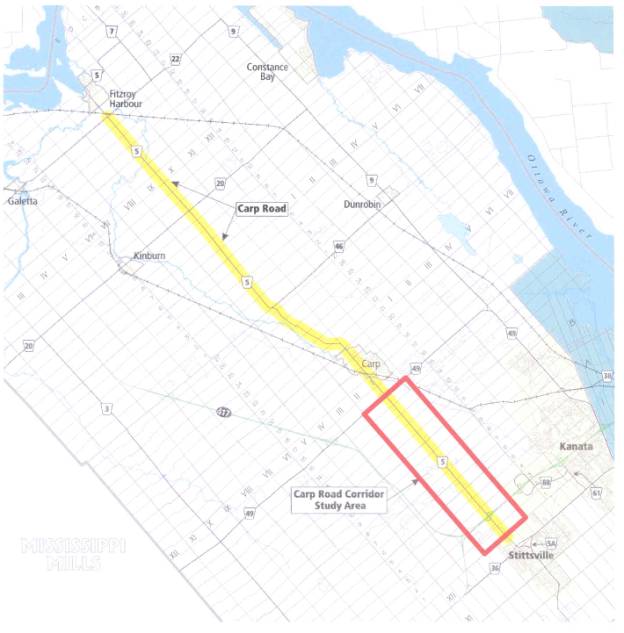
The Carp Road Corridor Study Area comprises the area bordered by Old Oak Creek Road to the east, William Mooney Road to the west, March Road to the north and Rothbourne Road to the south (see Document 1). The area contains a mix of uses including industrial commercial uses, residences, churches, a restaurant, quarry and a solid waste disposal site. One of the purposes of the Community Design Plan is to identify the lands within the Carp Road Corridor Study Area that should be reserved (designated) for future employment purposes.
The Carp Road Corridor is a unique rural employment area in Ottawa. Within this nine kilometer corridor, there is a concentration of rural employment, with more than 177 businesses employing 2500 people. The Corridor is strategically located as a rural employment area. It is just outside of the Urban Area and has excellent access to the Highway 417 interchange and the Carp Airport. Council recognized the importance of this area by requiring a Community Design Plan to be completed for the Carp Road Corridor with the results of the exercise being used to determine the boundaries of the Rural Employment Area and the policies associated with it incorporated by amendment to the Official Plan.
A collaborative community process was used to develop the Community Design Plan. Staff worked with the community to develop the vision and a strategy to address the Corridor's strengths, weaknesses, opportunities and threats on the Corridor. The Community Design Plan is a comprehensive plan for all of the lands in the Carp Road Corridor Study Area. It addresses development issues for the rural employment area as well as the surrounding area to ensure they develop in an integrated manner.
Official Plan Amendment:
The Community Design Plan has been completed and the boundary of the rural employment area has been identified as required by Section 2.5.7 of the Official Plan. Amendment xx designates the "Carp Road Corridor Rural Employment Area" and provides policies to reserve the Corridor land for future industrial/commercial development and ensure that the employment lands are protected by not allowing incompatible uses. The designation also provides recognition that this is an important rural employment area that will be supported by the City.
Community Design Plan:
The Community Design Plan is Council's plan of action for the Carp Road Corridor. It provides a framework to guide future development and addresses other issues that have been identified as concerns in the community. A Community Design Plan is different from a traditional Official Plan or Secondary Plan in that it is not approved as an Official Plan Amendment under the Planning Act and is not subject to appeal. Also its scope is much broader than simply land use. This plan has eight components:
1. Land Use Plan
Provides detailed land use policies to direct zoning.
2. Environmental Protection
Identifies environmental features and provides policies for their protection.
3. Servicing
Requires a study to be undertaken to assess water quality and quantity in the Corridor and monitor the results and assess the best ways to remedy any identified problems.
4. Road Improvements
Provides criteria for road/intersection improvements for Carp Road. Amends the Right- of Way Protection for the section of Carp Road from Richardson Side Road to the Stittsville urban boundary from 30 metres to 37.5 metres.
5. Marketing
Recommends that a local champion such as the West Ottawa Economic Development Association (WOEDA) develop a vision and marketing strategy for the Carp Road Corridor Rural Employment Area.
6. Visual Appearance
Provides design guidelines for new development and recommends specific actions/programs to improve the existing situation.
7. Land Use Compatibility
Provides guidelines to ensure that new development is compatible with existing residences.
8. Implementation
Provides a plan for implementation of the Community Design Plan.
Once the Community Design Plan is approved by Council, Annex 5 to the Official Plan will require revision to indicate that the Carp Road Corridor is subject to a Community Design Plan.
Official Plan Appeals:
1. The Official Plan Amendment and the Community Design Plan address the concern raised by Donna Neff in her appeal of the Official Plan related to the General Rural Area designation and policies as they relate to her property located at 2932 Carp Road. The Official Plan amendment changes the designation of the property to "Carp Road Corridor Rural Employment Area" and the Convenience Commercial Node designation in the Community Design Plan permits the property to be used for an office. These changes address the concerns raised in Ms. Neff's appeal to Official Plan and she is prepared to withdraw the appeal once the Official Plan Amendment and Community Design Plan are approved.
2. Novatech Engineering Consultants have filed an appeal on behalf of Luigi Mion, Tino Tolot, and Metcalfe Reality with respect to the land designations and applicable policies in the Ottawa Official Plan for the lands south of Highway 417 east of the Carp Road. They have requested that further consideration of these lands be deferred in the Community Design Plan until the Official Plan appeal process is exhausted. Consideration of the appropriate designation for this area has been deferred in the Community Design Plan as it will be determined through the appeal process for the Ottawa Official Plan.
ENVIRONMENTAL IMPLICATIONS
The Community Design
Plan contains policies to protect the environmental features that were
identified in the Carp River Watershed/Subwatershed Study. For example woodlots greater than 50 years
of age and areas of high groundwater recharge are identified on Schedule 2 of
the Community Design Plan and will be protected through the development review
process established in Section 4 of the Official Plan.
Some rural employment uses may include uses
that could pose a risk to groundwater resources however because of their nature
(large land requirements or use of local resources) are best located in the
rural area. From a groundwater
perspective, development must proceed with caution to ensure that it can be
accommodated within the groundwater system without affecting supplies available
to others. The Community Design Plan
provides policies that require development proposals where the land uses may
pose a high risk to the groundwater resource, or for uses that use large
volumes of water or dispose of large volumes of liquid or solid waste, to be
supported by a groundwater impact assessment.
RURAL IMPLICATIONS
Amendment xx designates the
"Carp Road Corridor Rural Employment Area". The Carp Road Corridor is an important rural employment area in
the City. Designation in the Official
Plan will give the Corridor more visibility and provide policies regarding
promotion and future development.
Other rural employment areas
are located in the "General Rural Area" designation in the Official
Plan. In these cases, the industrial
activity is limited to individual sites or business parks. The "General Rural Area"
designation provides adequate policies to address employment in these locations
in that it provides for a range of uses (including employment) subject to
specific criteria.
What makes the Carp Road
Corridor unique is the concentration of employment in one area (6 business
parks, 177 businesses, 2,500 jobs) which, due to its location, close to the
Urban Area, near a highway interchange and the Carp Airport, requires special
policies to address how the area will develop in the future. The Official Plan Amendment and the
Community Design Plan provide a specific comprehensive development strategy to
address future growth and development in the Corridor to ensure that the area
continues to grow and be a success as a rural employment area to support the
local economy.
CONSULTATION
A collaborative community
process was used to develop the Community Design Plan. Two workshops were held with focus groups in
the community to develop the vision and the strategies to achieve that vision.
A flyer was sent to all
landowners in the Corridor:
a) advising that a draft of the Community Design Plan was
available for review, and
b) extending an invitation to attend a community meeting to
discuss the Plan. The community meeting
was held at the Irish Hill Golf Course on March 11, 2004 with 56 people in
attendance. Everyone who attended the
community meeting has been advised of the Planning and Environment Committee
meeting.
Sixteen submissions with comments on the Community Design Plan
were received from the public. People
that provided comments were sent a response indicating how the issue/concern
raised has been addressed in the revised Plan.
Everyone who attended the community meeting on March 11 to discuss the
Community Design Plan has been advised of this meeting.
Councillor El-Chantiry is
aware of the Community Design Process
FINANCIAL IMPLICATIONS
Section 9.3 of the Community
Design Plan outlines the actions to achieve the objectives and assigns
responsibility for who will carry out the actions. Most policies will be implemented by the Planning and Development
Department through the development review process.
Recommended measures for
marketing and improving the visual appearance of the corridor (tree planting
program, coordinated signage, etc.) will be undertaken by a local champion such
as the West Ottawa Economic Development Association (WOEDA).
The Carp Road Corridor
Groundwater Study will be undertaken by the Planning and Development Department
at a cost of $53,950. Funds are
available in internal order no. 900408, Rural Servicing Strategy.
SUPPORTING DOCUMENTATION
Document 1 - Location Map
Document 2- Official Plan Amendment xx
Document 3 - Carp Road Corridor Community Design Plan (to be
distributed separately)
DISPOSITION
The Planning and Development Department will:
1. Issue the Notice of Decision with the 20 day appeal period for Amendment XX.
2. Revise Annex 5 to the Official Plan to indicate that the Carp Road Corridor is subject to a Community Design Plan.
AMENDMENT xx
OFFICIAL PLAN OF THE
CITY OF OTTAWA
PART A
– THE PREAMBLE
Purpose
The purpose of Amendment No.
xx is to designate the “Carp Road Corridor Rural Employment Area” on Schedule A
and to include policies in a new section (Section 3.7.5) to provide direction
for future land use and promotion of the Corridor as a rural employment area.
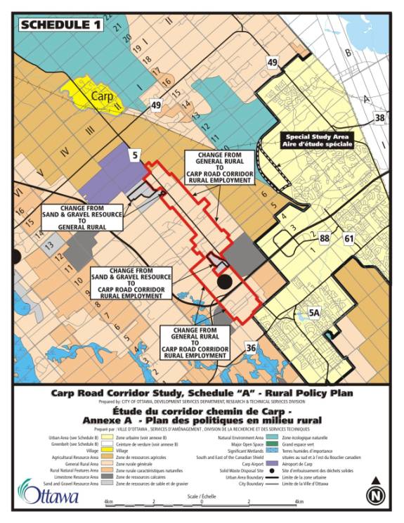
The amendment also changes
the designation of lands within the Carp Road Corridor, where the aggregate
resources has been depleted, from “Sand and Gravel Resource Area” to General
Rural Area” and “Carp Road Corridor Rural Employment Area”.
Basis
Carp Road extends from
Stittsville to Fitzroy Harbour. The
Carp Road Corridor is a significant rural employment area located in southern section
of the Carp Road between Carp and Stittsville.
It extends from Rothbourne Road in the south to March Road in the
north. Within this nine-kilometre
corridor there are 177 businesses employing more than 2500 people. It is the area where the former Township of
West Carleton’s industrial development is concentrated.
City Council recognizes the
need for a plan to support the Carp Road Corridor as a rural employment area
and made the completion of a Community Design Plan for the Corridor a priority.
The Ottawa Official Plan, Section
2.5.7, contains the following policy:
"The
Village of Carp and the Carp Road Corridor will be the subject of individual
Community Design exercises, both of which are to be completed by the end of
2003. The results of these exercises will be used to determined the boundaries
of the Rural Employment Area and the Policies associated with it and the
detailed land use designations for each of the areas that will be incorporated
by separate amendments into the Official Plan."
The Community Design Plan
(CDP) has been completed and it recommends that the Carp Road Corridor Rural
Employment Area be designated in the Ottawa Official Plan with specific
policies to protect the corridor for future rural employment use. This amendment to the Ottawa Official Plan
implements the recommendations of the CDP.
With its collection of
service, manufacturing and other industrial uses, the Carp Road Corridor has
the potential to significantly contribute to the City’s rural economy. It can
do so by continuing to support rural industries and by evolving as a business
area for enterprises specializing in environmental and aggregate technologies
as well as high tech industry.
Within the Carp Road
Corridor there are sites designated “Sand and Gravel Resource Area” where the
aggregate resources have been depleted and the pit license has been surrendered
to the Ministry of Natural Resources.
These sites no longer require protection for future aggregate extraction. Theses areas are more appropriately
designated as “General Rural Area” and “Carp Road Corridor Rural Employment
Area” as shown on Schedule 1.
The Right-of- way (ROW) for
Carp Road within the Carp Road Corridor study area is protected for 30 metres
in the Official Plan. During the Community
Design Plan exercise it was determined that a wider ROW of 37.5 metres was
required for the southern section of Carp Road, from the Stittsville Urban
Boundary to Richardson Side Road, to address future road requirements to
accommodate traffic volume/safety near the Highway 417 interchange.
THE AMENDMENT
Schedule A, Rural Policy
Plan, is hereby amended by replacing the “General Rural Area” and “Sand and
Gravel Resource Area designation with a new designation, “Carp Road Corridor
Rural Employment Area” as shown on Schedule 1.
1. Section 3.7 is
hereby amended by adding a new Section 3.7.5, “Carp Road Corridor Rural
Employment Area” as follows:
3.7.5 Carp Road
Corridor Rural Employment Area
Due to its
strategic location and accessibility (anchored by the Highway 417 interchange
in the south and the Carp Airport in the north), the Carp Road Corridor Rural
Employment Area offers a unique and diverse range of employment and industrial
opportunities. This is evident with the
presence of a full range of industry sectors, which includes, but is not
limited to, manufacturing, mining (aggregates), retail trade, construction,
agriculture, transportation as well as personal, professional and business
services. Also, new industries such as
high technology businesses, environmental services, some value-added
processing, wood and metal fabrication, and other activities choosing to
relocate in rural employment areas will add to the diversification of both the
urban and rural economies. The Carp
Road Corridor provides opportunities for attracting industries that favour
large amounts of land and the openness of a more rural site.
The Carp Road
Corridor Rural Employment Area plays an important role in the development and
well-being of the local economy. The
diversity and the ability to attract a wide variety of industries has been one
of the strengths of the Corridor. In
order to remain successful in the future, this area must maintain the ability
to allow for a diverse range of industrial uses while developing an appealing
environment for those new industries willing to expand or relocate.
Policies
1. The “Carp Road
Corridor Rural Employment Area” is designated on Schedule A with the intent to
reserve the land for rural industrial and commercial uses;
2. New development applications
will conform to the policies in the Community Design Plan;
3. The Community
Design Plan for the Carp Road Corridor shall provide direction to the zoning by-law for future land uses;
4. New industrial development will generally be by way
of plans of subdivision/business parks;
2. Schedule A is
hereby amended as follows:
a. The areas
designated “General Rural Area” and “Sand and Gravel Resource Area” are changed
to “Carp Road Corridor Rural Employment Area” as shown on Schedule 1
b. The areas
designated “Sand and Gravel Resource Area” are changed to “General Rural Area”
as shown on Schedule 1
3. Annex 1, Table 3 – Rural Arterials – Existing
and Proposed (Location Defined) is amended as follows:
a. In the third Road
listing for Carp, the words “Urban Area Limit” are changed to “Richardson Side
Road”
b. A new fourth Road
listing is added for Carp to read “Carp” From “Richardson Side Road” To “Urban
Area Limit” with a ROW to be protected for “37.5” metres