5. OFFICIAL PLAN AND ZONING - 701-711 mONTREAL rOAD PLAN OFFICIEL ET ZONAGE
- 701-711, CHEMIN DE MONTRÉAL |
COMMITTEE RECOMMENDATIONS
That Council:
1. approve and adopt an
amendment to Schedule B of Volume 1 of the Council Adopted Official Plan of the
City of Ottawa to redesignate 701-711 Montreal Road, the Montfort Woods, from
General Urban Area to Urban Natural Features, as detailed in Document 2.
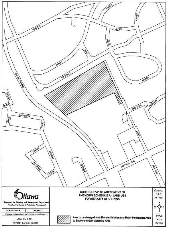
2. approve and adopt an amendment to Schedule B of Volume I of the Official Plan of the former City of Ottawa to redesignate 701-711 Montreal Road, the Montfort Woods, from Residential Area and Major Institutional Area to Environmentally Sensitive Area, as detailed in Document 3.
3. approve
the application to amend the former City of Ottawa Zoning By-law, 1998, for
701-711 Montreal Road, the Montfort Woods, from L3[698] - Community Leisure
Zone and I2 F(1.5) - Major Institutional Zone to an ES - Environmentally
Sensitive Area Zone, as shown in Document 1.
RECOMMANDATIONS DU COMITÉ
Que le Conseil :
1. approuve
et adopte une modification à l'annexe B du volume 1 du Plan officiel de la
Ville d'Ottawa, que le Conseil a adopté, afin de faire passer la désignation du
701-711, chemin de Montréal (Boisé Montfort) de « zone urbaine générale », à «
caractéristiques naturelles urbaines », comme le précise le document 2.
2. approuve
et adopte une modification à l'annexe B du volume I du Plan officiel de
l'ancienne Ville d'Ottawa, afin de faire passer la désignation du 701-711,
chemin de Montréal (Boisé Montfort) de « zone résidentielle » et « zone de
grandes institutions » à « zone écologiquement vulnérable », comme le précise
le document 3.
3. approuve la demande visant à modifier
le Règlement de zonage de 1998 de l'ancienne Ville d'Ottawa afin de faire
passer la désignation du 701-711, chemin de Montréal (Boisé Montfort) de
L3[698] - Zone de loisirs communautaire et I2 F(1.5) - Zone de grandes
institutions à ES - Zone écologiquement vulnérable, comme le précise le
document 1.
Documentation
1. Planning and Growth Management Deputy
City Manager’s report dated 29 June 2004 (ACS2004-DEV-APR-0139).
2.
Extract of Draft
Minutes, 24 August 2004.
Report to/Rapport
au :
Planning
and Environment Committee
Comité de l'urbanisme et de l'environnement
and Council / et au Conseil
29 June 2004 / le 29 juin 2004
Submitted by/Soumis par : Ned
Lathrop, Deputy City Manager / Directeur municipal adjoint
Planning and Growth Management / Urbanisme et Gestion de la croissance
Contact Person/Personne ressource : Grant Lindsay,
Manager / Gestionnaire
Development
Approvals / Approbation des demandes d'aménagement
(613)
580-2424 x13242, Grant.Lindsay@ottawa.ca
REPORT RECOMMENDATIONS
That the Planning and
Environment Committee recommend that Council:
1. approve and adopt an amendment to Schedule B of Volume 1 of
the Council Adopted Official Plan of the City of Ottawa to redesignate 701-711
Montreal Road, the Montfort Woods, from General Urban Area to Urban Natural
Features, as detailed in Document 2.
2. approve and adopt an amendment to Schedule B of Volume I of
the Official Plan of the former City of Ottawa to redesignate 701-711 Montreal
Road, the Montfort Woods, from Residential Area and Major Institutional Area to
Environmentally Sensitive Area, as detailed in Document 3.
3. approve the application to amend the former City of Ottawa
Zoning By-law, 1998, for 701-711 Montreal Road, the Montfort Woods, from
L3[698] - Community Leisure Zone and I2 F(1.5) - Major Institutional Zone to an
ES - Environmentally Sensitive Area Zone, as shown in Document 1.
RECOMMANDATIONS DU RAPPORT
Que le Comité de l'urbanisme
et de l'environnement recommande au Conseil :
1. d'approuver et d'adopter une modification à l'annexe B du
volume 1 du Plan officiel de la Ville d'Ottawa, que le Conseil a adopté, afin
de faire passer la désignation du 701-711, chemin de Montréal (Boisé Montfort)
de " zone urbaine générale ", à " caractéristiques naturelles
urbaines ", comme le précise le document 2.
2. d'approuver et d'adopter une modification à l'annexe B du
volume I du Plan officiel de l'ancienne Ville d'Ottawa, afin de faire passer la
désignation du 701-711, chemin de Montréal (Boisé Montfort) de " zone
résidentielle " et " zone de grandes institutions " à "
zone écologiquement vulnérable ", comme le précise le document 3.
3. d'approuver la demande visant à modifier le Règlement de
zonage de 1998 de l'ancienne Ville d'Ottawa afin de faire passer la désignation
du 701-711, chemin de Montréal (Boisé Montfort) de L3[698] - Zone de loisirs
communautaire et I2 F(1.5) - Zone de grandes institutions à ES - Zone
écologiquement vulnérable, comme le précise le document 1.
BACKGROUND
The site is situated behind
the Montfort Hospital with partial frontage on Lang's Road to the east.
The site, known as the
Montfort Woods, is a natural woodlot that is surrounded by the Montfort
Hospital and long-term care facility to the south, Aviation Parkway to the
west, CFB Rockcliffe to the north and the Fairhaven community to the east. The site is approximately 7 hectares in
size.
The National Capital
Commission (NCC) acquired the Montfort Woods property on January 27, 2004, and
has submitted Official Plan and Zoning By-law amendments to establish an Urban
Natural Features designation and Environmentally Sensitive Area designation
under the new City of Ottawa and former City of Ottawa Official Plans,
respectively, and to establish an ES- Environmentally Sensitive zone for the
Woods. These changes reflect the NCC's
intention that the Montfort Woods receive the highest level of natural area
protection afforded by the City of Ottawa Official Plan and Zoning By-law. The NCC indicated in their application forms
that the Montfort Woods would be used for conservation, educational,
interpretation, scientific and passive leisure activity. They stated that the land would be
maintained in its natural state for future generations to enjoy. The NCC indicated that the Montfort Woods
has been designated as part of the National Interest Land Mass, which provides
for long-term ownership by the NCC.
This designation has been approved by the Treasury Board. The NCC is also intending to amend the Plan
for Canada's Capital (PFCC) to reflect
the addition of the Montfort Woods to Federal ownership. The intended designation will be
"Natural Heritage Area" the most protective designation in the PFCC.
It has been determined that a small area of the Montfort Woods
measuring approximately 20 x 20 metres is located within the I2 F(1.50) zone
that has an Official Plan designation of Major Institutional Area in the
Official Plan of the former City of
Ottawa. This amendment will
ensure that this small area is captured in the amendments and has the identical
Official Plan and zoning designations as the balance of the Montfort Woods
landholding that is zoned L3[698].
DISCUSSION
OFFICIAL PLAN AMENDMENTS
The former Regional Official
Plan designated the subject property as General Urban Area. The City Council Adopted Official Plan also
designates the subject property as General Urban Area. Lands having this designation are generally
expected to develop with a wide range of residential uses as well as
employment, service, cultural, leisure, entertainment and institutional
uses.
The former City of Ottawa
Official Plan designated these lands Residential Area (as stated above, a small
portion of the site also contains a Major Institutional Official Plan
designation). Lands having this
designation are expected to include a full range of dwelling types from
single-detached to apartment dwellings.
City Council shall encourage the achievement of a diversity and variety
of land use and activity within this designation by permitting neighbourhood
serving uses, and non-residential uses, subject to provisions etc.
Applications for residential
and mixed use development had been received on the subject lands in the past,
but had been rejected for numerous planning reasons, including the significant
woodlot on the site. The Montfort Woods was studied through the
former City of Ottawa's Natural and Open Spaces Study (NOSS), which established
the relative environmental values of all natural features city-wide. The Montfort Woods was identified as
significant and worthy of protection through this study. However,
appropriate Official Plan Amendments and Zoning By-law amendments were
not brought forward by the former City of Ottawa as the lands were zoned to
permit development and were privately owned.
The Urban Natural Areas Environmental Evaluation Study will update the
NOSS for all of urban amalgamated Ottawa, and will likely confirm the NOSS
results for this site. Recent passage
into ownership by the NCC will ensure that Montfort Woods is retained for
protection and conservation for future generations.
Montfort Woods contains a
number of natural features and values that provide a valuable contribution to
biodiversity and wildlife habitat in the urban area to be enjoyed by all Ottawa
residents. The Montfort Woods is
particularly striking due to it's extent, quality, maturity of the trees
growing within this landscape and accessibility to the community
Amending the designation on
the subject property to Urban Natural Features in the Council Adopted Official
Plan and to Environmentally Sensitive Area in the former Official Plan of the
City of Ottawa is consistent with the results of NOSS for the Montfort
Woods. Both the Urban Natural Features
and Environmentally Sensitive Areas designations will ensure the protection,
conservation and the enhancement of the Montfort Woods. Such designations strictly control
development and activity in order to sustain and enhance the integrity of the
natural environment. Additionally,
protection of the Woods contributes toward fulfillment of Policy 2.4.5.1b) of
the Council Adopted Official Plan target of maintaining 30% forest cover within
the City (Official Plan Policy 2.4.5.1. b).
Furthermore, amending the
designation on the subject property parallels those steps presently completed
by the NCC to designate the Montfort Woods as a "Natural Heritage
Area" which is the most protective designation in the PFCC, as well as
parallels new steps/initiatives by the NCC for creating specific policies and
recommendations for the Montfort Woods within the Urban Lands Master Plan.
Finally, the new designation
will reflect the NCC's intended use of these lands for conservation,
educational, interpretation, scientific and passive leisure activity. The lands will remain in their natural state
and will be accessible for the use of Ottawa residents and others. The residents of the adjacent Fairhaven Way,
Lang's Road and Greenhill Way have taken considerable interest in these Woods
over the years and have informed staff that, in order to ensure the long-term
protection, cleanliness and survival of this urban natural feature, they are
willing to contribute with the annual clean up of litter and garbage, as well
as report any suspicious acts or vandalism to ensure the Montfort Woods remains
ecologically healthy, pristine and safe.
ZONING BY-LAW AMENDMENT
The majority of the Woods is
currently zoned L3 [698] - Community Leisure Zone that permits a variety of
public uses. As stated earlier in this
report, a small 20x20 metres area is Zoned I2 F(1.5) which is a Major
Institutional Area Zone.
Staff is supporting the
rezoning of the Montfort Woods to an ES - Environmentally Sensitive Zone. No uses and no buildings are permitted in
this zone designation. The proposed
Zoning By-law amendment will complete the amendment approval process by
providing the highest level of zoning protection for this wood lot. The findings of the NOSS study and the
evidence of the existing natural features/values on this property have
determined that an ES zone is the most desirable and suitable zoning to be
applied for these lands to ensure their long-term protection and ecological
health.
ENVIRONMENTAL IMPLICATIONS
The proposed amendments will
provide the highest form of environmental protection under the Official Plan
and Zoning By-law for an area deemed to have significant environmental value.
CONSULTATION
Notice of this application
was carried out in accordance with the City's Public Notification and
Consultation Policy. Information signs were posted on-site indicating the
nature of the application. The Ward
Councillor is aware of this application and the staff recommendation. The City did not receive any negative
comments or opposition to this application.
Six letters/emails in support of the application were received. Detailed comments are provided in Document
5.
FINANCIAL IMPLICATIONS
N/A
APPLICATION PROCESS TIMELINE
STATUS
This application was
processed within the timeframe established for the processing of Official Plan
and Zoning By-law amendments.
SUPPORTING
DOCUMENTATION
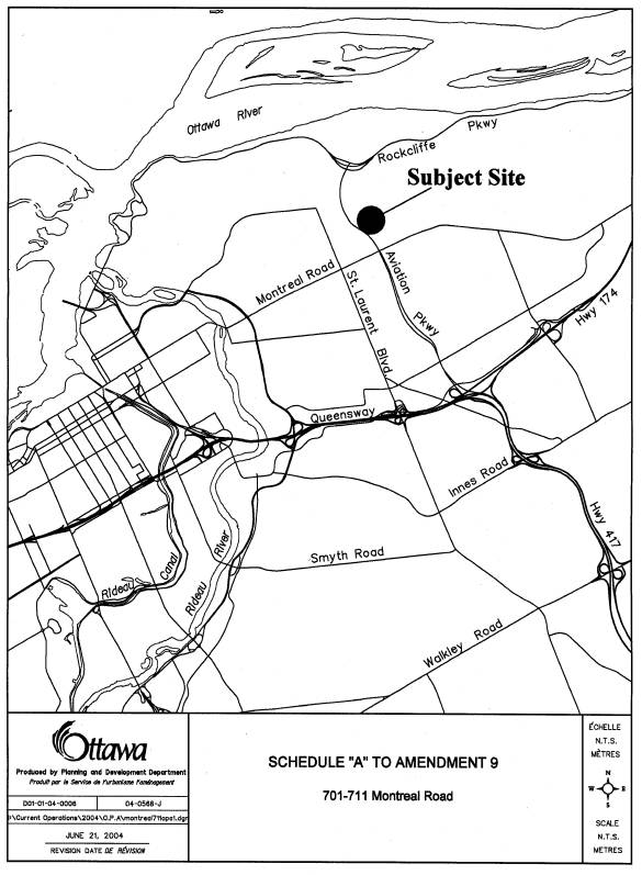
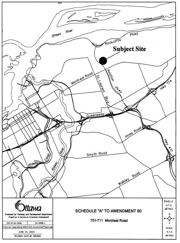
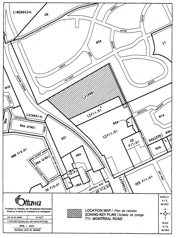
Document 1 Location
Map
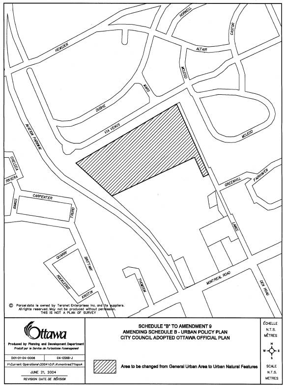
Document 2 Proposed
Amendment to the Council Adopted Official Plan
Document 3 Proposed
Amendment to the Official Plan of the former City of Ottawa
Document 4 Explanatory
Note
Document 5 Consultation
Details
DISPOSITION
Department of Corporate
Services, Secretariat Services to notify the owner (National Capital
Commission, 202-40 Elgin Street, Ottawa, Ontario, K1P 1C7, Attention: Richard
Scott), All Signs, 8692 Russell Road, Navan, ON K4B 1J1, and the Program Manager, Assessment, Department of
Corporate Services of City Council's decision.
Department of Planning and
Development to prepare the implementing by-laws and forward to Legal Services
Branch, and undertake the statutory notification of the Official Plan Amendments
and for the amendment to the Zoning By-Law 1998, of the former City of Ottawa.
Department of Corporate
Services, Legal Services Branch to forward the by-laws to adopt the Official
Plan Amendments and to implement the zoning changes to City Council.
LOCATION MAP Document
1
PROPOSED OFFICIAL PLAN
AMENDMENT Document
2
Official Plan
Amendment 9/Modifications du Plan Directeur 9
To the Official
Plan of the City of Ottawa
Land Use
Utilisation du
sol
________________________________________________________________________
INDEX
________________________________________________________________________
The Statement of
Components
PART A - THE
PREAMBLE
Purpose
Location
Basis
PART B- THE
AMENDMENT
Introductory
Statement
Details of the
Amendment
PART C - APPENDIX
Appendices
THE STATEMENT OF
COMPONENTS
PART A - THE
PREAMBLE, introduces the actual Amendment but does not constitute part of
Amendment No. 9 to the City of Ottawa Official Plan.
PART B - THE
AMENDMENT, consisting of the following text and maps constitutes the actual
Amendment No. 9 to the City of Ottawa Official Plan.
PART C - THE
APPENDIX, does not form part of the Amendment but is provided to clarify the
intent and to supply background information related to the Amendment.
PART A - THE PREAMBLE
1.0 Purpose
The subject
property at 701-711 Montreal Road is
presently designated General Urban Area on Schedule B of the City Council
Adopted Official Plan. The purpose of
Amendment No. 9 is to amend the land use designation for the subject property
to Urban Natural Features. The subject
amendment constitutes a map change only.
2.0 Location
The lands
affected by the amendment are located north of the Montfort Hospital and a
long-term care facility, east of the Aviation Parkway, south of the CFB
Rockcliffe lands and west of the Fairhaven community. The lands are approximately 7 hectares in area.
3.0 Basis
3.1 Background
The affected
parcel of land consists of a core and marginal woodland area that includes
predominantly Sugar Maple, Beech, Ash, Basswood, and Norway Maple over
limestone bedrock.. The applicant, the
National Capital Commission (NCC), wishes to protect this wood lot for future
generations.
3.2 Context of
Amendment
The applicant is
requesting changes to Schedule B, Urban Policy Plan. The property is presently designated General Urban Area and will
be amended to Urban Natural Features.
Lands designated
Natural Urban Features are natural landscapes that include woodlands, wetlands,
watercourses and ravines. The existing
natural environment on site consists of a core mature woodland that is
exceptional within the former City of Ottawa due to the large average tree
size, area of cover, abundance of wildlife nesting sites, and diversity within
sub-canopy trees. Aerial photographs
from 1928 indicate that the core sugar maple portion of the woods has never
been cleared. The Woods are also
interesting from a landform perspective.
A portion of an elevated plateau within the site, where the limestone
bedrock is exposed, shows well-developed karst topography. Karst is a distinctive topography and
appears as smooth, rounded depressions in the bedrock. The Montfort Woods example is particularly
striking due to it's extent, quality, maturity of trees growing within this
landscape and it's accessibility to the community. This natural landscape, therefore, provides a valuable
contribution to biodiversity and wildlife habitat in the urban area to be
enjoyed by Ottawa residents and others.
The NCC has acquired these lands and wishes to use the Woods for conservation,
educational, interpretation, scientific and passive leisure uses. These uses meet the objectives of a Natural
Urban Features designation in ensuring that the highest level of protection is
provided for the existing natural features occurring at this location. The current designation does not reflect the
natural state of the site and is inappropriate for a wood lot that scored high
as a natural woodland in the Natural and Open Spaces Study (NOSS); the latter
completed by the former City of Ottawa.
Under the ownership of the NCC these lands will never be built upon and
will be designated a "Natural Heritage Area" the most protective
designation in the Plan for Canada's Capital (PFCC). Additionally, the protection of the Woods contributes toward
fulfillment of Policy 2.4.5.1b) of the Council Adopted Official Plan target of
maintaining 30% forest cover within the City (Policy 2.4.5.1b)).
Given the
foregoing context, it is appropriate and desirable to redesignate the land
Urban Natural Area to allow the Montfort Woods to be protected in their natural
state for the use and enjoyment of residents today and of future generations.
PART B - THE
AMENDMENT
1.0 The
Introductory Statement
All of this part
of the document entitled Part B - The Amendment, consisting of the following
text and schedule included as Schedule "B", constitutes Amendment No.
9 to the City of Ottawa Official Plan.
2.0 Details of
Amendment
The City of
Ottawa Official Plan is hereby amended as follows:
2.1 The
Official Plan - Schedule B - Urban Policy Plan is amended to include the
following changes shown on Schedule "B" attached hereto:
I) Redesignate the lands located north of the
Montfort Hospital, east of the Aviation Parkway, south of CFB Rockcliffe and
west of the Fairhaven community from General Urban Area to Urban Natural
Features.
PART C - THE
APPENDIX
N/A