6. AMENDMENTS TO THE 2003 OTTAWA OFFICIAL PLAN -- MINOR
POLICY CHANGES AND CORRECTIONS
MODIFICATIONS AU PLAN
OFFICIEL D’OTTAWA DE 2003 –MODIFICATIONS DE POLITIQUE MINEURES ET CORRECTIONS
|
COMMITTEE RECOMMENDATIONS AS AMENDED
That Council approve:
1. an Official Plan Amendment to make
minor policy changes in response to appeals of the 2003 Ottawa Official Plan,
as shown in Document 1 attached,
2. an Official Plan Amendment to make other minor policy
changes to the 2003 Ottawa Official Plan, as shown in Document 2 attached,
3. an Official Plan Amendment to correct errors in the 2003
Ottawa Official Plan and make editorial changes, as shown in Document 3
attached, subject to the following
amendments:
i.
That in item 11, the words
“Provisions for Retail” be deleted and “General Urban Area” be inserted in
their place, to correct a reference to an Official Plan section;
ii.
That a new item 12 be inserted
after item 11, that states “Section 3.6.7 Major Urban Facilities is hereby
amended by deleting the words ‘Lot 24’ and inserting the words ‘Lot 25’ in
policy 3”;
iii.
That in item 25, the words “Section
4.7” be deleted and “Section 4.8” be inserted in their place, to correct a
reference to an Official Plan section;
iv.
That
a new item 31 be inserted after item 30, that states “Schedule F – Central
Area/Inner City Road Network is hereby amended by changing the designation of
the Arterial – Proposed (Alignment Defined) in LeBreton Flats to Arterial –
Existing, inserting the new street name ‘Wellington’, deleting the existing
road and name ‘Ottawa River Parkway’, deleting the existing road name
‘Wellington’ and changing the road name ‘Scott’ to ‘Albert’, as shown in Schedule 7 attached”;
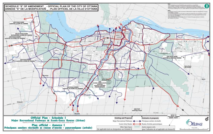
v.
That
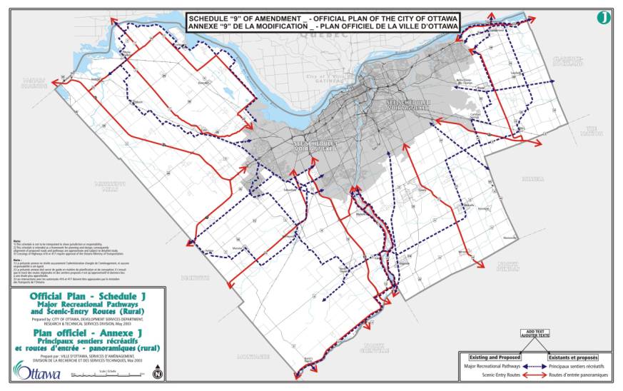
a new section d) be inserted to item 32 that states “deleting the Scenic-Entry
Route designation of Bronson Avenue north of Albert Street and inserting a
Scenic-Entry Route on Albert and Commissioner Streets between Bronson Avenue
and Booth Street, and on Booth Street from Albert north to the Chaudière
Bridge, as shown in Schedule 9 attached.”
vi.
That
a new section e) be inserted to item 32 that states “deleting the Ottawa River
Parkway and Scenic-Entry Route designation in LeBreton Flats and adding the new
portion of Wellington and a Scenic-Entry Route designation west of the Portage Bridge,
as shown on Schedule 9 attached”.
vii.
That
the section numbers and schedule numbers be amended appropriately.
4. an Official Plan Amendment to correct and make minor policy
changes to Annex 1 regarding road classifications and rights-of-way, as shown
in Document 4 attached, subject to the following amendments
i.
That the existing item 7 clause g) be modified by
replacing the word “Richmond” with the words “Wellington St. West”.
ii.
That the existing item 7 clause j) be modified by
replacing the two references to the word “Wellington” with the word “Albert”.
iii.
That the existing item 7 clause k) be deleted and
replaced with the following: “In the ROW listing for Wellington/Albert Street
between Champagne and Booth the words
‘Wellington/Albert’ be replaced with ‘Albert’ and the word ‘Champagne’ be changed to ‘Champagne
North’.”
iv.
That a new clause l) be inserted to item 7 that
states “In the ROW listing for Albert/Wellington between Booth and Empress that
the words ‘Albert/Wellington’ be replaced with the word ‘Albert’.”
v.
That a new clause m) be inserted to item 7 that
states “In the ROW listing for Richmond Road between Golden and Terminus at
Western that the words ‘Terminus at Western’ be replaced with the words ‘Island
Park’.”
vi.
That a new clause n) be inserted to item 7 that
states “In the ROW listing for Wellington Street between Western and Terminus
at Somerset that the word ‘Wellington’ be replaced with the words ‘Wellington
St. West’ and that the word ‘Western’ be replaced with the words ‘Island
Park’.”
vii.
That a new clause o) be inserted to item 7 that
states “In the ROW listing for Parkdale Avenue between Ottawa River Parkway and
Richmond that the word ‘Richmond’ be replaced with the word ‘Wellington St.
West’.”
viii.
That a new clause p) be inserted to item 7 that
states “In the ROW listing for Wellington between Proposed Lebreton and Rideau
that the words ‘Proposed Lebreton’ be replaced with the words ‘Portage
Bridge’.”
ix.
That a new clause q) be inserted to item 7 that
states “A new ROW listing be added for Wellington Street to read ‘Wellington’
from ‘Ottawa River Parkway’ to ‘Portage Bridge’ with a ROW to be protected of
‘40m’.”
x.
That a new clause g) be added to item 8 that states
“The ROW for LeBreton (proposed new boulevard) be deleted in its entirety.”
xi.
That a new clause h) be added to item 8 that states
“In the ROW for Preston extension the word ‘Wellington’ be replaced with the
word ‘Albert’ and that the words ‘Proposed Lebreton Blvd.’ be replaced with the
word ‘Wellington’.”
xii.
That a new clause lll) be added to item 19 that
states “In the ROW listing for McCormick Street the word ‘Wellington’ be
replaced with ‘Wellington St. West’.”
xiii.
That the section numbers numbers be amended
appropriately.
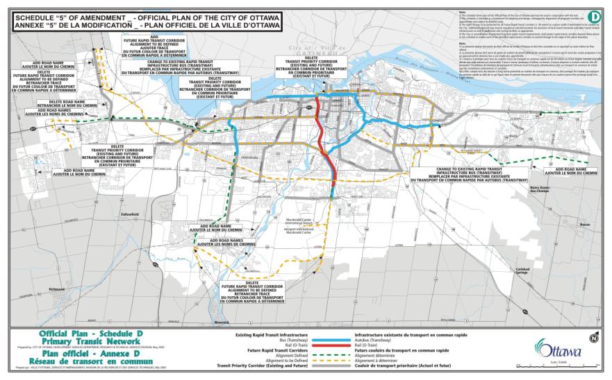
5. That
the deletion to Schedule 5 regarding the “Future Rapid Transit Corridor
Alignment to be defined” extending south of Leitrim be retained.
RECOMMANDATIONS MODIFIées DU COMITÉ
Que le Conseil approuve :
1. une
modification au Plan officiel afin d’apporter des modifications de politique
mineures à la suite d’appels interjetés au sujet du Plan officiel d’Ottawa de
2003, comme il est indiqué dans le Document 1 ci-joint;
2. une
modification au Plan officiel afin d’apporter d’autres modifications de
politique mineures au Plan officiel d’Ottawa de 2003, comme il est indiqué dans
le Document 2 ci-joint;
3. une
modification au Plan officiel afin de corriger des erreurs relevées dans le
Plan officiel d’Ottawa de 2003 et d’apporter des changements de forme, comme il
est indiqué dans le Document 3 ci-joint, sous réserve des modifications
suivantes :
i.
Que, à
l’article 11, les mots « Commerce de détail » soient supprimés et
remplacés par « Aire urbaine générale », afin de corriger un renvoi à
une section du Plan officiel;
ii.
Qu’un
nouvel article 12 soit inséré à la suite de l’article 11, et stipule « La
section 3.6.7, Grandes installations urbaines, est par la présente modifiée par
la suppression des mots ‘Lot 24’ et par l’ajout des mots ‘Lot 25’ à la
politique 3 »;
iii.
Que, à
l’article 25, les mots « Section 4.7 » soient supprimés et remplacés
par les mots « Section 4.8 », afin de corriger un renvoi à une
section du Plan officiel;
iv.
Qu’un nouvel article 31 soit inséré à la suite de l’article 30, et stipule « L’annexe F, Aire
centrale/réseau de routes du centre-ville, est par la présente modifiée par le
changement de la désignation Artère proposée (tracé défini) aux plaines
LeBreton en Artère, existante, par l’ajout du nouveau nom de rue ‘Wellington’,
par la suppression de la route existante et du nom ‘promenade de l’Outaouais’,
par la suppression du nom de rue actuel ‘Wellington’ et par le changement du
nom de rue ‘Scott’ par ‘Albert’, tel qu’illustré dans l’annexe 7
ci-jointe »;
v.
Qu’une nouvelle section d) soit ajoutée à l’article
32 et stipule « supprimer la désignation de route panoramique et route
d’entrée de l’avenue Bronson au nord de la rue Albert et ajouter la désignation
de route panoramique et route d’entrée sur les rues Albert et Commissioner,
entre l’avenue Bronson et la rue Booth, et sur la rue Booth, à partir d’Albert
au nord du pont des Chaudières, tel qu’illustré dans l’annexe 9
ci-jointe ».
vi.
Qu’une nouvelle section e) soit ajoutée à l’article
32 et stipule « supprimer la désignation de promenade de l’Outaouais et de
route panoramique et route d’entrée aux plaines LeBreton, et ajouter la
nouvelle partie de Wellington et une désignation de route panoramique et route
d’entrée à l’ouest du pont du Portage, tel qu’illustré dans l’annexe 9
ci-jointe ».
vii.
Que les numéros de sections et d’annexes soient
modifiés en conséquence.
4. une
modification au Plan officiel afin d’apporter des corrections et des
modifications de politique mineures à l’Annexe 1
concernant les classifications routières et les emprises, comme il est indiqué
dans le Document 4 ci-joint, sous réserve des
modifications suivantes :
i.
Que la clause g) de l’article 7
actuel soit modifiée en remplaçant le mot « Richmond » par les mots
« rue Wellington Ouest ».
ii.
Que la clause j) de l’article 7
actuel soit modifiée en remplaçant les deux renvois au mot
« Wellington » par le mot « Albert ».
iii.
Que la clause k) de l’article 7
actuel soit supprimée et remplacée par la mention suivante : « Dans
la liste des emprises des rues Wellington/Albert, entre Champagne et Booth, que
les mots ‘Wellington/Albert’ soient remplacés par ‘Albert’ et que le mot ‘Champagne’ soit modifié en ‘Champagne
Nord’. »
iv.
Qu’une nouvelle clause l) soit
ajoutée à l’article 7 et stipule « Dans la liste des emprises des rues
Albert/Wellington, entre Booth et Empress, que les mots ‘Albert/Wellington’
soient remplacés par le mot ‘Albert’. »
v.
Qu’une nouvelle clause m) soit
ajoutée à l’article 7 et stipule « Dans la liste des emprises du chemin
Richmond, entre Golden et Terminus à la hauteur de Western, que les mots
‘Terminus à la hauteur de Western’ soient remplacés par les mots ‘Island
Park’. »
vi.
Qu’une nouvelle clause n) soit
ajoutée à l’article 7 et stipule « Dans la liste des emprises de la rue
Wellington, entre Western et Terminus à la hauteur de Somerset, que le mot
‘Wellington’ soit remplacé par les mots ‘Wellington Ouest’ et que le mot
‘Western’ soit remplacé par les mots ‘Island Park’. »
vii.
Qu’une nouvelle clause o) soit
ajoutée à l’article 7 et stipule « Dans la liste des emprises de l’avenue
Parkdale, entre la promenade des Outaouais et Richmond, que le mot ‘Richmond’
soit remplacé par les mots ‘la rue Wellington Ouest’. »
viii.
Qu’une nouvelle clause p) soit
ajoutée à l’article 7 et stipule « Dans la liste des emprises de
Wellington, entre Lebreton proposé et Rideau, que les mots ‘Lebreton proposé’
soient remplacés par les mots ‘pont du Portage’. »
ix.
Qu’une nouvelle clause q) soit
ajoutée à l’article 7 et stipule « Qu’une nouvelle liste des emprises soit
ajoutée à la rue Wellington de manière à mentionner ‘Wellington’ entre la
‘promenade des Outaouais’ et le ‘pont du Portage’ avec une emprise protégée de
’40 m’. »
x.
Qu’une nouvelle clause g) soit
ajoutée à l’article 8 et stipule « Que l’emprise de LeBreton (nouveau
boulevard proposé) soit supprimée dans son intégralité. »
xi.
Qu’une nouvelle clause h) soit
ajoutée à l’article 8 et stipule « Que, dans l’emprise du prolongement de
Preston, le mot ‘Wellington’ soit remplacé par le mot ‘Albert’ et que les mots
‘boul. Lebreton proposé’ soient remplacés par le mot ‘Wellington’. »
xii.
Qu’une nouvelle clause lll)
soit ajoutée à l’article 19 et stipule « Que, dans la liste des emprises
de la rue McCormick, le mot ‘Wellington’ soit remplacé par les mots ‘Wellington
Ouest’. »
xiii.
Que les numéros de sections
soient modifiés en conséquence.
5.
Que la suppression faite à
l’annexe 5 concernant le « tracé du couloir futur de transport en commun
rapide à définir » se prolongeant au sud de Leitrim soit maintenue.
Documentation
1. Planning
and Growth Management Deputy City Manager’s report dated 12 July 2004
(ACS2004-DEV-POL-0035).
2.
Extract of Draft Minutes, 24 August 2004.
Report to/Rapport
au :
Planning
and Environment Committee
Comité de l'urbanisme et de l'environnement
and Council / et au Conseil
12 July 2004 / le 12 juillet
2004
Submitted
by/Soumis par : Ned Lathrop, Deputy City Manager /
Directeur municipal adjoint
Planning
and Growth Management / Urbanisme et Gestion de la croissance
Contact Person/Personne ressource : Richard
Kilstrom, Manager / Gestionnaire,
Community
Design / Conception de communauté
(613)
580-2424 x22653, Richard.Kilstrom@ottawa.ca
|
|
Ref N°: ACS2004-DEV-POL-0035
|
|
SUBJECT:
|
AMENDMENTS TO THE 2003 OTTAWA OFFICIAL PLAN --
MINOR POLICY CHANGES AND CORRECTIONS
|
|
|
|
|
OBJET
:
|
MODIFICATIONS AU PLAN OFFICIEL
D'OTTAWA DE 2003 -MODIFICATIONS DE POLITIQUE MINEURES ET CORRECTIONS
|
REPORT
RECOMMENDATIONS
That Planning and Environment Committee recommend that Council
approve:
1. an Official Plan
Amendment to make minor policy changes in response to appeals of the 2003
Ottawa Official Plan, as shown in Document 1 attached,
2. an Official Plan
Amendment to make other minor policy changes to the 2003 Ottawa Official Plan,
as shown in Document 2 attached,
3. an Official Plan
Amendment to correct errors in the 2003 Ottawa Official Plan and make editorial
changes, as shown in Document 3 attached, and
4. an Official Plan
Amendment to correct and make minor policy changes to Annex 1 regarding road
classifications and rights-of-way, as shown in Document 4 attached.
RECOMMANDATIONS DU RAPPORT
Que le Comité de l'urbanisme et de l'environnement recommande au Conseil
d'approuver :
1. une modification au
Plan officiel afin d'apporter des modifications de politique mineures à la
suite d'appels interjetés au sujet du Plan officiel d'Ottawa de 2003, comme il
est indiqué dans le Document 1 ci-joint;
2. une modification au
Plan officiel afin d'apporter d'autres modifications de politique mineures au
Plan officiel d'Ottawa de 2003, comme il est indiqué dans le Document 2
ci-joint;
3. une modification au
Plan officiel afin de corriger des erreurs relevées dans le Plan officiel
d'Ottawa de 2003 et d'apporter des changements de forme, comme il est indiqué
dans le Document 3 ci-joint;
4. une modification au
Plan officiel afin d'apporter des corrections et des modifications de politique
mineures à l'Annexe 1 concernant les classifications routières et les emprises,
comme il est indiqué dans le Document 4 ci-joint.
EXECUTIVE SUMMARY
Assumptions and Analysis:
Four amendments
are proposed to make minor policy changes and corrections to the 2003 Ottawa
Official Plan. Such amendments typically follow the adoption of a new official
plan by a city council, to complete the adopted document. In most cases, the proposed policy changes
are minor in nature and serve to correct or clarify policies, in keeping with
the overall policy direction set by Council in the plan.
The proposed
changes are grouped into four amendments, depending on their scope or subject. Policy changes in response to appeals, as
shown in Document 1 attached, include a new site-specific policy for the
Rideau-Carleton Raceway, changes to the schedules to reflect an Ontario
Municipal Board order on Moffat Farm, and revisions to the policies on land-use
constraints due to aircraft noise.
Other policy changes are proposed in the amendment attached as Document
2 and include a new provision for landowners' agreements to pay for
infrastructure. Editorial changes and
corrections are proposed in the amendment attached as Document 3, to add
cross-references and renumber policies, and to create consistency with the
Transportation Master Plan. Changes to
Annex 1 are proposed in the amendment attached as Document 4, to correct the
description of various road segments and rights-of-way.
Financial Implications:
There are no financial
implications.
Public Consultation/Input:
Consultation on the proposed
amendments followed Council's Public Notification and Consultation Policy and
also included two advertisements in daily newspapers and consultation with
individuals and organizations affected by the proposed changes.
RÉSUMÉ
Hypothèses
et analyse :
Le Comité propose
d'apporter quatre modifications au Plan officiel d'Ottawa de 2003, qui
consistent en des corrections et des modifications de politique mineures. En
général, de telles modifications font suite à l'adoption d'un nouveau plan
officiel par un conseil municipal et complètent le document adopté. Dans la
plupart des cas, les modifications de politique proposées sont mineures et servent à corriger ou à clarifier des
politiques, en conformité avec les directives cadres d'ensemble stipulées dans
le plan par le Conseil.
Les modifications
proposées sont au nombre de quatre, qui se différencient par leur portée et
leur objet. Les modifications de politique qui font suite à des appels, comme
il est indiqué dans le Document 1 ci-joint, comprennent une nouvelle politique
s'appliquant à un emplacement particulier (hippodrome Rideau-Carleton), des
modifications aux annexes afin de tenir compte d'une ordonnance émanant de la
Commission des affaires municipales de l'Ontario à l'égard de la ferme Moffat,
ainsi que des révisions aux politiques sur les restrictions en matière
d'utilisations du sol liées au bruit des avions. D'autres modifications de
politique sont proposées (Document 2 ci-joint), notamment une nouvelle
disposition visant la conclusion d'accords avec les propriétaires fonciers en
vue du paiement des infrastructures. Le Document 3 ci-joint contient des
modifications de forme et des corrections proposées afin d'ajouter des renvois
et de changer la numérotation des politiques, ainsi que d'assurer la cohérence
avec le Plan directeur des transports. Dans le Document 4 ci-joint, on propose
d'apporter des changements à l'Annexe 1 afin de corriger la description de
divers segments de route et emprises.
Répercussions
financières :
Il n'y a aucune
incidence financière.
Consultation
publique / commentaires :
Les modifications
proposées ont fait l'objet d'une consultation, conformément à la Politique du
Conseil sur les avis publics et la consultation du public, ainsi que de deux
annonces dans les quotidiens et d'une consultation avec des particuliers et des
organismes visés.
BACKGROUND
The proposed amendments are
part of the process of completing the City of Ottawa Official Plan. City Council adopted the Ottawa Official
Plan in May, 2003. Following adoption,
the Minister of Municipal Affairs and Housing approved the plan, subject to
modifications reviewed by Council before the minister's decision was
released. Eighty-five appeals of the
Plan were filed with the Ontario Municipal Board and the Board and City staff
are now attempting to resolve as many of these appeals as possible through
negotiation and mediation. In
particular, City staff are seeking to dismiss or reduce the scope of several
appeals of all of the Plan. Once these
appeals have been addressed, the whole of the Plan will come into effect and
replace the plans of the former municipalities. The changes proposed in these amendments have been timed to
coincide with these events, so that a complete consolidation of the Plan can be
prepared.
DISCUSSION
Policy Changes in response
to appeals of the 2003 Ottawa Official Plan
The amendment attached as
Document 1 addresses all or portions of seven appeals, identified below by the
name of the appellant and the number assigned to the appeal by the Ontario Municipal
Board and the City.
Section 2.2.2 Village
Boundaries
The proposed amendment
addresses part of an appeal on behalf of Newill (Appeal 49), seeking greater
recognition in the preamble that residential development in the rural area will
occur on country lot subdivisions. The amendment adds text to the preamble,
indicating that houses will be built on individual lots and country lot
subdivisions.
Section 3.6.7 Major Urban
Facilities
A new policy on the
Rideau-Carleton Raceway addresses an appeal on behalf of the organization
(Appeal 55) that seeks to recognize this major facility in its current location
in the rural area, notwithstanding the Plan's policies that will direct such
facilities in the future to the urban area. The proposed policy is consistent
with the Plan's policy on the Central Canada Exhibition.
Section 3.7.1 Villages
Policy 4 is amended by
adding the word "residential" to the list of permitted uses in
Villages, to make it clear that residential uses are permitted. The change addresses part of an appeal on
behalf of Charles Delahunt (Appeal 57).
Section 4.8.4. Contaminated
Sites
Proposed amendments to
policies 4 and 5 clarify when in the approval process the City will require a
Record of Site Condition and permit the City to issue building permits on a
phased basis, so that remediation can occur as part of the site
redevelopment. The proposed amendment
reflects current practice in the City and resolves in part an appeal on behalf
of Canadian Tire (Appeal 35).
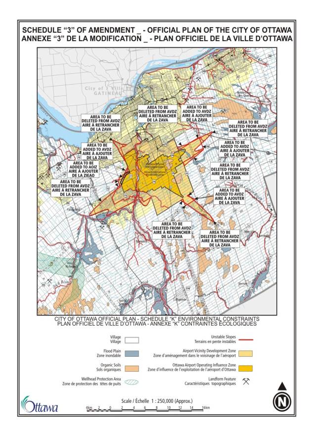
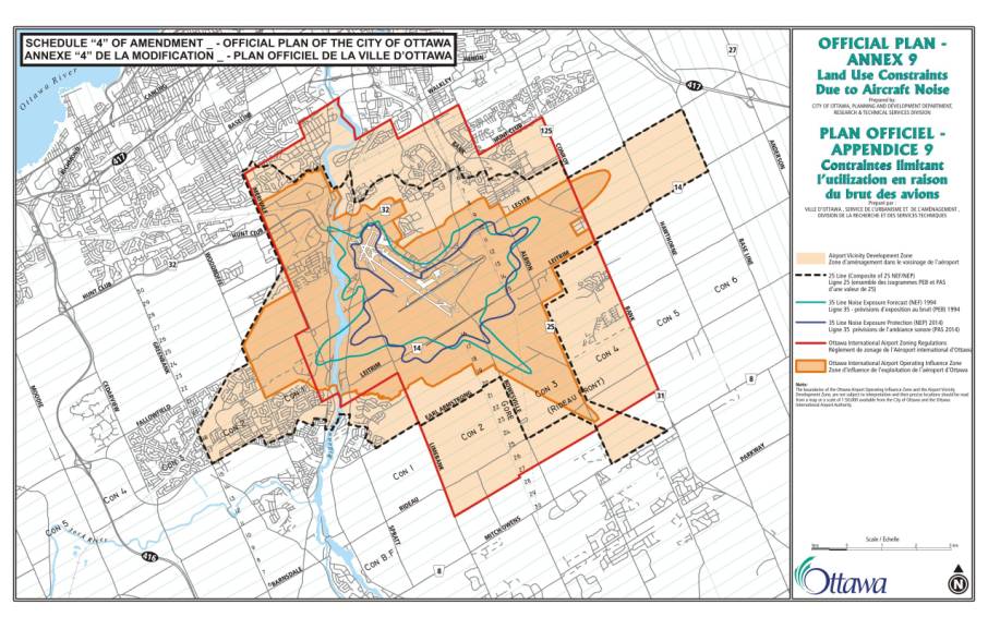
Section 4.8.7 Land-Use Constraints Due to Aircraft Noise
An appeal by the Ottawa
Macdonald-Cartier International Airport Authority (Appeal 80) triggered an
amendment to these policies and extensive editorial changes to make them more
clear. The Airport Authority is in agreement
with these proposed changes. Policy
changes introduced in the amendment are as follows:
Text in the preamble to
indicate that the boundaries of the Ottawa Airport Operating Influence Zone and
Airport Vicinity Development Zone are not subject to interpretation and should
be interpreted from a map at a scale of 1:50,000.
Policy permitting infilling
of residential uses if a minor variance is required, and provision for 4120A-L
Riverside Drive where infilling has been an issue in the past.
Introduction of a composite
of the 25 NEF and NEP contours developed by the former municipalities,
homebuilders, and the Ottawa Macdonald-Cartier International Airport
Authority. Use of the composite 25
NEF/NEP line reduces the area where noise studies are required for
noise-sensitive uses and reduces the boundary of the Airport Vicinity
Development Zone on Schedule K - Environmental Constraints.
The amendment also
introduces an annex that provides background information, such as NEF and NEP
contours, that is helpful in interpreting the policies. This annex is not part of the Plan, but is
provided for information purposes only.
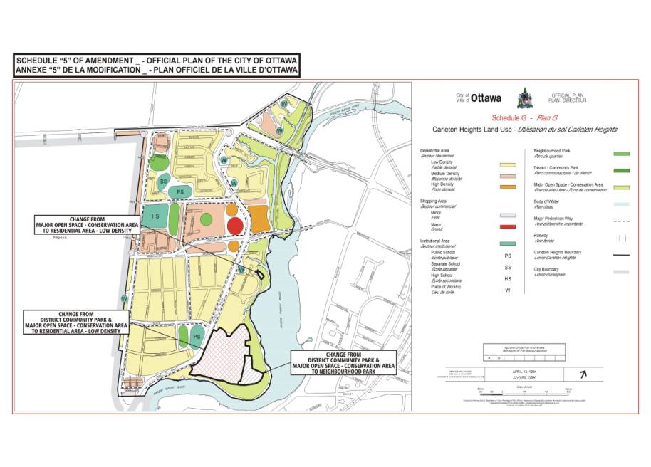
Schedule B - Urban Policy
Plan and Volume 2-A Secondary Plan for Carleton Heights
Schedules in Volume 1 and 2
of the Plan are amended to reflect the Ontario Municipal Board order on Moffat
Farm. The Ontario Municipal Board
ordered the approval of the draft plan of subdivision, draft conditions, the
official plan amendment, zoning by-law and final approval of the plan of
subdivision through order #1550 on November 18, 2003. Amendments to the
Regional Official Plan, old Ottawa Official Plan and the secondary plan for
Carleton Heights were approved by the Board.
An amendment to Volume 1 and 2 of the 2003 Official Plan is needed to
bring the Board decision into effect in the 2003 Ottawa Official Plan, and to
address an appeal of the 2003 Plan on behalf of the National Capital Commission
and DCR Pheonix (Appeal 82). The
amendment consists of changes to Volume 1 Schedule B, from Major Open Space to
General Urban Area, and Volume 2A on the Carleton Heights Land Use Schedule.
Schedule D - Primary Transit
Network
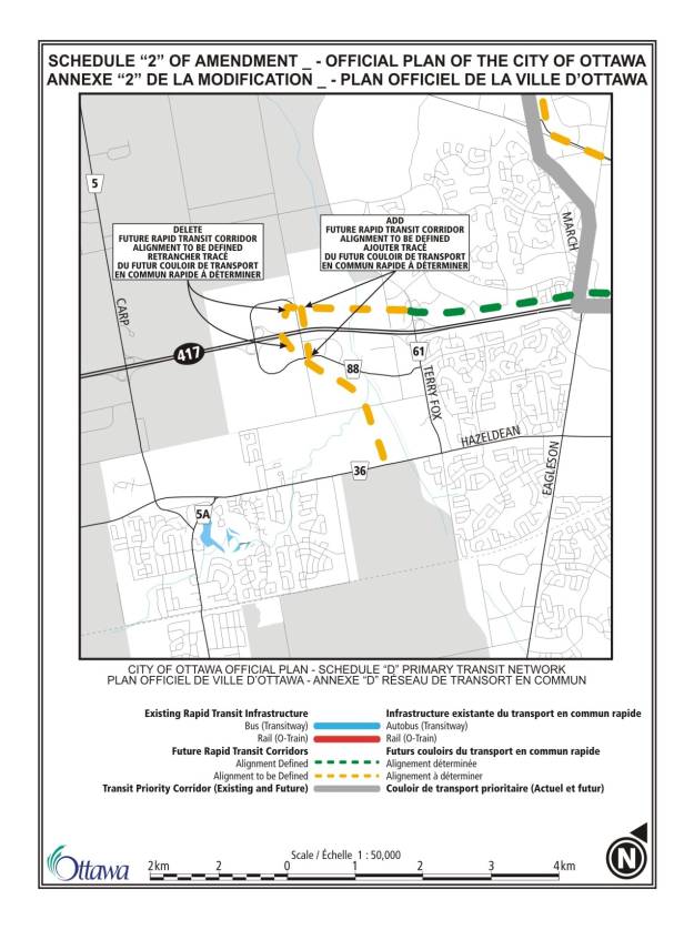
A segment of the Future
Rapid Transit Corridor (Alignment to be Defined) is proposed to be relocated
from west of Huntmar Drive to east of Huntmar Drive, north and south of Highway
417. The proposed change addresses an appeal on behalf of the Palladium Auto
Park (Appeal 73) and is consistent with the Kanata West Concept Plan approved
by Council.
Minor Policy Changes
The amendment attached as
Document 2 proposes minor changes initiated by staff in several policy
areas.
Section 2.4.3 Watershed and
Subwatershed Plans
Text changes are proposed to
introduce an annex showing where watershed and subwatershed studies are complete
or in progress. Changes in Sections
4.7.1 and 4.7.8 describe the role of watershed and subwatershed plans in the
integrated environmental review of development applications and in
environmental impact statements.
Section 2.4.5 Greenspaces
A new policy is added to
require an Environmental Impact Statement for development applications for land
in wetlands, woodlands and ravines in complexes of 0.8 ha or larger in the
urban area, until Council approves the Urban Natural Areas Environmental
Evaluation. This policy was included in
the January, 2003 draft of the Plan and the staff report on the March, 2003 plan indicated the policy had been
relocated within the Plan. However, it
was deleted through an editing error and is restored in this amendment.
Section 2.5.5 Cultural
Heritage Resources
The requirements for a
cultural heritage impact statement are extended to include new buildings in
heritage conservation districts.
Complementary changes are also proposed in Section 4.6.1 Heritage
Buildings and Areas.
Section 3.2.1 Significant
Wetlands South and East of the Canadian Shield
Section 3.2.2 Natural
Environment Area
Section 3.2.3 Urban Natural
Features
Section 3.2.4 Rural Natural
Features
Section 3.3.1 Major Open
Space
A new policy is added in
each of these sections to indicate that where these lands are privately owned,
public use is not permitted without the consent of the owner. The Official Plan
of the former Region of Ottawa-Carleton contained a similar policy.
Section 3.6.1 General Urban
Area
Section 3.6.5 Employment
Area and Enterprise Area
The amendment corrects the
designation(s) referred to in the policies, so that Employment Areas become the
locations for industrial uses and both Employment Areas and Enterprise Areas
accommodate over 2000 jobs, a target to be met if the land is to become a Mixed
Use Centre.
Further, the amendment
proposes to delete the requirement that apartments in Enterprise Areas be five
storeys in height. Discussions related to the retail appeals may result in
recommendations to revisit these sections.
Section 4.4.2.4 Small Water
and Wastewater Works
Minor wording changes
clarify the types of uses that can be accommodated by small water and
wastewater works.
Section 4.5 Housing
The Province of Ontario has
indicated it plans to amend the Tenant Protection Act, 1997 and is consulting
on a range of issues that includes demolitions and conversions. The current
Plan policy is difficult to implement, and therefore a new policy is proposed
to study the use of demolition control as a means of maintaining the affordable
housing supply. The demolition control by-law for land within the former City
of Ottawa will remain in effect until a new by-law is prepared.
Section 4.6.3 River
Corridors
A new policy is proposed to
set minimum lot sizes for development in the General Rural Area adjacent to the
Rideau River upstream from Roger Stevens Drive, to protect the cultural
heritage of the river. The 1997 Regional Official Plan had similar policies
that were not included in early drafts of the 2003 Ottawa Official Plan because
early drafts did not contemplate country lot subdivisions.
Section 5.3 Other
Implementation Policies
A new policy is proposed to
permit Council to consider the use of private agreements among landowners to share
the costs of infrastructure.
Schedule K - Environmental
Constraints
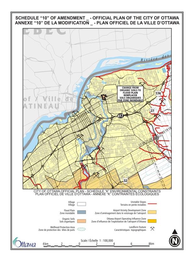
The boundary of the Ottawa
Airport Operating Influence Zone is proposed to be amended, to delete lands at
the intersection of Albion Road and Lester Road. The Ottawa Macdonald-Cartier International Airport Authority is
in agreement with the proposed change.
Volume 2A - Secondary Plans
for Longfields, Davidson Heights Communities, South Merivale Business Park
Secondary Plan - Area 1, 2, and 3
The amendment proposes to
delete the requirement that this residential area on private services be used
only for the existing single-detached houses and allows Council to consider new
lot creation subject to the policies in Volume 1 of the Plan. These policies
include policies on land use constraints due to aircraft noise and development
on private services in public service areas.
Editorial Changes and
Corrections
The amendment attached as
Document 3 proposes corrections and editorial changes with no policy
implications. The changes include the
addition of cross-references, correction to the numbering or location of
policies, and changes to maintain consistency among the policies. Minor wording changes are proposed,
consistent with the intent of the policy, for clarification. The amendment also corrects errors in the
schedules, including the boundary of the General Urban Area near Leitrim, and
adds the names of arterial roads.
The amendment updates the
text that indicates the Official Plan will be amended to reflect any changes
arising through Council's approval of the Transportation Master Plan (approved
after the Official Plan). It also
updates the schedules to reflect changes made in the Transportation Master
Plan, particularly with respect to Schedule D - Primary Transit Network. The transportation schedules are also
corrected and updated, to show where roads have been built and are no longer
"proposed".
Volume 2 of the Plan is also
corrected by inserting a new, correct schedule to the Central Area Plan,
restoring text and correcting cross-references in the Secondary Plan for
Preston-Champagne, and correcting the text and schedules for the site-specific
policies for the Kanata Town Centre.
Corrections and minor policy
changes to Annex 1 regarding road classifications and rights-of-way
This amendment attached as
Document 4 proposes minor policy changes to Tables 1 to 11 and 13 to 14 that
list the rights-of-way to be protected for defined segments of city freeways,
urban and rural arterials, major collectors, collectors and local roads. These changes include:
Adding new road segments and
rights-of-way from the official plans of the former local municipalities that
were omitted in error. Many of these
additions are local streets (Table 14) in older urban industrial/commercial
areas and the cores of a few rural villages.
Revising the description of
road segments subject to a specified right-of-way by correcting the names of
cross-roads that are used to define the segment.
Adding segments of certain
roads and identifying a new rights-of-way, typically where the classification
of a road has changed and the tables need revision.
Applying a uniform
right-of-way requirement to the entire length of roads running along the
boundaries of former local municipalities, where each municipality had applied
a different right-of-way protection.
The amendment also
introduces new text in to Section 1 of
the Annex, to refer to pedestrians, cyclists and transit users and to
acknowledge the greenspace and public space function of roadways.
The amendment also makes
clarifications and corrections to the annex, including:
Correcting the description
of road segments
Deleting descriptions of
road segments that are duplicates or that do not belong in the table
Revising the description of
road segments to improve consistency
Correcting the description
of road segments to correspond with how the roads are shown on Schedules E or H
Correcting typographical
errors, updating the names of streets that have been renamed, and other minor
editing changes
ENVIRONMENTAL IMPLICATIONS
The amendment attached as
Document 2 provides additional information about the role of watershed and
subwatershed plans in the planning process.
CONSULTATION
Consultation on the
amendments followed Council's Public Notification and Consultation Policy. A summary of the amendments was sent to all
organizations that had requested notification of amendments with city-wide application
and anyone who commented on the amendment received a notice of the public
meeting. In addition, the amendments
were advertised in March and August in daily newspapers and a summary was sent to all parties who had
appealed the 2003 Ottawa Official
Plan. Appellants were also
consulted on proposed changes to address all or part of their appeal.
Several parties commented on
the proposed change to the demolition control by-law. In all cases, the parties expressing concern (the Glebe, Action
Sandy Hill, Hintonburg and the University of Ottawa) are now subject to the
demolition control by-law of the former City of Ottawa and the proposed
amendments do not change the by-law now in effect. The community organizations were concerned about possible effects
of a demolition control by-law on the conversion of dwelling units; however,
such conversions for the most part do not entail demolition and would not be
subject to a demolition control by-law.
Staff will consult with community groups in preparing the new by-law.
The revised airport noise
policies were reviewed with the Ottawa-Carleton Home Builders' Association, the
Ottawa-Macdonald Cartier International Airport Authority, the National Capital
Commission and residents of 4120A-L Riverside Drive.
Parks Canada expressed its
support for the proposed policies regarding river corridors.
FINANCIAL
IMPLICATIONS
N/A
SUPPORTING DOCUMENTATION
Document 1 - Policy
Changes in response to appeals of the 2003 Ottawa Official Plan
Document 2 - Minor
Policy Changes
Document 3 - Editorial
Changes and Corrections
Document 4 - Corrections
and minor policy changes to Annex 1 regarding road classifications and
rights-of-way
Document
5 - Schedule 7 of Amendment -
Schedule "F" Central Area / Inner City Road Network
Document 6 - Schedule 9 of Amendment -
Schedule "I" Major Recreational Pathways & Scenic-Entry Routes
(Urban)
DISPOSITION
Planning and Growth
Management Department to provide Notice of Adoption of the Official Plan
Amendment by-laws.
POLICY CHANGES IN RESPONSE TO APPEALS
OF THE 2003
OTTAWA OFFICIAL PLAN Document 1
AMENDMENT NO. __TO THE OFFICIAL PLAN (2003)
OF THE CITY OF
OTTAWA
COMPONENTS
PART A – THE PREAMBLE
Purpose
Location
Basis
PART B – THE AMENDMENT
Introduction
Details
Implementation
COMPONENTS
PART A – THE PREAMBLE does not
constitute part of this Amendment.
PART B – THE AMENDMENT, consisting of
the following text and the attached maps designated as Schedules “1” to “5” to
Amendment No._, constitutes Amendment No. _to the Official Plan of the City of
Ottawa.
PART A - THE PREAMBLE
1. Purpose
The purpose of this Amendment is to make corrections and minor policy
changes to the 2003 Ottawa Official Plan.
2. Location
This Amendment
applies to all of the land within the boundaries of the City of Ottawa.
3. Basis
Ottawa
City Council adopted a new Official Plan in May, 2003. The Plan was approved with modifications by
the Minister of Municipal Affairs and Housing in November, 2003, and was
subsequently appealed by many parties.
Some of the appeals can be resolved in whole or in part through minor
policy changes that can be made to the Plan through this amendment. More specificially, the amendment proposes
the following changes:
·
Recognition that residential development in the
rural area will occur on country lot subdivisions
·
Site-specific policy on the Rideau-Carleton
Raceway
·
Clarification that residential uses are
permitted in Villages
·
Revision to policies on contaminated sites, to
allow building permits to be issued on a phased basis
·
Revisions to policies on land-use constraints
due to aircraft noise, including a reduction in the boundary of the Airport
Vicinity Development Zone
·
Schedule changes to reflect the Ontario
Municipal Board decision on Moffat Farm
·
Relocation of a segment of a Future Rapid
Transit Corridor (Alignment to be Defined) at Huntmar Drive
PART B - THE AMENDMENT
1. Introduction
All of this part of this document entitled Part B - The Amendment,
consisting of the following text and the attached maps designated as Schedules
“1” to “5” to Amendment No._, constitutes Amendment No. _to the Official Plan
of the City of Ottawa.
2. Details
The following
changes are hereby made to the Official Plan of the City of Ottawa:
1. Section
2.2.2 Village Boundaries is hereby amended by deleting the words, “While
individual homes will continue to be built throughout the rural area on
existing lots of record,” in the third sentence of the preamble and by adding
the words, “While homes will continue to be built in the rural area on new lots
created by severance or plan of subdivision in accordance with the policies of
this plan, and on existing lots of record,” in their place.
2. Section 3.6.7 Major Urban Facilities is
hereby amended by adding a new policy 4, as follows: “Notwithstanding the above policies requiring Major
Urban Facilities to locate in the urban area, in order to recognize the Rideau
Carleton Raceway and Slots facility, located on lands legally described as part
of the South Half of Lot 24, Concession 4, Rideau Front, Gloucester, being
Parts 5 and 11 on Plan 4R-15731; Parts of lots 23 and 24, Concession 4, Rideau
Front, Gloucester, being Part 2 on Plan 4R-15731; and consolidation of various
properties: Part of lot 24, Concession
4, Rideau Front, Gloucester, Being parts 3, 4, 6, and 7 on Plan 4R-15731, an exhibition grounds for the viewing of
horse racing, gaming premises as defined in the Gaming Control Act and
related uses are also permitted in addition to those uses permitted in the
General Rural Area designation, in this location.”
3. Section 3.7.1 Villages is hereby
amended by inserting the words “residential and” after the words “will include”
in policy 4.
4. Section 4.8.4 Contaminated Sites is hereby amended by
deleting policy 4 and inserting the following as a new policy 4, “The City will
require a Record of Site Condition (RSC) as a condition of approval for plans
of subdivision and condominium, site plan or severance applications, in
accordance with the Guideline of Use at Contaminated Sites in Ontario (1997),
confirming that the site is suitable or has been made suitable for the proposed
use, in the following circumstances:
a) the site is proposed for residential development or for a
use more sensitive to contamination or contaminants than the present or former
land use; and
b) available information indicates the site is or may be
contaminated, or is within 500 metres, or other influence area, of an active
landfill site.
Where an RSC
has been made a condition of City's approval, a building permit may be issued
in regard to a site on a phased basis to allow for site investigation and
remediation. An RSC must be completed to the satisfaction of the City and
acknowledged by the Ministry of Environment.”
5. Section 4.8.4 Contaminated Sites is hereby amended by
deleting policy 5 and inserting the following as a new policy 5, “For instances
where contamination extends onto a City right-of way and completion of a Record
of Site Condition is not possible, the City may issue a building permit on a
phased basis contingent on the execution and implementation of an Off-Site
Management Agreement or Remedial Action Plan to remediate the right-of-way and
development site, to the satisfaction of the City.”
6. Section
4.8.7 Land-Use Constraints Due to Aircraft Noise is hereby amended by deleting
all of section 4.8.7 and inserting the following:
“4.8.7 Land-Use
Constraints Due to Aircraft Noise
The Ottawa
Macdonald-Cartier International Airport as well as the airports at Carp and
Rockcliffe support the economic development of the National Capital Region and
therefore warrant protection from incompatible development. At the same time, new communities must be
planned and then built according to appropriate building standards so that
noise-sensitive land uses are protected from the adverse effects of aircraft
noise. Noise-sensitive land uses are housing, institutional uses, public
facilities and outdoor recreation spaces.
Specific examples include, but are not limited to, campgrounds,
hospitals, places of worship, schools, day care facilities, long-term care
facilities, libraries, auditoriums and community centres. Hotels and motels are also noise-sensitive
land uses, but they are treated differently from other such uses because they
benefit from convenient access to the airport and the impact of noise on people
is reduced by the short duration of most visits.
The types of
land uses that are compatible with noise levels in the vicinity of airports are
determined through reference to federal guidelines based on the Noise Exposure
Forecast (NEF) and Noise Exposure Projection (NEP) system. This system uses
noise contours to graphically display the expected level of annoyance within
specific areas around airports. These
noise contours have been used in this Plan to define the boundaries of areas
that are affected by the airport and to set policies for these areas. These areas include Greenbelt lands and urban
and rural areas; the policies regarding airport noise are to be considered in
addition to policies for these areas elsewhere in this Plan.
The boundary
of the Ottawa Airport Operating Influence Zone is based on the 30 NEF and NEP
contours. Within this area, noise-sensitive development is generally not
permitted, although infill and redevelopment may occur in specific areas within
the zone in keeping with the policies below.
The boundary of the Ottawa Airport Operating Influence Zone has been
drawn to coincide with physical features such as roads, creeks, rail lines, and
lot lines where possible. The boundary of the Ottawa Airport Operating
Influence Zone, shown on Schedule K, is not subject to interpretation and its
precise location should be read from a map at a scale of 1:50 000 available
from the City of Ottawa and the Ottawa-Macdonald Cartier International Airport
Authority.
The boundary
of the Airport Vicinity Development Zone is based on the boundary set for the
Ottawa International Airport Zoning regulations and the composite of the 25 NEF
and NEP contours. The composite of the
NEF and NEP contours has also been drawn to coincide with physical features
such as roads, creeks, rail lines, and lot lines where possible. Like the boundary of the Ottawa Airport
Operating Influence Zone, the boundary of the Airport Vicinity Development Zone
is shown on Schedule K and is not subject to interpretation.
Annex 9 shows
the boundaries of the composite 25 NEF and NEP contours and the Ottawa
International Airport Zoning regulations, and illustrates how the two combine
to make up the boundary of the Airport Vicinity Development Zone. Noise-sensitive uses are permitted between
the 25 NEF/NEP composite and the boundary of the Ottawa Airport Operating
Influence Zone, provided the noise is attenuated. Noise-sensitive uses are permitted outside the boundary of the 25
NEF/NEP composite without attenuation, although the Ottawa International
Airport Zoning regulations may apply.
The Ottawa International Airport Zoning regulations address the
height of buildings and vegetation near the airport and apply to most lands
within the Ottawa Airport Operating Influence Zone and the Airport Vicinity
Development Zone.
Policies
Aircraft Noise – Ottawa Macdonald-Cartier
International Airport
1. Land impacted by the operation
of the airport is identified on Schedule K as the Ottawa Airport Operating
Influence Zone and the Airport Vicinity Development Zone. These zones have been identified in order to
protect the economic potential of the city’s airports as well as protect
residents from the adverse impacts of unacceptable levels of noise. Review of development applications in these
zones will be guided by the Transport Canada manual TP1247E - Land Use in
the Vicinity of Airports and the Ministry of Environment Noise
Assessment Criteria in Land Use Planning LU-131, as amended periodically.
2. A detailed noise control study
may be required for any development proposal at or above the 25 NEF/ NEP
contour. A detailed noise control study
includes, but is not limited to:
a) Consideration
of all airport noise sources, including noise produced by aircraft run-ups and
taxiing, the reverse thrust noise produced by landing aircraft, and helicopter
noise;
b) Consideration
of noise from sources other than the airport, including roads, rail lines and
industry;
c) Details of the assessment methods, results, and recommendations
for noise control measures, and provisions for how the measures will be secured
through the conditions of approval of plans of
subdivision and condominium, site plan or severance applications.
3. Within the Ottawa Airport Operating Influence
Zone, designated on Schedule K, no development of residential and other
noise-sensitive land uses will be permitted above the 35 NEF and 35 NEP contour
lines, whichever is more restrictive.
4. Within the Ottawa Airport Operating Influence
Zone, no development of residential and other noise-sensitive land uses will be
permitted between the boundary of the Ottawa Airport Operating Influence Zone
and the 35 NEF and 35 NEP contour lines (whichever is more restrictive),
except:
a) The redevelopment of existing residential and other
noise-sensitive land use;
b) Infilling of new residential uses;
c) Hotels and motels.
5. Further to policy 4,
redevelopment of existing residential and other noise-sensitive land uses and
infilling of new residential uses will only be permitted where the development:
a) Does not
require the approval of a plan of subdivision, or amendment to the zoning
by-law or amendment to this Plan; and
b) Is on a
new lot created by a severance where the severance is permitted in the zoning
by-law existing on May 14, 2003 and is in accordance with all the provisions of
the Plan; or
c) Is on a
lot existing and fronting on a public road that is maintained year-round,
provided that the lot was created under the Planning
Act by May 14, 2003, and
the use is permitted in the zoning by-law and is in accordance with all the
provisions of this Plan. This policy is
not to be interpreted so as to require a change in the provisions of the zoning
by-law for 4120A-L Riverside Drive in effect on May 14, 2003.
6. Further to policy 4, a detailed noise control study will be required
for any redevelopment of existing residential and other noise-sensitive land
uses and infilling of new residential uses. Development of hotels or motels
will only be permitted where it can be demonstrated that such land uses are
highly desirable in terms of the location and the attributes of the site.
7. Within the Airport Vicinity
Development Zone, noise-sensitive uses will be permitted between the 25 NEF/NEP
composite and the boundary of the Ottawa Airport Operating Influence Zone,
subject to the policies elsewhere in this Plan, provided appropriate noise
attenuation measures are in place.
Applications for noise-sensitive uses require either:
a) A detailed
noise control study that includes recommendations for noise control measures to
meet provincial criteria, as outlined in LU-131 Noise Assessment Criteria in
Land Use Planning; or,
b) Application
of the Prescribed Measures to Address Airport Noise prepared in July,
1998 by area municipalities, homebuilders and the Ottawa Macdonald-Cartier
International Airport Authority. These
measures apply only to typically-built residential tract housing.
8. Proposed development will
comply with the Ottawa International Airport Zoning regulations, enacted under
the Aeronautics Act, regarding the
location and height limits of objects in the vicinity of the airport. The
zoning regulations can be examined at the Land Registry Office.
9. Proposed developments will
also comply with Transport Canada’s manual TP
1247 – Land-Use in the Vicinity of Airports, including:
a) protection
of navigational aids and telecommunications systems at the airport through
attention to building height,
orientation and use of metallic substances that could interfere with these
systems;
b) restrictions on land uses that could attract
birds and wildlife and pose a hazard to aircraft operations.
Aircraft Noise – Carp and Rockcliffe Airports
1. No noise-sensitive uses will be permitted
above the 30 NEF and 30 NEP contour lines.
2. Development applications that
propose noise-sensitive land uses between the 25 NEF and 25 NEP and the 30 NEF
and 30 NEP contours require a detailed noise control study. ”
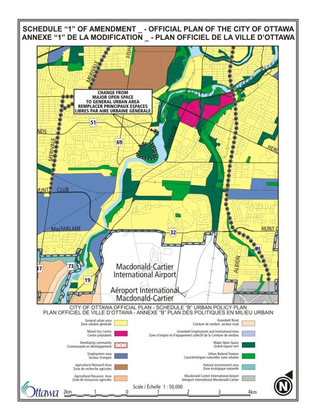
7. Schedule B – Urban Policy Plan is
hereby amended by changing the designation of a portion of the plateau
lands at 1709 Prince of Wales Drive, and a portion of a 3.6 ha (9 acre) parcel
to the north, from Major Open Space to General Urban Area, as shown on Schedule
1 attached.
8. Schedule D – Primary Transit Network is hereby amended by
changing the location of the segment of the Future Rapid Transit Corridor (Alignment
to be Defined) from west of Huntmar Drive to east of Huntmar Drive north and
south of Highway 417 as shown on Schedule 2 attached.
9. Schedule K – Environmental Constraints – is hereby amended
by changing the boundary of the Airport Vicinity Development Zone and the
Airport Operating Influence Zone, as shown in Schedule 3 attached.
10. The Annexes of the Ottawa Official Plan
are hereby amended by inserting a new Annex 9 Land-Use Constraints Due to
Airport Noise after Annex 8, as shown in Schedule 4 attached. The Plan is further amended by renumbering
the annexes in the Plan and revising references in the text as required.
Volume 2A – Secondary Plans
11. The
Secondary Plan for Carleton Heights is hereby amended by the following changes
on Schedule G – Carleton Heights Land Use, as shown on Schedule 5 attached:
a) A portion of the plateau
lands at 1709 Prince of Wales Drive is changed from District/Community Park and
Major Open Space – Conservation Area, to Residential Area – Low Density,
b) A portion of the plateau
lands at 1709 Prince of Wales Drive is changed from District/Community Park and
Major Open Space – Conservation Area, to Neighbourhood Park, and
c) A portion of the 3.6-ha
(9 acre) parcel to the north is changed from Major Open Space – Conservation
Area to Residential Area – Low Density
3. Implementation
The implementation of this Amendment to the Official Plan shall be
in accordance with the policies of the 2003 Official Plan of the City of
Ottawa.
MINOR POLICY
CHANGES Document
2
AMENDMENT NO. __TO THE OFFICIAL PLAN (2003)
OF THE CITY OF
OTTAWA
COMPONENTS
PART A – THE PREAMBLE
Purpose
Location
Basis
PART B – THE AMENDMENT
Introduction
Details
Implementation
COMPONENTS
PART A – THE PREAMBLE does not
constitute part of this Amendment.
PART B – THE AMENDMENT, consisting of
the following text and the attached maps designated as Schedules “1” and “2” to
Amendment No._, constitutes Amendment No. _ to the Official Plan of the City of
Ottawa.
PART A - THE PREAMBLE
1. Purpose
The
purpose of this Amendment is to make minor policy changes, corrections and
clarifications to the 2003 Ottawa Official Plan.
2. Location
This Amendment applies to
all of the land within the boundaries of the City of Ottawa.
3. Basis
Following
adoption of the Ottawa Official Plan in May, 2003, several areas were
identified in the Plan where additional policies would strengthen the intent of
the Plan or correct errors or omissions.
This amendment proposes the following changes:
·
A new annex showing watershed and subwatershed
planning areas and text references to the role of these studies
·
Correction of an editing error, to restore a
policy requiring an Environmental Impact statement for wetlands, woodlands, and
ravines in the urban area
·
An additional requirement for a cultural
heritage impact statement, for new buildings in heritage conservation districts
·
A policy in various greenspace designations,
indicating that where these lands are privately owned, public use is not
permitted without the consent of the owner.
Plans of the former municipalities contained this policy.
·
Correction of editing errors in the policies
affecting Employment Areas and Enterprise Areas
·
Minor wording changes to policies on small
water and wastewater works
·
Revision of the policy on demolition control,
to indicate the City will enact a demolition control by-law.
·
A policy on minimum lot sizes adjacent to the
Rideau River upstream from Roger Stevens Drive. Plans of the former municipalities contained a similar policy.
·
A new policy to permit Council to consider the
use of private agreements among landowners to cost-share infrastructure
·
A revision to the boundary of the Ottawa
Airport Operating Influence Zone
·
Revision to the policies for a residential area
on private services described in the secondary plans for Longfields, Davidson
Heights Communities, South Merivale Business Park Secondary Plan – Area 1, 2,
and 3
PART B - THE AMENDMENT
1. Introduction
All of this part of this
document entitled Part B - The Amendment, consisting of the following text and
the attached maps designated as Schedules “1” and “2” to Amendment No._,
constitutes Amendment No. _ to the Official Plan of the City of Ottawa.
2. Details
The following changes are hereby made to
the Official Plan of the City of Ottawa:
1. Section 2.4.3 Watershed
and Subwatershed Plans is hereby amended by adding a new sentence, “Areas
where watershed or subwatershed studies have been approved are shown in Annex
2.” at the end of policy 4.
2. Section 2.4.5 Greenspaces is hereby
amended by adding a new policy 7 after policy 6 as follows, “Until such time as
the Urban Natural Areas Environmental Evaluation Study is approved by Council,
an Environmental Impact Statement, as described in Section 4.7, is required for
subdivision, zoning, and site plan applications for land within all wetlands,
woodlands, and ravines in complexes of 0.8 hectares or larger in the urban
area.” Subsequent policies are renumbered
accordingly.
3. Section 2.5.5. Cultural Heritage
Resources is hereby amended by inserting the words, “or to construct a new
building within a heritage conservation district” in policy 2, after the words,
“or within designated Heritage Conservation Districts”.
4. Section 3.2.1 Significant Wetlands
South and East of the Canadian Shield is hereby amended by inserting a new
policy 10, as follows, “Where Significant Wetlands South and East of the
Canadian Shield are privately owned, public use and access to these lands for
any purpose is not permitted without the consent of the owner.”
5. Section 3.2.2 Natural Environment Areas
is hereby amended by inserting a new policy 6, as follows, “Where Natural
Environment Areas are privately owned, public use and access to these lands for
any purpose is not permitted without the consent of the owner.” Subsequent policies are renumbered
accordingly.
6. Section 3.2.3 Urban Natural Features is
hereby amended by inserting a new policy 6, as follows, “Where Urban Natural
Features are privately owned, public use and access to these lands for any
purpose is not permitted without the consent of the owner.”
7. Section 3.2.4 Rural Natural Features is
hereby amended by inserting a new policy 6, as follows, “Where Rural Natural
Features are privately owned, public use and access to these lands for any
purpose is not permitted without the consent of the owner.”
8. Section 3.3.1 Major Open Space is
hereby amended by inserting a new policy 7, as follows, “Where land designated
Major Open Space is privately owned, public use and access to these lands for
any purpose is not permitted without the consent of the owner.”
9. Section 3.6.1 General Urban Area is
hereby amended by deleting the words “Enterprise Area” in policy 9 after the
words “an appropriately zoned area within an” and inserting the words
“Employment Area”.
10. Section 3.6.5 Employment Area and
Enterprise Area is hereby amended by deleting the words “An Enterprise Area”
from the beginning of the second sentence of the preamble and inserting the
words “Employment Areas and Enterprise Areas”.
11. Section 3.6.5 Employment Area and
Enterprise Area is hereby amended by deleting the words “provided for the
Employment Area, and” from policy 7c) after the words “the employment targets”
and inserting the words “for the area” after the word “established”, so that
the policy as amended is as follows, “As a minimum, the employment targets
established for the area in the applicable zoning at the time of adoption of
this Plan, will be achieved.”
12. Section 3.6.5 Employment Area and
Enterprise Area is hereby amended by deleting the words “where apartments are
at least five storeys in height unless otherwise subject to approval by City
Council through the adoption of a community design plan;” in policy 8b).
13. Section 4.4.2.4 Small Water and
Wastewater Works is hereby amended by deleting the words “seniors’ homes” in
policy 2 after the words “schools and” and inserting the words “retirement
homes”.
14. Section 4.4.2.4 Small Water and
Wastewater Works is hereby amended by inserting the words “or complex of
buildings that comprise an institution,” in policy 1 after the words “single
building”.
15. Section 4.5 Housing is hereby amended by
deleting policy 5 and replacing it with a new policy 5, as follows “The city
will enact a demolition control by-law to apply throughout the urban area as a
means of maintaining the supply of affordable housing. Exceptions to the By-law will be considered
provided other objectives of the Official Plan are met.”
16. Section 4.6.1 Heritage Buildings and
Areas is hereby amended by deleting the word “or” after the word “demolished”
in policy 1 and inserting the words “or where a new building is proposed within
a heritage conservation district,”.
17. Section 4.6.1 Heritage Buildings and Areas
is hereby amended by adding the words “or heritage conservation district” in
policy 1a) after the words “heritage resource”.
18. Section 4.6.3 River Corridors is hereby
amended by inserting a new policy 1e) as follows “Requiring zoning by-laws for
development outside Villages in the General Rural Area adjacent to the Rideau
River and Rideau Canal upstream from Roger Stevens Drive, to provide for a
minimum lot size of 5 hectares and a minimum of 200 metres of waterfront unless
an alternate design has the same or less impact, as assessed by a cultural
heritage impact statement.”
19. Section 4.7.1 Integrated Environmental
Review to Assess Development Applications is hereby amended by deleting the
second sentence from the preamble and inserting the following sentences “The
integrated environmental review considers as a whole the significant findings
from individual support studies (ie, tree tree preservation and
protection plans, environmental impact statements, stormwater site management
plans, Phase 1 Environmental Site Assessments). It also ensures that development proceeds in keeping with the
analysis and recommendations of any watershed and subwatershed studies and
federal or provincial environmental assessments documents, where
applicable. The integrated
environmental review ensures that development design complies with the
environmental policies contained in Section 4, and that the principles of
design with nature have been applied.”
20. Section
4.7.8 Environmental Impact Statement is hereby amended by inserting the word
“and subwatershed” in policy 1a) after the words “such as watershed”. Policy 1 a) is further amended by deleting
the second sentence and inserting the following, “Generally completed by the municipality
or other public agency, these studies may provide direction to more detailed
Environmental Impact Statements by identifying environmental features and
functions and recommending land management practices;”
21. Section 5.3 Other Implementation Policies
is hereby amended by inserting a new policy 4, as follows, “Subject to City
Council approval, the City may consider the use of private agreements among
landowners to cost-share roads, piped services, and other infrastructure
identified in Community Design Plans or comprehensive servicing studies
approved by Council. Such agreements
are initiated by landowners within a defined area and provide for the fair
sharing of infrastructure costs among the benefiting parties. Where such agreements are in place, the City
will require evidence of paid-up membership in the agreement as a condition of
approval for plans of subdivision and condominium, site plan or severance
applications.”
22. Schedule K – Environmental Constraints – is hereby amended by
changing the boundary of the Ottawa Airport Operating Influence Zone to
correspond with the intersection of Albion Road and Lester Road, as shown on
Schedule 1 attached.
23. The Annexes of the Ottawa Official Plan
are hereby amended by inserting a new Annex 2 Watershed and Subwatershed Plans
after Annex 1, as shown in Schedule 2 attached. The Plan is further amended by renumbering the annexes in the
Plan and revising references in the text as required.
Volume 2A – Secondary Plans
3. Implementation
The implementation of this
Amendment to the Official Plan shall be in accordance with the policies of the
2003 Official Plan of the City of Ottawa.
EDITORIAL CHANGES
AND CORRECTIONS Document
3
AMENDMENT NO. __TO THE OFFICIAL PLAN (2003)
OF THE CITY OF
OTTAWA
COMPONENTS
PART A – THE PREAMBLE
Purpose
Location
Basis
PART B – THE AMENDMENT
Introduction
Details
Implementation
COMPONENTS
PART A – THE PREAMBLE does not
constitute part of this Amendment.
PART B – THE AMENDMENT, consisting of
the following text and the attached maps designated as Schedules “1” to “12” to
Amendment No._, constitutes Amendment No. __ to the Official Plan of the City
of Ottawa.
PART A - THE PREAMBLE
1. Purpose
The purpose of this Amendment is to make corrections and
clarifications to the 2003 Ottawa Official Plan.
2. Location
This Amendment applies to all of the land
within the boundaries of the City of Ottawa.
3. Basis
Ottawa
City Council adopted a new Official Plan in May, 2003. Since that time, minor errors in the text
and schedules of the Plan have been identified as well as areas where updating
and other editorial changes are required.
This amendment proposes the following changes:
·
Updating of text that indicates the Plan will
be amended after the Transportation Master Plan is approved by Council
·
Addition of cross-references
·
Renumbering or relocation of policies
·
Minor wording changes consistent with the
intent of the policy
·
Addition of road names to schedules, correction
of errors, and updating the status of roads from “proposed” to “existing”
·
Changes to road and transit designations to
reflect provisions of the Transportation Master Plan
·
Correction of schedules or text in Volume 2
regarding the Central Area, Preston-Champagne, and the Kanata Town Centre
PART B - THE AMENDMENT
1. Introduction
All of this part of this
document entitled Part B - The Amendment, consisting of the following text and
the attached maps designated as Schedules “1” to “12” to Amendment No._,
constitutes Amendment No. _to the Official Plan of the City of Ottawa.
2. Details
The following changes are hereby made to
the Official Plan of the City of Ottawa:
1. Section 2.3.1 Transportation is hereby
amended by deleting the words, “The City is preparing a” from the first
sentence of the ninth paragraph and inserting the words, “City Council has
adopted a” in their place. The second
sentence of this paragraph is further amended by deleting the word, “will”
before the word, “guide”. The third
sentence is further amended by deleting the words, “will identify” and
inserting the word “identifies” in their place.
2. Section 2.3.1
Transportation is hereby amended by deleting the words, “As an interim policy,”
from the first sentence of the tenth paragraph and inserting “In keeping with
the Transportation Master Plan,” in their place.
3. Section 2.3.1 Transportation is hereby
amended by deleting the words, “When the new Transportation Master Plan is
approved in 2003, this Plan will be amended as required to reflect any needed
policy or schedule information.” from policy 1.
4. Section 2.3.1 Other Rights-of-Way
Protection is hereby amended by adding the words, “or, as outlined in Section
2.4.5, public access to the shore of a water body.” at the end of policy 39.
5. Section 2.5.5. Cultural Heritage Resources is hereby amended
by deleting the words, “a Heritage Advisory Committee” from policy 4 and
inserting the words “an Arts, Culture and Heritage Advisory Committee” in their
place.
6. Section 3.1
Generally Permitted Uses is hereby amended by deleting policy 11d) and
inserting a new policy 12 as follows, “When reviewing development applications
for new communications facilities, the City will ensure that ground level
compounds and equipment facilities are attractively designed and screened from
public view.” Subsequent policies are
renumbered accordingly.
7. Section 3.2.2 Natural Environment Area
is hereby amended by inserting the words, “may be” in the first line of the fourth
paragraph of the preamble, after the words, “private individuals and”.
8. Section 3.2.4 Rural Natural Features is
hereby amended by deleting policy 2a as follows, “Involving the creation of two
or more lots by severance or subdivision” and inserting a new policy 2a as
follows, “Involving the creation of more than one lot;”
9. Section 3.2.4 Rural Natural Features is
hereby amended by deleting policy 4, as follows, “In order to preserve what is
irreplaceable, where a Major Open Space abuts a river corridor as defined in
Section 4.6.3, any activities or uses in policy 3 (above) must be ones that
require a waterfront location.”
10. Section 3.3.1 Major Open Space is hereby
amended by inserting a new policy 4 as follows, “In order to preserve what is
irreplaceable, where a Major Open Space abuts a river corridor as defined in
Section 4.6.3, any activities or uses in policy 3 (above) must be ones that
require a waterfront location.”
Subsequent policies are renumbered accordingly.
11. Section 3.6.1 Provisions
for Retail is hereby amended by deleting the words “defined in” and inserting
the words “described in” in policy 4, after the words “will be considered,”.
12. Section 3.7.1 Villages is hereby amended
by inserting the words “and subject to the policies of Section 4.4 on water and
wastewater servicing” after the words “available servicing methods”.
13. Section 3.7.3 Agricultural Resources is
hereby amended by adding the words “full-time” after the words “A second
dwelling for” in policy 3.
14. Section 3.7.3 Agricultural Resources –
Possible Uses at Highways 416 and 417 Interchanges is hereby amended by
inserting the words “ and, where necessary, severed from the parent parcel.” in
policy 8b) after the words “area to be rezoned”.
15. Section 3.7.3 Agricultural Resources –
Farm-Related Severances is hereby amended by deleting the word “deed” in the
last sentence of policy 9 and inserting the word “title”.
16. Section 3.7.4 Mineral
Resources is hereby amended by inserting the words “as shown on Schedule A” in
policy 16 after the words “City of Kanata”.
17. Section 3.10.1 Ottawa Macdonald-Cartier
International Airport is hereby amended by deleting the words “Section 3.5” in
policy 1b) and inserting the words “Section 3.6.5”.
18. Section 4.2 Adjacent to Land-Use
Designations is hereby amended by deleting the number “3.2.3” in the third ROW
of the table and inserting the number “2.4.5”.
The third ROW is further amended by deleting the word “field” and
inserting the words “and ravines” after the word “forests”.
19. Section 4.2 Adjacent to Land-Use
Designations is hereby amended by deleting the words “Adjacent to” in the
fourth ROW and inserting the words “Within 30 m of”.
20. Section 4.4.2 Private Water and
Wastewater Servicing is hereby amended by deleting the words “Applications for
subdivision” in policy 2 and inserting the words “As per policy 6 of Section
3.7.2 on the General Rural Area, country lot subdivisions in the General Rural
Area are limited to a maximum size of 40 lots.
Applications for subdivisions in Villages”.
21. Amend Section 4.6.1 Heritage Buildings
and Areas by deleting the words “cash-in-lieu of parking,” in policy 7 after
the words “demolition control”.
22. Section 4.6.3 River Corridors is hereby
amended by inserting the sentence “Public access to shorelines will be pursued
through various means, as described in Section 2.4.5.” at the beginning of
policy 2, before the sentence beginning “For plans of subdivision”.
23. Section 4.7.3 Erosion Prevention and
Protection of Surface Water is hereby amended by deleting the words “policies 2
through 5 of this subsection” in policy 1d) after the words “as described in”
and inserting the words “policy 2.”
24. Section 4.7.3 Erosion
Prevention and Protection of Surface Water is hereby amended by renumbering
policy 1e) to become a new policy 2.
The existing policy 2 and existing policy 3 are inserted at the end of
the new policy 2, so that the new policy 2 is as follows, “No
development or site alteration is
permitted within a minimum setback of 30 metres from the normal high water mark of
rivers, lakes and streams, as determined in consultation with the appropriate
Conservation Authority, or, where there is a defined bank, 15 metres from the top
of the bank, whichever is greater. Development is defined as the creation of a
new lot or the construction of buildings and structures requiring approval
under the Planning Act. Development does not include activities
that create or maintain infrastructure within
the requirements of the environmental assessment process or works subject to
the Drainage Act. Site alteration is
defined as activities, such as fill, grading and excavation, that would change
the landform and natural vegetative characteristics of a site.” The subsequent policies are renumbered as
required.
25. Section
4.7 Protection of Health and Safety is hereby amended by deleting the word
“feasibility” from the ninth ROW of the table, after the words “noise control”.
Schedules
26. Schedule A – Rural Policy Plan is hereby
amended by adding a symbol to designate the location of
a silica sandstone deposit affecting development on Lot 20, Concession III in
former Kanata and lands within 450 m of the lot, as shown on Schedule 1,
attached.
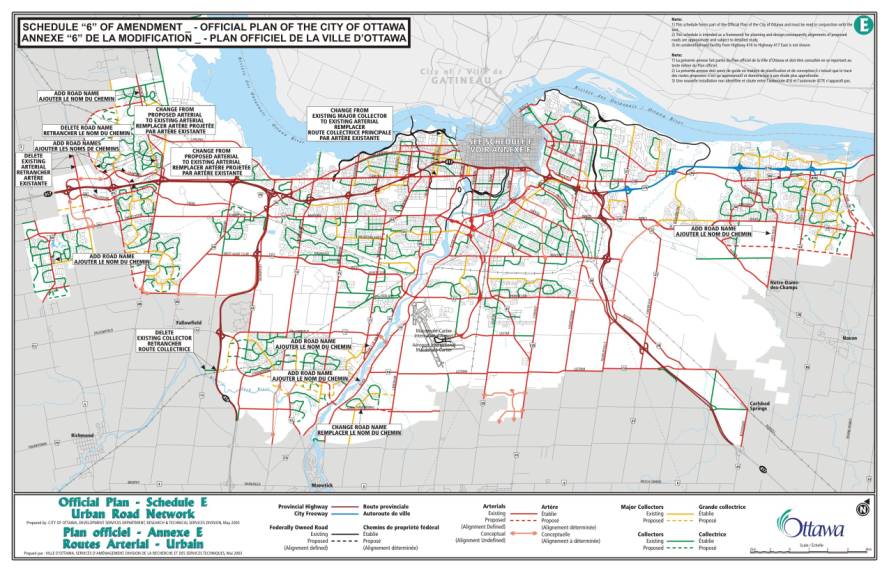
27. Schedule B – Urban Policy Plan is hereby amended by:
a) changing the location of the street
name “March” and by adding the arterial street names, “Palladium”, “Campeau”,
“Mer Bleue”, “River”, and “Prince of Wales”, as shown on Schedule 2, attached.
b) adjusting the boundary of the General
Urban Area and Developing Community designation in Leitrim, to correspond with
the wetland boundary on Schedule A, as shown on Schedule 3, attached.
28. Schedule C – Primary Urban Cycling
Transportation Network is hereby amended by adding the arterial street
names, “Main” (in Stittsville),
“Palladium”, “Campeau”, “Mer Bleue”, “River”, and “Prince of Wales”, as shown
on Schedule 4, attached.
29. Schedule D – Primary Transit Network is
hereby amended by:
a) changing the location of
the Future Rapid Transit Corridor (Alignment to be Defined) to a location east
of March Road, as shown on Schedule 5, attached;
b) deleting the Future
Rapid Transit Corridor (Alignment to be Defined) south of Strandherd Drive and
south of Leitrim beyond the urban boundary, as shown on Schedule 5, attached;
c) deleting the Transit
Priority Corridor (Existing and Future) east of Eagleson on Highway 417, and
changing the Future Rapid Transit Corridor (Alignment Defined) to Existing
Rapid Transit Infrastructure - Bus
(Transitway), as shown on Schedule 5, attached;
d) deleting two segments of
the Transit Priority Corridor (Existing and Future) on Carling Avenue and
Bayshore Drive, as shown on Schedule 5, attached;
e) deleting the Transit
Priority Corridor (Existing and Future) across the Ottawa River, as shown on
Schedule 5, attached;
f) changing a segment of
the Transit Priority Corridor east of Blair Road to Existing Rapid Transit
Infrastructure – Bus (Transitway), as shown on Schedule 5, attached;
g) changing the location of the street name “March” and by
adding the arterial street names, “Main” (in Stittsville), “Palladium”,
“Campeau”, “Mer Bleue”, “River”, and “Prince of Wales”, as shown on Schedule 5,
attached.
31. Schedule G – Rural Road Network is hereby amended by:
a) adding as a “Collector – Existing” the
segment of Spratt Road north of Rideau Road to the urban area limit as
identified in Schedule “7”, attached;
b) adding as a “Collector – Existing” the
segment of 4th Line Road from Forest Road to Belmeade Road as
identified in Schedule “7”, attached.
32. Schedule I – Major Recreational Pathways
& Scenic-Entry Route (Urban) is hereby amended by:
a) adding as a new Scenic-Entry Route the
segment of the future roadway known as the Strandherd/Earl Armstrong Road
connection, as identified in Schedule “8”, attached;
b) adding the words “Existing and Proposed
/ Existants et proposés” in the legend block at the bottom directly above the
words “Major Recreational Pathways – Principaux sentier récréatifs” and that
the legend description of “Other Open Space” be moved in its entirety from the
legend to an inside corner of the map portion of the Schedule, as shown on
Schedule 8, attached;
c) changing the location of the street
name “March”and by adding the arterial street names: “Main” (in Stittsville), “Palladium”, “Campeau”, “Mer Bleue”,
“River”, and “Prince of Wales”, as shown on Schedule 8, attached.
33. Schedule J – Major Recreational Pathways
& Scenic-Entry Route (Rural) is hereby amended by adding the words
“Existing and Proposed / Existants et proposés” in the legend block at the
bottom directly above the words “Major Recreational Pathways – Principaux
sentier récréatifs”, as shown on Schedule 9, attached
34. Schedule K – Environmental Constraints – is hereby amended by
changing the designation of Organic Soils in Vanier to Flood Plain, as shown on
Schedule 10, attached.
Volume 2A – Secondary Plans
36. The Secondary Plan for Preston-Champagne
is hereby amended by adding the following text and the margin note “Southeast
Quadrant” in policy 6.2 after the section “Southwest Quadrant”:
“In
the Southeast Quadrant (south of the Queensway and east of the CPR corridor) medium
and high profile employment uses will continue to develop along Carling Avenue
and immediately south of the Queensway and east of Preston Street. A transition to low and medium profile
residential uses and neighbourhood commercial uses on Preston street will occur
from these higher profile employment uses.
In the residential areas, new, incompatible non-residential uses will be
prohibited to encourage protection of the existing housing stock..”
37. The Secondary Plan for
Preston-Champagne is hereby amended by the following:
a) Delete the first reference to the words
“Section 3.6.2” in policy 6.4a) and inserting the words “Section 3.6.1 or 3.6.2
as appropriate.”
b) Delete the words “Section 3.6.2” in the
second sentence of policy 6.4.f) and insert “Section 3.6.1”.
c) Delete the words “and 3.6.2” at the end
of the second sentence in policy 6.4g) and insert the words “3.6.1, 3.6.2, and
3.6.3 as appropriate”.
d) Delete the words “and 3.6.2” from the
end of policy 6.4o) and insert the words “,3.6.2 and 3.6.3”.
Volume 2B – Site-Specific Policies
“5.7.3.1 GOAL
Create a vibrant, attractive
core that meets the needs of a maturing City.
OBJECTIVES/DESIGN PRINCIPLES
Provide a mix of generally
higher density and higher order, residential, commercial, civic, institutional,
cultural and employment uses, especially in the Main Street area, which will
populate, animate and contribute to an urban experience that complements
Kanata’s earlier developments.
Provide opportunities and
facilities, which respond to the needs of a maturing City with a greater mix of
ages, incomes and cultural backgrounds.
Ensure that the development
form responds to the human scale and encourages interaction by creating an
interesting and safe pedestrian environment with features such as weather
protection, views and lighting.
5.7.3.2 GOAL
Create an enhanced public
realm, recognising the permanence of these decisions.
OBJECTIVES/DESIGN PRINCIPLES
Ensure that the locations of
streets recognise their permanent contribution to the public realm as the urban
skeleton for the built form, the public viewscape, a place for the urban forest
and as a conduit for people via their chosen mode of transportation.
Reserve key locations that will
communicate Civic pride and provide a prominent place for public art and
monuments.
5.7.3.3 GOAL
Incorporate flexibility and
efficiency into the Town Centre Plan in order to respond to future
uncertainties.
OBJECTIVES/DESIGN PRINCIPLES
Ensure that block sizes and
orientation are based on a modified grid and are capable of development and
eventual redevelopment in the very distant future - a recognition that cities
constantly evolve. Ensure that facilities perform a multiplicity of functions
wherever possible, for example:
-
storm water ponds may also serve as visual buffers
-
planting areas are visual buffers as well as
environmental filters
Capitalise on the Town Centre’s unique opportunity within Kanata for
direct access to the future Transitway system.
5.7.3.4 GOAL
Integrate natural and built
elements in a form that reflects Kanata, the City in the country.
OBJECTIVES/DESIGN PRINCIPLES
Encourage development that
responds sensitively to the topography and other natural features of the site.
Preserve a large open space
opportunity near Main Street.
Create a network of smaller
parks which punctuate the major pedestrian route and which provide meeting
places and a reminder of our natural heritage.
Strive to minimise the
disruptive impact of Highway 417 on residential uses. Encourage businesses to take advantage of highly visible areas
adjacent to Highway 417.
5.7.3.5 GOAL
Develop the appropriate
infrastructure to serve the Town Centre.
OBJECTIVES / DESIGN PRINCIPLES
Plan and build a street network
that meets the needs of people first, recognising that these public spaces do
more than move private automobiles.
Create effective pedestrian linkages between
activity centres, keeping walking distances reasonable.”
3. Implementation
The implementation of this
Amendment to the Official Plan shall be in accordance with the policies of the
2003 Official Plan of the City of Ottawa.
CORRECTIONS AND
MINOR POLICY CHANGES TO ANNEX 1
REGARDING ROAD
CLASSIFICATIONS AND RIGHTS-OF-WAY Document 4
AMENDMENT NO. __TO THE OFFICIAL PLAN (2003)
OF THE CITY OF
OTTAWA
COMPONENTS
PART A – THE PREAMBLE
Purpose
Location
Basis
PART B – THE AMENDMENT
Introduction
Details
Implementation
COMPONENTS
PART A – THE PREAMBLE does not
constitute part of this Amendment.
PART B – THE AMENDMENT, consisting of
the following text, constitutes Amendment No. _to the Official Plan of the
City of Ottawa.
PART A - THE PREAMBLE
1. Purpose
The
purpose of this Amendment is to make minor policy changes, corrections and
clarifications to the 2003 Ottawa Official Plan.
2. Location
This Amendment applies to all of the land
within the boundaries of the City of Ottawa.
3. Basis
This amendment proposes
corrections and minor policy changes to Tables 1 to 11 and 13 to 14 in the 2003
Ottawa Official Plan. These tables list
the rights-of-way to be protected for defined segments of city freeways, urban
and rural arterials, major collectors, collectors and local roads. Minor policy changes include:
·
Addition of new road segments and rights-of-way from
the official plans of the former local municipalities that were omitted in
error from the Plan as adopted by City Council. Many of these additions are local streets (Table 14) in older
urban industrial/commercial areas and the cores of a few rural villages.
·
Revisions to the description of road segments subject
to a specified right-of-way by correcting the names of cross-roads that are
used to define the segment
·
Addition of road segments and rights-of-way, typically
where the classification of a road has changed and the tables need revision
·
Introduction of a uniform right-of-way requirement to
the entire length of roads running along the boundaries of former local
municipalities, where each municipality had applied a different right-of-way
protection
·
Addition of text in Section 1 of the Annex, to refer
to pedestrians, cyclists and transit users and to acknowledge the greenspace
and public space function of roadways.
The amendment also makes
clarifications and corrections to the annex, including:
·
Correcting the description of road segments
·
Deleting descriptions of road segments that are
duplicates or that do not belong in the table
·
Revising the description of road segments to improve
consistency
·
Correcting the description of road segments to
correspond with how the roads are shown on Schedules E or H
·
Correcting typographical errors, updating the names of
streets that have been renamed, and other minor editing changes
PART B - THE AMENDMENT
1. Introduction
All of this part of this
document entitled Part B - The Amendment, consisting of the following text,
constitutes Amendment No. _to the Official Plan of the City of Ottawa.
2. Details
The following changes are hereby made to
the Official Plan of the City of Ottawa:
1. Annex 1, Section 1.0 Classification Summary is hereby
amended by adding the following paragraph after the first paragraph under
“Arterial Roads”:
“Arterial roads function
as major public corridors in the urban communities and villages they
traverse. They not only accommodate car
and truck traffic, but also serve pedestrians, cyclists and public transit
buses. The roadway and its boulevard
are therefore designed to meet the needs of these users through the provision,
where appropriate, of such features as sidewalks, cycling lanes, and bus stops
and shelters. In parts of the urban
area and villages additional roadside features include: street furniture,
pedestrian-scale lighting, and trees and other landscaping. This greenery provides visual appeal, summer
shade and a defining sense of the linear nature of these travel corridors. The planning of land uses and the local road
network on lands adjacent to arterial roads may occur in a manner that can
reduce the need for noise attenuation barriers or fencing along extensive
lengths of roadway.”
2. Annex 1, Section 1.0 Classification Summary is hereby
amended by adding the following paragraph after the first paragraph under
“Major Collector and Collector Roads”:
“Collector roads are the principal streets in
urban and village neighbourhoods and are used by local residents, delivery and
commercial vehicles, transit and school buses, cyclists, and pedestrians. The reduced speed and volumes of traffic on
collector roads, compared with arterial roads, make collectors more
accommodating for cyclists and pedestrians.
Tree plantings, bus stops, community mailboxes and other streetscape
features create roadways that are integrated with their neighbourhood.”
3. Annex 1, Section 1.0 Classification Summary is hereby
amended by adding the following sentence at the end of the first paragraph
under “Local Roads”:
“Pedestrians and cyclists are major users of
local roads, starting or finishing their journeys along these roads.”
4. Annex 1, Section 2.0 Rights-of-Way is
hereby amended by deleting the words
“for the former municipalities of Ottawa and Vanier” in the line “Table
14 – Local roads”.
5. That Annex 1, Section 2.0 Rights-of-Way
is hereby amended by deleting the sentence “In all cases the widening is taken
equally from centre of road unless otherwise indicated.” from the third
paragraph and replacing it with the following:
“Except as specifically indicated otherwise
in Tables 1 to 14 of this Annex, land for a road widening will be taken equally
from both sides of a road, measured from the centreline in existence at the
time the widening is required by the City.
The centreline is a line running down the middle of a road surface,
equidistant from both edges of the pavement.
In determining the centreline, paved shoulders, bus lay-bys, auxiliary
lanes, turning lanes and other special circumstances are not included in the
road surface.”
6. Annex 1, Section 2.0 Rights-of-Way, is
hereby amended by deleting the last two sentences from policy 1 that read “In
the interim, the ROW requirements for rural arterial and collector roads as
shown in the Tables 4 to 13 in this annex will apply. If a road is identified on Schedules G and H but at this time
does not appear in the tables in this annex, the ROW will be 20.0 metres.” and
replacing them with the following:
“In the interim, the ROW requirements for
collector roads in the rural area as shown in the Tables 4 to 13 in this annex
will apply. If a collector road is
identified on Schedules G and H but is not listed in the tables in this annex,
the ROW will be 20.0 metres.”
7. Annex 1, Table 1 – Urban Arterial and City Freeway –
Existing, is hereby amended by:
a) In
the ROW listing for Campeau Drive from Terry Fox to Eagleson the word
“Eagleson” be deleted and replaced with the word “Teron”;
b) A new, second ROW listing be added for
Campeau to read “Campeau” from “Didsbury” to “Terry Fox” with a ROW to be
protected of “40” metres;
c) A new ROW listing be added for Teron
Road to read “Teron” from “Campeau” to “March” with a ROW to be protected
of “40” metres;
d) The ROW listing of Castlefrank/Kanata
Drive be changed so that the words “Castlefrank/Kanata Drive” are replaced with
“Kanata” and that the words “Lord Byng be replaced with “Aird Place”;
e) In the second ROW listing for Terry Fox
Road, the words “First Line” be deleted and replaced with “Didsbury”;
f) In the ROW listing for Palladium
Drive, the words “FirstLine / Silver Seven” be replaced with the words “Silver
Seven”.
g) A second ROW listing for Parkdale
Avenue be added to read “Parkdale” from “Richmond” to “Carling” with a ROW to
be protected of “20” metres;
h) The first ROW listing of March Road
from Urban area limit to Terry Fox be changed to add an additional line with
wording “Note: Subject to unequal widenings outlined in the March Road ESR”.
i) In the ROW listing for Scott Street
replace the words “Champagne (Terminus at Wellington)” with “Bayview”;
j) A new ROW listing be added for
Wellington Street to read “Wellington” from “Bayview” to “Champagne North” with
a ROW to be protected of “26” metres;
k) In the second last ROW listing for
Wellington Street the word “Champagne” be changed to “Champagne North”;
l) A new ROW listing for Cedarview Road
be added to read “Cedarview” from “Strandherd” to “Cambrian” with a ROW to be
protected of “44.5” metres;
m) A new ROW listing be added for River
Road to read “River Road” from “Riverside” to “Limebank” with a ROW to be
protected of “44.5” metres;
n) In the second ROW listing for Innes
Road add the word “end” after the word “West” to read “Blackburn Hamlet By-Pass
(west end)”;
o) In the third ROW listing for Innes Road
replace the words “Orléans Urban Area” with the words “East Urban Community”;
p) In the last ROW listing for Innes Road
replace the words “Frank Kenny” with the words “East Urban Community – east
limit”.
q) All references in this Table to
“Southern Urban Community” be replaced with “South Urban Community” and all
references to “Eastern Urban Community” be replaced with “East Urban Community”;
r) In the second listing for Limebank
Road and the fourth listing for Prince of Wales Drive, remove the words “urban
area”;.
s) In the ROW listing for Innes Road
between Prestwick and Tenth Line Road change “Prestwick” to “250 metres west of
Prestwick”;
t) In the ROW listing for Innes Road
between Orléans urban area – west limit and Prestwick change “Prestwick” to
“250 metres west of Prestwick”;
u) In the first ROW listing for Montréal
Road the street name “River” be replaced with the name “North River”;
v) In the last ROW listing for Walkley
Road the street name “Baseline” be replaced with the name “Ramsayville”;
w) In the last ROW listing for Woodroffe
Avenue the ROW of 37.5 metres be changed to “34.5 to 57” metres and that the
following note be added: “Note:
Subject to unequal widening outlined in the Woodroffe Avenue ESR.”
x) Where a new ROW listing for a street is
added, the addition is to be placed in alphabetic order within the table.
8. Annex 1, Table 2 – Urban Arterials – Proposed (Location
Defined) is hereby amended by the following:
a) The ROW listing for “Castlefrank/Kanata
Drive extension” be deleted in its entirety;
b) In the ROW listing for Terry Fox
extension (north) the words “First Line” be replaced with the word “700 metres
northwest of Didsbury”;
c) In the ROW listing for Terry Fox
extension (south) the word “Old” be added before the words “Rail Line”;
d) A new ROW listing be added for Maple
Grove Road to read “Maple Grove” from “Huntmar” to “Terry Fox” with a ROW to be
protected of “37.5” metres;
e) In the ROW listing for Earl Armstrong
Realignment the words “Urban area limit” be changed to “500m west of Limebank”;
f) Where a new ROW listing for a street
is added, the addition is to be placed in alphabetic order within the
table.
a) A new ROW listing be added for Earl
Armstrong Road proposed extension to read “Earl Armstrong” from “Bowesville” to
“Albion” with a ROW to be protected of “44.5” metres;
b) In the ROW listing for Innes Road the
words “Frank Kenny” be changed to “East Urban Community – east limit”;
c) The ROW listing for Old Montreal Road
from Trim to Cardinal Creek be deleted in its entirety;
d) In the first ROW listing for Old
Montreal Road the words “Cardinal Creek” be changed to “East Urban Community –
east limit”;
e) The ROW listing for Trim from Innes to
Future Blackburn Hamlet By-pass Extension be deleted;
f) A new ROW listing be added for Huntmar
Drive to read “Huntmar” from Richardson Side” to Urban area limit” with a ROW
to be protected of “37.5”metres;
g) A new road listing be added for Doyle
Road to read “Doyle” from “Wood Duck” to “Snake Island” with a ROW to be
protected of “30” metres;
h) In the ROW listing for Dozois Road the
word “Gough” be changed to “Knights”;
i) A new road listing be added for
Richmond Road to read “Richmond” from “Fallowfield” to “Eagleson” with a ROW to
be protected of “37.5” metres;
j) A new road listing be added for Earl
Armstrong Realignment to read “Earl Armstrong Realignment” from “Bowesville” to
“Albion” with a ROW to be protected of “44.5” metres;
k) Where a new ROW listing for a street is
added, the addition is to be placed in alphabetic order within the table.
10. Annex 1, Table 4 – Major Collector and
Collector – Former City of Cumberland is hereby amended by the following:
a) The ROW listing of Watters Road from
Cardinal Creek to “east of the turn south” be deleted in its entirety;
b) The ROW listing of Dairy Drive be
deleted in its entirety;
c) In the ROW listing for Lafleur Road the
word “North of Colonial” be changed to “Dead end at north” and that the words
“Dead end” be changed to “Colonial”;
d) In the second ROW listing for
Portobello Boulevard the words “Dead end” be changed to “East Urban Community –
south limit”;
e) A new ROW listing be added for Trim
Road to read “Trim” from “North Service” to “Highway 174” with a ROW to be
protected of “20-26” metres;
f) A new ROW listing be added for Beaton
Road to read “Beaton” from “Dunning” to “Sarsfield” with a ROW to be protected
of “20” metres;
g) In the ROW listing for Smith Road the
word “Milton” be changed to “Trim”;
h) A new ROW listing be added for Watters
Road to read “Watters” from “Trim” to “East Urban Community – east limit” with
a ROW to be protected of “26 uneven”
and that a new footnote #3 be added to the Table to read: “ «Uneven» means topographic or
other features may require an uneven road widening, details of which will be determined by the City as part
of the review of development applications on adjacent lands.
i) In the ROW listing for
Provence Avenue change the ROW from “20-26” metres to “26” metres;
j) In the ROW listing for Des Épinettes
Avenue change the street name “Claibourne” with the name “Clairebourne”;
k) Those ROW listings not following the
convention of having “to” and “from” road segments listed in an order of
west-most to east-most intersection, or north-most to south-most intersection,
be revised accordingly;
11. Annex 1, Table 5 – Major Collector and
Collector – Former City of Gloucester is hereby amended with the following:
a) A new ROW listing be added for Albion
Road to read “Albion” from “Bank” to “Lester” with a ROW to be protected
of “23-26” metres;
b) A new ROW listing be added for Davidson
Road to read “Davidson” from “Bank” to “Conroy” with a ROW to be protected
of “26”;
c) A new ROW listing be added for Bridle
Path Drive to read “Bridle Path” from “Former Ottawa/Gloucester boundary” to
“Albion” with a ROW to be protected of
“26-40” metres;
d) A new ROW listing be added for D’Aoust
Avenue to read “D’Aoust” from “Albion” to “Bank” with a ROW to be protected
of “23-26” metres;
e) A new ROW listing be added for St.
Bernard Street to read “St. Bernard” from “Bank” to “Sixth” with a ROW to be
protected of “23-26” metres;
f) A new ROW listing be added for Forest
Valley Drive to read “Forest Valley” from “St. Joseph” to “Orléans” with a ROW
to be protected of “23-26” metres;
g) A new ROW listing be added for
Meadowglen Drive to read “Meadowglen” from “Orléans” to “Boyer” with a ROW to
be protected of “23-26” metres;
h) A new ROW listing be added for Boyer
Road to read “Boyer” from “Viseneau” to “Meadowglen” with a ROW to be protected
of “23-26” metres;
i) A new ROW listing be added for
Viseneau Drive to read “Viseneau” from “Boyer” to “Innes” with a ROW to be
protected of “23-26” metres;
j) A new ROW listing be added for
Belcourt Boulevard to read “Belcourt” from “St. Joseph” to “Sunview” with a ROW
to be protected of “23-26” metres;
k) A second new ROW listing be added for
Belcourt Boulevard to read “Belcourt” from “Innes” to “425 m south of Innes”
with a ROW to be protected of “37.5”
metres;
l) A new ROW listing be added for Sunview
Drive to read “Sunview” from “Belcourt” to “Des Épinettes” with a ROW to be
protected of “23-26” metres;
m) A new ROW listing be added for Shefford
Road to read “Shefford” from “Casey” to “Montréal” with a ROW to be protected
of “23-26” metres;
n) A new ROW listing be added for Ogilvie
Road to read “Ogilvie” from “Quincy” to “Montréal” with a ROW to be protected
of “23-26” metres;
o) A new ROW listing be added for Longleaf
Drive to read “Longleaf” from “Orléans” to “Orléans” with a ROW to be protected
of “26-40” metres;
p) A new ROW listing be added for
Silverbirch Street to read “Silverbirch” from “Orléans” to “Pagé” with a ROW to
be protected of “26-40” metres;
q) A new ROW listing be added for Creek
Crossing Street to read “Creek Crossing” from “Orléans” to “Pagé” with a ROW to
be protected of “26-40” metres;
r) A new ROW listing be added for Pagé
Road to read “Pagé” from “Silverbirch” to “Creek Crossing” with a ROW to be
protected of “26-40” metres;
s) A new ROW listing be added for
Meadowbrook Road to read “Meadowbrook” with from/to “Entire length” and a ROW
to be protected of “23-26” metres;
t) A new ROW listing be added for City
Park to read “City Park” with from/to “Entire length” and a ROW to be protected
of “23-26” metres;
u) A new ROW listing be added for Bathgate
Drive to read “Bathgate” from “Former
Ottawa/Gloucester boundary” to “Ogilvie” with a ROW to be protected
of “23-26” metres;
v) A new ROW listing be added for Matheson
Road to read “Matheson” with from/to “Entire length” and a ROW to be protected
of “23-26” metres;
w) A new ROW listing be added for Labelle
Street to read “Labelle” from “Lemieux” to “Cyrville” with a ROW to be
protected of “23-26” metres;
x) A new ROW listing be added for Lemieux
Street to read “Lemieux” from “St. Laurent” to “Labelle” with a ROW to be
protected of “23-26” metres;
y) A new ROW listing be added for Uplands
Drive to read “Uplands” from “Former Ottawa/Gloucester boundary” to “Airport
Parkway” with a ROW to be protected of
“26” metres;
z) A new ROW listing be added for Renaud
Road to read “Renaud” from “150m west of White” to “150m west of Mer Bleue”
with a ROW to be protected of “23-26”
metres;
aa) Those ROW listings not following the
convention of having “to” and “from” road segments listed in an order of
west-most to east-most intersection, or north-most to south-most intersection,
be revised accordingly;
bb) Where a new ROW listing for a street is
added, the addition is to be placed in alphabetic order within the table.
12. Annex 1, Table 6 – Collector – Former
Township of Goulbourn is hereby amended by the following:
a) The title of the Table be revised to
add the words “Major Collector and” before the word “Collector”;
b) In the first ROW listing for Elm Street
the word “Bell” be changed to “Main”;
c) The second ROW listing for Elm Street
be deleted in its entirety;
d) In the ROW listing for Fernbank Road
the word “Shea” be changed to “Main”;
e) A new ROW listing be added for Carbery
Drive to read “Carbery” from “Beechfern” to “Abbott East” with a ROW to be
protected of “20” metres;
f) The ROW listing for Alon Street be
deleted in its entirety;
g) A new, second ROW listing be added for
Shea Road to read “Shea” from “100m north of Hemphill” to “Perth” with a ROW to
be protected of “20” metres;
h) Add a new ROW listing for McArton Road
to read “McArton – See Table 13”;
i) Add a new ROW listing for Rothbourne
Road to read “Rothbourne – See Table 13”;
j) Where a new ROW listing for a street
is added, the addition is to be placed in alphabetic order within the
table.
13. That in Annex 1, Table 7 – Major
Collector and Collector – Former City of Kanata, the following changes be made:
a) The word “uneven” in “ROW to be
protected” be deleted from the following road listings: Beaverbrook, Berry Side, Bridgestone, Bridle
Park, Bridlewood, Edgewater and Fifth Line;
b) The word “uneven” be added after the
figures in “ROW to be protected” for the following road listings: Herzberg, Huntmar, Kerwin, March Valley,
Marchurst, Murphy Side, Richardson Side, Second Line (first listing) and Thomas
A. Dolan;
c) A new ROW listing be added for Pine
Hill Drive to read “Pine Hill” with from/to “Entire length” and a ROW to be
protected of “26” metres;
d) A new ROW listing be added for
Crownridge Drive to read “Crownridge” from “Grassy Plains” to “Hope Side” with
a ROW to be protected of “26-35”
metres;
e) A new ROW listing be added for Cadence
Gate to read “Cadence” from “Eagleson” to “Equestrian” with a ROW to be
protected of “26” metres;
f) A new ROW listing be added for Cope
Drive to read “Cope” with from/to “Entire length” and a ROW to be protected
of “26” metres;
g) A new ROW listing be added for Michael
Cowpland Drive to read “Michael Cowpland” with from/to “Entire length” and a
ROW to be protected of “26”metres;
h) A new ROW listing be added for McCurdy
Drive to read “McCurdy” from “Castlefrank” to “Castlefrank” with a ROW to be
protected of “26” metres;
i) A new ROW listing be added for
Pickford Drive to read “Pickford” from “Kakulu” to “Kakalu” with a ROW to be
protected of “26” metres;
j) A new ROW listing be added for Shatner
Gate to read “Shatner” from “Pickford” to “Eagleson” with a ROW to be protected
of “26” metres;
k) A new ROW listing be added for Irwin
Gate to read “Irwin” from “Pickford” to “Hazeldean” with a ROW to be protected
of “26” metres;
l) A new ROW listing be added for Whitney
Drive to read “Whitney” from “Hearst” to “Katimivik” with a ROW to be protected
of “26” metres;
m) A new ROW listing be added for Goulbourn
Forced Road to read “Goulbourn Forced” from “150m north of rail line” to
“Kanata” with a ROW to be protected of
“26-35” metres;
n) A new ROW listing be added for Legget
Drive to read “Legget” from “Terry Fox” to “Herzberg” with a ROW to be
protected of “26” metres;
o) A new ROW listing be added for Solandt
Road to read “Solandt” with from/to “Entire length” and a ROW to be protected
of “26” metres;
p) A new ROW listing be added for Hines
Road to read “Hines” with from/to “Entire length” and a ROW to be protected
of “26” metres;
q) A new ROW listing be added for
Innovation Drive to read “Innovation” with from/to “Entire length” and a ROW to
be protected of “26” metres;
r) In the ROW listing for Terry Fox Road
the word “Helmsdale” be changed to “Herzberg”;
s) In the ROW listing for Shirley’s Brook
Drive the word “(south intersection)” be added after the word “Helmsdale”.
t) The second ROW listing for Sandhill
Road from Helsdale (sic) to Terry Fox be deleted in its entirety;
u) In the ROW listing for Klondike Road
the words “/Forth Valley” be deleted;
v) In the ROW listing for Richardson Side
Road the words “First Line” be changed to “Future Terry Fox”;
w) In the ROW listing for Berry Side Road
the words “Fifth Line” be changed to “Kerwin”;
x) In the ROW listing for Old Carp Road
the word “March” be changed to “Second Line”;
y) In the second ROW listing for Second
Line Road delete the words “Note: An additional 5m on the rural side may be
required to construct a rural cross-section.” and revise the ROW to be
protected from “31” to “26 uneven”;
z) In the ROW listing for Fifth Line Road
change the words “Fifth Line” to “Kerwin”;
aa) In the ROW listing for March Valley Road
change the existing word “Riddell” to “500m north of rail line” and change the
word “Sandhill” to “Riddell”;
bb) In the ROW listing for Herzberg Road
change the word “Sandhill” to Terry Fox”;
cc) In the ROW listings for Giamorgan Drive
and Rothesay Drive the incorrect street name “Giamorgan” be replaced with the
word “Glamorgan”;
dd) In the ROW listing for Kerwin Road the
incorrect street name “Dumrobin” be replaced with the word “Dunrobin”;
ee) In the ROW listing for Varley Drive the
word “Drive” be deleted and in the ROW listing for Hearst Way the word “Way” be
deleted”;
ff) Those ROW listings not following the
convention of having “to” and “from” road segments listed in an order of west
most to east most intersection or north most to south most intersection be
revised accordingly;
gg) Where a new ROW listing for a street is
added, the addition is to be placed in alphabetic order within the table.
14. That in Annex 1, Table 8 – Major
Collector and Collector – Former City of Nepean, is hereby amended:
a) The title of this table be revised to
add the words “(Existing and Proposed)” after the words “Major Collector and
Collector”.
b) In the ROW listing for Twin Elm Road
the word “Bankfield” be changed to “Brophy”.
c) In the ROW listing for Cambrian Road
the word “Cedarview” be changed to “Highway 416”.
d) In the first ROW listing for Richmond
Road the word “Longfield” be changed to “Moodie”.
e) The second ROW listing for Richmond
Road from Fallowfield to Eagleson be deleted in its entirety.
f) The second ROW listing for Cedarview
Road the word “Bankfield” be changed to “Brophy”.
g) The ROW listing for Longfields Drive
the word “Berrigan” be changed to “Strandherd”.
h) The ROW listing for Bayshore Drive be
deleted in its entirety.
i) A new ROW listing be added for Nanaimo
Drive to read “Nanaimo” from “Richmond” to “Queensline” with a ROW to be
protected of “21.5-30” metres.
j) A new ROW listing be added for Guthrie
Street to read “Guthrie” from “Baseline” to “Monterey” with a ROW to be
protected of “21.5-30” metres.
k) A new ROW listing be added for Navaho
Drive to read “Navaho” from “Woodroffe” to “Baseline” with a ROW to be
protected of “21.5-30” metres.
l) A new ROW listing be added for Lotta
Avenue to read “Lotta” from “Cordova” to “Merivale” with a ROW to be protected
of “21.5-30” metres.
m) The ROW listing for St. Claire Avenue be
deleted in its entirety.
n) In the ROW listing for Meadowlands
Drive the word “Beaver” be changed to “Woodroffe”, the word “Inverness” be
changed to “Fisher” and the ROW to be protected be changed from “21.5-30” to
“26” metres.
o) In the ROW listing for Beaver Ridge the
word “Leaver” be changed to “Capilano”.
p) Add a new ROW listing for Riddell Road
to read “Riddell – See Table 7”.
q) Add a new ROW listing for March Valley
Road to read “March Valley – See Table 7”.
r) In the ROW listing for Northside Road
the word “Larkspur” be changed to “Larkspur (west)”.
s) In the ROW listing for Eaton Street the
word “Auburn” be changed to “Larkspur”.
t) In the ROW listing for Lynhar Road the
word “Eaton” be changed to “Richmond” and the word “Robertson” be changed to
“Eaton”.
u) A new ROW listing be added for Moodie
Drive to read “Moodie” from “Richmond” to “West Hunt” with a ROW to be
protected of “21.5-30” metres.
v) In the ROW listing for Arnold Drive the
word “Moodie” be changed to “Richmond”.
w) In the ROW listing for Stinson Avenue
the word “Robertson” be changed to “Richmond”.
x) A new ROW listing be added for Longwood
Avenue to read “Longwood” from “Richmond” to “Ridgefield” with a ROW to be
protected of “21.5-30” metres.
y) In the ROW listing for Beckstead Road
the words “Bill Leatham” be changed to “Leikin”.
z) In the ROW listing for Leikin Drive the
word “Bill Leathem” be changed to “Merivale”.
aa) In the ROW listing for Bill Leathem Drive
the word “Leiken” be changed to “unnamed east extension of Claridge” and the
“to” segment words “Bill Leathem” be changed to “Leikin”.
bb) In the ROW listing for Waterbridge Drive
the word “Raffeallo” be changed to “Cresthaven”.
cc) In the ROW listing for Cresthaven Drive
the word “Barnstone” be changed to “Future Strandherd” and the word
“Waterbridge” be changed to “Crestway”.
dd) In the ROW listing for Mountshannon Drive
the words “Earl Mulligan” be changed to “Longfields”.
ee) A new third ROW listing be added for
Cedarview Road to read “Cedarview” from “Fallowfield” to “Kennevale” with a ROW
to be protected of “21.5-30” metres.
ff) The ROW listing for Black Forest Lane
be deleted in its entirety.
gg) In the ROW listing for Tartan Drive the
words “McKenna Casey” be changed to “Old Strandherd”.
m) Where a new ROW listing for a street is
added, the addition is to be placed in alphabetic order within the table.
16. That in Annex 1, Table 10 – Major
Collector and Collector – Former City of Ottawa, the following changes be made:
a) A new ROW listing be added for Fairlawn
Avenue to read “Fairlawn” from “Carling” to “Lenester” with a ROW to be
protected of “26” metres.
b) A new ROW listing be added for Lenester
Avenue to read “Lenester” from “Woodroffe” to “Fairlawn” with a ROW to be
protected of “26” metres.
c) A new ROW listing be added for Hog’s
Back Road to read “Hog’s Back” from “Prince of Wales” to “Riverside” with a ROW
to be protected of “26” metres.
d) A new ROW listing be added for Laurier
Avenue East to read “Laurier East” from “King Edward” to “Charlotte” with a ROW
to be protected of “20” metres.
e) A new ROW listing be added for
Charlotte Street to read “Charlotte Street” from “Rideau” to “Laurier East”
with a ROW to be protected of “20”
metres.
f) In the ROW listing for Bayswater the
word “Bayswater” be replaced with the word “Bayview/Bayswater”.
g) The ROW listing for Parkdale Avenue be
deleted in its entirety.
h) Where a new ROW listing for a street is
added, the addition is to be placed in alphabetic order within the table.
a) A new ROW listing be added for Pollock
Road to read “Pollock” from “McCordick” to “Fourth Line” with a ROW to be
protected of “20” metres.
b) Where a new ROW listing for a street is
added, the addition is to be placed in alphabetic order within the table.
18. That in Annex 1, Table 13 – Collector –
Former Township of West Carleton, the following changes be made:
a) In the listing for Armitage Avenue the
word “Torwood” be changed to “Farm”.
b) In the listing for Torwood Drive the
word “Armitage” be changed to “Farm”.
c) A new ROW listing be added for Farm
Lane to read “Farm” from “Torwood” to “Armitage” with a ROW to be protected
of “20” metres.
d) In the listing for Rock Forest Road the
word “Torwood” be changed to “Armitage”.
e) In the listing for Dunrobin Road the
words “Crown Point” be changed to “north end”.
f) In the listing for Peter Robinson Road
the words “Entire length” be changed to a from/to of “March” and “north end”.
g) A new ROW listing be added for Panmure
Road to read “Panmure” from “Rock Coady” to “Dwyer Hill” with a ROW to be
protected of “20” metres.
h) A new ROW listing be added for Grainger
Park Road to read “Grainger Park” from “Upper Dwyer” to “Breezy Heights” with a
ROW to be protected of “20” metres.
i) In the listing for Diamondview Road
the words “2.25 km north of Thomas A. Dolan” be changed to “Dead end north of
Kinburn Side”.
j) A new ROW listing be added for Thomas
Argue Road to read “Thomas Argue” from “Donald B. Munro” to “March” with a ROW
to be protected of “20” metres.
k) In the listing for Donald B. Munro
Drive the word “Carp” be changed to “March”.
l) Add a new ROW listing for Huntmar
Drive to read “Huntmar (March to Richardson Side) – See Table 7”.
m) Add a new ROW listing for Thomas A.
Dolan Drive to read “Thomas A. Dolan (Dunrobin to Neely) – See Table 7”.
n) In the listing for Upper Dywer Hill
Road the word “Richie” be changed to “Kinburn Side”.
o) In the listing for Grants Side Road the
word “Dwyer Hill” be changed to “Highway 17/417”.
p) In the listing for Hunt Line Road the
word “Gypsy” be changed to “Highway 17/417”.
q) In the listing for Rabbit Path the word
“Yucks” be changed to “Loggers”.
r) In the listing for Inniskillin Drive
the word “Junaita” be changed to “Langstaff”.
s) In the listing for Glenncastle Drive
the word “Munro” be changed to “Robertlee”.
t) A new ROW listing be added for
Robertlee Drive to read “Robertlee” from “Glenncastle” to “Donald B. Munro”
with a ROW to be protected of “20”
metres.
u) The ROW listing for Munro be deleted in
its entirety.
v) In the ROW listing for Marchwood Road
the incorrect street name “Marchwood” be replaced with the word “Marshwood”.
w) In the ROW listing for Glencastle Drive
the incorrect street name “Glencastle” be replaced with the word
“Glenncastle”.
x) Where a new ROW listing for a street is
added, the addition is to be placed in alphabetic order within the table.
19. Annex 1, Table 14 – Local Roads – Former
Cities of Ottawa and Vanier is hereby amended by the following:
a) The title of this table be changed by
replacing the words “Former Cities of Ottawa and Vanier” with “All Former
Municipalities”.
b) Two new footnotes be added at the end
of the table to read: “Note: 1) Where a
road ROW is shown as a range, the City will apply the larger width indicated
unless the City determines that development conditions of a segment(s) of the
road would permit use of reduced width of an amount to be determined by the
City but not less than the lesser width shown.
2) “Uneven” means topographic or other features may
require an uneven road widening, details of which will be determined by the
City as part of the review of development applications on adjacent lands.”
c) A new ROW listing be added for Dairy
Drive to read “Dairy” from “Trim” to “Old Montreal” with a ROW to be protected
of “20-26” metres.
d) A new ROW listing be added for Watters
Road to read “Watters” from “East Urban Community – east limit” to “east to
turn south” with a ROW to be protected of
“26 unequal”.
e) A new ROW listing be added for
Rosebella Avenue to read “Rosebella” from “Albion” to “Conroy” with a ROW to be
protected of “23-26” metres.
f) A new ROW listing be added for
Queensdale Avenue to read “Rosebella” from “Albion” to “Conroy” with a ROW to
be protected of “20” metres.
g) A new ROW listing be added for
Cousineau Street to read “Cousineau” with a from/to of “east – west segment only” and with a ROW to
be protected of “18-20” metres.
h) A new ROW listing be added for St. Jean
Street to read “St. Jean” from “Cousineau” to “Notre Dame” with a ROW to be
protected of “23-26” metres.
i) A new ROW listing be added for Dussere
Street to read “Dussere” from “Cousineau” to “St. Joseph” with a ROW to be
protected of “23-26” metres.
j) A new ROW listing be added for Edgar
Brault Street to read “Edgar Brault” from “St. Joseph” to “100m south of St.
Joseph” with a ROW to be protected of
“23-26” metres.
k) A new ROW listing be added for St.
Pierre Street to read “St. Pierre” from “North end” to “130m north of St.
Joseph” with a ROW to be protected of
“23-26” metres.
l) A new ROW listing be added for Gabriel
Street to read “Gabriel” from “Rocque” to “130m north of St. Joseph” with a ROW
to be protected of “23-26” metres.
m) A new ROW listing be added for
Maisonneuve Street to read “Maisonneuve” from “130m north of St. Jospeh” to
“St. Joseph” with a ROW to be protected of
“23-26” metres.
n) A new ROW listing be added for Rocque
Street to read “Rocque” from “St. Pierre” to “Gabriel” with a ROW to be
protected of “23-26” metres.
o) A new ROW listing be added for Shefford
Road to read “Shefford” from “North dead end” to “Casey” with a ROW to be
protected of “23-26” metres.
p) A new ROW listing be added for Michael
Street to read “Michael” from “Cyrville” to “Labelle” with a ROW to be
protected of “23-26” metres.
q) A new ROW listing be added for Joseph
Cyr Street to read “Joseph Cyr” with a to/from of “Entire length” and a ROW to be
protected of “23-26” metres.
r) A new ROW listing be added for Triole
Street to read “Triole” with a to/from of “Section north of former
Ottawa/Gloucester boundary” and with a ROW to be protected of “23-26” metres.
s) A new ROW listing be added for Michael
Street to read “Michael” from “Triole” to
“Former Ottawa/Gloucester boundary” and with a ROW to be protected
of “23-26” metres.
t) A new ROW listing be added for
Parisien Street to read “Parisien” with a to/from of “Entire length” and with a
ROW to be protected of “23-26” metres.
u) A new ROW listing be added for Louis
Lane to read “Louis” with a to/from of “Entire length” and with a ROW to be
protected of “23-26” metres.
v) A new ROW listing be added for Kenaston
Street to read “Kenaston” with a to/from of “Entire length” and with a ROW to
be protected of “23-26” metres.
w) A new ROW listing be added for Star Top
Road to read “Star Top” from “Cyrville” to “Innes” with a ROW to be protected
of “26-40” metres.
x) A new ROW listing be added for Analdea
Drive to read “Analdea” with a to/from of “Entire length” and with a ROW to be
protected of “23-26” metres.
y) A new ROW listing be added for Silver
Seven Road to read “Silver Seven” with a to/from of “Entire length” and a ROW
to be protected of “26” metres.
z) A new ROW listing be added for Didsbury
Road to read “Didsbury” with a to/from of “Entire length” and a ROW to be
protected of “26” metres.
aa) A new ROW listing be added for Richardson
Side Road to read “Richardson Side” from “Future Terry Fox” to “Kanata” with a
ROW to be protected of “26” metres.
bb) A new ROW listing be added for Earl Grey
Drive to read “Earl Grey” with a to/from of “Entire length” and a ROW to be
protected of “26” metres.
cc) A new ROW listing be added for Pinhey
Point Road to read “Pinhey Point” with a to/from of “Entire length” and a ROW
to be protected of “26 uneven”.
dd) A new ROW listing be added for Constance
Lake Road to read “Constance Lake” with a to/from of “Entire length” and a ROW
to be protected of “26, uneven east of
rail line”.
ee) A new ROW listing be added for Berry Side
Road to read “Berry Side” with a to/from of “Section west of Kerwin” and a ROW
to be protected of “26 uneven”.
ff) A new second ROW listing be added for
Berry Side Road to read “Berry Side” with a to/from of “Section east of Sixth
Line” and a ROW to be protected of “26”
metres.
gg) A new ROW listing be added for Old Carp
Road to read “Old Carp” from “Second Line” to “March” with a ROW to be
protected of “30” metres.
hh) A new ROW listing be added for March
Valley Road to read “March Valley” from “500m north of rail line” to “Herzberg”
with a ROW to be protected of “26”
metres.
ii) A new ROW listing be added for Herzberg
Road to read “Herzberg” from “March Valley” to “Terry Fox” with a ROW to be
protected of “26” metres.
jj) A new ROW listing be added for Ann
Street to read “Ann” from “Maple” to “O’Grady” with a ROW to be protected
of “20” metres.
kk) A new ROW listing be added for Tighe
Street to read “Tighe” from “Ann” to “Dickinson” with a ROW to be protected
of “20” metres.
ll) A new ROW listing be added for
Beaverwood Road to read “Beaverwood” from “Scharfield” to “Manotick Main” with
a ROW to be protected of “20” metres.
mm) A new ROW listing be added for O’Grady
Street to read “O’Grady” from “Manotick Main” to “Dickinson” with a ROW to be
protected of “20” metres.
nn) A new ROW listing be added for Mill
Street to read “Mill” from “Manotick Main” to “Bridge” with a ROW to be
protected of “20” metres.
oo) A new ROW listing be added for Currier
Street to read “Currier” from “Manotick Main” to “Dickinson” with a ROW to be
protected of “20” metres.
pp) A new ROW listing be added for Arthur
Crescent to read “Arthur” from “Bridge” to “Richard” with a ROW to be protected
of “20” metres.
qq) A new ROW listing be added for Millview
Street to read “Millview” from “Arthur” to “South end” with a ROW to be
protected of “20” metres.
rr) A new ROW listing be added for Dickinson
Street to read “Dickinson” from “Mill” to “South end” with a ROW to be
protected of “20” metres.
ss) A new ROW listing be added for Clapp
Lane to read “Clapp” from “Manotick Main” to “Mill” with a ROW to be protected
of “20” metres.
tt) A new ROW listing be added for Richard
Crescent to read “Richard” from “Arthur” to “Van Vliet” with a ROW to be
protected of “20” metres.
uu) A new ROW listing be added for Old
Wellington to read “Old Wellington” from “Rideau Valley South” to “East dead
end” with a ROW to be protected of “20”
metres.
vv) A new ROW listing be added for Washington
Street to read “Washington” from “Rideau Valley South” to “Waterloo” with a ROW
to be protected of “20” metres.
ww) A new ROW listing be added for Kars Rectory
Street to read “Kars Rectory” from “Rideau Valley South” to “Waterloo” with a
ROW to be protected of “20” metres.
xx) A new ROW listing be added for Lord
Nelson Street to read “Lord Nelson” from “Kars Rectory” to “Old Wellington”
with a ROW to be protected of “20”
metres.
yy) A new ROW listing be added for Waterloo
Street to read “Waterloo” from “Kars Rectory” to “Old Wellington” with a ROW to
be protected of “20” metres.
zz) A new ROW listing be added for James
Craig Street to read “James Craig” from “Prince of Wales” to “Roger Stevens”
with a ROW to be protected of “20”
metres.
aaa) A new ROW listing be added for Andrew
Street to read “Andrew” from “James Craig” to “Fourth Line” with a ROW to be
protected of “20” metres.
bbb) A new ROW listing be added for Carter Road
to read “Carter” from “Rideau Valley South” to “Dead end” with a ROW to be
protected of “20” metres.
ccc) A new ROW listing be added for Alon Street
to read “Alon” from “Maple Grove” to “Johnwoods” with a ROW to be protected
of “20” metres.
ddd) A new ROW listing be added for Beaver Ridge
to read “Beaver” from “Capilano” to “Leaver” with a ROW to be protected of “21.5-30” metres.
eee) A new ROW listing be added for Burris Lane
to read “Burris” from “Merivale” to “Eleanor” with a ROW to be protected
of “21.5-30” metres.
fff) A new ROW listing be added for Malibu
Terrace to read “Malibu” from “Hilliard” to “Fisher” with a ROW to be protected
of “21.5-30” metres.
ggg) A new ROW listing be added for Barnsdale
Road to read “Barnsdale” from “Prince of Wales” to “Rideau Valley” with a ROW
to be protected of “up to 40” metres.
hhh) A new ROW listing be added for Grey’s
Creek Road to read “Grey’s Creek” from “Snake Island” to “South dead end” with
a ROW to be protected of “30” metres.
iii) A new ROW listing be added for Old Barn
Road to read “Old Barn” from “Dead end” to “Highway 17” with a ROW to be
protected of “20” metres.
jjj) A new ROW listing be added for Newtown
Road to read “Newtown” with a from/to of “Entire length” and a ROW to be
protected of “20” metres.
kkk) A new ROW listing be added for Canon Smith
Drive to read “Canon Smith” from “North dead end” to “Old Birch” with a ROW to
be protected of “20” metres.
lll) Where a new ROW listing for a street is
added, the addition is to be placed in alphabetic order within the table.
3. Implementation
The
implementation of this Amendment to the Official Plan shall be in accordance
with the policies of the 2003 Official Plan of the City of Ottawa.
Document 5
Document 6
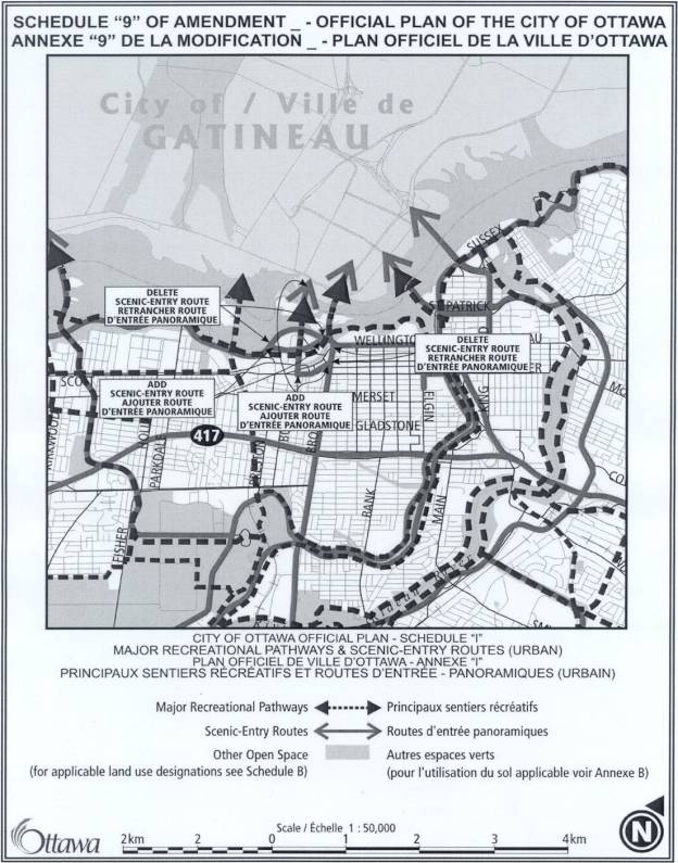
AMENDMENTS TO THE 2003
OTTAWA OFFICIAL PLAN -- MINOR POLICY CHANGES AND CORRECTIONS
MODIFICATIONS AU PLAN OFFICIEL
D’OTTAWA DE 2003 –MODIFICATIONS DE POLITIQUE MINEURES ET CORRECTIONS
ACS2004--DEV-POL-0035 city wide
Acting Chair Holmes began by reading a statement required under the Planning Act, which advised that anyone
who intended to appeal this proposed Official Plan Amendment to the Ontario
Municipal Board (OMB), must either voice their objections at the public
meeting, or submit their comments in writing prior to the amendment being adopted
by City Council. Failure to do so could result in refusal/dismissal of the
appeal by the OMB.
N. Lathrop, J.
Moser, Judy
Flavin, Planner, Carol Christensen,
Steven Boyle and T. Marc appeared before the
Committee with respect to departmental report dated 12 July 2004.
The Committee
heard from the following delegations:
Joe Gulli provided a comprehensive written submission that
was circulated to the Committee and is held on file with the City Clerk. Mr. Gulli objected to Volume 2A - Secondary
Plans for Longfields, Davidson Heights Communities, South Merivale Business
Park Secondary Plan - Area 1, 2, and 3.
The amendment proposes to delete the requirement that this residential
area on private services be used only for the existing single-detached houses
and allows Council to consider new lot creation subject to the policies in
Volume 1 of the Plan. He did not object
to the whole policy, but only the part that dealt with the
airport..."These policies include policies on land use constraints due to
aircraft noise and development on private services in public service
areas." He asked for a severance
on his property based on the facts presented in his submission.
As a result of
the presentation, Councillor Cullen received confirmation that the policy changes
did not affect the status of Mr. Gulli’s property. The Councillor suggested Mr. Gulli had an issue with severance
that should come before the OMB. Mr.
Gulli explained he was asking that additional changes be implemented that
stipulate that because of Transport Canada Guidelines there are alternatives
with respect to certain properties. He
reiterated the OP did not take into consideration that Noise Exposure Forecast
(NEF) contours are out of date.
In response to
A/Chair Holmes, Ms. Flavin clarified that the issue that impacted Mr. Gulli is
the fact his lot is located above the 35 NEF line in the OP, which does not
permit residential development. It also
sets restrictions below the 35 out to the edge of the Airport Operation
Influence Zone (AOIZ). Responding
further, Ms. Flavin elucidated the Ottawa Airport Authority (Authority) has the
authority to set the NEF/Noise Exposure Projection (NEP). The City is using current NEF/NEP contours
in effect through the Authority, but could not say what data that is based
upon. Mr. Gulli posited it states it is
based on 1994 data.
Annette
Nicholson, Ottawa Airport Authority, was available to respond to
any questions the Committee might have.
A/Chair Holmes asked if the City was using 1994 data.
Ms. Nicholson explicated that the line of the AOIZ is based on the most current
contours available and the Authority has been referring to the 1994 NEF
contours. She explained there are two
contours at each of the numerical lines – 35, 30, 25 and the NEP is based upon
a projection to the year 2014. This
will be reviewed. Responding further,
Ms. Nicholson stated the NEF line will very likely be looked at in the next few
years.
Barbara Barr,
GACC, provided a written submission in opposition that was circulated and is
held on file with the City Clerk. Ms.
Barr’s concerns centred on: Official Plan Section 2.2.2 Village
Boundaries; Official Plan Section 4.4.2 Private Water and Wastewater Servicing;
and, Official Plan Section 4.2 Adjacent to Land Use Designations. Ms. Barr also stated that GACC was
pleased to see wording changes that clarify and strengthen the natural
environment sections of the OP.
Councillor Cullen
referred to the suggestion by the delegation, OP S. 4.2, p. 132, No. 18, and
asked if there was a problem to add the words suggested. Ms. Flavin responded that staff is
recommending to restore a policy reviewed as part of the OP review through the
Committee and the public consultation process.
Through an editing error staff dropped that policy from the Plan as it
was adopted and it is simply brought forward as recommended. There was discussion at the time of
Committee consideration on including adjacent greenlands and fields and the
decision was made not to include those words, but she would need to verify
that.
Murray Chown,
Novatech, addressed the issue of airport noise and in particular the definition of
the AOIZ as presently described in the OP.
He was retained by the City to represent the position of this Committee
and Council with respect to the rezoning of 7 Deakin at the OMB. The Authority appeared before the Committee
expressing strong opposition to that rezoning.
Staff recommended against the rezoning, but the Committee saw fit to
support the rezoning as did Council.
Preparing for that Hearing, he spent considerable time reviewing the
AOIZ and how it was established. He
referred to p. 110 of the report, first paragraph, under 4.8.7, the definition
of noise uses; the current OP and the amendment before the Committee includes
places of worship as a noise sensitive use.
The case presented at the OMB stated the church at 7 Deakin was not a
noise sensitive use. Mr. Chown brought
to the Committte’s attention the first sentence of the last paragraph which
states “The boundary of the Ottawa Airport Operating Influence Zoning is based
on the 30 NEF and NEP contours.” This
has been and was interpreted in the mid-90’s to take the worst of the two
contours and used to define the AOIZ.
He circulated a plan that depicted the 1994 NEF in the area of Prince of
Wales and Hunt Club and highlighted the 7 Deakin and 44 Rideau Heights Drive,
which he represented. The map
illustrates both properties fall within the 30 NEF contours and therefore
within the AOIZ boundary as defined in the OP.
He also provided the NEP 2014 mapping.
Both 7 Deakin and 44 Rideau Heights Drive fall well beyond the 30 NEP
contour. It begs the question as to why
the City was forced to defend their position at the OMB with respect to the
re-zoning of 7 Deakin. His current
client is in the same situation.
Although the
report before Committee is some minor tweaking of the OP, as approved by
Council, both in terms of wording and mapping, he posited the first presenter
asked and he would ask that the NEF/NEP contours be updated sooner rather than
later. It was his opinion the AOIZ
boundary, as currently reflected in the OP, greatly exaggerates the noise
influence from the Airport. It is
unfair to a number of property owners.
The Rideau Heights property is coming forward with applications to
change OP designations and zoning to allow for residential development, but the
first hurdle is that it is presently within the AOIZ and he opined the mapping
is out of date and needs to be dealt with swiftly. He encouraged the Committee to adopt a resolution or Motion
asking staff to work with the Authority to produce updated NEF/NEP mapping.
David Jeanes,
Transport 2000, provided a written submission of his comments in opposition, which is
held on file with the City Clerk.
Briefly, he commented on the following:
·
In item 7 “Champagne North” has been changed to “City Centre”.
·
The maps contained in the report showing the Rapid Transit Network are
much too small.
·
The change to the Rapid Transit Corridor @ Palladium, Schedule 2, takes a
nicely curved ROW and puts in two sharp-angled turns
·
The cross river links are not reflected on the map.
·
Deletion of the north/south light rail potential future branch south of
Leitrim to Armstrong, Schedule 5, p.143
·
The Inter-provincial study will show that it makes sense to extend light
rail north to the Casino and if that is done, the Ontario Government will
fundamentally object if no similar plan is possible at the south end to serve
the Rideau Carleton Slots. That may
result in a political impasse over two natural extensions of light rail.
As a result of
the presentation, Councillor Cullen questioned why the north/south rail and
link into Barrahaven was deleted. Mr.
Lathrop explained that the link to Barrhaven is not being removed and,
referring to p. 143, clarified that Councillor Cullen was possibly referring to
the extension, which goes south towards Osgoode along the rail. The two arrows are meant to represent the
extension on the righthand side. He and
Mr. Jeanes had an opportunity to discuss this matter prior to the meeting. Staff illustrated the deletion on the map to
reflect Council commitments and policies currently in place. But, he did agree with Mr. Jeanes that it is
Council policy to support access to the Slots, notwithstanding access to the
Ex. On principle, Mr. Jeanes has a good
point and he would suggest if the Committee were to accept the staff report,
save and except for that particular item, he would not have any objection.
In terms of the
Transportation Master Plan (TMP) and the Transit Study, the intent behind those
two studies was to show not only what would happen within the 20 year time
frame of this plan, but also potentially beyond and that is why arrows are
depicted as conceptual locations for extensions. Mr. Jeanes is quite correct in noting there is a commitment that
in the Transit Study the City will be looking at linkages across the river,
including the Prince of Wales bridge.
He shared with Transport 2000 the keenness in the potential of extending
light rail across the Prince of Wales bridge, but it should be done
comprehensively. That is why staff is
including all potential locations at all potential bridge sites, including the
Prince of Wales crossing. Staff will
note Mr. Jeanes and Transport 2000 concerns to ensure the City proceeds with
the Transit Study together with Gatineau and the NCC. Having received that information, Councillor Cullen indicated he
would present the following Motion: That the deletion to Schedule 5 regarding
the “Future Rapid Transit Corridor Alignment to be defined” extending south of Leitrim be retained.
Janet Bradley was present to
respond to any questions, if necessary, on behalf of Canada Lands
Corporation.
Pamela Sweet,
FoTenn Consultants, representing Rideau Carleton Raceway, reiterated the
comments expressed by Mr. Jeanes and Mr. Lathrop’s response. The Raceway basically supported the
re-wording regarding the Racetrack, which is not an issue, but there was a
concern with the removal of that future transit link. The Raceway would support the idea of having it remain in the OP
as indicated in the forthcoming Motion from Councillor Cullen.
Moved by
Councillor A. Cullen:
That the deletion to Schedule 5 regarding
the “Future Rapid Transit Corridor Alignment to be defined” extending south of
Leitrim be retained.
CARRIED with
Councillor G. Hunter dissenting.
Moved by
Councillor A. Cullen:
That the following staff technical
amendments be approved:
3. an Official Plan Amendment to correct errors in the 2003
Ottawa Official Plan and make editorial changes, as shown in Document 3
attached, subject to the following
amendments:
i.
That in item 11, the words
“Provisions for Retail” be deleted and “General Urban Area” be inserted in
their place, to correct a reference to an Official Plan section;
ii.
That a new item 12 be inserted
after item 11, that states “Section 3.6.7 Major Urban Facilities is hereby
amended by deleting the words ‘Lot 24’ and inserting the words ‘Lot 25’ in
policy 3”;
iii.
That in item 25, the words “Section
4.7” be deleted and “Section 4.8” be inserted in their place, to correct a
reference to an Official Plan section;
iv.
That
a new item 31 be inserted after item 30, that states “Schedule F – Central
Area/Inner City Road Network is hereby amended by changing the designation of
the Arterial – Proposed (Alignment Defined) in LeBreton Flats to Arterial –
Existing, inserting the new street name ‘Wellington’, deleting the existing
road and name ‘Ottawa River Parkway’, deleting the existing road name
‘Wellington’ and changing the road name ‘Scott’ to ‘Albert’, as shown in Schedule 7 attached”;
v.
That
a new section d) be inserted to item 32 that states “deleting the Scenic-Entry
Route designation of Bronson Avenue north of Albert Street and inserting a
Scenic-Entry Route on Albert and CommissionerStreets between Bronson Avenue and
Booth Street, and on Booth Street from Albert north to the Chaudière Bridge, as
shown in Schedule 9 attached.”
vi.
That
a new section e) be inserted to item 32 that states “deleting the Ottawa River
Parkway and Scenic-Entry Route designation in LeBreton Flats and adding the new
portion of Wellington and a Scenic-Entry Route designation west of the Portage
Bridge, as shown on Schedule 9 attached”.
vii.
That
the section numbers and schedule numbers be amended appropriately.
4. an Official Plan Amendment to correct and make minor policy
changes to Annex 1 regarding road classifications and rights-of-way, as shown
in Document 4 attached, subject to
the following amendments
i.
That the existing item 7 clause g) be modified by
replacing the word “Richmond” with the words “Wellington St. West”.
ii.
That the existing item 7 clause j) be modified by
replacing the two references to the word “Wellington” with the word “Albert”.
iii.
That the existing item 7 clause k) be deleted and
replaced with the following: “In the ROW listing for Wellington/Albert Street
between Champagne and Booth the words
‘Wellington/Albert’ be replaced with ‘Albert’ and the word ‘Champagne’ be changed to ‘Champagne
North’.”
iv.
That a new clause l) be inserted to item 7 that
states “In the ROW listing for Albert/Wellington between Booth and Empress that
the words ‘Albert/Wellington’ be replaced with the word ‘Albert’.”
v.
That a new clause m) be inserted to item 7 that
states “In the ROW listing for Richmond Road between Golden and Terminus at
Western that the words ‘Terminus at Western’ be replaced with the words ‘Island
Park’.”
vi.
That a new clause n) be inserted to item 7 that
states “In the ROW listing for Wellington Street between Western and Terminus
at Somerset that the word ‘Wellington’ be replaced with the words ‘Wellington
St. West’ and that the word ‘Western’ be replaced with the words ‘Island
Park’.”
vii.
That a new clause o) be inserted to item 7 that
states “In the ROW listing for Parkdale Avenue between Ottawa River Parkway and
Richmond that the word ‘Richmond’ be replaced with the word ‘Wellington St.
West’.”
viii.
That a new clause p) be inserted to item 7 that
states “In the ROW listing for Wellington between Proposed Lebreton and Rideau
that the words ‘Proposed Lebreton’ be replaced with the words ‘Portage
Bridge’.”
ix.
That a new clause q) be inserted to item 7 that
states “A new ROW listing be added for Wellington Street to read ‘Wellington’
from ‘Ottawa River Parkway’ to ‘Portage Bridge’ with a ROW to be protected of
‘40m’.”
x.
That a new clause g) be added to item 8 that states
“The ROW for LeBreton (proposed new boulevard) be deleted in its entirety.”
xi.
That a new clause h) be added to item 8 that states
“In the ROW for Preston extension the word ‘Wellington’ be replaced with the
word ‘Albert’ and that the words ‘Proposed Lebreton Blvd.’ be replaced with the
word ‘Wellington’.”
xii.
That a new clause lll) be added to item 19 that
states “In the ROW listing for McCormick Street the word ‘Wellington’ be
replaced with ‘Wellington St. West’.”
xiii.
That the section numbers numbers be amended
appropriately.
CARRIED
Councillor Cullen
referred to the request by Mr. Chown to speak to the Authority on updating the
Noise Contours and asked if direction could be given to staff. Mr. Lathrop undertook to ask the Authority
when it was anticipated the contours will be updated.
Councillor Hunter
followed on that matter and asked if there was another way to obtain the most
updated contours without going through the Authority. In his experience, the Authority appears at Committee on behalf
of maintaining the NEP and AOIZ as wide as possible and to keep property value
in its vicinity depressed and to discourage development, which isn’t their own,
in the airport area. Asking the
Authority to be responsible for updating the AOIZ is akin to “asking a wolf to
look after the henhouse”. Is there
another venue to achieve what is fair not only to the Airport, but to the
citizens and property owners in the environs?
Ms. Christensen explained it is the Authority’s responsibility to update
that mapping. What is illustrated in
the OP is the most recent. A/Chair
Holmes asked if it was possible to receive comments from Transport Canada. Councillor Hunter posited it is important,
on behalf of the City’s property owners, citizens and the Airport to ensure the
most up to date information is available.
It should be done in concert with Transport Canada, not the
Airport. Mr. Lathrop affirmed the Councillor
made a good point and the Airport is no longer considered a public entity. Staff would take that as an undertaking and
will proceed to identify exactly how Noise Cones are defined and identified in
the future through Transport Canada and report back to the Committee.
The Committee
approved the recommendations as amended.
That Planning and Environment Committee recommend
that Council approve:
1. an Official Plan Amendment to make minor policy changes in
response to appeals of the 2003 Ottawa Official Plan, as shown in Document 1
attached,
2. an Official Plan Amendment to make other minor policy
changes to the 2003 Ottawa Official Plan, as shown in Document 2 attached,
3. an Official Plan Amendment to correct errors in the 2003
Ottawa Official Plan and make editorial changes, as shown in Document 3
attached, subject to the following
amendments:
i.
That in item 11, the words “Provisions for Retail” be deleted and
“General Urban Area” be inserted in their place, to correct a reference to an
Official Plan section;
ii.
That a new item 12 be inserted after item 11, that states “Section
3.6.7 Major Urban Facilities is hereby amended by deleting the words ‘Lot
24’ and inserting the words ‘Lot 25’ in policy 3”;
iii.
That in item 25, the words “Section 4.7” be deleted and “Section 4.8”
be inserted in their place, to correct a reference to an Official Plan section;
iv.
That a new item 31 be inserted after item 30,
that states “Schedule F – Central Area/Inner City Road Network is hereby
amended by changing the designation of the Arterial – Proposed (Alignment
Defined) in LeBreton Flats to Arterial – Existing, inserting the new street
name ‘Wellington’, deleting the existing road and name ‘Ottawa River Parkway’,
deleting the existing road name ‘Wellington’ and changing the road name ‘Scott’
to ‘Albert’, as shown in Schedule 7
attached”;
v.
That a new section d) be inserted to item 32
that states “deleting the Scenic-Entry Route designation of Bronson Avenue
north of Albert Street and inserting a Scenic-Entry Route on Albert and
Commissioner Streets between Bronson Avenue and Booth Street, and on Booth Street
from Albert north to the Chaudière Bridge, as shown in Schedule 9 attached.”
vi.
That a new section e) be inserted to item 32
that states “deleting the Ottawa River Parkway and Scenic-Entry Route
designation in LeBreton Flats and adding the new portion of Wellington and a
Scenic-Entry Route designation west of the Portage Bridge, as shown on Schedule
9 attached”.
vii.
That the section numbers and schedule numbers
be amended appropriately.
4. an Official Plan Amendment to correct and make minor policy
changes to Annex 1 regarding road classifications and rights-of-way, as shown
in Document 4 attached, subject to
the following amendments
i.
That the existing item 7 clause g) be modified by
replacing the word “Richmond” with the words “Wellington St. West”.
ii.
That the existing item 7 clause j) be modified by
replacing the two references to the word “Wellington” with the word “Albert”.
iii.
That the existing item 7 clause k) be deleted and
replaced with the following: “In the ROW listing for Wellington/Albert Street
between Champagne and Booth the words
‘Wellington/Albert’ be replaced with ‘Albert’ and the word ‘Champagne’ be changed to ‘Champagne
North’.”
iv.
That a new clause l) be inserted to item 7 that
states “In the ROW listing for Albert/Wellington between Booth and Empress that
the words ‘Albert/Wellington’ be replaced with the word ‘Albert’.”
v.
That a new clause m) be inserted to item 7 that
states “In the ROW listing for Richmond Road between Golden and Terminus at
Western that the words ‘Terminus at Western’ be replaced with the words ‘Island
Park’.”
vi.
That a new clause n) be inserted to item 7 that
states “In the ROW listing for Wellington Street between Western and Terminus
at Somerset that the word ‘Wellington’ be replaced with the words ‘Wellington
St. West’ and that the word ‘Western’ be replaced with the words ‘Island
Park’.”
vii.
That a new clause o) be inserted to item 7 that
states “In the ROW listing for Parkdale Avenue between Ottawa River Parkway and
Richmond that the word ‘Richmond’ be replaced with the word ‘Wellington St.
West’.”
viii.
That a new clause p) be inserted to item 7 that
states “In the ROW listing for Wellington between Proposed Lebreton and Rideau
that the words ‘Proposed Lebreton’ be replaced with the words ‘Portage
Bridge’.”
ix.
That a new clause q) be inserted to item 7 that
states “A new ROW listing be added for Wellington Street to read ‘Wellington’
from ‘Ottawa River Parkway’ to ‘Portage Bridge’ with a ROW to be protected of
‘40m’.”
x.
That a new clause g) be added to item 8 that states
“The ROW for LeBreton (proposed new boulevard) be deleted in its entirety.”
xi.
That a new clause h) be added to item 8 that states
“In the ROW for Preston extension the word ‘Wellington’ be replaced with the
word ‘Albert’ and that the words ‘Proposed Lebreton Blvd.’ be replaced with the
word ‘Wellington’.”
xii.
That a new clause lll) be added to item 19 that
states “In the ROW listing for McCormick Street the word ‘Wellington’ be
replaced with ‘Wellington St. West’.”
xiii.
That the section numbers numbers be amended
appropriately.
5. That the deletion to Schedule 5 regarding the “Future
Rapid Transit Corridor Alignment to be defined” extending south of Leitrim be
retained.
CARRIED as amended