1.
TERRY FOX DRIVE - RICHARDSON SIDE ROAD TO GOULBOURN
FORCED ROAD (ENVIRONMENTAL ASSESSMENT ADDENDUM)
PROMENADE
TERRY-FOX - ROUTE SECONDAIRE RICHARDSON AU CHEMIN GOULBOURN FORCED (ADDENDA À
L'ÉVALUATION ENVIRONNEMENTALE)
|
COMMITTEE RECOMMENDATIONs
That Council approve:
1. The
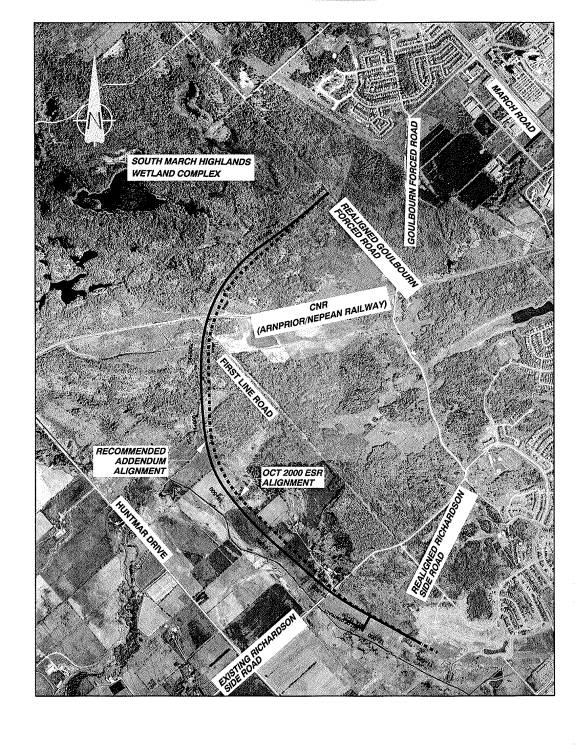
Environmental Assessment Addendum recommendation, as illustrated in Document 1
Recommended Addendum Alignment, to modify the roadway alignment, the roadway
cross-section, and the property requirements for the future railway grade-separation
of Terry Fox Drive between Richardson Side Road and Goulbourn Forced Road.
2. The
finalization and filing of the Terry Fox Drive - Richardson Side Road to
Goulbourn Forced Road - Environmental Assessment Addendum Report detailing the
above noted recommendations.
Recommandations
DU COMITÉ
Que le Conseil municipal
approuve :
1. la recommandation de l’addenda à l’Évaluation
environnementale, comme l’illustre le document 1 intitulé Addenda au tracé
recommandé, en vue de modifier le tracé de la route, l’intersection ainsi que
les exigences foncières pour aménager le futur croisement à saut-de-mouton de
la promenade Terry-Fox, entre la route secondaire Richardson et le chemin
Goulbourn Forced;
2. l’achèvement et la présentation du
Rapport d’addenda à l’Évaluation environnementale de la promenade Terry-Fox –
de la route secondaire Richardson au chemin Goulbourn Forced – dans lequel les
recommandations susmentionnées sont décrites.
Documentation
1.
Deputy
City Manager, Planning and Growth Management report dated 28 July 2004
(ACS2004-DEV-POL-0021), including additional information Memorandum dated
22 September 2004, attached to report as Document 7.
2.
Extract
of Minutes, 1 September 2004.
3.
Extract of Draft
Minutes, 6 October 2004.
Report to/Rapport au :
Transportation Committee
Comité des transports
and Council / et au Conseil
28 July 2004 / le 28 juillet 2004
Submitted by/Soumis par : Ned Lathrop, Deputy City Manager / Directeur
municipal adjoint
Planning
and Growth Management / Urbanisme et Gestion de la croissance
Contact Person/Personne
ressource : Vivi Chi, Manager / Gestionnaire
Transportation and Infrastructure / Transports et
infrastructure
(613) 580-2424 x21877, vivi.chi@ottawa.ca
|
|
Ref N°: ACS2004-DEV-POL-0021
|
|
SUBJECT:
|
Terry fox drive - RICHARDSON SIDE ROAD
TO GOULBOURN FORCED ROAD (environmental assessment addendum)
|
|
|
|
|
OBJET :
|
PROMENADE
TERRY-FOX - ROUTE SECONDAIRE RICHARDSON AU CHEMIN GOULBOURN FORCED (ADDENDA À
L'ÉVALUATION ENVIRONNEMENTALE)
|
REPORT RECOMMENDATIONS
That
the Transportation Committee recommend Council approve:
1.
The
Environmental Assessment Addendum recommendation, as illustrated in Document 1
Recommended Addendum Alignment, to modify the roadway alignment, the roadway
cross-section, and the property requirements for the future railway
grade-separation of Terry Fox Drive between Richardson Side Road and Goulbourn
Forced Road.
2.
The
finalization and filing of the Terry Fox Drive - Richardson Side Road to
Goulbourn Forced Road - Environmental Assessment Addendum Report detailing the
above noted recommendations.
RECOMMANDATIONS DU
RAPPORT
Que le Comité
des transports recommande au Conseil municipal d’approuver :
1. la
recommandation de l’addenda à l’Évaluation environnementale, comme l’illustre
le document 1 intitulé Addenda au tracé recommandé, en vue de modifier le tracé
de la route, l’intersection ainsi que les exigences foncières pour aménager le
futur croisement à saut-de-mouton de la promenade Terry-Fox, entre la route
secondaire Richardson et le chemin Goulbourn Forced;
2. l’achèvement
et la présentation du Rapport d’addenda à l’Évaluation environnementale de la
promenade Terry-Fox – de la route secondaire Richardson au chemin Goulbourn
Forced – dans lequel les recommandations susmentionnées sont décrites.
BACKGROUND
The Terry Fox Drive Environmental Study Report (ESR),
Eagleson Road to March Road was completed by the former Region and filed in
October 2000. Regional Council, on 27
September 2000, approved a report to advance several key infrastructure
projects, in response to rapid growth, that included the preliminary design of
Terry Fox Drive between Richardson Side Road and March Road. The preliminary design recommended a number
of modifications to the 2000 ESR to resolve conflicts, improve road design,
improve safety, address the anticipated increased transportation demand, and
reduce the impact on geographic features (rocky hill tops). The proposed modifications were deemed to be
significant enough to require the completion of an Environmental Assessment
(EA) Addendum to the 2000 EA.
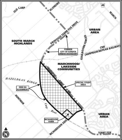
The 2000 ESR alignment of Terry Fox Drive,
which generally follows the floodplain of the Carp River (west of the urban
boundary), was adopted into the City's new Official Plan (OP) in May 2003. The location of the approved alignment
relative to the urban boundary raised the prospect that the urban boundary could/would
be considered for expansion. In
accordance with Council direction at the adoption of the City's new OP a
Special Study Area (SSA) was initiated to address the potential for the
development of this land and provide for the protection of natural environment
areas. (See the Key Plan below) The SSA applies to the land between the 2000
ESR alignment of Terry Fox Drive and the former urban boundary of the City of
Kanata.
The Terry Fox Drive EA Addendum analysis
considered the findings of the SSA study, and the final recommendations of the
EA Addendum reflect the staff recommendations on land use designations in the
SSA.
Key Plan
DISCUSSION
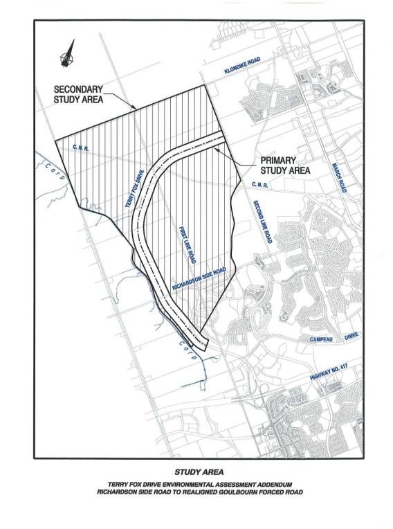
Terry Fox Drive EA Addendum - Study Area
Since alternative alignments for Terry Fox
Drive were already considered in the 2000 ESR, the primary study area for the
Addendum was in the immediate vicinity of the 2000 ESR alignment from
Richardson Side Road to Goulbourn Forced Road.
A secondary study area was also defined for the purpose of documenting
and evaluating the surrounding environmental issues.
The secondary study area includes the area
bounded on the south by Richardson Side Road, on the west side by the Carp
River, on the north side by Klondike Road and on the east side by the future
realigned Goulbourn Forced Road / Second Line Road. The secondary study area includes the South March Highlands
Wetland Complex, the headwaters of Shirley's Brook, Kizell Drain, the Carp
River, and various wooded or farmland areas.
(See Document 1 - Terry Fox Drive EA Addendum - Study Area)
Recommended Modifications to the
2000 Environmental Study Report
Recommended Modifications to the Horizontal
Alignment
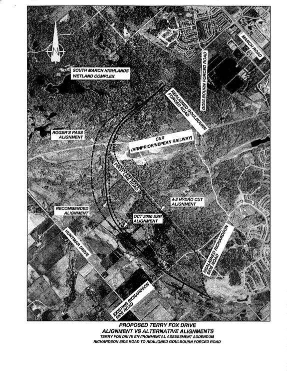
The review of the recommended modifications
along the corridor has resulted in a relatively small adjustment of the road to
the west. This shift in the alignment
resolves conflicts with recently constructed farm buildings on the Richardson
property (as noted on the Key Plan). It
also allows the development of a continuous curvilinear alignment that is more
in keeping with driver expectations adjacent to an open rural/parkway
setting. The overall result will be a
design that improves user safety by providing consistent and appropriate
feedback to drivers about the road ahead.
(See Document 3 - Alignment Alternatives)
The westerly shift in the alignment of Terry
Fox Drive will increase the encroachment of the road into the Carp River flood
plain. This proposed encroachment has
been discussed with the Mississippi Valley Conservation Authority (MVCA), and
the MVCA has agreed that the reduction in the flood plain will be addressed by
a Compensation Strategy, to be prepared during the detailed design phase. A separate rehabilitation strategy for the
Carp River is also currently in development to address degraded condition of
the river. The Terry Fox Drive
floodplain impact has been identified as an adjacent area that could be
incorporated into this rehabilitation strategy. The rehabilitation of the Carp River is a recommendation of the
Carp River Sub-watershed Study and the Kanata West Concept Plan.
The westerly shift increases the size of the
Special Study Area slightly and also increases the portion of environmentally
significant land east of the roadway.
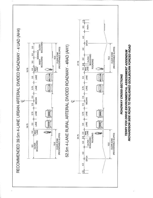
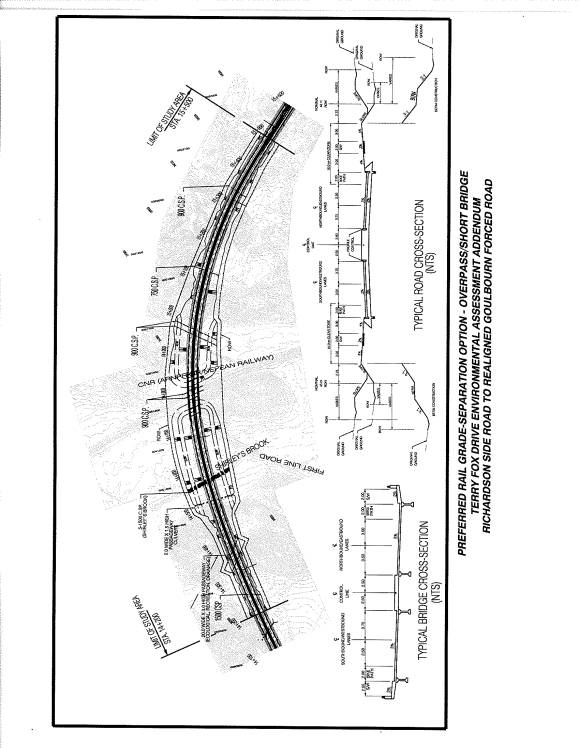
Recommended Changes to the Terry Fox Drive
Cross-section
The original concept for Terry Fox Drive from
Richardson Side Road to Goulbourn Force Road was a two-lane rural arterial
undivided cross-section that included a 2.5m bicycle lane in each direction and
a 2.0m sidewalk on the east/south side.
The 2000 ESR anticipated that the two-lane roadway could be expanded to
four lanes beyond the 2021 planning horizon.
The updated 2021 development levels identified in the new OP confirmed
that the two-lane cross-section will no longer be adequate to address the
anticipated increased demand.
The Transportation Master Plan (TMP) long-range
transportation model was adjusted to represent the planned growth predicted in
the new OP for adjacent lands, and it was concluded that four general purpose
traffic lanes would be required on the Terry Fox Drive corridor (Richardson
Side Road to Goulbourn Forced Road) prior to 2021.
The evaluation of safety requirements for the
four-lane roadway identified a center median as necessary to provide
appropriate separation of traffic. In
order to minimize the impact of the four-lane divided cross-section various
cross-section alternatives were tested to determine what combination would have
the least impact on the Natural Environment Area (NEA) land while still
providing acceptable standards for safety.
A reduced center-median width, and the use of
an urban cross-section with storm sewers was the recommended solution to
minimize the cross-section required for the four lanes, and avoid the extra
width required for a rural open drainage design. The four-lane urban cross-section significantly reduces rock
removal costs and its reduced footprint reduces impacts through environmentally
sensitive areas. (See Document 4 - Cross-Section Alternatives)
Recommended Railway Grade-Separation
The 2000 ESR did not address the future
requirement for a grade-separation at the former CNR - Renfrew Subdivision
railway line as it was initially found that a level crossing would be adequate
for the road and train traffic then predicted.
The increased road traffic projections and the continued protection of
the rail corridor for possible future transit has now supported the
investigation of grade-separation requirements. In addition, past and current OP's call for the identification
of appropriate right of ways to accommodate future grade-separations at all
active or potential road / railway crossings.
Therefore the Addendum includes design options for the railway crossing
with various bridge configurations to determine the most appropriate right of
way requirements at the crossing.
An overpass/short bridge option was selected as
the most preferred grade-separation strategy, as it allows the efficient
conversion of the initial at grade crossing to a future grade-separated
crossing, while providing equally favorable environmental and transportation
features to the other options. (See
Document 5 - Recommended Grade Separation)
ENVIRONMENTAL IMPLICATIONS
Environmental Impact Mitigation Strategy
In order for Terry Fox Drive to complete the link between Richardson Side Road and
Goulbourn Forced Road it is necessary for it to pass through a portion of the
South March Highlands, one of the most significant land forms in the City.
The construction of Terry Fox Drive will result
in five distinct impacts on the natural environment in the Study Area;
1.
a barrier to
ecological connectivity will be created between significant natural areas east
and west of the Terry Fox Drive corridor;
2.
the roadway
footprint will remove a section of the Provincially Significant wetland complex
southwest of the junction of Terry Fox Drive/ CNR rail line;
3.
the roadway
footprint will remove and disturb woodland habitat;
4.
the aquatic
environment of Shirley’s Brook and the Shirley’s Brook tributaries will be
degraded due to channeling waterways into culverts to pass under the road and
by roadway drainage; and
5.
the roadway will
reduce the Carp River floodplain volume.
Each of these impacts on the natural environment
will be addressed in detail in a Mitigation Strategy to be completed during the
detailed design phase of the roadway.
Nevertheless, during the 2000 ESR and the EA
Addendum Study a combination of strategies have been proposed to mitigate:
·
wetland impacts;
·
woodland habitat
impacts; and
·
aquatic habitat
impacts.
The alignment has been
selected to minimize the fragmentation of the wetland complex, and the
cross-section was developed to minimize the footprint of the roadway. Further consideration will be given to
opportunities to reduce the footprint through the wetland area during the
detailed design.
The impacts on the
aquatic habitats are to be addressed by compensation on adjacent development
lands. A joint initiative with the
development area east of the recommended alignment and DFO proposes relocation
and rehabilitation of Shirley's Brook to improve the quality of the habitat, by
adding base flow to Shirley's Brook, which is beneficial given its current low
base flows.
The impact on the Carp
River floodplain will be compensated/mitigated in coordination with the MVCA in
a detailed floodplain compensation plan for that will be prepared during the
detailed design phase. The compensation
options can include identification/protection of replacement storage areas,
modification of the Carp River to increase flood storage, or funding projects
elsewhere on the Carp River that improve flood performance. Alternatively the
floodplain compensation can be incorporated in the Carp River rehabilitation
strategy.
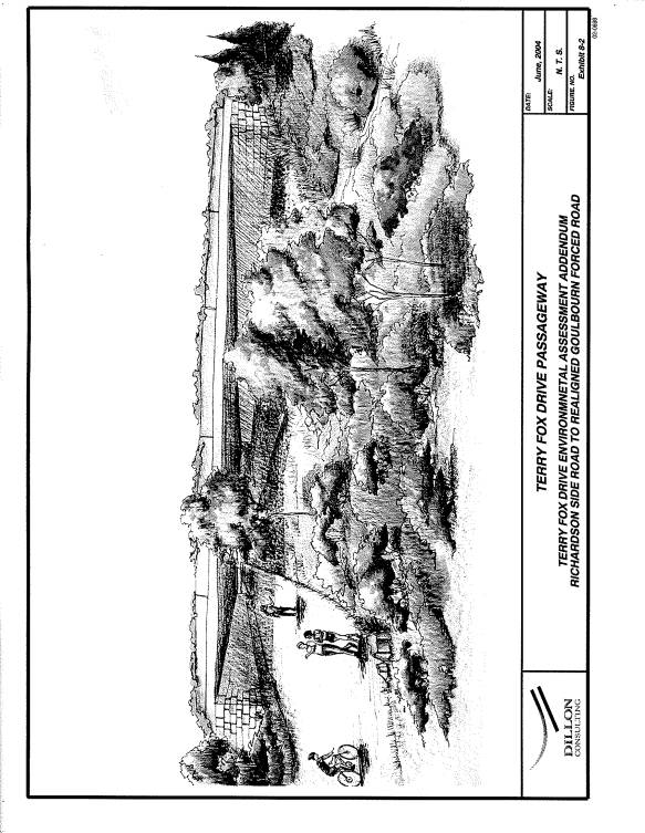
Initial investigations
undertaken during the Preliminary Design phase for Terry Fox Drive identified a
series of ecological passageways as the preferred method to mitigate the
barrier effect of the roadway and maintain ecological connectivity between natural
areas. The ecological passageway
network consists of smaller wet and dry passageways in key locations along
Terry Fox Drive and a single, larger ecological passageway to be located in the
highlands area southwest of the CNR crossing.
The Addendum Study
identifies a large (20m wide by 3m high) ecological passageway under Terry Fox
Drive as a possible method to mitigate the barrier effect of the roadway and
maintain ecological connectivity between natural areas. (See Document 6 - Terry Fox Drive Passageway)
Passageways such as the
one proposed have been used in other jurisdictions (such as Banff National
Park, Glacier National Park, Florida and Europe). While, biologists involved with these projects have indicated that
they believe the passageways to have been successful in reducing the impact of
roadways on important natural environment features, proof of the benefits of
such facilities can only be determined by long-term monitoring of ecological
activity. The estimated cost for the
passageway is $3.2 Million and has provisionally been included in the overall
cost estimate for the project.
An initial location for
the large passageway has been established by a 3 month study of patterns of
movement of uplands wildlife in the winter of 2001. The location should be confirmed through further observation of
movement patterns in other seasons. A
twelve month study of wildlife movements throughout a year would be the
preferred method for confirming the passageway location.
The EA Addendum study
has provided the opportunity to introduce the passageway and it was
accommodated in the evaluation of all the relevant alignment alternatives. The final decision on the appropriate size,
location and design of the passageway will take place during the detailed design
phase.
Several other small
roadway culvert / environmental passage crossings are also recommended in other
areas where a high incidence of wildlife activity has been documented.
Stormwater
Management
Four stormwater
management facilities are required to mitigate the impact of stormwater runoff
from the new road. The property
requirements for the stormwater management facilities have been identified in
the ESR Addendum. The preliminary
design allows for the maintenance of existing drainage patterns and overland
flows, but opportunities for integrated stormwater management can be
accommodated in the detailed design as dictated by adjacent land use. This was considered important since the
Special Study Area contemplated the development of some of the land east of
Terry Fox Drive.
Changes to
land use adjacent to the alignment
While the Addendum study
was underway, staff were also involved in the Special Study Area (SSA) review
which included public consultation and gave rise to alternative road alignment
reviews. The SSA review also proposed a
change to the land use of some land immediately to the east of the alignment
and a review of those lands deemed to be environmentally significant. The analysis undertaken for the Addendum
took into consideration that parts of the SSA may be subjected to future
development. This consideration has
been built into the Addendum recommendations.
RURAL IMPLICATIONS
The impact on existing rural land uses, such as the
impact on agricultural land, agricultural operations, wooded lands, and natural
environment areas was included in the evaluation of alternatives in the
original 2000 ESR and were updated in the evaluation of alternatives in the EA
Addendum Study.
The 2000 ESR acknowledged the loss of
agricultural land and the fragmentation of farmland caused by the approved
alignment. The EA
Addendum recommended alignment does not significantly change the nature
of these impacts.
CONSULTATION
A comprehensive consultation process was undertaken
for the EA Addendum.
Consultation activities included:
·
numerous
Technical Advisory Committee meetings;
·
discussions with
the Mississippi Valley Conservation Authority;
·
discussions with
local landowners; and
·
a Public Open
House.
While the Terry Fox Drive EA Addendum process
was underway the Special Study Area review was also conducted.
Assistance was provided at public meetings for
the Special Study Area regarding issues related to Terry Fox Drive. Several alternative alignment options were
proposed by the public at SSA meetings and these were then reviewed in detail
to determine their potential environmental impact. See Document 3 illustrating the alignments that were reviewed.
The reviews included an alternative alignment proposed
by a landowner (referred to as the Roger's Pass alignment in Document 3) and
the re-evaluation of the First Line road allowance (also know as option 4-2
Hydro Cut, see Document 3) alignment with the current four-lane requirement. Each of the alternative alignments were
reviewed together with the recommended alignment for their environmental
impacts. The recommended alignment
proved to be the superior alignment on the basis of least environmental impact
and least cost.
FINANCIAL IMPLICATIONS
The preliminary cost estimate to construct the
extension of Terry Fox Drive from Richardson Side Road to Goulbourn Forced Road
is approximately $34.9 million, excluding detailed design and property
acquisition. A more accurate total
project cost will be developed as detailed design is undertaken.
The construction of Terry Fox Drive from
Richardson Side Road to Goulbourn Forced Road is identified in Phase 3 of the
TMP (after 2013 and by about 2021). The
construction of the initial 2 lanes may be required to provide access to new
developments, therefore the timing of initial two lane construction may be
dependent on the phasing of development in north Kanata.
SUPPORTING DOCUMENTATION
Document
1 - Recommended Addendum Alignment
Document
2 - Terry Fox Drive EA Addendum Study Area
Document 3 - Alignment Alternatives
Document 4 - Cross-Section Alternatives
Document
5 - Recommended Grade Separation
Document
6 - Terry Fox Drive Passageway
Document 7 - *NEW* - Additional
information, Memorandum from Deputy City Manager, Planning and Growth
Management, dated 22 September 2004
DISPOSITION
Following Committee and Council approval, the ESR
Addendum Report documenting the addendum recommendations will be prepared and
filed for the 30-day public review period, in accordance with the provincial
Environmental Assessment Act.
Once the formal review period is over, and if
there is no Part II Order request to the Minister of the Environment, the
project will be considered approved.
The recommended modification of the Terry Fox
Drive alignment will be included in the appropriate schedule(s) of the City’s
Official Plan.
|
M E M O /
N O T E D E S E R V I C E
|

|
|
To / Destinataire
|
Councillor Stavinga,
Chair - Transportation Committee
|
|
|
From / Expéditeur
|
Ned
Lathrop, Deputy City Manager, Planning and Growth Management Department
|
|
|
Subject / Objet
|
Terry Fox Drive -
Richardson Side Road to Goulbourn Forced Road (Environmental Assessment
Addendum)
|
Date: 22 September 2004
|
The Terry Fox
Drive – Richardson Side Road to Goulbourn Forced Road Environmental Assessment
Study Addendum was presented to Transportation Committee at it’s 1 September
2004 meeting.
At
that meeting, Committee directed staff to provide additional written
information regarding the scope of the Environmental Assessment Addendum,
public consultation, evaluation and mitigation of the Carp River floodplain
issues, and the process for the evaluation and design of environmental
passageways. This memorandum has been
prepared to expand on the information contained in the staff report and to address
the concerns noted at Committee.
Scope of the Environmental
Assessment Addendum
The original
Terry Fox Drive Environmental Assessment set out the basic elements for the
roadway alignment and design for the extension of Terry Fox Drive from
Richardson Side Road to March Road. The
EA was approved in 2000. The EA
Addendum was undertaken to address three significant changes to the 2000
Environmental Study Report:
·
Modifications to the roadway alignment
·
Modifications to the roadway
cross-section, and
·
Specification of property requirements
for rail grade-separation.
The Addendum was
completed in accordance with the Municipal Class Environmental Assessment
(June 2000).
Public Consultation
Project
stakeholders were consulted during the development of the Addendum. Activities included consultation with the
following groups:
·
General Public
·
Technical Advisory Committee/ Approval
Agencies
·
Landowners
·
Special Study Area
The number and
type of consultation events, the issues or concerns raised, and the project
team responses are described below.
General Public
The primary
consultation event with the public at large was a Public Open House held on 3
December 2002 at the Kanata United Church located at 33 Leacock Drive in
Kanata. The Open House was a joint
event; presenting the recommendations of both the Terry Fox Drive EA Addendum
and the Kanata Lakes Development Serviceability, Environmental, and Recreation
studies. More than 150 people were in
attendance, including Councillor Alex Munter and staff from a variety of City
Departments.
The format of
the Open House was typical of City events for EA studies. A series of information boards were
available for review and the Consultant Project Manager made a
presentation. The recommended alignment
for the EA Addendum study was presented, along with the underlying rationale
for the westerly shift from the approved ESR alignment.
Comments from
the public on the study recommendations were collected in two ways:
(1) a question and answer period following the formal presentations; and
(2) comment sheets provided at the Open House.
The majority of
the people in attendance at the meeting were concerned with the Kanata Lakes
development proposal and the proposed compensation plan for the inadvertent
removal of trees from protected Natural Environment lands. Few comments were made regarding the EA
Addendum study. Comments that were
received are summarized below, along with the study team’s response.
|
Comment
|
Response
|
|
Existing Goulbourn Forced Road needs to
be reconstructed or the timing for the construction of Terry Fox Drive needs
to be advanced. The volume of traffic
on March Road is excessive and there are currently no other viable options.
|
The 1997 RMOC TMP suggests that the
extension/ widening of this portion of Terry Fox Drive will not take place
before 2006. With the EA approval in
place, the City will be in a position to advance the timing of construction,
should the need to do so be demonstrated.
The City monitors local traffic conditions and can re-evaluate its
priorities.
|
|
The alignment recommended for Terry Fox
Drive in the Addendum makes sense.
|
Comment noted.
|
|
Has the junction/ intersection of Terry
Fox Drive and the future light rail line been adequately considered?
|
The EA Addendum identified a preferred
design concept for a grade-separation at the junction of Terry Fox Drive and
the CNR line. The property envelope
required to construct the grade-separation will be protected, to preserve the
ability to implement a grade-separation in the future, should it be
necessary.
|
|
Has consideration been given to the
construction of a large transit station at the intersection of the rail
corridor and Terry Fox Drive?
|
A transit station was not considered at
this location. It is more likely that
any future transit station would be integrated with the community.
|
|
Terry Fox Drive should not be built in
the recommended alignment. It should
proceed westerly from its current alignment until it meets the rail tracks,
and then follow the rail tracks to Huntmar Road.
|
This area of the City is in need of
north-south capacity, given that March Road/ Eagleson Road is the only
existing north-south arterial. An
alignment that follows the rail tracks to Huntmar Road would not serve the
underlying demand for north-south travel.
|
|
How will the 1.5 m diameter culverts
serve the deer population (i.e., assist deer in crossing the road)?
|
The smaller culverts (the 1.5 m diameter
culverts) are intended to serve small-sized wildlife. Deer are large enough to cross the roadway
at-grade and they will likely do so.
(Headlight reflectors have become a standard method to warn deer of
oncoming cars, and are employed on roads and highways where crossing
incidents occur)
|
|
Selection of a floodplain alignment for
Terry Fox Drive extends the urban boundary to the west. This is a bad idea. The current urban boundary should be
maintained.
|
The location of the road and the location
of the urban boundary are two separate things. The roadway alignment has been chosen in a manner that will
minimize environmental impact (considering all aspects of the natural, human,
transportation, and cost environment).
The urban boundary will be located in a manner that makes sense,
through an independent study of relevant factors.
|
No other
comments have been received from the general public during the course of the EA
Addendum study.
Technical Advisory Committee/ Approval Agencies
As is typical
with EA studies for the City of Ottawa, a Technical Advisory Committee (TAC)
was struck to provide guidance to the Terry Fox Drive EA Addendum. Membership on the TAC consisted of
representatives of the following groups:
·
Mississippi Valley Conservation
Authority
·
City of Ottawa – Planning & Growth
Management Department (Planning, environment and Infrastructure Policy Branch;
Planning & Infrastructure Approvals Branch)
·
City of Ottawa – Public Works &
Services Department (Infrastructure Services Branch)
Three progress
meetings were held with the TAC. Draft
designs for the roadway and strategies for environmental mitigation were
discussed and comments were incorporated into the design for Terry Fox Drive as
it evolved.
Representatives
of the Mississippi Valley Conservation Authority (MVCA) were in attendance at
the TAC meetings and at a number of stakeholder meetings related to the
preliminary design study. The impact of
the change in the alignment on the Carp River floodplain was discussed and
accepted in principle (by the MVCA) subject to the development of an acceptable
mitigation strategy during the detailed design phase. The MVCA provided an opinion that the loss of floodplain storage
will have a negligible effect on the Carp River's flow regime since the Carp
River is wide and shallow in the vicinity of the proposed Terry Fox Drive
alignment.
Landowners
During the EA
Addendum study, two meetings were held with three major landowners adjacent to
the Terry Fox Drive alignment (Minto, KNL Developments, Regional Group), and
four additional meetings were held to discuss the details of the preliminary
design... Several of the landowners were active in the
preparation of development concepts, and every effort was made to coordinate
the design of the road and its ancillary facilities (e.g., stormwater
management ponds) with the plans of subdivision. The topics of the discussions fell into three general categories:
1.
One of the landowners was proposing a
minor westerly shift in the alignment, just north of the Richardson Farm. The proposed shift affected approximately
500 metres of the alignment and sought to push the road about 50 metres to the
west, at the point of maximum shift;
2.
One of the landowners proposed an
alternate alignment for Terry Fox Drive; one that would see the road generally
shift 200 metres to the west in the vicinity of the CNR crossing. This alignment alternative came to be known
as the Rogers Pass alternative; and
3.
Many of the landowners wanted to know
about design details such as location of proposed local road intersections,
shifts in the proposed profile, etc. As
Terry Fox Drive within the study area was simultaneously subject to a
preliminary design assignment, the majority of these concerns and questions
were referred to the preliminary design team and were satisfactorily addressed.
The minor shift
in the alignment north of the Richardson Farm was considered and the only
negative effect would be on the floodplain.
The MVCA was consulted regarding this proposal and it was accepted in
principle, subject to the development of an acceptable mitigation
strategy. The landowner requesting the
shift was advised and concurred that he would be responsible for all mitigation
to offset the additional floodplain impacts.
Six meetings
were held with the proponent of the Rogers Pass alignment (Kanata Highlands
Properties) to review the merits and potential impacts of the proposed westerly
shift in the alignment. Detailed
evaluation of the options showed that the Rogers Pass alignment would have the
following comparative effects:
· the Rogers Pass alignment would have a greater impact on the natural
environment than the recommended EA Addendum alignment, primarily as a result
of the impacts on the wetlands in the vicinity of the CNR tracks;
· the Rogers Pass alignment would remove 20,000 to 60,000 m3
more rock than the recommended EA Addendum alignment, primarily in the
environmental sensitive area southwest of the CNR tracks known as “the Saddle”;
and
· the Rogers Pass alignment would have a construction cost of $37
Million, approximately $3 Million more than the estimated $34 Million
construction cost for the recommended EA Addendum alignment.
The Rogers Pass
alignment was dismissed as a result of these incremental impacts.
The design
issues related to intersection location and roadway profile were referred to
the preliminary design team and the interested landowners were incorporated
into the consultation process for that study.
Special Study Area
The Terry Fox
Drive EA Addendum study team acted as a technical resource to the Special Study
of land use designations for the interstitial lands. The City and Consultant Project Managers attended all three of
the Steering Committee meetings and answered a range of questions from the
participants.
The primary
issue raised by the Special Study Area Land Use Study Steering Committee
related to Terry Fox Drive was the request to re-examine the Hydro Cut
alignment, in light of the conclusion that a four lane road would be required
on this portion of Terry Fox Drive (the ESR have originally concluded that only
two lanes would be needed before 2021).
The reasoning was that the right-of-way would be wider, possibly changing
the conclusions regarding the relative merit of the Hydro Cut as a road
alignment, compared to the floodplain alignment.
The evaluation
of the Hydro Cut alignment options revealed the following:
·
the impact of the Hydro Cut alignment
on the natural environment would be greater than the impact of the recommended
EA Addendum alignment, primarily as a result of the removal of a significant
area of woodland within the Compensation Land area;
·
the Hydro Cut alignment would require
the removal of 8 hectares of land designated for development, as a result of
trying to complete the west-to-south turn in Terry Fox Drive without impacting
further on natural areas; and
·
the Hydro Cut alignment would have a
construction cost of $38 Million, approximately $4 Million more than the
estimated $34 Million construction cost for the recommended EA Addendum
alignment.
Carp River
The Mississippi
Valley Conservation Authority has reviewed the proposed road alignment on
active farmland in the flood fringe adjacent to the Carp River. The MVCA has confirmed that they have no
objections to the proposed alignment and have identified no significant adverse
impacts on the natural function of the river based on the road location.
Calculations were completed, during the preliminary design, to
determine the loss of flood plain due to the new road alignment encroaching
into the Regulatory (100-year) flood plain of the Carp River. The cross
sections from the existing Conservation Authority HEC2 backwater model were
employed in the analysis. An estimated 45,000 cubic metres of floodplain
storage area will be lost due to the proposed EA Addendum alignment. The
proposed EA Addendum alignment is approximately 18,000 cubic metres more than
the 2000 ESR alignment that had a total impacted of about 27,000 cubic metres.
The MVCA is aware of this additional floodplain impact, and have agreed that
the loss of floodplain storage will have a negligible effect on the Carp
River’s flood regime since the Carp River is wide and shallow in the vicinity
of the proposed Terry Fox Drive alignment.
The general
MVCA requirements for the Terry Fox Extension within the Carp River flood
plain are as follows:
·
The road surface
must be above the 100-year flood plain elevation to ensure appropriate flood
proofing.
·
The loss of flood
plain storage due to the roadway footprint will be compared to the additional
flood plain storage created from the construction of any stormwater management
and any required fish habitat compensation works. Local grading that creates
additional storage can be used to compensate for any residue loss of flood plan
storage.
·
The cross culvert
near Station 13+400 must remain to allow the existing backwater flood plain
storage to remain upstream of the road.
These issues will be addressed during the detailed design
phase. Under Ontario Regulation 159/90 a permit will be required from
MVCA for any fill placement and/or construction within the Regulatory flood
plain of the Carp River. This process will ensure that the flood plain
issues will be addressed to the satisfaction of the MVCA.
Environmental Passageways
As noted in the
staff report the location and function of the conceptual environmental
passageways are subject to further refinement during the detailed design
stage. Additional studies of migration
patterns are recommended to verify the type and location of passageways. Decisions on land use within the Special
Study Area will be a critical factor in the size, type and location of passageways.
It is important
to note that the passageways depicted in the EA Addendum report are conceptual
and can be accommodated or deleted/modified without further changes to the
alignment or cross-section of the roadway.
Following
further wildlife studies and subject to final land use adjacent to the road
corridor, the actual environmental passageway plan will be presented to the
public and to Transportation Committee during the development of the detailed
design.
Yours truly,
Original
signed by Ned Lathrop
Ned Lathrop,
Deputy City Manager
Planning and Growth Management
TERRY
FOX DRIVE - RICHARDSON SIDE ROAD TO GOULBOURN FORCED ROAD (ENVIRONMENTAL
ASSESSMENT ADDENDUM) / PROMENADE TERRY-FOX - ROUTE SECONDAIRE RICHARDSON AU
CHEMIN GOULBOURN FORCED (ADDENDA À L'ÉVALUATION ENVIRONNEMENTALE)
Appearing before Committee to give
a PowerPoint presentation and answer questions on this report were were Ned
Lathrop, Deputy City Manager, Planning and Growth Management Department, Steven
Stoddard, Senior Project Manager, Bruce Finlay, Planner II and Shawn Doyle,
Dillon Consulting. A copy of the
PowerPoint presentation is held on file with the City Clerk.
In
response to questions raised by Councillor Feltmate, staff explained that the
alignment of the roadway is no more than 40 metres further west at the greatest
point and the conceptual alignment of the road was used as the boundary for the
special study area. The alignment will
only increase marginally the area of the special study in that regard. With regards to the proposal for a
passageway, staff advised that they looked at best practices to determine a
strategy for mitigating the loss of connectivity for small animals between the
areas east and west of the road. There
is insufficient scientific proof however, on the effectiveness of such
passageways, as it can take generations for the effects to become obvious.
Continuing
on this point, Councillor Legendre referred to the use of such passageways in
other cities, particularly in Banff where these overpasses allow for the safe
movement of large animals such as elk, across the highway. However, in this situation, where the
passageway is intended to permit the movement of both small animals and pedestrians,
he did not see the two working compatibly together. He also suggested the passageway would be better served by having
it as an overpass instead of an underpass because a tunnel for an animal is
visually confining. While staff advised
that the final design of the passageway is not yet known, it was noted that an
underpass provides greater opportunity to maintain a natural state in terms of
keeping a linkage for plant materials as well as grading and drainage. With regards to pedestrian use, the Deputy
City Manager advised that this would not be encouraged, although there would
probably be walking trails throughout the area rather than a formal
pathway. The councillor suggested a
mixed message was being sent because the detailed drawing in the report shows
people walking along what appears to be a paved pathway.
Councillor
Legendre was especially disappointed that the report did not include the
comments received during the public consultation period and found the report to
be unacceptable based on this serious omission. Staff concurred that while it would be included in the final
addendum report, such information should have been incorporated in the report
before committee.
When asked
whether approval of this report would see the urban boundary moved further
west, Mr. Lathrop advised that prior to the new Official Plan (OP), the urban
boundary was located on the hydro easement that formed the western boundary of
the Marchwood Lakeside Community in Kanata.
However, when the EA for Terry Fox Drive was underway and staff realized
that they were going to be recommending the Carp River alignment for the road,
they began looking at the land use implications of that sort of road movement
and thus recommended that part of that area become urban. He added that the policies in Section 3.11
of the new OP require staff to come forward with a confirmed recommendation on
the land use designations within that area and, as a consequence of that, the
new urban boundary. And, staff is
looking at the potential for development based on the best way to develop the
area, respecting existing floodplains and environmental protection areas. Notwithstanding that, he advised that staff
feel the best place to locate the road has been established and the Committee
and Council will have the ability, upon consideration of the land use
designations, to make the decision as to where the best place for urban
development will be. He confirmed that
the boundary is not automatically going to be Terry Fox.
Ed Balys,
Kanata Highlands Properties requested deferral of the matter because of
the short time he and other landowners of the KHP were given to respond to the
report. Further, and while they accept
the proposed route for the realignment, they were concerned about the intent
towards the use of the severed lands.
They have been working with the community on a land exchange proposal on
the basis that the lands severed and the lands inside the special study area
will be unsustainable as a natural environment area. The effect of the road and the tens of thousands of people that
will come into this area with development, would not allow for the pristine
conditions that constitute a natural environment area, but it could be
sustained as an urban park. If he
receives confirmation that the Committee would keep an open mind about the land
use in considering the realignment, he would withdraw his request for deferral.
Mr.
Lathrop advised that the Planning and Environment Committee (PEC) would be
responsible for considering the land use designation. He reiterated the fact that this route is the most appropriate
choice and results in the least amount of impact. When asked to comment on the impact of deferral, he advised that
there would be no value because the recommended route would not change
dependant upon the land use designation as decided by the PEC and Council. Mr. Balys accepted this statement and
withdrew his request for deferral.
Chair
Stavinga questioned the value of constructing a $3.2M passageway for small
animals when there are scarce capital dollars available. She recognized that in the national parks
there are other ways of enhancing the effectiveness of these facilities, such
as fencing along the highway to channel the large animals to the
passageway. Mr. Stoddard indicated
that there are smaller passageways that can be used for smaller species of
animals and confirmed that approval of this addendum does not mean approval of
the passageway, although it was developed as a mitigation concept through the
EA process. In response to further
concerns expressed by the Chair, he agreed to flag the budgetary concerns
associated with the passageway in the addendum report itself so that the future
Committees and Councils are aware of these details when the work comes back for
approval in 2010.
Councillor
Cullen pointed out that there are two passageways referred to as part of this
realignment, including one for the CNR that should not be used by
pedestrians. He felt it would be wise
to include a passageway that is designed for pedestrian usage.
Councillor
Legendre expressed disappointment at the lack of information in the report on
the following issues:
§
public consultation
§
the increase of the encroachment of the road into
the Carp River floodplain and the compensation strategy that is intended to
deal with this
§
the rehabilitation strategy for the Carp River
currently in development
§
degradation of the river as a result of the Terry
Fox alignment
Based on
the information provided, he was of the opinion that the alignment of the road
seems to be based on driver needs, not pedestrian needs or environmental
protection and he was deeply concerned that staff are unsure about the
feasibility and success of the passageway.
Mr. Lathrop agreed there was no pressing need to approve this report today
and was inclined to accept deferral to allow staff the opportunity to provide
clarification and the information requested.
Moved by
J. Legendre
That the EA Addendum be deferred to 6 October 2004* pending receipt of
the information developed during the public consultations and to allow staff to
provide any further environmental information on mitigation and impacts.
CARRIED
That the
Transportation Committee recommend Council approve:
1. The Environmental Assessment Addendum
recommendation, as illustrated in Document 1 Recommended Addendum Alignment, to
modify the roadway alignment, the roadway cross-section, and the property
requirements for the future railway grade-separation of Terry Fox Drive between
Richardson Side Road and Goulbourn Forced Road.
2. The finalization and filing of the
Terry Fox Drive - Richardson Side Road to Goulbourn Forced Road - Environmental
Assessment Addendum Report detailing the above noted recommendations.
DEFERRED
* It
was agreed that this would be the first item of business that day.
TERRY FOX DRIVE – RICHARDSON SIDE ROAD TO
GOULBOURN FORCED ROAD (ENVIRONMENTAL ASSESSMENT ADDENDUM) PROMENADE TERRY-FOX
– ROUTE SECONDAIRE RICHARDSON AU CHEMIN GOULBOURN FORCED (ADDENDA À
L’ÉVALUATION ENVIRONNEMENTALE)
ACS2004-DEV-POL-0021
DEFERRED FROM SEPTEMBER 1, 2004
Appearing before Committee to
answer questions on this item were Ned Lathrop, Deputy City Manager, Planning
and Growth Management (PGM), Steven Stoddard, Senior Project Manager, PGM, Shawn
Doyle, Dillon Consulting, Dan Brunton, Brunton Consulting Services and Sue Murphy, Planner II, PGM. The Committee received a memorandum from the
Deputy City Manager, providing additional information as requested at the
September 1 meeting, which is attached to the above-noted report and was distributed with the
agenda of this meeting.
In response to questions and
comments from Councillor Legendre about the passageway, Mr. Brunton responded
that the point of the passageway is not to replicate an urban landscape but to
facilitate communication between two sides of that natural area. It would be large enough to facilitate large
animals such as deer but this roadway is way too long through prime deer
habitat to be able to effectively mitigate it against those hits and there will
be lots of deer mortality along that road, which is unavoidable unless the
whole road is elevated. Fencing works
reasonably well for large animals such as deer and elk but does not work well
for wolves and smaller animals; they also cost millions of dollars to put in
place and are not really ecological.
Ms. Murphy informed that the primary purpose of the passageway is to
facilitate a connection in terms of the South March highlands for ecological
function and drainage. In response to
Councillor Legendre’s expressed disappointment about the comments of the
Mississippi Valley Conservation Authority (MVCA), Mr. Brunton stated that this
is, ecologically, a terrible place to put a road but, on balance, in
consideration of all other criteria, it has been decided that it is best to put
the road there if a road must be built.
He stated that the passageway would not guarantee that there would be
the desired connectivity but it will provide some potential for it. He further noted that there will be losses
in wetland habitat and substantial losses in upland habitat but conceded that
the passageway attempts to reduce that to the greatest degree possible and keep
in reasonable operation the most important functions for which the area was
defined. Mr. Lathrop added that staff
relies on the MVCA, respects their ability to make valuable recommendations,
and are satisfied about their comments with respect to the loss of land in the
floodplain being minimal. He pointed
out that such losses are something that staff tries to minimize as much as
possible and thus the reasoning for choosing this alignment.
Chair Stavinga pointed out that
she, like some other current Transportation Committee members, had not
participated in this process prior to 2000 and she felt that the memorandum
that had recently been provided by the Deputy City Manager was very helpful in alleviating some of her
concerns and perhaps those of other members as well. She suggested to staff for future reference that this type of
background information should be provided to Committee when dealing with
environmental assessments that have been approved by other bodies at another
point in time.
Councillor Feltmate pointed out
that Terry Fox is a very important transportation link in the west that is
intended to be part of a network with many more links, some of which are still
to be built. She felt that it should
proceed as quickly as possible given the development in the area that is
depending on it.
Councillor Bloess suggested that
there must be a better way of building this road and he opined that it will
compound negative environmental impacts.
When queried by Councillor Cullen,
Mr. Lathrop informed that the Official Plan designation for this area, dealt
with by the Planning and Environment Committee on 14 September, will rise to
Council concurrent with this report, on 27 October.
Councillor El-Chantiry felt that
every road in the area, not just Terry Fox, has deer problems and wondered why
special consideration is being given to the matter in light of this. Mr. Brunton concurred and pointed out that
the impact of this passageway on deer populations will be negligible and that
it will be more of an ecological passageway than a large animal passageway.
Ed Balys stated that the landowners have
agreed to donate 120 acres of March Highlands to expand the City-owned park
lands (the Regional Conservation Lands) and a further 20 acres of the north tip
of the special study area as park lands.
His concern lies with the fact that 500m of Terry Fox Drive will run
through this pristine escarpment area.
He conceded that it is not possible to make the road disappear, but he
suggested that the impacts could be greatly lessened by the sinking it into the
bedrock by about 2 metres, relocating the passageway to Shirley’s Brook and
placing the storm water catch pond on the west side of Terry Fox. Mr. Balys submitted written comments to this
effect, a copy of which is held on file.
Councillor Feltmate pointed out that the comments submitted by Mr. Balys
are a reflection of his own opinions and do not reflect those of most of the
community.
In response to Mr. Balys’
suggestions, staff provided the following comments:
·
The
profile of the area was set based on various constraints: a) engineering
constraints to design a roadway profile as a continuous line because it must
make sense in context of the overall roadway and not just the 500 metres that
Mr. Balys has referred to; b) the necessity to choose a profile that respects
the existing topography of the rock nulls as a key environmental feature; and
c) consideration of cost construction and the need to balance the amount of
material that would have to be removed to construct the roadway with the amount
of material that would have to be brought in to support it.
·
The
suggestion that the road could be narrowed through that area to 35metres is
misleading. The City’s standard for
arterial roadways would require at least 45 metres and beyond that there would
be engineering considerations requiring clear zones on the shoulders and to the
rock face.
·
The
profile can be looked at through the detail design phase and if there is an
opportunity to change or lower it, to the overall benefit of the project, it
can be accommodated outside of the Environmental Assessment Addendum process.
·
The
stormwater catch pond is located at the east side of the roadway because of the
existing topography of the land. The
roadway is passing through a large north to east curve and as it passes, the
road surface tilts slightly and all of the water will drain naturally to the
inside of the easterly part of the road.
It is possible to collect it and transfer it to the west side, but this
was not considered because the east side is the most logical placement for it
and a move to the west side might require a change in the profile of the road.
·
The
location of the passageway was based on several studies that determined that it
will not work elsewhere. It was
determined that, biologically, there is a need to allow the maximum amount of
ecological connectivity across this one natural area at that location.
Councillors Legendre, Cullen,
Bloess and Doucet were not in support of approval of this addendum and raised
following points:
·
there
seems to be some conflict between what was approved in 2000 and what is being
presented now with respect to the way this road does/does not determine the
urban boundary
·
it
is difficult to consider the roadway design without considering the planning
element. Should Council approve the
Planning and Environment Committee recommendation, a major part of the natural
environment area will become developed
·
several
projects in the past have been stopped or aborted because they did not protect
green spaces and did not fit with the urban landscape and values of the time
and there is still opportunity to change or stop this project, particularly as
the capital has not yet been approved
·
mitigations
being offered are not sufficient to offset the environmental impacts and damage
that will be done and this roadway will compound previous mistakes
·
the
world and its values have changed and the City will have to grow differently if
costs and environmental impacts are to be reduced and that can be achieved by
voting down projects such as this which harm the environment and spawn more
growth
Councillors Bédard, El-Chantiry, McRae,
Thompson and Stavinga were in support of the staff recommendations and raised
the following points:
·
the
majority of the community is in support of this project and would like it to
proceed as quickly as possible
·
the
MVCA have expressed their support of the mitigation measures
·
this
is an addendum process and not the appropriate time to make changes to the
overall project or try to stop it completely
Mr. Lathrop clarified that the
roadway itself was approved in 2000 as part of the environmental assessment
process. The fact that there will be a
route was stated as part of the Official Plan, the Transportation Master Plan,
as part of the growth of the Kanata urban area and as a needed link in the
transportation system around Kanata.
The Addendum attempts to mitigate environmental impacts by making
specifications, such as those related to property requirements for the rail
grade specifications which are needed in order to make sure that the east-west
railway line can be grade separated for future light rail. If this Addendum were not accepted by
Committee, the road would still proceed but without the mitigation
measures.
The Committee then considered the
report recommendation.
That the
Transportation Committee recommend Council approve:
1.
The Environmental Assessment Addendum recommendation, as illustrated
in Document 1 Recommended Addendum Alignment, to modify the roadway alignment,
the roadway cross-section, and the property requirements for the future railway
grade-separation of Terry Fox Drive between Richardson Side Road and Goulbourn
Forced Road.
2.
The finalization and filing of the Terry Fox Drive – Richardson Side
Road to Goulbourn Forced Road – Environmental Assessment Addendum Report
detailing the above noted recommendations.
CARRIED
Yeas (5): G. Bédard, E.
El-Chantiry, M. McRae, D. Thompson, J. Stavinga