3. ZONING - 495 RICHMOND
rOAD ZONAGE - 495, CHEMIN RICHMOND
|
COMMITTEE
RECOMMENDATIONS AS AMENDED
That Council approve an
amendment to the former City of Ottawa Zoning By-Law (1998) to change the
zoning of 495 Richmond Road from "CG1[421] F(1.0) SCH.60" to
"CG1[912] F(2.3) SCH.263" as detailed in Document 7.
And that no
further notice be provided pursuant to Section 34 (17) of the Planning Act.
RECOMMANDATIONS MODIFIées du COMITÉ
Que le Conseil approuve une modification au Règlement de zonage de 1998 de
l'ancienne Ville d'Ottawa afin de faire passer la désignation de zonage de la
propriété située au 495, chemin Richmond de « CG1[421] F(1.0) SCH.60 » à «
CG1[912] F(2.3) SCH.263 », ainsi que le précise le document 7.
Qu’aucun autre avis ne
soit donné conformément à l’article 34(17) de la Loi sur l’aménagement du
territoire.
Documentation
1. Deputy City Manager, Planning and
Growth Management report dated 8 November 2004
(ACS2004-DEV-APR-0228).
2. Extract
of Draft Minutes will be distributed prior to Council.
Report to/Rapport au :
Planning and Environment Committee
Comité de l'urbanisme et de
l'environnement
and Council / et au Conseil
08 November 2004 / le 08 novembre 2004
Submitted by/Soumis par : Ned Lathrop, Deputy City Manager
/ Directeur municipal adjoint
Planning and Growth Management / Urbanisme et Gestion de la croissance
Contact Person/Personne ressource : Grant Lindsay,
Manager / Gestionnaire
Development Approvals / Approbation des demandes
d'aménagement
(613) 580-2424 x13242,
Grant.Lindsay@ottawa.ca
|
SUBJECT: |
|
|
|
|
|
OBJET : |
REPORT RECOMMENDATION
1. That the Planning and Environment
Committee recommend Council approve an amendment to the former City of Ottawa
Zoning By-Law (1998) to change the zoning of 495 Richmond Road from
"CG1[421] F(1.0) SCH.60" to "CG1[912] F(2.3) SCH.263" as
detailed in Document 7.
2. That the By-law to
implement Recommendation 1 not be forwarded to City Council for enactment until
the applicant has obtained Site Plan Control approval for the proposed 24-storey
apartment and that incorporates an on-site pedestrian system that will allow
for a direct pedestrian connection to the Dominion Transitway Station through
the Ottawa River Parkway lands.
3. That the requirements set out in Recommendation 2 be satisfied within two years of approval of Recommendation 1, failing which this approval will lapse.
RECOMMANDATION DU RAPPORT
1. Que
le Comité de l'urbanisme et de l'environnement recommande au Conseil
d'approuver une modification au Règlement de zonage de 1998 de l'ancienne Ville
d'Ottawa afin de faire passer la désignation de zonage de la propriété située
au 495, chemin Richmond de « CG1[421] F(1.0) SCH.60 » à « CG1[912] F(2.3)
SCH.263 », ainsi que le précise le document 7.
2. Que le règlement municipal visant à
mettre en œuvre la recommandation 1 ne soit pas transmis au Conseil municipal
pour adoption tant que le requérant n'aura pas obtenu l'approbation du plan
d'implantation de l'immeuble d'habitation projeté, qui doit compter 24 étages;
ce plan d'implantation devra prévoir un réseau piétonnier comportant un lien
direct avec la station Dominion du Transitway, à travers les terrains de la
promenade de l'Outaouais.
3. Que les exigences énoncées à la
recommandation 2 soient satisfaites dans les deux ans suivant l'approbation de
la recommandation 1, à défaut de quoi cette approbation sera caduque.
EXECUTIVE SUMMARY
Assumptions
and Analysis:
Recommendation 1 is to approve an amendment to the former City of
Ottawa Zoning By-law to permit the development of a 24-storey apartment
building in the northeast corner of 495 Richmond Road. The proposed Zoning By-law amendment
supports a number of Official Plan objectives and policies including the following:
encouraging intensification and mixed-use development along Mainstreets;
promoting higher density development within 600 m of a rapid transit station;
achieving and maintaining a balance of housing types and tenures to provide a
full range of housing for a variety of demographic profiles; supporting the
ability to live, work, play, attend school and shop within the neighbourhood;
locating high profile residential development where there is minimal to no
impact on low profile residential areas; providing an appropriate transition
between high profile and low profile buildings, and ensuring the compatibility
of proposed development with a designated heritage resource.
The Council Approved Official Plan, the former Regional Official Plan
and the former City of Ottawa Official Plan all provide specific policy
direction that supports higher intensity development in proximity to Transitway
Stations and call for the provision of well-defined, safe, accessible and
convenient pedestrian circulation systems that integrate and connect such developments
with the Transitway Stations.
Recommendation 2 has been provided to ensure that the site plan
developed for the 24-storey apartment building will be developed in a way that
will ensure that this policy directive of all three plans will be satisfied. It allows for adjustments to be made to the
Zoning By-law with respect to yards that may be required once a determination
on the most appropriate on-site pedestrian circulation system that will provide
for the most appropriate connection to the Dominion Transitway Station.
Recommendation 3 has been included to set a time limit of two years for the applicant to obtain site plan approval for the proposed 24-storey apartment building and for City Council to enact the implementing Zoning By-law amendment. Staff believe that it is appropriate to set a deadline to enact the implementing By-law to ensure that the Zoning By-law amendment process is concluded within a reasonable period of time. In the event that site plan approval has not been granted within the set timeframe, the approval of the zoning change will be voided requiring the submission of a new application should future development be proposed that is beyond that allowed by the existing zoning.
Financial
Implications:
No costs are anticipated to be incurred by the City.
Public
Consultation/Input:
One community information and comment session was held for the application on September 14, 2004. The general public submitted over 200 written comments on the application. The concerns expressed by the public included the following: traffic impact; height and density of the proposed development; compatibility of the proposed development with low profile residential areas and the Maplelawn Estate; public access to the Ottawa River Parkway and the Dominion Transitway Station; and impact on views to the Ottawa River Parkway and the Gatineau Hills. The McKellar Park Community Association and the Highland Park Ratepayers Association submitted a petition signed by approximately 675 members objecting to the application.
RÉSUMÉ
Hypothèses et analyse :
La recommandation 1 vise à faire approuver
une modification au Règlement de zonage de l'ancienne Ville d'Ottawa afin de
permettre la construction d'un immeuble d'habitation de 24 étages dans l'angle
nord-est de la propriété située au 495, chemin Richmond. La modification
projetée au Règlement de zonage va dans le sens de plusieurs des objectifs et
politiques du Plan officiel, dont les suivants : favoriser le développement
polyvalent le long des rues principales; promouvoir des aménagements de plus
forte densité dans un rayon de 600 mètres des stations de transport en commun
rapide; assurer et maintenir un équilibre entre les différentes formes de
logements et les différents types d'occupation du sol, afin d'offrir une gamme
complète d'habitations pour différents profils démographiques; soutenir la
capacité de vivre, travailler et jouer ainsi que d'aller à l'école et de
magasiner dans le quartier; construire les immeubles de grande hauteur à des
endroits où ils auront peu ou point d'incidence sur les secteurs résidentiels
de faible hauteur; assurer une transition appropriée entre les immeubles de
grande hauteur et les immeubles de faible hauteur et assurer la compatibilité
des aménagements projetés avec les ressources patrimoniales désignées.
Le Plan officiel approuvé par le Conseil, l'ancien Plan directeur régional
ainsi que le Plan officiel de l'ancienne Ville d'Ottawa renferment tous des
orientations précises allant dans le sens d'une densification des aménagements
à proximité des stations du Transitway. Ils prévoient également l'établissement
de réseaux de circulation piétonnière bien définis, sécuritaires, accessibles
et pratiques permettant d'intégrer et de relier ces aménagements aux stations
du Transitway. La recommandation 2 vise à donner l'assurance que le plan
d'implantation de l'immeuble d'habitation de 24 étages donnera suite à cette
orientation. Elle permet que des correctifs soient apportés au Règlement de
zonage en ce qui concerne le nombre de cours qui pourrait être requis une fois
que l'on aura déterminé le réseau de circulation piétonnière le plus approprié,
qui offrira le meilleur lien avec la station Dominion du Transitway.
La recommandation 3 fixe un délai de deux ans durant lequel le requérant
devra obtenir l'approbation du plan d'implantation de l'immeuble d'habitation
de 24 étages projeté, tandis que le Conseil municipal devra adopter la
modification au Règlement municipal habilitant. Le personnel estime opportun de
fixer un tel délai afin d'avoir l'assurance que la modification du règlement de
zonage s'effectuera à l'intérieur d'une période raisonnable. Si, au terme du
délai fixé, le plan d'implantation n'a pas été approuvé, le changement de
zonage sera caduc, ce qui nécessitera la présentation d'une nouvelle demande si
l'on projetle un nouvel aménagement non permis par la désignation de zonage
actuelle.
Répercussions financières :
La Ville ne serait pas censée avoir de
frais à engager.
Consultation publique / commentaires :
Une réunion destinée à informer la
population sur le projet et à recueillir ses commentaires a eu lieu le 14
septembre 2004. Elle a soumis plus de 200 observations écrites sur la demande. Les
préoccupations qui y sont exprimées portent notamment sur les aspects suivants
: répercussions sur la circulation; hauteur et densité de l'ensemble projeté;
compatibilité de l'ensemble projeté avec les secteurs résidentiels de faible
hauteur et le domaine Maplelawn; accès public à la promenade de l'Outaouais et
à la station Dominion du Transitway; impact sur les vues de la promenade de
l'Outaouais et des collines de la Gatineau. L'association communautaire de
McKellar Park et l'association des contribuables de Highland Park ont soumis
une pétition signée par environ 675 de leurs membres opposés au projet.
BACKGROUND
495 Richmond Road is a 1.4 ha property located on the north side of
Richmond Road and east of Broadview Avenue as shown on the location map in
Document 1. The site has 89 m of
frontage on Richmond Road and a lot depth of approximately 118 m.
A seven-storey office building, known as the Denis Coolican
building, is located in the northwest corner of the site facing Richmond
Road. The building has a gross floor
area of 7576 sq. m and a building height of approximately 35 m. Vehicular access to Richmond Road is
currently provided by one full-movement driveway along the west side of the
site. The site contains approximately
359 parking spaces including 183 underground spaces and 176 surface spaces.
In terms of the site context, the Ottawa River Parkway and
associated open space corridor is located to the north of the site. To the northeast are two high-rise
apartments with heights of 20 and 13 storeys, with lower profile residential
uses beyond. To the east along Richmond
Road is a one-storey commercial building occupied by Rogers Television, with a
17-storey apartment building further to the east. Richmond Road forms the southern boundary of the site. An east-west open space corridor is located
between Richmond Road and Byron Avenue, and a residential area consisting of a
mix of low profile residential uses is located south of Byron Avenue.
Immediately to the west of the site is open space and the Maplelawn Estate, which includes Rochester House and the Maplelawn walled garden. Built in 1831-1834, Maplelawn Estate is designated under Part IV of the Ontario Heritage Act for its architectural and historical significance. Rochester House is also designated as "Classified" by the Federal Heritage Buildings Review Office, and the house and garden are designated as a National Historic Site. Rochester House is one of the best examples of Georgian domestic architecture in Canada, and the walled garden is considered to be the finest example and best preserved landscape of its type in Central Canada.
Initial Development Proposal
The applicant's initial Zoning By-law amendment submission was based on a three-phase development with a floor space index of 3.5 for the entire site. Phase 1 was proposed to include a six-storey mixed use building adjacent to Richmond Road with 34 dwelling units and ground floor retail. Phase 2 consisted of a 24-storey, 148-unit apartment building in the northeast corner of the site. In Phase 3, the applicant proposed to redevelop the Denis Coolican building with a 20-storey apartment building on the west side of the building. The applicant was also proposing to demolish the upper three storeys on the east side of the existing building, and retrofit the remaining four storeys for residential use. Phase 3 was proposed to contain 152 dwelling units. In total, 348 dwellings were proposed for the three phases. The applicant had also applied to reduce the side yard and rear yard setbacks to accommodate the Phase 2 and 3 buildings.
Revised Development Proposal
While the application was being processed, the applicant secured a long-term lease with a major office tenant for the Denis Coolican building. Following consultation with the Ward Councillor and the area Community Associations, the applicant amended the Zoning By-law amendment application on October 14, 2004, to remove the proposed Phase 3 development. The Phase 1 development was also modified to a 48-unit apartment building without any ground floor commercial uses. The Phase 1 building, called the Manor House, is proposed to have a gross floor area of 5710 sq. m. Phase 2 will consist of a 24-storey apartment building with 148-dwelling units and a gross floor area of 19 000 sq. m. In total, 196 dwelling units are proposed for the Phase 1 and 2 developments. The existing and proposed Phase 1 and 2 developments will have a floor space index of 2.3.
One new driveway is proposed on Richmond Road on the eastern side of
the site as part of the Phase 1 development.
Underground parking will be provided for both the Phase 1 and 2
apartment buildings. To accommodate the
Phase 2 building, the applicant is proposing to reconfigure the access to the
existing underground parking garage for the Denis Coolican building and to
relocate the loading spaces currently situated on the east side of the
building.
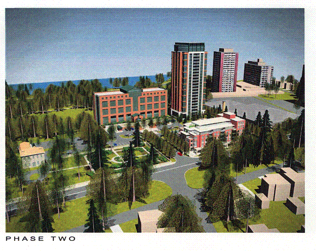
A Conceptual Site Plan of the proposed development is illustrated in
Document 2. Document 3 shows the
elevations of the proposed Phase 1 and 2 buildings looking north from Richmond
Road, and looking east from both the Maplelawn Garden and from the National
Capital Commission lands located west of the Maplelawn Estate. A bird's eye view of the proposed
development is shown in Document 4.
Purpose of Zoning By-law Amendment Application
The site is currently zoned "CG1[421] F(1.0) SCH.60",
which is a site-specific General Commercial Subzone with a maximum floor space
index of 1.0. The existing zoning
permits a range of residential uses including high-rise apartment buildings,
and a range of non-residential uses including offices, retail stores and
restaurants. The exception zone allows
a broadcasting station as an additional permitted use. The exception zone also requires special
yards for the commercial site to the east, and a landscape area of 35% of the
lot area. The Phase 1 development
(Manor House proposed along Richmond Road) is permitted under the existing
zoning as the maximum floor space index will not be exceeded.
The purpose of the Zoning By-law amendment application is to amend the zoning to allow the Phase 2 development as follows:
1) to increase the maximum floor space index from 1.0 to 2.3,
2) to reduce the side yard setback from 7.5 m to 6.0 m, and
3) to reduce the rear yard setback from 7.5 m to 4.0 m.
Concurrent Applications
The applicant has submitted a Site Plan Control application for the Phase 1 development. The application is being processed concurrently with the subject Zoning By-law amendment application.
DISCUSSION
Recommendation 1
Council Approved Official Plan
The Council Approved Official Plan designates the site as General Urban
Area. In addition, the property is subject
to the Mainstreet designation in the Official Plan that applies along Richmond
Road.
Managing Growth Within the Urban Area
The Council Approved Official Plan sets out a policy framework for
managing growth within the urban area that supports intensification and infill
inside the urban boundaries. The growth
management policies provide specific direction for Mainstreets to be developed
with more urban and more dense development that sensitively builds on existing
communities and is pedestrian supportive.
For the General Urban Area, the growth management policies provide
specific support for more intense development through infilling for lands
within 600 metres of future or existing rapid-transit stations where potential
exists to develop compact, mixed-use and pedestrian-friendly cores; for lands
where the present use is maintained, but the addition of residential uses or
other uses can be accomplished in a complementary manner; and for lands
currently used as parking lots or other extensive storage purposes.
The Growth Management Policies of the Council Approved Official Plan
support intensification and infill on the subject property. The site is subject to the Mainstreet
policies which given the site's proximity to the Dominion Transitway Station
(which is within 300 m walking distance of the site) and its current
development comprising a single office building and extensive surface parking,
the site exhibits great potential to be further developed to create a compact,
mixed-use node. The proposed zoning change will allow the site to be developed
in this manner. The applicant is
proposing to retain the existing office use and add residential uses in the
form of a six-storey apartment building along Richmond Road to create a more
dense and pedestrian oriented Mainstreet edge with a 24-storey apartment
building located to the rear of the site within walking distance of the
Dominion Transitway Station. Both
apartment buildings will replace existing surface parking areas.
Mainstreet Policies
The Mainstreet designation identifies areas that are characterized as
uninterrupted networks of active, mixed-use, pedestrian-oriented uses. Permitted uses within this designation
include retail stores, service establishments, offices, community-oriented facilities
and residential apartments.
The Official Plan policies encourage intensification along Mainstreets,
particularly where it will replace surface parking areas that interrupt the
continuity of the building facades along the street and specifically encourages
intensification and mixed use developments along arterial roads such as
Richmond Road. Change and renewal along
Mainstreets is intended to be carried out in accordance with the principle of
creating an environment that is architecturally pleasing, lively in its mix of
uses, oriented to the street, friendly to pedestrians and that presents a
strong, continuous building edge along the sidewalk. The six-storey Manor House building proposed adjacent to Richmond
Road will replace an existing surface parking area and advances the general
intent of the Mainstreet policies.
General Urban Area
The General Urban Area designation permits all types and densities of
housing, as well as employment, shopping, service, industrial, cultural,
leisure, park and natural areas, entertainment and institutional uses. The policies associated with the General
Urban Area designation supports residential intensification through infill or
redevelopment that relates to existing community character; provides direction
for infill and redevelopment to enhance and build on desirable established
patterns of built form; and provides direction that infill and redevelopment
contribute to achieving and maintaining a balance of housing types and tenures
to provide a full range of housing for a variety of demographic profiles.
The subject site is located along the edge of the existing Westboro and
Highland Park neighbourhoods. The
existing pattern of development and the site's context allows for the site to
be intensified as part of the existing node with a high profile residential
building. The 24-storey apartment
proposed in combination with the proposed Manor House and the retention of the
existing office building relates to and builds on the existing pattern of
development that has been established in the node and serves to provide for an
increased concentration of development and population in proximity to community
services located along Richmond Road and in proximity to transit without
adversely impacting the urban qualities of existing and established lower
profile residential areas.
Further, as noted, there currently exists a range of housing types
within the neighbourhood including single detached dwellings, townhouses,
rental apartments and condominium apartments.
The two new apartments proposed for the site (the Manor House and the
24-storey apartment) will both be held in condominium ownership increasing the
supply of this form of housing in the community. This serves to broaden the
range of housing types in the neighbourhood consistent with the policy
objectives for the General Urban Area to provide a balance of housing types and
tenures that will provide a full range of housing for a variety of demographic
profiles and allows existing residents in the community choice in accommodation
between low profile ground oriented dwellings and non-ground oriented
dwellings. Providing such choices in
the context of the aging population allows existing residents to remain in
their communities to coincide with lifestyle changes.
Compatibility of Development
The Official Plan contains criteria to review development applications
for intensification and infill, to ensure that new development is compatible
with its surroundings, while allowing for a gradual evolution of architectural
style and innovation in built form.
Compatibility is based upon the impact of the proposal on the character of the environment, both built and natural, with due regard for how that character is likely to evolve in the foreseeable future. Compatible design does not necessarily mean being the same as the surrounding area. Being compatible means being mutually tolerant and capable of coexisting in harmony in the same area.
The proposed 24-storey apartment to be permitted under the proposed
zoning is located in the northeast corner of the site. As noted previously,
there are three high rise apartments located in immediate proximity to the
northeast and east of the site. Of
these, the largest and closest is a 20 storey apartment located at 465 Richmond
Road. This building is approximately
110 m northeast of the proposed 24-storey apartment.
The existing built form and open space context of the site and the
provision of a six-storey building along the Richmond Road portion of the site
provides for a compatible built form relationship between the proposed
24-storey apartment and the lower profile developments in the area. The existing higher profile developments to
the east and northeast establish a high profile node that also provides a
transition in building height between the proposed development and low profile
areas further to the east; the six-storey Manor House provides a building
height transition to the south; and the existing office building to be retained
on site retains the current built form relationship between the site and open
space lands to the west and provides a transition to the lower profile areas
further west beyond the open space areas.
Finally, the proposed development defines an urban edge for the open
space corridor along the Ottawa River Parkway consistent with the edge defined
by the existing 20-storey apartment to the northeast and the existing office
building on the site.
The Official Plan also requires that consideration be given to shadow
impacts, and impacts of higher development on private amenity areas for
existing developments. In this regard,
the greatest shadowing impact of the proposed tower will occur on the Ottawa
River Parkway lands located to the north of the site. The lands to the north include several woodlots, meadows,
footpaths and an asphalt pathway located near the Ottawa River Parkway. The shadowing will extend to the Ottawa
River Parkway during part of the day from approximately September to March. The shadowing impact will be less during the
summer months. The Ottawa River Parkway
lands are designated as Major Open Space in the Official Plan. This designation is intended to protect the
larger open spaces in Ottawa that are in or intended to be in public ownership,
and are to be generally available for public use and enjoyment. While there will be a shadowing impact from
the proposed development, the shadowing will not adversely impact the use of
the corridor lands for recreational purposes or for its use as a transportation
corridor.
While there will be some shadowing for the one-storey commercial
building located to the east of the site, this impact does not affect the
usability of the site as a commercial property. Should the site be redeveloped
for a residential use as would be permitted under the current zoning, the
shadow impacts of the proposed 24-storey apartment would be a consideration in
locating and orienting outdoor amenity areas for any future development on the
Rogers site. In this regard, locating
the proposed 24-storey apartment along the north edge of the subject site, will
maximize opportunities for locating any new development on the adjacent site.
There will be no shadow casting impacts from the proposed 24-storey
apartment for any of the low profile areas in the area nor will there be any
impacts on private amenity areas for existing developments. Also, there will not be any shadow impacts
on the Maplelawn Garden from the proposed 24-storey apartment. The Department is satisfied that the built
form proposed under the proposed zoning is compatible and fits into its urban
context and will not result in any unacceptable adverse impact on the
surrounding residential area due to the relatively large distance separation,
the building height transition and the absence of any shadowing.
Heritage Policies
The site is located adjacent to the Maplelawn Estate, which is a
designated heritage property under the Ontario Heritage Act and a recognized
Federal Heritage Resource. The Council
Approved Official Plan contains policies to be assessed when reviewing a Zoning
By-law amendment application adjacent to a designated heritage resource to
ensure the proposal is compatible with it.
To facilitate undertaking this assessment, proponents of development
adjacent to heritage resources must undertake and submit for review by the City
a Heritage Impact Assessment. Such an
assessment was undertaken by the applicant for the development of the 495
Richmond Road property, addressing both the six-storey Manor House development
that is currently permitted and the proposed 24-storey apartment. The assessment submitted has been reviewed
and staff are satisfied that it appropriately assesses the proposed development
in the context of the City's heritage polices and that the assessment has
demonstrated that the site can be developed as proposed without significantly
detracting from the heritage attributes of the Maplelawn Estate. A summary of the assessment undertaken to
demonstrate compatibility between the proposed development of the subject site with
the Maplelawn Estate is provided in Document 5.
Scenic-Entry Route Policies
The Ottawa River Parkway is located to the north of the site and is
designated in the Official Plan as a Scenic-Entry Route. The Plan indicates that Scenic-Entry Routes
form a network that links major tourist, recreation, heritage and natural
environment destinations in and beyond Ottawa.
The policies are intended to promote matters such as the creation of a
safe and attractive environment and streetscape for travellers, protection of
views to natural and cultural heritage features, and coordination of
landscaping and pathways within the rights-of-way with the creation of such
features on adjacent lands.
The proposed 24-storey apartment will be located approximately 135 m
south of the eastbound lanes of the Ottawa River Parkway and 175 m south of the
westbound lanes. As mentioned earlier,
the building will serve to define an urban edge for the open space corridor
along with other existing high profile buildings in the area and the existing
office building on the site. The existing woodlots and stands of trees located
between the Parkway and the proposed tower and other developments results in
the urban edge being seen as a backdrop to the open space and natural features of
the Ottawa River Parkway corridor. It is important that such developments
exhibit architectural expressions that provide identity and context for the
urban area adjacent to the Parkway so as to enhance and not detract from the
entry sequence along the route to the Central Area. The design of the building and landscape treatment will be
reviewed as part of the Site Plan Control application for the 24-storey
apartment to ensure that the development will respond appropriately to its
location adjacent to the Ottawa River Parkway scenic route.
Former Regional Official Plan
The subject
property is designated as General Urban Area in the former Regional Official
Plan. The General Urban Area is
intended to be used primarily for residential purposes and the shopping,
services and community facilities required to meet day-to-day needs. High-rise apartments are permitted within
this designation.
Regional
Development Strategy
The former
Regional Official Plan sets out an overall Regional Development Strategy as a
framework for the plan's policy thrust.
The Regional Development Strategy encourages new residential development
to locate in and beside existing communities to maximize access to services,
many of which already exist in established areas. The Strategy also encourages additional residential development
to locate within the existing urban area inside the Greenbelt with more intense
development around the Transitway, so as to promote communities in which car
ownership is not required and that offer a range of housing choices.
The proposed
rezoning to allow more intense use of the subject site for residential purposes
is consistent with the policies of the Regional Development Strategy.
Development
Inside the Greenbelt
The former
Regional Plan details policies for development inside the Greenbelt. These policies are directed to ensuring that
an appropriate mix of residential and non-residential uses will be located on
mainstreets and Regional roads with transit routes. Higher density residential uses will be supported at appropriate
locations throughout the urban area and in particular around rapid transit
stations, and that the characteristics of established communities will be
respected with significant impacts of proposed development on adjacent
residential development minimized.
Richmond Road is
designated as an arterial road in the Regional Official Plan and is serviced by
transit. The proposed development
provides for a mix of residential and non-residential uses. The policies clearly support higher-density
residential uses for the subject site, which is located within 300 m of the
Dominion Transitway Station. The built
form of the proposed 24-storey apartment will not create an adverse impact on adjacent
residential development. The proposed
rezoning is therefore in keeping with the specific policies of the Regional
Official Plan for development inside the Greenbelt.
Policies for
Urban Communities
Section 3.2 of
the Regional Official Plan contains policies for urban communities. The policies are intended to achieve a mix
of uses in communities including, for example, commercial, open space,
institutional and residential uses.
The urban
community policies promote development at rapid transit stations, which have
the potential to develop over time as compact, mixed-use, pedestrian, cyclist
and transit-friendly cores. The
Regional Official Plan provides direction that easy access to and from transit
stations be provided through the layout of streets and buildings; that
employment-related development and higher density development be located close
to transit stations, and that direct pedestrian access to the station and
between complementary uses be provided.
The proposed
rezoning to allow for a more intense and mixed use development providing
employment and residential uses within 300 m of the Dominion Transitway Station
which advances the policies of the Regional Official Plan for urban
communities. Through the site plan
process, the provision of a safe, comfortable and accessible pedestrian
connection from the site to the Transitway Station will be secured.
Former City of Ottawa Official Plan
The subject site
is designated Residential Area. Lands
to the east located along Richmond Road are designated Neighbourhood Linear
Commercial Area and lands to the north and west are designated Waterway
Corridor within the Greenway System.
The Residential
Area designation that applies to the site permits a full range of dwelling
types, from single detached dwellings to apartment dwellings and also permits
neighbourhood serving uses and limited non-residential uses subject to the
relevant policies that apply to these uses.
The former City
of Ottawa Official Plan establishes strategic directions that serve as the
foundation for the plan's policies and objectives. The Plan's strategic approach to housing development and
residential areas is focused on accommodating the present and future demand for
housing in Ottawa, primarily through the efficient use of vacant
residentially-designated land, underutilized parcels and existing housing stock
in all neighbourhoods. The strategic
approaches provide direction for facilitating a choice of housing type, tenure,
cost and location that meets the changing needs of all types of
households. This is accomplished by
providing for a variety and mix of housing in each neighbourhood, ensuring that
new housing is sensitive to and improves the physical character of the area,
and reducing the pressure experienced within established residential areas by orienting
a substantial portion of the demand for new housing, particularly smaller unit,
higher profile housing to suitable locations away from the interior of low
profile residential areas such as along arterial roads and in proximity to
transitway stations, and to ensure that the built form, massing and profile of
new housing is well integrated and compatible in design, with existing housing
and that a compatible transition between existing and new residential buildings
is established
The proposed
24-storey apartment in the context of the former City of Ottawa Official
Plan would be classified as Major
Residential Development, which refers to the addition of a large number of new
housing units on vacant or underutilized sites. The Plan allows for Major Residential Development in proximity to
transitway stations and along arterial roadways, where sites are relatively
isolated from existing low profile, ground-oriented housing areas, and on
vacant or underutilized sites adjacent to or between concentrations of medium
and high profile, non-ground-oriented housing developments.
The proposed
location of the 24-storey apartment building complies with the locational
requirements for Major Residential Development. It is close to the Dominion Transitway Station and along an
arterial road. As discussed earlier,
the proposed tower is separated from the low profile residential housing to the
south by an 80 m building setback, Richmond Road, an east-west linear open
space corridor and Byron Avenue. The
site is also near an existing grouping of three high-rise apartment
buildings. The Phase 1 and 2 buildings
also provide a blend of medium profile and high profile buildings on the site
as called for by the former City of Ottawa Official Plan for major residential
developments located in proximity to transit.
The Plan further
sets out the factors to be used to determine the acceptability of Major
Residential Development proposals. Many
of these are site plan considerations that will be addressed through the site
plan approval process. Those that are
of particular relevance with respect to assessing the appropriateness of
requests for zoning changes to accommodate more intense residential development
are focused on ensuring adequate transportation capacity, providing for
transitions in building heights between low profile and high profiles
residential buildings, ensuring adequate hard servicing capacity, and ensuring
that services and amenities such as day care, schools, health facilities and
parks to serve the new development are available or can be made available.
The applicant
has submitted a Traffic Impact Study for the proposed development that also
includes an analysis of the traffic impact on the streets in the residential
area to the south of the proposed development.
The findings of the study indicate that the existing transportation
system can accommodate the demands that will result from the proposed
development. These findings are
discussed in greater detail in this submission.
Finally, with
respect to infrastructure servicing and services, the applicant has confirmed
with the City that hard service
capacity exists to accommodate the proposed development and because the site is
located within an established community, there are existing shops, schools, recreation
areas and community facilities that will be available to satisfy the needs of
the new residents.
Westboro Area
Neighbourhood Plan (Key Principles)
Volume II of the
former City of Ottawa Official Plan includes Key Principles for the Westboro Area
Neighbourhood Plan. The purpose of the key principles is to guide future growth
and change in the Westboro and Highland Park neighbourhoods. The key principles include policies for
residential and commercial land use, site development, heritage, transportation
and public participation.
The Key
Principles of the Westboro Plan provides for residential development and
redevelopment occurring to maintain the existing variety of housing types and
densities to ensure that people of many age groups, lifestyles and incomes can
live in the area and to encourage residential development that will be
compatible in scale and structure with existing development with high rise
developments located where there will be minimal impact on existing low rise
residential areas. The proposed zoning
will provide for development of the site in a way that meets the key principles
that have been established for development within the community. The development will increase a form of
accommodation that is less prevalent in the Westboro community than other
communities and will increase the diversity of housing choices for existing
residents who may wish to relocate within the neighbourhood into another form
of accommodation to respond to changing lifestyles and life circumstances.
In summary, the strategic directives and the specific objectives and
policies of the former City of Ottawa Official Plan and Key Principles of the
Westboro Area Neighbourhood Plan all support the proposed zoning change. Staff have concluded that that the proposed
rezoning will advance the objectives of the former City of Ottawa Official Plan
for more compact concentrated development in proximity to transit and where
services and infrastructure capacity is available and that is integrated into
the urban fabric without detracting from the established lower profile areas of
the Westboro and Highland Park communities.
Traffic Impact Study
A key issue with respect to the proposed zoning is the increased density
that it will allow and the associated traffic impacts that can result from
increasing development density. To
assess these impacts and determine whether the traffic that would be generated
by the overall site development can be appropriately accommodated on the area
road system, the applicant submitted as part of the rezoning application a
traffic impact study. This study was
undertaken in accordance with accepted transportation engineering standards and
practices and has been accepted by the City (see Document 9).
Details of Proposed Zoning
The proposed Zoning By-law amendment changes the zoning designation of
the subject lands from a "CG1 F(1.0) SCH.60" Zone to a new "CG1
F(2.3) SCH.263" Zone. The details
of the recommended zoning are contained in Document 7.
1. Floor Space Index
The proposed 24-storey apartment building complies with the intent of
the applicable land use designations and policies in the Council approved
Official Plan, the former Regional Official Plan and the former City of Ottawa
Official Plan. Therefore, staff recommend
that the applicant's request to increase the floor space index from 1.0 to 2.3
be approved to permit the development of the proposed building.
The applicant's Traffic Impact Study is based on the assumption that the
build-out of the site will include approximately 8000 sq. m of office space and
196 dwelling units. However, the
request to increase the maximum floor space index could allow the development
of the site entirely with non-residential uses with higher trip generation
rates than residential apartments. For
example, the requested zoning could allow over 32 000 sq. m of office uses on
the site based on a maximum floor space index of 2.3. This scenario could result in significantly more traffic than was
analyzed in the study. Staff are recommending
that the maximum gross floor area of non-residential uses be restricted to 9000
sq. m. This would allow the applicant
flexibility to add approximately 1000 sq. m of non-residential uses to the site
beyond what was studied in the Traffic Impact Study and specifically would
allow the opportunity for future conversion of the ground floor of the Manor
House from residential to commercial uses consistent with the Mainstreet
policies of the new Official Plan that applies to the Richmond Road frontage of
the site.
2. Yards
The applicant has applied to reduce the side yard setback for the tower
from 7.5 m to 6.0 m, and to reduce the rear yard setback from 7.5 m to 4.0 m.
Staff have reviewed this request and while staff agree that there may be some
merit to allowing for some adjustments to the current required setbacks, it is
felt that consideration of the reduced setbacks should be deferred until a Site
Plan Control application has been submitted for the Phase 2 development. One of the issues to be determined through
the site plan approval process for the 24-storey apartment is the location for
on-site pedestrian paths to connect the site and its uses to the Dominion
Transitway Station. Recommendation 2
provides for these determinations to be made prior to the enactment of the
Zoning By-law, which will allow any adjustments to be made to the recommended
zoning dealing with yards within the By-law that will be brought forward
without having to make such determinations at this time. There is a need to plan the development of
the site for the Phase 2 around the provision of a safe, convenient and
accessible on-site pedestrian circulation system that will provide direct, safe
and convenient access from the site to the Dominion Transitway Station prior to
determining any potential adjustments to the required setbacks for the proposed
24-storey apartment. In this regard, if
the pathway is located in the vicinity of this building, there may in fact be a
need to ensure that specific minimum yards be retained.
3. Building Height Schedule
The current zoning of the site allows an unlimited building height for a
high-rise apartment building, and a maximum building height of 18 m for
non-residential and mixed uses. Staff
recommend that a building height schedule be established to restrict the height
and location of the proposed 24-storey apartment building and any other
buildings that could be established on the site under the proposed zoning. The recommended building height schedule is
shown in Document 7.
A maximum building height of 18 m is proposed for most of the site, with the exception of the existing Denis Coolican building and the proposed Phase 1 and 2 buildings. This maximum 18 m building height corresponds with the maximum height currently permitted for non-residential and mixed uses. A maximum height of 19.3 m is proposed for Area B, which reflects the height proposed for the Phase 1 Manor House building in the concurrent Site Plan Control application. A maximum height of 35 m is proposed for Area C, to reflect the existing height of the Denis Coolican building. A maximum height of 77 m is proposed for Area D to accommodate the proposed 24-storey apartment building.
Recommendation 2
Recommendation 2
has been provided to ensure that the site plan developed for the 24-storey
apartment building will be developed in a way that will ensure that this policy
directive of all relevant Official Plans will be satisfied. This will allow for adjustments to be made
to the Zoning By-law with respect to yards that may be required once
determinations on the most appropriate on-site pedestrian circulation system
has been determined.
A key component of the rationale in support of the proposed zoning is that the site is close to the Dominion Transitway Station. Currently an informal path connection exists from the north side of the property in the area that the proposed 24-storey apartment is proposed. At this point, staff consider this routing to be most desirable requiring that the on-site pedestrian system be designed to provide for integration with the current informal path. Staff have also on a preliminary basis discussed with the National Capital Commission, who own the lands where the current informal path is located, the potential to have the existing informal path over their lands formalized. The National Capital Commission was receptive to this and staff will therefore be pursuing this further.
Recommendation 3
Recommendation 3 has
been included to set a time limit of two years for the applicant to obtain site
plan approval for the proposed 24-storey apartment building and for City
Council to enact the implementing Zoning By-law amendment. Staff believe that it is appropriate to set
a deadline to enact the implementing By-law to ensure that the Zoning By-law
amendment process is concluded within a reasonable period of time. In the event that site plan approval has not
been granted within the set timeframe, the approval of the zoning change will
be voided requiring the submission of a new application should future
development be proposed that is beyond that allowed by the existing zoning.
CONSULTATION
Notice of this application was carried out in accordance with the City’s Public Notification and Consultation Policy. Information signs were posted on-site indicating the nature of the application. The Ward Councillor is aware of this application and the staff recommendation.
Detailed responses to the notification/circulation are provided in Document 8.
FINANCIAL IMPLICATIONS
APPLICATION PROCESS TIMELINE STATUS
The application was not processed within the
timeframe established for the processing of Zoning By-law amendments. After the application was deemed complete,
staff requested additional studies and information from the applicant to
address the planning issues involved with the application. The studies included a traffic impact
study, a sun/shadow study, a qualitative wind assessment, a planning report, a
heritage impact assessment, a view study and site section drawings. Additional time was required to prepare and
review these studies. The community
information and comment session held by the Ward Councillor was deferred from
June 29 to September 14, 2004, and contributed in part to the delay in
processing the application. In
addition, the applicant amended the application on October 14, 2004, to modify
the floor space index requested to reflect the removal of the Phase 3
development. A revised traffic impact
study was later submitted on October 21, 2004, to reflect the revised
development proposal, which required additional time for review.
SUPPORTING DOCUMENTATION
Document 1 Location
Map
Document 2 Conceptual Site Plan
Document 3 Phase 2 Elevations
Document 4 Perspective View
Looking North
Document 5 Heritage Impact
Assessment
Document 6 Explanatory Note
Document 7 Details of
Recommended Zoning
Document 8 Consultation
Details
Document 9 Traffic Study
Findings and Recommendations
DISPOSITION
Department of Corporate Services, Secretariat Services to notify the
owner (City of Ottawa, Attention: Les Nalezinski, Program Manager, Real Estate
Services, Corporate Services Department, Mail Code 01-86), the applicant
(Rosaline Hill, Barry J. Hobin & Associates Architects Incorporated, 711
Bank Street, Ottawa, Ontario K1S 3V1),
All Signs (8692 Russell Road, Navan, ON
K4B 1J1) and the Program
Manager, Assessment, Department of Corporate Services of City Council’s
decision.
Planning and Growth Management Department to prepare the implementing
by-law, forward to Legal Services Branch and undertake the statutory
notification.
Department of Corporate Services, Legal Services Branch to forward the
implementing by-law to City Council.
LOCATION MAP Document
1

CONCEPTUAL SITE PLAN Document
2

PHASE 2 ELEVATIONS Document
3

PERSPECTIVE VIEW LOOKING NORTH Document
4
HERITAGE IMPACT ASSESSMENT Document 5
The site is located adjacent to the Maplelawn Estate, which is a
designated heritage property under the Ontario Heritage Act and a recognized
Federal Heritage Resource. The Council
Approved Official Plan contains policies for reviewing Zoning By-law amendment
applications adjacent to a designated heritage resource to ensure the proposal
is compatible with it. To respond to
these policies, the applicant has submitted a Heritage Impact Assessment for
the proposed development. The following
highlights how the proposed development addresses the heritage policies in the
Plan.
a) Respect the massing, profile and character of adjacent heritage properties, and approximate the established setback pattern on the street
The Rochester House is setback approximately 40 m from Richmond Road
within a landscaped 1.2 ha site. The
walled Maplelawn Garden is located immediately adjacent to the Richmond Road
sidewalk and has a greater exposure as a result. The Rochester House is located approximately 95 m west of the
proposed Manor House building, while the garden is located approximately 20 m
west of the proposed building and immediately adjacent to the side lot line of
the subject property. Due to the
proximity to the garden, the Manor House relates more to the garden than to the
Rochester House.
The Manor House building is to be setback 5 m from Richmond Road. The project design includes an architectural
wall along the frontage of the site that has been deliberately designed to
complement the stone wall of the Maplelawn Garden without replicating it. The architectural wall is proposed to have a
setback of 0.35 m for most of the Richmond Road frontage of the site. At the west side of the site, the setback of
the wall is increased to 6 m from Richmond Road so as to not impact the
exposure of the southeast corner of the garden wall. The architectural wall will not connect to the heritage wall, but
will be setback by a minimum of 0.6 m.
The proposed Manor House building and architectural wall along Richmond
Road approximate the setback of the Maplelawn Garden's stone wall. This will create an appropriate sense of
balance along the Richmond Road frontage of the property and complement the
Maplelawn Estate.
The profile of the six-storey Manor House building steps down to the
garden moving from east to west to provide an appropriate transition in
building height. The reduction in
building height on the west side of the Manor House combined with the distance
separation between the building and the garden will be sufficient to mitigate the visual impact of the proposed development on the
garden. Brick is proposed for the exterior material to establish a more
traditional, residential character for the development that will complement the
Maplelawn Estate.
The 24-storey tower is proposed approximately 140 m from the Rochester
House building with the seven-storey Denis Coolican building situated in
between. The 24-storey tower will be
setback approximately 80 m from Richmond Road and about 75 m northeast of the
nearest corner of the walled garden.
Given the separation distance and the intervening building between Phase
2 and the Maplelawn Estate, the proposed profile of the Phase 2 tower will not
have an adverse impact on Rochester House or the walled garden.
b) Minimize shadowing on adjacent heritage properties, particularly on landscaped open spaces and outdoor amenity areas
A sun study was prepared for March 21/September 21 and for June 21 to
assess the impacts of the proposed development on the Maplelawn Estate. The study demonstrated that the proposed
Phase 1 Manor House building and the Phase 2 tower will have no impact on
either Rochester House or the Maplelawn Garden in terms of shadowing.
c) Minimize impact on the
heritage qualities of the street as a public place in heritage areas
The streetscape of the property is currently characterized by a surface
parking area and landscape strip adjacent to Richmond Road. The proposed Phase 1 Manor House development
will create a more pleasing landscaped pedestrian environment along Richmond
Road that will complement, enhance and provide better context for the
neighbouring Maplelawn Garden.
d) Minimize the loss of
landscaped open space
The applicant's heritage analysis notes that the National Capital
Commission has described the landscaped area and the maple trees surrounding
the Maplelawn Estate as character-defining elements of the site. The proposed development will not affect any
of the existing landscaping associated with the Maplelawn Estate. The proposed development will replace the
existing surface parking area with two buildings and increase both the
landscaped area and the quantity of plant material within the site. In addition, enhanced landscaping along the
entryway to the site from Richmond Road will provide a more compatible
environment for the Maplelawn Garden and partially screen the view of the new
building from the garden's interior.
e) Ensure that parking
facilities are compatibly integrated into heritage areas
The proposed development will infill an
existing surface parking lot that does not provide an appropriate context for
the Maplelawn Estate. The proposed
development replaces the surface parking area with a more compatible use and
accommodates all of the required parking for the Phase 1 and 2 buildings
underground, which will improve the context for the heritage property.
EXPLANATORY NOTE Document
6
By-law Number 2004- amends Zoning By-law No. 93-98 of the former City of
Ottawa. The amendment affects the
property at 495 Richmond Road, which is located on the north side of Richmond
Road and east of Broadview Avenue, as shown on the attached Location Map.
The
application is to rezone the subject property from "CG1[421] F(1.0)
SCH.60" to "CG1[912] F(2.3) SCH.263". The current zoning is a site-specific subzone of the General
Commercial zone. The existing zoning
permits a range of residential uses including high-rise apartment buildings,
and a range of non-residential uses including offices, retail stores and
restaurants. The current zoning permits
a maximum floor space index of 1.0. The
proposed zoning will increase the maximum floor space index to 2.3, and will
permit the development of a 24-storey high-rise apartment building on the
site. The proposed Zoning By-law
amendment also establishes a maximum building height schedule for the subject
property.
For further
information, please contact Burl Walker at 580-2424 ext. 27891.
DETAILS OF RECOMMENDED ZONING Document 7
The land at 495 Richmond Road shall be rezoned from
"CG1[421] F(1.0) SCH.60" to "CG1[912] F(2.3) SCH.263".
Notwithstanding the standard
provisions of the CG1 Zone, the following provisions shall apply to the lands
zoned "CG1[912]":
-the cumulative total gross floor
area of non-residential uses must not exceed 9000 sq. m
-all of the lands within the
"CG1[912]" Zone are considered to be one lot for zoning purposes
-the maximum building heights
shall be as shown on Schedule 263
-landscaped area of 35% required


CONSULTATION DETAILS Document
8
NOTIFICATION AND CONSULTATION
PROCESS
Notification and public
consultation was undertaken in accordance with the Public Notification and
Public Consultation Policy approved by City Council for Zoning By-law
Amendments. One community information
and comment session was also held in the community on September 14, 2004.
SUMMARY OF PUBLIC INPUT
The general public submitted over 200 written comment on the
application. The comments submitted in
opposition to the application are summarized below:
Traffic
1. Comment: We need to ensure that traffic
doesn't travel through the neighbourhood.
There are three schools on
Broadview Avenue with students ranging from kindergarten to Grade
12. With the schools on Broadview
Avenue the added traffic will be a danger to our children.
Response: The need for an Area Traffic
Management Plan has been identified to address cut-through traffic and safety
issues. The Ward Councillor is seeking
budget approval for the study.
2. Comment: The Traffic Impact Study must
be done during school months, as this is the real view of the neighbourhood.
Response: The Traffic Impact Study was
updated with traffic counts on Broadview Avenue and other streets in September
2004 to confirm traffic volumes when area schools are in session.
3. Comment: Traffic calming measures were
implemented in the adjacent residential area specifically because of AM traffic
to this site. Car-oriented residential
use of this site will generate AM southbound traffic towards the Queensway that
is not subject to the present turn restrictions.
Response: The applicant's Traffic Impact
Study adjusts the traffic distribution of the site-generated traffic to account
for the proposed residential use.
Mitigation measures such as turn restrictions should be investigated
through a comprehensive Area Traffic Management Plan.
4. Comment: Broadview Avenue is NOT a
collector road - it is designated as a residential street, and must be
maintained as such.
Response: Broadview Avenue is designated as
a Collector Road in the Council Approved Official Plan and in the former City
of Ottawa Official Plan.
5. Comment: The Traffic Impact Study should
take into account the cumulative traffic impact from the proposed developments
at 495 Richmond Road, 396 Berkley Avenue and 793 Richmond Road.
Response: The Traffic Impact Study was
updated to add the site traffic generated from 396 Berkley Avenue and 793
Richmond Road to the background traffic growth. The site traffic generation at 396 Berkley Avenue (located at the
Berkley / Golden / Richmond intersection) was based on 93 residential units and
740 sq. m of ground floor retail space.
The study assumed that 84 residential units would be developed at 793
Richmond Road (located at the Cleary / Richmond intersection). The site traffic generated from 495 Richmond
Road was added to the background traffic to calculate the total traffic for the
2010 horizon year.
Height, Density and Compatibility
1. Comment: I'm opposed to the height of
the tower. It will be approximately
2-1/2 times the height of the current building and the highest tower
around. If it would be 10-12 storeys,
that would be so much less obtrusive.
Response: As discussed in the report, the
existing built form and open space context of the site and the provision for
the six-storey Manor House building along the Richmond Road portion of the site
provides for a compatible built form relationship between the proposed
24-storey apartment and the lower profile developments in the area.
2. Comment: I am opposed to the increase in
density proposed by the developer. The
buildings proposed are not consistent with the single family dwellings in the
Highland Park, Westboro and McKellar Park neighbourhoods. These proposed buildings will form a wall
separating the neighbourhoods from the Ottawa River. The notion of intensifying density here will draw people who
would otherwise buy single family dwellings at City boundaries is highly
doubtful. If you want to stop the
outward sprawl of single family dwellings, encourage developers to build single
family dwellings in areas such as 495 Richmond Road.
Response: The development of single
detached dwellings on the site would be contrary to the Official Plan policies
that permit apartments as the only form of residential development within the
Mainstreet designation. Single detached
dwellings would also not comply with the policies that encourage higher density development near transitway
stations. The proposed development
complies with the applicable Official Plan designations and policies and is
appropriate for this location.
Maplelawn Estate
Comment: I am concerned about the proposed
and potential future building impacts on the immediately adjacent heritage
designated Georgian manor house and walled garden.
Response: As discussed in the report, the
applicant submitted a Heritage Impact Assessment that addresses the heritage
policies in the Council Approved Official Plan. The Heritage Impact Assessment is summarized in Document 5.
Public Access to the Ottawa River
Parkway and the Dominion Transitway Station
Comment: I am concerned about the provision
of proper pedestrian access from the site to the Dominion Transitway Station
(not just a herd path through the bushes).
Response: Recommendation 2 has been added
to ensure that the Phase 2 development incorporates a well-defined, safe and
accessible on-site pedestrian circulation system that will allow for a safe,
direct and convenient pedestrian connection to the Dominion Transitway Station. The lands between the site and the transit
station are owned by the National Capital Commission. Staff have had preliminary discussions with the National Capital
Commission to provide an asphalt pathway from the site to the transit
station. The National Capital Commission
was receptive to this and staff will be pursuing this matter further during the
site plan process for the proposed Phase 2 development.
Views to the Ottawa River Parkway and
the Gatineau Hills
Comment: The proposed tower will obstruct
the view of the Ottawa River and the Gatineau Hills for residents of the
Westboro community.
Response: It is acknowledged that the proposed tower will have a limited impact
on the views of the Ottawa River Parkway and the Gatineau Hills from Richmond
Road and the area to the south. The
proposed orientation and siting of the building will mitigate the impact on the
views to some extent. The building is
proposed to have a footprint with a length of approximately 32 m and a width of
26 m. During the application process,
the applicant revised the orientation of the long axis of the building from an
east-west direction to a north-south direction. This will reduce the width of the obstruction to the views when
looking north. In terms of building
siting, the tower is offset from the north-south visual axes of Broadview
Avenue and Highland Avenue. As such,
the building will not terminate the views when looking north along these
corridors. The pedestrian circulation
system to be implemented as part of the Phase 2 development will also provide a
physical and visual connection to the Ottawa River Parkway open space
corridor.
Conflict of Interest
Comment: The City is in a conflict of
interest allowing this zoning change when it is selling the property.
Response: The applicant has an agreement of
purchase and sale to acquire the property from the City of Ottawa. The closing date for the transaction is at
the end of December 2004. The agreement
is not conditional upon the applicant obtaining approval of the subject application.
Environmental Impact Statement
Comment: An Environmental Impact Statement
should be submitted to assess the impact of the proposed development on the
open space corridor along the Ottawa River.
Response: The open space corridor is designated
as Major Open Space in the Council Approved Official Plan, while the subject
property is designated as General Urban Area and Mainstreet. The Plan's Environmental Protection policies
do not require an applicant to submit an Environmental Impact Statement for a
proposed development adjacent to a Major Open Space designation.
COUNCILLOR’S COMMENTS
Comment: I am pleased that Canderel has amended and updated both
their original plan and traffic study in response to residents' concerns. The
study, in addition to development pressures in the area, does indicate the
immediate need for a Greater Westboro / Highland Park / McKellar Park Traffic
Management Plan. I am hopeful that the
Department will respond in the affirmative to the formal request I have made in
this regard. The fact that there are two other applications that have been
submitted to the City in the immediate area also highlights the need for a
secondary planning study for the Richmond Road corridor as pressure for
development in the area continues to increase. I have also made this request
formally to staff.
The need for a pedestrian pathway linking
the site to the Transitway was also identified by residents as a priority. I
fully support this item and would like to see this included as a specific site
plan condition.
Response: The timing for the preparation of an Area Traffic Management Plan and a Community Design Plan will depend on budget approval from City Council. Recommendation 2 of the Report addresses the issue of a pathway connection to the Dominion Transitway Station.
COMMUNITY ORGANIZATION COMMENTS
The McKellar Park Community Association and the
Highland Park Ratepayers Association submitted a petition signed by
approximately 675 members objecting to the application. The main body of the petition is as follows:
We, the undersigned, object to the proposed zoning changes sought by
Canderel for the 495 Richmond Road project.
Canderel's request to increase the Floor Space Index would create a
density of residential development which:
-is out-of-scale with the neighbouring communities of single family
homes;
-would cause a significant increase in cut-through traffic on our
residential streets
-would not be appropriate to locate between our communities of
low-density single-family homes and the Ottawa River greenspace, bike paths,
and walking paths
To ensure responsible development which will maintain the character
of the existing neighbourhood, the City of Ottawa must undertake a
"Community Planning Study" for the Richmond Road corridor
encompassing Woodroffe to Island Park Drive.
Such a study would assess the impact of proposed and future developments
on the neighbourhoods north and south of that section of Richmond Road. The impacts to be assessed would include
impacts on traffic, community safety, the environment and consistency with the
existing neighbourhood character. Any
rezoning applications within the study area, including the subject rezoning
application, for 495 Richmond Road, must not be approved unless the proposed
development is consistent with the conclusions of such a Community Planning
Study.
We are not opposed to development of this or other properties in our
community; however, any redevelopment of this and other sites must comply with
existing approved area wide zoning plans.
We are concerned by the current approval process, which results in
granting of piecemeal zoning changes, without a holistic study of the impact
that all development proposals will have on our mature communities.
Response: The compatibility of the proposed development
with the adjacent residential areas is discussed in the main body of the
report. The findings of the Traffic
Impact Study are also summarized in the report.
According
to the Council Approved Official Plan, Mainstreets such as Richmond Road represent
important areas for the preparation of Community Design Plans. Mainstreets are intended to be divided into
manageable segments for Community Design Plan purposes, based upon
characteristics such as physical, natural or neighbourhood boundaries or identifiable
common characteristics. Section 3.6.3.4
of the Plan describes the scope of work for each Community Design Plan.
A
Community Design Plan has not been prepared for Richmond Road to date. Section 3.6.3.8 of the Plan describes the
issues to be considered when processing a Zoning By-law amendment application
in a situation where a Community Design Plan has not been approved. Accordingly, the application was reviewed on
the basis of this policy framework.
As
previously noted, the Ward Councillor is seeking budget approval for a
Community Design Plan and an Area Traffic Management Plan.
NATIONAL CAPITAL COMMISSION (NCC) COMMENTS
The revised rezoning proposal provides for the removal of the
20-storey residential building (NW tower) originally proposed for Phase 3. The overall site, once developed, will have
an FSI of 2.3, a reduction of 1.2 FSI from the originally proposed FSI of
3.5. The variances sought for both the
rear and side yard setbacks have been modified.
1. The NCC supports the removal of the proposed 20-storey residential building at the northwest corner of the property.
2. After a review of the 'Qualitative Wind Assessment' Study and the Sun/Shadow plans, the NCC is satisfied that the potential microclimatic impacts on Maplelawn Garden are not expected to be significant.
3. The
NCC supports an FSI of 2.3 for the entire site.
4. The NCC does not support locating a pathway along the east and north sides of the Maplelawn wall for several reasons. The drainage constraints already existing on the site would further be exacerbated by building an asphalt pathway beside the wall. The proximity of the pathway to the wall, particularly on the north side, would impair the historical (and possibly its structural) integrity. The NCC's intent to highlight the visitor experience has always been to have visitors view the Maplelawn Garden by entering the site from the front off Richmond Road, rather than using the back parking lot area. Finally, the proposed pathway along the garden wall leads to a parking area, and represents an indirect, circuitous route to reach the Dominion transit stop.
5. The NCC recommends that a pathway be located on the east side of the site, adjacent to the front entrance of the Manor House, eventually serving the future residents of the northeast tower, and leading directly to the Dominion transit stop. This location for the pathway would represent more direct access to transit and better serve the residents of the development site.
6. The side yard setback requested should be able to accommodate a pathway along the eastern side of the development site, as described in Point 5 above.
Response: The recommended zoning will
increase the maximum floor space index from 1.0 to 2.3. The location of the pathway through the site
will be determined through a Site Plan Control application for the Phase 2
development. Staff believe that it
would be premature to reduce the side yard setback until the Phase 2 Site Plan
Control application has been submitted and the applicant has demonstrated how
the pathway can be satisfactorily accommodated through the site.
TRAFFIC STUDY FINDINGS AND RECOMMENDATIONS Document 9
The key findings and recommendations of the study are
as follows:
·
The site’s current office use
generates a two-way peak hour total of 160 vph (vehicles per hour) and 180 vph
in the morning and afternoon peak hours respectively. Full development of the site as proposed is projected to generate
a new two way peak total of 100 vph in the AM peak and 140 vph in the PM
peak. The resultant total of 260 vph in
the AM peak and the 320 vph total in the PM peak has been identified as
comparable to the increased traffic that could be expected by doubling the
commercial office development as would be permitted under the currently allowed
floor space index.
·
The traffic impact study has
determined that total traffic volume increases through the key area
intersections would be in the order of 4% to 6% and that this increased traffic
in combination with background traffic growth (which also accounted for traffic
expected as a result of two other apartments proposed in the area along
Richmond at Cleary and at Berkeley) will have minimal impact of the Level of
Service (LoS) currently provided. In
this regard, the intersections analyzed all operate at LoS D or better and this
LoS would not change as a result of the development.
·
The study in assessing the proposed
site accesses determined that the existing unsignalized site driveway operates
with relatively high delay due to its short offset from Broadview Avenue and
the high volumes of through traffic along Richmond Road. The proposed concept
plan has two full-movement driveway connections to Richmond Road. Analysis indicates that even with only a
single site driveway, traffic control signals are not projected to be
technically warranted in the horizon year of 2010. However, left-turn delays
are projected to be high for vehicles at the Broadview / Site / Richmond
intersection. These delays, coupled with the substandard offset between the
site driveway and Broadview Avenue suggest some form of traffic signal control
is desirable to improve safety and reduce delay. It is possible that a single
signal installation could be provided to serve both driveways without
physically realigning them. Such a signalization is recommended by the study
and will be assessed in greater detail through the Site Plan Approval
process. Signalization of the site
driveway will also serve existing latent pedestrian crossing demand, as well
as, facilitate safe access for residents and employees of the subject site.
·
The Traffic Impact Study assessed the
expected traffic impact on neighbourhood streets resulting from the cumulative
effect of area developments. Fraser
Street was identified as likely experiencing the greatest increase in
percentage terms (over 30% north of Dovercourt). Given its direct linkage and
relatively low travel times, site traffic will also be attracted to Broadview
Avenue. Of the total new traffic impact, the subject 495 Richmond redevelopment
can contribute up to one-third of the new traffic added to Fraser Street and up
to two-thirds of the new traffic added to Broadview Avenue which currently
carries traffic at the high end of volumes that can be expected along a
collector road.
·
With regards to possible mitigation
measures for those streets that may experience traffic increases and that in
many cases also carry volumes at or in excess of their guidelines, the study
determined that numerous solutions may be possible, from operational changes to
the streets, turn restrictions, traffic calming and by-law enforcement. However, the study identified that such
solutions must be investigated as part of a comprehensive Area Traffic
Management Study to objectively quantify the contribution of local and
non-local traffic volumes, gather a broader range of data and to engage area
stakeholders in a transparent process that allows for both a technical and a
politically viable list of solutions. Such an area wide study is beyond the
scope of what can realistically be requested from a proponent of a proposed
development and is an initiative that should be pursued by the city. As any traffic management measure will
benefit some stakeholders at the expense of others, the traffic impact study
has not provided any specific recommendations to address a current traffic
problem within the existing community to the south. The study does however acknowledge that there will likely be
traffic increases within the existing community but also concluded that the
impact would be less as a result of the proposed development as compared to
full office development which tends to have a more concentrated peak than
traffic related to residential development.
Also, with residential development, the additional traffic would be
community traffic whereas commercial office development would result in a
higher percentage of commercial traffic from outside the community.