3. GREELY COMMUNITY DESIGN PLAN - OFFICIAL PLAN
AMENDMENT PLAN DE CONCEPTION COMMUNAUTAIRE DE GREELY - MODIFICATION DU PLAN
OFFICIEL |
COMMITTEE
RECOMMENDATIONS AS AMENDED
A. That Council:
1. Approve the Community
Design Plan for the Village of Greely as detailed in Document 6 (separate
cover), as amended by the following:
a.
Revise all schedules, appendices and associated text within the
Greely Community Design Plan to reflect the decision of the Ontario Municipal
Board decision of November 1, 2004.
b.
Revise the first sentence of Policy (3)(b) to read:
“A 15-metre setback
from the high-water make along both sides of the tributary of Shields Creek, in
Concession IV, Lots 6 and 7, must be dedicated to the City as public open space
as part of the subdivision approval.”
c.
Remove Policy (5) of Section 7.2 in its entirety.
d.
Revise the last sentence in the “Permitted Uses” description of
Section 4.2 to read:
“Given the hydrogeological conditions within
Greely, described in Section 3 of this CDP, it is anticipated that lot sizes
will be 0.2 hectares (0.5 acres) in size or greater.”
e.
Revise the second sentence of Section 8.1 to read:
“Many elements on the schedules of this CDP are
conceptual, including the specific pattern and location of new collector and
local roads; the specific size, configuration, and location of community and
neighbourhood parks; and the specific boundaries of land use designations.”
f.
Revise Policy (3) of Section 6.4 to read:
“Proposed subdivisions that are adjacent to the
village boundary consider the local road connections identified on Schedule C
during the development review process, and are subject to the requirements of a
Traffic Impact Study.”
g.
Add Policy (8) to Section 4.2 that reads:
“Semi-detached and townhouse dwellings are
permitted to be concentrated within part of the lands in Concession IV, Lot 8,
based on a connection to the approved, ultimately city-owned and operated,
communal water supply and sanitary sewer systems for the Shadow Ridge Estates
subdivision, which is described in Section 3.4. In the event that studies required during the subdivision
approval process indicate that such a connection to this system is not workable
and/or economically viable, only low density residential uses will be
permitted.”
h.
Remove Policies (2) and (3) of Section 3.3 in their entirety.
i.
Revise Policy (1) of Section 3.3 to read:
“All development will give consideration to the recommendations of the Shields Creek Subwatershed Study, as they apply.”
2. Adopt Official Plan
Amendment No. X to the Official Plan (2003) of the City of Ottawa, as detailed
in Document 3, to remove the existing Greely Village Plan and to add the new
Greely Community Design Plan.
3. Adopt Official Plan
Amendment No. XX to the Official Plan of the former Township of Osgoode, as
detailed in Document 3, to remove the policies and schedule as they relate to
Village of Greely.
4. Direct Staff to bring forward at a
later meeting of the Planning and Environment Committee a zoning by-law
amendment, as detailed in Document 4, that implements in part the
recommendations of the Greely Community Design Plan.
5. Support a change in
the Village of Greely boundary on Schedule A of the Ottawa Official Plan (2003)
to include the lands subject to the Ontario Municipal Board Order dated Novmber
1, 2004.
6. Direct staff to
communicate this position to the Ontario Municipal Board at its pre-hearing on
June 6, 2005
B. WHEREAS road linkages, road
connections and walkway connections are developed as part of Traffic-Impact
Studies, and;
WHEREAS the Greely Community Design Plan indicates a wide variety of
possible road linkages and road connections, and walkway connections throughout
the Village, and;
WHEREAS these indicators may prejudge any future Traffic Impact
Study;
THEREFORE BE IT RESOLVED THAT these indicators (arrows) be removed
from the Greely Community Design Plan.
And that no further
notice be provided pursuant to Section 34(17) of the Planning Act.
A. Que
le Conseil :
1. approuve
le Plan de conception communautaire pour le village de Greely, tel qu’exposé en
détail dans le Document 6 (sous pli séparé), modifié comme suit :
a.
Réviser toutes les annexes, tous les
appendices et les textes connexes du Plan de conception communautaire pour le
village de Greely de manière à ce qu’ils reflètent la décision rendue le 1er novembre 2004 par la Commission des affaires municipales de
l’Ontario.
b.
Réviser la première phrase de la
politique (3)(b) comme suit :
« Une marge de
recul de 15 mètres depuis la ligne des hautes eaux, le long des deux rives du
tributaire du ruisseau Shields, dans la concession IV, lots 6 et 7, doit être
réservée à la Ville comme un espace vert public dans le cadre de l’approbation
du plan de lotissement. »
c.
Retrancher entièrement la politique
(5) de l’article 7.2.
d.
Réviser la dernière phrase de la
description des « Utilisations permises », sous l’article 4.2, comme
suit :
« Compte tenu
des conditions hydrogéologiques propres à Greely, décrites sous l’article 3 de
ce PCC, on prévoit que les lots auront une superficie de 0,2 hectare (0,5 acre)
ou plus. »
j.
Réviser la deuxième phrase de
l’article 8.1 comme suit :
« Bon nombre
des éléments figurant dans les annexes de ce PCC sont d’ordre conceptuel, y
compris le modèle et l’emplacement du nouvel égout collecteur et des nouveaux
chemins; la taille précise, la configuration et l’emplacement des parcs de
communautés et de quartiers; ainsi que les limites précises des zones
d’affectation du sol. »
k.
Réviser la politique (3), sous
l’article 6.4, comme suit :
« Les
lotissements proposés, qui sont adjacents à la limite du village tiennent
compte des raccordements routiers locaux décrits à l’annexe C à l’étape du
processus d’examen du projet d’aménagement et doivent faire l’objet d’une Étude
des répercussions sur la circulation. »
l.
Ajouter la politique (8) à l’article
4.2 comme suit :
« Des maisons
jumelées et des maisons en rangées pourront être concentrées à l’intérieur
d’une zone de la concession IV, lot 8, sous réserve de leur raccordement aux
réseaux d’adduction et d’égouts sanitaires collectifs approuvés et,
éventuellement, exploités et détenus par la Ville, pour le lotissement de
Shadow Ridge Estates, et décrits sous l’article 3.4. Si les études exigées dans
le cadre du processus d’approbation du plan de lotissement révèlent que le
raccordement à de tels réseaux n’est pas faisable et/ou économiquement viable,
seul l’aménagement résidentiel de faible densité sera autorisé. »
m.
Retrancher entièrement les
politiques (2) et (3) de l’Article 3.3.
n.
Réviser la politique (1) de
l’article 3.3 comme sui :
« Tous les
projets d’aménagement tiendront compte des recommandations formulées dans
l’Étude du sous-bassin hydrographique du ruisseau Shields, le cas
échéant. »
2. adopte la modification no X au Plan officiel (2003) de la Ville d'Ottawa, telle qu'exposée en
détail dans le Document 3, afin d'en supprimer le Plan actuel du village de
Greely et d'y ajouter le nouveau Plan de conception communautaire de Greely;
3. adopte la modification no XX au Plan officiel de l'ancien canton d'Osgoode, telle qu'exposée en
détail dans le Document 3, afin d'en supprimer les politiques et l'annexe se
rapportant au village de Greely;
4. donne instruction au personnel de présenter, à l'occasion
d'une réunion ultérieure du Comité de l'urbanisme et de l'environnement, une
modification au règlement municipal de zonage, telle qu'exposée en détail dans
le Document 4, en vue de mettre en œuvre en partie les recommandations du Plan
de conception communautaire de Greely;
5. avalise
une modification des limites du village de Greely figurant à l’annexe A du Plan
officiel de la Ville d’Ottawa (2003), de manière à y inclure les terres visées
par l’ordonnance émise le 1er novembre 2004 par la
Commission des affaires municipales de l’Ontario;
6. donne instruction au
personnel de faire part de cette position à la Commission des affaires
municipales de l’Ontario lors de l’audience préliminaire prévue le 6 juin
2005;
B. ATTENDU QUE les liens et
raccordements routiers et les raccordements piétonniers sont conçus dans le
cadre des études des répercussions sur la circulation;
ATTENDU QUE le Plan de conception communautaire pour le village de
Greely indique de nombreuses possibilités de liens et raccordements routiers et
de raccordements piétonniers d’un bout à l’autre du village;
ATTENDU QUE ces indicateurs peuvent donner à préjuger des résultats de
toute étude future des répercussions sur la circulation;
PAR CONSÉQUENT, IL EST RÉSOLU QUE ces indicateurs (flèches) soient
éliminés du Plan de conception communautaire pour le village de Greely.
Et qu’aucun autre
avis ne soit donné aux termes du paragraphe 34 (17) de la Loi sur l’aménagement du territoire.
Documentation
1. Deputy City Manager, Planning and Growth Management report dated 18 November 2004 (ACS2004-DEV-POL-0038).
2. Extract of Draft
Minutes, 8 February 2005.
Report to/Rapport au :
Planning and Environment Committee
Comité de l'urbanisme et de
l’environnement
and Council / et au Conseil
18 November 2004 / le 18 novembre 2004
Submitted by/Soumis par : Ned Lathrop, Deputy City Manager/Directeur
municipal adjoint,
Planning
and Growth Management / Urbanisme et Gestion de la croissance
Contact Person/Personne
ressource : Richard Kilstrom, Manager/Gestionnaire, Community Planning and
Design Division/Conception communautaire
Planning, Environment and Infrastructure
Policy/Politique d'urbanisme, d'environnement et d'infrastructure
(613) 580-2424 x,22653,
richard.kilstrom@ottawa.ca
SUBJECT: |
GREELY COMMUNITY DESIGN PLAN -
Official Plan Amendment |
|
|
OBJET : |
PLAN DE CONCEPTION COMMUNAUTAIRE DE
GREELY - MODIFICATION DU PLAN OFFICIEL |
REPORT RECOMMENDATION
That Planning and Environment Committee
recommend that Council:
1. Approve
the Community Design Plan for the Village of Greely as detailed in Document 6
(separate cover).
2. Adopt
Official Plan Amendment No. X to the Official Plan (2003) of the City of
Ottawa, as detailed in Document 3, to remove the existing Greely Village Plan
and to add the new Greely Community Design Plan.
3. Adopt
Official Plan Amendment No. XX to the Official Plan of the former Township of
Osgoode, as detailed in Document 3, to remove the policies and schedule as they
relate to Village of Greely.
4. Direct Staff to bring forward at a later meeting of the Planning and Environment Committee a zoning by-law amendment, as detailed in Document 4, that implements in part the recommendations of the Greely Community Design Plan.
RECOMMANDATION DU RAPPORT
Que le Comité de l'urbanisme et de
l'environnement recommande au Conseil :
1. d'approuver
le Plan de conception communautaire pour le village de Greely, tel qu'exposé en
détail dans le Document 6 (sous pli séparé);
2. d'adopter
la modification no X au Plan officiel (2003) de la Ville d'Ottawa, telle
qu'exposée en détail dans le Document 3, afin d'y supprimer le Plan actuel du
village de Greely et d'y ajouter le nouveau Plan de conception communautaire de
Greely;
3. d'adopter
la modification no XX au Plan officiel de l'ancien canton d'Osgoode, telle
qu'exposée en détail dans le Document 3, afin d'y supprimer les politiques et
l'annexe se rapportant au village de Greely;
4. de
demander au personnel de présenter, à l'occasion d'une réunion ultérieure du
Comité de l'urbanisme et de l'environnement, une modification au règlement
municipal de zonage, telle qu'exposée en détail dans le Document 4, en vue de
mettre en œuvre en partie les recommandations du Plan de conception
communautaire de Greely.
BACKGROUND
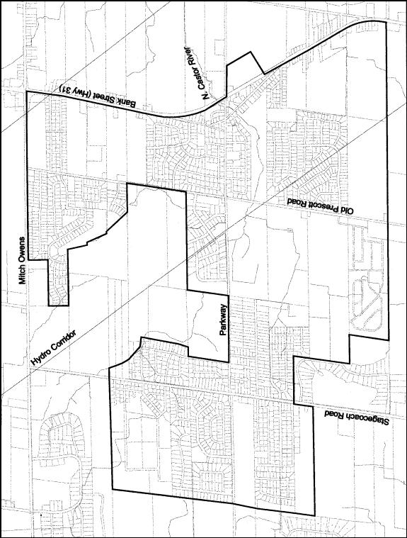
Located in the former Township of Osgoode, Greely is
the largest rural village in Ottawa in terms of land area with approximately
1,050 hectares of land within its boundaries and the third largest in terms of
population with approximately 4,150 people (Document 1). Historically Greely was two separate
villages from a planning perspective: Greely, centered along Parkway Road west
of Highway 31, and Greely West, centered along Parkway Road and Stagecoach
Road. Several boundary expansions
throughout the 1980s and 1990s combined the two villages by adding the lands
in-between and surrounding the villages.
Presently approximately 55% of the land with Greely's boundaries is
developed, the vast majority of which is for single detached dwellings.
Greely has been the fastest growing rural
village in Ottawa over the last thirty years, attributable primarily to its
proximity to the City's urban areas combined with the draw of its rural
atmosphere. Based on the supply of land
designated Residential and current development trends, approximately 1,900 new
dwelling units could potentially be constructed in Greely. This represents a potential doubling of the
current total number of dwelling units in Greely.
A host of planning issues make Greely atypical
of other rural villages in Ottawa.
These issues include the Greely's boundary evolution and the large areas
of vacant land within the centre of the village; the absence of a "main
street" containing a concentration of commercial and service uses; the
presence of several rural estate developments adjacent to the village's
boundary; the presence of an industrial park in the centre of the village; and
residents identifying more with individual subdivisions than the community as a
whole.
The Planning and Growth Management Department
initiated the Greely Land Use and Design Study (Greely LUDS) in February 2003
to address these issues by developing a comprehensive land use vision and
plan. FoTenn Consultants Inc. was
retained by the City to undertake the Greely LUDS, the process and timeline of
which is detailed in Document 2. The
Study's final report in May 2004 included four main components: key principles
for future growth and development; a village land use plan and land use
policies; village core design recommendations; and suggested tools for
implementation.
The Council-adopted Official Plan states that City Council will approve community design plans as land use policy plans to replace the existing village plans in Volume 2C of the Official Plan. The Planning and Growth Management Department prepared a Greely Community Design Plan (Greely CDP) based on the recommendations of the Greely LUDS. The proposed Official Plan Amendments would remove the policies and schedules in the Council-adopted Official Plan and Official Plan of the former Township of Osgoode as they relate to Greely and would add the Greely Community Design Plan to the Council-adopted Official Plan.
DISCUSSION
The Planning and Growth Management Department
prepared the Greely CDP based on the recommendations of the Greely LUDS' final
report. These recommendations were revised and enhanced where necessary to fit
them into the policy framework of a Community Design Plan and to account for
new information that became available after completion of the final
report. The Greely CDP, distributed
under separate cover, is comprised of the following seven components:
(1)
Community Vision
This section highlights the public consultation process of the Greely
LUDS and discusses the vision statement developed by participants at the
visioning workshop. Five key principles
were developed from the vision statement and the directions of the Official Plan and were the foundation
when developing the recommended land use plan. The five development principles
are:
Principle 1: Open Space and Recreation - develop a greenspace system that integrates all recreational and environmental areas of the Village.
Principle 2: Linkages - provide an interconnected system of walkways, trails and roads to connect different areas of the Village.
Principle 3: Sustainability - ensure that all future development does not adversely impact the Village's water resources.
Principle 4: Diversity and Community Character - provide a range of housing types and commercial opportunities while maintaining the rural atmosphere.
Principle 5: Mobility - provide an interconnected transportation system maintaining and enhancing accessibility.
(2)
Growth Management Strategy
This section identifies how all future growth
and development in Greely will be accommodated in order to promote the
sustainable development of the Village. This section is comprised of three
subsections:
Village Boundary:
Describes how Greely's village
boundary will be evaluated in the future and how development applications
adjacent to the boundary will be reviewed.
Environmental
Protection:
Describes the subwatershed study,
the drainage study and the hydrogeological characterization study undertaken
concurrently with the Greely LUDS. The
Greely CDP incorporates these studies' recommendations wherever possible.
Servicing:
Identifies that all future
development in Greely will be serviced by individual private water supply and
sanitary sewer systems, with the exception of subdivisions with previous
approvals for communal systems.
(3)
Land Use Plan
This section describes the land use plan that
will guide Greely's future development.
There are nine land use designations within the Greely CDP, five of
which are existing designations with the majority of existing policies intact
and four of which are new designations
which reflect the recommendations of the Subwatershed Study or the direction of the Official Plan. The designations are:
1. Residential
2. Village
Core
3. Shopping
Centre Commercial
4. Highway
Commercial
5. Industrial
6. Open
Space
7. Provincially
Significant Wetland
8. Ecological
Feature
9. Ecolological
Function
(4)
Village Core Plan
This section provides design guidelines that
promote the development of a unique identity
for Greely's Village Core. The design
guidelines are meant to be a guide to development within Greely's Core during
the development review process and are divided into four themes.
Built Form
Guidelines:
Promote a built form that promotes a
variety of uses and variety of forms in the Core, gives the Core a distinct
identity, and that works well with the streetscape.
Streetscape
Guidelines:
Promote streetscapes in the Core
that are safe and allow ease of movement for pedestrians, are linked to
surrounding neighbourhoods, and creates
an intimate and visually appealing public atmosphere.
Gateway
and Edge Guidelines:
Promote key gateway and edges in
the Core that are visually appealing and provide a positive image of Greely.
Key
Development Site Guidelines:
Provide further, site-specific
direction to three presently vacant sites within the Core that offer an
excellent opportunity for showcasing the guidelines.
(5)
Road Network
This section describes Greely's road network,
which is intended to accommodate all transportation types while keeping safety
and accessibility in mind. The road
network plan shows all existing arterial, collector and local roads together
with the conceptual future collector, conceptual future local road patterns,
and future road connections to areas adjacent to the village boundary. The policies for the road network plan
include right-of-way requirements, sidewalk requirements, and connection
requirements for lands adjacent to the village boundary.
(6)
Greenspace Network
This section provides the strategy for Greely's
greenspace network, which includes existing parks, future parks, walkways and
trails, and environmental areas.
Greenspace in Greely is to be well-distributed, accessible,
interconnected and varied in type and function. The greenspace network plan shows all existing parks together
with conceptual future park locations and identified environmental areas. The policies
for the greenspace system describe methods of acquisition of future parkland,
general requirements for future parks, consideration for public walkways, study
requirements for environmental areas, considerations for public walkways and
trails, and connection requirements for lands adjacent to the village boundary.
(7)
Implementation Strategy
This section identifies the strategy for
implementing the Greely CDP by establishing how the plan will be interpreted,
implemented and monitored. For
interpretation, the elements of this Plan are flexible as long the general
intent of the Plan’s policies is maintained.
For implementation, the specific action steps to be accomplished and
participants involved are identified.
For monitoring, the timing and criteria for evaluating the CDP in the
future following approval are identified.
The proposed Official Plan Amendments, detailed
in Document 3, would be the first action step for implementing the Greely
CDP. Official Plan Amendment No.X will
remove the Greely Village Plan from Volume 2C of the Council-adopted Official
Plan and will add the Greely CDP to Annex 5 in Volume 1 of the Council-adopted
Official Plan; Official Plan Amendment No.XX would remove the policies and
schedule from the Official Plan of the former Township of Osgoode as they
relate to Greely.
Additionally, staff are seeking Council's direction, following approval of the CDP, to bring forward a zoning by-amendment to implement the recommendations of the Greely CDP regarding reductions to the physical size of the Village Core to provide a clearer focus and to limit potential land use conflicts. The Zoning By-law Amendment would rezone 95 properties from Village Community (V) to Residential (R), to match the zoning on the existing established residential neighbourhoods surrounding the Core. A draft version of this zoning by-law amendment is detailed in Document 4.
ENVIRONMENTAL IMPLICATIONS
Three other studies for Greely and the surrounding
area were undertaken concurrently with the Greely LUDS: the Shields Creek
Subwatershed Study, the Greely/Shields Creek Stormwater and Drainage Study, and
the Greely Hydrogeological Characterization Study. Wherever possible the recommendations of these three studies have
been incorporated into the Greely CDP, which include:
- Creek corridors
for Shields Creek and its tributaries;
- Drainage
guidelines;
- Requirements for
hydrogeological and terrain analysis evaluations;
- Two new
designations to protect an interior woodland habitat; and
- Riparian plantings along Shields Creek within Andy Shields Park.
The study area of the Greely LUDS and Greely CDP only
includes the lands within the current village boundary, as defined by Schedule
A of the Official Plan. An expansion of
the village boundary for Greely was not considered through the Greely LUDS
given the current adequate supply of developable residential lands within
Greely. The surrounding rural areas
adjacent to the village boundary were considered in terms of road and trail
connections. Additionally, the rural
area surrounding the Village of Greely was considered during the Subwatershed
Study, which studied the lands within the village together with the surrounding
area.
The Ontario Municipal Board issued a partial order on November 1, 2004 concerning an Official Plan Amendment, Zoning By-law Amendment, and Subdivision Approval regarding lands within the "hole in the donut", the lands within the "centre" of the Village but outside of the village boundary. The order was partial in that the Official Plan Amendment to include the lands within the boundary was allowed, but time was given for the parties to finalize the subdivision details prior to approval. Once these details are finalized, the subdivision will be added to the Greely CDP schedules by staff.
CONSULTATION
A Steering Committee was initiated at the beginning
of the Greely LUDS with representatives from the Approvals Branch and the
Policy Branch of the Planning and Growth Management Department and
representatives from the South Nation Conservation Authority. Five Steering Committee meetings were held
throughout the study's duration to collect input from the representatives.
As per the direction of the Official Plan, the Greely LUDS employed
an open and collaborative process for public consultation, as detailed in
Document 2. Four public consultation
sessions were held to gain input and feedback from the public: three sessions
with the general public and one session with landowners owning large areas of
undeveloped land. These four session
are described below.
The first session on April 15, 2003 was a facilitated workshop with
the purpose of establishing a vision and set of development principles based on
the values expressed by the public.
Approximately 150 people attended the workshop.
The second session on June 11, 2003
was a meeting to present the two land use concept plan alternatives to
all landowners who own large parcels of undeveloped land. Approximately 35 people attended the
meeting, including landowners, their agents and City staff. The feedback received at this meeting
revised the alternative land use concept plans prior to their presentation at
the public session on June 26, 2003.
The third session on June 26, 2003 was an open house held jointly
with the Shields Creek Subwatershed Study with the purpose of presenting and
receiving feedback on the two land use concept alternatives and the Shield’s
Creek Subwatershed draft management strategy.
Approximately 50 people attended the open house.
The fourth session on March 11, 2004 was an open house held jointly
with the Shields Creek Subwatershed Study, with the purpose of presenting the
draft recommended land use plan and
supporting policies and the Shield’s Creek Subwatershed management
recommendations and implementation strategy.
Approximately 60 people attended the open house.
Residents and landowners were notified of the public sessions and
updated on the Study’s progress through a combination of notices in community
newspapers, flyer mail outs, invitations through the Study’s mailing list, and
notices on the City’s public consultation website. Copies of the draft report and final report for the Greely LUDS
and the draft report of the Greely
Community Design Plan have been held for public review at the Greely Public
Library throughout the process.
Several comments from the public were submitted throughout the
process. A summary of the common
comments and how the CDP addresses them is provided in Document 5.
Councillor Thompson has been involved throughout both the Greely LUDS and Greely CDP processes.
FINANCIAL
IMPLICATIONS
SUPPORTING
DOCUMENTATION
Document 1 Village
of Greely Location Map
Document 2 Greely
LUDS timeline
Document 3 Proposed
Official Plan Amendments
Document 4 Draft
Zoning By-law Amendment
Document
5 Summary of Public Comments
Document 6 Greely Community Design Plan (under separate cover and on file with the City Clerk)
DISPOSITION
1. The
Planning and Growth Management Department will issue the Notice of Decision
within the 20 day appeal period for Ottawa Official Plan Amendments X and XX.
2. The Planning and Growth Management Department will revise Annex 5 to the Official Plan to indicate that Greely is subject to a Community Design Plan, replacing the reference to a Village Plan.
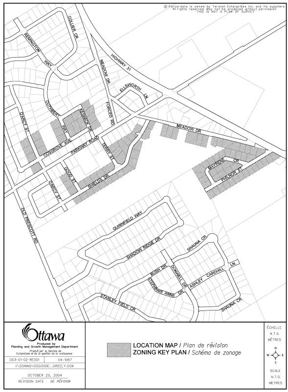
GREELY
LUDS – PROCESS AND TIMELINE Document 2
# |
Step |
Date |
1 |
Preparation of detailed work program and work schedule |
February 2003 |
2 |
Steering Committee meeting #1 – study initiation |
February 20, 2003 |
3 |
Compilation, review and analysis of background information |
February – March 2003 |
4 |
Steering Committee meeting #2 – review of background information and workshop preparation |
March 18, 2003 |
5 |
Workshop – Visioning and development principles |
April 15, 2003 |
6 |
Preparation of “existing conditions report” |
May 2003 |
7 |
Steering Committee meeting #3 – review of “existing conditions report” and initiation of concept plan alternatives |
May 2, 2003 |
8 |
Steering Committee meeting #4 – review of concept plan alternatives and open house preparation |
June 5, 2003 |
9 |
Landowner meeting – review of alternative concept plans |
June 11, 2003 |
10 |
Open House #1 – review of alternative concept plans |
June 26, 2003 |
- |
Study put on hold pending the completion of the Greely Groundwater Modelling study |
July – December 2003 |
11 |
Preparation of draft report |
January – February 2004 |
12 |
Steering Committee meeting #5 – review of draft report |
February 25, 2004 |
13 |
Open House #2 – review of preferred concept plan and draft report |
March 11, 2004 |
14 |
Preparation of preferred concept plan final report |
March – April 2004 |
15 |
Submission of final preferred report |
May 2004 |
1. OFFICIAL
PLAN AMENDMENT NO. ___ TO THE OFFICIAL PLAN FOR THE FORMER TOWNSHIP OF OSGOODE.
2. OFFICIAL PLAN AMENDMENT
NO. ___ TO THE OFFICIAL PLAN (2003) OF THE CITY OF OTTAWA.
INDEX
Page
THE STATEMENT OF COMPONENTS i
PART A - THE PREAMBLE
1.0 Purpose 1
2.0 Location 1
3.0 Basis 1
PART B - THE AMENDMENT
1.0 Introduction 2
2.0 Details 2
3.0 Implementation 3
THE STATEMENT OF
COMPONENTS
Part A - The Preamble
introduces but does not constitue part of these Amendments.
Part B - The Amendments,
consisting of text, constitute individual amendments to the listed Official
Plans below:
Amendment No. ___ to the Official Plan for the former
Township of Osgoode
Amendment No. ___ to the Official Plan (2003) of the City
of Ottawa.
PART A - THE PREAMBLE
1.0 Purpose
The purpose of the Amendment is to adopt the
Greely Community Design Plan which will be the new
policy plan directing future land use planning decisions in the Village of
Greely. The Amendment removes the policies and
schedule as they relate to Greely in the Official Plan (2003) of the City of
Ottawa and the Official Plan for the former Township of Osgoode, and adds the
Greely Community Design Plan to the Official Plan (2003) of the City of Ottawa
and the Official Plan.
2.0 Location
The Amendment affects all of the land within the Village of Greely,
as defined on Schedule A of the Official Plan.
3.0 Basis
The City of Ottawa initiated the Greely Land Use and Design Study in February 2003 with the objective of developing a comprehensive and coordinated land use and design vision for the Village of Greely. The Study was necessitated by several land use planning issues in Greely, such as the potential for the village’s population to double in the next twenty years; the continuation of rural estate development surrounding the Village; the continual development of unconnected residential subdivisions within the Village; and the lack of an established “main street”.
The Land Use and Design Study final report, which was completed in May 2004, recommended development principles to be considered during the development review process; more detailed land use policy direction for existing land use designations; new land use designations and policies for the environmental areas identified by the Shield’s Creek Subwatershed Study; design suggestions for the community core; and suggested tools for implementation.
The Official Plan (Section
2.5.7) states that Council will approve community design plans as policy documents
to guide future development, replacing village plans that existed prior to the
formation of the new City of Ottawa and that are currently held in Volume 2C of
the Official Plan. City staff prepared
a Greely CDP, based on the recommendations of the Greely Land Use and Design
Study, which will replace the existing Greely Village Plan.
1.0 Introduction
All of this part of this document entitled Part B - The Amendment, consisting of the following text, constitutes Amendment No. ___ to the Official Plan of the former Township of Osgoode and constitutes Amendment No. ___ to the Official Plan (2003) of the City of Ottawa.
2.0 Details
The following changes are hereby made to the
Official Plan for the former Township of Osgoode:
(1) Map 2 of Schedule A is removed;
(2) “(Map 2 to Map 7)” in the first paragraph of Section 3.17.5 is changed to “(Map 3 to Map 7)”.
(3) The third and fourth sentences of Section 2.2.5 are removed;
(4) The last sentence of the fifth paragraph of Section 3.17.5 is removed;
(5) Section 3.12.1.6 is removed in its entirety;
(6) The second sentence of Section 3.12.3.1 is removed;
(7) Section 4.1.4 is removed in its entirety;
(8) Section 4.2 is removed in its entirety;
(9) Section 4.7.4 is removed in its entirety;
(10) Section 4.10.4 is removed in its entirety;
(11) Section 4.11.4 is removed in its entirety; and
(12)
Section 4.12.4 is removed in its
entirety.
The following changes are hereby made to Volume
1 of the Official Plan (2003) of the City of Ottawa:
(1) The
legend reference and corresponding colour on Annex 5 for the Village of Greely
is changed from “Village Plan” to “Community Design Plan”.
The following changes are hereby made to Volume
2C of the Official Plan (2003) of the City of Ottawa:
(1) Map 2 of Schedule A is removed;
(2) “(Map 2 to Map 7)” in the first paragraph of Section 3.17.5 is changed to “(Map 3 to Map 7)”.
(3) “Greely” in the title of the section for the former Township of Osgoode Village Plans is removed so that it reads “Kenmore, Marionville, Metcalfe, Osgoode, Vernon”;
(4) The last sentence of the fifth paragraph of Section 3.17.5 is removed;
(5) Section 4.1.4 is removed in its entirety;
(6) Section 4.2 is removed in its entirety;
(7) Section 4.7.4 is removed in its entirety;
(8) Section 4.10.4 is removed in its entirety;
(9) Section 4.11.4 is
removed in its entirety; and
(10)
Section 4.12.4 is removed in its
entirety.
3.0 Implementation
The implementation of these Amendments shall be in accordance with the
respective policies of the Official Plan for the former Township of Osgoode and
the Official Plan (2003) of the City of Ottawa.
Explanatory Note:
By-law Number _____ amends Zoning By-law 2003-230, the zoning by-law of the former Township of Osgoode, in order to implement the recommendations of the Greely Community Design Plan. This change results from the recommendations of the Greely Community Design Plan to reduce the physical size of the existing Village Core designation in order to limit any potential future land use conflicts within the surrounding established residential areas and to provide a clearer focus for the Core.
The Amendment affects properties within the existing Village Core, the location and municipal addresses of which are identified in Document 1. The Amendment changes the zoning on all of these properties from Village Community (V) to Residential (R), to reflect the zoning in the surrounding established residential areas.
Details of
Zoning Amendment:
The zoning
amendment will change the zoning of the 95 properties shown on Document 1 from
Village Community (V) to Residential (R).
The first part of By-law Number _____ affects the municipal addresses listed in the below table, by changing their zoning from Village Community (V) to Residential (R).
1. |
6126 Bank Street |
33. |
1504 Mayrene Crescent |
65. |
7228 Philnor Street |
|
2. |
7019 Cosgrove Avenue |
34. |
1505 Mayrene Crescent |
66. |
7234 Philnor Street |
|
3. |
7065 Cosgrove Avenue |
35. |
1509 Mayrene Crescent |
67. |
7235 Philnor Street |
|
4. |
1368 Cuthbert Way |
36. |
1513 Mayrene Crescent |
68. |
7240 Philnor Street |
|
5. |
1371 Cuthbert Way |
37. |
1517 Mayrene Crescent |
69. |
7246 Philnor Street |
|
6. |
1376 Cuthbert Way |
38. |
1521 Mayrene Crescent |
70. |
7249 Philnor Street |
|
7. |
1384 Cuthbert Way |
39. |
1422 Meadow Drive |
71. |
7250 Philnor Street |
|
8. |
1385 Cuthbert Way |
40. |
1434 Meadow Drive |
72. |
7038 Shields Drive |
|
9. |
1366 D’Arcy Street |
41. |
1438 Meadow Drive |
73. |
7048 Shields Drive |
|
10. |
1367 D’Arcy Street |
42. |
1442 Meadow Drive |
74. |
7051Shields Drive |
|
11. |
1374 D’Arcy Street |
43. |
1456 Meadow Drive |
75. |
7052 Shields Drive |
|
12. |
1375 D’Arcy Street |
44. |
1460 Meadow Drive |
76. |
7055 Shields Drive |
|
13. |
1422 Good Street |
45. |
1464 Meadow Drive |
77. |
7062 Shields Drive |
|
14. |
1432 Good Street |
46. |
1476 Meadow Drive |
78. |
7063Shields Drive |
|
15. |
1440 Good Street |
47. |
1480 Meadow Drive |
79. |
7070 Shields Drive |
|
16. |
1389 Johnston Drive |
48. |
1484 Meadow Drive |
80. |
7071 Shields Drive |
|
17. |
1400 Johnston Drive |
49. |
1494 Meadow Drive |
81. |
7078 Shields Drive |
|
18. |
1369 Keswick Drive |
50. |
1498 Meadow Drive |
82. |
7079 Shields Drive |
|
19. |
1372 Keswick Drive |
51. |
1502 Meadow Drive |
83. |
7086 Shields Drive |
|
20. |
1375 Keswick Drive |
52. |
1508 Meadow Drive |
84. |
7094 Shields Drive |
|
21. |
1380 Keswick Drive |
53. |
7186 Philnor Street |
85. |
7097 Shields Drive |
|
22. |
1383 Keswick Drive |
54. |
7192 Philnor Street |
86. |
7102 Shields Drive |
|
23. |
1391 Keswick Drive |
55. |
7196 Philnor Street |
87. |
7110 Shields Drive |
|
24. |
1477 Mayrene Crescent |
56. |
7197 Philnor Street |
88. |
7111 Shields Drive |
|
25. |
1481 Mayrene Crescent |
57. |
7200 Philnor Street |
89. |
7118 Shields Drive |
|
26. |
1485 Mayrene Crescent |
58. |
7203 Philnor Street |
90. |
7119 Shields Drive |
|
27. |
1489 Mayrene Crescent |
59. |
7204 Philnor Street |
91. |
7124 Shields Drive |
|
28. |
1492 Mayrene Crescent |
60. |
7207 Philnor Street |
92. |
7125 Shields Drive |
|
29. |
1493 Mayrene Crescent |
61. |
7210 Philnor Street |
93. |
7130 Shields Drive |
|
30. |
1497 Mayrene Crescent |
62. |
7211 Philnor Street |
94. |
1423 Terry Street |
|
31. |
1498 Mayrene Crescent |
63. |
7216 Philnor Street |
95. |
1429 Terry Street |
|
32. |
1501 Mayrene Crescent |
64. |
7222 Philnor Street |
|
|
|
Comment: Bigger lots sizes are consistent with existing
development pattern and the country atmosphere
Response: All lot sizes for new residential subdivisions will be determined by the
hydrogeological evaluations that are required as part of the development review
process. It is anticipated by staff lot
sizes for new residential subdivisions will be required to be greater than 0.2
hectares (0.5 acres) as a result of these hydrogeological evaluations.
Comment: Development should be based on private, individual water and septic systems and not central or communal systems
Response: The Greely CDP’s land use plan is based on all future development being
serviced by private, individual water supply and sanitary sewer systems, with
the exception of Shadow Ridge Estates, a subdivision that has a previous
approval for a communal water supply and sanitary sewer system.
Comment: There
should not be road access to Misty Morning Drive or Lakeshore Drive from
abutting, currently undeveloped properties
Response: The Council-adopted Official Plan promotes a modified grid network of
roads for new subdivisions, in order to enable accessibility and permeability
of movement. This was incorporated into
the road network of the Greely LUDS, which was reviewed by the consulting team
and City staff and was deemed to be adequate and appropriate. While the local road network plan in the
Greely CDP is conceptual and is flexible to site-specific features and
conditions during the subdivision review process, the general intent of the
overall road network such as key road connections and permeability must be
adhered to. Development applications
for these abutting developments will be reviewed during the subdivision review
process, which will again include considerations for traffic impacts.
Comment: Provide
for a more defined central focus for the village with good connections to
residential areas
Response: The Village Core Plan in the Greely CDP provides more detailed direction
for Greely’s village core, through design guidelines that address building
form, streetscapes, gateways and edges, and key development sites. The Village Core designation was reduced in
the Greely CDP, from that of the previous Greely Village Plan, to provide a
clearer focus along the Core’s main streets while lessening any potential land
use conflicts in the surrounding established residential neighbourhoods.
Comment: The
environmental impact of development must be recognized
Response: The City has undertaken several studies regarding the natural systems,
drainage systems and groundwater systems in Greely and the surrounding areas
between 2002 and 2004. The Greely CDP
has included the recommendations of these studies, wherever possible, such as
the preservation of significant ecological areas through the land use plan or
the protection of the groundwater resources through hydrogeological evaluations
during the development approval process.
Comment: Commercial
activity at the Mitch Owens Drive and Albion Road intersection best serves the
community
Response: The intersection of Mitch Owens Drive and Albion Road is currently
outside of the village boundary. This
intersection is presently oriented to the passing vehicular traffic with very
limited retail commercial uses. This
conforms to the intentions of the Greely CDP which intends to focus retail
commercial uses within the existing Village Core while directing
automobile-related uses to such intersections.
Comment: No
higher density housing should be allowed in Greely
Response: The Council-adopted Official Plan intends that villages should contain a
“wide range of housing form to meet the needs of the Village’s population”. The
Greely CDP recognizes that Greely is and will continue to develop as a
community of primarily low-density housing.
The Greely CDP does permit two-unit and ground oriented multi-unit
dwellings, and apartment units within the Village Core, and two-unit and ground
oriented multi-unit dwellings on a limited basis in the Residential
designation, subject to a list of conditions.
All multiple unit development is constrained by hydrogeological
conditions within Greely, as highlighted in the responses above regarding lot
sizes and servicing.
Comment: Parkway
Road is dangerous and should be improved
Response: The Greely CDP suggests in the Implementation Strategy in Section 8,
that the current “rural cross-section” for Parkway Road, and other main streets
in Greely, be reviewed and possibly switched to a “village cross-section” that
is more pedestrian and cyclist friendly.
Comment: Development
must take into consideration the preservation of existing ponds and lakes in
existing developments
Response: These considerations will be part of the development review process for
adjacent properties to ensure the preservation of existing ponds and lakes.
Comment: Private
parks and private trails in the Sunset Lakes neighbourhood are shown
incorrectly on the Greenspace Network Plan
Response: To eliminate any confusion, no linkages, public or private, have been
shown on the Greenspace Network Plan in the Sunset Lakes neighbourhood. The private parks within the Sunset Lakes
neighbourhood are clearly identified as “Private Open Space” on the Greenspace
Network Plan.
Comment: Certain
roads within Greely have been incorrectly designated as collector roads
Response: The Greely LUDS took direction regarding the road network from Schedule
H of the Official Plan. As part of the
new Official Plan process, a common set of criteria was applied to all roads in
the City to develop a single road hierarchy classification system. The roads in question, meeting these
criteria, were designated as collector roads.
Essentially, these roads are local roads that perform collector function
within the local neighbourhood. The Official Plan does permit the redesignation
of collector roads as part of a Community Design Plan process without
Amendment. To reduce any confusion, given that these roads in question were
designed with a local road standard (20.0 metre R.O.W.), these roads have been
changed back to a local roads classification.
GREELY
COMMUNITY DESIGN PLAN - OFFICIAL PLAN AMENDMENT
PLAN DE CONCEPTION COMMUNAUTAIRE DE GREELY - MODIFICATION DU PLAN
OFFICIEL
ACS2004-DEV-pol-0038
Chair Hume began by reading a statement required under the Planning Act, which advised that anyone who intended to appeal this proposed Official Plan Amendment to the Ontario Municipal Board (OMB), must either voice their objections at the public meeting, or submit their comments in writing prior to the amendment being adopted by City Council. Failure to do so could result in refusal/dismissal of the appeal by the OMB.
The Committee agreed with a suggestion from Chair Peter Hume, further to
a staff request, to deal with Items 3 and 21 concurrently.
Ms. Susan Murphy, Planner, Environmental Management Division, presented the report on Item 21, Shields
Creek Subwatershed Plan. She described
the four Phases of the study, the management strategy being recommended and the
public consultation process that included a Steering Committee and a series of
open houses for interested community members.
A copy of Ms. Murphy’s PowerPoint presentation is on file with the
Coordinator.
Ms. Pamela Sweet, FoTenn Consultants Inc, provided information on the Greely Land Use
and Design Study (LUDS). She noted that
the Vision that Greely residents want to maintain is that of a village setting,
with increased opportunities to improve on what they believe is missing. The vision has been refined to the following
five principles:
·
Open space and
recreation – integration of all recreational and environmental areas of the
Village;
·
Linkages – the
provision of walkways, trails, roads to connect different parts of the Village;
·
Sustainability
– ensuring that all future development does not negatively impact water
resources;
·
Diversity and
community character – requirement for a range of housing types and commercial
opportunities while maintaining and enhancing accessibility;
·
Mobility – need
for an interconnected transportation system maintaining and enhancing
accessibility.
Mr. Kevin Muir, Planner, Community Planning and Design Division, provided additional information related to
the land use plan that will guide Greely’s future development and he fleshed
out the amendments to the former Ottawa and Osgoode Official Plans. Mr. Muir focused the Committee’s attention
on a number of minor amendments to the Community Design Plan for the Village of
Greely, resulting from an Ontario Municipal Board approval of November 1, 2004.
The Committee then heard from the following delegations:
Andrew Wilson, Sunset Lakes Owner’s Association, said the community has specific concerns
regarding Schedule C, Village Road Network Plan and the proposed linkages shown
by way of “arrows”. The community makes
significant use of a recreation area that is less than 200 meters from where
proposed linkages exist and there are concerns with vehicle traffic, including
significant truck traffic on Mitch Owens Road.
The Association has suggested that traffic flow out of a proposed
subdivision to the south, in an east-west direction and believe a safer access
route would be west to Stagecoach in a northerly direction, or east to Old
Prescott, since these roads are designed to accommodate heavy traffic. Mr. Wilson felt that retaining the linkage,
which City staff feel is necessary, is prejudging something that requires
further study.
At this point, Councillor Herb Kreling presented a Motion on behalf of
the ward Councillor, Doug Thompson, calling for the indicator “arrows” to be
removed from the Greely Community Design Plan.
Mr. Graham Fawcett, a resident of Greely West Community felt that the study area was too exclusionary
and limited in scope. By way of
example, he cited the exclusion of a large wrecking yard almost in the centre
of the village, calling it a serious flaw to exclude this facility from any
hydro-geological studies. Also excluded
is a large tire recycling facility, which is of so much concern to Ottawa Fire
Services that it has in place an evacuation plan for the entire area. Mr. Fawcett also felt that excluding the
retirement community of Albion Sun Vista and its 225 residents made no
sense. He expressed the hope that the
definition and the scope of the study could be enlarged to address his
concerns.
Mr. Gordon McCormick,
a resident of Shadow Ridge community, suggested there needed to be a traffic
impact study within the Greely Development Plan, especially as it impacts on
two developments planned for the west side of Old Prescott Road near
Parkway. He also felt the Plan should
contain a statement about whether or not mass transit services would be brought
to the area. A copy of his written
submission is on file with the Coordinator.
Mr. Jack Cadieux is
the owner of the east part of Lot 8, Concession IV, Greely, approximately 155
acres bordering on Shadow Ridge Estates, and on the Quinn Farm to the
north. He expressed concern about the
consultation around the Greely Community Design Plan, pointing out that, even
if this is a direct outgrowth of the Greely LUDS, there are some important
differences. He also referred to the
fact that he was not informed about the Committee’s discussion on a communal
well on a property to the south of his holdings and that he had only two
working days to prepare his comments in response to the extensive amendments to
the Osgoode and Ottawa Official Plans.
He requested that the Committee place a rider on the approval of these
amendments until such time as he and his counsel can review them to see how he
will be impacted.
In his written submission, Mr. Cadieux presents the findings of an
analysis he did of communities in Ontario with populations of between eight and
ten thousand residents and what they had by way of municipal water and
wastewater systems. He felt very strongly
that the Greely Design Plan should address at what point the City envisions
municipal water or wastewater systems being required because of the size and
the population of the Village. He also
alluded to Schedule 1 of Osgoode Official Plan X, which stipulated that a
significant extent of residential area slated for medium and high density
residential development would be based on communal water and wastewater systems
for Shadow Ridge Estates. He concluded
by asking that reference be made to his holdings any time the Shadow Ridge
Estates are mentioned and also that it be stated that references to collector
and local roads are conceptual in nature and subject to change.
Dave Krajaefski, representing Landriault Construction, noted that the company has an interest in
the approval of the Greely Community Design Plan (CDP) and support the report
recommendations. The CDP provides for
the southerly extension of Lakes Park Drive, across the proposed Landriault
subdivision, to connect ultimately to Old Prescott Road and Schedule C provides
for the connection of the Landriault subdivision to Lakes Park Drive. Mr. Krajaefski called the proposed extension
of Lakes Park Drive absolutely essential to the Landriault development and to
the properties immediately to the north.
Without this connection, future residents would be living on a dead end
road with only on way in and out to the south to Old Prescott Road. He expressed the view that to limit public
road access to only one street, when a second access is the width of a one-foot
reserve away, was not good land use planning.
The principle of serving the public interest extends beyond the limit of
the Landriault subdivision. The
adjacent subdivision to the north, Sunset Lakes, places Lakes Park Drive as a
registered and open road allowance adjacent to the Landriault property. It should be noted that the former Township
of Osgoode also recognized the importance of the provision of a future
connection. For all these reasons, Landriault
Construction supports the staff recommendations and the Greely Development
Plan.
Paul Webber, expressed
strong support for the amendments presented by staff early in the presentation,
as well as the position outlined by the Sunset Lakes Community Association
about using the subdivision process and the traffic impact studies to determine
whether or not to open roads. Mr.
Webber noted that, while he supports the Shields Creek Watershed Study, there
are concerns about process but these are being addressed by staff. Speaking to the status of the CDP, Mr.
Webber said the section of the Official Plan that defines community design has
been repealed and is being replaced by another section that also has no
approval. Staff have indicated that the
Greely Design Plan is not a planning document therefore it cannot be appealed,
nor is it a policy that the OMB would consider itself bound to follow: on this
basis, it can be supported. Mr. Webber
emphasized that the Official Plan issue must be resolved, so everyone
understands what a community design plan is.
Tim Chadder,
representing Mr. Gordon, the owner of 200 acres at the centre of the village,
said that, based on the amendments that staff have introduced, he concurred
with the overall approach in the development of Greely.
At this point, Chair Hume closed the public meeting and returned the
matter to Committee.
The Committee first considered the following technical amendment to Item
21, on a Motion from Councillor A. Cullen:
That
the Planning and Environment Committee recommend Council approve, in principle,
the Shields Creek Subwatershed Study, Final Report 2, as amended by the
following:
WHEREAS
comments were received regarding the Shields Creek Subwatershed Study following
the printing of the final report for the Planning and Environment Committee;
AND
WHEREAS resolution of these comments is possible through minor amendment to the
final report that is in keeping with the intent of the Subwatershed Plan;
THEREFORE BE IT RESOLVED
that the Guidelines for Site Specific Hydrogeological Studies contained within
Appendix O of the Shields Creek Subwatershed Study Final Report and
corresponding text (page 5-6) be removed.
CARRIED
as amended
Chair Hume then called for approval of the amendments put forward by City
staff:
WHEREAS
comments were received regarding the Greely Community Design Plan following the
printing of the document for the Planning and Environment Committee;
AND
WHEREAS resolution of these comments is possible through minor amendments to
the Community Design Plan that are in keeping with the intent of the Plan;
THEREFORE
BE IT RESOLVED that Recommendation 1 be revised to read:
3.
Approve the Community Design Plan for the Village of Greely as detailed in Document 6
(separate cover), as amended by the following changes:
a.
Revise all schedules, appendices and associated text within the
Greely Community Design Plan to reflect the decision of the Ontario Municipal
Board decision of November 1, 2004.
b.
Revise the first sentence of Policy (3)(b) to read:
“A 15-metre setback
from the high-water make along both sides of the tributary of Shields Creek, in
Concession IV, Lots 6 and 7, must be dedicated to the City as public open space
as part of the subdivision approval.”
c.
Remove Policy (5) of Section 7.2 in its entirety.
d.
Revise the last sentence in the “Permitted Uses” description of Section
4.2 to read:
“Given the hydrogeological conditions within
Greely, described in Section 3 of this CDP, it is anticipated that lot sizes
will be 0.2 hectares (0.5 acres) in size or greater.”
e.
Revise the second sentence of Section 8.1 to read:
“Many elements on the
schedules of this CDP are conceptual, including the specific pattern and
location of new collector and local roads; the specific size, configuration,
and location of community and neighbourhood parks; and the specific boundaries
of land use designations.”
f. Revise Poli\icy (3) of Section 6.4 to read:
“Proposed subdivisions
that are adjacent to the village boundary consider the local road connections
identified on Schedule C during the development review process, and are subject
to the requirements of a Traffic Impact Study.”
g.
Add Policy (8) to Section 4.2 that reads:
“Semi-detached and
townhouse dwellings are permitted to be concentrated within part of the lands
in Concession IV, Lot 8, based on a connection to the approved, ultimately
city-owned and operated, communal water supply and sanitary sewer systems for
the Shadow Ridge Estates subdivision, which is described in Section 3.4. In the event that studies required during
the subdivision approval process indicate that such a connection to this system
is not workable and/or economically viable, only low density residential uses
will be permitted.”
h.
Remove Policies (2) and (3) of Section 3.3 in their entirety.
i.
Revise Policy (1) of Section 3.3 to read:
“All development will give consideration to the recommendations of the Shields Creek Subwatershed Study, as they apply.”
AND
THEREFORE BE IT RESOLVED that new Recommendations 5 and 6 be added, which read:
5. Support a change in
the Village of Greely boundary on Schedule A of the Ottawa Official Plan (2003)
to include the lands subject to the Ontario Municipal Board Order dated Novmber
1, 2004.
6. Direct staff to
communicate this position to the Ontario Municipal Board at its pre-hearing on
June 6, 2005
CARRIED,
as amended
The Committee then approved the
report recommendations, with Recommendation 1 as amended by the foregoing,
and the addition of Recommendations 5 and 6.
2. Adopt Official Plan
Amendment No. X to the Official Plan (2003) of the City of Ottawa, as detailed
in Document 3, to remove the existing Greely Village Plan and to add the new
Greely Community Design Plan.
3. Adopt Official Plan
Amendment No. XX to the Official Plan of the former Township of Osgoode, as
detailed in Document 3, to remove the policies and schedule as they relate to
Village of Greely.
4. Direct Staff to bring forward at a
later meeting of the Planning and Environment Committee a zoning by-law
amendment, as detailed in Document 4, that implements in part the
recommendations of the Greely Community Design Plan.
And that no further
notice be provided pursuant to Section 34(17) of the Planning Act.
CARRIED
as amended
Speaking to the Motion presented by
Councillor Kreling, Councillor Doug Thompson praised staff for their
accessibility and flexibility. He noted
that the study has been going on for two years, and that he has held additional
consultations as well as hearing from the community with suggestions for
amendments. Greely is a fast-growing
community, with a number of significant developments still to come forward: the
village has a good mix of housing.
Councillor Thompson asked for the Committee’s support in removing from
the plan the “arrows” that show roadway and walkway linkages. He expressed the belief that, even though
this is a concept plan, inherent in the “arrows” is the concept of pre-judging
the best way for traffic to flow. The
Cycling Advisory Committee also wantsto be involved in developing bike paths:
these, along with roadways, are all intertwined. The Councillor did not believe he was derailing the development
of Greely by removing the arrows showing the proposed linkages. He stressed that the large majority of
residents, business people, builders and developers favour the development, and
their concerns about identifying linkages through traffic impact studies need
to be addressed.
The Director, Planning, Environment and
Infrastructure Policy, Mr. Dennis Jacobs, said he could agree that the removal
of the arrows would not derail the plan, but he expressed the belief it does
remove from the plan, a graphic representation of the comments made about the
need to ensure connections between the various parts of the community to be
studied as development occurs. He added
that the historical development pattern in Greely has been disconnected and he
stressed the importance of the principle that new development be integrated
from the point of view of transportation as well as pedestrian and cycling
access throughout the community.
Moved by Councillor H. Kreling
WHEREAS road linkages, road connections and walkway connections are
developed as part of Traffic-Impact Studies, and;
WHEREAS the Greely Community Design Plan indicates a wide variety of
possible road linkages and road connections, and walkway connections throughout
the Village, and;
WHEREAS these indicators may prejudge any future Traffic Impact
Study;
THEREFORE BE IT RESOLVED THAT these indicators (arrows) be removed
from the Greely Community Design Plan.
CARRIED with Councillors A. Cullen, D.
Holmes, P. Hume dissenting