Community Design Plan – (revised) Land Use Plan Document 2
1. Follow-up report: RIVERSIDE
SOUTH COMMUNITY DESIGN PLAN AND OFFICIAL PLAN AMENDMENTS - EARL ARMSTRONG
ROAD AT BOWESVILLE ROAD AND SPRATT ROAD RAPPORT DE SUIVI : PLAN DE CONCEPTION COMMUNAUTAIRE POUR RIVERSIDE-SUD ET
MODIFICATIONS DU PLAN OFFICIEL – CHEMIN EARL-ARMSTRONG À L'ANGLE DU CHEMIN
BOWESVILLE ET CHEMIN SPRATT |
Committee RECOMMENDATIONS AS AMENDED
That Council:
1. Approve the revised
Riverside South Community Design Plan as detailed in Document 1, subject to
the following amendments:
i)
That the majority of parking for the medium density (5-8 storeys) and
high density residential apartments be underground.
ii)
That at one-third build-out of the residential portion of the Riverside
South Community Design Plan, staff assess the progress achieved in meeting the
affordable housing component of the Plan and report to Planning and Environment
Committee.
iii)
That the first two paragraphs of Section 5.1 b) of the Site Plan
Guidelines be deleted in their entirety and be replaced with the following new
paragraph:
Parking requirements in the
Community Core should reflect the transit-oriented development approach. Reduced minimum and maximum parking ratios
for retail, office commercial and residential will be implemented at the time
of zoning in accordance with the new City of Ottawa Comprehensive Zoning By-law
for lands within the Core.
iv)
That the membership of the Design Review Committee be comprised of the
proponent, the Ward Councillor and the Deputy City Manager or their designates
until such time as Riverside South Community is covered by the broader City of
Ottawa Urban design process.
v)
That the last line of Section 2.3.3 “Commercial Sites” of the
Implementation Guideline be amended from “13,900” square metres to “15,300”
square metres of street-related retail.
vi)
That the social housing component of the Riverside South Community
Design Plan be at least 7% of residential units (i.e. affordable to the 20% of
household in Ottawa that are lower income), subject to federal/provincial
funding.
2. Approve and adopt an
amendment to the Official Plan of the City of Ottawa to redesignate land
located to the northwest and to the southwest of the intersection of Earl
Armstrong Road and Bowesville Road from "Employment Area" to
"General Urban Area", as detailed in Document 7.
3.
Approve and adopt an amendment to the Official Plan of the City of
Ottawa to redesignate land located west of Spratt Road from "General
Urban" to "Urban Natural Features", as detailed in Document 7.
RECOMMANDATION MOdifiées DU Comité
Que le Conseil :
1. Approuve
le Plan de conception communautaire pour Riverside-Sud, tel que le montre en
détail le document 1, sous réserve des modifications suivantes:
i)
Que la majorité des aires de stationnement des immeubles résidentiels à
moyenne densité (5 à 8 étages) et à haute densité soient souterraines.
ii)
Qu’au tiers de la construction de la portion résidentielle du plan de
conception communautaire de Riverside-Sud, le personnel évalue la situation de
la proportion de logements à prix abordables selon cette composante du plan et
qu’il fasse rapport aux membres du Comité de l’urbanisme et de l’environnement.
iii)
Que les deux premiers paragraphes de la section 5.1 b) des
lignes directrices du plan d’implantation soient retirés complètement et qu’ils
soient remplacés par le paragraphe suivant :
Les besoins en stationnement au cœur
du secteur devraient refléter l’approche de l’aménagement axé sur le transport
en commun. La réduction des ratios de stationnement minimaux et maximaux pour
les commerces de détail, les bureaux commerciaux et le secteur résidentiel sera
mise en place au moment du zonage, conformément au nouveau règlement général de
zonage de la Ville d’Ottawa pour les terrains dans le secteur.
iv)
Que le comité consultatif d’architecture soit constitué du promoteur de
projet, du conseiller de quartier et du directeur municipal adjoint ou leurs
mandataires jusqu’à ce que le secteur Riverside-Sud soit compris dans le
processus d’aménagement urbain plus vaste de la Ville d’Ottawa.
v)
Que la dernière ligne de la section 2.3.3 « Emplacements
commerciaux » des lignes directrices du plan de conception soit modifiées
quant à la surface allouée aux commerces au détail qui passe de
« 13 900 » mètres carrés à « 15 300 » mètres
carrés.
vi)
Que la composante du logement social du plan de conception communautaire
de Riverside-Sud soit constituée d’au moins 7 % des unités résidentielles
(c.‑à‑d. abordables pour les ménages à faible revenu qui
constituent 20 % des ménages à Ottawa), sous réserve du financement
fédéral et provincial.
2. Approuve
et adopte une modification du Plan officiel de la Ville d'Ottawa ayant pour
effet de changer de « Secteur d'emploi » à « Zone urbaine générale » la
désignation des terrains situés au nord-ouest et au sud-ouest de l'intersection
des chemins Earl-Armstrong et Bowesville, tel que le montre en détail le
document 7;
3. Approuve
et adopte une modification du Plan officiel de la Ville d'Ottawa ayant pour
effet de changer de « Zone urbaine générale » à « Caractéristiques
naturelles urbaines » la désignation des terrains situés à l'ouest du chemin
Spratt, tel que le montre en détail le document 7.
For the information of council
The Committee approved the following direction to staff:
That staff review the design
standards outlined in section 3.2.2 – Road Typologies to determine if
alternatives to the current standards, that would continue to meet the
transportation needs of the community, but would minimize the potential for
speeding and aggressive driving, reduce the need for sound barriers and encourage
pedestrian movement along the roadway can be used in Riverside South and that
staff report back when the core area urban design guidelines are presented to
Committee.
Le Comité a approuvé la directive
suivante :
The Committee approved the following direction to staff:
Que le personnel examine les normes
de conception soulignées à la section 3.2.2 – Types de route, dans le
but de déterminer si des options autres que les normes actuelles pourraient
être utilisées dans Riverside-Sud, tout en continuant de répondre aux besoins
en transport de la collectivité, en minimisant les possibilités de vitesse et
de conduite agressive, en réduisant le besoin d’y construire des murs du son et
en encourageant le mouvement piétonnier le long de la route. Le personnel fera
part de ses conclusions au Comité lorsque les lignes directrices de
l’aménagement urbain du secteur lui seront présentées.
Documentation
1. Deputy City Manager, Planning and Growth Management report dated 17 May 2005 (ACS2005-PGM-POL-0030).
2.
Extract of Draft
Minutes, 14 June 2005 will be distributed prior to Council.
Report to/Rapport au :
Planning and Environment Committee
Comité de l'urbanisme et de
l'environnement
and Council / et au Conseil
Submitted by/Soumis par : Ned Lathrop, Deputy City Manager/Directeur municipal adjoint,
Planning and Growth Management/Urbanisme et Gestion de la croissance
Contact Person/Personne ressource : Richard
Kilstrom,, Manager/Gestionnaire, Community
Planning and Design Division/Conception
communautaire, Planning, Environment and
Infrastructure Policy/Politiques d’urbanisme, d’environnement et
d’infrastructure
(613) 580-2424 x22653,
Richard.Kilstrom@Ottawa.ca
REPORT RECOMMENDATIONS
That the Planning and Environment Committee recommend:
1. That
Council approve the revised Riverside South Community Design Plan as detailed
in Document 1 and,
2. That
Council approve and adopt an amendment to the Official Plan of the City of
Ottawa to redesignate land located to the northwest and to the southwest of the
intersection of Earl Armstrong Road and Bowesville Road from "Employment
Area" to "General Urban Area", as detailed in Document 7.
3. That Council approve and adopt an amendment to the Official Plan of the City of Ottawa to redesignate land located west of Spratt Road from "General Urban" to "Urban Natural Features", as detailed in Document 7.
RECOMMANDATIONS DU
RAPPORT
Que le Comité de l'urbanisme et de
l'environnement recommande :
1. que
le Conseil approuve le Plan de conception communautaire pour Riverside-Sud, tel
que le montre en détail le document 1;
2. que
le Conseil approuve et adopte une modification du Plan officiel de la Ville
d'Ottawa ayant pour effet de changer de « Secteur d'emploi » à « Zone urbaine
générale » la désignation des terrains situés au nord-ouest et au sud-ouest de
l'intersection des chemins Earl-Armstrong et Bowesville, tel que le montre en
détail le document 7;
3. que
le Conseil approuve et adopte une modification du Plan officiel de la Ville
d'Ottawa ayant pour effet de changer de « Zone urbaine générale » à «
Caractéristiques naturelles urbaines » la désignation des terrains situés à
l'ouest du chemin Spratt, tel que le montre en détail le document 7.
On March 8, 2005 Planning and Environment Committee deferred approval of the Riverside South CDP and Official Plan amendments and directed that staff report back to Committee on a number of items that it felt required clarification, summarised as follows:
1. City Services - Provision of City services including library, day care, community centre, recreation, administrative, emergency services and health services. Staff has corresponded with the various departments and service providers and has set out in this report the most up to date information regarding potential services and related land area requirements for the Riverside South Community. All land / building area requirements for anticipated services can be provided within the recommended Community Design Plan.
2. Affordable Housing - Implementation of policies for affordable housing including social housing. The Official Plan targets of 25% affordability to households at and below the 40th income percentile can be achieved in the community given that approximately 55% of all new homes in the community will be multiple unit structures (townhouses, stacked townhouses and apartments). City Housing staff has set a target of 5% of all homes to provide for social housing, meaning affordable to households at and below the 20th income percentile.
3. Streetscape Aesthetics - Improvement of streetscapes aesthetics for major roads through provision of “doors and windows” on the street and by the elimination of noise fencing through building construction. “Doors and windows” on the street and reduction of noise walls has been achieved through a combination of subdivision design approaches adjacent to the arterial roads in the community.
4. Corner Stores - Provision of “corner store” zoning in all neighbourhoods. The Community Design Plan now provides for the establishment of the traditional corner store at all collector road intersections.
5. Parking - Reduction of parking for Core Area retail, changing parking area guidelines to requirements (revise text from “should” to “will”). The reduced rates of parking for the Core Area included in the CDP Guideline will be implemented at the time of development approval in accordance with the new City of Ottawa zoning by-law which will be recommending reduced rates of parking for uses of land in proximity to rapid transit facilities.
6. Core Area Design - Implementation of Core Area design review to ensure that the “main street” style of design for this part of the community is realised at the time of development approval. Changes have been made to the Implementation Guideline to ensure that the pedestrian-friendly and street-oriented building design approach as illustrated for the Core Area is achieved. Text changes requiring minimum building setbacks from the street and minimum built form along the street edge have been made. The Core Area plan has been enlarged and detailed to clearly illustrate the design intent for the area. A Public Streets Plan, Pedestrian Circulation Plan and Core Area Conceptual Build-Out Plan have been added to the Guideline. A Core Area Urban Design Guideline will be completed later in 2005 that will provide additional details for public streets and walkways, hard and soft landscaping, themed street lighting and building architectural review.
The Guideline has been amended to
encourage the construction of “Green Buildings” for larger buildings in the
Core Area, commercial areas and employment area. The Land Use Plan has also been amended by relocating the
district park south of the Core Area and to reflect current design outcomes of
the in-process North-South LRT Environmental Assessment with respect to the
location of park-and-ride facilities.
The purpose of this report is to:
1. Report to Committee on the various follow-up items requested by Committee,
2. Present the revised Community Design Plan to Committee for recommendation to Council for approval and,
3. Hold the required public meeting for the proposed Official Plan amendments.
Note that approval of the Community Design Plan is required in order to support the proposed Official Plan amendments.
Financial Implications:
The use of non-standard street light fixtures in the
public rights-of-way in the Core Area may have an on-going operating budget
increase due to light fixture maintenance and life cycle costs. Staff will
select a decorative light fixture style for the Core Area as part of the
preparation of the Core Area Urban Design Guidelines that will reflect the
desired village “theme” for the area but that will minimize potential increased
operating costs.
The cost of the preparation of the Core Area Urban Design Guidelines will be paid for through the growth studies component of Development Charges.
Public
Consultation/Input:
The details of public consultation for the proposed
Official Plan amendments and for the Community Design Plan as of the March 8,
2005 presentation to Planning and Environment Committee are set out within
Document 7 to this report.
The revised Community Design Plan, Official Plan amendments and the proposed Core Area Urban Design Guidelines were presented at a public session held in the Riverside South community prior to the date of this report to Planning and Environment Committee. Since the finalisation of this report was prior to the public session in the community, Committee will be advised by staff at the time of presentation of this report of any issues arising from the public session not previously identified as part of the March 8, 2005 report to Committee.
RÉSUMÉ
Hypothèses et analyse :
Le 8 mars 2005, le Comité de l’urbanisme et de l’environnement a
reporté l’approbation du PCC de Riverside-Sud et des modifications au Plan
officiel. Le Comité a également demandé que le personnel lui fasse parvenir un
rapport sur un certain nombre d’éléments qui, selon lui, devaient être
clarifiés et qui se résument ainsi :
1.
Services municipaux- La
disposition sur les services municipaux comprenant la bibliothèque, les
services de garde de jour, le centre communautaire, les loisirs, les services
d’administration, d’urgence et de santé. Le personnel s’est entretenu avec
les divers services et fournisseurs de service puis il a consigné dans ce
rapport la plus récente information sur les exigences reliées aux services
potentiels et aux zones concernées pour la communauté de Riverside-Sud. Toutes
les exigences touchant les terrains et les bâtiments qui seraient utilisés pour
les services prévus peuvent se retrouver dans le Plan de conception
communautaire recommandé.
2. Logement à prix
abordable – Mise en œuvre de politiques
sur le logement à prix abordable, y compris le logement social. En vertu du
Plan officiel, il serait possible d’atteindre, au sein de la communauté, une
capacité à payer de 25 % pour les ménages dont le revenu est égal ou inférieur
au 40e percentile étant donné qu’environ 55 % de toutes les
nouvelles résidences de la communauté seront des logements collectifs (maisons
en rangée, logements superposés en rangée et appartements). Le personnel de la
Société de logement de la Ville a établi que 5 % de tous les logements
devaient être des logements sociaux, soit des logements abordables pour les
ménages dont le revenu est égal ou inférieur au 20e percentile.
3. Esthétique du paysage
de rue – Amélioration de l’esthétique du paysage des
rues dans les principales artères grâce à la disposition sur les « portes
et fenêtres » donnant sur la rue et élimination des clôtures érigées pour
atténuer les bruits par la construction de bâtiments. Les dispositions sur les « portes et
fenêtres » donnant sur la rue et les murs atténuant les bruits ont
été réalisées en conjuguant les méthodes de conception de lotissements
adjacents aux grandes voies de communication de la communauté.
4. Dépanneurs –
Dispositions de zonage pour un « dépanneur » dans tous les
quartiers. Le Plan de conception communautaire permet maintenant
l’établissement d’un dépanneur traditionnel à toutes les intersections de
routes collectrices.
5. Stationnement -
Réduction du stationnement pour les commerces du centre-ville, modification
des lignes directrices sur le stationnement en fonction des exigences (changer
« devrait » pour « devra » dans le texte). Le stationnement à taux réduit pour
le centre-ville dont il est question dans les lignes directrices du PCC sera
mis en œuvre au moment de l’approbation de l’aménagement, conformément au
nouveau règlement de zonage de la Ville d’Ottawa, lequel recommandera le taux
réduit de stationnement pour les terrains utilisés à proximité des
installations pour les transports en commun rapides.
6. Aménagement du centre-ville - Mise en œuvre de
l’étude de conception du centre-ville pour assurer que le style d’aménagement
de la « rue principale » dans cette partie de la communauté soit
réalisé au moment de l’approbation de l’aménagement. Des changements ont été
apportés à la mise en œuvre des lignes directrices pour assurer la réalisation
d’une conception architecturale pour le centre-ville axée sur les besoins des
piétons et d’un aménagement de bâtiments s’ouvrant sur la rue. Des changements
ont été apportés au texte en ce qui a trait à l’alignement minimum requis pour
les constructions et aux exigences minimales en matière de modèle de
construction le long de la rue. Le plan du centre-ville a été agrandi et il est
plus détaillé de manière à illustrer plus clairement l’objectif visé à l’égard
de l’aménagement du quartier. Un plan des rues publiques, un plan de
circulation piétonnière et un Plan d’aménagement conceptuel du centre-ville ont
été ajoutés aux lignes directrices. Des lignes directrices sur l’aménagement
urbain du centre-ville seront complétées au cours de l’année et elles donneront
plus de détails sur les rues publiques et les cheminements piétonniers,
l’aménagement paysager à l’aide de matériaux inertes et de végétaux, un
éclairage de rue thématique et une étude architecturale des bâtiments.
Les lignes directrices ont été
modifiées pour encourager la construction de « bâtiments
écologiques » pour les bâtiments plus importants du centre-ville, du
secteur commercial et du secteur d’emploi. Le plan d’utilisation du sol a
également été modifié en relocalisant le parc du district au sud du
centre-ville et pour refléter les changements déjà apportés à l’aménagement en
cours dans le cadre de l’évaluation environnementale de la ligne nord-sud du train
léger touchant l’emplacement des parc-o-bus.
Ce rapport a pour but de :
1. présenter un compte rendu au Comité sur les
divers points de suivi exigés par le Comité,
2 présenter au Comité le Plan de conception communautaire révisé pour qu’une recommandation d’approbation soit déposée au Conseil,
3. tenir l’assemblée publique requise sur les
modifications du Plan officiel.
Veuillez noter qu’il faut que le
Plan de conception communautaire soit approuvé afin d’appuyer les modifications
proposées au Plan officiel.
Répercussions
financières :
L’utilisation de luminaires non
standards dans les emprises publiques du centre-ville pourrait entraîner une
augmentation du budget de fonctionnement en raison de l’entretien des
luminaires et du coût du cycle de vie du matériel. Le personnel choisira un
style de luminaire décoratif pour le centre-ville dans le cadre de la
préparation des lignes directrices sur l’aménagement urbain du centre-ville.
Ces lignes directrices exprimeront le « thème » village souhaité pour le
quartier mais elles devront minimiser l’augmentation potentielle du des coûts
de fonctionnement.
Le
coût de la préparation des lignes directrices sur l’aménagement urbain du
centre-ville sera absorbé par l’entremise des études de croissance tirées des
redevances d’aménagement.
Consultation publique / commentaires :
Les détails de la consultation
publique sur les modifications proposées pour le Plan officiel et le plan de
conception communautaire lors de la présentation du 8 mars 2005 au Comité de
l’urbanisme et de l’environnement sont consignés dans le document 7 du présent
rapport.
On March 8, 2005 staff presented the Riverside South Community Design Plan (CDP), supporting studies and related Official Plan amendments to Planning and Environment Committee for approval. At the meeting, Committee elected to defer approval of the CDP and Official Plan amendments and directed that staff report back to Committee on a number of items that it felt required clarification prior to making a recommendation for approval to Council.
The issues that Committee referred back to staff are summarised as follows:
1. City Services - Provision of City services including library, day care, community centre, recreation, administrative, emergency services and health services.
2. Affordable Housing - Implementation of policies for affordable housing including social housing.
3. Streetscape Aesthetics - Improvement of streetscapes aesthetics for major roads through provision of “doors and windows” on the street and by the elimination of noise fencing through building construction.
4. Corner Stores - Provision of “corner store” zoning in all neighbourhoods.
5. Parking - Reduction of parking for Core Area retail, changing parking area guidelines to requirements (revise text from “should” to “will”).
6. Core Area Design - Implementation of Core Area design review to ensure that the “main street” style of design for this part of the community is realised at the time of development approval.
Also, a number of minor changes to the draft CDP Guideline (Document 1) and Land Use Plan (Document 2) recommended by staff and agreed to by Committee at the March 8th meeting have been made. The Guideline has been amended to encourage the construction of “Green Buildings” for larger buildings in the Core Area, commercial areas and employment area. The Land Use Plan has also been amended to reflect current design outcomes of the in-process North-South LRT Environmental Assessment with respect to the location of park-and-ride facilities.
The purpose of this report is to:
1. Report to Committee on the various follow-up items requested by Committee,
2. Present the revised Community Design Plan to Committee for recommendation to Council for approval and,
3. Hold the required public meeting for the proposed Official Plan amendments.
Note that approval of the Community Design Plan is required in order to support the proposed Official Plan amendments.
The range of issues that Committee asked staff to clarify generally fit within two broad categories, those affecting the community at large and those affecting the new Community Core Area. Items 1 to 4 described above affect the community and items 5 and 6 are specific to the proposed new Core Area. The following discussion sets out how all items have been addressed:
1. City Services
Staff has confirmed with various City departments and service providers potential building space and land area requirements for the Riverside South community as follows:
Library – George Skarzynski, Manager Library Operations and Facilities identifies that the Library is undertaking a strategic planning process in 2005 that will finalise priorities for future facilities. The Riverside South community is likely to require a “Level One Library”, a building of approximately 1,400 square metres (15,000 square feet), once the population reaches approximately 15,000 people. The detailed planning for this facility will commence when the population reaches 10,000 people. The preferred location for a library is in a Core Area or activity centre with proximity to a rapid transit station. Space to accommodate a library of this size and close to a rapid transit station has already been provided for within the Core Area plan.
Community Centres & Recreation Facilities – Aaron Burry, Director, Parks and Recreation has reconfirmed the possible future location of a community centre and recreation complex in the Riverside South area. The development charge by-law identifies a projected timing and capital requirement for the building component for community centre space (growth) in 2008 or after, and starting in 2010 for land and building components for the South West Gloucester recreation complex. However, a future study involving the public and taking into consideration the population base within the catchment area for the facilities and available DC revenue will determine the actual timing, location, composition and programming of these facilities. They may be also combined into one facility or may be co-located in partnership with an external organisation such as a school board. At present, the District Park area in Neighbourhood 3 is a candidate site for the potential community centre building and the District Park area in Neighbourhood 1 is a candidate location for the potential recreation complex.
The District Park in Neighbourhood 1 is planned to be a “sports park” style facility developed primarily with active sports fields. The District Park in Neighbourhood 3 is planned to include some active sports fields but also some passive parkland area. Each of the nine planned Community Parks can accommodate up to 2 active sports fields and each of the six planned Neighbourhood Parks can accommodate 1 active sports field.
Fire Services – Deputy Chief Jim Ullett has reconfirmed that the new fire station located on Earl Armstrong Road will serve the needs of the community for approximately the next 20 years.
Paramedic Services – Chief Anthony Di Monte has reconfirmed that the existing facility is sufficient for the projected population of the community.
Police Services – Chief Vince Bevan of the Ottawa Police Service advises that a 2,550 square metre (27,500 square feet) south division facility has been identified as a need but that the actual location and timing cannot be determined until the completion of on-going analysis as set out in the March 21, 2005 report to the Police Services Board. The CDP provides sufficient flexibility to accommodate the police services building if a Riverside South location is ultimately selected.
Administrative
Facilities – Michelle
Gregoire, Manager Client Service Centres, reports that a new client service
centre is not planned for the Riverside South Community. Rather, the Client Service and Public
Information Branch (CSPI) of the Corporate Services Department is focusing its
efforts on implementing the Point of Service Strategy and exploring
opportunities related to 311 service.
Through these projects, CSPI aims to improve the
effectiveness of the City's Call Centre and web applications, while improving
the efficiencies available across existing Client Service Centres.
Day Care – Each of the four Ottawa area school boards has confirmed that day care facilities are either provided as part of phase one elementary school construction or are planned as part of a future phase of construction through phase one site plan approval. Subject to Council approval of funding and in accordance with the City’s childcare capital funding policy, the City provides up to 80% capital funding for day care centres constructed by the school boards. Daycares would also be permitted on any institutional site, commercial site or as part of a community building in any park. Daycares would also be permitted in private homes throughout the community.
Health Services – Alison Wesley-James, Manager, Planning and Development for the
Ottawa Hospital indicates that the hospital is commencing this year a master
plan to define how services will be delivered to the hospitals’ catchment area
population in 2013. If the hospital
determines a need for a satellite outpatient facility in Riverside South, the
Core Area plan identifies locations for institutional buildings that could be
used for this purpose.
2. Affordable Housing
Staff has reconfirmed with Russell
Mawby, Director, Housing Branch, how the City’s affordable housing policies,
including the social housing component of affordable housing, will be provided
in the Riverside South community.
The need for affordable housing for a range of households and household incomes was identified in Ottawa 20/20 and in the new Official Plan. Section 2.5.2 of the Official Plan defines the affordability target as 25% of all housing being affordable to the 40th income percentile for ownership and to the 30th income percentile for rental, though it does not define a target for the proportion of rental housing. “Social housing” is included within the total of 25% affordable housing.
In 2004, the 40th income percentile income was $55,521, and the 30th income percentile was $43,318. This means that 25% of new and resale housing available for purchase should cost no more than $199,208 and 25% of the units available for rental should cost no more than $1,083 per month.
The purpose of these targets is to support a range of public policy objectives, from social diversity as a cornerstone of creating liveable communities, to supporting economic development and reduced infrastructure costs to ensure that workers can afford to live in the communities where they work.
Unlike cities in the United States, the City of Ottawa does not have the ability under the Planning Act to require affordable housing as part of the development approval process. Instead, we can provide incentives to encourage or facilitate increased affordability, such as deferral or exemptions from payment of development charges and fees, allowing increased density, fast-tracking development approvals, and other tools.
These incentives are in effect direct investments in achieving affordable development. The key principle is that the more the City is required to invest, the more affordability we should expect to achieve in return. This could include more affordable units, or contractual agreements with developers to ensure that those units remain affordable for a reasonable period of time.
Ultimately, the City can make direct financial investments in specific developments to “purchase” low-income affordability, often known as “social housing”. This is what the City’s “Action Ottawa” program does, whereby capital investments are provided via a Request For Proposal process, and affordability is guaranteed over a long period of time – typically 50 years or longer. Action Ottawa projects are targeted to households at and below the 20th income percentile - $30,746, which means units that cost no more than $746 per month to rent, or less depending on household size.
Given this context, the question of how to support affordable housing in the development of Riverside South resolves into two issues: 1) Implementing the Official Plan direction to enable the achievement of the 25% affordability targets, and 2) Providing sufficient resources to enable the development of low-income affordable (social) housing via targeted housing programs.
Currently, the Design Plan for Riverside South includes a significant amount of land designated for higher-density multiple unit structures. A total of approximately 16,150 homes are planned for the new part of the community. Of this total approximately 10% (1,645 units) will be apartments, 7.5% (1245 units) will be stacked townhouses and 38% (6,150 units) will be townhouses. This results in a total of approximately 55% of all housing units being comprised of multiple unit structures, on about 38% of the projected residential land.
Units in multiple unit buildings typically sell at lower prices than single family detached dwellings, and a review of current market selling prices suggests that the majority of these units would likely meet the City’s affordability targets with little or no need for incentives or other investments by the City. However, this is based on the current market, and zoning land for a building type does not ensure affordability. There is nothing inherent in a unit being located in an apartment building that means it will be affordable to moderate income households.
Therefore, staff will continue to implement the policy direction of the Official Plan by encouraging awareness of the incentives available to developers who meet the City’s targets for affordable housing. Incentives will only be provided where it is clear that the market is unable to meet the need without incentives, for example where larger units for families are being provided.
In order to develop low-income “social housing”, direct capital investment will be required. Staff has recommended that Council allocate up to $12 million a year over the next 10 years to support low-income housing, in partnership with Federal and Provincial funding programs. However, no funding is currently available, and negotiations between the Federal and Provincial governments are continuing.
Social housing areas should not be separately “zoned” as a land use and therefore staff does not recommend the identification of specific sites for low-income housing in the Community Design Plan. Any form of housing could conceivably be provided at sufficiently low cost to residents depending on the capital funding that is available to invest, and it is possible to secure low-income affordability in a number of ways: purchasing of units in a condominium development, for example.
However, given the need for low-income housing as part of the continuum of housing needed in each of our neighbourhoods, Housing staff would recommend that Council designate capital funding to acquire land for low-income housing in Riverside South in much the same way, and for similar reasons, that land for other municipal facilities is acquired.
The amount of land acquired depends on the degree to which Council would like to support the provision of social housing in Riverside South. Housing staff are undertaking the development of a City Housing Strategy (an enhancement of previous Municipal Housing Statements as required in the Planning Act) that will start to enable better understanding of housing issues, including housing needs, across the City. In the meantime, reasonable estimates can be made, based primarily on the fact that low-income housing, being targeted to the 20th income percentile and below, means that we are attempting to address the housing needs of 20% of the households in the City of Ottawa.
The revised Housing First policy suggests that up to 10% of new housing built on publicly owned land should be affordable to low-income (at and below the 20th income percentile) households. There are currently no significant parcels of City-owned land within Riverside South.
Presently, about 7% (25,000 units) of all housing in Ottawa is social housing (co-op or not for profit). Taking into account the suburban nature of Riverside South, this suggests that at least 5% of the units there should be affordable to the 20% of households in the City that are lower income. This translates to about 800 units, requiring approximately 11 hectares of land assuming that a range of housing types is constructed. Eleven hectares represents approximately 2% of the net residential development land in the Community Design Plan area.
Ideally, land for low-income housing would be acquired at as low a cost as possible. Based on the recent average price for serviced school sites, which currently is approximately $550,000 per hectare ($250,000 per acre) the total cost to acquire 11 hectares of land for social housing in Riverside South would be approximately $7 million in 2005 dollars. However, based on experiences in other cities, the planned provision of the light rapid transit system could be expected to confer a market premium for residential development land in the immediate area.
Staff has discussed the issue of land value
and purchase for social housing with Riverside South Development Corp.
(Urbandale), the major landowner in the community. In recognition of the importance of providing affordable housing
in the community, Urbandale has offered to make land available for social
housing in the community at market value at the time of subdivision approval,
provided that the social housing provider (City or other organisation) enters
into an option agreement at draft plan of subdivision approval requiring it to
exercise the purchase option within three years of the date of subdivision
registration. This would provide the
City a reasonable timeframe within which to identify a capital budget for
social housing land purchase and to purchase the land at lower cost.
An alternative to land purchases would be to co-locate social housing with civic facilities in the community. This would maximize the utilization of land resources and would support integration and intensification of land use as per the Official Plan. Mechanisms to enable co-location of housing and other civic uses on the same site are being explored. Targeted capital resources for the housing portion would be required, though the net benefit of this would be reduced land costs and requirements overall.
The Affordable Housing section of the CDP Implementation Guideline has been amended to reflect the need to target approximately 5% City–funded social housing in Riverside South. The balance of the 25% affordable housing target would be provided through provision of purchase and / or rental housing at the time of subdivision approval in the community. The amount of affordable housing within each subdivision will vary depending on the location within the community. For example, subdivisions with a greater number of multiple-attached (more affordable) dwellings will have a higher percentage of affordable homes, and those subdivisions with a greater number of single detached dwellings will have a lower percentage of affordability. The result of this is that certain subdivisions will be approved at under the affordability target and others will exceed the target. The 25% affordability target will therefore be monitored by staff to ensure compliance with the policy on a community-wide rather than individual subdivision basis within the CDP area.
3. Streetscape Aesthetics
The improvement of the aesthetics of major road streetscapes through provision of “doors and windows” on the street and by the elimination of noise fencing through building construction are closely related in terms of visual impact on the public realm. The CDP for Riverside South takes a different design approach to deal with these issues as compared to the other suburban communities in the City. All collector roads within the CDP are required to have directly fronting lots. This results in the front doors and windows of homes facing the street thereby improving aesthetics, adding an important element of public safety and improved sense of community.
Traffic safety issues prevent direct access from individual dwellings to the arterial road system. Therefore, the land use approach along the arterial roads as shown on the existing CDP Land Use Plan provides for a blend of subdivision design approaches that achieve two main objectives:
In practical terms, there are four basic approaches to deal with the
reduction of outdoor noise levels for residential uses of land as follows:
1.
Increase
separation distances and/or use berms in-between the noise source and the
dwelling such that the outdoor noise level at the rear of the dwelling does not
exceed Provincial standard.
2.
Locate rear yards
abutting the noise source and build a continuous noise wall.
3.
Orient front
yards towards the noise source (only the rear yard is required to meet noise
criteria) and construct a continuous single-loaded or "service" road
paralleling the noise source right-of-way.
4.
Plan for a mix of
the approaches in 2 and 3 above and locate less noise sensitive uses of land
along the noise source right-of-way.
The first option is highly land consumptive, which is contrary to the
Official Plan policies of increasing urban area residential densities. The second option provides for poor views of
the community from roadways and is costly to maintain over time. The third option avoids the pitfalls of the
first two options but is not as efficient in terms of land use densities as
alternative options and also provides for only a single streetscape design approach
(no variation) along the abutting major roadway.
The CDP as now drafted uses the fourth
approach. This offers the best blend of
providing views into the community, variation of built form and landscaping
along the streetscape as well as maintaining increased adjacent residential
densities. The CDP Land Use Plan shows a mix of uses of land abutting major
roadways, including those uses that do not require outdoor area noise abatement
- parks, commercial and high density residential for example. Residential areas
are also abutting major roads where a variety of "edge treatments"
are used including single-loaded roadway with fronting and flanking residential
lots. Only the flanking lots would require short sections of noise wall -
basically connecting in-between the rear walls of adjacent dwellings through
the back yard area. In the past few years, this design approach has been used
successfully in several locations around the City. A diagram showing the detail
of this design approach will be presented to Committee in June.
The Official Plan requires under section 4.8.8
that alternatives to noise wall construction be studied for all development
within 100 metres of an arterial road collector road and rapid transit corridor
at the time of subdivision approval.
This provision applies to all development approvals in Riverside South.
Noise can and is effectively mitigated through building construction for indoor
living areas. The outdoor amenity area
noise level adjacent to major transportation corridors however presents the
design challenge. The City is currently
undertaking a study to be completed later this year that will examine and make
recommendations on alternative styles of and options for noise abatement on a
city-wide basis.
Note also that the District Park in
Neighbourhood 3 has been relocated to abut the west side of Limebank Road in
order to eliminate the need for a noise wall in this location.
4. Corner Stores
The concept of the “walkable” community is established in the CDP through use of a modified grid road pattern. This allows for shorter walking, cycling and motor vehicle trip distances within all neighbourhoods. Local commercial sites, that offer a range of businesses with products and services needed by residents on a day-to-day basis, have been strategically located in accordance with the Commercial Facilities Study. They provide a blend of locations both convenient for residents and in parts of the community where small-scale commercial uses are typically successful.
To supplement these local commercial sites, Committee directed that staff provide for the ability for the traditional “corner” store to locate in the CDP area. These small convenience stores are found in many of the more mature neighbourhoods in the City and are sometimes co-located with a residential use. The CDP currently provides for this type of use at all rapid transit stations or stops through the community.
The Implementation Guideline has been revised to allow for the traditional corner store, either a stand-alone or including a residence, to be located at the intersection of all collector road intersections as well as at all collector road intersections with arterial roads.
5. Parking
For retail uses, including large format retail, the typical minimum requirement for parking found in most suburban zoning by-laws is 5 spaces for every 100 sq.m (approximately 1000 square feet) of building space. The Implementation Guideline directs that number of parking spaces per 100 square metres in the Core is 3.5 parking spaces per 100 square metres of retail, reflecting the transit-oriented nature of the Core.
Reduced rates of parking for office and for residential uses in the Core are also required. The parking rate for office is 2.5 spaces per 100 square metres (a typical minimum rate is 4 spaces per 100 square metres) and the parking rate for residential is 1.5 spaces per unit maximum / 1.0 spaces minimum (the typical minimum rate is 1.5 spaces per unit).
Staff are preparing draft regulations for the New Comprehensive Zoning By-law for the City of Ottawa. Appropriate reductions in rates of parking for various uses of land in proximity to rapid transit facilities are being studied. These new parking rates would apply to transit-oriented development areas on a citywide basis. The Implementation Guideline reflects that development in the Core Area would be required to comply with the reduced rates of parking as approved in the New Comprehensive Zoning By-law.
The interim park-and-ride lot that was shown in the southeast part of the Core Area, north of the rapid transit corridor, has been removed to ensure compact development form in the early stages of development. In its place, a 4-hectare (1000 car) interim park-and-ride facility has been shown in the northwest part of the CDP in Neighbourhood 2 adjacent to the River Road rapid transit stop at Earl Armstrong Road. This park-and-ride is to be a transitional facility, perhaps leased by the City from the landowner. The intent is that it be redeveloped for higher density residential land uses when the facility is no longer required by the City. Alternatively, the site could be redeveloped for high density residential with a parking structure that would be shared with a transit park-and-ride. Redevelopment is expected to occur when the surrounding community develops to the point that the local population base is better able to support a transit station in this location.
A second park-and-ride will be located outside of the Community Design Plan area to the east at the Bowesville Road rapid transit stop. These (phased) park-and-ride locations reflect the most recent preliminary findings of the North South LRT Environmental Assessment (EA) study and are therefore subject to change pending approval of the EA later this year.
Committee
directed that staff amend the wording in the CDP Implementation Guideline that
deals with Core Area parking design to require at the time of
development, rather than consider, parking area design features (i.e. smaller
parking blocks, increased parking area landscaping, coordinated parking area
design, clearly marked pedestrian systems, etc.). Staff has reviewed and amended all sections of the Guideline that
deal with Core Area design to change the “should” consider wording to “will”.
This includes parking and also built form, building heights and building
siting. These changes are discussed in greater detail in the following section.
6. Core Area Design
At the March 8th meeting, Committee expressed concern that the “main street” or “transit village” style of development recommended by staff for the Core Area could not be successfully implemented at the time of development approval. This is a potential result both of possible developer resistance to vary from corporate architectural standards as well as potential issues associated with the use of decorative (non-standard) light fixtures and other street furniture as identified by City departments at the time of development approval. Further, Committee was concerned about potential architectural incompatibility of large format retail stores with smaller retail stores in the Core, as well as dealing with methods of improving building façade treatment along nearby public streets. As a result, Committee requested that staff report back on ways to address the concerns with Core urban design and to obtain the agreement of the developer to design review within the Core Area at the time of development approval.
Staff identified in the March 8th report to Committee the need to prepare a detailed Urban Design / Landscape Design guideline for the Core Area in order that the area develop over time with a consistent and high quality look and feel. It was recommended that the study establish the details of themes for lighting, signage, sidewalk design, fencing, street furniture, landscaping and park / urban square design. The “Core Area Urban Design Guideline” (UDG) study is to be funded through Development Charges and undertaken in 2005 so that it is in place prior to approval of applications for development in the Core Area.
To respond to the concerns of
Committee with respect to ensuring successful Core Area design two courses of
action are recommended:
The changes that have been made to the CDP Implementation Guideline (Document 1) and which are recommended for approval are as follows:
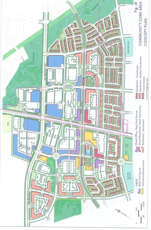
· Detailed Core Area Plan – The Core Area plan (Figure 28 in the March draft of the Implementation Guideline) has now been enlarged from 8.5” x 11” to a 24” x 36” drawing size and is included in a map pocket at the back of the document. The drawing shows a greater level of detail including landscape treatment, design of central parking areas and for street-oriented building siting (Document 3).
· Public Streets Plan – A new plan showing the required layout for the public street grid design has been added to the Implementation guideline (Document 4). This will ensure the establishment of key Core Area roads. The developer will be required to construct public streets that abut its development parcel as a condition of subdivision and site plan development approval.
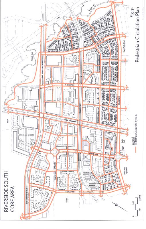
· Pedestrian Circulation Plan – The Pedestrian Circulation Plan (Figure 29 in the draft Implementation Guideline) has been enhanced to show a greater level of detail for the required major and minor pedestrian systems in the Core (Document 5). This will ensure safe and efficient pedestrian movement into, out of, and within the Core Area. The design and lighting of parking areas and pedestrian systems will be in accordance with CPTED (Community Planning Through Environmental Design) principles.
· Core Area Build-Out Plan – A plan showing conceptual development intensification for the Core Area has been added to the Implementation Guideline (Document 6). The plan looks into the future to illustrate, for example, the redevelopment of a large format retail store with several smaller retail stores, the addition of upper floors to Main street and Transit street buildings and also shows multi-level parking structures replacing at-grade parking lots. The plan also illustrates examples of locations where street-level stores can be incorporated in parking structures abutting public roads. The plan is intended to show the intent to permit development intensification in the Core over time, thereby supporting transit usage and enhancing the Core as a focus of community activity. The requirement to construct street level commercial uses in parking structures is part of the Implementation Guideline.
· Ensuring Street-Oriented Buildings – The Guideline text has been revised to reserve 25 metre wide areas of land as “building-only” areas abutting both sides of the Main street and Transit street rights-of-way. The guideline anticipates that buildings will occupy approximately 70% of the frontage of these streets as illustrated on the Core Area Concept Plan. Parking would not be permitted in the building-only areas until approximately 70% of the block frontage is occupied either by constructed buildings or is reserved for buildings through a registered site plan agreement. The Guideline also establishes maximum building setbacks from the public street to be implemented at the time of zoning. At the same time, the Guideline permits setback flexibility to provide for architectural creativity (i.e. for building elements such as façade articulation, forecourts and outdoor patios).
·
Encouraging “Green Building” Construction – Staff has been
exploring “green roofs” and ways to promote green building construction. Committee may already be aware of an
innovative "green roof" Wal-Mart store development that is currently
underway in Vancouver. Such
construction techniques are at the leading edge of design and represent a more
environmentally friendly approach. The greatest benefit of Green Roofs would be
realized when they are part of an integrated Green Building design. The goal of
encouraging Green Roofs and integrated environmental design in general in new
communities is in line with the City’s environmental efforts and staff
recommends encouraging such construction for institutional, commercial and
employment area buildings.
There are a number
of incentives that have been suggested to encourage such construction
techniques. Regulatory and incentive
options are being explored at present by City staff and through a Green Roofs
task force - with community, industry, research and city participation - which
was formed last year.
Staff has
amended section 2.2 of the Implementation Guideline, dealing with the
“Structuring Elements” of the community, to encourage green building
construction and integrated environmental design with a goal to achieve a
"LEED certified" standard (as set out in the April 19, 2005 report to
Corporate Services Committee dealing with City buildings). This change sets the stage for such design
standards and construction in future approval processes if related city-wide
policies and regulations are established.
While the City
does not have a mechanism to require the construction of green roofs for these
buildings, the CDP addresses the issues of “greening” in the Core Area, making
it a more pedestrian friendly place, planting to reduce wind speed, provide
shade and cool asphalt surface areas in a number of ways which can be
implemented at the time of development approval. These include, for example, reducing parking ratios, establishing
detailed pedestrian circulation systems and requiring a higher standard of tree
planting (to be detailed in the Core Area Urban Design Guideline).
The Core Area Urban Design Guideline (UDG) will provide a “tool kit” of urban design standards to be used in the preparation and review of applications for development approval in the Core Area. It will contain design “standards” (manufacturers specification sheets, sketches, plans and photographs) reflecting the theme selected for the Core. These standards will be required to be constructed by the proponent at the time of development within the Core. The Core Area UDG will include the following elements:
1. Main and Transit streets - plan and cross-section details showing locations for:
· Benches
· Waste receptacles
· Tree planting – species and frequency
· Streetlights
· Traffic circle design and landscape treatment
· Sidewalk design – concrete, pavers location and colour
· Textured pedestrian crossing design / locations
· Banners & flower baskets – suggested locations / styles
· Sidewalk restaurant patios – sample design(s)
2. Signage – style, material and maximum height / size for building facades, pylon signs. Style and sample locations for pedestrian directional signage.
3. Landscaping – tree planting details for sidewalks and parking areas.
4. Parking area pedestrian walkways - plan and cross-section widths, surface treatment and landscaping.
5. Parking area landscaping – parking aisle planting island and perimeter area plan and cross-section.
6. Lighting – decorative lighting styles for streets, parking areas and pedestrian walkways.
7. Fencing – decorative fencing options for outdoor patios, play structures in parks and “knee wall” options for parking area buffers.
8. Public squares - conceptual designs for the two public squares adjacent to the transit stations. Sketch plan of sub-neighbourhood park along Mosquito Creek adjacent to major recreational pathway.
9. Manufacturers specification sheets – will be the “standards” for the Core area including for example the following elements:
· Benches
· Waste receptacles
· Tree grates
· Street lights
· Walkway lights
· Brick paving stones (as required)
· Banners & Flower baskets
· Fencing
The Public Works and Services Department has agreed to approve the use of “non-standard” street right-of-way elements as will be set out in the Core Area UDG in recognition of the Core Area as a unique area in the community. Staff will work closely with the PWS department in the establishment of the design theme for the Core Area.
10. Image Bank - The Core Area UDG
will also include an “image bank” of photographs of constructed buildings
showing preferred architectural treatment to be applied to Core Area
buildings. A Core Area design review
committee will be struck to review applications for development in the
Core. Further to the March 8th
direction of Committee, Riverside South Development Corporation has agreed to
participate with the City in a consultative process for Core Area development
through the design review committee. The Committee will use the image bank to “test” whether or not
elevations proposed for buildings in the Core Area achieve the design intent
for the building relative to its location.
For example, buildings along Main and Transit streets are required to
have a functional building front (main entrance doorways and windows) facing
the public street and retail stores adjacent to arterial roads in the Core are
required to have or to emulate a building front elevation.
Examples of successful architectural treatment that has already been used on various buildings within and as close as possible to Ottawa will form part of the image bank. The image bank will include photographs of the following building types.
· “Main street” style retail, office and residential - individually and in mixed-use buildings including single and multi-storey examples.
· Large format retail with enhanced building façade treatment.
· Civic buildings.
Amendments
to Schedule “B” to the Ottawa Official Plan arising from the preparation of the
Riverside South CDP are recommended by staff for consideration by Planning and
Environment Committee as part of this report. Two sites are
affected by a proposed change from Employment to General Urban. One is located
to the northwest and the other to the southwest of the intersection of
Bowesville Road and Earl Armstrong Road. A woodlot located south of Earl
Armstrong Road and west of Spratt Road is subject to a proposed amendment from
General Urban to Urban Natural Features.
The detailed background and discussion of the proposed amendments, copies of the draft amendments and public consultation details are contained within the March 8, 2005 report to Planning and Environment Committee appended to this report in Document 7. It is required that the public meeting for the proposed Official Plan amendments be held again at this meeting of Committee. Note that the prior approval of the Community Design Plan is required in order to support the proposed Official Plan amendments.
CONSULTATION
The details of public consultation for the proposed Official Plan
amendments and for the Community Design Plan as of the March 8, 2005
presentation to Planning and Environment Committee are set out within Document
7 to this report.
The revised Community Design Plan, Official Plan amendments and the
proposed Core Area Urban Design Guidelines were presented at a public session
held in the Riverside South community prior to the date of this report to
Planning and Environment Committee. Since the finalization of this report was
prior to the public session in the community, Committee will be advised by
staff at the time of presentation of this report of any issues arising from the
public session not previously identified as part of the March 8, 2005 report to
Committee.
FINANCIAL IMPLICATIONS
The use of non-standard street light fixtures in the public
rights-of-way in the Core Area may have an on-going operating budget increase
due to light fixture maintenance and life cycle costs. Staff will select a
decorative light fixture style for the Core Area as part of the preparation of
the Core Area Urban Design Guidelines that will reflect the desired village
“theme” for the area but that will minimize potential increased operating
costs.
The cost of the preparation of the Core Area Urban Design Guidelines will be paid for through the growth studies component of Development Charges.
SUPPORTING DOCUMENTATION
Document 1 Community Design Plan – (revised) Implementation Guideline
(distributed separately and on file with the City Clerk)
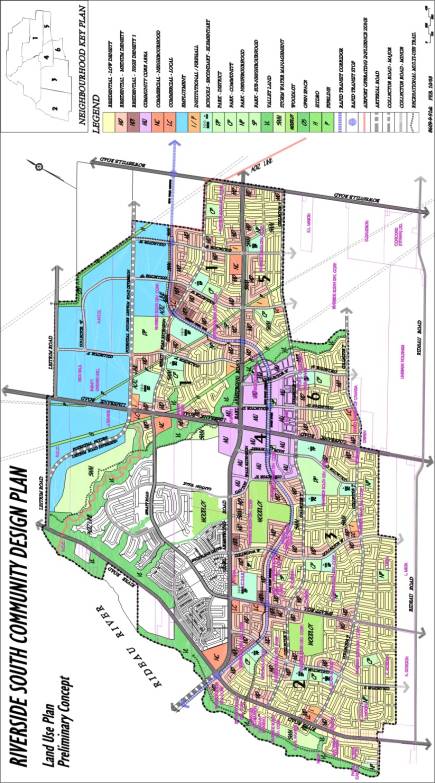
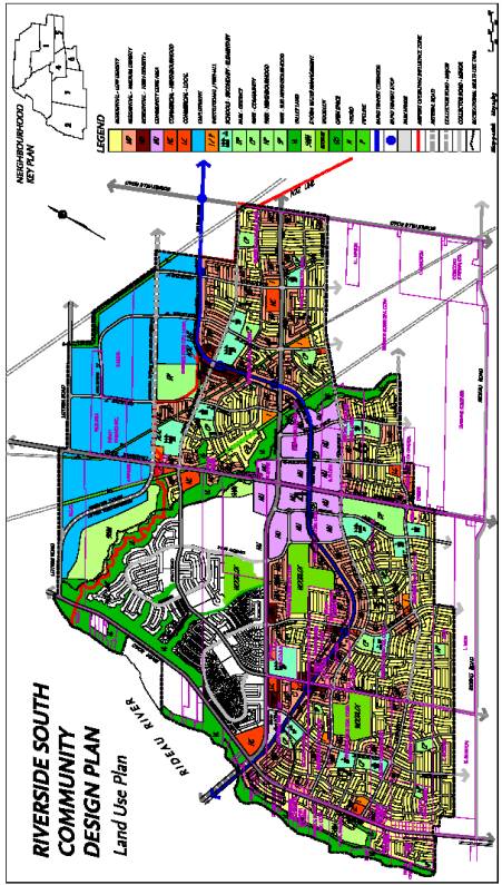
Document 2 Community Design Plan – (revised) Land Use Plan
Document 3 Community Design Plan – Detailed Core Area Plan
Document 4 Core Area Public Streets Plan
Document 5 Core Area Pedestrian Circulation Plan
Document 6 Conceptual Core Area Build-Out Plan
Document 7 March 8, 2005 Report to Planning and Environment Committee
(ACS2004-DEV-APR-POL-0008).
DISPOSITION
Department of Corporate Services,
Secretariat Services to notify the owner (Riverside South Development Corp. c/o
Urbandale Corporation, 2193 Arch Street, Ottawa, ON K1G 2H5 Attn. Mary Jarvis), D.W. Kennedy Consulting Limited, 604
Courtnay Avenue, Ottawa, ON K2A 3B5,
All Signs, 8692 Russell Road, Navan, ON
K4B 1J1, and the Program Manager, Assessment, Department of Corporate
Services of City Council’s decision.
Department of Corporate Services, Legal Services Branch to forward
the implementing by-law to City Council.
Department of Planning and Growth Management to undertake minor
modifications to Schedules "B", "E" and "I" to
the Ottawa Official Plan as set out in the March 8th, 2005 report
(Document 7) at the next general update to the Official Plan.
Department of Planning and Growth Management to prepare the Core Area
Urban Design Guidelines as set out in this report to be completed in 2005.
Community Design Plan – (revised) Land Use Plan Document 2
Community Design Plan – Detailed Core Area Plan Document 3
Core Area Public Streets Plan Document 4

Core Area Pedestrian Circulation Plan Document 5
Conceptual Core Area Build-Out Plan Document
6
MARCH 8, 2005 REPORT TO PLANNING AND ENVIRONMENT
COMMITTEE (ACS2004-DEV-APR-POL-0008) Document
7
Report to/Rapport au :
Planning and Environment Committee
Comité de l'urbanisme et de
l'environnement
and Council / et au Conseil
17 February 2005 / le 17 février 2005
Submitted by/Soumis par : Ned Lathrop, Deputy City Manager
/ Directeur municipal adjoint
Planning and Growth Management / Urbanisme
et Gestion de la croissance
Contact Person/Personne ressource : Richard
Kilstrom, Manager / Gestionnaire
Community Design and Environment / Conception et
milieu communautaire
(613) 580-2424 x22653, Richard.Kilstrom@ottawa.ca
|
Ref N°: ACS2004-DEV-POL-0008 |
|
SUBJECT: |
Riverside south community design plan and OFFICIAL PLAN AMENDMENTS
- EARL ARMSTRONG ROAD AT BOWESVILLE ROAD AND SPRATT ROAD (FILE NO.
D10-02-03-RV001, D01-01-04-0027) |
|
|
|
|
OBJET : |
PLAN DE CONCEPTION COMMUNAUTAIRE POUR RIVERSIDE-SUD ET
MODIFICATIONS DU PLAN OFFICIEL – CHEMIN EARL-ARMSTRONG À L'ANGLE DU CHEMIN
BOWESVILLE ET CHEMIN SPRATT |
REPORT RECOMMENDATION
That the Planning and
Environment Committee recommend:
1. That Council approve the Riverside
South Community Design Plan as detailed in Document 3 and,
2. That Council approve and adopt an
amendment to the Official Plan of the City of Ottawa to redesignate land
located to the northwest and to the southwest of the intersection of Earl
Armstrong Road and Bowesville Road from "Employment Area" to
"General Urban Area", as detailed in Document 6.
3. That Council approve and adopt an amendment to the Official
Plan for the City of Ottawa to redesignate land located west of Spratt Road
from "General Urban" to "Urban Natural Features", as
detailed in Document 6.
Que le Comité de l'urbanisme et de l'environnement recommande :
1. que
le Conseil approuve le Plan de conception communautaire pour Riverside-Sud, tel
que le montre en détail le document 3;
2. que
le Conseil approuve et adopte une modification du Plan officiel de la Ville
d'Ottawa ayant pour effet de changer de « Secteur d'emploi » à « Zone urbaine
générale » la désignation des terrains situés au nord-ouest et au sud-ouest de
l'intersection des chemins Earl-Armstrong et Bowesville, tel que le montre en
détail le document 6;
3. que le Conseil approuve et
adopte une modification du Plan officiel de la Ville d'Ottawa ayant pour effet
de changer de « Zone urbaine générale » à « Caractéristiques naturelles
urbaines » la désignation des terrains situés à l'ouest du chemin Spratt, tel
que le montre en détail le document 6.
EXECUTIVE SUMMARY
The purpose of preparing a Community Design Plan (CDP) is to establish a community-wide land use framework that reflects the principles, objectives and policies for community development as directed by the Official Plan. The CDP provides a level of detail in-between official plan policy and development approval and enables communities to establish incrementally over time in an optimum and coordinated manner. Community Design Plans are used as a tool to guide the preparation and review of applications for development.
The CDP was prepared through 2003/2004 for land in Riverside South affected by the “Developing Communities” and “Employment” designations. It was guided by public advisory and technical advisory committees and involved broad input from the public, City advisory committees, internal City departments, outside technical agencies, school boards and a community landowner group. The study process included preparation of updates to master servicing studies for sanitary sewer, storm sewer and drinking water. Transportation, environmental evaluation and commercial facility market demand studies were also prepared.
The CDP establishes the arrangement of the public road network, municipal water and storm water management and sanitary sewer infrastructure, rapid transit corridor, the location of residential, commercial and institutional uses, schools, parks and open space linkages. The Community Design Plan for Riverside South is comprised of an Implementation Guideline document and Land Use Plan supported by the various background studies. The CDP affects approximately 210ha (520ac) of Employment land and approximately 1255ha (3100ac) of primarily General Urban land providing for approximately 22,500 jobs, 16,200 dwelling units and an estimated population of 43,000 people.
Changes to the Schedules of the Official Plan are recommended as a result of the preparation of the CDP for Riverside South. Certain of the recommended changes require formal amendment. For the majority of changes arising from the CDP study process, the Official Plan (OP) provides the ability to make minor adjustments without formal amendment.
The public meeting
for the following changes to Schedule “B” that require formal amendment is
being held as part of this report to Committee. Two sites are affected by a
proposed change from Employment to General Urban. One is located to the
northwest and the other to the southwest of the intersection of Bowesville Road
and Earl Armstrong Road. A woodlot located south of Earl Armstrong Road and
west of Spratt Road is subject to a proposed amendment from General Urban to
Urban Natural Features.
The purpose of this report is to:
a) Present the recommended Community Design Plan to Committee for recommendation to Council for approval and,
b) Hold the required public meeting for the proposed Official Plan amendments.
Financial
Implications:
Development of major servicing infrastructure will be financed through development charges. Development of parks and recreational trails and preparation of studies providing for future planning and design in the community are primarily financed through development charges but carry a minor percentage of “benefit to existing” the resultant cost of which is paid for by the City. Council dealt with the structure of these costs through approval of the recent Development Charges by-law.
Public
Consultation/Input:
Two advertised public open house meetings were held in the community at key junctures in the study. The first open house was held on June 26, 2003. The purpose of this meeting was to obtain public comment on the proposed study components, timeframes and background materials. The public viewed display materials including base information on the environment, servicing, transportation and land use planning that would be reviewed and updated as part of the study. Approximately 80 people attended the open house meeting. The proposed CDP study was generally well accepted by the public.
The second public open house meeting was held in the community on June 22, 2004. Approximately 200 people attended the open house meeting. The purpose of the second open house meeting was to display for public review and comment a draft of the CDP Implementation Guideline and Land Use Plan as well as the various background studies updated and prepared in support of the CDP. The public response to the proposed CDP was generally positive. A summary of comments received from the public is set out in Document 8.
RÉSUMÉ
Hypothèses
et analyse :
Un
Plan de conception communautaire (PCC) a pour objet d'établir, pour l'ensemble
d'une communauté, un cadre d'utilisation du sol qui reflète les principes, les
objectifs et les politiques d'aménagement communautaire énoncés dans le Plan
officiel. Le PCC contient des détails d'un niveau intermédiaire entre celui des
politiques du Plan officiel et celui du processus d'approbation des
aménagements et il permet aux communautés de se développer progressivement, de
manière optimale et coordonnée. Le Plan de conception communautaire sert à
orienter la préparation et l'examen des demandes d'aménagement.
Un PCC a été préparé tout au long de 2003 et
2004 pour des terrains dans Riverside-Sud désignés « Communauté en
développement » et « Secteur d'emploi ». Il a été guidé par les
travaux de comités consultatifs publics et techniques et a bénéficié d'une
large participation de la part du public, de comités consultatifs de la Ville,
de services municipaux internes, d'organismes techniques externes, de conseils
scolaires et d'un groupe de propriétaires du secteur. Le processus a exigé la
préparation de mises à jour des études cadres de viabilisation pour les égouts
sanitaires et pluviaux et les aqueducs. Des études sur les transports, des
évaluations environnementales et des études de demande du marché pour des
installations commerciales ont également été effectuées.
Le PCC établit la disposition du réseau routier
public, de l'infrastructure de gestion du réseau municipal d'aqueducs et
d'égouts pluviaux et sanitaires, le couloir de transport en commun rapide,
ainsi que l'emplacement des utilisations résidentielles, commerciales et
institutionnelles, des écoles, des parcs et des couloirs d'espace ouvert. Le
Plan de conception communautaire pour Riverside-Sud comprend des lignes
directrices de mise en œuvre et un plan d'utilisation du sol étayés par
diverses études de fond. Le PCC vise environ 210 ha (520 acres) zonés
« Secteur d'emploi » et 1 255 ha (3 100 acres) zonés
principalement « Zone urbaine générale » où se trouvent
approximativement 22 500 emplois, 16 200 unités de logement et une
population estimée de 43 000 personnes.
Il est recommandé que des révisions soient
faites aux annexes du Plan officiel pour donner suite au PCC pour
Riverside-Sud. Certaines des révisions recommandées exigent une modification
formelle, mais pour la plupart d'entre elles le Plan officiel offre la
possibilité d'apporter des aménagements mineurs au texte sans recourir à la
procédure de modification formelle.
La réunion publique
que nécessitent les deux modifications formelles suivantes de l'annexe B se
tient dans le cadre de la présentation du rapport au Comité. Deux endroits sont
visés par la proposition de modifier le zonage de « Secteur
d'emploi » à « Zone urbaine générale », l'un au nord-ouest et
l'autre au sud-ouest de l'intersection des chemins Bowesville et
Earl-Armstrong. La proposition de modifier le zonage de « Zone urbaine
générale » à « Caractéristiques naturelles urbaines » vise un boisé
situé au sud du chemin Earl-Armstrong et à l'ouest du chemin Spratt.
Le présent rapport a
pour objet:
a)
de
présenter la proposition de Plan de conception communautaire au Comité pour
qu'il en recommande l'approbation au Conseil;
b)
de
tenir la réunion publique exigée pour apporter les modifications proposées au
Plan officiel.
Répercussions
financières :
La
mise en place des éléments majeurs de l'infrastructure de viabilisation sera
financée à même les redevances d'aménagement. La création de parcs et de
sentiers récréatifs et la réalisation d'études portant sur la planification et
la conception futures dans la communauté seront financées principalement au
moyen de redevances d'aménagement, mais une petite fraction des coûts qui en
résultent seront imputables à la Ville au titre des « avantages aux
propriétaires existants ». Le Conseil a déterminé le barème de ces coûts
dans le récent Règlement municipal sur les redevances d'aménagement.
Consultation publique / commentaires :
Deux réunions publiques « portes
ouvertes » ont été annoncées et organisées dans la communauté à des
moments clés de l'étude. La première, qui a eu lieu le 26 juin 2003, avait pour
objet de recueillir les observations du public sur les éléments proposés pour
l'étude, l'échéancier et les documents de fond. Le public a pu étudier le
matériel exposé et les documents, y compris les renseignements de base portant
sur l'environnement, la viabilisation, les transports et la planification des
utilisations du sol à être examinés et mis à jour dans le cadre de l'étude. Environ
80 personnes ont assisté à cette réunion, et l'étude proposée pour le PCC a été
généralement bien accueillie par le public.
La deuxième réunion publique s'est tenue le 22
juin 2004 et a attiré environ 200 personnes. Elle avait pour objet de soumettre
à l'examen et à la critique du public le projet de lignes directrices de mise
en œuvre et de plan d'utilisation du sol, de même que les diverses études de
fond mises à jour et préparées en prévision du PCC. La réaction du public au
PCC proposé a été généralement positive. Le résumé des observations formulées
par le public figure dans le document 12.
The purpose of preparing a Community Design Plan (CDP) is to establish a community-wide land use framework that reflects the principles, objectives and policies for community development as directed by the Official Plan. It represents a synthesis of the many layers that comprise successful and liveable communities. It provides a level of detail in-between official plan policy and development approval and enables communities to establish incrementally over time in an optimum and coordinated manner. Community Design Plans are used as a tool to guide the preparation and review of applications for development.
The Official Plan for the City of Ottawa (OP) under Section 3.6.4 requires that a Community Design Plan (CDP) be prepared for land affected by the Developing Community designation. The majority of undeveloped land designated as General Urban in the Riverside South community (formerly Gloucester South Urban Centre) is within the Developing Community designation. Although not part of the Developing Community, Employment Area land in Riverside South was also included in the study area and forms part of the CDP to ensure employment objectives as set out in the OP are achieved and that land use, transportation and servicing are planned comprehensively.
The need to prepare a CDP for Riverside South resulted from applications made jointly by Urbandale and Richcraft just prior to municipal amalgamation for amendments to the Gloucester and Regional Official Plans. The applicants sought to expand the urban boundary in south Gloucester to provide for additional land to accommodate projected urban growth, based on development densities typical for the area. The Gloucester amendment was adopted by former Gloucester Council but was not approved by the former Regional Municipality. The Regional amendment was held in abeyance until master transportation and servicing studies could be updated as part of the Official Plan review process. The new Official Plan identified the requirement to prepare a CDP for the community.
The preparation of a Community Design Plan for the Riverside South Community was included in the 2003 study work plan for the Development Services Department. The terms of reference were presented to Committee in June of 2003 and were subsequently endorsed by Council. The CDP study was approved for urban area land within the Developing Communities designation and Employment lands. The study was carried out in 2003 and in 2004. It was guided by public advisory and technical advisory committees and involved broad input from the public, City advisory committees, internal City departments, outside technical agencies, school boards and a community landowner group. The study process included preparation of updates to master servicing studies for sanitary sewer, storm sewer and drinking water. Transportation, environmental evaluation and commercial facility market demand studies were also prepared.
The purpose of this report is to:
a) Present the recommended Community Design Plan to Committee for recommendation to Council for approval and,
b) Hold the required public meeting for the proposed Official Plan amendments.
Note that approval of the Community Design Plan is required in order to support the proposed Official Plan amendments.
The Riverside South Community is an 1800-hectare community located to the southwest of the Macdonald Cartier airport. Originally part of the South Urban Centre of the former City of Gloucester, it became part of the City of Ottawa through amalgamation in 2001. The community is generally located south of Leitrim Road and the airport, west of Bowesville Road, east of the Rideau River and north of the urban boundary (Document 1). It is roughly comprised of four quadrants of land divided by Limebank Road and Earl Armstrong Road. The Mosquito Creek valley bisects the community in a southeast to northwest direction.
The entire Riverside South area was included the study area for the Community Design Plan (CDP) to enable the analysis of total dwelling units, population and employment in terms of effect on transportation and servicing capacities. The Developing Communities designation in the Official Plan applies to primarily undeveloped General Urban land in the community. The northwesterly quadrant of the community west of the Mosquito Creek is largely developed or under development and therefore is not part of the Developing Communities designation in the Official Plan and is not subject to the CDP. The Developing Communities designation also does not apply to the Employment Area in the northeasterly part of the community however the employment land at approximately 210 ha / 520 ac is included in and is subject to the CDP. The Area of Operating Influence Zone (AOIZ) limit for the airport traverses the northerly part of the community and establishes the boundary between the Employment lands and General Urban (residential) neighbourhoods. The total area subject to the CDP is approximately 1465 ha / 3620 ac.
A Major Open Space designation applies to the Mosquito Creek Valley and to land along the Rideau River. Two woodlot areas, one to the north and one to the south of Earl Armstrong Road, are designated Urban Natural Features. A small area in the northwest quadrant is designated Greenbelt Rural (Document 2). The Employment Area on the east abutting Bowesville Road is subject to a proposed redesignation to General Urban. A woodlot located on the west side of Spratt Road south of Earl Armstrong Road is subject to a proposed redesignation from General Urban to Urban Natural Features. These Official Plan amendments, proposed as a result of the direction of the CDP, are discussed later in this report.
Since the Ottawa Official Plan is under appeal, the Gloucester Official Plan and Regional Official Plan are still in effect. The CDP however was prepared under the provisions of the adopted Ottawa Official Plan and therefore does not reflect the policies of the Gloucester or Regional Official Plans. Amendments to the Gloucester and Regional Official Plans are not proposed at this time to implement the new CDP since it is anticipated that appeals to the Ottawa OP will be dealt with prior to development approvals within the area affected by the CDP. Should amendments to the Gloucester and Regional Official Plans become necessary in order to support applications for development that are in compliance with the approved CDP, they will proceed on an as-required basis. If the policies of the Ottawa OP change as a result of the current appeals a subsequent report to Committee recommending any required changes to the CDP will be prepared.
The
design plan prepared for the community in 1992 by the City of Gloucester
provided for a total of 11,000 dwelling units and a population of 31,500
(Gloucester Official Plan Amendment 3 in 1992 provided for 7,000 to 11,000
dwelling units and 10,000 to 14,000 jobs) based on servicing capacities for the
area established at the time. The southerly part of the community was within a
“Transportation Study Area” in the Gloucester Official Plan and within the
“South Urban Centre Future Development” designation in the Regional Official Plan.
It was anticipated at the time that Armstrong Road (now Earl Armstrong Road)
and Limebank Road would be significantly realigned. These significantly shaped
the 1992 design of the community.
Recent changes to the transportation systems in the community have been instrumental in shaping the new patterns of land use now recommended for Riverside South. An Environmental Assessment completed in May 2003 for Limebank Road and Earl Armstrong Road determined that the road alignments should remain primarily on their existing alignments. The 2003 Official Plan established that a rapid transit corridor should connect the Riverside South community, and points to the west, to downtown. The Environmental Assessment for the north / south rapid transit corridor is currently underway. The expected completion date for the EA is later this year.
The rapid transit alignment location and geometry, the timing of construction, number, type and location of stations / stops are subject to the approval of the Environmental Assessment. At the time of writing this report, the preferred alignment resulting from the EA process thus far required that a section of the alignment be rerouted to the south to avoid radio broadcast towers located east of Spratt Road and south of Earl Armstrong Road. Given that this change in the design occurred late in the CDP study process, two Land Use Plans are attached to this report to demonstrate to Committee the affect of the change. Document 4 shows the rapid transit alignment presented at a public open house meeting in the spring of 2004. Document 5, the revised Land Use Plan now subject to approval by Committee, shows the rapid transit alignment that corresponds with the preferred alignment identified in the EA. Affected landowners have been contacted regarding the change.
If substantive changes to the Community Design Plan are necessary as a result of the final completion of the EA, staff will prepare a report recommending changes for consideration by Planning and Environment Committee.
The Community Design Plan for Riverside South is comprised of an Implementation Guideline document and Land Use Plan supported by the various background studies. Amendments to the Official Plan to redesignate certain Employment Area land to General Urban and to redesignate a woodlot from General Urban to Urban Natural Features is recommended as part of the approval of the CDP. The CDP itself is not a statutory document adopted by Council as a Secondary Plan. Rather, as a Council approved document, it provides flexibility by setting out an implementation framework that guides where staff may approve minor modifications and where more substantive changes must be reviewed and approved by Committee and Council.
The CDP study was carried out in 2003 and 2004. The study was a collaborative effort involving broad input from various Federal, Provincial and private technical agencies, school boards, City departments and advisory committees, a study area landowner group, the Riverside South Community Association and the public. The following participated in the study:
Two advertised public open house meetings were held in the community at key junctures in the study. The first open house was held on June 26, 2003. Notice of this meeting was published in the Ottawa Citizen and Le Droit newspapers on Friday, June 20, 2003 and in the Riverside / Hunt Club News on Thursday, June 19, 2003. Notice of the meeting was also mailed out to the study Landowner group. The purpose of this meeting was to obtain public comment on the proposed study components, timeframes and background materials. The public viewed display materials including base information on the environment, servicing, transportation and land use planning that would be reviewed and updated as part of the study. Approximately 80 people attended the open house meeting. The proposed CDP study was generally well accepted by the public. Key concerns expressed primarily related to transportation matters including the nature and timing of future road improvements needed to serve the community and the timing and location of the future rapid transit corridor.
The second public open house meeting was held in the community on June 22, 2004. Notice of this meeting was published in the Ottawa Citizen and LeDroit newspapers on June 11, 2004, in the Riverside / Hunt Club News on June 17, 2004 and was also mailed directly to all study area landowners and to those within 120 metres of the study area. Approximately 200 people attended the open house meeting. The purpose of the second open house meeting was to display for public review and comment a draft of the CDP Implementation Guideline and Land Use Plan as well as the various background studies updated and prepared in support of the CDP. The meeting also fulfilled the requirement under the Environmental Assessment Act to hold a public meeting for the update to the Master Drainage Plan (storm water management) for the community. In addition to extensive study background information, summaries of the following draft documents were displayed:
Full copies of
all draft documents were available for public review at the meeting. Attendees
were asked to comment on the draft materials. Although comments were generally
positive, key concerns expressed at and following the meeting included
provision of an adequate transportation network for the community and the
location of the future rapid transit corridor.
A summary of comments received from the public open houses and from other study meetings and submissions is set out in Document 8.
The background studies (noted above) prepared in support of the Riverside South CDP demonstrate that, subject to phased implementation of recommended works, development of all urban land in the community can occur. These studies, although not physically attached to the CDP Implementation Guideline document, are referenced within and form part of the approved CDP. The servicing studies have not been finalised as of the date of this report. To enable a recommended CDP to be brought forward to Committee, Staff from the Infrastructure Approvals Branch has indicated that the Master Drainage Plan, the Master Servicing Study and the Water Supply Assessment are sufficiently complete to ensure that the arrangement of land use shown on the CDP will not be significantly affected as a result of the finalisation of the studies. These studies will be approved as required to provide for development of land within the area affected by the CDP. The Transportation Study, Woodlot Study, Commercial Facilities Market Demand Study and the Community Design Plan - Implementation Guidelines and Land Use Plan are completed in final draft form as of the date of this report.
Summaries of each of the background studies to the CDP are set out in the Implementation Guideline document. The following summarises the key outcomes of each document:
The Official Plan for the City of Ottawa requires that a target of at least 1.3 jobs per household be achieved for growth communities located outside of the greenbelt. Through the preparation of the CDP it was demonstrated that this target can be achieved without employment uses being located in the area subject to this proposed amendment. Redesignating to General Urban therefore provides for an optimum balance of housing and jobs in the community and makes best use of urban area land. The area would be comprised of approximately 650 low and medium density dwelling units and portions of two neighbourhood parks. [U1]
Environmental Implications
No environmental implications were identified for the subject lands as part of the CDP study process.
The
woodlot in this location is at present the only significant woodlot of a total
of eight identified in the May 2004 report by Niblett Environmental Associates
Inc. that is not within either the Major Open Space (valley land woodlots) or
Urban Natural Features (tableland woodlots) designations. The redesignation
reflects the intent of the CDP design to maintain the significant woodlots as
public amenity spaces. The woodlot will be maintained in a natural state and
not be used for active parkland purposes.
Environmental Implications
The local environment is enhanced through the preservation of this woodlot.
Consultation – Proposed Amendments:
Notice of the proposed amendments was carried out in accordance with the City’s Public Notification and Consultation Policy. Information signs were posted on-site indicating the nature of the amendments. The Ward Councillor is aware of the amendments and the staff recommendation. The City did not receive any negative comments or opposition to the amendments.
Detailed responses to the notification/circulation are provided in Document 7.
APPLICATION PROCESS TIMELINE STATUS
This application was not processed within the timeframe established for the processing of Official Plan Amendments due to the additional time needed to complete the Riverside South Community Design Plan and the related interim master servicing studies.
FINANCIAL IMPLICATIONS – CDP and Official Plan Amendments
Development
of major servicing infrastructure will be financed through development charges.
Development of parks and recreational trails and preparation of studies
providing for future planning and designing in the community carry a minor
percentage of “benefit to existing” the resultant cost of which is paid for by
the City. Council dealt with the structure of these costs through approval of
the recent Development Charges by-law.
SUPPORTING DOCUMENTATION
Document 2 Extract from
Official Plan Schedule "B"
Document 3 Community Design
Plan Implementation Guideline
(distributed separately to Committee and on file with the City Clerk)
Document 4 Community Design Plan - Land Use Plan (old
version)
Document 5 Community Design Plan - Land Use Plan
(revised for approval)
Document 6 Proposed Official Plan Amendments
Document 7 Consultation Details: Official Plan
Amendments
Document 8 Consultation Details: Community Design
Plan
DISPOSITION
Department of Corporate Services, Secretariat Services to forward the Riverside South Community Design Plan to Council for approval prior to its approval of the related Official Plan amendments.
Department of Corporate Services, Secretariat
Services to notify the owner (Riverside South
Development Corp. c/o Urbandale Corporation, 2193 Arch Street, Ottawa, ON K1G 2H5 Attn. Mary Jarvis), D.W. Kennedy
Consulting Limited, 604 Courtnay Avenue, Ottawa, ON K2A 3B5, All Signs, 8692 Russell Road, Navan, ON K4B 1J1, and the Program Manager,
Assessment, Department of Corporate Services of City Council’s decision.
Department of
Corporate Services, Legal Services Branch to forward the implementing by-law to
City Council.
Department of
Planning and Growth Management to undertake minor modifications to Schedules
"B", "E" and "I" to the Ottawa Official Plan as
set out in this report at the next general update to the Official Plan.
LOCATION MAP Document
1
EXTRACT FROM OFFICIAL PLAN SCHEDULE “B” Document 2
COMMUNITY DESIGN PLAN – LAND USE PLAN (old
version) Document 4
COMMUNITY DESIGN PLAN – LAND USE PLAN (revised
for approval) Document 5
PROPOSED OFFICIAL PLAN AMENDMENTS Document
6
OFFICIAL PLAN AMENDMENT No. __ TO THE
OFFICIAL PLAN (2003) OF THE CITY OF OTTAWA
THE STATEMENT OF COMPONENTS
PART A - THE PREAMBLE
1.0 Purpose
2.0 Location
3.0 Basis
PART B - THE AMENDMENT
1.0 Introduction
2.0 Details
3.0 Implementation
OFFICIAL PLAN AMENDMENT No. __ TO THE OFFICIAL PLAN (2003) OF THE CITY OF OTTAWA
PART A – THE PREAMBLE, introduces the actual Amendments but does not constitute part of Official Plan Amendment No. __ to the Official Plan (2003) of the City of Ottawa.
PART B - THE AMENDMENT, constitutes the actual Official Plan Amendment No. __ to the Official Plan (2003) of the City of Ottawa.
PART A – THE PREAMBLE
1.0
Purpose
The
purpose of Amendment No. __ is to change on Schedule “B” to the Official Plan
(2003) of the City of Ottawa the designation of land located in the Riverside
South Community from “Employment Area” to “General Urban Area” and from
“General Urban Area” to “Urban Natural Features”.
The subject sites are located within the urban area in the Riverside South community.
The sites
subject to the proposed change from Employment Area to General Urban Area are
comprised of two areas of undeveloped land west of Bowesville Road, one on the
north and one on the south of Earl Armstrong Road. The northerly area is
approximately 25 ha / 62 ac in size and the southerly area is approximately 29
ha / 72 ac in size.
The site subject to the proposed change from General Urban Area to Urban Natural Features is located with frontage on the west side of Spratt Road approximately one kilometre south of Earl Armstrong Road. The site is comprised of a 15 ha / 37 ac woodlot.
3.0 Basis
The proposed
amendments arise from the Community Design Plan for the Riverside South
Community (CDP) that has now been completed.
Change from
Employment Area to General Urban Area – Bowesville Road:
The Official
Plan (2003) of the City of Ottawa requires that a target of at least 1.3 jobs
per household be achieved for growth communities located outside of the
greenbelt. Through the preparation of the CDP it was demonstrated that this
target could be achieved without employment uses being located in the area
subject to this proposed amendment. Redesignating to General Urban therefore
provides for an optimum balance of housing and jobs in the community and makes
best use of urban area land. The area would be comprised of approximately 650
low and medium density dwelling units and portions of two neighbourhood parks.
The master servicing studies prepared in support of the CDP for water, sewer
and storm water management demonstrate that the area can be serviced. This
amendment to the Official Plan (2003) of the City of Ottawa implements the
recommendations of the CDP.
Change from General Urban Area to Urban
Natural Features - Spratt Road:
The woodlot in
this location is at present the only significant woodlot of eight identified in
a May 2004 report by Niblett Environmental that is not within either the Major
Open Space (valley land woodlots) or Urban Natural Features (tableland
woodlots) designations. The redesignation reflects the intent of the CDP design
to maintain the significant woodlots as public amenity spaces. The woodlot will
be maintained in a natural state and not be used for active parkland purposes.
All of this part of this document entitled Part B - The Amendment, consisting of the following changes, represents Official Plan Amendment No. __ to the Official Plan (2003) of the City of Ottawa.
The following changes are hereby made to the Official Plan (2003) of the City of Ottawa:
1.0 Schedule B, Urban Policy Plan, is hereby amended by deleting “Employment Area” and replacing it with “General Urban Area” and by deleting “General Urban Area” and replacing it with “Urban Natural Features” as shown on Schedule 1 hereto.
This amendment
shall be implemented by the powers conferred upon the City of Ottawa by the
Planning Act, The Municipal Act and any other statutes that may apply.
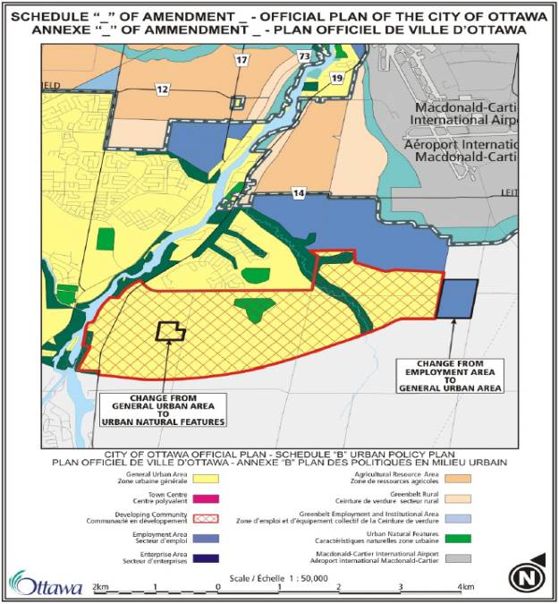
CONSULTATION DETAILS Official Plan Amendments: Document
7
NOTIFICATION AND CONSULTATION
PROCESS
Notification and public
consultation was undertaken in accordance with the Public Notification and
Public Consultation Policy approved by City Council for Official Plan
Amendments. Prior to public
notification being given for the proposed amendments, one public open house
meeting was held in the community as part of the Riverside South Community
Design Plan. Information provided at the open house meeting showed the intended
use of the subject sites as now proposed in the amendments.
PUBLIC COMMENTS
No comments objecting to the proposed amendments were received as a result of the technical circulation or public notice.
SUMMARY OF PUBLIC INPUT
Two owners of property on Bowesville Road inquired on the telephone as to the nature of the proposed amendment from Employment Area to General Urban Area and of the possible timing for development in the affected area. No comments from the public were received with respect to the proposed amendment from General Urban to Urban Natural Features.
COUNCILLOR’S COMMENTS
No comments submitted.
COMMUNITY ORGANIZATION COMMENTS
No comments submitted.
ADVISORY COMMITTEE COMMENTS
Environmental Advisory Committee:
Comment - The Environmental Advisory Committee is in support of rezoning this land from Employment to General Urban. However, it wishes to comment that the land is currently in agricultural use and as a result once this land is developed it will no longer be available for garden or food production. This is a small point with respect to this particular piece of land, but a large point when we consider the long term need to protect agricultural land near our urban areas for food production. If we are to achieve a sustainable community in the long run, a City strategy for protecting agricultural land needs to be put in place.
EAC Recommendation: That the City of Ottawa conduct an inventory of existing agricultural land and potential agricultural land and develop a strategy for its protection consistent with long term food security and community sustainability.
Response:
The former Regional Municipality of Ottawa-Carleton undertook the “Land
Evaluation for Agriculture” (LEAR) study in the mid 1990’s for the 1997
Regional Official Plan. This detailed study reviewed agricultural capability on
a property-by-property basis for the entire rural part of the municipality. The
policies in the new City of Ottawa Official Plan also reflect the results of
the study protecting agricultural resource land from development. The Province
of Ontario through its Provincial Policy Statement also protects agricultural
land.
CONSULTATION
DETAILS Community Design Plan: Document
8
Community Design Plan Open House
Meeting #1:
The first open house was held on June 26, 2003. Notice of this meeting was published in the Ottawa Citizen and Le Droit newspapers on Friday, June 20, 2003 and in the Riverside / Hunt Club News on Thursday, June 19, 2003. Notice of the meeting was also mailed out to the study Landowner group. The purpose of this meeting was to obtain public comment on the proposed study components, timeframes and background materials. The public viewed display materials including existing base information on the environment, servicing, transportation and land use planning that would be reviewed and updated as part of the study. Approximately 80 people attended the open house meeting.
Nine submissions providing comments on the open house materials were received. The following summarises the main points:
Comment - Concerned about airport noise affecting the existing residential area.
Response – Noise sensitive (residential) land use both in the existing and future development areas is located outside of the airport Area of Operating Influence Zone line.
Comment – Prefer the southerly alignment option for the future rapid transit corridor.
Response – The southerly alignment has been selected and is shown on the CDP.
Comment – Secondary schools are needed to support the local elementary schools.
Response – Four high schools are planned in the CDP area.
Comment – Don’t want as much commercial as in Barhaven.
Response – The primary commercial area for Riverside South is much smaller than that planned for Barhaven. The appropriate balance of commercial space for Riverside South has been studied as part of the preparation of the CDP. Retail commercial space in Riverside South is to be concentrated in the Core Area, supported by several smaller commercial plazas located in the community.
Comment – Hope that the combination of the Mosquito Creek valley and the storm water management ponds provide a buffer from the existing residential area.
Response – The forested valley and storm water management facility combined width of approximately 300 metres provides a significant buffer between the existing residential area and the employment lands.
Comment – Concerned that sites for places of worship will not be made available in the community.
Response – Eight new institutional sites (not including school sites) are included on the Land Use Plan.
Comment – Additional park-and-ride lots are needed for Riverside South residents.
Response – A large park-and-ride lot is planned adjacent to the Leitrim / transit right-of-way intersection (to the northeast of the community). Transit parking facilities are also planned to be located within the new Core area. The EA for the transit extension may identify additional park and ride facilities in the community.
Comment – Improvements are needed to major roads in the area (River Road, Limebank Road, Bowesville Road and others) to accommodate existing and future traffic volumes.
Response – The Transportation report prepared in support of the CDP sets out a phased road improvement schedule.
Comment – Concerned about potential adverse noise from the rapid transit (if rail based).
Response
– The EA being carried out this year for the rapid transit extension will
address noise impact issues and recommend measures to mitigate source noise.
Community Design Plan Open House
Meeting #2:
The second public open house meeting was held in the community on June 22, 2004. Notice of this meeting was published in the Ottawa Citizen and LeDroit newspapers on June 11, 2004, in the Riverside / Hunt Club News on June 17, 2004 and was also mailed directly to all study area landowners and to those within 120 metres of the study area. Approximately 200 people attended the open house meeting. The purpose of the second open house meeting was to display for public review and comment a draft of the Community Design Plan Implementation Guideline document, Land Use Plan and the various background studies updated and prepared in support of the CDP. The meeting also fulfilled the requirement under the Environmental Assessment Act to hold a public meeting for the update to the Master Drainage Plan (storm water management) for the community.
Seven submissions providing comments on the open house materials were received. The following summarises the main points:
Comment – Improvements are needed to major roads in the area (River Road, Limebank Road, Bowesville Road and others) to accommodate existing and future traffic volumes.
Response – The Transportation report prepared in support of the CDP sets out a phased road improvement schedule.
Comment – Light rail transit to the community is a necessity.
Response – The EA for the rapid transit extension to the south is to be completed this year. Construction will follow to be phased contingent on budget allocation.
Comment – Prefer the southerly alignment option for the future rapid transit corridor.
Response – The southerly alignment has been selected and is shown on the CDP.
Community Organisation Comments:
Riverside South Community
Association:
Comment - The Community Association has commented that it is satisfied and supportive of the CDP as presented and discussed on January 7, 2005.
Advisory Committee Comments:
Local Architectural Conservation
Advisory Committee:
Response – The woodlots will be left in their natural state and without formal public access and use. The Official Plan requires the preparation of an Environmental Impact Statement for all development proposed within 30 metres of land designated Urban Natural Features. The EIS will establish if a perimeter buffer is required. The principal wildlife corridor is the Mosquito Creek Valley that is centrally located through the community and connects to the Rideau River valley system. Sub-corridors are provided through green corridors extending east from the Mosquito Creek into Neighbourhood 1 and to the south into Neighbourhood 3, also linking two of the three woodlots with the Mosquito Creek.
Comment - Trees and other vegetation should be preserved in the community. Areas of existing trees should be incorporated into parks and schools. Schools should be designed with increased shade areas and healthier outdoor environments and be located away from (airport) noise sources. Consider use of “green” roofs to enhance the environment and reduce the amount of rainwater runoff into the storm sewer system.
Response – The three main woodlots in the community are being donated to the City by the landowner thereby providing additional vegetated green space. The Official Plan objective of 4 hectares of green space per 1000 population in the community is exceeded. Additional trees or treed areas to be retained will be identified through a “Tree Preservation Plan”, required at the time of development approval. Areas of existing trees have been incorporated where possible into portions of school and park blocks. This will be investigated further at the time of development. Landscape plans are required for all schools at the time of development approval. Schools and other noise sensitive uses of land are located outside of the airport area of operating influence zone. The use of green roof alternate designs is permitted however substantive and guaranteed long term use is required in order to factor the reduced amount of rainwater runoff into the major stormwater management systems for the community.
Comment - Consider allowing public spaces to be designed by the people of the community rather than by the City.
Response – The public are involved through a consultative process in the design of park spaces in the community. The process is City-led to ensure issues of public safety and interest are addressed through the design process.
Forests
and Greenspace Advisory Committee:
Comment – Concerned that the “Significant Woodlot Study Update” (Niblett) did not re-evaluate all woodlots in the CDP area. An important woodlot was identified but was not recommended to be saved. There is no mention of hedgerows or important individual trees in the report. Detailed comments recommending changes to the draft Implementation Guidelines to help “green” the community were submitted.
Response – The primary focus of the update was to reconfirm importance of the three large significant woodlots and to assist in evaluating storm water management pond locations on the northerly portion of the Mosquito Creek. All treed areas are evaluated at the time of development approval through the preparation of a Tree Preservation Plan. The remaining important woodlot has been added (was missed by “typo” previously) to the list of woodlots recommended to be saved. The report has been amended and a section in the CDP Implementation Guidelines added to deal with hedgerows. Important individual trees and hedgerows are evaluated for retention at the time of development approval through the preparation of a Tree Preservation Plan. Such “subdivision” level of detail planning was not carried out as part of the higher level CDP planning process. Most of the “greening” suggestions submitted by the OFGAC were implemented in the revised Guidelines for the CDP.
Public Agency Comments:
National Capital Commission:
Comment – Concerned that a proposed storm water management pond in the northwest area is located on land designated as “Greenbelt Rural”.
Response – The storm water management pond will be located on adjacent land designated “Employment Area”.
Comment – The limit of the Employment lands in the northwest portion of the CDP do not accurately reflect the boundary set out in the Greenbelt Master Plan.
Response – The limit of Employment lands has been adjusted to correspond with the Greenbelt Master Plan.
Comment – Request copies of the final drafts of the servicing studies prepared in support of the CDP to review potential impacts on NCC land and potential triggers to the Canadian EA Act.
Response – The reports will be sent and opportunity for further input provided.
Comment – The proposed Leitrim Road realignment results in a triangular parcel of land on the north side of Leitrim Road. The NCC would like to reduce the size of the triangle and participate in the future design of Leitrim Road as it affects NCC land.
Response – the size of the triangle has been reduced on the CDP and the NCC will be involved in the future (detailed) design of the road.
Parks
Canada:
Comment – Generally in support of the CDP for Riverside South. Concerned about the protection of the visual quality of the river corridor and the potential of boater conflicts in the future caused by increased river use by residents of adjacent communities. Concerned about development impacts on the farmstead located to the east of the Locks property on Nichols Island Road. Concerned about the financial impacts of increased use of the facilities located at the Locks caused by increased population in the community and ask that the City consider cost sharing.
Response – Much of the development land adjacent to the river corridor is screened from view from the river by existing vegetation. On the northerly section where the land is more exposed to views from the river a combination of subdivision design and tree planting will be used to reduce the visual impacts. The Official Plan provides for an assessment to be prepared in consultation with Parks Canada for areas of the Rideau Canal experiencing boater congestion. A park is planned for the land in between the Parks Canada land and the farmstead buildings to provide opportunity to preserve a visual link between the two facilities. Inclusion of the farmstead buildings within the park under City or Parks Canada ownership is subject to further discussion. Currently, city Heritage Services staff is discussing heritage possible heritage designation of the structures with Parks Canada. Cost sharing for facilities maintenance at the Locks would be subject to discussion with Parks staff and Council approval.
Study “Landowner Group” Comments:
Riverside South Development Corp.
(Urbandale):
[U1]Choose Appropriate Heading(s)
[U3]If there are objections or significant comment, use the following
[U4]Summarize the public notification and consultation undertaken.
[U5]Provide details of any public meeting(s).
[U6]If there are a number of comments/concerns, please list each comment separately along with the corresponding response.
If there are a small number of related comments, please summarize them and provide one response.
[U7]If a petition was received, please summarize the issue(s) raised, and the number of people who signed the petition
[U8]Insert comments from public meeting
[U9]Insert our response
[U10]Insert Councillor’s comments
[U11]Insert our response
[U12]Insert Community Organization Comments
[U13]Insert our response
[U14]Insert Advisory Committee comments
[U15]Insert our response