1. ROUTE DESIGNATION AND OTTAWA ROAD ROUTE MARKER POLICY POLITIQUE DE DÉSIGNATION D’ITINÉRAIRE ET DE BALISE
DES ROUTES D’OTTAWA |
commITTEE RECOMMENDATION
That Council approve the Route Designation and Ottawa Road Route Marker Policy as outlined in this report (Annex 1).
Recommandation DU COMITÉ
Que le Conseil Municipal d’approuve la politique de désignation
d’itinéraire et de balise des routes d’Ottawa (Annexe 1).
Documentation
1. Public Works and Services Acting Deputy City Manager’s report dated 22 August 2005 (ACS2005-PWS-TRF-0001).
2. Extract of Draft Minutes, 7 September.
Report to/Rapport au :
Comité des transports
and Council / et au Conseil
22 August 2005 / le 22 août 2005
Submitted by/Soumis par : R.G. Hewitt,
Acting Deputy City Manager/Directeur municipal adjoint intérimaire,
Public Works and Services/Services et Travaux publics
Contact
Person/Personne ressource : Michael J. Flainek, P.Eng., Director/Directeur
Traffic and Parking Operations/Circulation de
stationnement
(613) 580-2424 x 26882,
Michael.Flainek@ottawa.ca
|
SUBJECT: |
|
|
|
|
|
OBJET : |
POLITIQUE DE DÉSIGNATION D’ITINÉRAIRE ET DE BALISE DES ROUTES D’OTTAWA |
REPORT RECOMMENDATION
That the Transportation Committee
recommend Council approve the Route Designation and Ottawa Road Route Marker
Policy as outlined in this report (Annex 1).
RECOMMANDATION DU
RAPPORT
Que le Comité des
transports recommande au Conseil d’approuver la politique de désignation
d’itinéraire et de balise des routes d’Ottawa (Annexe 1).
EXECUTIVE SUMMARY
Assumptions and Analysis
Following amalgamation, it was
identified that there was a need to harmonize City policies. This included the need to create a
harmonized policy to determine which roads would be given a route designation
(Route Number) in addition to a local road name within the City of Ottawa. The use of route numbers, street names and
other signage helps orient and direct drivers otherwise unfamiliar with the area
or their destination.
The attached Policy is consistent
with identified wayfinding needs, and provides a consistent approach to route
designation.
Financial Implications
City staff will regularly assess the
need for additional and replacement signage as part of their regular Sign
Review and Audit Program.
Since no significant problems have
been identified regarding the continued existence of these route number signs
inside the Greenbelt, their removal is anticipated to occur only in conjunction
with other signage activities, and can, therefore, be accommodated in the
Traffic Operations Divisional Operating Budget.
Public Consultation/Input
Consultation of a wide variety of
interest groups with a range of perspectives was undertaken during the
Study. Among others, comments were
received from the National Capital Commission, members of the Ontario Trucking
Association, City of Ottawa Advisory Committees, and City staff.
In addition, the experiences of
other amalgamated municipalities in Ontario were considered during the Study.
RÉSUMÉ
Hypothèses et analyse :
À la suite de la fusion, on a
constaté la nécessité d’harmoniser les politiques de la Ville. Il fallait notamment établir une politique
harmonisée afin de déterminer les routes auxquelles il convenait d’attribuer une
désignation (numéro de route) en plus d’une appellation locale à Ottawa. Les numéros de routes, les noms de rues et
les autres formes de signalisation aident les automobilistes qui connaissent
mal la région ou leur destination à s’orienter et à se diriger.
La politique ci-annexée répond aux
besoins constatés en matière de signalisation et contribue à uniformiser la
désignation des routes.
Répercussions financières :
Le personnel de la Ville évaluera
régulièrement la nécessité d’ajouter ou de remplacer des panneaux de
signalisation, dans le cadre du programme d’examen et de vérification de la
signalisation.
Étant donné que le maintien de ces
panneaux indicateurs de numéros de routes à l’intérieur de la Ceinture de
verdure ne pose pas de problème important, il a été prévu de ne les enlever
qu’à l’occasion d’autres travaux de signalisation. Le budget de fonctionnement de la Division de la circulation sera
donc suffisant.
Consultation publique / commentaires
:
Cette étude a fait l’objet d’une
consultation auprès de divers groupes d’intérêt présentant des points de vue
variés. Entre autres, des commentaires
nous sont parvenus de la Commission de la capitale nationale, des membres de
l’Association de camionnage de l’Ontario, des comités consultatifs de la Ville
d’Ottawa, et du personnel de la Ville.
De plus, cette étude a également
pris en considération les expériences d’autres municipalités fusionnées en
Ontario.
BACKGROUND
At
Council’s direction, a set of projects was undertaken to harmonize policies
related to City By-laws following amalgamation. One of these was the creation of a harmonized policy to determine
which roads will be given a route designation (Route Number), in addition to a
road name within the City of Ottawa.
The City retained the consulting firm of Totten Sims Hubicki Associates
to develop and recommend a harmonized policy.
The
existing route numbering system was used to identify Arterial Roads and City
Freeways under the jurisdiction of the former Regional Municipality of Ottawa-Carleton. Signing of route numbers, however, was only
done outside of the urban area to minimize sign pollution. Following amalgamation, a review of the
value of route numbering was required to consider all roadways under the
jurisdiction of the City.
The
use of route numbers, route names and other signage to help direct unfamiliar
drivers to their destinations was considered as part of this study. The types of maps in common use by
travellers were reviewed to assess the use of route numbers on these maps. The Official Ontario Road Map published and
available on-line by the Ministry of Transportation of Ontario (MTO) as well as
maps produced by independent mapping companies were reviewed. The Study found that many maps are
consistent with City signing practices, i.e. route numbers are shown in rural
areas but not in urban areas.
The experiences of other amalgamated municipalities in Ontario, as well as the views of a range of stakeholders, including City staff and external agencies and groups, were considered during the Study.
DISCUSSION
A list of internal City staff and external stakeholders was developed for consultation regarding the issue of route numbering. Those contacted included:
- Senior staff from the Planning and Growth Management Department and the Community and Protective Services Department,
- Staff from the Department of Public Works and Services;
- Senior staff from other amalgamated municipalities in Ontario, including the Cities of
Hamilton, Chatham-Kent, Sudbury and Toronto;
- City of Ottawa Advisory Committees; and,
- External agencies such as the National Capital Commission, Ontario Trucking
Association, Greater Ottawa Chamber of Commerce and the Canadian Automobile
Association.
To facilitate input from stakeholders and provide a basis for discussion, a number of possible advantages and disadvantages of numbering Arterial Roads and City Freeways was generated and summarized into the following lists.
Potential
Reasons Why Route Numbering Might Be Considered Advantageous
- defines through routes and routes connecting development centres, i.e. role and function
(classification) of routes;
- facilitates way-finding for tourists and other unfamiliar drivers;
- provides continuity where a route changes name;
- provides a shortform name for emergency services, businesses and City administration; and,
- provides continuity with former Regional Road Designation.
Potential
Disadvantages of Having Both Route Numbers as Well as Names
- manufacture and installation of signs and replacement signs for both route numbers and
names has Capital and Maintenance Cost implications;
- additional signage contributes to sign pollution;
- drivers may be confused if they don’t know both the road name and route number or if both are not adequately signed; and Emergency Services must be prepared to receive directions from the public using route names or numbers. The 911 Introductory Process required all roads to be named for property identification purposes to avoid confusion.
- to ensure consistency and continuity, route designation signage was only considered on roadways classified as Arterial Roads or City Freeways, as identified in the City of Ottawa Official Plan and the Transportation Master Plan. The purpose of this approach was to identify important routes and direct road users along their way in the most simple, direct manner possible.
Based on these possible advantages and disadvantages, with consideration for current signing in Ottawa and practices of other amalgamated municipalities in Ontario and Route Designation practices of the MTO, three options for route numbering were suggested to stakeholders:
Option A: Eliminate all existing route numbering;
Option B: Retain all existing route numbering; and,
Option C: Retain existing route numbering outside the Greenbelt.
A
qualitative evaluation was carried out and Option C was identified as the
preferred approach to harmonize route designation and Ottawa Road Route Marker
Policy. Annex 1 contains the harmonized
City of Ottawa Route Designation and Ottawa Road Route Marker Policy.
In order to ensure continuity, route designation signage is required on a few roads within the Greenbelt, as identified in the attached City of Ottawa Route Designation and Ottawa Road Route Marker Policy. With respect to Ottawa Road 174, both the Freeway and Arterial portions of the road will be signed consistent with the attached City of Ottawa Route Designation and Ottawa Road Route Marker Policy and the Ontario Traffic Manual Book 8.
CONSULTATION
Internal
and external contacts representing a wide range of interests and perspectives
were made as noted above. In addition
to City staff, comments were received from the National Capital Commission,
members of the Ontario Trucking Association and City of Ottawa Advisory
Committees. The general consensus was
that route numbers were not as important as road names but could be used to
facilitate way-finding for roads where the name changes.
Option
C, retain existing route numbering outside the Greenbelt, was selected by most
of the stakeholders.
TRANSPORTATION MASTER PLAN
The
City of Ottawa Official Plan and Transportation Master Plan examined the
existing and future roadway network and identified roadway
classifications. For the most part,
especially in the rural area, the Arterial and City Freeway Road System
corresponds to the former Regional Road System and their route numbers are
illustrated for this System. With
consideration for the strategic directions of the Official Plan, numbering of
Arterial Roads and City Freeways in the rural area can be seen as contributing
to local business and the rural economy by facilitating way-finding for
customers, tourists, and deliveries in areas where road names change and route
numbers may reduce confusion.
FINANCIAL IMPLICATIONS
City
staff will regularly assess the need for additional and replacement signage as
part of their regular Sign Review and Audit Program.
Since no significant problems have been identified regarding the continued existence of these route number signs inside the Greenbelt, their removal is anticipated to occur only in conjunction with other signage activities, and can, therefore, be accommodated in the Traffic Operations Divisional Operating Budget.
SUPPORTING DOCUMENTATION
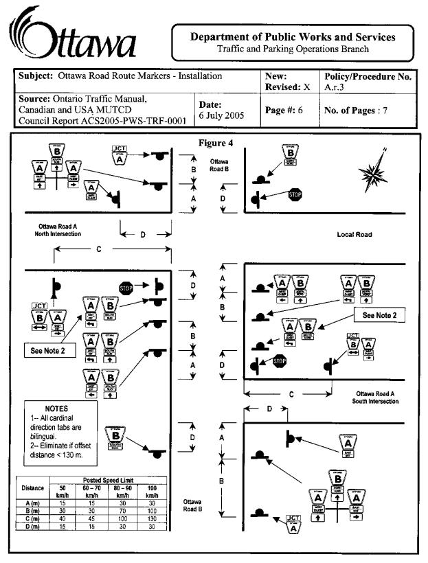
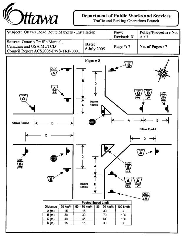
Annex 1 City of Ottawa Route Designation and Ottawa Road Route Marker Policy
DISPOSITION
Staff will change the on-street route market signage in accordance with this Policy, as resources permit. Similarly, adjustments to any City maps will be made in conjunction with routine updates.
Staff will continue to consult with MTO to ensure that the City of Ottawa Route Designation and Ottawa Road Route Marker Policy is applied in a consistent manner at provincial freeway interchanges.
ANNEX 1