|
1. OFFICIAL PLAN AND ZONING - 15 and 81 COLONNADE ROAD NORTH
plan officiel et zonage - 15 et 81, chemin colonnade
nord
|
Committee recommendations AS AMENDED
That Council:
1.
Approve an amendment to the City
Council Approved Official Plan for the lands at 15 and 81 Colonnade Road North
as shown in Document 1 and detailed in Document 3.
2. Approve
an amendment to the former City of Nepean Zoning By-law to change the zoning
for the lands at 15 and 81 Colonnade Road North as shown in Document 4 and detailed
in Document 5 as amended according to the recommendations articulated in
Table 1 of the Edgington report.
Recommandations MODIFIéES du Comité
Que le Conseil :
1. approuve une modification au Plan
officiel approuvé par le Conseil municipal pour les terrains du 15 et du 81,
chemin Colonnade Nord comme il est indiqué dans le Document 1 et expliqué dans
le Document 3.
2. approuve une modification au Règlement
de zonage de l’ancienne Ville de Nepean en vue de changer la désignation de
zonage des terrains 15 et 81, chemin Colonnade Nord comme il est indiqué dans
le Document 4 et expliqué dans le Document 5, tel que modifié
conformément aux recommandations formulées au tableau 1 du rapport Edgington.
Documentation
1. Deputy City Manager's report (Planning
and Growth Management) dated
10 November 2005 (ACS2005-PGM-APR-0185).
2. Table 1 of report entitled Planning
Rationale for Site Specific Development - Alternatives to the Ashcroft Rezoning
Proposal for 15 and 81 Colonnade Road, prepared by B. Edgington on behalf
of the General Burns Community Association follows the staff report (Edgington
report held on file with the City Clerk).
3. Extract
of Draft Minute, 22 November 2005.
Report to/Rapport au :
Planning and Environment Committee
Comité de l'urbanisme et de
l'environnement
and Council / et au Conseil
10 November 2005 / le 10 novembre 2005
Submitted by/Soumis par : Ned Lathrop, Deputy City Manager/
Directeur municipal adjoint,
Planning and Growth Management/Urbanisme et Gestion de la croissance
Contact
Person/Personne ressource : Karen Currie, Manager
Planning and Infrastructure
Approvals/Approbation des demandes d’aménagement et d’infrastructure
(613) 580-2424 x28310, karen.currie@ottawa.ca
|
|
Ref
N°:
ACS2005-PGM-APR-0185
|
|
SUBJECT:
|
OFFICIAL PLAN AND ZONING - 15 and 81
COLONNADE ROAD NORTH (D01-01-05-0003 & d02-02-05-0016)
|
|
|
|
|
OBJET :
|
Plan
officiel et zonage - 15 et 81, chemin colonnade nord (D01-01-05-0003 & D02-02-05-0016)
|
REPORT RECOMMENDATIONS
That the Planning and Environment Committee recommend that Council:
1. Approve an amendment to the City Council Approved Official Plan
for the lands at 15 and 81 Colonnade Road North as shown in Document 1 and
detailed in Document 3.
2. Approve an amendment to the former City of Nepean Zoning By-law to
change the zoning for the lands at 15 and 81 Colonnade Road North as shown in
Document 4 and detailed in Document 5.
RECOMMANDATIONS DU RAPPORT
Que le Comité de
l’urbanisme et de l’environnement recommande au Conseil :
1. d’approuver
une modification au Plan officiel approuvé par le Conseil municipal pour les
terrains du 15 et du 81, chemin Colonnade Nord comme il est indiqué dans le Document
1 et expliqué dans le Document 3.
2. d’approuver
une modification au Règlement de zonage de l’ancienne Ville de Nepean en vue de
changer la désignation de zonage des terrains 15 et 81, chemin Colonnade Nord
comme il est indiqué dans le Document 4 et expliqué dans le Document 5.
BACKGROUND
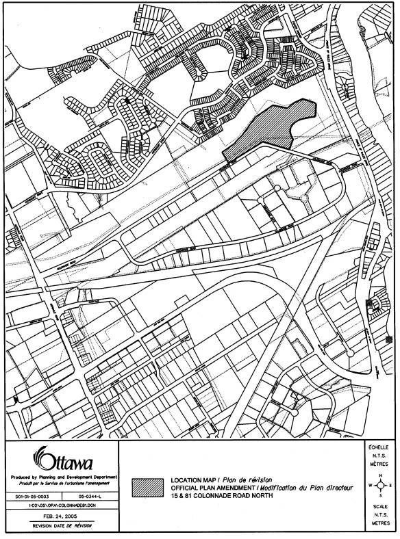
The
subject property is located on the north side of Colonnade Road North, adjacent
to the Colonnade Business Park. It is a
vacant site with an area of 8.7 hectares.
A location map is attached as Document 1. To the immediate south of the site, across Colonnade Road, is the
Colonnade Business Park which contains a mix of office, light industrial, and
sample/showroom uses. To the west are City owned soccer fields. To the north and east is City open space
consisting of Nepean Creek with a recreational pathway running along the top of
bank and stormwater management facilities. Further to the north, across the
Nepean Creek valley, are existing low density residential uses in the
communities of Fisher Glen and Carleton Heights.
Development
Proposal
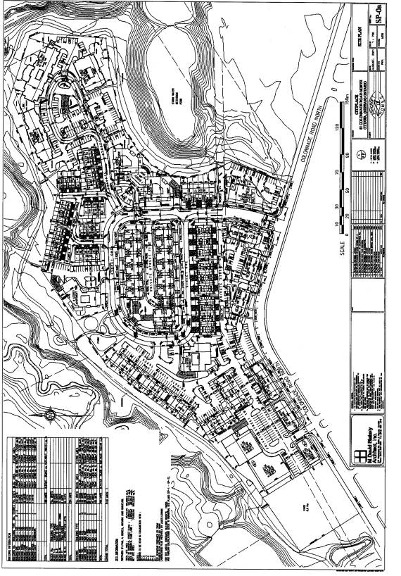
The
proponent has prepared a conceptual site plan for the proposed development in
support of the applications (Document 2).
The plan proposes a compact, mixed use development of office, retail and
residential uses. Proposed uses
adjacent to Colonnade Road are a series of three storey buildings with office
or retail uses occupying the ground floor and apartment units occupying the
upper two floors. A proposed public
street that forms a "P" loop provides services and frontage for the
parcels to the interior of the
property. Several private streets
branch off of the public street. A
series of blocks are proposed to be developed that will include a range of
housing types, either in freehold or
condominium ownership. Approximately
1100 residential units are proposed consisting of several low, medium and high
rise apartments, stacked townhouse units, back-to-back townhouse units and
conventional street townhouse units.
The development will have varied building heights and densities. Some of the housing units will have
underground parking while others will have surface parking or parking spaces in
garages. Some of the buildings will
accommodate retirement units. Private
amenity space will be provided with each cluster of residential development.
Two public parks are also proposed.
An
application for Plan of Subdivision Approval
has also been submitted along with the applications to amend the
Official Plan and Zoning By-law. As the Ward Councillor has removed Delegated
Authority approval for the subdivision application, a separate report dealing
with the subdivision application and containing the draft plan conditions has
been prepared and will be brought forward to Planning and Environment Committee
at the same time as the subject report.
Further details of the site's development will be dealt with through the
Site Plan Control applications for the blocks at a later date.
Purpose
of the Official Plan and Zoning Amendment Proposal
The
purpose of the Official Plan Amendment is to amend Section 4.8.7, Land-Use
Constraints Due to Aircraft Noise, of the City Council Approved Official Plan,
as it applies to the subject lands. The
intent is to allow residential uses within the Ottawa Airport Operating Influence
Zone currently shown on Schedule K.
The
proponent has requested that the lands be rezoned to permit mixed use,
residential and park uses which reflect the proposed plan. The application also requests approval to
remove the Holding provision on the basis that a Traffic Impact Study and a
draft road infrastructure improvements agreement has been submitted. The Zoning By-law Amendment application also
seeks to remove the Airport Operating Influence Overlay Zone applying to the
site on the basis of new noise contours that project lower levels of airport
related noise.
DISCUSSION
City
Council Approved Official Plan
The
City Council Approved Official Plan designates the property as General Urban
Area. This designation permits all
forms of housing, employment, shopping, service, industrial, park and natural
areas, entertainment and institutional uses.
Former
Regional Official Plan
The
Regional Official Plan designation for this property is General Urban Area and
the policies are similar to those found in the City Council Approved Official
Plan. A range of residential uses and
non-residential uses are permitted.
Former
City of Nepean Official Plan
The subject property is
designated Business Park in the former City of Nepean Official Plan. The purpose of this designation is to
provide for both traditional industrial and current business park uses. A range of non-residential uses are
permitted such as light industrial, office, institutional, business and
personal service uses, and convenience stores.
Due to there being no
appeals to the City Council Approved Official Plan with respect to the subject
lands and based on the submission date for these applications, the new Official
Plan prevails and will be used in the evaluation of the subject proposal.
Existing Zoning
The current Zoning
By-law zones the lands Industrial Business Campus - MBC(H) Blk 6. This zoning allows a range of business park
related uses including uses such as a bank, business office, light assembly and
production, multiple occupancy industrial building, and restaurant. The zone applies a maximum building height
is 11.5 m and the maximum floor area ratio is 0.4. Removal of the Holding provision is conditional upon the
submission and approval of a Traffic Impact Study, an agreement between the
City and the owners of the subject lands regarding cost sharing and
implementation of a schedule for construction of road infrastructure
improvements generated by development and submission and approval of a site
plan application to the satisfaction of the City. The Zoning By-law also
applies an Airport Operating Influence Overlay Zone which specifically
prohibits noise sensitive land uses.
Proposed
Official Plan Amendment
The
site is within the Airport Operating Influence Zone in the City Council
Approved Official Plan, one of two zones designated in the Plan to identify
areas where land use and future development is constrained by aircraft
noise. New residential uses are
considered a noise-sensitive land use and are not permitted in this zone. The boundaries of these zones are based on
the projected levels of noise around the airport resulting from current and
future airport operations. Federal
guidelines for land use have been based on two measures of projected noise, the
Noise Exposure Forecast (NEF) and the Noise Exposure Projection (NEP) that can
be depicted as noise contours around the airport. The boundary of the Airport Operating Influence Zone is based on
the 30 NEF and NEP contour, whichever is more restrictive. A composite of the 30 NEF/NEP contour has
been created and mapped against physical features on the ground, to define the
boundary of the Airport Operating Influence Zone and thus make the policy more
readily interpreted and applied.
Since
the adoption of the Official Plan by City Council in May 2003, the NEF and NEP
contours were revised by the Ottawa International Airport Authority in 2005 to
reflect updated projections of future airport activity and associated noise.
The subject site is outside both the revised 25 and the 30 NEF and NEP
contours. The work of mapping the
revised contours against physical features to amend the boundary of the Airport
Operating Influence Zone and other designations on Schedule K has been
completed. A comprehensive Official Plan amendment has been prepared and is
being brought to Committee and Council concurrently with the subject report.
Although
the comprehensive OPA will accomplish what the site specific Official Plan
Amendment will do, the site specific OPA is still being recommended as the
applicant has requested the separate OPA in case the comprehensive OPA is not
approved or appealed which would result in a delay in the proposed development.
The site will continue to be within the Airport Vicinity Development Zone,
where the Ottawa International Airport Zoning regulations apply and affect such
matters as the location and height of objects on lands near the airport.
If
the current airport noise constraint did not apply to the site, an Official
Plan amendment would not be required and the development applications for the
site would be evaluated in accordance with the General Urban Area
policies. The General Urban Area
designation encourages the development of a full range and choice of housing
types, densities and sizes for a variety of demographic profiles, in
combination with conveniently located employment, service, leisure,
entertainment and institutional uses. Official Plan policies support
intensification, like the proposed development, in a manner that enhances and
complements the desirable characteristics and ensures the long-term vitality of
the existing surrounding community. The proposed development is a
well-designed, mixed-use community offering a wide range of housing types and
forms of tenure, plus employment, commercial space for uses such as shops,
restaurants, day-care centres and medical facilities, and active and passive
parkland space. Clustering of
neighbourhood scale commercial services as part of the development with good
pedestrian connections, make the development more complete and walkable. It will be an integrated development with
the opportunity to work, live, shop and play in the same general area.
Evaluation
of Zoning Proposal
Compatibility and Diversity
When
considering a proposed change of land use, the compatibility of the proposed
use must be evaluated. The concept plan
for the development of the site takes
into consideration the pattern of the surrounding area. The adjacent open space containing the creek
valley, stands of mature trees and stormwater retention facilities provide a
wide buffer between the residential community to the north and also housing on
the east side of Prince of Wales Drive.
Along the Colonnade Road frontage, the use of three storey buildings
with office and showroom uses on the ground floor and apartments above provide
a transition between the business park across the street and the residential
uses proposed for the interior of the subject property. The use of two and three storey buildings
towards Colonnade Road with high rise apartments planned farthest from
Colonnade Road also provides a transition and separation space with the one and
two storey buildings on the south side of Colonnade Road. The addition of a sidewalk and street trees
along the north side of Colonnade Road, adjacent to the development, along with on-site parking areas being
planned to be at the side or rear of buildings, will provide a pedestrian
friendly, attractive streetscape.
This
proposal will contribute to the diversity of the land use and activity in the
area. As the surrounding community does
not contain a wide range of housing types to meet the needs of all ages,
incomes and life circumstances, this development will contribute to the
diversity of the area by offering a choice of housing. It will inject new investment into an area
that contains mainly non-residential uses which may result in additional future
investment as the area reinvents itself as a mixed-used neighbourhood. As well, the provision of two public parks
as part of the proposed development, meets an identified need for recreational
space for future residents as well as providing existing employees and
residents of the area with additional park space. Finally, the proposed development can to be supported by existing
infrastructure, including sewer, water and a major collector road, meeting a
major underlying principle in the Official Plan of optimizing existing
infrastructure wherever possible.
Transportation
In
support of this application, a Traffic Impact Study was prepared and it
concluded that the proposed residential-based development is compatible with
the existing business park development from the perspective of maximizing the
directional capacity of the surrounding transportation network. In peak periods, traffic from the subject
development will travel mainly in
opposite directions from that of traffic associated with the business park. The
study indicates that the surrounding roadways and intersections which would
serve the development, are operating at capacity during peak periods, but the
addition of the traffic from the proposed development would only slightly add
to traffic volumes. On the basis of
full build-out by a horizon year of 2013 and assuming stable growth in
background traffic, the proposed development is estimated to contribute 5% and
10% to projected traffic volumes on Merivale Road and Prince of Wales Drive,
respectively, at this horizon. It is
noteworthy, however, that these contributions would be approximately halved (3%
and 5%) if full build-out of the proposed development occurred instead over 15
years, which is considered more realistic given local housing sales forecasts.
Some
intersection modifications are recommended such as the addition of a second
westbound left-turn lane on Colonnade Road onto southbound Merivale Road. A cost-sharing agreement between the City
and the owners of the subject lands as well as two other parcels of land yet to
be developed on the north side of Colonnade Road, is to be completed and approved
by the City prior to the Holding zone being lifted. Three OC Transpo routes
currently operate on Colonnade Road in the vicinity of the subject lands. Additional routes may have to be added after
project build out. Finally, possible construction of the proposed east-west
light rail line along the existing CN rail corridor just south of the business park, with possible stations at the
western and eastern limits of the business park, is seen as a positive feature
for this development from a transportation perspective.
Pedestrian Network
With respect to
integration of the development with existing pedestrian and bicycle networks,
the proposed pedestrian network identified within the site plan provides good
connection to the existing recreational pathway system situated to the north
and east of the site. The provision of
a sidewalk on Colonnade Road is proposed along the site's frontage. Sidewalks are also planned for both sides of
the public street from where it connects with Colonnade Road and to the inside
portion of the "P" loop that is adjacent to the terrace homes. A need has been identified for a link to the
Fisher Glen community to the north to allow future residents to access the
schools and other community facilities located in that community. Conceptually, this could be easily
accomplished by the installation of a bridge structure across Nepean Creek
immediately north of the proposed development and in the vicinity of Coolspring
Crescent in Fisher Glen. This
enhancement to the existing pathway network is also viewed as being beneficial
to the existing residents located to the north to allow them better access to
the business park and surrounding recreational pathways and parkland. Details with respect to location and timing
of the bridge will be confirmed through the subdivision approval process,
however, the proponent will be responsible for the full cost of the
installation of the bridge.
Environmental
Studies
The
adjacent City-owned property in which is located the Nepean Creek is designated
as an Urban Natural Feature on Schedule B to the Official Plan. As the subject property is within 30m of an
Urban Natural Feature, an Environmental Impact Study is required. The approach taken by the environmental
consultants was to identify the most important features on the property that
could be incorporated into the development in keeping with the City's design
with nature policy and to ensure that no negative impact occurs on features and
functions of the existing Urban Natural Feature on the adjacent property. A Preliminary Tree Preservation Plan has
also been submitted which includes an assessment of the quantity and quality of
tree cover and opportunities for additional plantings. The environmental consultants noted that
the most mature trees in the area are either located off-site along the banks
of the Nepean Creek or on-site along the perimeter of the property where the
Tree Preservation Plan included the retention and preservation of these
stands. The environmental consultants
concluded that use of mitigative measures, environmentally sensitive
construction techniques and implementation of the recommendations in the Tree
Preservation Plan will minimize impacts to the retained forest blocks and
vegetation outside the development envelope. Details and implementation of the
recommendations from the environmental reports will be done through the
subdivision and site plan approval processes.
Details
of Recommended Zoning
The
Zoning By-law amendment application requests that the property be zoned to
permit the proposed development and that special provisions, reflective of the
proposed concept plan, be applied to the site. The application also seeks to
have the Airport Operating Influence Overlay Zone removed from the site on the
basis of the new NEF and NEP noise contours that project lower levels of
airport related noise being experienced on-site. Finally, the application also requests that the Holding provision
be removed on the basis that a traffic impact study and cost sharing proposal
have been submitted.
Staff are recommending
three main zones be applied to the site, as shown in Document 4 and detailed in Document 5. Firstly, the two proposed public parks
located on the western edge and north central area of the property will be
zoned Parks and Recreation (Public).
Secondly, the areas which will contain the mixed use buildings located
along Colonnade Road and in the north west corner of the property will be zoned
Commercial Mixed Use - CMU (H). Within this zone there will be two sub-zones
(special provisions) in order to control building height and density and allow
for a reduced parking standard for business office of 1 space per 50 m2 of
gross floor area. Staff are in support
of the reduced parking standard for business office in this location as it has
been approved for other office developments in the area and additional
on-street parking will be available on Colonnade Road.
The areas containing the
residential uses will be zoned primarily Residential Seventh Density - R7(H)
with a small area for a block of street townhouses being zoned Residential
Fifth Density - R5(H). Within the R7
(H) zone, there are six special provision zones which will regulate land use
(multiple attached or apartments), density, height, building coverage and
setbacks.
As requested, staff are
recommending that the Airport Operating Influence Overlay Zone be removed for
reasons previously mentioned. However, it is recommended that the Holding
provision remain on the property until such time as the cost-sharing agreement
for required road modifications is
resolved among all the interested parties.
Conclusion
It is staff’s opinion
that the subject proposal to amend the Official Plan and Zoning By-law be
approved as the proposed development is suitable and appropriate for the area
as it is compatible with, and will have no negative impact on surrounding uses.
The rezoning proposal conforms to Official Plan policies and will contribute to
the City of Ottawa's intensification and residential housing objectives.
CONSULTATION
Notice
of this application was carried out in accordance with the City’s Public
Notification and Consultation Policy. The Ward Councillor is aware of this
application and the staff recommendation. Correspondence and phone calls from
the public, both in support and against the proposal, were received including
from area residents, area businesses, and the General Burns Community
Association. Comments were also
received from several technical agencies.
An open house (March 8/05) and community meetings (May 17/05, September
6/05) were held with the applicant, Ward Councillor and staff in attendance. A
community meeting was also held on October 18/05 in the adjoining ward, Ward 16
(River). As well, staff attended separate meetings with the Councillor and
representatives of the Community Association.
A summary of the main issues identified through letters, email and the
community meeting, is attached in Document 5.
APPLICATION
PROCESS TIMELINE STATUS
The
applications were not processed within the “On-Time Review” timeframe
established for the processing of Official Plan and Zoning By-law Amendment
applications due to the detail in the submission of required studies, the
complexity and controversial nature of the subject applications.
FINANCIAL IMPLICATIONS
N/A
SUPPORTING DOCUMENTATION
Document
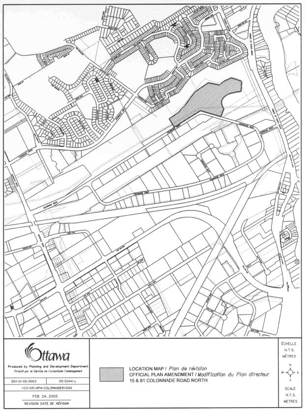
1 Location Map
Document 2 Conceptual Site Plan
Document
3 Draft Official Plan Amendment to
the City Council Approved Official Plan
Document
4 Proposed Zoning Map
Document
5 Details of Recommended Zoning
Document 6 Consultation Details
DISPOSITION
Department
of Corporate Services, Secretariat Services to notify the owner (Ashcroft Homes
, 18 Antares Drive, Ottawa, ON, K2E 1A9), applicant (Dave Krajaefski, Trow
Associates Inc., 154 Colonnade Road South, Ottawa, ON. K2E 7J5) All Signs, 8692
Russell Road, Navan, ON K4B 1J1 and the Manager of Assessment, Department of
Corporate Services of the City Council’s decision.
Planning
and Growth Management Department to prepare the implementing by-laws, forward
to Legal Services Branch and undertake the statutory notification.
Department
of Corporate Services, Legal Services Branch to forward the implementing
by-laws to the City.
Official Plan Amendment XX /Modifications du Plan
directeur
To the
Official Plan of the City of Ottawa
Land use
Utilisation du sol
DRAFT OFFICIAL PLAN AMENDMENT
AMENDMENT No. XX TO THE CITY COUNCIL APPROVED OFFICIAL PLAN
INDEX
COMPONENTS
PART A THE PREAMBLE
PART B –
THE AMENDMENT
1.0
Introduction
2.0
Details
3.0
Implementation
COMPONENTS
PART A - THE PREAMBLE does not constitute part of this
amendment.
PART B - THE AMENDMENT,
consisting of the following text constitutes Amendment No. XX to
the City of Ottawa Council Approved Official Plan.
PART A - THE PREAMBLE
1.0 PURPOSE:
2.0 LOCATION
The subject site is located on the
north side of Colonnade Road North and is known municipally as 81 and part of
15 Colonnade Road North, as shown in the attached location map. The site is vacant and has an area of
approximately 8.7 hectares. To the
immediate south of the site, across Colonnade Road is the Colonnade Business
Park, a mix of office, light industrial, showroom and limited retail uses. To
the west is City parkland consisting of soccer fields. To the north and east are Nepean Creek and
stormwater management facilities owned by the City.
3.0 BASIS
The purpose of the proposed Official Plan Amendment is to
allow the property to be developed with residential uses. Approximately 1100
residential units are proposed consisting of several low, medium and high rise
apartment buildings and multiple attached dwellings. Office and retail
development is also proposed. The
subject property is designated as General Urban Area in the City Council
Approved Official Plan. Generally, this designation permits all types of
densities of housing, employment, shopping, service, industrial, park and
natural areas, entertainment and institutional uses.
However, the site is within the Airport Operating
Influence Zone on Schedule K of Official Plan, one of two zones designated in
the Plan to identify areas where land use and future development is constrained
by aircraft noise. The boundaries of
these zones are based on the projected levels of noise around the airport
resulting from current and future airport operations. Federal guidelines for land use have been based on two measures
of projected noise, the Noise Exposure Forecase (NEF) and the Noise Exposure
Projection (NEP) that can be depicted as noise contours around the
airport. The boundary of the Airport
Operating Influence Zone is based on the 30 NEF and NEP contour, whichever is
more restrictive. A composite of the 30
NEF/NEP contour has been created and mapped against physical features on the
ground, to define the boundary of the Airport Operating Influence Zone and thus
make the policy more readily interpreted and applied. The 25 NEF and NEP contours, as well as the 35 NEF and NEP
contours, are also used to define areas subject to noise constraints.
The NEF and NEP contours were
revised by the Ottawa International Airport Authority in 2005 to reflect
updated projections of future airport activity and associated noise. The
subject site is outside both the revised 25 and the 30 NEF and NEP
contours. The work of mapping the
revised contours against physical features to amend the boundary of the Airport
Operating Influence Zone and other designations on Schedule K has just been
completed. A comprehensive Official Plan amendment has been prepared and
is being brought to Committee and Council concurrently with the subject report.
Although the comprehensive OPA
will accomplish what the site specific Official Plan Amendment will do, the
site specific OPA is still being recommended as the applicant has requested the
separate OPA in case the comprehensive OPA is not approved or appealed which
would result in a delay in the proposed development.
The site will continue to be
within the Airport Vicinity Development Zone, where the Ottawa International
Airport Zoning regulations apply and affect such matters as the location and
height of objects on lands near the airport.
An
amendment to the Zoning By-law and Subdivision Application are being reviewed
concurrently with this Amendment. The
proposed Zoning amendment will provide the tools to establish the setbacks and
limit the size of the development as well it will remove the property from the
“Airport Operating Influence Overlay Zone”.
PART B - THE AMENDMENT
1. INTRODUCTION
All
of this part of the document entitled Part B - The Amendment, consisting of the following text constitutes Amendment No. XX
to the City Council Approved Official Plan.
2. DETAILS
That the
City Council Approved Official Plan is hereby amended as follows:
1.
Subsection 4.8.7. of the City Council Approved Official Plan
is hereby amended by adding the following new policy 10 at the end of Policy 9:
“Notwithstanding the
policies of Section 4.8.7, residential development and other noise-sensitive
uses are permitted on the property known municipally as 81 and part of 15
Colonnade Road North and no noise studies as described in this Section are
required. This policy anticipates
revision of the boundary of the AOIZ on Schedule K, based on revised
projections of aircraft noise in 2005.
These projections indicate that the subject site is outside the revised
25 NEF and NEP contours. The AOIZ
Airport Zoning regulations will still apply.”
2. “The subsequent policies are renumbered as
required.”
3. IMPLEMENTATION
The implementation of this
Amendment to the Official Plan document shall be in accordance with the
respective policies of the Official Plan of the City of Ottawa.
LOCATION MAP
DOCUMENT 4
PROPOSED ZONING MAP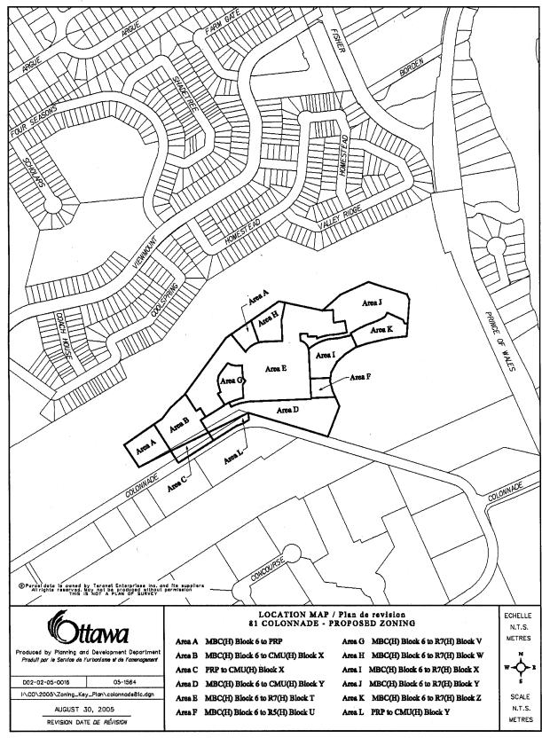
Document 5
DETAILS
OF RECOMMENDED ZONING
Zoning Details
1. A new CMU
exception zone be created for Area B and Area C on Document 1 including the
following requirements:
a) dwellings
multiple attached and dwellings apartment will not be permitted on the ground
floor;
b) a
day nursery will be considered as a primary use
c) cinema/theatre,
garden centre, outdoor vehicle or merchandise sales, refreshment vehicle and
special event outdoor sales will not be permitted
d) the maximum floor area ratio be 2.4
e) the minimum yard front be 3.0 metres
f) the minimum yard side be 1.5 metres
g) the minimum yard rear be 6.0 metres
h) the parking requirements for business office
will be 1 space per 50 m2 of gross floor area.
i)
the maximum building height be 8 storeys.
j) the minimum parking requirements will be 1.0
parking space per dwelling unit plus
0.25 parking spaces per dwelling unit for visitor parking.
2. A new CMU exception zone be created for
Area D and Area L on Document 1 including the following requirements:
a)
dwellings multiple attached and dwellings apartment will not
be permitted on the ground floor;
b) a
day nursery will be considered as a primary use
c) cinema/theatre,
garden centre, outdoor vehicle or merchandise sales, refreshment vehicle and
special event outdoor sales will not be permitted
d) the minimum yard front be 3.0 metres
e) the minimum yard side be 1.5 metres
f) the minimum yard rear be 6.0 metres
g) the parking requirements for business office
will be 1 space per 50 m2 of gross floor area.
h) the maximum building height be 3 storeys.
i) the minimum parking requirements will be 1.0
parking space per dwelling unit plus
0.25 parking spaces per dwelling unit for visitor parking.
3. A new R7 exception zone be created for
Area E on Document 1 including the following requirements:
a) For both dwellings multiple attached
and dwellings apartment:
i) the minimum lot area will be 4200
square metres
ii) the minimum lot frontage will be 30
metres
iii) the maximum lot coverage will be 50%
iv) the minimum building main spacing will
be 3.0 metres
b) For dwellings multiple attached:
i) the minimum yard front will be 3.0
metres
ii) the minimum yard rear will be 1.5
metres for the back-to-back units and 5.0 metres in all other cases
iii) the minimum yard side will be 1.5
metres
c) where a dwelling multiple attached
abuts a street where there is not a
sidewalk the
required parking spaces will have a minimum length of 4.5
metres
d) the
parking requirements for dwellings multiple attached will be 1.5 spaces per
dwelling unit including visitor parking
e) the
dwelling units can later be legally severed or divided without each dwelling
unit having to meet the zone requirements as long as the original lot continues
to meet the overall requirements
4. A
new R5 exception zone be created for Area F on Document 1 including the
following requirements:
a) The
only permitted use will be dwellings multiple attached
b) the maximum lot coverage will be 60%
c) the
minimum yard rear will be 6.0 metres
5. A
new R7 exception zone be created for Area G on Document 1 including the
following requirements:
a) the
only permitted use will be dwellings apartment
b) the minimum lot area will be 3100
square metres
c) the minimum lot frontage will be 40
metres
d) the maximum density will be 195 units
per hectare
e) the minimum yard front will be 6.0
metres
f) the
minimum yard rear will be 12.0 metres
g) the
minimum yard side will be 7.5 metres
h) the
maximum building height will be 19.0 metres
i) the
minimum parking requirements will be 1.0 parking space per dwelling unit plus
0.25 parking spaces per dwelling unit for visitor parking
6. A
new R7 exception zone be created for Area H on Document 1 including the
following requirements:
a) the
only permitted use will be dwellings apartment
b) the minimum lot area will be 3300
square metres
c) the minimum lot frontage will be 30
metres
d) the maximum density will be 240 units
per hectare
e) the minimum yard front will be 6.0
metres
f) the
minimum yard rear will be 7.5 metres
g) the
minimum yard side will be 4.5 metres
h) the
maximum building height will be 25.0 metres
i) the
minimum parking requirements will be 1.0 parking space per dwelling unit plus
0.25 parking spaces per dwelling unit for visitor parking
7. A
new R7 exception zone be created for Area I on Document 1 including the
following requirements:
a) the
only permitted use will be dwellings apartment
b) the minimum lot area will be 4600
square metres
c) the minimum lot frontage will be 30
metres
d) the maximum density will be 375 units
per hectare
e) the maximum lot coverage will be 45%
f) the minimum yard front will be 6.0
metres
g) the
minimum yard rear will be 5.5 metres
h) the
minimum yard side will be 4.5 metres
i) the
maximum building height will be 25.0 metres
j) the
minimum parking requirements will be 1.0 parking space per dwelling unit plus
0.25 parking spaces per dwelling unit for visitor parking.
8. A
new R7 exception zone be created for Area J on Document 1 including the
following requirements:
a) the
only permitted uses will be dwellings apartment and retirement home
b) the
minimum lot frontage will be 30.0 metres measured along the lot line front.
d) the
minimum yard front will be 6.0 metres
e) the
minimum yard rear will be 5.5 metres
f) the
minimum yard side will be 5.5 metres
g) the
maximum building height will be 31.0 metres
h) the
minimum parking requirements will be 1.0 parking space per dwelling unit plus
0.25 parking spaces per dwelling unit for visitor parking.
i) the
R7 Block Y zone and the adjacent R7 Block Z zones will be considered as one lot
for parking requirement purposes
9. A
new R7 exception zone be created for Area K on Document 1 including the
following requirements:
a) the
only permitted use will be dwellings apartment
b) the
minimum lot frontage will be 0 metres as long as the lot has access to a public
street through a private street
c) the maximum
density will be 345 units per hectare
d) the minimum
yard front will be 6.0 metres
e) the minimum
yard rear will be 5.5 metres
f) the minimum
yard side will be 5.5 metres
g) the maximum
building height will be 50.0 metres
h) the
minimum parking requirements will be 1.0 parking space per dwelling unit plus
0.25 parking spaces per dwelling unit for visitor parking.
i)
the R7 Block Z zone and the adjacent R7 Block Y zones will be
considered as one lot for parking requirement purposes
j) the
minimum lot area will be 4400 sq. m
10. Schedule B9
will be amended as follows:
Area A on
Document 1 be rezoned from MBC(H) Block 6 to PRP
Area B on Document 1 be rezoned
from MBC(H) Block 6 to CMU(H) Block X
Area C on Document 1 be rezoned
from PRP to CMU(H) Block X
Area D on Document 1 be rezoned
from MBC(H) Block 6 to CMU(H) Block Y.
Area E on Document 1 be rezoned
from MBC(H) Block 6 to R7 (H) Block T.
Area F on Document 1 be rezoned
from MBC(H) Block 6 to R5(H) Block U.
Area G on Document 1 be rezoned
from MBC(H) Block 6 to R7 (H) Block V.
Area H on Document 1 be rezoned
from MBC(H) Block 6 to R7 (H) Block W.
Area I on Document 1 be rezoned from MBC(H) Block 6 to R7 (H) Block X.
Area J on Document 1 be rezoned
from MBC(H) Block 6 to R7 (H) Block Y.
Area K on Document 1 be rezoned from MBC(H) Block 6 to R7 (H) Block Z.
Area L on Document 1 be rezoned
from PRP to CMU(H) Block Y.
Remove Airport Operating Influence
Overlay Zone from the subject properties
as shown in Document 1.
11. In all of the
above noted exception zones, Section 13.3 will not apply.
OFFICIAL PLAN AND ZONING - 15 AND
81 COLONNADE ROAD NORTH
PLAN OFFICIEL ET ZONAGE - 15 ET 81,
CHEMIN COLONNADE NORD
ACS2005-PGM-APR-0185 BELL-SOUTH
NEPEAN (3)
Ms. Karen Currie, Manager,
Development Approvals, Planning and Infrastructure Approvals Branch, Planning and
Growth Management Department (PGM), introduced Ms. Louise Sweet-Lindsay,
Planner, Development Approvals, Planning and Infrastructure Approvals Branch,
who provided the Committee with an overview of the staff report. A copy of the PowerPoint presentation is
held on file with the City Clerk.
Councillor Gord Hunter sought
clarification about a proposed technical amendment to Item 5, Aircraft Noise
Constraints, as it was his belief there was consistency between the Official
Plan and Zoning for Colonnade Rd and the airport item. At issue was the staff proposal to
"delete the area at Colonnade Rd from the Airport Operating Influence Zone
(AOIZ)". Councillor Hunter questioned
whether this was not an error, since this would remove the Colonnade Rd north
lands away from the AOIZ and from the Airport Vicinity Development Zone (AVDZ)
causing a "hole" with airport influence zones around it.
Mr. Myles Mahon, Planner, confirmed
that the requested technical amendment to Item 5 was incorrect and that the
original recommendation was correctly worded.
The following public delegations
were heard:
Representatives of the General
Burns Community Association (GBCA) led by Mr. Michael Koch, P. Eng (Civil),
who introduced his team members: Mr. Barry Edgington, former Director, Plans
Administration Branch, RMOC Planning Department, Dr. Terry McIntyre, PhD,
Environmental Science, Dr. Pierre Lavoie, PhD, Electrical Engineering, Gord
Jenkins, former Director and Real Property Manager, Public Works Canada and
Scott McEwen, Director, GBCA.
Delegation members provided detailed information to back up their
rationale for not supporting the Ashcroft proposal:
·
the
loss of a significant portion of an important natural feature, the Nepean Creek
(Mr. Koch);
·
the
huge gaps in environmental assessment, the ecological risks and confounding
environmental factors (Dr. McIntyre);
·
planning
and process flaws (Mr. Edginton);
·
an
unsupportable traffic plan (Mr. McEwen).
Mr. Koch expressed the GBCA's belief that critical and necessary
information is incomplete and/or missing, in order for the Committee to make a
well-informed decision. For this
reason, he requested that the Committee defer consideration of the item until
the following is available:
·
a
proper Environmental Impact Study;
·
the
recommendations of the Urban Natural Areas Environmental Evaluation Study
(UNAEES) for the protection of sites with high or moderate ecological
significance;
·
the
City of Ottawa draft Intensification By-law;
·
the
Stormwater Drainage Management Strategy;
·
a more
comprehensive traffic management study.
Mr. Koch said that, in the event the
Committee believes it has enough information to approve the proposal, it should
consider restricting development to areas not impacted by the forthcoming
UNAEES and adopt the GBCA's alternate view of the development, as articulated
by the planning consultant, Mr. B. Edgington.
Mr. Edgington presented his report
entitled Planning Rationale for Site Specific Development - Alternatives to the
Ashcroft Rezoning Proposal for 15 and 81 Colonnade Road (on file with the City
Clerk). In this document, Mr. Edginton
makes four (4) recommendations;
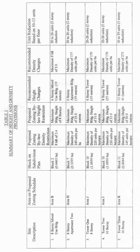
1. reductions in maximum building heights
in Areas B, H, J and K as detailed in Table 1.
2. referral of the revised height and
density restrictions back to planning staff for the required adjustments.
3. deferral of the subdivision plan
(Agenda Item 2) until the zoning revisions have been fully considered.
4. Consideration of further reductions in
density to bring the project more in line with density limits envisioned as per
the rezoning in 2000 of the property from "Institutional" to
"Industrial Business Campus".
Speaking to the last
recommendation, Mr. Edgington said consideration should be given to single
family, low-to-medium density on the ravine side, with higher densities on
Colonnade Rd North. He noted there are
provisions for 7 private roads and there may be future servicing and
maintenance problems as relates to snow clearing, maintenance of condominiums,
condominium associations and other matters that should be addressed.
The complete texts of the GBCA's and
Mr. Edgington's submissions are on file with the City Clerk .
In reply to a question from
Councillor Jan Harder, Mr. Koch said the material presented was recently
created and it was not presented beforehand because the GBCA’s preference is
still that the decision be deferred until environmental concerns are
addressed. The Councillor congratulated
the group for their work and said she appreciated their efforts.
Councillor Hunter asked for a staff
comment on the extensive use of private laneways in the proposed
development. Ms. Currie indicated there
would be site plan approval for individual blocks and that the City was looking
for alternative standards for public roads, with a view to having fewer roadway
and more yield on the property.
Councillor Hunter pointed out that, in the Tanglewood area, with its 300
units, there is spillover parking on neighbourhood roads. The proposed development, with its 1100
units and a preponderance of private
roadways would likely experience the same problems.
Councillor Harder wondered whether
the Rideau Valley Conservation Authority (RVCA) had raised any concerns about
environmental issues. Dr. McIntyre
responded by saying that conversations did occur between the RVCA and the
developers and that the former would have been interested in proposals to deal
with groundwater issues. He speculated
that, as relates to the absence of comment from OC Transpo, these agencies are
likely over-extended.
Paul Koch, Chair, Environmental
Advisory Committee, (EAC ) related the EAC's position, that
while in abstract terms the proposed development is an attractive one,
it is in the wrong location and poses serious concerns in its current
state. An EAC Motion from 8 September
2005 recommends that there be a restriction of 11.5 metres on building height,
that there be modelling of current and potential population to full build-out
of the area bounded by Hunt Club Rd, Baseline Rd, Merivale Rd and Prince of
Wales Dr to determine the cumulative impacts on traffic, public transit,
schools and other infrastructure and finally, that consideration be given to
designate all or a portion of any funds-in-lieu of parkland to support the
Poets Pathway project along the adjacent Nepean Creek. Mr. Koch concluded by urging the Committee
to support the recommendations of the GBCA and to heed the comments of groups
such as Canada's Capital Greenspace Alliance and the Ottawa Forests and
Greenspace Advisory Committee.
The complete text of the EAC's
presentation is on file with the City Clerk.
Chair Peter Hume asked why the
provisions of the holding zones were not used, to ensure capacity as the
project builds out. The holding zone
could be lifted when the traffic impact studies are completed. Ms. Currie replied that staff is dealing
with the existing restrictions imposed by the former City of Nepean.
Lee Farnsworth spoke in opposition to the
development, based on promises made and trust.
As a former Nepean Councillor and Chair of the Nepean Parks and
Recreation Committee, Ms. Farnsworth provided background information on the
site, culminating in 1999 with a proposal by the National Capital Commission
(NCC) and Public Works Canada for the re-development of the lands. A compromised was reached to the
satisfaction of all parties and promises were made to residents of the Fisher
Heights area. Ms. Farnsworth then
addressed the issue of traffic management and the continual build-up, noting
that Fisher Ave would take much of the diverted traffic. She added that development at the west end
of the lands or the lands on the other side of Merivale, currently owned by the
NCC, has not yet been addressed. She requested that the Committee either turn
down the proposal or defer it, expressing her belief it had been inappropriate
of the City to enter into an agreement with the developer without dealing with
the airport.
When asked by Councillor Harder for
additional comments on traffic issues, and on the fact that OC Transpo has not
commented on the proposed development, Ms. Farnsworth said traffic in the area
would worsen and traffic calming measures may need to be put in place. As to OC Transpo and the absence of an
east-west Transitway link, Ms. Farnsworth pointed out this was on the
"wish list" and development should not be based on this possibility.
Chris Hubbard said she was speaking for mothers
everywhere by expressing her concern with increased traffic and stress on
roadways. She said the area's traffic
problems must be addressed before any new development takes place. The current zoning's density and height
restrictions should not be overturned simply to accommodate the proponent. If allowed to build homes on Colonnade Rd,
Ascroft Homes should preserve the pathway and ensure the new homes do not
overshadow the existing ones. The
developer should be prepared to follow the zoning guidelines.
Iola Price, Chair, Ottawa Forests
and Greenspace Advisory Committee, spoke in opposition to the proposed development. To illustrate her points, Ms. Price used a
slide presentation and read from a prepared statement, both of which are held
on file with the City Clerk. Ms. Price
commented on the need for a passive, wooded park to be provided, given that 85%
of trees are already gone from the urban natural area. The comment about the site only containing
scrub vegetation is incorrect: it is a young, upland deciduous forest. Ms. Price also stated that she had expected
a better Tree Preservation Plan than the one submitted. She also averred that the clearing of land
before approval is unacceptable, and that the City needs a mechanism such as a
Tree Cutting By-law to address this situation.
Ms. Price felt there should be a well-defined buffer between the
existing path and the new development.
There should also be a 30-metre setback from the top of the ravine slope
for all buildings.
In reply to a question from
Councillor Diane Holmes, Ms. Sweet-Lindsay said that the tree protection plan
does specified which trees will be retained and this would be added to the site
plan approval.
Erwin Dreessen, Greenspace Alliance
of Canada’s Capital,
spoke in opposition to the proposal, referring to a prepared handout and
written comments, both of which are held on file with the City Clerk. He expressed strong support for the
recommendations put forward by the Environmental Advisory Committee and made
reference to the fact that there are serious issues of connectivity in the
proposed development.
William Watt stated his opposition to the
proposal, referring to a prepared statement held on file with the City
Clerk. He spoke about dumping and other
damage mostly in the vicinity of row house development and he asked that the
City not allow development along waterways.
He felt the proposed development would be particularly intrusive along
Nepean Creek. He also requested there
be parkland allocation within the development..
Ms. Carol Gutz, a resident of
Portland Park,
pointed out that the area has many traffic problems and is being asked to
accommodate more traffic. She felt that
the cumulative impacts of traffic were not being studied and she asked that the
proposal not be approved.
Al Speyers provided additional details about
the process of rezoning the lands from Institutional to Industrial Park by the
former City of Nepean in year 2000. He
made reference to events that followed the decision to turn down the
application, and he asked that the City reconsider the original rezoning of the
site.
Councillor Rick Chiarelli asked Mr.
Speyers to clarify whether he was asserting that the original rezoning was made
for non-planning reasons. Mr. Speyers
reiterated that the decision was made under duress. Councillor Chiarelli stated that, by definition, items discussed
at In Camera meetings cannot be planning principle matters, as this would be
illegal. The matters discussed dealt
with a real estate offer and the receiving of legal advice on the offer.
Robert Brocklebank, President,
Federation of Citizens’ Associations (FCA) indicated that the FCA raised concern about
the ease at which spot rezonings were being approved, seemingly just through
the use of the magic words "intensification" and "Official
Plan". In response, the FCA were
reassured that the existing zoning by-laws would be respected until a new
zoning by-law is in place. Mr. Brocklebank posited that the Colonnade Rd site
should be zoned as a business campus, with a maximum height restriction of 11
metres. He added that he failed to see
the urgency in rezoning this land, and why it shouldn’t proceed in accordance
with existing zoning.
Mr. Martin
Mudde is associated with the
Redeemer Christian High School and has concerns with the safety of students
having to cross the proposed development.
He would like to see the sidewalks, currently designed as partial, being
extended all the way to the School and the sports field.
Paul Rothwell, Director of Planning,
Ashcroft Homes
introduced Dave Krasjewski, independent Planner, and Ron Jack (Delcan). Mr. Rothwell stated that the time is now,
and the place is here, to approve City Place.
Once completed, it will be a self-sustaining village. The development fulfills the goals of the
Official Plan for mixed-use density and represents a gentle form of
intensification. Mr. Rothwell stated
that the required studies were rigorously done, by professionals respected in
their fields. A comprehensive plan for
reforestation will ensure City Place is a responsible neighbour. He admitted that some clearing had taken
place, mostly of buckthorn trees, but the City was advised that this would take
place.
Mr. Rothwell spoke about design
features that call for the controlled use of materials, textures and colours,
with 70,000 square feet of commercial retail space for 300 employees and a wide
variety of dwelling styles: terraced homes, upscale patio townhouses,
condominium units and full-service retirement suites. Out of the proposed 1100 dwellings, 400 are geared to seniors and
retirees and 40% of homes meet the criteria for affordability. At the anticipated build-out rate, the project
will take 10 to 15 years to complete.
With regard to adding additional
traffic to the area, Mr. Rothwell said there would be a signalized intersection
at the entrance and plenty of visitors parking. Ashcroft Homes contribute to the reconfiguration of the Merivale
Rd/Colonnade Rd intersection. The
Environmental Assessment process for the East/West link of the Transitway is
about to commence: the Transitway is only 600 metres away from the development.
Other amenities will include 2 dedicated parks, a $600,000 contribution to the
Park Development fund and links to existing parks. Mr. Rothwell concluded his presentation by asking “if not here,
where and if not now, when?”
Councillor Rainer Bloess asked the
speaker to comment on concerns about building height and increased traffic in
the area. Mr. Rothwell said there would
be no sun-shadow impact on homes to the north as they are too far away. The sightlines are equal to two storey homes
sitting on an adjacent lot and the towers are 10 times farther away. With regard to traffic, the current zoning
generates vehicle counts of 419 at peak morning hours and 483 at peak afternoon
hours. Those numbers will increase to
700 in the morning and 1100 in the afternoon but the flow will be
complimentary, with people coming home and employees leaving. With the mix of residential and commercial
sites, a significant number of City Place residents could walk to their place
of employment.
Written comments relative to the
Official Plan and Zoning amendment were received from the following
individuals:
·
e-mail
from Andrew Elliott;
·
e-mail
from Ann Raymond and family;
·
e-mail
from Steven Artelle, Director, the Ottawa Literary Heritage Society;
·
e-mail
from Graydon Patterson;
·
e-mail
from Mary and David Elliott, Nepean;
·
e-mail
from Ruth Iwancewicz;
·
e-mail
from Mary and Rod McDowell;
·
e-mail
from Urbano Novo;
·
letter
dated 22 November 2005 from Richard D. Drolet;
·
Letter
dated 30 October 2005 from Neil Standen, P. Eng, Urban Aerodynamics Ltd.
·
Letter
dated 18 November 2005 from Cal Kirkpatrick, Vice President Development, Colonnade Construction.
Committee Discussion
Councillor Hunter thanked all the
residents who made presentations on this issue. He also wanted to acknowledge the openness of Ashcroft Homes, who
he said have not tried to hide their intentions and have been willing to meet
with the community. The Councillor
agreed with the presenters who said it was premature to consider applications
for this area until policies are enunciated from the environmental point of
view. Councillor Hunter pointed out he
has been dealing with intensification for the better part of a decade, and
nothing close to the scale of this development has come forward. I put forward the following Motion of
deferral.
Moved by G. Hunter
WHEREAS a significant portion of 15 and 81 Colonnade Rd is located
within Area 44 of the Urban Natural Areas Environmental Evaluation Study, and;
WHEREAS the study has yet to be completed with specific recommendations
for activities on or adjacent to urban natural areas, and;
WHEREAS there is not yet a comprehensive standard Intensification By-law
for the City of Ottawa, and;
WHEREAS a more comprehensive traffic study and an agreement for cost
sharing of traffic improvements are needed;
THEREFORE BE IT RESOLVED that this application be deferred until there
is a resolution of these issues.
LOST
NAYS (5): R. Bloess, J. Harder, P.
Feltmate, M. Bellemare, P. Hume
YEAS (2): D. Holmes, G. Hunter
Councillor Hunter next moved that
Recommendation 1 of the staff report be approved, and that Recommendation 2 be
amended to reflect the information contained in Table 1 of the Edgington
Report. The Councillor felt this
represented a compromise that is approximately 90% of what the developer is
seeking.
Councillor Michel Bellemare compared
this development with one in his riding, La Place des gouverneurs, which has
mostly residential apartment units with some commercial uses and is located
adjacent to a major Transitway station.
He said he appreciated that Councillors Hunter and Harder were working
hard to find a compromise acceptable to the community, and he could support the
proposed amendments.
In reply to a question from
Councillor Bloess about the environmental work done so far, Ms. Susan Murphy,
Planner, Environmental Sustainability, indicated that staff and the RVCA
undertook to look at the impact of adjacent lands on the current natural
features and the wooded land to see how natural vegetation could be
augmented. The Department of Fisheries
and Oceans have determined that Nepean Creek was not a significant fish
habitat. The stormwater management
facility is already accounted for in the design. Overall, staff concurs with the studies to date. In light of the response, Councillor Bloess
said he was satisfied that concerns have been met, and because the amendment
reduces the size of the development, he could support it.
Chair Hume called the vote on the
report recommendations:
Moved by G. Hunter
That the Planning and Environment Committee
recommend that Council:
1. Approve an amendment to the City
Council Approved Official Plan for the lands at 15 and 81 Colonnade Road North
as shown in Document 1 and detailed in Document 3.
CARRIED
2. Approve an amendment to the former City
of Nepean Zoning By-law to change the zoning for the lands at 15 and 81
Colonnade Road North as shown in Document 4 and detailed in Document 5, as
amended according to the recommendations articulated in Table 1 of the Edginton
report.
CARRIED
as amended
The following technical amendment was then
considered:
3. WHEREAS, the applicant has
applied for an Official Plan Amendment and Zoning By-law Amendment for 15 and
81 Colonnade Road North, in order to develop the site for a mixed-use
subdivision;
AND WHEREAS, the Draft Official Plan
Amendment attached to the staff report as document 3 refers to the incorrect
policies within the details of “Part B-The Amendment”,
BE IT THEREFORE RESOLVED that the
Planning and Environment Committee approve the modifications of the Draft
Official Plan Amendment, Document 3 to the staff report, with the amended
Document 3 attached to this motion.
CARRIED