1. VILLAGE OF CONSTANCE BAY - COMMUNITY PLAN
VILLAGE DE CONSTANCE BAY –
PLAN COMMUNAUTAIRE
|
COMMITTEE RECOMMENDATIONS
AS AMENDED
That Council:
1. Adopt Official Plan Amendment xx, as
attached in Document 1, to repeal the Village Plan for Constance Bay that is in
Volume 2C of the Official Plan and make a change to the village boundary on
Schedule A of the Official Plan.
2.
Approve the
Community Plan for the Village of Constance Bay as attached in Document 2
(issued separately) and as amended by the following:
a) That Section 4.1 of the Community Plan be amended to
assess the impact of the new road on the Kilmaurs Side Road – Dunrobin Road
Intersection by adding the following as new policy 3:
“The requirements for the new road
connecting to Kilmaurs Side Road described in policy 2 above the intersection
at Dunrobin Road will be investigated through a traffic impact study that will
be required to support the subdivision applications for the New Residential
Development Area.” ; and
b) That the strategies in Section 9 be
deleted and replaced with the following:
The City
will help to co-ordinate and establish a community committee, (Beach Steering
Committee) to work with the community (that includes both waterfront owners and
non waterfront owners) to establish a protocol for the use and maintenance of
the beach. The role of the committee
will be to oversee a process to help the community to develop a beach protocol
for Constance Bay. The protocol will
address existing management problems as well as use and maintenance of the
beach area. The process to develop the
protocol should provide an opportunity for everyone in the community to
participate and provide input. Staff
from the City, the Mississippi Valley Conservation Authority (MVCA) and the Ministry
of Natural Resources (MNR) will support the process by providing information as
to the tools that are available to address problems identified by the
community. The participants required to
help the community develop the protocol include:
·
The
Community – waterfront owners and community members who do not own waterfront
property
·
The
City – representatives from By-law, Recreation, Fire, Police, Planning and
Growth Management
·
Government
agencies – Ministry of Natural Resources, Mississippi Valley Conservation
Authority
The
proposed protocol will be presented and discussed at a community meeting that
is advertised in the community. The
community meeting must take place during the months of July or August.
RecommandationS MODIFIÉES du comitÉ
Que le Conseil municipal :
1. adopte
la modification au Plan officiel no XX ci-jointe
(document 1) abrogeant le Plan de conception communautaire du village de
Constance Bay, lequel figure au volume 2C du Plan officiel, et apporte les
changements requis aux limites du village définies à l’annexe A du Plan
officiel;
2.
approuve le Plan de conception
communautaire du village de Constance Bay figurant au document 2
(distribué séparément), sous réserve de ce qui suit :
a) Que
la sous-section 4.1 du Plan de conception communautaire sera modifiée par
l’ajout de la nouvelle politique 3 suivante, laquelle vise à évaluer
l’incidence de la nouvelle voie sur l’intersection de la route secondaire
Kilmaurs et du chemin Dunrobin :
« Les exigences relatives au
prolongement de la route secondaire Kilmaurs (au nord de l’intersection de la
route secondaire Kilmaurs et du chemin Dunrobin), lesquelles sont décrites à la
politique no 2, feront l’objet d’une étude des répercussions
sur la circulation aux fins des demandes d’aménagement de lots désignés
« nouvelle aire résidentielle »; et
b) Que les stratégies de la Section 9 doivent être supprimées et
remplacées par ce qui suit :
La Ville
aidera à coordonner et à mettre sur pied un comité communautaire (comité
directeur sur la plage) qui collaborera avec les résidents, c’est-à-dire tous
les propriétaires fonciers, que leurs terrains bordent la rivière ou non, afin
d’établir un protocole sur l’utilisation et l’entretien de la plage. Le comité
aura pour mission de coordonner le processus d’élaboration du protocole qui
portera sur la résolution des problèmes de gestion actuels de même que sur
l’utilisation et l’entretien de la plage de Constance Bay. Le processus devrait
permettre à tous les membres de la communauté de participer à l’élaboration du
protocole et de donner leur point de vue à cet égard. Des représentants de la
Ville, de l’Office de protection de la nature de la vallée de la rivière
Mississippi (OPNVRM) et du ministère des Richesses naturelles de l'Ontario
(MRN) fourniront des renseignements sur les outils mis à la disposition du
comité pour résoudre les problèmes cernés par la communauté. Les participants
sollicités pour l’élaboration du protocole comprendront notamment :
·
des
membres de la communauté : tous les propriétaires fonciers, que leurs
terrains bordent la rivière ou non;
·
la
Ville : des représentants de Services des règlements municipaux, de Parcs
et Loisirs, du Service des incendies, du Service de police et d’Urbanisme et
Gestion de la croissance;
·
des
organismes gouvernementaux : des représentants du MRN et de l’OPNVRM.
Le
protocole proposé sera présenté et débattu à une réunion publique qui devra
avoir lieu en juillet ou en août et dont l’annonce sera faite dans la
communauté.
For the information of
Council
The following
direction to staff was approved by Committee:
That staff be directed to recognize the
mobility limitations of seniors and persons with disabilities so as to respond
appropriately in developing a parking strategy, discussed in Section 8.1 of the
Village Plan.
Pour
la gouverne du Conseil
La directive qui
suit a été approuvée par le Comité :
Que le personnel soit
chargé de tenir compte des obstacles auxquels font face les aînés et les
personnes handicapées ayant une mobilité réduite en élaborant une stratégie sur
le stationnement, comme il est précisé à la sous-section 8.1 du Plan de
conception communautaire.
Documentation
1.
Deputy
City Manager, Planning and Growth
Management and Deputy City Manager, Community and Protective Services
report dated 6 April 2006 (ACS2006-PGM-POL-0029).
2. Extract of Draft Minutes 26,
Agriculture and Rural Affairs Committee meeting of May 11, 2006.
Report to/Rapport au :
Agriculture and Rural
Affairs Committee
Comité de l'agriculture et des questions rurales
and Council / et au Conseil
6 April 2006 / le 6 avril 2006
Submitted by/Soumis par : Ned Lathrop, Deputy City Manager/Directeur
général adjoint,
Planning and Growth Management/Urbanisme et Gestion de la croissance
Steve Kanellakos, Deputy City
Manager/Directeur général adjoint,
Community and Protective Services/Services
Communautaires et de Protection
Contact Person/Personne
ressource :
Richard Kilstrom, Manager/Gestionnaire
Planning, Environment and Infrastructure Policy/
Politique d'urbanisme, d'environnement et
d'infrastructure
(613) 580-2424 x22653, Richard.Kilstrom@ottawa.ca
Aaron Burry, Director/Directeur
Parks and Recreation/Parcs et
Loisirs
(613) 580-2424 x 23666,
Aaron.Burry@ottawa.ca
|
|
Ref
N°:
ACS2006-PGM-POL-0029
|
|
SUBJECT:
|
VILLAGE OF ConstaNCe Bay - Community
Plan
|
|
|
|
|
OBJET :
|
VILLAGE DE
CONSTANCE BAY – PLAN COMMUNAUTAIRE
|
REPORT RECOMMENDATION
That Agriculture and Rural Affairs
Committee recommend Council:
1. Adopt Official Plan Amendment xx, as attached in Document 1,
to repeal the Village Plan for Constance Bay that is in Volume 2C of the
Official Plan and make a change to the village boundary on Schedule A of the
Official Plan.
2. Approve the Community Plan for the Village of Constance Bay
as attached in Document 2 (issued separately).
RECOMMANDATION DU RAPPORT
Que le Comité de
l'agriculture et des questions rurales recommande au Conseil :
1. d’adopter
la modification xx au Plan officiel, telle que jointe dans le document 1, afin
d’abroger le Plan de village relatif à Constance Bay, qui se trouve dans le
Volume 2C du Plan officiel, et de changer la limite du village à l’Annexe A du
Plan officiel.
2. d’approuver
le Plan communautaire du village de Constance Bay, tel que joint dans le
document 2 (distribué séparément).
BACKGROUND
The
Community Plan for the Village of Constance Bay is the result of a
collaborative community effort. The
community worked with City staff to develop the vision for the future and the
strategies for achieving that vision.
The objective of the Community Plan process is to make decisions that
clearly respond to real issues and achieve community support through a
bottom-up rather than top-down approach.
Staff from the Planning and Growth Management Department (Community
Planning and Design Division) and the Community and Protective Services
Department (Parks and Recreation Branch) worked jointly to develop the
Community Plan as it addresses responsibilities of both departments, including
land use planning and future community program and facility needs.
The
Community Plan will guide the long-term evolution and community needs of the
Village of Constance Bay in the future.
It is organized into two parts.
- Part A – The Land Use Plan - addresses
growth management, land use and development issues. It provides direction for how the
village will develop in the future.
- Part B – The Community Development Strategy -
addresses community needs regarding facilities and programs that are
required both now and in the future.
This
Community Plan replaces the Official Plan that was adopted by the former
Township of West Carleton in 1992 and was brought forward after amalgamation
into Volume 2C of the Ottawa Official Plan (2003).
DISCUSSION
Community Plan
The community (through the
Constance and Buckham's Bay Community Association) requested that a Community
Plan be undertaken for the Village of Constance Bay. The community believed that a plan was needed to provide a vision
for what the community wants the village to be like in the future and to
identify the strategies required to achieve the vision.
The vision that was articulated
by the community at a Visioning Workshop at the outset of the process on
September 18, 2004, is the basis for the objectives for the Community
Plan. The Community Plan's objectives
are to:
· Recognize
that Constance Bay is a rural community with a small village flavour– not a
tourist destination;
· Maintain
the riverfront character of the community;
· Enhance
the appearance of Constance Bay;
· Improve
road, bicycle, pedestrian connections both inside and outside of the village;
· Provide
better community services in the village;
· Provide
additional recreational facilities and programs needed in the community;
· Preserve
the Torbolton Forest and update its management plan;
· Protect
the groundwater, the source of drinking water in the community;
· Develop
a strategy to address the weed problem along the beach/in the Ottawa River;
· Establish
a community protocol for use of the beach;
· Develop
a management strategy for the water access points that are owned by the City;
· Ensure
the safety of the residents through the development of an emergency measures
plan;
· Create
a plan that is practical and affordable.
The strategies to achieve these
objectives were chosen by the community at a Strategic Directions Workshop on
April 9, 2005. Participants were asked
to fill out workbooks to choose strategies and identify priorities to achieve
the objectives. The results of the
workshop were verified in a survey distributed to all residents in Constance
Bay. Approximately 2,100 surveys were distributed
and 367 were returned, a return rate of 17.5%.
The results of the public consultation process are summarized in
Appendix 1 of the Community Plan.
This Community Plan is a plan of
action that contains the strategies to achieve the objectives that have been
articulated by all residents of Constance Bay - property owners, permanent
residents and seasonal residents. It
contains the strategies required to turn objectives and values into achievable
results. The Plan is organized into 10
Sections that are summarized below.
1. The Vision for Constance Bay
This section contains the vision
and the objectives for the Community Plan that were developed in the community
workshops.
2. Managing Growth
The Community Plan contains
policies to ensure that new development is compatible with existing
development. The groundwater study that
was undertaken for the village identifies measures required to protect the
groundwater supply from contamination, which is important for securing a
long-term potable water supply for the community. An Environmental Management Plan (EMP) has been initiated to
provide guidance for how the future development in Constance Bay will
proceed. The EMP will recommend
measures to preserve significant natural features and identify best practices
for stormwater management.
3. Land Use
The land use plan provides
guidance for how the policies in the Official Plan will be interpreted or
implemented in the Village of Constance Bay.
It addresses policies for commercial, residential, and natural
environment areas as well as the community park and flood plain.
4. Linkages Inside and Outside the Village
The Community and Protective
Services Department will prepare an Emergency Measures Plan to address
emergency preparedness and the risk of fire and flooding in the community. The Community Plan also provides for paving
the shoulder along the mainstreets in the community, Bayview Drive and
Constance Bay Road, to be used by both cyclists and pedestrians.
5. Community and Recreation Facility Needs
The Master Development Plan for
the Constance and Buckham's Bay Community Park, prepared by Lashley and
Associates (November 1999), will be updated once the boundary of the Park has
been confirmed and will be used as a guide for the development of the community
park. More youth programs are required
and a program to control poison ivy is also required. The Ottawa Police Service will organize a session to discuss
crime in the community.
6. Torbolton Forest
The 5-year operating and 10-year
capital plans for the Torbolton Forest will be updated to implement the priorities
identified during the consultation process.
These priorities include City support for the annual spring clean up of
the Forest, provision of forest fire hazard information to the public,
silviculture intervention and control of insects to improve the health of the
Torbolton Forest and protection and enhancement of the special ANSI features.
7. Water Quality
The groundwater study that was
undertaken for the village recommended that the residents of Constance Bay be
notified of a potential widespread nitrate issue in the groundwater and
encouraged to have their water tested for bacteria and nitrates. As a result of this recommendation, the
Medical Officer of Health sent a letter to all residents of Constance Bay on
October 25, 2005 advising that the results of the groundwater study indicated
that 19% of the wells sampled were at concentrations above the acceptable
standard of 10 milligrams per litre (mg/L) as defined by the Ontario Drinking
Water Standards. The Plan requires
hydrological studies to support new development within the Village which will
take into account the observed build-up of nitrates in the overburden sand
aquifer and provide measures to minimize additional nitrate loading. The Plan also recommends best management
practices for waterfront properties to maintain the water quality and natural
functions of the Ottawa River.
8. Water Access and Management of Road Allowances
The Plan requires public accesses
to the water to be maintained as a heritage resource in the community. A program will be initiated to identify
encroachments on City road allowances and notify adjacent owners who may be
inadvertently or intentionally encroaching on City property. The Plan also provides a management strategy
for the water access points.
9. The Beach at Constance Bay
A process has been established
for the community to develop a protocol for use and maintenance of the
beach. A Beach Steering Committee will
be created to oversee the process and ensure that everyone in the community has
an opportunity to participate in the development of the beach protocol. City staff will participate and act as a
resource to explain the tools (from by-law, police, planning, fire, parks and
recreation services) that are available to address the problems that have been
identified.
10. Implementation
This section summarizes the
recommended actions, assigns responsibilities and provides a time line for
implementation of the Community Plan.
Official Plan Amendment
Section 2.5.6 of the Official
Plan states that community design plans will be approved by Council as policy
documents to guide future development.
Policy 4 states that Secondary Plans existing prior to the formation of
the new City of Ottawa are included in Volume 2 and that over time community
design plans will replace many of these secondary plans. The secondary plan for the village of
Constance Bay is found in Volume 2C.
The Official Plan will be amended to delete the reference to Constance
Bay in the village plan for "Constance Bay, Dunrobin, Fitzroy Harbour,
Galetta, Kinburn" in Volume 2C as the secondary plan will be superseded by
the Community Plan. The Community Plan
for the Village of Constance Bay will be approved by City Council, as a policy
document, to guide the long-term growth and development of Constance Bay. It will provide guidelines for the
day-to-day decision-making on land use planning, such as subdivision, zoning
and site plan applications, and it sets out the community’s priorities for the
future.
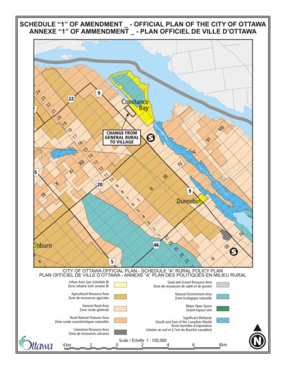
The amendment also introduces an
expansion of the Village boundary as shown on Schedule A of the Official Plan
in order to provide a better road connection from Allbirch Street to the
Kilmaurs Side Road. This road, to be
built through the subdivision process, would provide a second access into the
Village in case of an emergency.
Currently, Constance Bay Road provides the only access in and out of the
village. The road alignment shown in
the former West Carleton Official Plan is not feasible due to physical
constraints (gulleys) and potential conflicts with a residence on Kilmaurs Side
Road. The expansion of the village
boundary to the west provides sufficient space to avoid the physical
constraints and enables the road to be located so it will have less impact on
the nearby residence.
Section 2.2.2 on Village
Boundaries in the 2003 Official Plan expresses Council’s policy on village
boundary amendments. The proposed
amendment is consistent with this policy.
Where the policy requires that development of new village lands be
guided by a community design plan, the new village land in Constance Bay will
be guided by the Community Plan.
Further, Section 2.2.2 requires that the proposal meet the requirements
of rural servicing, a requirement met by the proposed Environmental Management
Plan and requirements for hydrological studies to support new development. Section 2.2.2 also requires consideration of
the effects of the proposed boundary on the village structure and character;
the proposed boundary change improves the structure of the village by providing
a second access road to the community.
No negative impact on the Village character has been identified through
the consultation. Finally, no
agriculture areas, mineral resource areas, or environmental areas are affected
by the proposal.
The proposed amendment is also
consistent with the 2005 Provincial Policy Statement (PPS). The 2005 PPS permits the expansion of a
settlement area, such as a village, on the basis of a comprehensive review,
which can be in the form of an official plan amendment initiated by the
municipality. Among other matters, the
PPS requires that expansions be considered with respect to opportunities for
growth within the designated area and the availability of infrastructure. In this case, the proposed addition of 20 ha
to the village replaces some of the land with residential potential that was
designated in the former West Carleton Official Plan. This plan designated as residential about 30 ha identified by the
Ministry of Natural Resources as a provincially significant ANSI. In 2004 the city purchased this property to
ensure it would be protected as a Natural Environment Area.
SUMMARY OF ISSUES
The draft Community Plan was made
available for everyone in the community to review. Two community meetings were held to discuss the recommendations
in the draft Plan. The issues raised
during the consultation process are summarized below.
Beach Protocol
There were a number of comments
received from the public regarding the need to address problems related to
maintenance and access to the beach area.
There was support for development of a community-based protocol provided
that it is based on an open and transparent process.
The Plan has been revised to better define the role of the Beach
Steering Committee and ensure that everyone in the community has an opportunity
to participate in the development of the beach protocol.
Community Park Boundary
The Community Park is located on
the south side of Len Purcell Drive and is bounded on three sides by the ANSI. The CBBCA has raised concerns about boundary
of the Community Park as shown in the draft Plan. The CBBCA feels that additional land is required for the
community park to provide for the future recreation needs of the
community. The Natural Environment Area
designation/ANSI of the area would limit the ability for the community park to
be expanded in the future. The CBBCA
has requested that the Community Plan be revised to provide for a process to
review the lands by incorporating a clause to list the property of interest
around the CBBCA community centre as "Future Community Park" with the
necessary wording to indicate that the community of Constance Bay has requested
re-designation of said lands to Community Park.
The Plan has been revised to provide a process for the review of the
Community Park/Natural Environment Area boundary. The Plan now states that the precise boundary of the Community
Park will be defined in the zoning by-law based on a review of the Natural
Environment Area/ANSI boundary. The
City will undertake an evaluation of the site in consultation with the MNR to
determine the precise boundary of the ANSI and the Community Park, which will
be shown in the new zoning by-law.
The CBBCA has also raised
concerns regarding the use of these lands.
While there are several issues the most pressing is the poison ivy that
dominates the ANSI and encroaches on the sports fields. The community expects the CBBCA to lead the
resolution of these problems. The CBBCA
feels that a designation of Torbolton Forest moves these lands under the
stewardship of the city's Forestry boards and departments which they believe is
a potentially insurmountable and completely unnecessary obstacle.
The Torbolton Forest is managed by the City' Public Works and Services
Department (Parks and Forestry Division).
Poison ivy is a health and safety issue and the Department has indicated
that if poison ivy is a problem in public areas, the City will take immediate
action to remove it. Management of the
lands adjacent to the community centre will be undertaken in consultation with
the CBBCA.
Village Boundary Change
The owners of the lands within
the New Residential Development Area have indicated that the road alignment for
the connection between Allbirch Street and Kilmaurs Side Road as shown in the
draft Community Plan is not feasible due to physical constraints (gulleys) and
potential conflicts with a residence on Kilmaurs Side Road.
The road alignment for the road connection originated in the former
West Carleton Plan and was carried forward into the draft Community Plan. A site visit with land owners has confirmed
that the alignment that was proposed in the draft Plan is not practical. An expansion of the Village boundary as
shown on Schedule A of the Official Plan is being proposed in order to provide
a better road connection from Allbirch Street to the Kilmaurs Side Road. The expansion of the village boundary to the
west provides sufficient space to avoid the physical constraints and enables
the road to be located so it will have less impact on the nearby residence.
ENVIRONMENTAL IMPLICATIONS
The
Community Plan requires that an Environmental Management Plan be undertaken for
the new development area to guide future development. Approximately 20 ha is proposed to be redesignated to
"Village" from "General Rural Area". The EMP will address stormwater management,
protection of significant natural features, and protection of the groundwater supply. The Plan also encourages property owners to
implement best management practices to reduce the impact of development along
the Ottawa River shore.
RURAL IMPLICATIONS
The
Community Plan is a comprehensive document that sets out the community's
priorities for the future and the strategies for implementation. The Community Plan has two components, a Land Use Plan to address growth
management, land use and development issues and a Community Development Strategy to address community needs regarding
facilities and programs that are required both now and in the future.
CONSULTATION
A
collaborative community process was used to develop the Community Design
Plan. Two workshops were held in the
community to develop the vision and the strategies to achieve that vision. The results of the workshop were verified in
a survey distributed to all residents of Constance Bay. Approximately 2,100 surveys were distributed
and 367 were returned, a return rate of 17.5%.
The
draft plan is based on the results of the visioning and strategic directions
workshops. Two community meetings were
held to discuss the draft Community Plan.
The Community Plan has been revised based on the comments received on the
draft Plan.
The
draft Community Plan was circulated to the Torbolton Forest Advisory Committee
and Council's Ottawa Forests and Greenspace Advisory Committee and the
Environmental Advisory Committee, and their comments were incorporated into the
revised Plan.
Notice
of the Agriculture and Rural Affairs Committee and the Planning and Environment
Committee meeting to consider the Plan was published in the West Carleton
Review.
Councillor
El-Chantiry is aware of the Community Plan process.
FINANCIAL IMPLICATIONS
The
Community Plan is a long-range document that articulates community needs and
priorities in the future. The cost of
these initiatives will be determined by the respective Departments during the
annual budget preparation process.
SUPPORTING DOCUMENTATION
Document
1 - Official Plan Amendment __
Document
2 - Community Plan for the Village of Constance Bay issued separately and filed
with the City Clerk
Document
3 - Consultation Details.
DISPOSITION
1. The
Planning and Growth Management Department will issue the Notice of Decision
within the 20 day appeal period for Amendment __.
2.
The Planning and Growth Management Department will revise
Annex 5 to the Official Plan to indicate that the Village of Constance Bay is
subject to a Community Design Plan (replacing the reference to a Village Plan).
OFFICIAL PLAN AMENDMENT DOCUMENT
1
AMENDMENT
NO. __ TO THE OFFICIAL PLAN (2003)
OF THE CITY OF OTTAWA
COMPONENTS
PART
A – THE PREAMBLE
Purpose...............................................................................................................................................
Location..............................................................................................................................................
Basis...................................................................................................................................................
PART B – THE AMENDMENT
Introduction.........................................................................................................................................
Details.................................................................................................................................................
Implementation....................................................................................................................................
COMPONENTS
PART A – THE PREAMBLE does
not constitute part of this Amendment.
PART B – THE AMENDMENT,
consisting of the following text and Schedule 1, constitutes Amendment No. __
to the Official Plan of the City of Ottawa.
PART A - THE PREAMBLE
1. Purpose
The purpose of Amendment __ is to
delete the reference to Constance Bay in the village plan for "Constance
Bay, Dunrobin, Fitzroy Harbour, Galetta, Kinburn" in Volume 2C as the
secondary plan for Constance Bay will be superseded by the Community Plan for
the Village of Constance Bay.
2. Location
This amendment applies to the
area designated as “Village” in the Ottawa Official Plan.
3. Basis
The Community Plan for the
Village of Constance Bay replaces the Official Plan policies for Constance Bay
that were adopted by the former Township of West Carleton in 1992. It updates the old plan and provides
guidance for how the policies in the new Ottawa Official Plan will be
implemented. The plan was developed
collaboratively with the community and it provides direction for how the
village will develop in the future.
Section
2.5.6 8 of the Official Plan states that Council will approve community design
plans as policy documents to guide future development. Policy 4, states that secondary plans existing
prior to the formation of the new City of Ottawa are included in Volume 2 and
that over time community design plans will replace many of these secondary
plans. The secondary plan for the
village of Constance Bay is found in Volume 2C. This amendment deletes the reference to Constance Bay in the
village plan for "Constance Bay, Dunrobin, Fitzroy Harbour, Galetta,
Kinburn" in Volume 2C as the secondary plan for Constance Bay will be
superceded by the community plan. The
Community Plan for the Village of Constance Bay will be approved by City
Council, as a policy document, to guide the long-term growth and development of
Constance Bay, based on the vision residents of the village hold. It will provide guidelines for the
day-to-day decision-making on land use planning, such as subdivision, zoning
and site plan applications, and it sets out the community’s priorities for the
future.
The amendment also introduces an
expansion of the Village boundary on Schedule A of the Official Plan in order
to provide a better road connection from Allbirch Street to the Kilmaurs Side
Road. This road, to be built through
the subdivision process, would provide a second access into the Village in case
of an emergency. Currently, Constance
Bay Road provides the only access in and out of the village. The road alignment shown in the former West
Carleton Official Plan is not feasible due to physical constraints (gulleys)
and potential conflicts with a residence on Kilmaurs Side Road. The expansion of the village boundary to the
west provides sufficient space to avoid the physical constraints and enables
the road to be located so it will have less impact on the nearby
residence. The 20 ha expansion provides
additional land for residential development in Constance Bay, replacing some of
the residential potential that was designated in the former West Carleton
Official Plan. The West Carleton Plan
had designated, as "Residential", approximately 30 ha of land that
had been classified by MNR as a provincially significant Area of Natural and
Scientific Interest (ANSI). In 2004 the
City purchased this property to protect it as a Natural Environment Area.
PART
B - THE AMENDMENT
1. Introduction
All of this part of this document
entitled Part B - The Amendment, consisting of the following text and Schedule
1, constitutes Amendment No. __ to the Official Plan of the City of Ottawa.
2. Details
2.1 Ottawa Official Plan Volume 2C “Village
Plans for Constance Bay, Dunrobin, Fitzroy Harbour, Galetta, Kinburn ” is
hereby amended by:
a) Deleting
the reference to Constance Bay in the title so that it reads “Dunrobin, Fitzroy
Harbour, Galetta. Kinburn”;
b) Section
6(8)(a) is amended by deleting the words “Constance Bay Schedule “C”
c) Sections
6(8)(b), (c), (d) (e), (f) are amended by deleting the phrase “Village
Schedules “C” to “G” and replacing it with “Village Schedules “D” to “G”;
d) Schedule
“C” (the land use plan) for Constance Bay is deleted;
e) Section
6(8)(h) “The Village of Constance Bay – Schedule C” is deleted in its entirety.
2.2 Schedule A is hereby amended as follows:
a) The
area designated “General Rural Area” is changed to “Village” as shown on
Schedule 1.
3. Implementation
The implementation of this
Amendment to the Official Plan shall be in accordance with the policies of the
2003 Official Plan of the City of Ottawa.
DOCUMENT 3
CONSULTATION DETAILS
There was extensive community
consultation in developing the Community Plan for Constance Bay. The draft Community Plan was discussed at
two community meetings (October and February).
The following is a summary of the written comments that were received on
the draft Community Plan.
Constance
and Buckham’s Bay Community Association (CBBCA)
The CBBCA has raised concerns
about the boundary of the Community Park as shown in the draft Plan. The CBBCA feels that additional land is
required for the community park to provide for the future recreation needs of
the community. The Natural Environment
Area designation/ANSI limits the ability of the community park to be expanded
in the future. The CBBCA has requested
that the Community Plan be revised to provide for a process to review the lands
by incorporating a clause to list the property of interest around the CBBCA
community center as "Future Community Park" with the necessary
wording to indicate that the community of Constance Bay has requested
re-designation of said lands to Community Park.
Response
The
City owns all of the land surrounding the community centre and park and this
land has been identified as an ANSI by the province. The Constance Bay Sand Hills ANSI
is designated as Natural Environment Area in the Ottawa Official Plan. The Plan has been revised
to provide a process for the review of the Community Park/Natural Environment
Area boundary. The Plan now states that
the precise boundary of the Community Park will be defined in the zoning by-law
based on a review of the Natural Environment Area/ANSI boundary. The City will undertake an evaluation of the
site in consultation with the MNR to determine the precise boundary of the ANSI
and the Community Park, which will be shown in the new zoning by-law.
The CBBCA has also raised
concerns regarding the use of these lands.
While there are several issues the most pressing is the poison ivy that
dominates the ANSI and encroaches on three of our sports fields. The community expects the CBBCA to lead the
resolution of these problems. A
designation of Torbolton Forest moves these lands under the stewardship of the
city's Forestry boards and departments.
The CBBCA believes this a potentially insurmountable and completely
unnecessary obstacle.
Response
The Torbolton Forest is managed by the City' Public
Works and Services Division (Parks and Forestry Division). Poison ivy is a health and safety issue and
the Department has indicated that if poison ivy is a problem in public areas
the City will take immediate action to remove it. Management of the lands adjacent to the community centre will be
undertaken in consultation with the CBBCA.
Torbolton
Forest Advisory Committee
The Torbolton Forest Advisory
Committee applauds the recognition in the Plan of the importance to preserve
the Torbolton Forest and provided the following comments:
- Schedule A should be revised to show, both the
public lands, the Torbolton Forest, and the Natural Environment Area which
encompasses a larger area – the current references are confusing;
- The Rare Plant Inventory which was done in
2003-2004 should provide the basis for updating the Forest Management
Plan;
- The Forest Management Plan should include provision
of forest fire hazard information to the public;
- The Forest Management Plan should include plans for
developing/maintaining trails in such a way that conflicting uses are
minimized
Response
The Community Plan has been
revised to address the comments:
- Schedule A has been revised to show the
Torbolton Forest, and the Natural Environment Area, which encompasses a
larger area.
- Section 6.1 of the Plan has been revised to
incorporate all of the comments provided by the Torbolton Forest Advisory
Committee related to the Forest Management Plan for the Torbolton Forest
Ottawa Forests and Greenspace Advisory
Committee
OFGAC
recommends that the draft plan be modified to:
·
Address
not only the retention of trees in new development but also the retention of
trees during redevelopment through the requirement of a tree protection plan to
be included in the building permit requirements for additions and replacement
buildings.
·
Recommend that development and redevelopment not be approved if the site
plan indicates that the retention of most existing mature trees is not
possible.
·
The tree preservation plan require retention of natural plantings along
and near the shorelines, to help reduce erosion in floodway areas, to retain
the natural atmosphere of the beach areas, and to provide shade in and near
beach areas. This can be addressed
through restricting building footprints along waterfront properties and
enforcing regulated setbacks on not only roadsides, but watersides.
Response
New
residential subdivisions will be required to provide a tree preservation and
planting plan. The older parts of the
village, particularly along the water, have been developed with single-family
dwellings and there is little opportunity for redevelopment by plan of
subdivision or site plan. Building
permits are tied to the building code and cannot require tree protection. Tree cutting by-laws provide the tools to
control the cutting of trees; however, this issue is of concern of all
communities and should be addressed in a comprehensive manner, not specifically
in Constance Bay.
OFGAC recommends that Section 2.3.2 be
modified to:
- Include provisions in the determination of the size of lots on new
development lands that address not only the requirements for sustainable
private servicing (i.e. water and septic) to be determined by the
Groundwater Study, but also for the retention of individual and groups of
trees on each of the lots where these features naturally occur, or for
planting of new native tree species where they do not presently occur.
- Considered a minimum 0.8 ha when looking at design options for new
development. It should be recognized that in keeping with the wishes of
the community to retain the natural features of the community, it may be
necessary to increase the lot size to accommodate natural features.
- Require a detail natural systems report be developed which would be
the basis for determination of subdivision design.
Response
There are a number of factors that will
influence the lot size in the New Residential Development Area.
·
The Environmental Management Plan
(EMP) will identify important natural features on the site. The EMP will provide guidance on measures to
protect significant features on the site.
·
The groundwater study indicated that hydrological studies to support new
development within the Village will take into account the observed build-up of
nitrates in the overburden sand aquifer and will provide measures to minimize
additional nitrate loading
These factors will determine the
appropriate lots sizes when the detailed review is done at the subdivision
stage.
OFGAC
recommends extending the planting of street trees to the full length of
Constance Bay Road.
Response
Tree planting will be required for new
development, within the village boundary through the development process (at
the developer’s expense). There are no
tools available to require tree planting along Constance Bay Road outside the
village.
OFGAC
recommends that Schedule A be corrected to show both the Natural Environment
Area and the Torbolton Forest.
Response
Schedule A has been
revised to show the part of the Natural Environment Area that is owned by the
City. The land owned by the City is
known as the Torbolton Forest. The
Torbolton Forest is now shown on Schedule A for information.
OFGAC recommends
that protection of rare plants be considered in public areas where poison ivy
control is being considered.
Response
The Forest Management Plan will
implement the recommendations of the Rare Plant Inventory and Management
Recommendations for the Torbolton Forest report in order to protect and enhance
the special ANSI features.
OFGAC recommends that the draft plan include
recommendations to support, through budget and other resources, the continued
study and development of a long term sustainable management plan which includes
implementation of the recommendations found in the Rare Plant Inventory Report
and monitoring the results of management activities.
OFGAC recommends the Plan be modified to
recognize the specialized priorities which have been previously identified for
the management of the Forest in the Rare Plant Inventory. The updating of the operating and capital
plans should include consideration of protecting and enhancing the special Area
of Natural and Scientific Interest (ANSI) features as well as addressing the
continuing efforts to improve the Forest’s health and increase diversity of
tree species. Cultural use should be
considered within the context of sustainability of the natural features.
Response
A policy has been added to state that the Forest Management Plan will
implement the recommendations of the Rare Plant Inventory and Management
Recommendations for the Torbolton Forest report in order to protect and enhance
the special ANSI features and address the continuing efforts to improve the
Forest’s health and increase diversity of tree species.
OFGAC recommends that the draft plan include
the recommendation that rare plant communities on the beach be located and
protected, and that major migratory stopping sites along the shoreline continue
to be accessible to the public for passive activities such as bird watching.
Response
The
beach area is not in City ownership.
The Plan contains policies that the road allowances that provide access
to the river be maintained to provide access to the water.
Mississippi Valley Conservation (MVC)
MVC
commented that their staff has been involved in reviewing and providing input
on the draft document and their comments and recommendations have consistently
been addressed throughout the process.
One item, however, requires clarification regarding the flood
plain. The two-zone concept for flood
plain management as described in Section 3.6 applies only to already developed
residential lands along the Ottawa River and Buckham’s Bay and provides for
development on lots of record only. The
Plan should be revised to indicate that in the New Residential Development
Area, the entire flood plain should be treated as one zone where new
development is prohibited within the entire flood plain.
Response
Schedule A has been revised to indicate that the
flood plain within the area designated “New Residential Development Area” is
within the Floodway. No new development is permitted within the
Floodway.
MVC
also commented that they would like to see stronger wording in the Community
Plan to flag the very likely need for lots larger than the 0.4 ha currently
required by the former West Carleton Official Plan to address the concerns
raised in the groundwater study regarding nitrates.
Response
The Plan states that the minimum lot
size for new development will be determined in accordance with the
recommendations of the Groundwater Study.
The site specific assessments will be required to follow Ministry of the
Environment (MOE) Guideline D-5-4 "Individual On-site Sewage
Systems: Water Quality Risk Assessment" and MOE Guideline D-5-5
"Technical Guideline for Private Wells: Water Supply
Assessment". Larger lot sizes will
be required where results of a hydrogeology and terrain analysis to support the
development indicate that larger lot sizes are required.
Owners of the
New Residential Development Area Lands
The owners of the lands within the New Residential Development Area
have indicated that the road alignment for the connection between Allbirch
Street and Kilmaurs Side Road as shown in the draft Community Plan is not
feasible due to physical constraints (gulleys) and potential conflicts with a
residence on Kilmaurs Side Road.
Response
A site visit with landowners has confirmed that the alignment that was
proposed in the draft is not practical.
The expansion of the Village boundary as shown on Schedule A of the
Official Plan is being proposed in order to provide a better road connection
from Allbirch Street to the Kilmaurs Side Road. The expansion of the village boundary to the west provides
sufficient space to avoid the physical constraints and enables the road to be
located so it will have less impact on the nearby residence.
Comments from
Individuals
Eight individuals provided
comments on the draft Community Plan.
Some of the responses received provided detailed comments suggesting
revised working to clarify the policies in the plan. These comments were incorporated into the Plan. The following comments were received
regarding specific policies:
Management of the beach
·
The most important issue in the
Plan is the beach, support the strategy to develop a guideline on use of the
beach by all – there is still the outstanding legal question of the actual
ownership of the beach, which should be settled as soon as possible.
·
The plan does not address
problems on the beach – dogs being off leash, ATVs and motorcycles on the
beach, occasional drinking parties – any significant change in use of the beach
will result in legal challenges – hence the process should be extremely open
Response
The Plan has been revised to
better define the role of the Beach Steering Committee and ensure that everyone
in the community has an opportunity to participate in the development of the
beach protocol. The role of the
committee will be to oversee a process to provide an opportunity for everyone
in the community to participate and provide input. City staff will participate and act as a resource to explain the
tools (from by-law, police, planning, fire, parks and recreation services) that
are available to address the problems that have been identified.
Management of the Road Allowances
to the Water
·
There is the ongoing operation
and maintenance costs associated with upgrading the major beaches in the area
(toilets, garbage, parking etc.) – the City must guarantee proper maintenance
of these facilities;
·
Consider selling off some of the
unopened road allowances if they are not needed from a beach access point of
view - the revenue gained could finance
other initiatives.
Response
·
Any
new facilities that the City provides at the road allowances will include a
provision for their maintenance;
·
During
the consultation process, the community provided clear direction (71% of
respondents who participated in the survey) that all of the road allowance to
the water should remain in public ownership.
The road allowances are seen as a heritage resource by the community
that should not be sold. The policies
in the Community Plan state that all of the road allowances should continue to
remain in public ownership.
Lighting
·
The community vote, which did not
favour improved lighting in the community, should be revisited
Response
- During the consultation process there was no
clear consensus from the community that improved lighting was a priority
in the community.
VILLAGE
OF CONSTANCE BAY – COMMUNITY PLAN
VILLAGE DE CONSTANCE BAY – PLAN
COMMUNAUTAIRE
Having
heard the staff presentation on this item at its previous meeting, the
Committee went directly to the public delegations.
Mr.
D. Lazier, a resident, stated that pursuant to his presentation to
Committee on April 27, staff had proposed changes to Section 9 of the Community
Plan and, having seen these proposed amendments, he was satisfied that his
concerns had been addressed.
Ms.
K. Black, a resident, addressed the issue of redrawing the boundary for the
Village of Constance Bay. She expressed
concerns with respect to ground water and the fact that the environmental
management study had not been completed.
She wondered about the impact to areas that would become part of the
village boundary and whether these impacts had been adequately studied. Mr. Mahon distinguished, on the map of the
Village plan, the area identified for new residential development versus the
area of the village boundary expansion.
With respect to village boundary expansion, stated that it was necessary
in order to allow for the secondary access road into Constance Bay. He indicated that the preliminary results of
the environmental management plan had been presented at a community meeting in
February. He explained that constraints
mapping had been done and that no constraints had been identified. With respect to the area identified for new
residential development, he maintained that the environmental management plan
would provide guidance with respect to any future plans of subdivision insofar
as stormwater management and identifying areas and/or features to be
protected.
Responding
to questions from Councillor Brooks, Mr. Mahon confirmed that the recommendation
was to expand the village boundary. He
explained that this proposal met the requirements of the City’s Official Plan
and of the Provincial Policy Statement.
The area into which the village is being expanded is currently zoned as
general rural therefore there are no implications in terms of loss of
resources. Furthermore, the proposed village expansion will help replace some
of the residential growth potential that was lost in 2004 because of the ANSI
designation.
Councillor
Brooks stated that he was not opposed to expansion. He referenced a community design plan for North Gower, which was
in its final stages because he believed one of the problem with that CDP would
be the expansion of the boundary. He
noted that the Official Plan required that, in order to expand the village
boundary, there had to be a demonstrated need for additional housing. Mr. Mahon explained that in the case of the
Constance Bay CDP and village boundary expansion, there were two issues: the need to provide for a second access road
and the fact that some residential potential had been lost as a result of the
ANSI designation.
Responding
to questions from Councillor El-Chantiry, Mr. Mahon indicated there would not
be a requirement to conduct a full Environmental Assessment (EA) prior to
developing the area. He explained that
the environmental management plan would set the broad framework for the
preparation of the plan of subdivision and that the road would be created
through the subdivision process.
However, he noted that the plan of subdivision would require approval
through a public process, therefore residents and members of Council would get
to review the plan and have input into it.
He also confirmed that the process would include requirements with
respect to such details as lot sizes, water testing and a hydrogeology
study.
Councillor
El-Chantiry stressed the need to move forward with the CDP and he assured Ms.
Black that any new development in the area would have come back to Committee
and would have to follow a public process.
Ms.
Black wondered if a plan of subdivision would be going in imminently and
whether residents in the immediate vicinity of the boundary expansion had been
notified. Mr. Mahon indicated he was
aware of some interest in developing the area.
However, he advised that no applications had been submitted. He believed potential developers were
waiting for the results of the environmental management plan before proceeding
with any applications. He assured
Committee that any plan of subdivision would be advertised and that a notice
would be posted on the site to advise residents of the proposal.
Mr.
C. Thomson referenced his presentation before Committee at its last
meeting, where he spoke on behalf of his father and sister and he re-iterated
his requested that Committee direct staff to recognize the mobility limitations
of seniors and persons with disabilities, so as to respond appropriately in
developing a parking strategy discussed in Section 8.1 of the Village Plan. He noted that his father had submitted this
same requested in writing, in an e-mail to Councillor El-Chantiry dated May 10,
2006. Mr. Thomson read his father’s
e-mail (held on file) into the record.
Councillor El-Chantiry indicated he would be pleased to move that direction
to staff.
Mr.
D. Maloney, a resident, indicated he lived on Kilmaurs Side Road and that
he had only been made aware of the proposed village boundary expansion a few
days prior to the meeting. He expressed
concerns with respect to increase traffic on his road and he asked whether any
traffic studies had been conducted. He
also expressed concerns with respect to the lack of requirement for a full EA
and he questioned the need for additional housing, as required by the Official
Plan. Mr. Maloney then engaged
Councillor Brooks in a discussion with respect to the North Gower CDP and
village boundary expansion. He inquired
as to the studies been relative to that project; whether EA studies and traffic
impact studies had been done in advance of expanding the village boundary. Councillor Brooks indicated that a number of
studies had been completed but that there had not been an up-to-date EA
done. He explained that an EA was
conducted 6 years ago, the last time the village boundary was expanded. However, he noted that the environment
around North Gower was different from the environment around Constance Bay;
that North Gower was high and dry.
With
respect to the need for a full EA, Mr. Mahon explained that the consultants
doing the environmental management plan had done some constraint mapping in
order to determine if there were any constraints in the area for future
development. He indicated the area
contained old pasture fields and that it was high and dry. The only wetland in the vicinity was fairly
far away. In terms of the potential for
residential development within the existing village, he advised that the
opportunities were limited because of the lot size requirements. He noted that the former West Carleton plan
required 1 acre lots because of servicing concerns. Mr. Mahon noted that traffic concerns had also been raised at the
previous meeting and that, in order to address them, staff were proposing an
amendment to Section 4.1 of the CDP, which would require that a traffic impact
study be done to support the subdivision applications for the new residential
development area.
Mr.
R. Wall, a resident, indicated he was one of the land owners affected by
the proposed boundary expansion. He
referenced the history with respect to the efforts, over many years, to build a
second access road into Constance Bay.
He stressed the importance of building a second access road because,
should there ever be a fire in Constance Bay, residents would to be able to get
out. He believed the boundary expansion
was necessary in order to allow for the new road. Furthermore, he believed Constance Bay would grow and that it was
just a matter of time before the land was developed. Mr. Wall talked about the importance of residents getting
involved in their community and with their community association. He noted that the CDP process had been well
advertised and that he had gotten involved last summer by participating in the
various meetings. He expressed support
for the village boundary expansion, noting that any housing development would
have to go through the proper processes; conducting various studies and
engaging the public in consultation.
Mr. Wall also submitted a comment sheet, which is held on file with the
City Clerk.
Mr.
L. Jaros, a resident, indicated he had learned of the project a few months
prior. He advised that since becoming
aware of the project, he had found staff to be very helpful and
cooperative. However he submitted that
residents in the expansion area had not been involved in the CDP process. Mr. Jaros maintained that he had
specifically chosen to live outside the Village of Constance Bay because he
wanted a quiet lifestyle. He referenced
a questionnaire sent out to 2,000 residents in Constance Bay. He noted that approximately 400 people
responded to the questionnaire and that, of those who replied, 199 expressed
support for a secondary access road.
Based on this data, he argued that his lifestyle would be impacted
because of less than 10% of the residents of Constance Bay.
Dr.
B. Firestone, an urban designer, suggested there were 2 ways of approaching
planning matters; they could be confrontational or they could be
affirming. He felt Community Design
Plans were affirming processes because they allowed residents to get involved
in shaping their communities. He
submitted that CDPs lead to better development; better use of existing
investment, higher property values, and fewer Ontario Municipal Board (OMB)
hearings. In closing, Dr. Firestone
expressed support for the Constance Bay CDP.
Councillor
El-Chantiry offered some closing comments on this issue. He thanked those who had participated and
provided input, he noted that staff had addressed concerns raised by residents,
and he maintained that the majority of residents were pleased with what was
being proposed.
Moved
by Councillor E. El-Chantiry
That staff
be directed to recognize the mobility limitations of seniors and persons with
disabilities so as to respond appropriately in developing a parking strategy,
discussed in Section 8.1 of the Village Plan.
CARRIED
Moved
by Councillor E. El-Chantiry
WHEREAS the Community Plan policies for the
area designated New Residential Development Area requires a new road to be
constructed to provide a road connection between Allbirch Street and Kilmaurs
Side Road;
AND WHEREAS increased traffic from the new road
to Kilmaurs Side Road will exit on Dunrobin Road;
THEREFORE BE IT RESOLVED that Section 4.1 of
the Community Plan be amended to assess the impact of the new road on the
Kilmaurs Side Road – Dunrobin Road Intersection by adding the following as new
policy 3:
“The requirements for the new road
connecting to Kilmaurs Side Road described in policy 2 above the intersection
at Dunrobin Road will be investigated through a traffic impact study that will
be required to support the subdivision applications for the New Residential
Development Area.”
CARRIED
Moved
by Councillor E. El-Chantiry
WHEREAS the strategies
in Section 9 of the Community Plan call for the creation of a Community Committee
to oversee a process to create a beach protocol for Constance Bay;
AND
WHEREAS the City will help to coordinate and establish a community committee
(Beach Steering Committee), to work with the community and
waterfront owners to establish a protocol for the use and maintenance of the
beach;
AND
WHEREAS it must be clear that the members of the Beach Steering Committee will
not include representatives of the City or Government agencies;
AND WHEREAS any
community meetings should be scheduled in July and August to ensure that
everyone in the community (both seasonal and permanent residents) has the
opportunity to participate;
THEREFORE
BE IT RESOLVED that the strategies in Section 9 be deleted and replaced with
the following:
The City will help to co-ordinate and establish
a community committee, (Beach Steering Committee) to work with the community
(that includes both waterfront owners and non waterfront owners) to establish a
protocol for the use and maintenance of the beach. The role of the committee will be to oversee a process to help
the community to develop a beach protocol for Constance Bay. The protocol will address existing
management problems as well as use and maintenance of the beach area. The process to develop the protocol should
provide an opportunity for everyone in the community to participate and provide
input. Staff from the City, the
Mississippi Valley Conservation Authority (MVCA) and the Ministry of Natural
Resources (MNR) will support the process by providing information as to the
tools that are available to address problems identified by the community. The participants required to help the
community develop the protocol include:
·
The
Community – waterfront owners and community members who do not own waterfront
property
·
The
City – representatives from By-law, Recreation, Fire, Police, Planning and
Growth Management
·
Government
agencies – Ministry of Natural Resources, Mississippi Valley Conservation
Authority
The
proposed protocol will be presented and discussed at a community meeting that
is advertised in the community. The
community meeting must take place during the months of July or August.
CARRIED
The
Committee then voted on the amended recommendations.
That the Agriculture and Rural Affairs
Committee recommend Council:
1. Adopt Official Plan Amendment xx, as
attached in Document 1, to repeal the Village Plan for Constance Bay that is in
Volume 2C of the Official Plan and make a change to the village boundary on
Schedule A of the Official Plan.
2. Approve the Community Plan for the
Village of Constance Bay as attached in Document 2 (issued separately) and
as amended by the following:
a) WHEREAS
the Community Plan policies for the area designated New Residential Development
Area requires a new road to be constructed to provide a road connection between
Allbirch Street and Kilmaurs Side Road;
AND WHEREAS increased traffic from
the new road to Kilmaurs Side Road will exit on Dunrobin Road;
THEREFORE BE IT RESOLVED that
Section 4.1 of the Community Plan be amended to assess the impact of the new
road on the Kilmaurs Side Road – Dunrobin Road Intersection by adding the
following as new policy 3:
“The requirements for the new road
connecting to Kilmaurs Side Road described in policy 2 above the intersection
at Dunrobin Road will be investigated through a traffic impact study that will
be required to support the subdivision applications for the New Residential
Development Area.” ; and
b) WHEREAS the strategies in Section
9 of the Community Plan call for the creation of a Community Committee to
oversee a process to create a beach protocol for Constance Bay;
AND
WHEREAS the City will help to coordinate and establish a community committee
(Beach Steering Committee), to work with the community and
waterfront owners to establish a protocol for the use and maintenance of the
beach;
AND
WHEREAS it must be clear that the members of the Beach Steering Committee will
not include representatives of the City or Government agencies;
AND
WHEREAS any community meetings should be scheduled in July and August to ensure
that everyone in the community (both seasonal and permanent residents) has the
opportunity to participate;
THEREFORE BE IT RESOLVED that the strategies in Section 9 be
deleted and replaced with the following:
The City will help to co-ordinate and establish a
community committee, (Beach Steering Committee) to work with the community
(that includes both waterfront owners and non waterfront owners) to establish a
protocol for the use and maintenance of the beach. The role of the committee will be to oversee a process to help
the community to develop a beach protocol for Constance Bay. The protocol will address existing
management problems as well as use and maintenance of the beach area. The process to develop the protocol should
provide an opportunity for everyone in the community to participate and provide
input. Staff from the City, the
Mississippi Valley Conservation Authority (MVCA) and the Ministry of Natural
Resources (MNR) will support the process by providing information as to the
tools that are available to address problems identified by the community. The participants required to help the
community develop the protocol include:
·
The Community – waterfront owners and community
members who do not own waterfront property
·
The City – representatives from By-law, Recreation,
Fire, Police, Planning and Growth Management
·
Government agencies – Ministry of Natural Resources,
Mississippi Valley Conservation Authority
The proposed protocol will be presented and
discussed at a community meeting that is advertised in the community. The community meeting must take place during
the months of July or August.
CARRIED
as amended