1. KANATA
WEST DEVELOPMENT AREA CLASS ENVIRONMENTAL ASSESSMENTS - TRANSPORTATION,
SERVICING AND RIVER RESTORATION ÉVALUATIONS
ENVIRONNEMENTALES DE PORTÉE GÉNÉRALE DE LA ZONE D'AMÉNAGEMENT DE KANATA-OUEST
– TRANSPORTS, VIABILISATION ET REMISE EN ÉTAT DE LA RIVIÈRE |
JOINT
commITTEES RECOMMENDATIONS as amended
That Council approve:
1. The recommended projects identified in
the Kanata West Master Servicing Plan and Carp River, Poole Creek and Feedmill
Creek Restoration Class Environmental Assessments, as shown in the attached
drawings 6-15, in accordance with the requirements of the Ontario Environmental
Assessment Act and Council’s resolutions of March 26, 2003; and
2. That Staff finalize the Kanata West
Master Servicing Plan and the Carp River, Poole Creek and Feedmill Creek
Restoration Class Environmental Assessment Reports and proceed with the 30-day
public review, in accordance with the Ontario Environmental Assessment Act and
as a prelude to the initiation of the detailed design.
3. The recommended projects identified in
the Kanata West Transportation Master Plan as shown in the attached drawings
1-5, in accordance with the requirements of the Ontario Environmental
Assessment Act and Council’s resolutions of March 26, 2003; and
4.
That Staff finalize
the Master Plan Class Environment Assessment Report and Environmental Screening
Report and proceed with the 30-day public review, in accordance with the
Ontario Environmental Assessment Act and as a prelude to the initiation of the
detailed design.
5. That
the City make it a requirement that a warning be placed on title of property
lying within the flood fringe lands of the Carp River, including lands that
have been raised above the 1:100 year flood elevation.
6. That
the City inform the Sensplex of the Carp River, Poole Creek and Feedmill Creek
Restoration Class Environmental Assessment.
recommandations modifiÉes dES COMITÉS CONJOINTS
5. Que la Ville exige l’ajout d’un
avertissement au titre des propriétés situées dans la plaine inondable de la
rivière Carp, y compris les terrains qui ont été élevés au-dessus du niveau de
crue centenaire.
6. Que la Ville informe les
responsables du Sensplex de l’évaluation environnementale de portée générale
visant le rétablissement de la rivière Carp et des ruisseaux Poole et Feedmill.
Documentation
1.
Deputy City Manager, Planning and Growth Management report dated 5 April 2006
(ACS2006-PGM-POL-0032)
2.
Extract
of draft Minutes, 3 May 2006.
Report
to/Rapport au :
Joint Transportation
Committee and Planning and Environment Committee
Réunion conjointe du Comité des transports et du Comité de l’urbanisme
et de l’environnment
5 April 2006 / le 5 avril 2006
Submitted by/Soumis par : Ned Lathrop, Deputy City Manager/Directeur municipal
adjoint
Planning and Growth Management / Urbanisme
et Gestion de la crosissance
Contact Person/Personne
ressource : Dennis Jacobs, Director/Directeur
Planning, Environment and Infrastructure
Policy/Politique d'urbanisme, d'environnement et d'infrastructure
(613) 580-2424 x 25521, Dennis.Jacobs@ottawa.ca
REPORT RECOMMENDATION
That
Planning and Environment Committee and Transportation Committee recommend City
Council approve:
1. The
recommended projects identified in the Kanata West Master Servicing Plan and
Carp River, Poole Creek and Feedmill Creek Restoration Class Environmental
Assessments, as shown in the attached drawings 6-15, in accordance with the
requirements of the Ontario Environmental Assessment Act and Council’s
resolutions of March 26, 2003; and
2. That
Staff finalize the Kanata West Master Servicing Plan and the Carp River, Poole
Creek and Feedmill Creek Restoration Class Environmental Assessment Reports and
proceed with the 30-day public review, in accordance with the Ontario
Environmental Assessment Act and as a prelude to the initiation of the detailed
design.
3. The
recommended projects identified in the Kanata West Transportation Master Plan
as shown in the attached drawings 1-5, in accordance with the requirements of
the Ontario Environmental Assessment Act and Council’s resolutions of March 26,
2003; and
4. That Staff finalize the Master Plan Class Environment Assessment Report and Environmental Screening Report and proceed with the 30-day public review, in accordance with the Ontario Environmental Assessment Act and as a prelude to the initiation of the detailed design.
RECOMMANDATION DU RAPPORT
Que le Comité de l'urbanisme et de l'environnement
et le Comité des transports recommandent au Conseil municipal d'approuver ce
qui suit :
1. Les
projets recommandés, identifiés dans le Plan directeur sur le raccordement de
Kanata-Ouest aux services municipaux et dans les évaluations environnementales
de portée générale relatives à la remise en état de la rivière Carp et des
ruisseaux Poole et Feedmill, tel qu'indiqué dans les dessins 6 à 15 en pièces
jointes, conformément aux prescriptions de la Loi sur les évaluations
environnementales de l'Ontario et aux résolutions du Conseil du 26 mars 2003;
et
2. Que
le personnel finalise le Plan directeur sur le raccordement de Kanata-Ouest aux
services municipaux et les rapports d'évaluation environnementale de portée
générale relatifs à la remise en état de la rivière Carp et des ruisseaux Poole
et Feedmill, et effectue l'examen public de 30 jours, en vertu de la Loi sur
les évaluations environnementales de l'Ontario, en guise de prélude à la mise
au point de la conception détaillée.
3. Les
projets recommandés, identifiés dans le Plan directeur des transports de
Kanata-Ouest, tel qu'indiqué dans les dessins 1 à 5 en pièces jointes, conformément
aux prescriptions de la Loi sur les évaluations environnementales de l'Ontario
et aux résolutions du Conseil du 26 mars 2003; et
4. Que
le personnel finalise le rapport sur le plan directeur sur les évaluations
environnementales de portée générale et le rapport d'examen environnemental
préalable, et effectue l'examen public de 30 jours, en vertu de la Loi sur les
évaluations environnementales de l'Ontario, en guise de prélude à la mise au
point de la conception détaillée.
EXECUTIVE SUMMARY
Assumptions and Analysis:
The City of Ottawa and Kanata West Owners’ Group, as co-proponents, undertook the following Class Environmental Assessments to support the Kanata West development area:
• Kanata West Master Servicing Plan – Stantec Consulting Ltd., CCL/IBI Group
• Kanata West Master Plan – Delcan
• Carp River, Poole Creek and Feedmill Creek Restoration Class Environmental Screening Report – Totten Sims Hubicki with Parish Geomorphoric, Stantec Consulting and Beacon Consulting
A Flow Characterization and Flood Level Analysis was also carried out by CH2MHill Canada to update the hydrology and hydraulic model for existing conditions and prepare a post development analysis for future development within the subwatershed area. This technical analysis supports the three Class EAs for Kanata West.
The following projects have been recommended for the Kanata West development area:
Kanata West Transportation Master Plan – Master Plan fulfilling Phases 1-4
· Huntmar Road Extension from Halzeldean Rd. to Maple Grove Rd. (Schedule C)
· Huntmar Road Widening from Maple Grove Rd. to Campeau Drive (Schedule C)
· Campeau Drive from Didsbury Road to North-South Arterial (Schedule C)
· Maple Grove Road Widening from west of Huntmar Road to Terry Fox Drive (Schedule C)
· North-South Arterial from Hazeldean Road to Campeau Drive Extension (Schedule C)
· Stittsville Main Street Extension from Maple Grove Road to North-South Arterial (Schedule C)
Kanata West Master Servicing Plan (water, sanitary, storm) – Master Plan fulfilling Phases 1&2
Sanitary Servicing
· Kanata West Pumping Station and associated gravity sanitary sewers
· Permanent Twinned Force main to the Tri Party Collector
· Trunk Sanitary from Silver Seven, & along Carp River between Maple Grove Road and Palladium Drive
· Signature Ridge Pump Station Upgrade and associated gravity sanitary sewers
· Watermains
· Watermains in Huntmar Road Extension from Halzeldean Rd. to Maple Grove Rd. (Schedule B)
· Watermains in Huntmar Road Widening from Maple Grove Rd. to Campeau Drive (Schedule A)
· Watermains in Campeau Drive from Didsbury Road to North South Arterial (Schedule B)
· Watermain in Maple Grove Road from Stittsville Main Street to Terry Fox Drive (Schedule A)
· Watermains in North-South Arterial from Hazeldean Road to Campeau Drive Extension (Schedule B)
· Watermains in Stittsville Main Street Extension from Maple Grove Road to Palladium Drive (Schedule B)
Stormwater Management
· Seven individual end-of-pipe stormwater management facilities and associated storm sewers (Schedule B)
Carp River, Poole Creek and Feedmill Creek Restoration Class Environmental Screening Report – fulfilling Phases 1& 2
• Carp River full restoration and Poole Creek and Feedmill Creek local restoration project (Schedule B)
Financial Implications
The majority of projects will be financed through Development Charges. Stormwater management facilities and Poole Creek and Feedmill Creek restoration works will be the financial responsibility of the developers. The developers and the City will pay for the costs associated with the construction of the Carp River restoration work. The funds associated with the City’s contribution will be reflected in the 2007 capital budget.
Public Consultation
The
consultation program fulfilled the consultation requirements specified in the
MEA Class EA document for Schedule B and C projects. A number of public consultation activities were undertaken to
obtain public input and comment.
Individual and collective meetings with provincial and federal agencies
to discuss technical information requirements and comments were held on
numerous occasions. These meetings
resulted in concurrence between the Study Team and the agencies regarding the
technical analysis conducted or approach to address their concerns.
The three Class Environmental Assessments will be finalized after City Council approves the recommended projects for the Kanata West Development Area. Notices of Completion will be published for the three Class EAs notifying the public of the availability of the reports and the 30-day public review period.
RÉSUMÉ
Hypothèses et analyse :
La Ville d’Ottawa et le Groupe de propriétaires
de Kanata-Ouest, à titre de co-promoteurs, ont effectué les évaluations
environnementales de portée générale suivantes pour la zone d'aménagement de
Kanata-Ouest :
• Plan directeur sur le raccordement de
Kanata-Ouest aux services municipaux – Stantec Consulting Ltée., Groupe CCL/IBI
• Plan
directeur de Kanata-Ouest – Delcan
• Rapport d’examen environnemental
préalable de portée générale relatif à la remise en état de la rivière Carp et
des ruisseaux Poole et Feedmill – Totten Sims Hubicki avec Parish Geomorphic,
Stantec Consulting et Beacon Consulting
CH2MHill Canada a également effectué une
analyse de la caractérisation du débit et du niveau d’inondation afin de mettre
à jour l’hydrologie et la maquette hydraulique pour les conditions actuelles et
de préparer une analyse postérieure à la réalisation des projets pour de futurs
aménagements du sous‑bassin hydrographique. Cette analyse technique prend
en compte les trois évaluations environnementales de portée générale de Kanata‑Ouest.
Les projets suivants ont été recommandés pour
la zone d’aménagement de Kanata‑Ouest :
Plan directeur des transports de Kanata‑Ouest
– Phases 1 à 4
· Prolongement de la promenade Huntmar,
du chemin Hazeldean au chemin Maple Grove (Annexe C)
· Élargissement de la promenade
Huntmar, du chemin Maple Grove à la promenade Campeau (Annexe C)
· Promenade
Campeau du chemin Didsbury à l’artère nord-sud (Annexe C)
· Élargissement
du chemin Maple Grove de l’ouest de la promenade Huntmar à la promenade Terry
Fox (Annexe C)
· Artère
nord-sud, du chemin Hazeldean au prolongement de la promenade Campeau (Annexe
C)
· Prolongement
de la rue principale de Stittsville, du chemin Maple Grove à l’artère nord-sud
(Annexe C)
Plan directeur sur le raccordement de
Kanata-Ouest aux services municipaux (eau, égouts, eaux pluviales) – Phases 1
et 2
Viabilisation des égouts
· Station
de pompage de Kanata‑Ouest et égouts séparatifs et gravitaires connexes
· Conduite
de refoulement permanente jumelée à la route collectrice principale en trois
parties
· Égout
collecteur à partir de Silver Seven et le long de la rivière Carp entre le
chemin Maple Grove et la promenade Palladium
· Mise
à niveau de la station de pompage de Signature Ridge et des égouts séparatifs
et gravitaires connexes
· Conduites
d’eau principales
· Conduites
d’eau principales sur le prolongement de la promenade Huntmar, du chemin
Hazeldean au chemin Maple Grove (Annexe B)
· Conduites
d’eau principales sur l’élargissement de la promenade Huntmar, du chemin Maple
Grove à la promenade Campeau (Annexe A)
· Conduites
d’eau principales de la promenade Campeau, du chemin Didsbury à l’artère
nord-sud (Annexe B)
· Conduite
d’eau principales du chemin Maple Grove, de la rue principale de Stittsville à
la promenade Terry Fox (Annexe A)
· Conduites
d’eau principales de l’artère nord-sud, du chemin Hazeldean au prolongement de
la promenade Campeau (Annexe B)
· Conduites
d’eau principale du prolongement de la rue principale de Stittsville, du chemin
Maple Grove à la promenade Palladium (Annexe B)
Gestion des eaux pluviales
· Sept
installations individuelles de gestion des eaux pluviales au point de rejet et
égouts pluviaux connexes (Annexe B)
Rapport
d’examen environnemental préalable de portée générale relatif à la remise en
état de la rivière Carp et des ruisseaux Poole et Feedmill – Phases 1 et 2
• Projet
de remise en état complète de la rivière Carp et de remise en état locale des
ruisseaux Poole et Feedmill (Annexe B)
Répercussions financières :
La majeure partie des projets sera financée par
les redevances d’aménagement. Les installations de gestion des eaux pluviales
et les travaux de remise en état des ruisseaux Poole et Feedmill seront pris en
charge par les promoteurs. Les coûts associés aux travaux de remise en état de
la rivière Carp incomberont aux promoteurs et à la Ville. Les fonds
correspondant à la contribution de la Ville seront répercutés dans le budget
d’immobilisation de 2007.
Consultation publique / commentaires :
Le programme de consultation pour les projets
des annexes B et C a été réalisé conformément au processus d'évaluation
environnementale de portée générale de la Municipal Engineers Association
(MEA). Plusieurs consultations publiques ont été mises en place afin de
rassembler les commentaires et les suggestions de la population. De nombreuses
entrevues individuelles et réunions collectives avec des agences provinciales
et fédérales ont permis de discuter des commentaires et des exigences en
matière de renseignements techniques. Ces entrevues et réunions ont permis au
groupe d'étude et aux agences de parvenir à un accord quant aux analyses
techniques effectuées et à l'attitude adoptée pour répondre à leurs
inquiétudes.
Les trois évaluations environnementales de
portée générale seront finalisées une fois que le Conseil municipal aura
approuvé les projets recommandés pour la zone d’aménagement de Kanata‑Ouest.
Des avis d’achèvement seront publiés pour les trois évaluations
environnementales de portée générale afin d'informer la population de la
disponibilité des rapports et du commencement de la période d’examen public de
30 jours.
BACKGROUND
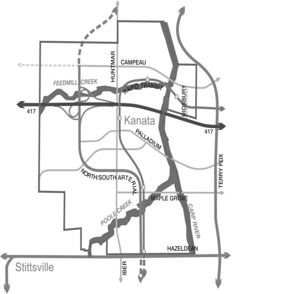
The Kanata West development area straddles Highway 417 around Scotia Bank Place extending south to Hazeldean Road, north along the Carp River to the urban boundary south of Richardson Side Road. The total study area comprises 725 hectares (1791 acres) of land. The site location map is found in Document 1.
On March 26, 2003, Ottawa City Council approved the general land use and development principles of the Kanata West Concept Plan (KWCP). The KWCP is a major component of urban growth in the western portion of the City. It is planned to include a population of approximately 17,000 persons in 6,300 households, 24,000 jobs and approximately 1 million square metres of commercial space. The mix of uses includes office, housing, retail, institutional, entertainment and leisure activities. This scale of development, located between Stittsville and Kanata, is being planned as a mixed-use community. The Concept Plan includes the transportation network, environmental protection and servicing infrastructure required to support the identified land use plan. This includes a rapid transit corridor and a number of primary arterials, minor arterial roads, major collector roads, water, sewers, stormwater management and watercourse corridors.
Following City Council direction, the draft City of Ottawa Official Plan was revised in March 2003 to reflect the Kanata West Concept Plan, and was adopted by City Council on May 14, 2003. The Kanata West Concept Plan is reflected in the following Schedules of the City’s Official Plan:
Schedule B- Urban Policy Plan
• Enterprise Area
• Mixed Use Centre
• General Urban Area
• Major Open Space
Schedule D – Primary Transit Network
• Future Rapid Transit Corridor - alignment to be defined
Schedule E – Urban Road Network
• Extension of Campeau Drive Arterial – conceptual (alignment undefined)
• Extension of Huntmar Drive Arterial - conceptual (alignment undefined)
• North-South Arterial - conceptual (alignment undefined)
• Extension of Maple Grove – proposed major collector (west of Huntmar)
• Maple Grove Arterial (east of Huntmar Road) - proposed (alignment defined)
Schedule I – Major Recreational Pathways & Scenic-Entry Routes (Urban)
• Extension of the major recreational pathways along Poole Creek and Feedmill Creek
• Identification of Carp River Corridor as major recreational pathway
With the approval of the KWCP, developers have been consolidating land ownership in the Kanata West area in preparation for future development. The majority of landowners within Kanata West have formed a group entitled the Kanata West Owners’ Group Inc. to govern the planning and development of this large development area as one corporate body. The Official Plan Amendment to recognize the Kanata West Owners’ Group Inc. as a corporation was approved on March 28th by Planning and Environment Committee. This was confirmed at City Council on April 12, 2006.
It was recognized, by both the City and the Kanata West Owners’ Group, that further work was required to facilitate the Plan of Subdivision process in terms of infrastructure planning and process requirements. The Council approved Carp River Watershed/Subwatershed Study identified the technical study requirements for proposed land use changes in the watershed. Three concurrent and integrated Class Environmental Assessment studies were initiated in the fall of 2004 to provide a master plan for the road network, servicing (water, sanitary, stormwater management) and river and creek restoration projects as recommended in the Carp River Watershed/Subwatershed Study.
The following three Class EA studies were undertaken for the Kanata West Development Area following the Municipal Engineers Association Class Environmental Assessment Process (Class EA):
• Kanata West Master Servicing Plan – Stantec Consulting Ltd., CCL/IBI Group
• Kanata West Transportation Master Plan – Delcan
• Carp River, Poole Creek and Feedmill Creek Restoration Class Environmental Screening Report – Totten Sims Hubicki with Parish Geomorphoric, Stantec Consulting and Beacon Consulting
A Flow Characterization and Flood Level Analysis was also carried out by CH2MHill Canada to update the hydrology and hydraulic model for existing conditions. CH2M Hill also prepared a post development analysis for future build out of the entire subwatershed area draining into the Carp River, Poole Creek and Feedmill Creek. This technical analysis supports the three Class EAs for Kanata West. The existing and post development analysis can be found in an appendix to the Kanata West Master Servicing Plan.
The purpose of this report is to summarize the process and recommended infrastructure projects identified in the three Class Environmental Assessment reports. Although three separate documents have been produced, all the projects have been planned and coordinated as an integrated master plan exercise. Decisions were made in an integrated and iterative process throughout the course of the studies. Through this iterative discussion and consultation many additional tasks and investigations were undertaken to ensure compatibility between the various infrastructure requirements.
DISCUSSION
The City of Ottawa and the Kanata West Owners’ Group (KWOG) are co-proponents for the Class Environmental Assessments. Several plan of subdivision applications were being submitted at the same time as commencing the Class EAs. As such, the KWOG and the City proceeded to follow the integration provision of the Class EA process. It recognizes the benefits of integrating approvals under the Environmental Assessment Act and the Planning Act. Any project which would otherwise be subject to the Municipal Class EA, that meets the intent of the Class EA (Section A.2.9) and receives approval under the Planning Act is considered to be a Schedule A project and may proceed to construction.
However, as a result of comments received from the Ministry of Environment, Environmental Assessment Approvals Branch, the Planning Act and Environmental Assessment Act requirements were separated and the development applications and infrastructure studies proceeded independently. The Plans of Subdivisions are being approved through the Planning Act. The infrastructure and watercourse restoration projects are fulfilling the Environmental Assessment Act requirements through the Class Environmental Assessment process as follows:
Kanata West Transportation Master Plan – Master Plan fulfilling Phases 1-4
§ Huntmar Road Extension from Halzeldean Road to Maple Grove Road (Schedule C)
§ Huntmar Road Widening from Maple Grove Road to Campeau Drive (Schedule C)
§ Campeau Drive from Didsbury Road to North-South Arterial (Schedule C)
§ Maple Grove Road Widening from west of Huntmar Road to Terry Fox Drive (Schedule C)
§ North-South Arterial from Hazeldean Road to Campeau Drive Extension (Schedule C)
§ Stittsville Main Street Extension from Maple Grove Road to North-South Arterial (Schedule C)
Kanata West Master Servicing Plan – Master Plan fulfilling Phases 1 and 2
Sanitary Servicing Projects
§ Kanata West Pumping Station and associated gravity sanitary sewers (Schedule B)
o Permanent Twinned Force main to the Tri Party Collector
o Trunk Sanitary from Silver Seven, & along Carp River between Maple Grove Road and Palladium Drive
§ Signature Ridge Pump Station Upgrade and associated gravity sanitary sewers (Schedule B)
Watermain Projects
§ Watermains in Huntmar Road Extension from Halzeldean Road to Maple Grove Rd. (Schedule B)
§ Watermains in Huntmar Road Widening from Maple Grove Road to Campeau Drive (Schedule A)
§ Watermains in Campeau Drive from Didsbury Road to North South Arterial (Schedule B)
§ Watermain in Maple Grove Road from Stittsville Main Street to Terry Fox Drive (Schedule B)
§ Watermains in North-South Arterial from Hazeldean Road to Campeau Drive Extension (Schedule B)
§ Watermains in Stittsville Main Street Extension from Maple Grove Road to Palladium Drive (Schedule B)
Stormwater Management Projects
§ Stormwater Management Pond # 1 and associated storm sewers (Schedule B)
§ Stormwater Management Pond # 2 and associated storm sewers (Schedule B)
§ Stormwater Management Pond # 3 and associated storm sewers (Schedule B)
§ Stormwater Management Pond # 4 and associated storm sewers (Schedule B)
§ Stormwater Management Pond # 5 and associated storm sewers (Schedule B)
§ Stormwater Management Pond # 6 and associated storm sewers (Schedule B)
§ Stormwater Management Pond # 7 and associated storm sewers (Schedule B)
• Carp River, Poole Creek and Feedmill Creek Restoration Class Environmental Screening Report – fulfilling Phases 1& 2
• Carp
River full restoration and Poole Creek and Feedmill Creek local restoration
project (Schedule B)
A summary of the study methodology, analysis and recommended projects for each of the Class EAs is provided below.
Kanata
West Transportation Master Plan
The Kanata West Land Owners’ Group, representing the major landowners within the Kanata West Development Area has completed a Class Environmental Assessment (EA) Study for the major road network required to provide appropriate transportation service to the lands designated for urban development in the Kanata West Concept Plan. Ottawa City Council approved the Kanata West Concept Plan in March 2003, and the major road network identified at that time included:
• Campeau Drive Extension: Didsbury Road to Palladium Drive;
• Maple Grove Road Widening: Terry Fox Drive to Huntmar Drive;
• Relocated Maple Grove Road: West of Huntmar Drive;
• Huntmar Drive Widening and Extension: Palladium Drive to Hazeldean Road; and
• North-South Arterial: Palladium Drive to Hazeldean Road.
The concept plan also identified the extension of the West Rapid Transit corridor west of Kanata Centrum through the Kanata West Development Area (KWDA) to Hazeldean Road.
While recognizing that the rapid transit corridor will require an Individual Environmental Assessment, alternative corridors were evaluated and a preferred corridor identified as part of the Master Plan (Phases 1&2) to ensure that the best combinations of road and rapid transit links were identified for long-term corridor protection.
Alternative Transportation Solutions
Drawing on the recently completed Transportation Master Plan (2003), and the updating of the technical analysis in support of the Kanata West Concept Plan (2002), the preferred alternative solution to meet the long-term transportation system requirements of the Kanata West Development Area, as approved by Ottawa City Council, includes a combination of TDM/TSM measures, improved transit (including rapid transit), road widenings and new roads.
The principal elements of the future transportation network include:
• Rapid transit corridor from Kanata Centrum west to Scotia Bank Place and south to Hazeldean Road;
• Extension of Campeau Drive as a four-lane arterial (4-UAD) from Didsbury Road to Palladium Drive;
• Widening of Maple Grove Road to four-lanes (4-UAD/4-UAU) from Terry Fox Drive to Huntmar Drive;
• Widening of Huntmar Drive as a four-lane arterial from Palladium Drive to Maple Grove Road;
· Extension of Huntmar Road as a two/four lane arterial from Maple Grove Road to Hazeldean Road; and
• Construction of the North-South Arterial as a four-lane arterial from Palladium Drive to Hazeldean Road; and
• Stittsville Main Street extension as a two-lane major collector connecting the North-South Arterial to the proposed Jackson Trails subdivision, west of the KWDA.
Alternative Transportation Design Concepts
Rapid Transit Corridor: North of Highway 417 two conceptual rapid transit corridors were identified, one north of and one south of Feedmill Creek. Over Highway 417 and within the Scotia Bank Place lands to the south, one alternative location was identified, while further south between Palladium Drive and Hazeldean Road three alternatives were evaluated, representing central, easterly and westerly corridor locations.
Campeau Drive Extension: Two alternative corridors were evaluated each representing a potential pairing with one of the rapid transit alternatives.
Maple Grove Road Widening: Three alternative widenings were identified based on equal widening on either side of the existing centerline or widening totally to the north or south of the existing right-of-way.
Huntmar Drive Widening: As with Maple Grove Road, three widening alternatives were identified, equally about the existing centerline or totally to the east or west of the existing right-of-way.
Huntmar Drive Extension: Only one alternative was identified for the extension of Huntmar Drive within the proposed Mattamy Homes Subdivision south of Maple Grove Road, as the end points of this link at Maple Grove Road and at Hazeldean Road were already fixed.
North-South Arterial: Two alternative corridors were identified. One intersected with existing Huntmar Drive north of Maple Grove Road while the second intersected with the Huntmar Drive Extension within the proposed Mattamy Homes Subdivision, south of Maple Grove Road.
Stittsville Main Street Extension: Two alternatives, differing in length only, were evaluated in conjunction with one or other of the two North-South Arterial alternatives.
Evaluation of Transportation Alternatives
The alternatives for each link in the transportation network were evaluated using a paired comparison evaluation approach, based on four broad criteria groups: Social Environment, Physical Environment, Biological Environment and Transportation Environment, with each group further broken down into a number of criteria.
The result of the evaluation process was a preferred network comprised of the following projects recommended for approval as per Recommendation 1 of this report:
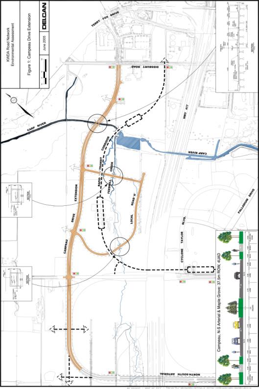
· Campeau Drive Extension/Rapid Transit Corridor: In combination with, and generally parallel to the conceptual rapid transit corridor north of Feedmill Creek, the preferred alignment for Campeau Drive reflects an adequate amount of physical separation to enable appropriate blocks of residential development to occur in proximity to a future rapid transit station with a resultant alignment that is considered to be more harmonious with the residential land use within which it will be located. The conceptual corridor for the Transitway has been identified as part of this process to address and identify an integrated transportation system, however, the final alignment for the transitway will be evaluated during the East-West Light Rail Corridor Individual EA, currently under way. (FIGURE 1, Document 2).
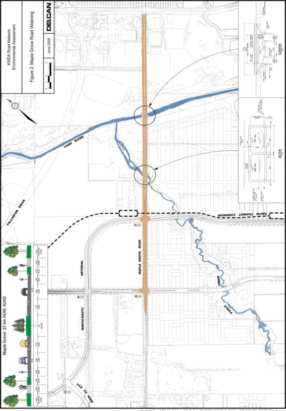
· Maple Grove Road Widening: Widening about the centerline was preferred in order to tie into the existing alignment at Terry Fox Drive, to equalize property impacts, and to facilitate right-of-way acquisition (FIGURE 2, Document 2).
.
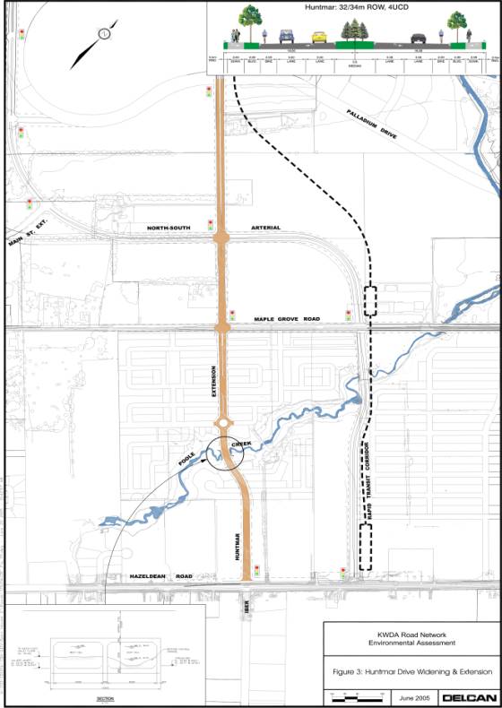
· Huntmar Drive Widening: Again, widening about the centerline was preferred to tie into the existing four-lane cross-section north of Palladium Drive, to equalize property impacts and to facilitate right-of-way acquisition (FIGURE 3, Document 2).
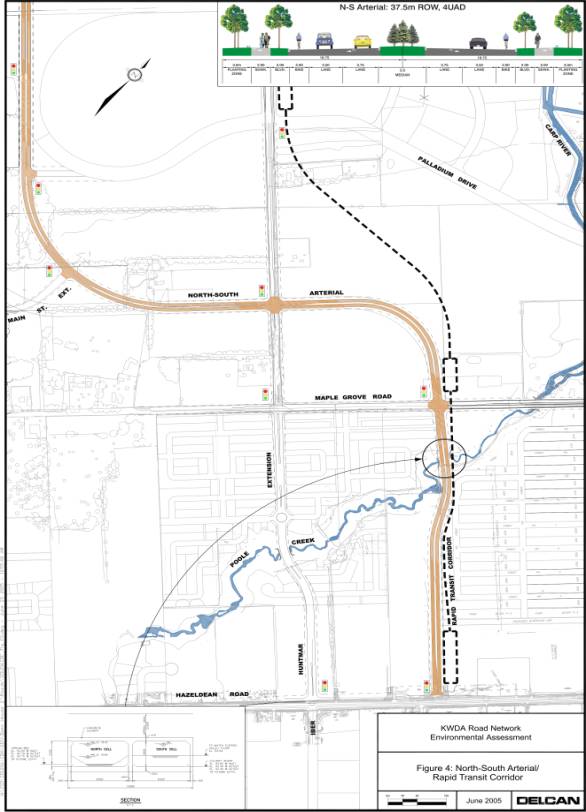
· North-South Arterial/Rapid Transit Corridor: The alternative that results in a corridor north of Maple Grove Road as a boundary between residential and mixed-use land uses, while removing the major intersection with Huntmar Drive from within residential development south of Maple Grove Road, was preferred. In conjunction with the preferred centrally based conceptual corridor for the rapid transit corridor south of Palladium Drive, the combined corridors will provide an acceptable separation between the proposed Mattamy Homes and Richcraft Home residential development south of Maple Grove Road (FIGURE 4, Document 2).
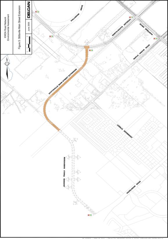
· Stittsville Main Street Extension: The preferred North-South Arterial results in the shorter of the two alternatives for the relocated Maple Grove Road to the west being preferred (FIGURE 5, Document 2).
Kanata
West Master Servicing Plan
The Kanata West Master Servicing Plan serves as an update to the 2002 Concept Plan prepared by FoTenn Consulting. The objective of the study is to provide, at a macro level, a servicing plan for the Kanata West Development Area (KWDA) identifying an internal servicing scheme for water, sanitary and stormwater that supports the land uses and development densities within the subject area. The principal recommendations of the master servicing study are discussed below.
Sanitary Servicing Alternatives
The sanitary servicing plan for the Kanata West area identified the following main components of the system to be investigated: 1) Off-Site Wastewater Outlet; 2) Internal Pumping Station and Associated Gravity Sanitary Sewers; 3) Temporary Forcemain; 4) Gravity Sewer to service Hazeldean Road and the southern portion of KWDA; and, 5) Signature Ridge Pumping Station Upgrade. A description of the alternatives considered for each component is described below.
Off-site Wastewater Outlet Alternatives: Two options were considered to outlet the wastewater system for Kanata West to its designated outlet, the Glen Cairn Collector Sewer: 1) Gravity; and 2) a Combination of Pumping and Forcemain. One gravity alignment was identified and two forcemain alignments were considered. The locations were generally based on the available corridors through the existing communities to the east, which lies between Kanata West and the designated outlet. The three alternative outlet alignments are:
· Gravity sewer (tunnel) along the 417 corridor to the Tri Township sewer
· A forcemain along the 417 corridor from Silver Seven Road to the Glen Cairn Collector sewer east of Eagleson Road
· A forcemain along Katimavik Road and Palladium Drive from Silver Seven Road to the Glen Cairn Collector Sewer east of Eagleson Road
Internal Servicing Alternatives: Three potential locations for the Kanata West Pumping Station were identified with associated trunk sewer corridors connecting to the existing First Line Road Sewer: 1) Silver Seven Road at Hwy 417; 2) Hwy 417 east of Carp River; and 3) Maple Grove Road west of the Carp River (two proposed trunk sewer alignments).
Temporary Pumping Station Alternatives: Three potential alignments were considered for a temporary forcemain, which will be required to service the initial phases of development. The locations are based on available corridors through the existing community to reach the temporary outlet, the Stittsville Collector Sewer. The three alternative forcemain alignments are:
· Maple Grove Road, Huntmar Road and Iber Road to the temporary outlet, the Stittsville Collector Sewer at the south end of Iber Road
· South, parallel to the west side of the Carp River, through the proposed development to the Glen Cairn stormwater pond, east to Terry Fox Drive, and southerly along Terry Fox Drive to the Stittsville Collector.
· East on Maple Grove Road to Terry Fox Drive and southerly on Terry Fox Drive to the Stittsville Collector.
Huntmar Road Gravity Sewer: Three potential alignments were considered for a gravity sewer, which will service currently unserviced lands on Hazeldean Road and provide the potential to decommission several small existing pumping stations along the northern limit of the Village of Stittsville. The three alternative alignments are:
· Maple Grove Road from the proposed pumping station at Huntmar Road, Huntmar Road to Hazeldean Road at Iber Road
· Maple Grove Road to south of Poole Creek, southerly along Poole Creek to the transit corridor, southerly along the transitway to Hazeldean Road, and Hazeldean Road to Iber Road
· South from Maple Grove Road Pumping Station through the proposed development to Hazeldean Road, and west on Hazeldean Road to Iber Road
Signature Ridge Pumping Station: Two alternatives were considered for the Signature Ridge Pumping Station: 1) Upgrade station to satisfy drainage requirements, or 2) Rebuild. These alternatives were considered because of the significant amount of existing infrastructure that depends on Signature Ridge Pumping Station for an outlet and the proximity of this pumping station to the northeast portion of the Kanata West development area.
Evaluation of Sanitary Alternatives
The alternatives for each component of the wastewater system were evaluated and ranked using a standard pair-wise comparison methodology, based on four broad criteria: Constructability/Functionality; Economy, Caring and Healthy Communities and Natural Environment, with each group further broken down into a number of criteria.
The results of the evaluation process was a preferred sanitary servicing system comprised of the following projects recommended for approval as per Recommendation 1 of this report:
Off-Site Wastewater Outlet - Permanent Twinned Forcemain to the Tri Party Collector.
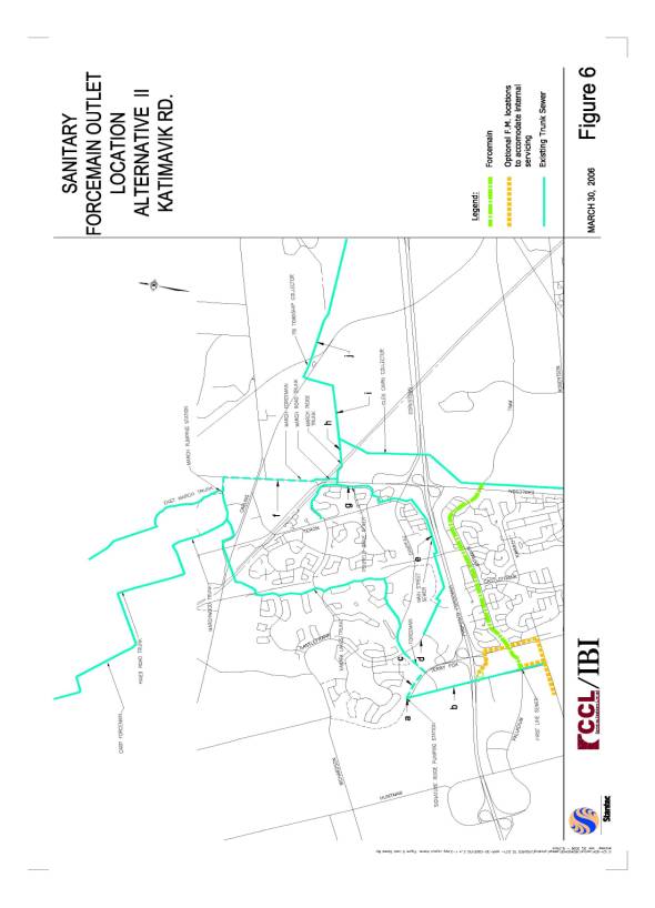
The second forcemain alternative, the Katimavik Road alignment, was selected as the permanent outlet for the new Kanata West Pumping Station and associated trunk sewer linking it to the Tri Party Collector. This option offers the most flexibility for internal servicing design, uses a lower road classification corridor which simplifies routine maintenance operations and provides maximum separation distance from the ANSI (Area of Natural or Scientific Interest) located in the 417 corridor east of Terry Fox Drive (FIGURE 6, Document 2).
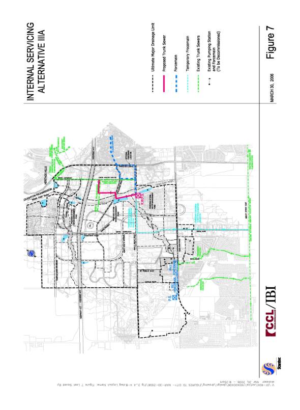
Internal Servicing - Kanata West Pumping Station at Maple Grove Road, west of Carp River and associated trunk sanitary sewer from Silver Seven along Carp River between Maple Grove and Palladium Drive. Option 3 (FIGURE 7, Document 2) was selected as it will be designed with the capacity to allow decommissioning of up to eight small public and private pumping stations along Hazeldean Road. Temporarily the Kanata West pumping station will outlet to the Stittsville Collector Sewer via a temporary forcemain in Huntmar Road and Iber Road (Alternative 1). This temporary forcemain is designed to accommodate 200 l/sec (approximately 3,000 units). The location of the new pumping station is in close proximity to Stormwater Management Ponds 4 and 5 providing an opportunity to provide catastrophic failure protection to the new pumping station in the form of a gravity overflow.
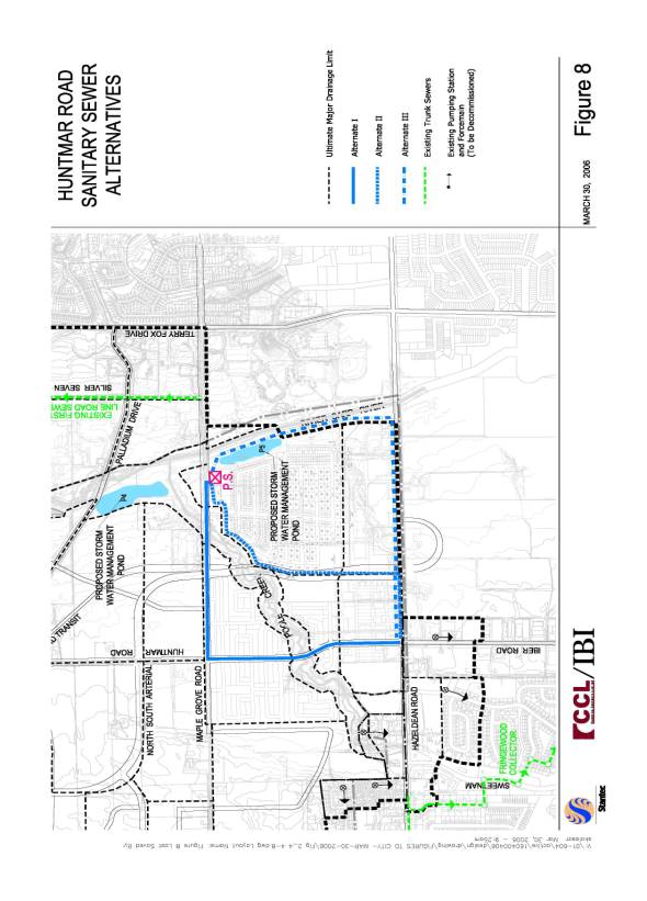
Huntmar Road Gravity Sewer: Alternative 1 along Huntmar Road, east along Maple Grove to the new Kanata West pump station was selected as the preferred alignment (FIGURE 8, Document 2). This gravity sewer will collect flow from several minor internal sanitary sewers and directs this flow to the new pumping station location. The inclusion of this north-south sewer is a key element in eliminating the need for double pumping within Kanata West and also facilitates the decommissioning of the Corel Centre siphon.
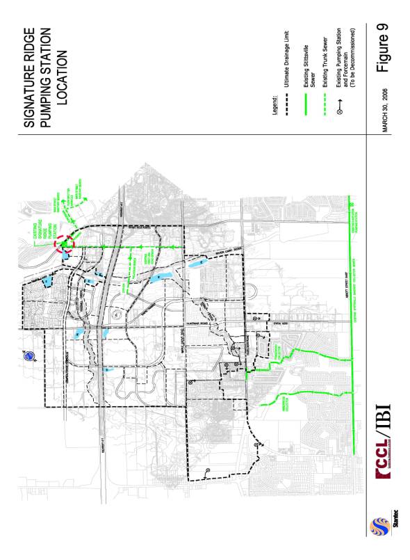
Signature Ridge Pumping Station: An upgraded Signature Ridge Pumping Station (SRPS) was selected as the preferred option to service all the Kanata West lands north of the Queensway, the existing urban area north of the Queensway currently proposed to drain to the SRPS, and the Broughton/Richardson and Interstial lands (FIGURE 9, Document 2). Presently the City is undergoing a SRPS and Forcemain Upgrades Feasibility and Preliminary Design Studies to determine the best alternative for the upgrade. This study is expected to be completed in Spring of 2006.
In order to implement this servicing plan effectively it will be necessary to provide regular flow monitoring at the Stittsville Collector Sewer, the Hazeldean pumping station, and the Signature Ridge Pumping station, to ensure that the ultimate works are designed and constructed in time to allow a continuous building program throughout the build out of the Kanata West development area.
The preferred sanitary system provides a flexible cost effective servicing scheme that allows for phased construction of the new wastewater infrastructure by making use of residual capacity in the existing infrastructure and maximizing the potential of this existing infrastructure. The ultimate servicing scenario also increases the efficiency of the City’s overall wastewater system by minimizing the number of new pumping stations and facilitating the ultimate decommissioning of up to eight existing public and private pumping stations and one siphon. The proposed sanitary sewer system has been designed in conjunction with the storm sewer system and water system to provide a coordinated cost effective system with maximum flexibility to accommodate the orderly and staged development of the entire Kanata West area. The proposed sanitary sewer system also recognizes inefficiencies in the existing sanitary sewer system, outside the Kanata West development area, and is designed to provide flexibility in the ultimate system to cost-effectively maximize the efficiency of the overall wastewater system.
Watermain Alternatives
The objective of the water supply assessment is to update the "internal" water servicing requirements within the approved Kanata West Concept Plan and determine the operability of the system under different demand scenarios. Watermain corridors were identified and linked with transportation corridors in order to reduce the construction impacts of new utility corridors. All watermains are proposed to be located within identified transportation corridors.
The preferred wastewater system is comprised of the following projects recommended for approval as per Recommendation 1 of this report:
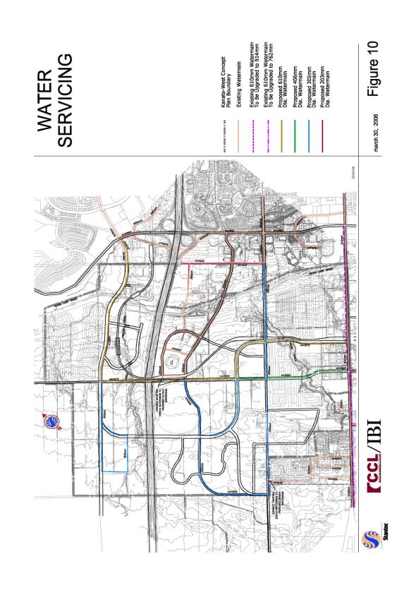
A 610mm watermain loop is proposed to be located within the north south arterial corridor from Hazeldean to Huntmar, north within the Huntmar right-of-way to Campeau Drive, east within the defined Campeau Drive right-of-way tying into the existing watermain at Campeau and Terry Fox. This sizing considers peak daily demands, fire flow requirements and reliability needs (FIGURE 10, Document 2). This watermain will provide a strong loop through the proposed development area, and most importantly, will provide appropriate redundancy for the major transmissions on Hazeldean Road. This 610mm watermain will provide sufficient conveyance capacity between Kanata and Stittsville to allow flexibility in operating Pressure Zone 3W by allowing water pump station discharge pressures to be reduced while maintaining adequate pressures in the Stittsville area.
A 406mm diameter watermain at south end of the proposed Huntmar, within the proposed right-of-way and looped 305mm diameter watermains within defined road right-of-way as shown in the figure, will be needed in different parts of the Kanata West Concept Plan area to provide adequate domestic and fire flow demands. Other looped pipes will be required within individual growth areas, and it is expected that these pipes will range in size from 152mm to 305mm in diameter (Figure 10, Document 2).
Stormwater Management Alternatives
The Master Servicing Plan confirmed the need for water quality control for new developments in order to limit the transport of contaminants to the receiving watercourses. Based on the recommendations of the Carp River Watershed/Subwatershed Study (CRWSS) and utilizing the Ministry of Environment Stormwater Management Planning and Design Manual Guidelines, end-of-pipe wet ponds are required to meet the water quality design criteria. Four stormwater management alternatives were identified: 1) Do Nothing; 2) 10 pond option presented in the CRWSS; 3) 5 pond option presented in the KWCP and CRWSS; and 4) hybrid of options 2 and 3 which include, 5 ponds outletting to the Carp River and 2 ponds outletting to Feedmill Creek.
Evaluation of Stormwater Management Alternatives
The four alternatives were evaluated using a standard pair-wise comparison methodology, based on four broad criteria: Constructability/Functionality; Economy, Caring and Healthy Communities and Natural Environment, with each group further broken down into a number of criteria.
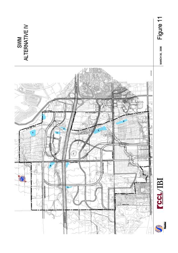
Based on the results of the evaluation process, option 4 was selected as the preferred stormwater management servicing plan for the KWDA. This option offers the most flexibility and phasing opportunities while providing an economical solution. The solution also meets the requirements of the Carp River Watershed/Subwatershed study. The preferred stormwater management system consists of the construction of the following seven end-of-pipe wet pond facilities (FIGURE 11, Document 2) recommended for approval as per Recommendation 1 of this report:
§ Pond 1 adjacent to the Carp River and downstream of Campeau Drive will service the future residential lands between the Carp River, Campeau Drive and Huntmar Road, as well as an area of extensive employment between Feedmill Creek and Campeau Drive. Normal and 100yr water levels in the pond are 92.70 and 93.96, respectively.
§ Pond 2 is proposed just upstream of the confluence of Feedmill Creek and the Carp River on the south bank and will service future extensive employment and high profile employment lands between Feedmill Creek and Highway 417. Normal and 100yr water levels in the pond are 93.25 and 94.23, respectively.
§ Pond 3 is proposed on the north bank or the Carp River between the future transitway and Highway 417. It will service low density business park and community retail lands between Didsbury Road and the Carp River. Normal and 100yr water levels in the pond are 92.90 and 94.20, respectively.
§ Pond 4 adjacent to the Carp River is proposed just upstream of Palladium Drive and downstream of the Poole Creek confluence with the Carp River and will service a mixed use area bound by Pool Creek, Palladium Drive and the Kanata West Community Boundary. Normal and 100yr water levels in the pond are 93.25 and 94.74, respectively.
§ Pond 5 is proposed upstream of the confluence of Poole Creek and the Carp River along the south-west bank of the Carp River. Pond 5 will service residential and retail developments between Poole Creek, the Carp River and Hazeldean Road. Normal and 100yr water levels in the pond are 93.44 and 94.94, respectively.
§ Pond 6 is to be located north-east of Feedmill Creek at the intersection with Huntmar Road and will service business park and extensive employment developments. Normal and 100yr water levels in the pond are 98.00 and 98.94, respectively.
§ Pond 7 is proposed south of Highway 417 and west of the future north-south arterial and will service business park and extensive employment lands. Normal and 100yr water levels in the pond are 102.20 and 102.92, respectively.
As part of all stormwater management facility designs, a detailed maintenance and monitoring program is required to maintain the operational efficiency and functionality of the facility, while monitoring its long-term performance in relation to the proposed design, as stipulated in the MOE Certificate of Approval for each facility.
The City's "Ottawa Sewer Design Guidelines (January 2005)" were used to design the storm sewer system associated with the stormwater management facilities. The minor system is designed according to either a 5 year (local roadways) or to a 10 year level of service (arterial roadways) without surcharge. The minor system is also designed to operate under limited surcharge in the 100 year event such that a minimum clearance of 0.3m exists between the building footings and the hydraulic grade line (HGL). The alignment and size of the trunk sewers were established applying the City's guidelines considering the proposed road layout, tributary areas to respective sewers and issues pertaining to the 100 year hydraulic gradeline elevations.
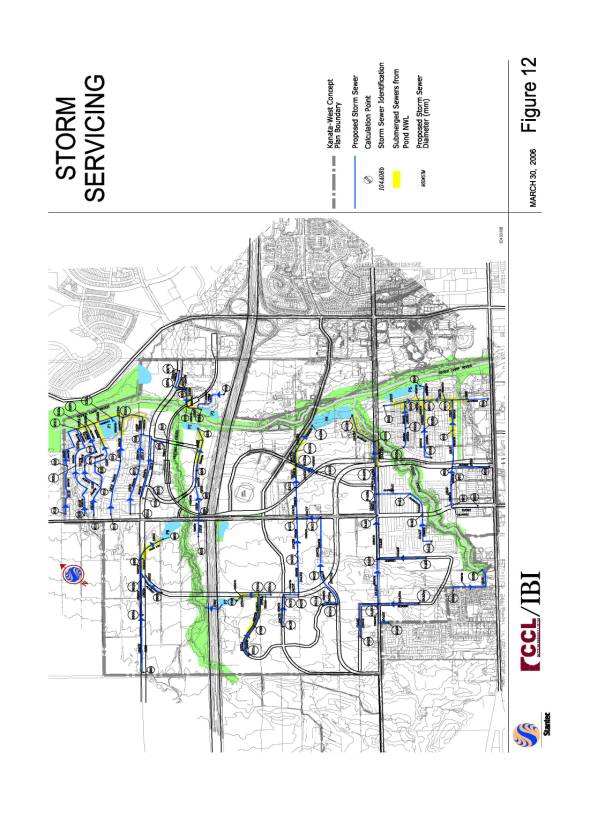
The storm servicing system to support the stormwater management solution is illustrated on Figure 12 of Document 2. The preferred storm sewer projects associated with each stormwater management facility are being recommended for approval as per Recommendation 1 of this report. To service the area adjacent to the Carp River, large diameter sewers laid at flat grades were required. The hydraulic grade line analysis completed provides protection for all units in accordance within the Kanata West development meeting City design guidelines. The preferred trunk sewer sizes and locations have all been designed in accordance with the City of Ottawa design guidelines. The preferred cover requirement of 2.0 m is not met in all locations, specifically where the grade falls towards the Creeks and River. To provide a gravity connection from the foundation drains to the storm sewer, a grade raise in combination with more exposed foundation or a modified building structure (i.e. walkouts, split level homes) may be needed.
Existing
Condition And Post Development Hydrology And Hydraulic Analysis
A hydrologic and
hydraulic analysis has been completed for the Carp River, Poole Creek and
Feedmill Creek tributaries. This analysis included all areas upstream of the
Village of Carp, including the proposed Kanata West Development Area and future
development as identified in the City of Ottawa Official Plan. The purpose of
the analysis was intended to understand the cumulative impact of the proposed
transportation network, the land use, servicing requirements and restoration
project for the Carp River, Poole Creek and Feedmill Creek within Kanata
West. The analysis needed to address
the concern that proposed changes as a result of the Kanata West development
and associated infrastructure, and Carp River restoration project may result in
an unacceptable impact to flood levels and flows in the Upper Carp River
watershed.
The analysis was
completed in three steps. The initial step was to characterize the existing
flows and water levels in the river systems based on current land use,
topography, soil cover, hydraulic structures, and surveyed cross-sections of
the channels. This base condition was then compared with the condition under
the full build out of the Kanata West community including the revised flood
corridor, channel restoration, new road crossings, and altered drainage
patterns and discharges to the Carp River, Poole Creek and Feedmill Creek.
Thirdly, the analysis was extended to include the complete ultimate build out
of the Official Plan including the development of the Broughton lands, the
partial floodplain encroachment proposed under the Terry Fox extension, and the
proposed new Hazeldean crossing of the Carp River.
The
methodology for the hydrologic analysis made use of the XP-SWMM and
QUALHYMO model to generate inflow hydrographs to the various river. The hydraulic analysis for the Carp River
used the unsteady state option of HECRAS. This takes into account the effect of
channel storage and routing along the flat gradient of the channel. The steady
state flow option of HECRAS was applied for Poole Creek and Feedmill
Creek. The inflow hydrographs
were then routed in a hydraulic model HECRAS to generate computed water levels,
flows and velocities. Flows and water levels were checked by using actual water
levels measured during the September 9, 2004 storm events, as well as a
sensitivity analysis of hydrologic parameters.
The results of the analysis indicate the Kanata West Development and floodplain encroachment will result in an increase of 0.04m increase in the 100 year water level immediately upstream of Richardson Side Road, and a reduction in water level of 0.12m at Highway 417. The full build out of the Official Plan and floodplain encroachment will result in an increase of 0.11m upstream of Richardson Side Road, and no change in water level at the Highway 417. Water levels upstream of Palladium Drive will increase by a maximum of 0.07m as a result of Kanata West build out, and a maximum of 0.18m as a result of the complete build out of the Official Plan. The full build out of the Official Plan and floodplain encroachments will result in a maximum increase of 0.04m downstream of Richardson Side Road in the rural area. Predicted flow velocities downstream of Richardson Side Road will be below erosion thresholds
The Mississippi Valley Conservation Authority has reviewed and supports the hydrologic and hydraulic analysis that has been completed.
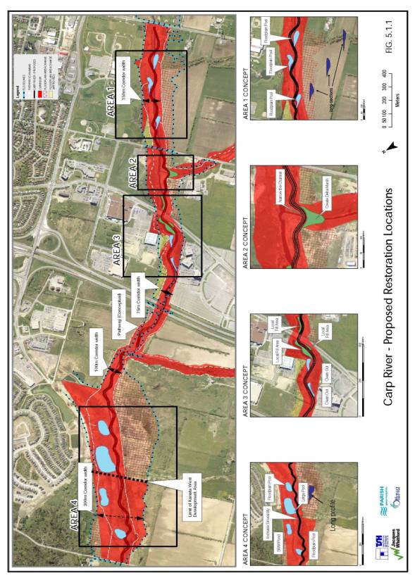
Carp
River, Poole Creek, And Feedmill Creek Restoration
The Council approved Carp River Watershed/Subwatershed study recommended restoration and enhancement of the Carp River, Poole Creek, and Feedmill Creek. The purpose of the Class Environmental Assessment study was to develop, evaluate and recommended preferred rehabilitation alternatives for Carp River, Poole Creek and Feedmill Creek within the Kanata West development area. The need for the restoration was identified in the subwatershed study. This section of the Carp River is very degraded as it has been subject to historical straightening which has resulted in significant sediment accumulation on the channel bed. This has resulted in degraded water quality and aquatic habitat. Poole Creek and Feedmill Creek support tolerant cold water fish community and diverse warm water fishery. However, both creeks are experiencing bank undercutting and erosion which are impacting the stability and function of the stream channel in certain sections. The accumulated sediment build up in the Carp River is impacting the mouths of Poole and Feedmill Creeks.
The purpose of the Class EA study was to develop a preferred alternative and conceptual design for the Carp River including Poole Creek and Feedmill Creek. The conceptual design of the Carp River is to be situated within the proposed 100 metre minimum corridor as outlined in the Carp River Watershed/Subwatershed study.
Further field investigations were carried out in the areas of terrestrial, aquatic, and fluvial geomorphology. The existing conditions of the creek corridors were characterized building upon the work carried out in the watershed/subwatershed study. The fieldwork findings and analysis confirmed the degraded condition of the Carp River and problematic areas within the Poole Creek and Feedmill Creek.
Restoration Alternatives
Alternatives were developed using a two-phased approach. The first phase involved the development of preliminary alternatives and a coarse screening process. The second phase refined the preferred preliminary alternative to generate more detailed alternatives. The physical constraints associated with the Carp River limited the options available, however the following alternatives were considered for all three watercourses:
• Do Nothing
• Harden Channel (concrete lined portions of channel, armourstone bank enhancements, rip rap revetments)
• Natural Channel Design
Based on the preliminary screening, it was determined that the Do Nothing and Harden Channel options would not meet the project objectives. The Natural Channel Design preliminary alternative was selected and further refined into two more detailed alternatives:
• Local Restoration – provides the opportunity for enhanced geomorphic or environmental conditions in identified areas of need; and,
• Full Restoration – provides for enhanced geomorphic and environmental conditions. This tends to be a large-scale work, where the channel can be moved, realigned and designed to incorporate more channel elements (pools and riffles).
Both alternatives were evaluated for the Carp River. Based on observed degraded conditions of the Carp River throughout the study area, local restoration opportunities would not serve to sufficiently address the issues or project objectives. Stabilization and enhancement requirements/opportunities exist throughout the entire study area for the Carp River. Using the principles of natural channel design, the desired outcome for a full restoration would include:
• Increased sinuosity and river stability
• Reduced channel width by 20-25%
• Riparian enhancement and biodiversity
The full restoration alternative will meet the study objectives with respect to sediment transport, erosion control, flow conveyance/flow regime and environmental enhancement.
Poole Creek and Feedmill Creek were evaluated for both the local and full restoration alternatives. Based on the observed high quality characteristics of Poole Creek and Feedmill Creek, local restoration would provide the opportunity to enhance and stabilize the areas of concern while leaving other areas undisturbed.
Carp River Preferred Alternative
As per Recommendation 1 of this report, the preferred full restoration alternative for the Carp River is being recommended for approval. (FIGURE 13, Document 2). The preferred restoration project includes a change to the channel cross-section and planform as well as the following design elements:
• Increased sinuosity (channel length) by approximately 10%
• Reduction in channel cross-section
• Planform will accommodate ecological features such as ponds and deltas
• Proposed “nested” set of channels to improve sediment transport
• Narrow section also permits the use of more varied substrate
• Use “reference’ section near Feedmill confluence
• Upstream area may involve some bed treatment to raise invert and increase local gradient
• Incorporate gravel-cobble shoals and some pools to vary substrate and offer more diverse habitat
• Plant riparian vegetation along corridor to restore corridor function and create wildlife habitat
• Pedestrian pathway throughout the entire length of the river as part of larger regional pathway system and local system
The Carp River corridor varies from the existing 75 metre to intervals of 100 m, 150m, 200m, and 250 metres. The Carp River flood plain, in many locations, is greater than 100 m and downstream (north) of Highway 417 the existing flood plain width is narrower than 100 m. The floodplain encroachments represent approximately 28 hectares and 15% total loss of existing flood plain storage for the reach between Richardson Side Road and Hazeldean Road.
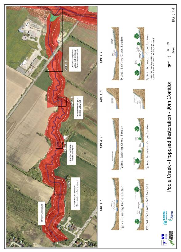
Poole Creek Preferred Alternative
Local improvements along the Poole Creek corridor is being recommended for approval as per Recommendation 1 of this report. Along Poole Creek, there are four areas along the creek corridor that require local improvements as illustrated on Figure 14 of Document 2. Local improvements include channel realignment, removal of island and narrowing of channel, removal of debris and old bridge, valley wall treatment, creation of a delta marsh and riparian plantings.
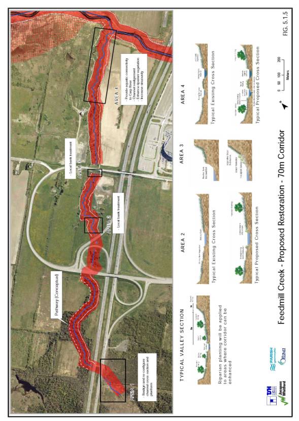
Feedmill Creek Preferred Alternative
Local improvements along Feedmill Creek is being recommended for approval as per Recommendation 1 of this report. For Feedmill Creek, there are four areas along the creek corridor that require local improvements as illustrated on Figure 15 of Document 2. Local improvements include channel realignment, increased sinuosity, aquatic connections to the Carp River, local bank treatment and riparian plantings.
A monitoring plan will be prepared and implemented to evaluate the performance of the design and mitigation techniques over the short and long term.
RURAL IMPLICATIONS
The Kanata West development area is situated upstream of the rural area. The development area drains into the Carp River that flows downstream into the adjacent rural area. Through public consultation, rural residents expressed concerns related to downstream impacts of urban development as it relates to flows and velocities in the Carp River. In order to address these concerns, additional investigations and analysis was undertaken. Sixteen (16) additional cross sections were surveyed and structure information was updated. QUALHYMO was used to generate hydrographs and the existing conditions model was updated.
The results of the post development analysis show that there is a maximum 0.02m (20 mm) increase in 100 year water level downstream of Richardson Side Road with a 0.01 m increase downstream of March Road. Upstream of Huntmar Road (east side), a 0.04m increase in 100 year water level is shown under future built out conditions. The water level increases are not deemed significant. The 100 year water levels at Carp Road match water levels under existing conditions.
The low flow velocities for existing and future conditions were modeled for the 2, 5 and 10 year storm events to assess erosion potential. Consideration was given to the soils and bank types along the watercourse. The banks are primarily clay and loam and the modeled velocities do not approach velocities that would create erosion for this type of bank.
ENVIRONMENTAL IMPLICATIONS
The recommended projects have been identified through a Class Environmental Assessment process. As such, the environmental conditions, impact assessment, mitigation and monitoring measures have been accounted for in determining the preferred alternatives.
The Carp River, Poole Creek and Feedmill Creek restoration project will provide an overall environmental enhancement to the feature and function of the river system in terms of aquatic habitat improvements, terrestrial corridor improvements and river function as it relates to conveyance and sediment transfer.
CONSULTATION
The consultation program included the following activities fulfilling the consultation requirements specified in the MEA Class EA document for Schedule B and C projects:
• Establishment of core Study Team to guide and prepare Class EAs
• Bi-weekly Study Team meetings
• Regular meetings with the three Ward Councillors throughout the course of the study
• Three Public Meetings
• Individual meetings with individuals, interest groups and community organizations
• On-going response to public inquiries and questions
• Individual and collective meetings with provincial and federal agencies to discuss technical information requirements and comments
The
main concerns expressed by the public were associated with the Carp River
restoration project and the proposed floodplain encroachments. The Sierra Club, Ottawa Riverkeeper, Friends
of the Carp, Greenspace Alliance (“the Coalition”) and other individuals
primarily expressed these concerns.
Additional technical work was commissioned and information was presented
at additional meetings with interest groups and individuals to discuss their
concerns.
All technical and policy
related comments received from the Provincial agencies have been addressed by
the Study Team (MVC, City of Ottawa Staff and the KWOG representatives and
consultants). A series of meetings took
place on December 5, 2005, March 7, 2006 and March 20, 2006 to resolve comments
received by the agencies. These
meetings resulted in concurrence between the Study Team and the agencies
regarding their concerns. The
additional technical information and analysis agreed to by the agencies has
been incorporated into the Class EAs such that the City and KWOG can proceed
with completing the Class EA process.
The three Class Environmental Assessments will be finalized after City Council approves the recommended projects for the Kanata West Development Area. Notices of Completion will be published for the three Class EAs notifying the public of the availability of the reports and the 30-day public review period.
FINANCIAL IMPLICATIONS
Infrastructure Projects
The roads and servicing infrastructure, identified in
the Council approved Kanata West Concept Plan and refined in the Class
Environmental Assessment, for the most part will be designed and constructed by
the Kanata West Owners Group. There
will be an operational impact to the City as this infrastructure is put in
service through the regular development process. Several of the projects as
referred to above are listed in the City's Development Charge By-Law and will
be subject to budget approval by City Council through the annual budgeting
process and/or through City's approved Front-Ending Policy in conjunction with
the City approved Long Range Financial Plan. It should be noted that stormwater
management ponds and trunk storm sewers were requested by the Kanata West Owner
Group to not be included in the Development Charge By-Law and as such are the
financial obligation of the Kanata West Owners Group and they not eligible for
Development Charge funds. Development
charges do not apply to the watercourse restoration projects. As such, the
funding mechanism for the watercourse restoration project is described below.
Watercourse Restoration Project
The
Kanata West Owners’ Group will pay for the restoration works associated with
Poole Creek and Feedmill Creek. The
Kanata West Owners’ Group will also pay for the detailed design contract for
the Carp River restoration project. The
construction of the Carp River restoration project is estimated to cost
$5,000,000.00. A cost sharing formula
has been established whereby the total costs of the project would be
distributed as follows:
• 30% -
City
• 45% -
adjacent landowners
• 25% -
remaining Kanata west landowners
The Carp River restoration project benefits Ottawa
residents at large as well as the Kanata West and adjacent developments. The landowners would pay 70% of the
restoration costs with 30% of the costs attribute to the City. Based on this cost sharing formula, the cost
of the restoration project would be distributed as follows:
• $1,500,000
- City
• $2,250,000
- adjacent development
• $1,250,000
- remaining Kanata West landowners
The
Carp River Restoration project is currently defined in capital account
#903940. The balance of the City's
portion of the restoration project will be established through the 2007
budgetary process.
SUPPORTING DOCUMENTATION
Document 1 Site Location Map
Document 2 Figures
Document 3 Public Consultation Summary
DISPOSITION
1. City Staff and KWOG will finalize the Class Environmental Assessment Reports and file the Notice of Completions to initiate the 30-day public review period.
2. City Staff will identify projects through budget process and Development Charges.
3. Once
the Class EAs are approved under the Environmental Assessment Act, projects
will proceed to design and construction, subject to applicable budget
approvals, through delegated authority.
SITE LOCATION MAP DOCUMENT
1
FIGURES DOCUMENT
2
PUBLIC CONSULTATION SUMMARY
Consultation is an integral part of the Class Environmental Assessment process. Consultation and the exchange of information was undertaken throughout the assessments using a variety of methods including meetings with community associations and the general public, electronic information distribution and regular meetings with the Study Team, approval agencies, and the three Ward Councillors. Scheduling of consultation opportunities corresponded to key project milestones throughout the process. A summary of the consultation process is provided below.
Study Team
A core Study Team consisting of City staff, MVC staff, KWOG representatives and the consultant teams led the preparation and development of the Class Environmental Assessment reports. Weekly and bi-weekly meetings took place to discuss and address the full range of technical issues, analysis and process requirements required to complete the study.
Draft study reports were circulated in August 2005 and December 2005 to the many departments within the City of Ottawa to ensure all matters of City interest were addressed in the Class EAs. These include:
Department of Planning & Growth Management:
· Planning, Environment and Infrastructure Policy – Transportation -EA
· Planning, Environment and Infrastructure Policy – Infrastructure Planning
· Planning, Environment and Infrastructure Policy – Environmental Management
· Planning and Infrastructure Approvals - Infrastructure Approvals
· Planning and Infrastructure Approvals - Development Approvals
Department
of Public Works and Services –
· Utility Services – Wastewater and Drainage Services
· Utility Services – Surface Operations Branch
·
Infrastructure
Management - Water Resources
·
Infrastructure
Management - Structures
Department
of Corporate Services
· Real Property Asset Management Branch
Department
of Community and Protective Services
· Parks and Recreation
Government
Agencies
Many government agencies and approval authorities were involved in the process. The Mississippi Valley Conservation Authority (MVCA) was a partner in the Carp River Watershed/Subwatershed Plan and continued to be an active participant in the KWDA Study Team meetings. Other agencies were contacted for specific advice and input regarding relevant issues and approvals or were given opportunities to review draft reports including:
·
Department
of Fisheries and Oceans (DFO)
·
Transport
Canada (Canadian Coastguard);
·
Ontario
Ministry of Transportation (MTO);
·
Ontario
Ministry of Natural Resources (MNR); and
·
Ontario
Ministry of the Environment (MOE).
Written and verbal comments were received from MOE, MNR, MVC, MTO and DFO. The comments received were typically focused on the agency's areas of interest or priorities. Some comments provided direction and guidance for upcoming approval and permitting requirements and others focused on specific technical issues. Input from these agencies were addressed through various means including:
· Individual and group agency meetings to provide clarification;
· Inter-agency sharing of comments, rationalizations, and decisions;
· Opportunities for continuing input;
· Completion of additional technical works;
· Design clarifications; and
· Corrections and additions to the reports as appropriate.
All technical and policy related comments received from the Provincial agencies have been addressed by the Study Team (MVC, City of Ottawa Staff and the KWOG representatives and consultants). Through a series of technical meetings with agency staff, concurrence between the Study Team and the agencies regarding their concerns was achieved and incorporated into the Class EAs. Overall the studies benefited from a broad range of technical advice and direction.
Public Meetings
Public Meeting #1
The first Public Meeting was held on 20 December 2004 from 7:00 p.m. to 9:00 p.m. at 2135 Huntley Road, Stanley’s Corners, the former Goulbourn Township Municipal office for the Road Network EA and the subdivision process. A Notice concerning the study commencement and the public meeting had been placed in the Kanata Kourier, (Dec 10 and 17), West Carleton Review (Dec 10 and 17, Stittsville Signal (Dec 10 and 17), Stittsville News (Dec 8 and 15) prior to the public meeting. On site signs announcing the Public Meeting were posted on lands subject to development applications; 1560 and 1620 Maple Grove Road, 325 Didsbury Road and 5831 Hazeldean Road (now 1776 Maple Grove Road). In addition the Notice was mailed to all Kanata West landowners, landowners within 120 metres of the Kanata West boundary and all community associations in Kanata, West Carleton and Goulbourn.
The meeting was a combination of
an open house and a presentation format followed by questions from the
audience. The purpose was to
provide information and solicit comments on:
·
the
need for the transportation facilities;
·
existing
environmental conditions;
·
alignment
alternatives;
·
transportation
impacts and requirements; and
·
planning
and EA approval process.
Approximately 50 people attended
the meeting. Transportation-related
comments focused primarily on the urgency to have some of the proposed roads,
in particular, the Huntmar Drive Extension, built as soon as possible. Comments regarding the land development
tended to focus on the provision of parks and recreational facilities. These
comments were incorporated into the development of environmental values that
were applied during the Class Environmental Assessment Process.
Public Meeting #2
The second public meeting was held on 20 June 2005 from 5:30 p.m. to 9:00 p.m. at the Glen Cairn Community Centre, 186 Morena Avenue, Kanata. This meeting was a combined meeting to provide information on all of the projects related to the KWDA including status of planning applications as well as all three Class Environmental Assessment studies. The public meeting was the first mandatory meeting for Schedule B undertakings for the Master Servicing and the Carp River, Poole Creek and Feedmill Creek EAs. The public meeting was the second mandatory meeting (end of Phase 3) for the Transportation Road Network Master Plan Class EA as the projects identified fall under a Schedule C undertaking. The purpose of the public meeting was to provide information and solicit comments regarding:
·
the need for the infrastructure facilities;
·
existing environmental conditions;
·
alternatives considered;
·
impacts and mitigation measures;
·
the servicing (water, sewer, storm water) networks;
·
concept and functional plans for
-
North-South Arterial
-
Huntmar Drive Extension
-
Maple Grove Road Widening
-
Stormwater Management Facilities
-
Sanitary Pump Station and Forcemain
-
Proposed river and creek structures; and
-
Carp River, Poole Creek and Feedmill Creek Restoration Concept Plans
Notices of the public meeting were
placed in daily and weekly newspapers prior to the meeting. The Notice appeared in the Ottawa Citizen on
10 June 2005 and 18 June 2005 and in the local newspapers, Kanata Courier,
Stittsville News, and West Carleton Review Weekender the week of June 13,
2005. In addition, Notices were sent to
adjacent landowners, community associations and attendees from the first
meeting.
The meeting was a combination of
an open house and a presentation format followed by questions from the
audience. Approximately 50 people
attended and the primary comments were related to the proposed Carp River Restoration
and how the development of the area would affect flooding, drainage, and
adjacent communities. These comments were incorporated into the
development of mitigation measures where appropriate and resulted in additional
modeling being undertaken to validate the predicted downstream effects.
Community Association Meeting
The Stittsville Village Association (SVA) requested an additional information meeting. The Study Team attended their July 14 meeting and presented the material from the June 20 meeting. The comments from the SVA and those in attendance at the meeting focused on the land use and development designations within the KWDA.
Interested Groups and
Individuals
Meetings were also held with individuals, landowners and interested groups, such as the Friends of the Carp and the Ottawa River Keeper, to share information and address specific issues.
Public Meeting #3
The third public meeting was held on 7 March 2006 from 6:30 p.m. to 8:30 p.m. at the Kanata Recreation
Centre, 100 Walter Baker Place, Kanata. The purpose of this
meeting was to update the public on the change in the approval and review
process from the Planning Act to the Class Environmental Assessment Process, the work
undertaken since the last meeting; and response to public comments.
Notices of the public meeting were
placed in daily and weekly newspapers prior to the meeting. The Notice appeared in the Ottawa Citizen
and Le Droit on 3 March 2006 and 6 March 2006 in the local Stittsville News. Notices were sent to adjacent landowners,
community associations and attendees from the first two meetings. The notice was also sent by e-mail to
members of the public who had made inquiries to the City regarding these
projects.
The meeting was a combination of an open house with a short presentation followed by questions from the audience. Approximately 45 people attended and the primary comments were related to the change in process, status with agencies, post development analysis results, stormwater management and monitoring.
Summary of Public Comments
A summary of the major issues raised by the public heard at the public meetings, from comment sheets and other submissions to the Study Team and Area Councillors are listed below with the response provided. These issues have been incorporated and addressed in the relevant Class Environmental Assessment study.
- Will sediment be carried downstream as a result of
increased flows from urban development and result in filling in the rural
area?
Increased flows move sediment
more efficiently and urbanization reduces the amount of sediment going in to
the receiving system. CH2MHill’s
analysis demonstrates that the river’s flow and water levels will be minimally
affected by the development, in the order of less than 2.5% increase in peak
flow, and a 0.04 m maximum increase in water level downstream of Richardson
Side Road.
The low flow velocities for existing and future conditions were modeled for the 2, 5 and 10-year storm events to assess erosion potential. Consideration was given to the soils and bank types along the watercourse. The banks are primarily clay and loam and the modeled velocities do not approach velocities that would create erosion for this type of bank.
- Why is filling in the floodplain being considered
and how much of the floodplain is affected?
The City Council approved Kanata West Concept Plan and the Carp River Watershed/Subwatershed study recommended a modified floodplain for Carp River within the Kanata West development area. The modified floodplain or two-zone recommendation was based on a holistic understanding of the form and function of the Carp River within its watershed. Currently, the river and its floodplain are disassociated which has created an unstable river system. The Carp River restoration project will restore the channel function while enhancing fisheries and terrestrial function of the corridor.
The Carp River Watershed/Subwatershed study proposed a minimum 100metre corridor to accommodate the restoration concept plan. The Carp River corridor width that is proposed in the Class EA document varies from the existing 75 metre to intervals of 100 m, 150m, 200m, and 250 metres. The Carp River flood plain, in many locations, is greater than 100 m and downstream (north) of Highway 417 the existing flood plain width is narrower than 100 m. The floodplain encroachments represent approximately 28 hectares and 15% total loss of existing flood plain storage considering the reach between Richardson Side Road and Hazeldean Road.
The Provincial Policy Statement (PPS) and the
City’s Official Plan include policies associated with a two-zone concept for
floodplains. Section 3.1.6 of the PPS
describes the "tests" that must be met when defining flood fringe
lands. In eastern Ontario the
Regulatory flooding hazard is the 1:100 year flood. In the Kanata West area the flood fringe lands of the Carp River
will be raised above the 1:100 year flood elevation, therefore redefining the
location of the 1:100 year flood line, and infrastructure (storm sewer
elevations, stormwater management pond outlets, footing elevations, etc.) will
be designed considering the 1:100 year elevation in the river. Therefore, for this situation, this
represents appropriate flood proofing measures.
The analysis completed by CH2M Hill as part of the Class Environmental Assessment process has demonstrated that these criteria have been addressed to the satisfaction of the Mississippi Valley Conservation Authority.
- Are there flooding impacts downstream in the rural
area?
Additional investigations and analysis was undertaken to the Village of Carp in order to assess impacts downstream of the Kanata West development. Sixteen additional cross sections were surveyed and structure information was updated. QUALHYMO was used to generate hydrographs and the existing conditions model was updated.
The results of the post development analysis show that there is a 0.02m increase in 100 year water level downstream of Richardson Side Road and Huntmar Road, with a 0.01m increase downstream of March Road. Upstream of Huntmar Road (east side), a 0.04m increase in 100-year water level is shown under future built out conditions. The water level increases are not deemed significant. The 100-year water levels at Carp Road match water levels under existing conditions.
- Will
there be any flooding impacts on the Glen Cairn Community?
There will be no impact to upstream development as there is no hydraulic connection between Glen Cairn community and the Kanata West development. The flooding that occurred in Glen Cairn was a result of capacity deficiencies of the local drainage systems. At Castlefrank Road the culvert did not have sufficient capacity to convey the storm flow and resulted in flows overtopping the banks of the Carp River and flowing along Castlefrank Road. Significant flows then entered the sewer system and resulted in sewer back-ups into basements. A comprehensive study and analysis of the Carp River within the Glen Cairn was undertaken and recommended a major channel and culvert upgrade program that was initiated immediately. The upgrade program included culvert replacement at Terry Fox, Castlefrank, Ricky Place and Old Colony, as well as major channel reconstruction from Castlefrank through the open space to Terry Fox. Works completed to date include the Terry Fox and Castlefrank culvert upgrades and the channel works between Castlefrank and Ricky Place.
- Concern that stormwater management is being
undertaken in a piecemeal fashion.
The stormwater management system is being planned on a subwatershed basis following the recommendations of the Carp River Watershed/Subwatershed study. An updated existing conditions model for the subwatershed study has been prepared. The updated existing conditions model and post development model has been used to confirm the performance of the planned stormwater management facilities for KWDA identified in the Master Servicing Plan. The post development model for the future build-out of Kanata West takes into account all of the planned infrastructure and restoration works associated with the KWDA as well as future development in the subwatershed area.
- What approval agencies were consulted and what
were their comments?
The Mississippi Valley Conservation Authority has been part of the core Study Team that has lead and guided the preparation of the Class Environmental Assessment documents. The Department of Fisheries and Oceans has been consulted on the restoration components for the Carp River, Feedmill Creek and Poole Creek as part of the preparation of the Environmental Screening Report. Meeting and discussions have taken place individually as well as collectively with the Ministries of Natural Resources, Environment and Transportation. Written and verbal comments were received from MOE, MNR, MVC, MTO and DFO. The comments received related to the technical information and analysis presented in the draft EAs focusing on the agency's areas of interest or mandate.
All technical and policy related
comments received from the Provincial agencies have been addressed by the Study
Team ( MVC, City of Ottawa Staff and the KWOG representatives and
consultants). A series of meetings took
place on December 5, 2005, March 7, 2006 and March 20, 2006 to resolve comments
received by the agencies. These
meetings resulted in concurrence between the Study Team and the agencies
regarding their concerns. The
additional technical information and analysis agreed to by the agencies has
been incorporated into the Class EAs such that the City and KWOG can proceed
with completing the Class EA process.
- Long-term
assurances that the restoration plan will work.
The restoration work is being done following “Natural
Channel Principles” which will provide a stream system that will be sustainable
over the long term. As with any system,
management, and likely some maintenance will be required. A monitoring plan and management plan will
be prepared during detailed design.
Stream flow monitoring has also been recommended.
8. Relocation
of North South Arterial
There have been minor changes to the initial Concept Plan to shift the alignment of the North-South Arterial and the Main Street Extension. This is to better separate residential areas from commercial uses and to improve the connection outside of the Community to Hazeldean Road and Stittsville’s Main Street. A report and demonstration plan for both the shift of the Main Street Extension and the North-South Arterial were been provided to the City, indicating that the objectives of the Kanata West Concept Plan are still maintained. The Kanata West Road Network Environmental Study Report by Delcan supports and justifies the proposed realignment.
Next Steps
The three Class Environmental Assessment will be finalized after City
Council approval of the recommended projects for the Kanata West development
area. Notices of Completion will be
published for the three Class EAs notifying the public of the availability of
the reports and the 30-day public review period. The review agencies will be sent copies of the Class EA reports
for their final review. All Schedule B
and C projects identified in the Class EAs will be subject to Part II order
requests to the Minister of Environment.