|
12. BARRHAVEN SOUTH
COMMUNITY DESIGN PLAN AND OFFICIAL PLAN AMENDMENT |
Committee recommendations as
amended
That Council:
1. Approve
the Barrhaven South Community Design Plan in Document 8, and the integrated
Transportation Master Plan in Document 9, which have been submitted under
separate cover.
2. Adopt
Official Plan Amendment No. XX to the City of Ottawa Official Plan (2003), as
detailed in Document 5, to implement the Community Design Plan.
3. Direct
Planning and Growth Management Staff to bring forward the required Master
Servicing Study, Subwatershed Study for the Jock River Reach 1, and the
Conceptual Fish Compensation Plan, for approval.
4. Direct
Legal Services to forward the draft Official Plan Amendment implementing by-law
to City Council upon request from Planning and Growth Management once the
studies referred to in Recommendation 3 have received the required approvals.
5. Approve that the “creative use
of floodplain” be re-instated to the Guiding Principles as a possibility, with
approvals by the Rideau Valley Conservation Authority.
6. Approve the following
technical amendments:
a) In
the French Recommendation 3 of the staff report, change “tronçon 2” to “tronçon
1”;
b) In
the legend of Figure 8 on page 12 of the Community Design Plan document, change
the wording of “Potential Highway 416 Interchange (MTO identified)” to
“Potential Highway 416 Interchange (as per the City of Ottawa Official Plan)”;
c) In
figure 29 on page 50 of the Community Design Plan document, delete the word
“no” from the phrase “Cross-section for 32-metre arterial road with no median”.
Recommandations modifiÉes du Comité
Que le Conseil :
1. Approuve
le Plan de conception communautaire de Barrhaven-Sud faisant l’objet du
document 8 et le Plan directeur intégré des transports faisant l’objet du
document 9, qui ont été soumis séparément.
2. Approuve
la modification no XX au Plan officiel de la Ville d’Ottawa (2003), énoncée au
document 5 et visant la mise en œuvre du Plan de conception communautaire.
3. Donne
instruction au personnel du Service de l’urbanisme et de la gestion de la
croissance de soumettre pour approbation, l’étude directrice de viabilisation,
l’étude du sous-bassin hydrographique du tronçon 1 de la rivière Jock et le
plan conceptuel de compensation pour l’habitat du poisson.
4. Donne
instruction aux Services juridiques de transmettre le projet de règlement de
mise en œuvre de la modification au Plan officiel au Conseil municipal à la
demande du Service de l’urbanisme et de la gestion de la croissance, une fois
que les études mentionnées à la recommandation 3 auront reçu les approbations
requises.
5. Approuve que la notion d’
« utilisation créative de plaine inondable » soit réintégrée comme
possibilité dans les Principes directeurs, sous réserve d’approbations de
l’Office de protection de la nature de la vallée Rideau.
6.
Approuve que les modifications
techniques suivantes soient apportées :
a) dans la Recommandation 3 du
rapport du personnel en français, remplacer « tronçon 2 » par
« tronçon 1 »;
b)
dans la légende de la figure 8 de la
page 12 du Plan de conception communautaire, remplacer l’expression
« échangeur possible de l’autoroute 416 (tel que désigné par le
MTO) » par « échangeur possible de l’autoroute 416 (conformément au
Plan officiel de la Ville d’Ottawa) »;
c)
à la figure 29 de la page 50 du Plan
de conception communautaire, remplacer le mot « sans » par le mot
« avec » dans l’expression « coupe transversale de 32 mètres
d’artère sans terre-plein ».
Documentation
1. A/Deputy City Manager's report
(Planning and Growth Management) dated
29 May 2006 (ACS2006-PGM-POL-0042).
2.
Extract
of Draft Minute, 13 June 2006.
Report
to/Rapport au :
Planning and Environment Committee
Comité de l'urbanisme et de
l'environnement
and Council / et au Conseil
Submitted by/Soumis par : John Moser, Acting Deputy City Manager/
Directeur municipal adjoint par intérim,
Planning and Growth Management/Urbanisme et Gestion de la croissance
Contact
Person/Personne ressource : Richard Kilstrom, Manager, Community Planning and
Design, Planning, Environment and Infrastructure Policy/Politiques d’urbanisme,
d’environnement et d’infrastructure
(613) 580-2424 x22653,
Richard.Kilstrom@Ottawa.ca
|
SUBJECT: |
BARRHAVEN SOUTH COMMUNITY DESIGN PLAN AND
OFFICIAL PLAN AMENDMENT |
|
|
|
|
OBJET : |
PLAN DE
CONCPETION COMMUNAUTAIRE DE BARRHAVEN-SUD ET MODIFICATOIN AU PLAN
OFFICIEL |
REPORT RECOMMENDATIONS
That the Planning and Environment
Committee recommend that Council:
1. Approve the Barrhaven South
Community Design Plan in Document 8, and the integrated Transportation Master
Plan in Document 9, which have been submitted under separate cover.
2. Adopt Official Plan Amendment
No. XX to the City of Ottawa Official Plan (2003), as detailed in Document 5,
to implement the Community Design Plan.
3. Direct Planning and Growth
Management Staff to bring forward the required Master Servicing Study,
Subwatershed Study for the Jock River Reach 1, and the Conceptual Fish
Compensation Plan, for approval.
4. Direct Legal Services to
forward the draft Official Plan Amendment implementing by-law to City Council
upon request from Planning and Growth Management once the studies referred to
in Recommendation 3 have received the required approvals.
RECOMMANDATIONS DU RAPPORT
Que le Comité de l’urbanisme et de l’environnement
recommande au Conseil :
1. D’approuver
le Plan de conception communautaire de Barrhaven-Sud faisant l’objet du
document 8 et le Plan directeur intégré des transports faisant l’objet du
document 9, qui ont été soumis séparément.
2. D’approuver
la modification no XX au Plan officiel de la Ville d’Ottawa (2003), énoncée au
document 5 et visant la mise en œuvre du Plan de conception communautaire.
3. De
donner instruction au personnel du Service de l’urbanisme et de la gestion de
la croissance de soumettre pour approbation, l’étude directrice de
viabilisation, l’étude du sous-bassin hydrographique du tronçon 1 de la rivière
Jock et le plan conceptuel de compensation pour l’habitat du poisson.
4. De
donner instruction aux Services juridiques de transmettre le projet de
règlement de mise en œuvre de la modification au Plan officiel au Conseil
municipal à la demande du Service de l’urbanisme et de la gestion de la
croissance, une fois que les études mentionnées à la recommandation 3 auront
reçu les approbations requises.
EXECUTIVE SUMMARY
Assumptions and Analysis:
As directed in the City's Official Plan, a Community Design Plan (CDP) is required for all areas of the city designated as "Developing Community". Barrhaven South is an area of approximately 500 hectares in size located in the southern end of the urban area of Ottawa. The study area's northern boundary is the Jock River, its western boundary is Highway 416, its eastern boundary is Jockvale Road and Greenbank Road, and its southern boundary is the urban area boundary.
Financial Implications:
There are no direct financial implications arising from this report. Once development commences, there will be servicing costs borne by the developers with future maintenance costs for the City. Individual development applications and their related costs will be the subject of future reports. Development of major servicing infrastructure will be financed through development charges.
Public Consultation/Input:
Public consultation and input has been an integral part of the Barrhaven South Community Design Plan study. Four open house / workshop meetings were conducted at key project milestones. One open house was held in conjunction with the Ward Councillor's spring open house event dealing with Barrhaven planning and transportation issues; additional public input was received through the Ward Councillor's fall open house event in 2005, and again, at her spring open house event in 2006. The draft Community Design Plan and supporting studies were generally well received, with varied questions and points of interest as detailed in Document 6.
RÉSUMÉ
Hypothèses et analyse :
Le
Plan officiel de la Ville exige l'établissement d'un plan de conception
communautaire (PCC) pour tous les secteurs de la ville portant la désignation
« collectivité en développement ». Barrhaven-Sud est une zone d'une
superficie approximative de 500 hectares située à l'extrémité sud du secteur
urbain d'Ottawa. La zone visée par l'étude est délimitée au nord par la rivière
Jock, à l'ouest, par l'autoroute 416, à l'est, par les chemins Jockvale et
Greenbank et au sud, par la limite du secteur urbain.
Répercussions financières :
Le
présent rapport n’a pas de répercussions financières directes. Lorsque
l’aménagement du secteur débutera, les coûts de viabilisation seront à la
charge des promoteurs, tandis que les coûts d’entretien futurs seront à la
charge de la Ville. Les demandes d’aménagement et les coûts connexes feront
l’objet de futurs rapports. La mise en place de l’infrastructure principale
sera financée au moyen de redevances d’aménagement
Consultation publique / commentaires :
La
consultation et la participation de la population ont fait partie intégrante de
l’étude sur le Plan de conception communautaire de Barrhaven-Sud. Quatre
réunions portes ouvertes / ateliers ont été organisés aux principales étapes du
projet. Une de ces réunions a coïncidé avec la réunion portes ouvertes du
printemps de la conseillère du quartier, qui portait sur les questions
d’aménagement et de transport propres au secteur de Barrhaven. Les commentaires
de la population ont également été recueillis à l’occasion des réunions portes
ouvertes de l’automne 2005 et du printemps 2006 de la conseillère du quartier.
Le projet de Plan de conception communautaire et les études connexes ont reçu
un accueil favorable dans l’ensemble. Le document 6 traite des diverses
questions qu’ils ont suscitées.
BACKGROUND
The Official Plan requires the completion of a Community Design Plan (CDP) for all land subject to a Developing Community designation prior to any development being approved within the area. Community Design Plans are intended to translate the direction and policies of the Official Plan to the community level. They are comprehensive in nature, and incorporate the planning policy context, as established by the Official Plan, infrastructure servicing, transportation, environmental and economic impacts. Principles, policies and guidelines established in the CDP provide the direction required for the preparation and review of development applications within the community.
Barrhaven
South is an area of approximately 500 hectares in size located in the southern
end of the urban area of Ottawa, as illustrated in Document 1. The study area's northern boundary is the
Jock River, its western boundary is Highway 416, its eastern boundary is
Jockvale Road and Greenbank Road, and its southern boundary is the urban area
boundary.
Barrhaven
South is located west of, and adjacent to, the developing community of
Stonebridge, and is south of the South Nepean Town Centre. The study area is currently undeveloped,
with existing farms, agricultural fields, and a few residential homes being the
principal land uses.
Approximately
83 per cent of the total land area within Barrhaven South is designated
"General Urban Area", with an overlay designation of "Developing
Community", as per the City Council Approved Official Plan. Approximately 10 per cent of the lands are
designated "Mixed Use Centre", with an overlay designation of
"Town Centre". The remaining
seven per cent of the total land area, located along the south side of the Jock
River, is desigated "Major Open Space", which are areas intended to
provide recreational opportunities for the larger community while protecting
the natural environment.
Planning
consultants, working on behalf of the principal land owners within the study
area boundary, in concert with the Planning and Growth Management Department,
initiated the Barrhaven South Community Design Plan in January 2005. The CDP provides the detailed land use
policies, urban design policies and guidelines, servicing and transportation
policies, and implementation guidelines for Barrhaven South. The CDP was completed in May 2006.
This report seeks approval of the Barrhaven South CDP and the proposed Official Plan Amendment that would make revisions to the Official Plan's schedules that would reflect the CDP. The approval of the Barrhaven South Community Design Plan is required in order to support the proposed Official Amendment.
DISCUSSION
The
majority of lands in the Barrhaven South area have long been slated for
"future urban area" for the broader South Nepean area, as per the
former City of Nepean Official Plan.
The same lands fall within the "South Urban Centre Future
Development" designation in the former Regional Official Plan. Approval of a secondary plan or an Official
Plan amendment, respectively, would have been required to provide direction for
new urban development. Policies of both
plans indicated the need to provide for a range of housing opportunities and to
provide opportunites to achieve a balance of jobs and housing. The remainder of the lands were designated
as "Open Space" and "Activity Centre - Residential" in the
former City of Nepean's Official Plan.
The Regional Official Plan respectively designated the remaining lands
"Waterfront Open Space" and "Town Centre".
The
former City of Nepean initiated detailed visioning and planning for the
Activity Centre in the early 1990s.
Nepean City Council endorsed the Nepean South Urban Activity Centre
Concept Design Report in 1994 as the guiding vision for the Activity Centre’s
future development. The Concept Design
Report was undertaken as part an integrated planning program of transportation,
servicing, environmental, and land use studies. The Concept Design Report formed the basis for the preparation of
the Secondary Plan for Area 7, which Nepean City Council approved in 1997. The Secondary Plan was readopted by the City
of Ottawa in 2002 and reconfirmed in the Official Plan (May 2003), Volume 2A.
Contained
within the Secondary Plan is a policy for open space. This affects a small portion of the Barrhaven South study area
along the south side of the Jock River, around Half Moon Bay. The policy states that the lands are to be
in public ownership and in the form of a community park in an open space
system. The remainder of the lands are
designated Residential within the activity centre. The Barrhaven South CDP land use plan proposes residential and
open space.
Community Design Plan
The
Barrhaven South Community Design Plan (referred to as the "Community
Design Plan" or "CDP") was prepared by FoTenn Planning
Consultants, under the direction of a Core Project Team, comprised of City
staff, consultants and key land owners.
The CDP process was undertaken between January 2005 and May 2006, and
involved input from outside technical agencies, advisory committees,
surrounding land owners, and the general public. The study process included the analysis of environmental, infrastructure
servicing and transportation matters.
The CDP provides the policies and guidelines that will direct future
land use planning decisions concerning development within Barrhaven South.
Barrhaven
South will accommodate a mix and range of residential uses, supporting school
and park space, local commercial, an employment area, and a community core area
comprised of mixed use office, retail, service, civic use, and high density
residential uses. The overall
development pattern within the CDP is to be based on a modified grid pattern of
interconnected streets and regular blocks.
Guiding principles contained within the CDP have building forms oriented
to the public domain, including public streets, parks or linear open spaces. Transit-oriented development will be
important given the proposed extension of the Southwest Transitway into the
community. The natural environment is
one of the overriding themes of the community, highlighting the greenspace
elements found within the Jock River corridor.
Building on this key natural feature will be linear green corridors
established alongside the area's tributaries which are required elements of the
stormwater management system. Urban
design guidelines are included to further inform the preparation of development
applications and the type of built form that is sought by the guiding
principles of the CDP. Barrhaven South
is expected to build out over the short to medium-term. In other words, with the approval of the
CDP, and approval of all necessary supporting studies, submission of
development applications could occur this year, with approvals anticipated
within prescribed timelines.
The CDP contains five
main parts as summarized below:
·
The planning context containing the underlying Official
Plan policies that guide future growth in developing communities
·
Development of the plan which includes the guiding
principles, formulated specifically for the Barrhaven South Community, that
express the fundamental premises and underpinnings to be followed during the
preparation and review of development submissions
·
The plans for the study area - land use plan,
demonstration plan, greenspace plan, and the supporting studies including the
transportation master plan, subwatershed study and master servicing plan that
affect the overall community structure
·
The community design guidelines that provide direction
for the design of the built environment's components
·
A direction for implementation that highlights future
actions that detail when, how and by what means, the vision will achieved for
the Barrhaven South area
Planning
Context
This
section provides a general overview of the framework for planning the Barrhaven
South Community. Land use policies
relating to achieving higher densities, a mix of unit types, affordable
housing, the job-household balance, and site development constraints including
organic soils, the landfill influence area and sand and gravel pits are all
highlighted. The existing environmental
context is described, noting in particular the Jock River, tributaries,
woodlots and hedgerows. The transportation
context sets out the existing framework of the transportation system, as
provided for in both the City Council Approved Official Plan and Transportation
Master Plan. The existing servicing
network is described for water, stormwater management, and sanitary
service. The parks and recreation
section describes the existing network of amenities, including the Jock River,
parks, schools and major recreation facilities, located in proximity to the
Barrhaven South community.
Development
of the Plan
There
are nine guiding principles described in this section of the CDP which
establish the qualitative framework for the recommended land use plan. They represent value statements about the
kind of urban environment that is desired for the community, supported by the
City Council Approved Official Plan and Ottawa 2020, and are listed below. The evolution of the land use plan is
illustrated by the various options that were presented to the Core Project
Team, the Technical Advisory Committee, and the public, and are included in
this section of the CDP.
·
Create unique liveable neighbourhoods
·
Celebrate community focal points
·
Integrate transportation and land use
·
Ensure efficient use and phasing of future
infrastructure
·
Create a healthy and active city
·
Create an integrated green/blue system (open space and
ponds and tributaries)
·
Consider future of neighbouring aggregate resource area
·
Flexibility over time
The
Plans for Barrhaven South
This
section provides details on: the land use plan; the demonstration plan; the
greenspace plan; a summary of the Transportation Master Plan; a summary of the
Subwatershed Study; and a summary of the Master Servicing Study.
Land
Use Plan and Demonstration Plan
Both
the land use plan and the demonstration plan are broken down into more detailed
land use categories: (1) high density
residential; (2) medium density residential; (3) low density residential; (4)
community core; (5) neighbourhood commercial; (6) employment; (7) schools; (8)
parks; (9) woodlots; (10) floodplain; and (11) stormwater management. The demonstration plan further
differentiates between residential - high density and residential -
apartments. The plans are illustrated
in Documents 2 and 3.
As
per the Official Plan, single-detached and semi-detached dwellings may not
account for more than 60 per cent of the total number of dwellings within the
community, and at least 30 per cent of all dwelling units are to be
ground-oriented multiple dwellings. A
minimum of 10 per cent of the total number of residential units shall be
apartments. An overall density
requirement of at least 29 units per hectare must be met for single-detached,
semi-detached and townhouses. Current
projections indicate single and semi-detached account for 47 per cent of the
total; multiples, 43 per cent, and apartments, 10 per cent. The CDP targets 34 units per net hectare for
single, semi-detached and townhouses.
The
Official Plan contains a target that 25 per cent of all new housing development
and redevelopment be affordable to households at or below the 30th
income percentile for rental, and at or below the 40th income
percentile for ownership. Within the
CDP area, and based on current unit projections of 6,862 units, 1,715 units
should be affordable. These projections
include the provision of 2,921 multiples and approximately 678 apartments. Seven per cent of the affordable housing is
targeted for households at or below the 20th income percentile. This means that of the 1,715 targeted
affordable units, 480 should be provided as social housing. The provision of social housing is subject
to the allocation of City, provincial and/or federal funding and /or private
social housing initiatives.
The
high, medium, and low density land use categories will permit a range and type
of residential uses and built-form. The
high density land use category will permit a range of back-to-back and stacked
townhouses as well as low and mid-rise apartment dwellings. However, land must be reserved for apartment
dwellings as per the high density residential category shown on the Land Use
Plan. These uses will locate close to
rapid transit stations along Greenbank Road and within and near the community
core.
The
medium density residential land use category will accommodate the majority of
ground-oriented multiple unit dwellings dispersed throughout the planning area,
but focused along arterial roads, at the intersections of collector roads
within neighbourhoods, and adjacent to neighbourhood focal points and major
park facilities. Uses may include
triplexes, fourplexes and townhouses, (block, stacked and street). Apartment, semi-detached and single-detached
dwellings are also permitted to provide a variety in housing types throughout
different neighbourhoods.
Single-detached, semi-detached and duplex dwellings are permitted
provided the densities established for each of the four sub-planning areas are
achieved.
The
low density residential category includes single-detached, semi-detached and
duplex dwelling, and is predominant throughout the community, but less so along
the major arterial roads. Row dwellings
and other similar ground-oriented multiple dwellings are also permitted within
this category in order to accommodate a variety of housing choices, to increase
affordability and to create interesting streetscapes throughout neighbourhoods.
The
community core provides an area that will be the “heart” of the Barrhaven South
community. This area is located where
the key transportation routes of the community intersect, and where commercial
activities and services will be concentrated.
The intent for the community core is to meet the commercial and personal
service needs of the community in an intimate, human-scale and pedestrian
friendly atmosphere.
A
mix of residential and commercial uses will be encouraged in the core to create
a lively, urban feel. Permitted uses
will include:
- Commercial and
service uses
- Retail stores
- Food stores
- Restaurants
- Personal service
uses
- Financial
institutions
- Business, medical
and professional offices
- Entertainment and
recreation uses
Civic uses, such as:
- Community centres
- Gymnasiums
- Municipal offices
- Libraries
Residential uses, such as:
- Live/work units
- Low-rise and
mid-rise apartments
Automobile-related
uses, such as gas stations or drive-through uses, will not be permitted within
the community core land use category.
Neighbourhood
commercial areas will provide opportunities which permit commercial and
personal uses in proximity to the surrounding neighbourhood. The permitted uses listed for the community
core may also be found in the neighbourhood commercial areas. Automobile-related uses, such as gas
stations or drive-through uses, will be permitted within this land use
category. There are two areas
identified for neighbourhood commercial, one located on the southwest corner of
Cambrian Road and existing Greenbank Road, and the other on the north side of
Cambrian Road, adjacent to Cedarview Road.
The
employment area land use category will establish a range of uses in a high
quality business park setting that serves the interests of Barrhaven South, as
well as those of the larger community.
Industrial uses, warehouse uses, automotive uses, offices, and retail
uses are all permitted within the employment area land use category. The employment area land use category is
located along the western periphery of the community, with good access to the
arterial road network and adjacent to Highway 416.
The
school category will accommodate six elementary and two high schools as
identified by the area school boards.
The secondary school site located south of Cambrian Road has been
identified by the Ottawa-Carleton Catholic School Board to meet their long-term
needs. Should the urban boundary be
extended prior to the School Board securing the site, the School Board will
consider the relocation of the secondary site, provided its relocation is to
its satisfaction. The assignment of
school sites to the different school boards will be finalized through plans of
subdivision, based on school board needs at that time. Where a school board has confirmed that it
does not have an interest in a site which has been identified for it within the
CDP, swaps can be made with other school boards who express an interest. Where no interest is expressed, the lands
may be developed as per the medium density residential land use category. Child care and other ancillary uses are
permitted.
Employment
targets to help meet the target of 1.3 jobs per household in the larger South
Nepean planning area, will largely be met by uses establishing in the community
core, the employment area, neighbourhood commercial area and schools. Employment targets indicate the provision of
2,092 jobs within the CDP area. Home
occupations will account for approximately 30 per cent of the anticipated
employment.
Parks
are located on lands intended to accommodate a full range of recreational
opportunities ranging from active spaces such as sportsfields and organized
play areas, to more passive leisure areas including pathways, trails and
seating areas, to support the anticipated population for this area. The greenspace system includes a hierarchy
of parks, consisting of a district park, four community parks and eight
neighbourhood parks as designated on the land use plan. Parkettes are also part of the greenspace
system, but do not appear on the land use plan; instead, their location and
need is best determined at the time of plan of subdivision. All parks will be connected to other
greenspace elements within the community, such as woodlots and the Jock River,
its tributaries and floodplain, through a series of on-road and off-road
routes.
The
district park is located along the full length of the south side of the Jock
River between Cedarview Road and Jockvale Road. The four community parks are located in each of the four
sub-planning areas, and are approximately 3.25 hectares in size with open
frontage along the full length of the parks on at least two streets. The neighbourhood parks are approximately
0.8 hectares in size, and also have open street frontage along the full length
on at least two streets. The City
recognizes the potential and unique opportunity for schools to co-locate and
share facilities, such as joint use of sportsfields, shared parking and
entrances with each other. Where
co-located with schools, park elements may include intense use facilities such
as outdoor rinks, basketball courts, small skate parks or spray pads, parking,
and other complementary facilities to existing school yards such as a
pre-school play area.
Parkettes
are recognized for the integral role they can play in the overall urban design
and connectivity of the community.
Parkettes are generally 0.2 to 0.4 hectares in size and designed in a
manner that fully integrates the surrounding public realm. Maximizing street frontage and proximity of
higher density residential uses for these parkettes is the desire. Should there be merit in locating lower
density housing abutting around the parkettes, the development submission will
be considered. The land configuration
of parkettes should be such that they are not mistaken for traffic islands nor
remnant pieces of 'left-over' development land.
The
purpose of the woodlot land use category is to protect two areas identified by
the Urban Natural Areas Environmental Evaluation Study as significant
woodlots. Half Moon Bay Park Urban
Natural Area #49 (UNA) is located in the northeast corner of the community,
adjacent to the Jock River, and is currently owned by the City. Cambrian Road Woods UNA #57 is located along
both sides of Cambrian Road near the community’s western boundary and is
currently in private ownership. The
intent is to retain these two areas in their natural state. Only passive recreation uses, such as trails
and orientation areas, will be permitted in the woodlot land use category. As outlined in the implementation section of
the Barrhaven South CDP, it is anticipated that the City will reach an
agreement with the owner to acquire the lands within UNA #57.
The
purpose of the floodplain land use category is to protect the lands located
along the south side of the Jock River, as defined through the Rideau Valley
Conservation Authority (RVCA) mapping.
A significant amount of these lands are already in City ownership. For lands not presently in City control, the
intent is to have these constraint
lands dedicated at no cost to the City through the approval process of
development applications. The lands
then would be incorporated as a major element into the greenspace network for
Barrhaven South, and offer the opportunity to provide critical connections to
the broader, city-wide open space network.
Water-related uses, pathways and recreational trails, parks with
sportsfields (between the 25- & 100-year flood lines), and passive recreational
areas are permitted within the floodplain land use category.
The
purpose of the stormwater management land use cateogory is to provide
sufficient land to accommodate the stormwater management infrastructure
requirements to support the development.
In addition to the infrastructure requirements of the stormwater ponds
and tributaries, community gateway features, public trails, pedestrian pathways
and accessory structures are permitted in the stormwater management land use
category. Based on the draft interim
Jock River Reach 1 subwatershed study, a need for three stormwater ponds has
been identified: one, located
relatively central to the community that straddles the north and south sides of
Cambrian Road; and two others, located in each the west quadrant and east
quadrant of the CDP planning area, north of Cambrian Road. All three ponds will drain to the Jock
River. The stormwater management
solution will be confirmed and approved through the completion of the
subwatershed study and Master Servicing Study.
The
approximate land area projections for the land use categories described above
are as follows: 37 per cent of the land area is residential; 18 per cent of the
land area is floodplain. Schools and
parks each account for approximately six per cent; woodlots four per cent. Employment accounts for just over two per
cent. The community core and
neighbourhood commercial areas each account for 1.2 per cent and 0.2 per cent,
respectively. The stormwater management
system accounts for two per cent. The
remainder of the land area is occupied by roads representing just under 24 per
cent.
Demonstration
Plan
The
Demonstration Plan illustrates one way in which the Land Use Plan could be
implemented. The purpose and role of
the Demonstration Plan is to:
- Provide guidance on
how these lands could develop over time
- Demonstrate
possibilities and methods for addressing specific development challenges
- Illustrate a
variety of ways to achieve the CDP's urban design guidelines
- Illustrate some
specific objectives the CDP is seeking to achieve
- Provide a means for
establishing and monitoring the mix of units and density targets in the
sub-planning areas over time
For
example, the demonstration plan will provide guidance to achieve one of the
urban design guidelines which seeks to "capitalize on the abundant natural
features of the site". In this
case, single-loaded roads will be encouraged along a majority of the district
park frontage between Jockvale Road and Cedarview Road, with the exception of
limited locations where double-loaded roads will be considered, generally as
shown on the demonstration plan.
Greenspace
Plan
The
Greenspace Plan, provided in Document 4 of this report, illustrates the
opportunities for on- and off-road linkages that will help create a strong
north-south and east-west pedestrian and cycling network. This network will lead to focal points
within the community, most notably the Jock River corridor, the community core,
schools, parks, and natural open spaces, such as storm ponds and tributaries,
and woodlots. During the preconsultation
period and review of development applications, particular attention will be
paid to various options available and methods that should be employed to
establish this greenspace network.
Options include the design of parks, and special right-of-way treatment
for landscaping and design of walkways, sidewalks and recreational trails.
Supporting
Studies
The
Transportation Master Plan, the Subwatershed Study for Jock River Reach 1 and
the Master Servicing Study (sanitary, water, storm drainage and stormwater
management) comprise the supporting studies required to demonstrate that
development, as described and illustrated in the CDP and the Land Use Plan, can
proceed in a manner acceptable to the City.
The
Transportation Plan has been completed and is subject to approval as stated in
Recommendation 1. The Jock River Reach
1 Subwatershed Study and Master Servicing Study are not complete at this time
as further work and technical consultation is required to complete the tasks
associated with these techncial studies.
Both of these reports will be brought forward to Committee and Council
for approval at a later date.
The
supporting studies will be reviewed and approved as required, by City staff,
and external agencies including the Rideau Valley Conservation Authority
(RVCA), the Ministry of Environment (MOE), and the Department of Fisheries and
Oceans (DFO). The final reports will be
subject to Council approval and a 30 day public review period as specified in
the Municipal Class Environmental Assessment.
These approvals will need to be in place prior to the approval of
development applications for lands located within the boundary of the CDP
area. The only exception to this would
be for those lands located in the southeast sector of the land use plan, whose
water, sanitary and stormwater drainage is accommodated in the approved
servicing plan for the existing Stonebridge community. The Transportation Master Plan (insofar as
its completion of Phases 1 and 2 of the Municipal Class Environmental
Assessment) and the Community Design Plan are complete in final draft form as
of the date of this report.
Transportation Master Plan
The
Master Transportation Plan (TMP) has been undertaken in conjuntion with the CDP
planning process. As such, Phases 1 and
2 of the Municipal Class Environmental Assessment (EA) will be met
through the process undertaken to-date.
The Transportation Plan considered the on-going Environmental Assessment
studies for both the Southwest Rapid Transit Extension and the Greenbank Road
Widening, including a new bridge over the Jock River. The pedestrian and cycling plan is based on the City's
Transportation Master Plan requirements including the implementation of an
on-road cycling facility for the new Greenbank Road alignment. Transit servicing will be achieved
principally through the rapid transit corridor within the median of the new
Greenbank Road corridor. As well,
transit vehicles will operate locally on the major collector/arterial network
as urban development proceeds, with routes focused to the rapid transit
corridor.
Outside
of the improvements required as a result of the EA's described in the
preceeding paragraph, other municipal road improvements will be required,
including the widening of Cambrian Road, existing Greenbank Road and Cedarview
Road. Phases 3, 4 and 5 of the Class EA
will be required at the time of draft plan of subdivision as either individual
projects or again, through a Master Planning approach.
The
TMP review for the Barrhaven South CDP identified the potential need for one
lane (per direction) of capacity on Cambrian Road extending west out of the
community to Moodie Drive. While an
overpass of Cambrian Road over Highway 416 was established in the Highway 416
EA, it has been determined that an EA will be required to establish the final
configuration of any future link from that point west to Moodie Drive. For that reason, it is proposed that this
link be identified as a "Conceptual Arterial - Alignment Undefined"
in the Official Plan amendment. This
change and others to reflect the results of the CDP with respect to the
cycling, transit and road network schedules are detailed later in this report
under Official Plan Amendment.
Subwatershed Study
During the development of the Terms of Reference for the Barrhaven South CDP, staff indicated that a subwatershed study was required to guide and direct the land use plan in terms of environmental constraint areas and requirements. Policy 2.4.3.7c) of the City's Official Plan states that a subwatershed plan should guide the development of a community design plan for new development areas.
The Jock River Reach 1 subwatershed area is located at the
eastern limit of the Jock River between the confluence of the Rideau River to
Highway 416 encompassing the existing community of Barrhaven to the north and
the community design area to the south of the Jock River. The purpose of the subwatershed study is to
develop a natural environment and stormwater management strategy that
identifies the natural features to be protected, defines the development limits
and setbacks, recommends rehabilitation measures and provides the design
criteria and conceptual layout for stormwater management draining to the Jock
River.
The
subwatershed study is still on-going as further work in the areas of stormwater
management design criteria, watercourse setbacks, fish habitat compensation and
confirmation of a stormwater management solution (e.g. three ponds) is
required. Currently, the Subwatershed
Plan recommends in the CDP area, protection of the Jock River and its
floodplain, two tributaries (West Clarke Drain and Todd Drain), two woodlands,
restoration of the remaining tributaries and Jock River. The subwatershed study also recommends
enclosure of two tributaries (East Clarke and Corrigan) as it is not desirable
from both an ecological or servicing perspective to maintain these
tributaries. As such, a Conceptual Fish
Habitat Compensation Plan (CFCP) is being prepared to address the harmful
alteration, disruption and destruction of fish habitat proposed in Barrhaven
South. Restoration opportunities
elsewhere along this reach of the Jock River are being explored in consultation
with the RVCA, DFO, MOE and City staff.
The approval of the Jock River Reach 1 Subwatershed Study and the CFCP
will be required prior to any development proposals within Barrhaven South
being approved by the City. The
subwatershed study also provides recommendations for north of the Jock River
pertaining to woodlands, the Foster Drain and O'Keefe Drain, and a conceptual stormwater
management solution for future development.
Master Servicing Study
A
Master Servicing Study has been undertaken concurrently with the CDP planning
process, and has provided the necessary direction to the preparation of the
land use plan and the CDP. The
preliminary analysis shows that the proposed water distribution system network
will be capable of providing the domestic demands and fire flows for the first
two phases of development. However,
prior to build out, improved hydraulics such as a second feed will be required
across the Jock River. Sanitary flows
from the area will gravity drain to the South Nepean Collector, with a
connection south of the Jock River. Stormwater
facilities and sewers will be designed to address the required design criteria.
The
development area in the northwestern portion of the study area is low-lying and
there are limits to the amount of fill which can be used to raise the
area. Therefore in order to provide
adequate stormwater drainage for the proposed land uses, the storm sewers will
have permanently standing water (varying depths in pipes, manholes and outlets
to ponds). Maintenance requirements
under these conditions will be greater than average requirements. As well, additional infrastructure will be
required to allow for maintenance (e.g. permanent pumps and gates). Also, future rehabilitation of the storm
sewer system will have to address this constraint. These will represent permanent, increased maintenance and life
cycle costs for those sections of pipe and stormwater management works affected
by standing water. These conditions and
the associated maintenance measures are not unique to this location. The exact nature of the required additional
level of maintenance and the facilities and measures required to ensure the
on-going performance of the storm drainage system, as well as estimates of the
resulting operating and life cycle costs, will be detailed in the final Master
Servicing Study.
In
summary, sufficient capacity within the existing municipal infrastructure
exists to support the proposed Barrhaven South development. All proposed infrastructure projects will be
identifed and documented in the final Master Servicing Study and be subject to
approval through the Class EA process.
Community
Design
The
community design section contains urban design policies and guidelines to
establish the overall community identity, and the individual elements that make
up the community. With the renewed
emphasis on creating a public realm that is inviting, functional and open to
everyone, guidelines have been developed that pay particular attention to the
public realm - streets, parks and greenspaces - and to the principal focal
point of the area - the community core.
Urban design guidelines are also provided for specific land uses -
residential, employment, and institutional.
Overall Community Identity
Eight
guidelines have been established to achieve the identify for the Barrhaven
South community. Capitalizing on the
abundant natural features of the site, both existing and proposed, and the
creation of a more urban, intimate environment are the two principal themes
that will inform all community design decisions. Views of the Jock River are to be protected through the orientation
of streets and the placement of buildings; new development will incorporate
hedgerows and significant trees; gateway features will be developed in
prominent corners of parks, ponds and tributaries; buildings will be designed
to address the street; and a common palette of materials and options will be
used for key design elements of the community, including any fencing and
landscape treatment for arterial roads, neighbourhood gateway features and
street lighting.
Streets
As
per the Official Plan requirement, this community will be designed using a
modified grid road pattern to maximize the number of access and egress points,
increase permeability of the network, increase pedestrian and transit
accessibility, and enhance way-finding and personal navigation. Guidelines provide for the movement of
vehicular traffic, pedestrians and cyclists.
Sidewalks, pedestrian crossings, cycling routes for both on-road cycling
lanes, and multi-use off-road recreational trails, are included in these
guidelines. Transit-priority measures
are noted as are the location of rapid transit stations. Landscape guidelines are provided for the
spacing of tree planting. Sound
barriers along arterial roads are discouraged, but guidelines indicate the type
of special treatment that is required for those situations where they cannot be
avoided. Guidelines for on-street
parking, traffic circles, the placement of utilities, the co-location of
community mailboxes, bus stops and newspaper boxes are included in this
section.
Parks
Guidelines
for the design of City parks indicate that maximum street frontage is to be
provided, such that parks will have open frontage along the park's entire
length on at least two streets.
Rear-lotting is discouraged, and instead housing fronting onto parks is
encouraged. Clear lines of visibility
to maintain casual serveillance or 'eyes on parks' encourages desired
activities for these parks. Open
frontage is encouraged along most of the district park to maximize the views of
this city amenity, of which the majority was acquired years ago, prior to the
area being designated for development.
Types of uses for each of the four categories of parks are suggested
within the guidelines. Linkages and
trails are to be dedicated to public ownership as appropriate, and will be
provided in a manner to ensure maximum connectivity for the overall community.
Community Core
Guidelines
encourage a strong street presence for the buildings that are located here, to
animate the street, provide for visual interest, and to create a
pedestrian-friendly environment. A mix
of uses is suggested that include residential apartments, retail stores,
restaurants, and personal service uses.
Parking is encouraged to locate behind buildings. Because rapid transit is integrated into the
core, parking standards will be reduced in accordance with the new zoning
by-law regulations. Bicycle parking
will be provided in safe, sensitive locations, such that casual surveillance is
maitained. Prior to any development in
the community core, an overall "Community Core Concept Plan and Design
Framework" must be prepared.
Residential Neighbourhoods
Guidelines
in this CDP encourage a variety of housing forms throughout the community. Their treatment along streets and parks is
of particular importance. Garages are
targeted by the guidelines so that they are not overly obtrusive, nor project
far beyond the front façade of the residential unit. Buildings located on corner lots are to be treated with similar
attention to detail along both street frontages, both architecturally and through
the provision of landscaping. Apartment buildings should also address the
street through minimum setbacks and design of the buildings' entries. Parking and service areas will be screened
from view. Townhouses should be mixed
with other forms of housing so as to not dominate large portions of a single
neighbourhood. Sensitive placement of
public utilities will be incorporated into the streetscape planning exercise
undertaken at the time of draft plan of subdivision.
Employment Area
Approximately
12 hectares of land are provided for the employment area. Design guidelines will encourage the
creation of a high quality, business park development, where buildings are
limited to 35 per cent lot coverage, with landscaping provided between the
building and the street. Primary
building entries are easily found from the street, with walkways connecting to
city sidewalks. Parking is located
behind buildings, as are the loading and service areas.
Neighbourhood Commercial
Guidelines
encourage the types of uses found in these locations and suggest appropriate
areas of interaction between them and the abutting residential
neighbourhoods. Particular attention is
given to access and egress and parking areas.
Institutional Uses
Schools
are encouraged to front onto public streets and have clearly defined
connections between the primary building entrance and the city sidewalk. Street lay-bys shall be provided for buses
and cars whenever possible. Parking
should not dominate the street, and be visually screened from the street with
appropriate landscaping. Places of
worship shall be permitted in all neighbourhoods, but only on arterial and/or
collector roads at the intersection of an arterial road. Parking areas abutting residential uses will
be mitigated through berming and/or landscaping.
Implementation
Changes
to the CDP
This
section of the CDP establishes the process that is needed when considering both
minor and substantive changes to the plan.
Minor changes, for example, to the residential mix of a neighbourhood,
may be made at the discretion of the Director of Planning and Infrastructure
Approvals. Substantive changes, for
example, to the number and location of high density residential areas, the
community core, or relocation of school and park sites would require approval
of Planning and Environment Committee.
Monitoring
Residential Types, Density and Affordability
How
to achieve and monitor residential types and densities is explained in
detail. By using sub-planning areas
depicted in the implementation section, unit types, residential densities and
affordable housing numbers will be tracked at the time of development
application submission and approval.
This will provide the City with an on-going picture of what is
transpiring, and if any matter requires attention at the time of subsequent
development submissions or approvals.
Phasing
The
implementation section also states the phasing plan for development (three
phases) and the triggers for new and/or improvements to infrastructure and
roads. The findings from the Transportation EAs (Greenbank Road,
Southwest Transitway, and Barrhaven South Master Plan) will support the changes being recommended to
the various schedules of the Official Plan.
Through the review process for the three Transportation EAs, it was
determined that there was a need to expand Greenbank Road, and to extend the
Southwest Bus Rapid Transitway to the Barrhaven South area, to service the
area's anticipated growth. The EAs have
concluded that Greenbank Road will be realigned by approximately one kilometre
to the west of its existing alignment south of the Jock River, and will be
widened to 41.5 metres. It was also
concluded that the Southwest Bus Rapid Transitway would be accommodated within
the Greenbank Road right-of-way, similar in design to that of the North-South
LRT proposed for Chapman Mills Drive in the South Nepean Town Centre. (Staff reports for these two EAs are
scheduled for Transportation Committee on June 7, 2006.) Short and medium-term improvements will be
necessary to provide for the safe passage of pedestrians, cyclists and
vehicles. For example, old Greenbank
Road bridge will require attention in the short-term.
Completion
of Supporting Studies
Approval of the Master
Servicing Study and the Jock River Reach 1 Subwatershed Study is not linked to
the Transportation Master Plan and Official Plan Amendment. Rather, these studies are proceeding
independently as separate Class Environmental Assessment studies and will be
approved through this process and by City Council. As per recommendation 3 of this report, development proposals
within the study area cannot be approved until the Master Servicing Study, the
Jock River Reach 1 Subwatershed Study, and the Conceptual Fish Compensation
Plan (CFCP) have received approval.
These studies will define the environmental setbacks, stormwater
management recommendations, conceptual fisheries habitat compensation plan,
storm sewers, sanitary and water system requirements for the community design
plan area.
Waste
Disposal Site
One
contraint to residential development that was identified early in the Barrhaven
South study process was the proximity of the Trail Waste Facility Landfill
(TWFL). The facility is the city-owned
landfill site located on Trail Road, just west of Highway 416 and west of the
Barrhaven South area. In 1974, the
Barrhaven South area was designated "South Urban Community" in the
former Region of Ottawa-Carleton (ROC) Official Plan. In 1977, the ROC took over the responsibility of the Nepean
Landfill and the land acquired to develop the TWFL. A later ROC Official Plan amendment resulted in a designation of
"South Urban Centre Future Development" for the majority of the study
area lands. The former City of Nepean
followed suit with a designation of "Future Urban Area" in its
Official Plan. As such, the distance
separating the landfill from the urban area has been established for quite some
time. In 2002, an Environmental Assessment
was completed by the City of Ottawa for the expansion of the landfill. The challenge facing the City is to find
solutions to mitigate any negative impacts that may arise.
The
City Council Approved Official Plan has established policies for solid waste
disposal sites. One of the policies
refers to a 500 metre influence area from the landfill when considering
development proposals. Given the intent
of the developing community policies found in the Official Plan, and the
proximity of the study area to the landfill, an odour and dust assessment study
was undertaken by the City in the fall of 2005 and completed in February 2006.
The Study recommended that the City adhere to the 500 metre setback
distance specificied in the Ministry of Environment's D-4 guideline for
landfills.
Distance
between the landfill and sensitive land uses is one of the most successful
mitigating factors that is available.
With this in mind, the City has proposed that the 'staging' or 'fill
pattern' that is used at the landfill site will change in order to accommodate
or facilitate the proposed development phasing plan for the Barrhaven South
community. The 'fill' pattern for the
landfill is covered under the Implementation section in the CDP, as are
conditions (e.g. warning notices on title) that will be required for draft plan
of subdivision approval for development lands located within 1000 metres of the
landfill site. The staging plan of the
landfill is critical to mitigating negative impacts on the new community of
Barrhaven South. Thus, the City has
proposed that the staging of the landfill operations will move east in the
short-term, back to Stage 1 (located adjacent to Highway 416), to coincide with
the phasing plan for new residential development which is to commence in the
most north-easterly corner of the CDP area.
As residential development builds out to the west, the operations at the
landfill will also move west. The
revised staging plan will be mutually satisfactory to both these land uses,
given that the distance between the actual location of fill operations and the
edge of residential development will be kept at a maximum distance throughout
the 'fill' life of the Trail Waste Facility, and the long-term build-out of the
residential community. Unless further
studies are done in the future that prove otherwise and landfill technology
changes, sensitive land uses including any residential uses, will not be
located within 500 metres of the landfill site.
Sand
and Gravel Resource Area
The
areas of the CDP that are currently designated "Sand and Gravel Resource
Area" are to be redesignated "General Urban Area" based on the
recommendations of an 'Aggregate Resource Designated Lands Study' (February
2006) that was prepared on behalf of the property owners. This study was submitted through the
'one-window' approval process established with Municipal Affairs and Housing,
to the Ministry of Natural Resources (MNR) for its review and input. The purpose of the study was to assess the
viability of the lands currently subject to the Sand and Gravel Resource designation
within the CDP study area. The report
confirms that the resource existing within this area (but located outside the
licensed pit areas) is not of sufficient quality and quantity to justify the
continued designation of these lands.
The Ministry also indicated that as part of the urbanization of the
lands which are currently designated mineral aggregate resource that any
suitable material available be used to advantage in cut and fill operations
elsewhere on the site. The
implementation section of the CDP also stipulates the other conditions that
were provided in the Ministry's response, i.e., the developer confirm with the
MNR that the extraction of resources is by definition "on-site" and
does not require a license pursuant to the Aggregate Resources Act.
The
Ministry has indicated its objection to establishing a land use designation
which permits the type of development envisaged by the CDP, within the 300
metre setback established in the City's Official Plan. The Ministry is recommending that further
information be provided to demonstrate compatibility for any portion of the
Barrhaven South community which is proposed to be within 300 metres of the Sand
and Gravel Resource Area, with the intent to ensure that urban development will
not adversely affect extraction of mineral aggregate resources within the
licensed areas until such time as the resources are depleted.
As
a result of the Ministry's response, the City will be including text in its
Official Plan Amendment (OPA) to address the Ministry's concerns, specifically
to mitigate for impact on the Sand and Gravel Resource Area designated on the
adjacent land, as per Schedule A in the Official Plan. To this end, policies are proposed in the
OPA to prohibit the approval of urban development including subdivision, zoning
(with exception of holding zones) or site plan applications in proximity to a
Sand and Gravel Resoure Area until the objectives of the Official Plan
regarding mineral resources are satisfied.
Given
that urban development in the CDP area will generally be moving in an east to
west direction as per the phasing plan, the conclusion made in the aggregate
study is that by the time urban development comes within proximity to the
existing licensed pits, the pits will no longer be in operation [Note that OP
policy 3.7.4.10 re: 300 metres, is under appeal]. Any rezoning of lands within 300 metres of a Sand and Gravel
Resource Area will have a holding zone until such time as the extraction of the
mineral aggregate ceases or a study is completed to the satisfaction of the
City to demonstrate the development is compatible with the aggregate
operations. In addition, to satisfy the
Ministry's concerns, an Official Plan
Amendment must be approved for an alternate land use in the Sand and Gravel
Resource Area immediately west of the urban boundary. The Ministry's response has also been summarized in more detail
in Document 7 to this report.
Interim
Transit Service
To
capture transit ridership in the intitial phases of development, conditions of
development approval will require the developers to pay for the cost of a basic
peak-period service until the agreed upon number of occupied units is reached,
at which time the City would resume its operating costs. The City will enter into agreements with
developers for this funding as part of the development approval process.
Affordable
Housing
The
implementation section includes the City Council Approved Official Plan
policies with respect to the targets of providing affordable housing. For the current year, the rent at the 30th
income percentile is $1,100, and the price of a house at the 40th
income percentil is $207,800.
Approximately 25% of all housing within the CDP area should be within
the above-noted affordabily range, as assessed at the time of subdivision
approval. Social housing equates to
approximately seven per cent of the total number of units projected; social
housing will have convenient access to public transit, shopping and community
services.
Parks
and Recreation
Parks
will generally follow the phasing of development established within the CDP,
with the greatest priority placed on district, community and neighbourhood
parks as shown on the Land Use Plan, followed by linkages and parkettes. Should a developer wish to advance development
of a particular park within a subdivison, different from a city priority,
discussions will occur during the subdivision approval process.
Woodlot
Acquisition
Cambrian
Road Woods (UNA #57) is situated on both the north and south sides of Cambrian
Road, just east of Cedarview Road.
Through the CDP process, the City and the landowners of the woodlot have
entered into discussion regarding the City's intent to acquire the woodlot, and
the various acquisition mechanisms available.
The 'core area' of the woodland has been identified as the area to be
protected which is approximately 22 hectares.
This 'core area' is to be redesignated from "Developing
Community" to "Urban Natural Features". As per the City's new acquisition policy, it
states that "where land is designated Natural Environment Area or Urban
Natural Feature is in private ownership, the City will acquire the land at the
request of the landowner. When
acquiring the Urban Natural Feature, the City will negotiate a purchase price
based on an independent market value appraisal, but, if after six months, an
agreement has not been reached, the City will offer to acquire the lands under
Section 30 of the Expropriations Act and compensation may be determined in
accordance with the provisions of the Act." For the woodlot, a land exchange is currently being explored as a mechanism to acquire the
woodland. If this is unsuccessful,
appropriate funding will need to be reflected in the 2007 Departmental capital
budget in order to purchase and protect the Cambrian Road Woods.
Official Plan Amendment
The
proposed Official Plan Amendment in Document 5 is the next step in
implementation, following approval of the Barrhaven South CDP. The Amendment will make a number of
revisions to the schedules within the Official Plan to account for the changes
in land use, and to make revisions to the transportation network as a result of
the CDP, and supported by the Transportation Environmental Assessments that
were undertaken within the same time period as the Barrhaven South CDP. Also incorporated will be revisions to
schedules to support a recommendation from the Urban Natural Areas
Environmental Evaluation Study (UNAEES), and the City's Transportation Master
Plan.
The
Amendment includes a rationalized urban boundary. It has proven impractical to plan the existing urban boundary as
currently illustrated in the Official Plan as a community edge. It would have resulted in the creation of
many part lots and blocks, and impeded the creation of a modified grid pattern
of streets. This is not an expansion of
the urban boundary; it is a rationalization on the Land Use Plan as recommended
through the CDP study process to follow a rectilinear boundary on a more or
less "no net-gain" of urban land basis.
The
amendment will include text that limits the ability of the City to approve any
future subdivision, zoning or site plan applications within 300 metres of the
subject Sand and Gravel Resoure Area until the conditions set out in the CDP
have been met, and an Official Plan Amendment is approved to change the land use
designation for the lands currently designated Sand and Gravel Resource
Area. Other text included in the
amendment speaks to the requirement to have approvals for the supporting
Subwatershed Study and Master Servicing Study prior to the approval of any development
applications within the study area.
The
revisions to the schedules within Barrhaven South include:
Schedule A - Changing certain lands from “Urban Area” to “General Rural Area”
and from "Sand and Gravel Resource Area" to "Urban Area";
from "Urban Area" to “Agricultural Resource Area” and from
"Agricultural Resource Area" to "Urban Area", to implement
the recommendations of the CDP which seek to rationalize the urban boundary on
a more or less, "no net-gain" basis of urban land.
Schedule B - Changing certain lands from “"General Urban Area (Developing
Community)” and "Mixed Use Centre (Town Centre)” to “General Urban Area”
and "Major Open Space" to reflect the results of the CDP;
rationalizing the boundary to reflect the land use changes made to Schedule A
above; and from "Major Open Space” and "General Urban Area
(Developing Community)" to “Urban Natural Features” for UNA Sites #49 and
#57 to reflect the recommendations of the UNAEES.
Schedule C - Shifting “On-Road Cycling Routes” to match the future alignment
of Greenbank Road, from the Jock River to the urban boundary within Barrhaven
South.
Schedule D - Revising “Future Rapid Transit Corridors" within Barrhaven
South to “Alignment to be Defined” along the Southwest Transit Corridor of new
Greenbank Road and removing it from its current location along Jockvale Road.
Schedule E - Adding “Arterial, Conceptual (Alignment Undefined)” for the new
Greenbank Road from the Jock River to the urban boundary; “Arterial Existing”
for the existing Greenbank Road from Cambrian Road to where it is illustrated
as “Arterial Existing”; “Arterial Proposed” for Cambrian Road between Cedarview
Road and Highway 416; and removing “Arterial, Conceptual (Alignment Undefined)”
within Barrhaven South.
Schedule G - Removing “Collector Existing” for Cambrian Road between Highway
416 and Moodie Drive, and adding “Arterial, Conceptual (Alignment Undefined)”
for same.
The road and transit network for Barrhaven South is being identified, planned and approved through the Official Plan Amendment process under Sections 17 and 21 of the Planning Act in a manner that fulfills Phases 1and 2 requirements of the Municipal Class Environmental Assessment (Section A.2.9) process. The Barrhaven South Transportation Master Plan:
· Establishes the major transit and road network to serve the projected demands of Barrhaven South
- Identifies the corridors requiring further detailed studies to determine their final size and location, new Greenbank Road (four lanes and integrated transit corridor), Cambrian Road (four lanes), existing Greenbank Road (four lanes), and Cedarview Road (four lanes)
Once
approved by City Council, notification of the Official Plan Amendment and the
Transportation Master Plan will be advertised through a notice of adoption and
there will be an opportunity to appeal to the Ontario Municipal Board (OMB) as
per Sections 17 and 21 of the Planning Act.
ENVIRONMENTAL IMPLICATIONS
The
development of the community design plan has been prepared in tandem with the Jock
River Reach 1 Subwatershed study. A
comprehensive assessment of the existing environmental features and functions
within the subwatershed area was undertaken to inform the envelope of built
form and layout design of the land use plan to work in harmony with the natural
attributes of the area. In this regard,
the Jock River, its floodplain, two tributaries and two woodlands have been
conserved and integrated into the Greenspace Plan for the community.
CONSULTATION
In
total, four open house / workshop meetings were conducted at key project
milestones. One open house was held in
conjunction with the Ward Councillor's spring 2005 open house event which
included Barrhaven planning and transportation issues; additional public input
was received through the Ward Councillor's fall open house event in 2005, and
again, at her spring open house event in 2006.
All public meetings were held at the Walter Baker Sports Centre in
Barrhaven, and were well attended. The
Ward Councillor's open house venues generated a lot of interest from area
residents, where approximately 200 people had the opportunity to view the
Barrhaven South concept plans. The
draft community design plan and supporting studies were generally well
received, with varied questions and points of interest as detailed in Document
6. A limited number of written comments
were submitted.
FINANCIAL IMPLICATIONS
Development
of major servicing infrastructure, parks and recreational trails within
Barrhaven South will be financed as per the new City of Ottawa Development
Charges By-law.
Due
to the flat topography in the northwestern portion of the study area and the
existing soil conditions which limit the depth of filling to raise the site, a
significant portion of the storm sewer system will be permanently submerged
with standing water. This will
represent permanent, increased maintenance and life-cycle costs for those
sections of pipe affected by standing water.
The
proposed designation of Cambrian Road Woods (UNA #57) will necessitate its
acquisition by the City. This
acquisition will be the subject of a future report. Should acquisition not be possible, then staff will report back
on the implications for this Plan. As
well, this woodlot is being recommended as a priority for protection in the
upcoming Urban Natural Features Strategy which will be brought forward to
Planning and Environment Committee on June 27, 2006.
Development
Charges - Parks
In
any particular year, new park construction within Barrhaven South and the Town
Centre will be implemented based on availability of development charge revenues
from growth, needs in the area, and other priorities that may arise from time
to time. Based on current unit
projections in both growth areas and anticipated park development costs, all
proposed parks within Barrhaven South and the Town Centre can be implemented
without an impact to other park development accounts.
SUPPORTING DOCUMENTATION
Document
2 - Land Use Plan
Document 3 - Demonstration Plan
Document 4 - Greenspace Plan
Document 5 - Official Plan Amendment
Document 6 - Consultation Details
Document 7 - Civic Facilities,
Public Utilities and Technical Agencies
Document 8 - Barrhaven South
Community Design Plan (on file with City Clerk)
Document 9 - Barrhaven South
Transportation Master Plan (on file with City Clerk)
DISPOSITION
1.
Department
of Corporate Services, Secretariat Services shall forward the Barrhaven South
Community Design Plan to Council for approval prior to its approval of Official
Plan Amendment No. XX.
2.
Department of Corporate Services shall forward the
implementing by-law for the Official Plan Amendment to City Council, upon
request from the Planning and Growth Management Department, as per Recommendation
4 of this report.
3.
Planning and Growth Management Department shall issue the
Notice of Decision within 15 days of City Council adopting the implementing
by-law for Official Plan Amendment No. XX.
4.
Department of Corporate Services, Secretariate Services to
notify FoTenn Planning Consultants (223 McCleod Street, Ottawa, Ontario K2P
0Z8), and the Program Manager, Assessment, Department of Corporate Services of
City Council's decision.
5.
Planning and Growth Management Department, through the next general
update of Official Plan, shall revise Annex 4 to the Official Plan to indicate
that Barrhaven South is subject to a Community Design Plan.
6.
Planning and Growth Management Department shall notify the
public about the availability of the Barrhaven South Transportation Master Plan
and the 30 days in which to review it, concurrently with the issuance of the
Notice of Decision of the implementing OPA by-law, and the ability to appeal
the Planning Act decisions to the Ontario Municipal Board, through the posting
of a 'Notice of Study Completion', to appear in the French and English daily
papers.
7.
Planning and Growth Management Department will bring forward
for approval the Jock River Reach 1 Subwatershed study and the Barrhaven South
Master Servicing study once completed.
DOCUMENT 1
LOCATION MAP OF BARRHAVEN SOUTH CDP STUDY AREA
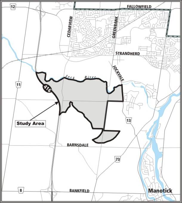
DOCUMENT 2
LAND USE PLAN
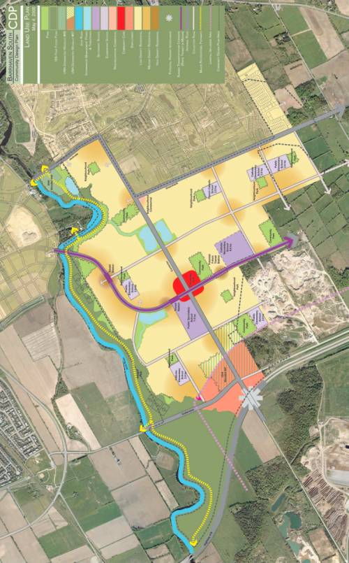
DOCUMENT 3
DEMONSTRATION PLAN
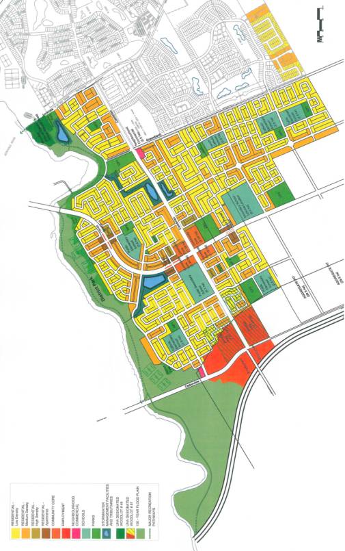
DOCUMENT 4
GREENSPACE PLAN
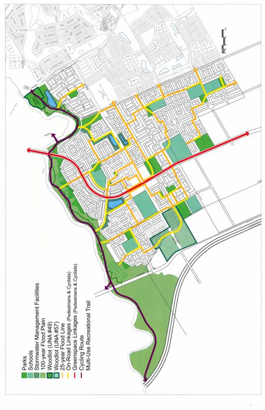
DOCUMENT 5
OFFICIAL PLAN AMENDMENT XX
INDEX
Page
THE STATEMENT OF COMPONENTS
PART A –
THE PREAMBLE
1.0 Purpose
2.0
Location
3.0
Basis
PART B – THE AMENDMENT
1.0
Introduction
2.0
Details
3.0
Implementation
THE STATEMENT OF
COMPONENTS
PART A – THE PREAMBLE, introduces the actual
Amendment but does not constitute part of Amendment No. XX to the
Official Plan (2003) of the City of Ottawa.
PART B – THE AMENDMENT, consisting of text and
schedules, constitutes the actual Amendment No. XX to the Official Plan
(2003) of the City of Ottawa.
PART A – THE PREAMBLE
1.0
Purpose
The purpose of Amendment No. XX is to
make revisions to six schedules within the Official Plan (2003) of the City of
Ottawa, regarding changes of land use and rationalizing of the urban boundary
on Schedules A and B; cycling on Schedule C; transit on Schedule D; and roads
on Schedules E and G.
2.0
Location
The subject lands are located within the
Barrhaven South area between the Jock River to the north, the urban boundary to
the south, Highway 416 to the west, and Jockvale Road and existing Greenbank
Road to the east. The study area is
approximately 500 hectares in size, and largely designated as “Developing
Community”. Less than 20 per cent of
the lands are designated either “Town Centre” or “Major Open Space”.
3.0
Basis
The Barrhaven South Community Design Plan
completed in May 2006 will guide development of this area as a compact,
liveable and transit-supportive community.
The Amendment proposes that the schedules
identified above, be revised to implement the recommendations stemming from the
Barrhaven South Community Design Plan and the Barrhaven South Transportation
Master Plan. The Amendment also
implements recommendations from two Transportation Environmental Assessments, (Southwest
Rapid Transit Extension and the Greenbank Road widening) and the Urban Natural
Areas Environmental Evaluation Study (UNAEES) for lands located within and in
proximity to the study area.
The Amendment proposes a
rationalized urban boundary to promote an improved urban development pattern
that reduces the creation of many part lots and blocks, and accommodates the
creation of a modified grid pattern of streets. This is not an expansion of the urban boundary; it is a
rationalization on the Land Use Plan as recommended through the CDP study
process to follow a rectilinear boundary on a more or less “no net-gain” of
urban land basis.
The Amendment requires that a subwatershed
study and master servicing study must be completed, approved by City Council,
the Conservation Authority and other external agencies, as may be
required. In addition, policies are
proposed to prohibit the approval of urban development in proximity to a Sand
and Gravel Resource Area until the objectives of the Official Plan regarding
mineral resources are satisfied, and an alternate land use is approved on the
lands designated “Sand and Gravel Resource Area” immediately west of the urban
boundary.
The specific changes to the schedules are as
follows:
Schedule A - Changing
certain lands from “Urban Area” to “General Rural Area” and from "Sand and
Gravel Resource Area" to "Urban Area"; from "Urban
Area" to “Agricultural Resource Area” and from "Agricultural Resource
Area" to "Urban Area", to implement the recommendations of the
CDP which seek to rationalize the urban boundary on a more or less, "no
net-gain" basis of urban land.
Schedule B - Changing
certain lands from “"General Urban Area (Developing Community)” and
"Mixed Use Centre (Town Centre)” to “General Urban Area” and "Major
Open Space" to reflect the results of the CDP; rationalizing the boundary
to reflect the land use changes made to Schedule A above; and from "Major
Open Space” and "General Urban Area (Developing Community)" to “Urban
Natural Features” for UNA Sites #49 and #57 to reflect the recommendations of
the UNAEES.
Schedule C - Shifting
“On-Road Cycling Routes” to match the future alignment of Greenbank Road, from
the Jock River to the urban boundary within Barrhaven South.
Schedule D - Revising
“Future Rapid Transit Corridors” within Barrhaven South to “Alignment to be
Defined” along the Southwest Transit Corridor of new Greenbank Road and
removing it from its current location along Jockvale Road.
Schedule E - Adding
“Arterial, Conceptual (Alignment Undefined)” for new Greenbank Road; “Arterial
Existing” for existing Greenbank Road from Cambrian Road to where it is
illustrated as “Arterial Existing”; “Arterial Proposed” for Cambrian Road
between Cedarview Road and Highway 416; and removing “Arterial, Conceptual
(Alignment Undefined)” within Barrhaven South.
Schedule G - Removing
“Collector Existing” for Cambrian Road between Highway 416 and Moodie Drive,
and adding “Arterial, Conceptual (Alignment Undefined)” for same.
PART B – THE AMENDMENT
1.0
Introduction
All of this part of this document entitled Part
B – THE AMENDMENT, consisting of the following changes and text, constitutes
Amendment No. XX to the Official Plan (2003) of the City of Ottawa.
2.0 Details
The following changes are hereby made to the
Official Plan (2003) of the City of Ottawa:
(1)
Schedule
A of the Official Plan is amended to reflect Schedule 1 of this Amendment
(2)
Schedule
B of the Official Plan is amended to reflect Schedule 2 of this Amendment
(3)
Schedule
C of the Official Plan is amended to reflect Schedule 3 of this Amendment
(4)
Schedule
D of the Official Plan is amended to reflect Schedule 4 of this Amendment
(5)
Schedule
E of the Official Plan is amended to reflect Schedule 5 of this Amendment
(6)
Schedule
G of the Official Plan is amended to reflect Schedule 6 of this Amendment
Insert the following policy in Section 3.6.1
General Urban Area, after “9”:
“10.
City Council has approved a Community Design Plan for the Barrhaven
South Community to guide future development.
Development may proceed in keeping with the Community Design Plan and
policies elsewhere in this Plan, subject to the following policies:
a.) The City will not approve any development
applications for lands located within the Barrhaven South Community Design Plan
study area, until such time that the Subwatershed Study for the Jock River
Reach 1, the Master Servicing Study for the Barrhaven South Community, and a
Conceptual Fish Compensation Plan agreement have been approved by Council, the
Conservation Authority, and other agencies in accordance with applicable
legislation. An exception may be made
for lands located in the southeast sector of the land use plan, where water,
sanitary and storm drainage are accommodated in the approved servicing plan for
the existing Stonebridge community.
b) In
order to achieve the intent of the objectives of Section 3.7.4 Mineral
Resources, the City will not approve any subdivision, zoning (potential
exception could be a holding zone) or site plan control application for lands
within the Barrhaven South Community Design Plan study area that are located
within 300 metres of the Sand and Gravel Resource Area to the west of the
community in the rural area, until the conditions set for these lands in the
community design plan have been satisfied.
The community design plan presumes that the existing pit will have
exhausted its aggregate resources prior the development of the adjacent
lands. The Community Design Plan
indicates that these lands may be developed once the extraction of the mineral
aggregate ceases, or a study is completed to the satisfaction of the City,
which demonstrates that proposed development is compatible with the aggregate
operations. To demonstrate that the
mineral aggregate resource is depleted, an Official Plan Amendment shall be
required for an alternate land use on the Sand and Gravel Resource Area.
3.0 Implementation
The Amendment shall be implemented by the
powers conferred upon the City of Ottawa by the Planning Act, Municipal Act,
and any other statutes that may apply.
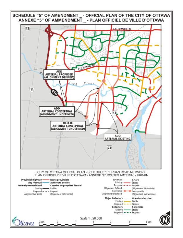
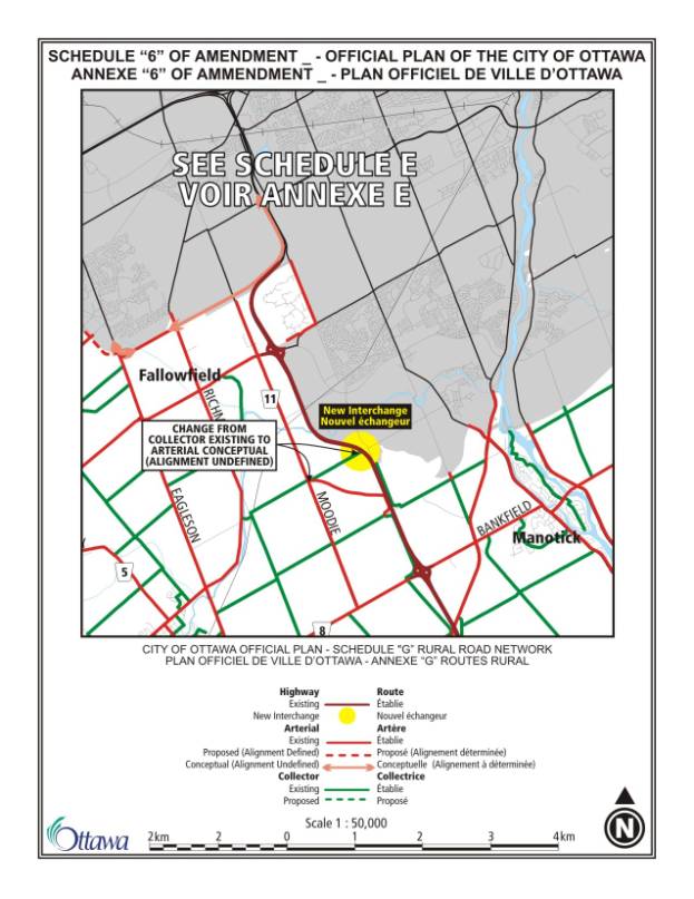
DOCUMENT 6
CONSULTATION
DETAILS
NOTIFICATION AND
CONSULTATION PROCESS
Notification and public consultation were undertaken as follows:
Four public open house meetings were carried out at key milestones during the study; one of the open houses also included a workshop venue for those residents who wished to become more involved and to provide detailed input.
Enhanced notification and public participation
was carried out and included:
- A
letter mailed to all abutting landowners within 120 m of the study area as
well as various community and environmental organizations noting the
commencement of the study
- Advertisements
posted in the “Nepean This Week”, the Citizen and Le Droit for all four
public meetings
- A
notification letter mailed to all participants as compiled through the
planning process for each of the four public meetings (which for the last
public open house amounted to approximately 200 people receiving
notification by mail)
- Attendance
and participation at the Ward Councillor’s Spring and Fall Open House
venues, highlighting key planning and transportation projects within
Barrhaven
Open House #1 – April 14, 2005
The purpose of the open house was to introduce the CDP process, and the parallel Class Environmental Assessments for roadways and infrastructure within the CDP study area. The evening consisted of a walk-through open house display, which highlighted the project process and Existing Conditions documentation. There was a formal presentation that gave an overview of the CDP planning process, study area location, additional ongoing studies in the area, and the existing conditions documentation. City staff and project team consultants were on-hand to answer questions from the public. Seven written comments were submitted.
Open House #2 – July 20, 2005
This open house provided the public with the opportunity to review preliminary land use concept plans and receive further detailed information on the ongoing Class Environmental Assessments for roadways and infrastructure within the CDP Study Area and the Jock River Reach One Subwatershed Study. A formal presentation was given highlighting the existing conditions in more detail, and an overview of the three concept plans. Following the presentation, a facilitated workshop was held, in which members of the public worked in small groups to provide input on the concept plans. Participants were asked to review the plans and report back to the larger group on which elements of the plans they liked, and those elements they would change. While written comments were not submitted per se, feedback was captured in an ‘as-heard’ record. These are summarized as follows:
Comments:
Network / Public Transit and Roads:
· Generally preferred concept A, with stronger / clarified transit link to Town Centre
· Liked concepts A and B for transit connection to Stonebridge, and Cedarview Road realigned with angle toward centre of the new community
· Liked Transit focus on serving higher density neighbourhoods of greater community (i.e. near new Greenbank Road bridge)
· Liked central transit corridor to serve eventual community development beyond current boundary
· Liked the open, porous neighbourhoods to give options in and out of the community
· Cedarview Road extension is essential to avoid traffic congestion if no interchange with Highway 416 is provided
· Maintain Cedarview as a western arterial
· Integrate roads with Stonebridge
· Concerned with the community transit connection to light rail in the town centre
· Prefer to not have an interchange at Highway 416 because of its location on a curve
Response: The final land use plan incorporated most
of the comments above, with a centralized rapid transit corridor that can be
extended to the south, should the urban boundary be extended in this location
in the future. The local transit
feeding through Stonebridge will feed into the central rapid transit
corridor. After many iterations of the
land use plan, the best alternative was chosen for Cedarview Road, which was to
leave it in its current location. This
was based on the impact its relocation would have on the existing woodlot, and
the undesirable block pattern of development that would result. Cedarview Road will remain an arterial road,
and future EAs to the north of the Jock River, will determine any widening
requirements. The road network is based
on a modified grid network to provide a porous, open community. An interchange at Highway 416 and Cambrian
Road is not a requirement for the build-out of this community. However, a flyover can be provided should it
be determined by the City that one is warranted in the future. The South Nepean Town Centre CDP has
indicated how the connections of the bus rapid transitway from the Barrhaven
South area will be addressed with the North-South LRT.
Public Spaces / Schools:
· Preferred plan that shows a concentration of sportsfields all in one area of the district park
· Preferred the district park to locate in the western sector of the plan, away from transit, residential density and congestion of core, and to rely on car access from Cedarview Road
· Preferred the plan where the district park shows sportsfields being split in two locations
· Sportsfields should be located outside of the floodplain, with maximum distance between fields and the river
· Liked the network of ‘green / blue’ links
· Move parks away from transit corridor and main streets
· Maintain the greenspace south of Half Moon Bay
· Need to link schools and parks and open spaces
· The plans show that the distribution of parks and open spaces achieves the 400 m minimum distance
· Keep Jock River as a linear recreational area, in a natural state
· Separate parks from public transit
· High schools should be located adjacent to large parks
· Ensure sufficient space for traffic in front of schools, and provide multiple access points to schools, by locating them at corners
Response: The
design of the district park will incorporate sportsfields between the 25 and
100 year floodline. Detailed design
work during the planning stages of the park will determine the best location. Public consultation for the district park
design will occur at that time. The
greenspace plan included in the CDP shows the linkages to schools, parks and
open spaces, and how they are accommodated in the ‘green / blue’ system. All residential areas within the CDP are
located within 400 m of a greenspace (school, park, open space). A trail along the south side of the Jock
River will be setback beyond the river’s bank in accordance with approvals from
the RVCA; a natural river’s edge will be maintained. The east side of the district park is located near the rapid
transit corridor along Greenbank Road, as is one community park. These parks will include many facilities,
and it is desirable to provide public transit in proximity to these sports
facilities. Current plans incorporate a
green link all along the south side of Half Moon Bay; the demonstration plan
also shows how a community park can locate in this area. Schools and neighbourhood parks may
co-locate.
Woodlots:
· Commit to protect and / or incorporate all woodlots, and respect UNA findings
Response: The
City is investigating several options with the developers with the intent to
acquire Cambrian Woods UNA #57 in City ownership. Other smaller woodlots in the study area were not included in the
UNAEES; however, all woodlots and hedgerows were incorporated at the time of
developing the demonstration plan and land use plan. Development applications require the submission of a tree
preservation plan to indicate tree species, size and condition and which trees
can be saved.
Tributaries / SWM Ponds:
· Ensure that stormwater management facilities can be utilized by pedestrians
· Longer meandering tributaries are preferred
· Save at least one or two of the drains for fish habitat
· SWM ponds are too small to provide sufficient retention for proper treatment
Response: Pathways
and single-loaded roads will be located along side tributaries and SWM
ponds. Tributaries and ponds will
become ‘natural’ over time, and pedestrians and cyclists will see the
recreational asset they offer to the community. The Master Servicing Study will determine the required width and
design of all ‘meander’ belts. The SWM
ponds are shown conceptually on the plans, and the Master Servicing Study will
determine the final size required to treat the stormwater to the City’s
satisfaction.
Residential / Commercial Uses:
· Like central area with high density
· Mixed use node (live/work) on Greenbank “Main Street” is good idea
· Pedestrian oriented commercial street is preferable to auto-oriented centre
Response: Higher
density uses will be located along Greenbank Road, and within or in proximity
to the community core. The intent is to
provide a pedestrian friendly commercial hub for the community.
Open House #3 – January 26, 2006
This open house provided the public with an opportunity to review, discuss and submit comments on the recommended draft land use plan, the conceptual stormwater management solution, the conceptual transportation roadway network, the natural environment system plan and the conceptual water and sanitary servicing plan. The evening consisted of a walk-through open house display with city staff and project team consultants on-hand to answer questions from the public. A formal presentation gave an overview of the CDP planning process to-date and outlined the evolution of the plan, including summaries of the issues that were addressed and the options that were assessed. The recommended draft land use plan was described and presented for consideration.
Comment:
A free public parking lot should be provided next to the relocated Greenbank Road bridge over the Jock River. There is a parking area now that is used by people who fish or launch canoes and kayaks.
Response: Access to the Jock River at Half Moon Bay was one of the specific requirements for the land use and demonstration plans for this new community. The City is working hard to maintain a minimum 50 metre wide green strip all along the south side of the Jock River, and to ensure that most roads that lead to the park area are only developed with houses on one side. The side that faces the river is meant to be open and accessible for all. While a specific parking lot on the south side of Half Moon Bay is not planned, cars will be allowed to park on the local road that abuts it, and larger parking opportunities about 30 m or so up stream from the current Greenbank Road bridge are being investigated as part of the pre-planning exercise. Both the north and south sides of the Jock River at this location will become a district park with ample provision of organized recreation and passive opportunities alike. Final plans will need to be done in consultation with the public and the local conservation authority, however at this early stage, confirmation on what can and cannot be developed is under review. Items such as a canoe launch, trails, look-outs, and even sports fields are all becoming "approvable", and certain activities - such as parking lots - are being advised to remain outside of the river's flood line.
Comment: Neither plan includes an access/exit (Cloverleaf) at the junction of Cambrian and Highway 416, which represents a significant shortcoming. When exiting Highway 416 at Barnsdale, the driver is directed to Prince of Wales Drive, where there is a major traffic jam most of the time. As such, a major cloverleaf must be built at Cambrian and Highway 416 that ties in with a four lane Greenbank Road extension to permit this South Community to have a major exit route in case of a National Disaster that required Emergency Evacuation. Otherwise future residents will be trapped just as all the people who live up in the Steeplechase/Mattawa Cres area of Kanata. This type of Emergency Evacuation planning must be included. The tax payers do not have the funds to go back and fix something that was missed in the original planning stage. Look what happened in New Orleans when they tried to evacuate a City!
Response: The planning and placement of
interchanges onto Highway 416 is under the jurisdiction of the Province of
Ontario. While initial area
transportation studies have identified some potential benefits of additional
access to Highway 416 for the arterial road network, no additional access
should be assumed. One of the
recommendations of the CDP is for a joint environmental assessment, of the
Cambrian Road crossing of Highway 416, with the Ministry of Transportation, to
determine the configuration of Cambrian Road and if additional access to
Highway 416 is appropriate at this location. Of note, the current Official
Plan continues to protect for the possibility of an interchange.
Open House #4 – March 29, 2006
The fourth and final open house provided the public the opportunity to review, discuss and comment on the recommended draft land use plan, the draft demonstration plan, an overview of the draft community design guidelines, the preferred stormwater management solution as well as the proposed water and sanitary servicing plan, and the proposed transportation plan for the road network. The format was similar to the other open houses, with walk-through displays where City staff and project team consultants were on-hand to answer questions and explore ideas and considerations with members of the public. A formal presentation was made providing an overview of the entire project and summarizing the details of the land use plan, the demonstration plan and the community design guidelines.
PUBLIC COMMENTS
SUMMARY OF PUBLIC INPUT
High-level comments were received
at the start of the study process, and as it evolved, more detailed comments were
provided. Most comments were oral and
were addressed directly at the public meeting.
Very few comments were received after the meetings or during and post
the review period of the Draft Community Design Plan. Many of the comments made at the public meeting related to
location of schools, the adequate provision of apartments, the road network and
location of stormwater ponds. Comments received on these issues are
outlined below along with an indication of how they were addressed.
Comment: The traffic demonstration board does not reflect what the residents’ experience is especially east of Greenbank Road to Highway 16 (Prince of Wales Drive). Perhaps this is partly due to the significant increase. This has been evident in Hearts Desire and Bren-Maur Road. This community does not want or need public transit (we have none now). Changing to urban transit will not change this except to charge more taxes.
Response: Changes to the road network north of the
Jock River are planned to address this issue.
Comment: Two participants requested a copy of the Jock River Environmental Survey.
Response: Both individuals will be circulated with
a copy of the subwatershed study report that will contain the flora and fauna
species list.
Comment: Interest was expressed for this community to provide apartment buildings (rental) units.
Response: A minimum of 10 per cent of the total
number of dwelling units, or approximately 680 apartment units, will be
provided in the Barrhaven South community.
The City however, cannot control tenure.
Comment: Where is the plan for the hospital? Over 100,000 people are planned (for this area) and the nearest hospital is 20 minutes away – the Queensway Carleton. Someone needs to talk to the province.
Response: The director of Planning and Facility
Redevelopment of the Queensway Carleton Hospital (QCH) attended a Technical
Advisory Committee meeting in the spring of 2005. Based on the projected number
of units and population for Barrhaven South, he indicated that the QCH would
continue to plan for, and /or accommodate the additional residents of this
community.
Comment: Public transportation is not a bad thing – in fact, it is good and in keeping with preservation and protection of the environment and in promotion of the Kyoto Accord, but does it warrant turning Hearts Desire into an urban community? Concerned how this will affect property taxes.
Response: The Barrhaven South CDP did not take this issue into consideration, as it is located outside the boundary of the study area.
COUNCILLOR’S COMMENTS
The Ward Councillor is aware of the study
Comment
- Major Observation
The concept plans continue to be designed first, to maximize the area for residential housing construction, and as an after thought tries to fit-in some of the natural features within the plan. We are still dealing with a draft CDP, it is not too late to seriously look at the existing environment and adjust the layout accordingly. A “Tree Planting and Preservation Plan” obtained only at the Plan of Subdivision and Site Plan Approval Stages is too late in the process, since the majority of the natural features have already been removed by the proponent(s) and/or the grade has been changed significantly.
OFGAC Recommendation:
1. That the City, the developers and their consultants use an overlay of existing features when planning for roads, parks, pathways, commercial, institutional and residential development, in order to integrate mature woodlots and hedgerows within the CDP landscape.
2. That a “Tree Planting and Preservation Plan” is required earlier in the planning process to allow for the integration of the majority of the mature vegetation and natural features, prior to any grading changes or clearing permits are approved.
Response: The
existing topographic mapping was used at the very initial stages of developing
both the land use plan and the demonstration plan. Every attempt was made to place hedgerows and woodlots either in,
or adjacent to, larger blocks of land typically associated with parks and
schools, or running alongside major streets, in order to establish ‘potential
locations’ for the preservation of these natural features. The overlay has been used on all subsequent
changes to the demonstration plan.
The “Tree Planting and
Preservation Plan” is required at the time of development approval,
concurrently with all other required documentation, including the grading plan;
the grading plan and tree preservation plan must ‘work’ hand-in-hand, to
provide the detail necessary to satisfy both the City’s servicing requirements,
and the needs of preserving the natural environment.
The CDP will include a guideline that would identify
potential locations to support the preservation of natural feature by use of an
overlay on existing topographic mapping, and the site’s servicing and drainage
plan to be formulated concurrently with this objective in mind.
Comment - Potential Highway Interchange
OFGAC is not in favour of an on/off ramp at the Cambrian and Cedarview Road location to gain access to the Memorial Highway 416, because of the considerable damage that it would cause to the significant woodlot #57. Consider the existing access loops south of the CDP at Bankfield/Brophy Roads and, north at Fallowfield Road to be sufficient. There are no funds budgeted for such an elaborate project in the near future. Should the situation change in the longer-term, consider re-utilizing the road network at Barnsdale Road and Highway 416. This would minimize cutting into the existing landscape and reduce the cost of construction.
OFGAC Recommendation: Re-utilize the road network at Barnsdale and the 416 to create a highway interchange should traffic studies indicate the need for additional access to the Memorial highway.
Response: Both
the City’s Transportation Master Plan and the Official Plan (2003) have
identified Cambrian Road and Highway 416 as a “New Interchange”. In addition, an Ontario Municipal Board
decision includes the requirement for the Ministry of Transportation to pay for
an overpass at the Cambrian Road location.
Until an Environmental Assessment is carried out to establish the need
for such road improvements, or an Official Plan amendment is made to remove it
from the schedule, it must be reflected in the Community Design Plan.
Comment - Current drains
The proposal for three storm water management ponds (Option 3 of the Jock River Reach 1 Sub watershed Study) makes use of some existing drains and decommissions others. OFGAC is concerned that the Cambrian Woodlot will be negatively impacted by the changes. The Hydrologic regime of wetlands, currently under review by the City’s Technical Team, J.D. Paterson and Niblett, is due at the end of April.
OFGAC Recommendation: Emphasis on the water requirements of the Cambrian Woodlot for future preservation needs to take precedence over the drainage and grading for other land uses.
Response: Maintenance
of the hydrologic regime of the woodland which supports swamp forest is a
requirement of the subwatershed study.
It will need to be demonstrated that the development and drainage scheme
will have no negative impact on the feature and function of the woodland.
Comment - Employment area
This area forms part of the Cambrian Woodlot UNA #57.
OFGAC Recommendation: The current landowners (Transport Canada) should be made aware that they are the stewards of this property and its natural features.
Response: The
Ministry of Transportation is a member of the Technical Advisory Committee and
is aware of its ownership.
Comment - Woodlots UNA #57
We congratulate the City and its Team on retaining the Cambrian Road alignment that already cuts through this woodlot. We note that the ownership has not been secured and would like to see the City use its Acquisition Fund to acquire Woodlot UNA #57 in its entirety for the purposes of preservation.
The natural features of a forest and its chances of survival depend in large part on the sustainability and natural function of its wooded edge. The vegetation, trees and shrubs that form the edge of the woodlot, are the front line in the forest’s protection against wind exposure and other elements. This belt of trees, often consisting of younger trees, is acclimatized to fight the elements. The removal of the wooded edge exposes the next set of trees to unfamiliar conditions, which cannot acclimatize themselves overnight to fight the elements, and often this begins the destruction of this belt of trees and commences the process of the forest’s deterioration. The removal of a substantial part of the woods edge will jeopardize the entire forest’s survival. The retention of the belt of trees that form the wooded edge and meeting existing grades, assist in the future survival of the forest. In addition, there is a significant reduction in quality of forest thru fragmentation. The Cambrian Woodlot UNA #57 is the largest of its kind in the area and will be providing many benefits to a population housed in 11,000 residential units over the next two decades and well into the future.
OFGAC Recommendation: That the City of Ottawa use its Acquisition Fund to acquire Woodlot UNA #57 in its entirety for the purposes of preservation for future generations.
Response: A
further assessment of the Cambrian Road Woods was undertaken as part of the
Jock River Reach 1 Subwatershed study.
A detailed, vegetation community description and mapping exercise was
undertaken for the woodland by Niblett Environmental. Based on vegetation community type, significance, and function as
interior forest habitat, a core woods was delineated. This core woods represents approximately 24 hectares. A peer review was undertaken of this
assessment and City staff is in agreement with the area of woodland to be
protected should the City be able to acquire it. Currently, the City and the landowner are in discussions on ways
to acquire this property. There is no
funding available through the City’s acquisition budget for this purchase.
Comment - Southeast part of Woodlot #57
This forest cover, northeast of the sand pit, is represented in the March 29th layout as a Community Park. This implies a further destruction of the Cambrian Woodlot. The intent should be to incorporate as much of the woodlot into a park for passive recreation, given that the demographics show that the population is aging and in need of a more diverse form of recreation than active sports (i.e. soccer fields etc).
OFGAC Recommendation: In lieu of completely destroying this part of the Cambrian woodlot, maintain its forest cover with a tree grove and pathway for passive recreation.
Response: Public
consultation is undertaken for development of City parks, and it is appropriate
that these comments be made at that time.
Requirements to-date indicate that one full-sized sportsfield is
required on each of the community parks; notwithstanding that, attempts are
usually made to accommodate natural features provided they can be incorporated
into the park design without negating the park’s purpose. This area is outside the core woods that are
recommended for protection.
Comment - Proximity of Residential Construction to UNA
#57
Medium-high density residential units are shown in too close proximity to UNA #57, on the north and east sides of the woodlot. This has the potential to severely impact the preservation of the Cambrian woodlot.
OFGAC Recommendation: Create a larger buffer than currently used
in recent residential developments (i.e. Chapman Mills – Strandherd Woodlot)
and road creation (i.e. Riverside South - north of Earl Armstrong), between any
development and UNA #57 to adequately preserve the forest cover and ensure its
future growth. The
homes should be built with the backyards facing UNA #57. This would help to further protect this
woodlot. We also recommend that the
parking lot or any other structure near the woodlot consist of permeable
material.
Response: Design guidelines for development adjacent to the woodlot will be provided in the Community Design Plan. Urban design elements that can minimize impacts to the woodland such as the examples provided by OFGAC will be considered.
Comment - Linkages - Blue & Green
Everyone in the community can enjoy the open spaces in passive and active recreation. Design the linkages between the different sized parks for pedestrians and cyclists to enjoy, while providing wildlife circulation.
OFGAC Recommendation: Create linkages by incorporating the natural
spaces along the Jock River and its tributaries (blue) with the existing
natural features and vegetation (green) throughout the CDP.
Response: The greenspace plan indicates the intent to provide for such linkages.
Comment - Water Run off
More trees equate to “greater pollutant capture” and “greater carbon storage”, in addition to producing “less runoff”. How much of the rainfall that falls on the site will run off and how quickly? Sites with less tree cover will have lower volume. The City should assess the extra cost of runoff with the removal of trees. What will be the volume of water to be managed if the trees were removed from the site? What will be the additional cost of managing the site’s storm water without trees? The removal of “x” number of trees will cause an increase in erosion and additional water runoff, which increases the cost to manage the water (i.e. re-route it, contain it, etc).
OFGAC Recommendation: Do a complete analysis that answers the questions noted above. And, provide a cost comparison of the proposed facility construction for the storm water protection (i.e. ponds, drains, etc.), with the land costs.
Response: The subwatershed study and the master drainage plan have undertaken the required analysis to determine the best methods to drain the site, while taking into consideration the needs of other agencies, including the degradation policies of the Ministry of Environment on the Jock River, the quantity of allowable run-off as determined by the Rideau Valley Conservation Authority, and the impact on fish habitat as per the policies of the Department of Fisheries and Oceans.
Comment - East side of Greenbank residential development
This area of proposed residential development encroaches outside the urban boundary and includes a large woodlot.
OFGAC Recommendation: In lieu of proposing to cut into the woodlot, utilize the open field space instead for the extension of the residential development. Provide the full woodlot description and environmental evaluation for consideration.
Response: This woodland was not identified in the Urban Natural Areas Environmental Evaluation Study. Full protection of the woodland would require acquisition by the City that would be difficult to justify based on the protection priorities arising from the upcoming Urban Natural Features Strategy. This strategy will identify new priority woodlands to protect in the urban area. The protection priority in the Community Design Plan area is Cambrian Road Woods.
Comment - The Landfill Site Zone of Influence
Results of an environmental study to determine the appropriate land uses within the proximity of the Trail Solid Waste Facility, west of Highway 416, is unknown to date. The Official Plan indicates that development proposals within 500 metres of an active waste disposal site must demonstrate that there will be no impacts from the proposed use on continuing landfill operations. Destruction of the surrounding forest cover is unnecessary at this stage and should be discouraged.
OFGAC Recommendation: Retain the natural features, namely the tree cover, surrounding this area until it is officially determined what the appropriate land uses within the proximity of the Trail Solid Waste Facility will be.
Response: An odour and dust assessment for the Trail Waste Facility was undertaken in the fall of 2005, with a report completed in February of 2006. Recommendations included that the City adhere to the 500 metre setback distance specified in the Ministry of Environment’s D-4 guideline for landfills. As such, no sensitive land uses are proposed within 500 metres of the landfill. An employment area land use category is located between the woodlot and the landfill; based on a maximum 35 per cent lot coverage requirement for buildings, the potential for tree retention is higher.
Comment - Urban Boundary
In 2008 the urban boundary for the City of Ottawa is scheduled for review. Discontent among the developers on the current urban boundary, as outlined and approved in the Official Plan, has resulted in an appeal. An appeal is now underway for 1 km surrounding the current urban boundary. The situation creates uncertainty and threatens the protection of the surrounding natural features and major forest cover of the rural areas in close proximity to the urban areas.
OFGAC Recommendation: Retain the natural features, namely the forest cover, surrounding the urban boundary until the 2008 official municipal review of the current urban boundary.
Response: Rationalizing the urban boundary that has taken place as part of this CDP planning exercise does not impact the natural features and major forest cover abutting the boundary. UNA #57 has been identified for protection despite a portion of it falling ‘out’ of the urban boundary as a result of this planning exercise. To the east of Greenbank Road, where the boundary again is rationalized by replacing a portion of “Developing Community” with “Agricultural Resource Area”, no woodlot has been included.
Other OFGAC Recommendations:
Comment: Provide stricter guidelines for new bridge construction that addresses the issues of erosion and soil sediments and their negative impact to the river.
Response: The details related to potential impacts of new bridge construction and identification of mitigation measures would be included in the Southwest Rapid Transit Corridor Extension and Greenbank Road Widening Environmental Assessment.
Comment: Mitigation measures for the grading alterations around, and in the proximity of, the woodlots and mature hedgerows include the compilation of very accurate elevation data. Compile existing and proposed elevation data to record the implications to the erosion measurements.
Response: An Environmental Impact Statement (EIS) will need to be prepared as part of the Plan of Subdivision process for any development within 30 metres of the two woodlands to be protected. Mitigation measures associated with development impacts on the adjacent woodland would be detailed in the EIS that is subject to City approval.
Comment: The Hydrologic Soil Analysis to indicate the soil composition, infiltration and infiltration rate of the existing landscape, particularly around the woodlots and mature hedgerows. Mitigation measures to address changes in the soil composition around the woodlots and mature hedgerows to be included as part of development agreements.
Response: An EIS
will need to be prepared as part of the Plan of Subdivision process for any
development within 30 metres of the two woodlands to be
protected. Mitigation measures associated with development impacts
on the adjacent woodland would be detailed in the EIS that is subject
to City approval. This would include mitigation measures to maintain the
hydrologic regime of the woodland. Further details will also be available
in the final subwatershed study.
Urban Design Guidelines:
Comment: OFGAC proposes the following to be included in the creation of the Urban Design Guidelines for the new Barrhaven South Community Development.
1.
Natural Spaces
Comment: Plan the community around the natural features of the site, instead of ignoring the existing vegetation (hedgerows, significant mature tree stands, woodlots, etc) in creating the CDP.
Response: Addressed in Guideline 6.2.3
Comment: Guiding principles for the development of Barrhaven South is to make the forest cover, woodlots, mature hedgerows and significant trees, a signature statement to the overall design concept of this community.
Response: Included in Guiding Principle 4.1.6 – Create an Integrated Green / Blue System
Comment: Create focal points within the landscape and enhance the streetscape design of the community by preserving existing mature hedgerows, majestic mature trees or clusters of significant tree stands. Define and create a sense of space filled with natural features, an amenity which is often sought after by new home-buyers.
Response: Addressed in Overall Community Guidelines 6.2.1, 6.2.3, 6.2.4, and 6.2.5. Additional landscaping and tree guidelines are provided in Parks & Greenspace, Linkages & Trails, Stormwater Ponds & Tributaries, Community Core, Residential Neighbourhoods, and Employment Areas.
Comment: Create a visual entry point by integrating existing natural features such as prominent mature trees.
Response: Addressed in Overall Community Guidelines (6.2.1-6.2.6). Specifically, 6.2.5 states the where possible prominent mature trees should be incorporated into gateway features.
Comment: Recognize the value of existing tree cover as they provide health benefits for all life, produce oxygen for us to breathe, provide wildlife habitat, combat global climate change, promote soil conservation, improve water quality, use of trees in dealing with runoff, increase property values, significantly enhance the streetscape, etc. Include the full range of values in the Park and Recreation Strategy for the Barrhaven South CDP.
Response: The general guidelines for overall community identity (guideline 6.2.5) make reference to incorporating prominent mature trees, any where in the development area. An additional guideline will be added to the parks & greenspace section to include a statement “on integrating good specimens of healthy trees into the park design, where possible”.
2.
Recreational Spaces
adjacent Woodlots
Comment: Provide a set back along the perimeter to active recreation plans adjacent wooded areas. Allow for a minimum of 5 metre setback to minimize disturbance to the root zone, plus five-meters for soft surface material, and a five meter buffer zone before any hard surfaces are installed to accommodate parking. Consider permeable surfaces for parking areas as opposed to paved hard surfaces such as asphalt.
Response: Woodlands & adjacent development guidelines are being added to section 6.0 of the CDP to minimize impacts on woodlands. Again, an Environmental Impact Statement would be required for adjacent development that will need to demonstrate no negative impact on feature and function of woodland.
3.
Greenspace and
Streetscapes
Comment: Increase greenspace in front of medium to high-density buildings and introduce set backs to allow for green front yards.
Response: Guideline 6.6.7 includes landscaping in the setback. Minimum set backs are encouraged to create a public street edge.
Comment: Introduce courtyards for medium to high-density buildings for trees, benches and mail kiosks.
Response: Consideration of courtyards will be at the time of site plan approval.
Comment: Incorporate neighbourhood parks as focal points with buildings facing the parks and parking behind the buildings. Example: Bois-Franc in Saint-Laurent, Montreal. This residential development is a good model of creating friendlier neighbourhoods with common greenspace areas and innovative use of land to increase permeable surfaces throughout the community.
Comment: Introduce underground parking with green rooftops as backyards for medium-density residential units (townhouses and carriage homes).
Response: Nothing in the CDP precludes this from happening.
Comment: Use berms and the planting of trees and shrubs as opposed to sound attenuation fences (when homes back onto major roads). If a fence is required, consider using black chain link fences, trees and shrubs, as shown with the Stonebridge residential units backing onto Jockvale Road.
Response: The CDP does not recommended sound attenuation fences, but black chain fencing does not attenuate for noise.
Comment: Face homes with a greenspace of trees and shrubs between the residential units and the major roads. This concept was used in Chapman Mills homes that face Woodroffe Avenue, on the northeast side of Strandherd Road, and again on the north side of Strandherd across from the retail area (Shoppers Drug Mart, Loeb etc.)
Response: This is contemplated in many areas of the
CDP, as illustrated on the demonstration plan.
4. Lighting
Comment: Introduce street lighting at the pedestrian level, especially in areas where walking is encouraged, such as commercial retail spaces. Discourage harsh and towering light standards in parking lots and encourage lighting at the pedestrian level.
Response: This will be dealt with the development review process in accordance with city lighting policy.
BACKGROUNDER:
A. OFGAC’s Submission of January 31, 2006.
The comments in OFGAC’s January submission were based on the chosen Concept C CDP of July 20, 2005, and modified to reflect the latest January 26, 2006 CDP.
B. February 8, 2006, CDP Plan
OFGAC has reviewed this latest plan, discussed it with City Staff and members of the South Barrhaven Sub-committee for OFGAC.
C. March 29, 2006, CDP Plan presented at The Open House #4
The Fourth Open House for the Barrhaven South Community Design Plan (CDP) was held on the 29th of March 2006 at the Walter Baker Sport Centre in Nepean. The purpose of this open house was to present the latest CDP for the public to review, discuss and comment on the recommended: Draft CDP, Natural environment and park space system, Storm water management solution, Water and sanitary servicing system, and Transportation plan for transit and the road network.
OFGAC attended this Open House and obtained clarification from consultants and city staff on various issues.
D. April 3, 2006 Meeting
The members of OFGAC’s South Barrhaven Sub-Committee met with Cheryl Brouillard (Planner) and Susan Murphy (Environmental Management), both from the Planning & Growth Management Department, to discuss concerns raised in OFGAC’s original submission and address how these issues relate to the March 29th CDP.
Up-date on OFGAC’s Comments of January 2006, presented to City
Staff.
The purpose of this up-date is to: 1. Confirm that the March 29th layout addressed some of the major points OFGAC had raised in its January 2006 submission; 2. Ascertain that these revisions remain as part of the final CDP.
Comment: a) Combine the transit way extension and Greenbank vehicular traffic on one bridge, as opposed to two separate ones, over the Jock River, to minimize the disturbance to the local environment.
Comment: b) Centralize the transitway extension to the 8000 residential units to encourage its use.
Comment: c) Use the current alignment of Cambrian Road as it already severs the Cambrian Woodlot.
Comment: d) Relocate the 416 access ramp at Barnsdale and Cedarview Roads. Re-use existing road network and re-configure existing loops saving taxpayers’ money and further destruction of forests in the area. Further study to examine the environmental impacts and alternate configurations will be conducted with MTO and the City of Ottawa.
Comment: e) Consider utilizing existing Cedarview and Greenbank for North-South routes, and Strandherd and Barnsdale as East-West routes, with some modifications and up-grades to serve the new community. This would reduce the need for building additional major roads and minimizing additional cutting of the existing landscape.
Response:
Transitway and transportation issues in comments (a) through (e) above
are dealt with through the Environmental Assessments, or are already reflected
in the CDP.
Comment: f) Drains and Stormwater Management Ponds to form part of the blue/green pedestrian pathways throughout the new community and link up to the Jock River pathway.
Comment: g) Alterations to the existing grades shall not interfere with the water requirements of the existing woodlots and UNA woodlots # 49 & 57.
Response:
These are subject to the Master Servicing and Subwatershed Studies that
will be coming forward to Planning and Environment Committee.
Comment: h) That the City of Ottawa’s Environmental Resources Area Acquisition Fund be used to purchase and protect what remains of the forest referred to UNA #57 in its entirety, to protect it for future generations.
Response: See
earlier comment.
Comment: i) Incorporate the southern and most eastern part of the UNA #57 into the proposed park, for the purposes of passive recreation and natural linkage to the Cambrian woodlot.
Response: See
earlier comment.
Comment: j) Create linkages between all of the different size parks for pedestrian, cyclists and wildlife circulation to incorporate the natural spaces along the Jock River and create better linkages (green) to the community’s greenspace, passive and active recreation.
Response: The
greenspace plan indicates on- and off-road linkages, multi-use recreational
trails and cycling routes.
Comment: k) District Park to be split between Cedarview and Greenbank Roads, reducing traffic congestion and pollution and, the need for large expanses of manicured cut grass, thus permitting areas along the Jock River to remain as meadows throughout the watershed.
Response:
Public consultation will be undertaken for the development of the
district park.
OFGAC is available to further elaborate on the recommendations set forth.
This review was prepared by the South Barrhaven Sub-Committee for OFGAC. At the April 2006 OFGAC Monthly Meeting, approval in principle was provided.
Accessibility
Advisory Committee
I make the following
comments on behalf of the Accessibility Advisory Committee. Your information did not reach me until May
01, so clearly I could not meet your deadline of April 21. My comments, however, are general in nature
and not such as likely to delay any approval process.
The City of Ottawa includes in its vision statement that it is to be inclusive and welcoming. One aspect of inclusiveness is that persons with physical disabilities should be able to access all city services and to take a full role in its activities. This means that they should be able to travel to all parts of the city, to enter all city owned and managed buildings, to have a variety of residences where they may live, and to be able to visit friends in their homes. In other words, to be able to live their lives just as the able-bodied do and take for granted.
We would expect that the transportation needs of the disabled will be quite well met in this new community. The program to introduce easy access buses is well advanced and proceeding to plan. More accessible taxicab licenses are being granted and we would expect the new light rail to include provisions for accessibility.
It is to be hoped that the new commercial and industrial developments will be designed for accessibility. To do otherwise makes no economic sense, as the provisions of the AODA will make this mandatory during the life of these buildings, and rework is much more expensive (by as much as a factor of ten) than meeting these requirements initially.
We have concerns about the residential sector. Ideally, there should be a significant number of dwellings that are fully accessible; where one with a disability may live in comfort. Most, if not all dwellings, should be visitable; that is, one should be able to visit an able-bodied friend in his/her home, have a meal and visit the bathroom. A third concept is that of universal design. A home should be constructed such that walls are easily replaced and, should a person have an accident or contact a disease that renders him/her disabled they should be able to readily modify the home to make it fully accessible, and without undue financial hardship.
A primary consideration on accessibility is minimum
grade separation. Unfortunately, this
cannot be achieved with some types of residences, stacked town houses being a
notable example. This type of housing
is neither accessible, nor visitable, and cannot readily be modified to
suit. Minimum grade separation is not
often a consideration with other types of housing, as even detached housing
often does not pay attention to this need.
In this respect apartment buildings are often better, although care must
be taken to ensure that some units are fully accessible to bedrooms and
bathrooms.
We trust that you will bring these concerns to the attention of developers, as the construction of this community proceeds.
Response: A design guideline will be added in Section 6.2 - Overall Community Identity which speaks generally to the need to consider and incorporate appropriate measures that promote accessibility in terms of the planning and design of linkages and the parks network, and the design and construction of commercial, industrial, institutional and residential buildings.
Cycling Advisory Committee
The review of the Barrhaven South CDP
revealed scant mention of facilitating bicycling.
·
Integration with the draft Ottawa Cycling Plan
·
Slow speed shared roadway alternatives to the arterials
·
Pathway alternatives to reach schools, parks, shopping, and transitway
stations
·
Secure opaque bicycle lockers for apartment residents
·
Bicycle parking at institutions and places of worship
·
Shower and locker facilities at places of employment
While cycling is certainly a popular
recreation, it is more than that. It is a transportation alternative for all
within and between communities in Ottawa.
Let's encourage cycling by making it a focus of the CDP, not an
afterthought.
Make it easy to walk or cycle around Barrhaven South by designing more
connections between its pieces via "Bicycle Boulevards" and pathways
rather than having a maze of little streets going nowhere. It is as if you imagine everyone to just
stay at home or go downtown! Facilitate walking and cycling to local facilities
without getting lost.
Response: The
modified grid system of roads, the multi-use recreational trails and pathways
all serve to provide a comprehensive network for the cyclist and
pedestrian. A guideline has been added
to “Overall Community Identity” that encourages cycling through the design of
neighbourhoods and buildings, by providing pathway alternatives to reach
schools, parks shopping and transitway stations, and by providing safe and
conveneitn storage for bicycles at places of employment, commercial areas,
institutions and places of worship.
DOCUMENT 7
CIVIC FACILITIES, PUBLIC UTILITIES AND
TECHNICAL AGENCIES
Fire
Ottawa
Fire Services is presently undertaking a detailed fire station location study
in the suburban area and growth areas of the city, including the rapid growth
area of Barrhaven. Once the study is
complete, which is anticipated to be in December 2006, Ottawa Fire Service will
be in a position to indicate where an additional station in the Barrhaven area
will be located. It is estimated that
an additional station will be required within the next 10 years in the
Barrhaven area on approximately a 0.8 ha corner lot, possibly next to a park or
other compatible location.
Police
Ottawa Police Services does not anticipate the
need for a major facility within the Barrhaven South area. However, Ottawa Police Service may require a
future Community Police Centre that is housed within a civic facility. Within the CDP, a Police Service Facility is
permitted on all land use categories, subject to built form requirements, and
could be accommodated within the community core area.
Paramedic
The Ottawa Paramedic Service is currently
located at the Nepean Fire Hall on Greenbank Road, and has made a request for a
site on the city-owned lands on Longfields Drive to re-locate this Paramedic
Post. This new site would serve all the
residents of South Nepean, including the Barrhaven South area, and, therefore,
a site within Barrhaven South is not required.
Within the CDP, a Paramedic Post is permitted on all land use
categories, subject to built form requirements, and could be accommodated
within the community core.
Library
The Ottawa Public Library is currently
undertaking a Facility Growth Planning Study regarding future library
facilities related to growth over the next twenty years. The Ottawa Public Library will be able to
identify library needs in these areas of the City once this study is
completed. Within the CDP, a library is
permitted on all land use categories, subject to built form requirements, and
could be accommodated within the community core.
Client Service Centre
The Client Services and Public Information
Branch of the Corporate Services Department does not foresee any additional
requirements within the Barrhaven South area.
Within the CDP, a client service centre is permitted on all land use
categories, subject to built form requirements, and could be accommodated
within the community core.
Hydro Ottawa
Thank you for the opportunity of commenting on the draft Community Design Plan for the Barrhaven South development area of Nepean. Hydro Ottawa is pleased to work with the City in an attempt to provide the necessary electrical infrastructure for the new development that is affordable, reliable, and which meets the Urban Design goals identified in the CDP for this area.
Comment: As background, in the past the major electrical utility infrastructure, in most parts of Ottawa, has been installed overhead along the main arterial and collector roads, to provide electrical supply to new residential and commercial development areas. Within residential subdivisions, the power lines were mandated, by a number of the various former municipalities, to be installed underground. In major commercial parks however, the local electrical servicing was provided by overhead plant, unless contributions were received from outside parties to fund the extra cost of underground infrastructure. These servicing standards continue to drive the current Hydro Ottawa system expansion planning. Our current electrical rate structure has been based on this standard of supply. Therefore, we do not have the ability to fund an “all underground” electrical system, without the provision of offsetting funding from outside parties.
Response: Funding solutions will be required for scenarios in which underground electrical is desired. Where funding cannot be worked out, the planning of overhead wiring will be undertaken in the comprehensive review of composite utility plans at the time of draft plan of subdivision, (e.g., utility trenches, tree planting and other right-of-way infrastructure needs).
Comment: From the proposed roads cross sections in 6.3 of the draft document, we are assuming that you are not anticipating any overhead pole lines being constructed along the arterial or collector roads. With the proposed vegetation it would simply not be technically possible for us to install a pole line. Thus, we infer that your goal is to have our electrical trunk lines installed underground along the major road allowances. We understand the desire to improve aesthetics and are very prepared to work with the City to achieve its goals, provided that Hydro Ottawa has a viable means of funding the higher cost of underground electrical infrastructure.
Response: The
City will work with Hydro Ottawa regarding the delivery and costing of
underground servicing.
Comment: Accommodations can be made for the installation of underground servicing, however such systems must be properly designed and installed. Key elements that must be addressed, in a forum that involves all stakeholders, are the location of utility duct lines within the road allowance, and the position of large manholes, pad-mounted transformers, and sectionalizing switches, either in the boulevard, or on easements on private property. All utilities that have plant installed within the road allowance will have their own requirements as far as clearances to other types of infrastructure. Therefore, the development of road cross sections, acceptable to all parties, will require considerable effort and co-operation. We very much want to participate in this process.
Response: The
City will encourage, wherever possible, the co-ordination of the needs of all
utility providers.
Comment: The Street Cross Section drawings in the CDP clearly are not of sufficient detail to show the various utility infrastructures either above or below ground. These cross section drawings do emphasize the desire for planting within the boulevard along almost all of the proposed roadways. We note that trees can interfere with underground structures and therefore these must be co-ordinated in the development of detailed road cross sections.
Response: The
City will encourage utility providers to consider innovative methods of
containing utility services on or within streetscape features (such as lamp
posts, transit shelters, or other structures) in consideration of the overall
aesthetics of the streetscape.
Comment: Attached is a conceptual drawing showing existing, and proposed Hydro Ottawa trunk feeders, in the South Nepean area. The drawing shows the existing extensive Hydro Ottawa overhead plant installed along Strandherd Road, Greenbank Road and Jockvale Road. It is planned to install lines along the extension of Longfields Drive, as well as on a future east west road identified as “Line B” on the drawing. We understand that Jockvale Road is to be closed between Greenbank Road and Bren Maur Road. The major overhead feeders existing on this section of roadway will have to be replaced with other facilities. Furthermore, we have plans to rebuild existing lines on Bren-Maur Road and Greenbank Road to increase supply capability, and to enhance system reliability. Our drawing also shows a trunk feeder along Chapman Mills Drive that Hydro Ottawa has committed to installing underground. We have agreed to this based on the information received on the LRT project, and the ultimate road cross section which effectively make overhead lines impossible.
Response: The infrastructure discussed above is located outside the
Barrhaven South study area.
Comment: Please note that Hydro Ottawa,
has a required minimum clearance of
5 meters from
overhead power lines to
buildings higher than a single storey.
This 5 meter clearance ensures the combined minimum clearance requirements specified in
the Ontario Building Code (and the Electrical Safety Code), and the Ontario OHSA for work to be performed around primary
conductors, can be respected at all times both
during construction, and for future building
maintenance. This may impact the
proposed High Rise and Mid-Rise development shown in the CDP. All buildings must comply with the
legislated clearance requirements.
Response: While the CDP includes design guidelines for building setbacks, the clearance requirements of the Ontario Building Code and Electrical Safety Code would take precedence in those instances where clearance is an issue.
Comment: Installation of utilities in rear yard lanes is proposed in the
CDP. Hydro Ottawa has many years of
experience in dealing with electrical lines installed in rear yards, either
within lanes or on dedicated easements.
Due to the much higher maintenance costs, problems with access, and
clearance issues we have no desire to increase the extent of these types of
installations. In recent ADS Road Cross
Section approval reviews between, City, developers and utilities, the option of
placing utilities in rear lanes was rejected.
Response: Guideline 6.3.31 simply encourages utilities within rear lanes; it does not require utilities to be within rear lanes. Should rear lane utility works be proposed for any development application, the City’s technical circulation ensures that all utility companies are provided ample time for input.
Comment: Hydro Ottawa is committed to working with the City to achieve its
aesthetic goals for the South Barrhaven.
However, to achieve an “all underground” design for this area of the
City, funding will be a critical issue to resolve.
Response: The establishment of a funding mechanism for burying
hydro lines on certain streets would need to be worked out following approval
of the CDP. Should an agreement not be
reached, any impact resulting from above-grade hydro wires will have to be
resolved through the review period of development applications.
Bell Canada
In recent years, Bell Canada has recognized the importance of becoming involved earlier in the municipal planning process and has undertaken a broad initiative to become engaged in this process. Early involvement also allows Bell to ensure its network is planned in an orderly and coordinated manner with other stakeholders. One of the key components of our broader initiative is to consult with municipalities to ensure that there is appropriate policy language in relevant planning documents, and to identify, if known, the locations of major future infrastructure requirements.
It is our understanding that the Community Design Plan dated April 10, 2006 is in ‘draft’ format and that the City of Ottawa is currently inviting comments from interested parties. Accordingly, Bell Canada thanks you for the opportunity to review the draft Barrhaven South Community Design Plan. We offer the following comments for your consideration:
Section 5.1.9 – Uses
Generally Permitted In All Land Use Categories
We suggest
that a new paragraph recognizing the location of utilities be added. The suggested wording would read as: “Public and private utilities shall be
permitted in all land use designations and shall be installed within public
road allowances or within appropriate easements, as well as on private
property.”
Response: This has been added in the
opening section of 5.1.
Part 6 – Community Design Guidelines
Section 6.2 – Overall
Community Identity
We suggest that the
following two Guidelines be added to subsection “Overall Community Identity”,
as we would intend for these policies to apply to the entire community:
6.2.4 “Encourage, wherever possible, utility
coordination and location within an initial common trench to avoid unnecessary
over digging and disruption of the municipal right-of-way.”
6.2.5 “The City should encourage utility providers to consider innovative methods of containing utility services on or within streetscape features such as lamp posts, transit shelters, etc.”
6.2.6 “Prior to approval of development, all
interested utilities and telecommunication providers are to confirm if services
can be provided to support the proposed development. Developers should consult with utility and telecommunication
providers in the early stages of development to determine appropriate locations
for large utility equipment or utility cluster sites.”
The rationale for the
wording of Guideline 6.2.6 is to anticipate the need for locating major
above-ground utilities (e.g. walk-in cabinets) or clusters of utilities that may
be needed to service this new neighbourhood.
This type of policy makes it clear to future developers that a major
utility installation may be required in the area and encourages a coordinated
approach among utility service providers to cluster utility installations,
where possible, in targeted locations.
Response: New guidelines 6.2.11, 12
and 13 have been added to address the comments in 6.2.4 and 5 above; further
consideration is being given to the need for a guideline to reference the
comment in 6.2.6 above; given that a co-ordinated approach is already
undertaken through the technical review process and the Underground Utilities
Co-ordinating Committee.
Section 6.3 – Streets
Guideline 6.3.8
We suggest that the following text be added to the end of this guideline: “The location of street trees will have to be coordinated with the location of utilities and infrastructure that share the right-of-way.”
Guideline 6.3.15
We suggest that the wording of this guideline
be altered to include consideration of the placement of underground
utilities. The amended guideline would
read as follows: “Street
lighting, signs and utilities (above and below ground) located in the boulevard
should be aligned with the tree plantings to establish coordinated streetscapes.”
Guideline 6.3.23
This guideline
specifies that right-of-way widths shall be between 16.5 and 18 metres for
local, double-loaded roads, and 14 metres for local single-loaded roads. Though the City of Ottawa has approved the
18 metre ROW width, the narrower ROWs contemplated by the plan have not yet
been adopted by the City. Nevertheless,
it would appear that reduced ROWs will become an accepted standard in the City
of Ottawa in the near future. In
anticipation of this change, Bell would like to highlight the importance of
including wording in Community Design Plans that directs utility providers to
coordinate efforts (see recommended guidelines 6.2.4 and 6.2.6 above). It has been Bell’s experience in other jurisdictions
that reduced ROW standards can present additional constraints to the efficient
provision of utility services. However,
these constraints can be effectively managed by including appropriate policy
wording to ensure coordination among utility providers.
Guideline 6.3.29
The guideline establishes
a preference to have services located in rear lanes. In principle, Bell does not have a problem with rear lane
servicing; however, ideally we prefer to have the option of servicing from the
primary street. As is customary with
all development projects, and particularly when services are to be placed in
rear lanes, Bell will need to evaluate each proposal on a case by case basis to
ensure that we can provide telecommunications service for the development. It is our understanding that the rear lanes
proposed for the development area will be publicly owned. When working in areas with back lanes, Bell
prefers that the lanes are held in public ownership. If any of the rear lanes are to be privately owned, Bell will
require easements to place our equipment in the lanes. In summary, could you please confirm:
1) whether or not the
lanes will be publicly or privately owned; and
2) whether the option
to place services in the primary street right-of-way will remain available,
regardless of ownership?
Response: The proposed alternative street standards will have addressed the
requirements of the various utility providers.
Any guidelines contained within this CDP encourage appropriate placement
of utilities using those parameters as guidelines, always with the intent to
make site improvements when possible.
The Underground Utilities Co-ordinating Committee is still considered
one of the venues where initial comments can be sought for predevelopment
review, particularly for large projects.
Until the submission of development applications, it is not possible at
this time to indicate which lane products will have public ownership.
Ottawa Carleton
Catholic School Board
The Ottawa-Carleton Catholic School Board (OCCSB) is in receipt of the draft Barrhaven South Community Design Plan dated April 10, 2006. The Board has attended several meetings with regard to this design plan as well as forwarded several letters to both City staff and FoTenn Consultants. Our most recent communication was forwarded via email on April 4th, 2006. We have now prepared the following comments with regard to the most recent draft of the plan:
Number, Location, and Size of School Sites
The OCCSB requires two future elementary school sites (in addition to the elementary site designated within the Stonebridge subdivision) and one intermediate/secondary school site to serve the new Barrhaven South community.
The location and number of designated OCCSB school sites as outlined on page 22 is satisfactory. However, given the configuration and limited size of the adjacent Neighbourhood parks, the more limited facilities contained in these parks versus the Community parks, and the recent practice of the City to require the fencing between park/school properties, the OCCSB wishes to formally indicate to the City that all our elementary site sizes be increased from 2.45 ha (6.0 acres) 2.83 ha (7.0 acres).
Response: These
site have been increased in size as per the above noted comments.
Consideration to Move Secondary School Site
The Board does not support the current wording of the paragraph on Page 24 regarding the possible relocation of our secondary school site. We request that the paragraph be reworded as follows:
“The second secondary school site, which is located south of Cambrian, is identified by the Ottawa-Carleton Catholic School Board to meet their long-term needs. Should the urban boundary be extended prior to the School Board securing the site, the Ottawa-Carleton Catholic School Board will consider the relocation of the secondary site. Any relocated site will be to the satisfaction of the OCCSB.”
Response: The
wording in the CDP has been adjusted to reflect the above request.
Reservation/Swapping/Dual Zoning of School Sites
We also have some questions regarding the City’s direction as stated in the last paragraph on Page 24. It may be valid that the assignment of school sites will finalized through plans of subdivisions, but given our collective work so far and the normal timing of these things we would expect that when developers bring plans forward they would contain the individual board’s sites as indicated on the Demonstration Plan. At that time, this Board’s normal practice regarding school site designation is to place a draft plan condition during the subdivision stage that reserves the school site for seven years. We’re not sure what you mean when you say “where a board does not exercise its option at the time of subdivision, swaps can be made.” In general, any school board can reserve a site at plan of subdivision stage, and while some boards do enter into formal option agreements during / immediately after the draft plan stage, the OCCSB has not done this and the reference to the word “option” might cause confusion. Furthermore, the wording of the last sentence implies that the school boards must formally express an interest in the land, and if no formal interest is expressed, the land use will revert to a medium density land use. By way of this letter, the OCCSB is formally expressing our interest in all of our designated sites. We agree it would be reasonable to formally determine the interest of all four school boards before a proposed school property can be changed to medium density, and we accept that concept / process of dual zoning. I believe the Public Board has suggested wording and we would be in agreement with that:
“School site requirements will be finalized during the subdivision approvals process. Where a school board has confirmed that it does not have an interest in a site which has been identified for it within the CDP, swaps can be made with other school boards who express an interest.”
Response: The above wording has been incorporated.
The City has stressed that the demonstration plan provided in report does not form part of the statutory Community Design Plan. Notwithstanding that, we expect that the appropriate school sites will be brought forward by developers at their plan of subdivision stage.
Response: That is also the City’s understanding.
Adjacent Parks
According to the report (p.32), Community parks (where it is indicated that at least one sportsfield will be located) will not be co-located with schools, rather, Neighbourhood parks will be co-located because the City “recognizes the potential to co-locate and share facilities such as joint use of sportsfields, shared parking and entrances.” However, it is specifically stated elsewhere that these Neighbourhood parks will not have sportsfields. Additionally, as you are aware, the City’s recent practice at Site Plan Approval stage is to require that school boards completely fence between school/park locations. This fact, as well as the more limited amenities/configuration/size of these Neighbourhood parks, means that it is unlikely that schools can make any significant use of this adjacent park space.
Response: There is nothing in the guidelines to preclude the location of sportsfields within neighbourhood parks. The need for fields will be determined at the time of park planning and design.
The report also makes several references (p.58) to the development of trails/linkages to Neighbourhood parks and school sites. In fact, the linkages and associated landscaping that the City often requires on school properties actually take away space from our playground use, with very little benefit in return. We certainly support agreements with the City (as noted under section 6.4.26 on p. 56) where there can be mutual benefit, however, as noted previously, the Board has requested that our elementary school site sizes be increased to 7.0 acres in order to accommodate our outdoor physical education needs that are now not being assisted by co-located City parks.
Response: Schools are an important focal point for the community, and plans of subdivision are usually reviewed with the intent of providing easy and safe passage to school and park locations. As such, the schools and parks themselves become part of the network in providing linkages through the community.
Servicing of OCCSB Elementary Site in Stonebridge
The design plan indicates that our designated school site in the Stonebridge subdivision will be required to utilize the Barrhaven South storm-water management ponds. Please be advised that the Board anticipates the need to develop this school site within the next 5 years, and therefore will need to ensure that appropriate servicing is in place to accommodate the construction of a school at that time.
Response: This will be addressed at the time of draft subdivision approval.
Design Considerations
We agree with Guideline #6.8.3 that states that schools sites should be located centrally and have frontage on at least two (2) streets. We recognize that access on two roads reduces drop-off congestion. However, although the City has indicated its desire to encourage schools to locate at the street edge, we must point out that any requirement to build a school that fronts directly onto a street inevitably results in increased congestion. It is the Board’s experience that parents will stop in the street in front of the school to drop-off students rather than turn into an inconvenient rear/side access. As a result, pedestrian/vehicular conflicts can increase if there no provisions for an easily accessible pick–up/drop-off area in front of the school. We do support the inclusion of street lay-by for buses and cars.
The construction of a school facility that will ultimately accommodate over 600 children is also very different from designing residential or commercial spaces. Specific issues such as separating bus lanes from parking lots and ensuring that parking lots are separated from play areas must be considered. The placement of play areas, daycare facilities, drop off areas, controlled access points to the school as well as traffic and pedestrian safety issues all pose distinct design challenges. We feel it is premature to limit the location of the building within the Community Design Plan and it would be more appropriate to address these issues at the site plan stage. We therefore request that the statement on Page 68 “and that the location of the school building should reinforce the street’s edge” be removed.
Response: This guideline has been revised to “Schools should address the street with primary building entrances oriented to the street.”
Transportation Master Plan
Staff have also reviewed the Barrhaven South Draft Community Design Plan Transportation Master Plan (April 2006) and wish to indicate our desire to be involved with the proposed east-west link between Jockvale Road and Greenbank Road, as it may impact on access to St. Joseph High School. As you may be aware, the Board is discussing the Greenbank Road realignment with City staff to ensure adequate measures and appropriate access routes are designed to accommodate the changes to our high school. We simply want to note that the east-west link and the realignment of Greenbank are still on-going.
Ottawa-Carleton
District School Board
It should be stated from the outset that we
have found this CDP process to be a difficult one. Instead of a more reasonably scheduled collaborative process with
regard to identifying satisfactory site locations and preliminary
configurations, we have been asked to provide our input within very short
timeframes. Because of these timing
issues, our requests have not been met fully. In addition, while we attempted to be measured and practical with
our need for future school sites, our comments were met with urgings to lessen
requirements or select less desirable site locations. We understand the pressures of all parties to maximize developable
areas. A safely-positioned and
optimally-located school site can often be in the best residential development
areas. Balance is difficult to achieve.
We have endeavoured to be a co-operative
planning partner in this process and have attempted to be as flexible as
possible. In order to move this process
forward, we are providing our concurrence regarding the concept plan with the
understanding that outstanding areas of concern will be resolved at the subdivision
approvals phase. Site by site comments
are provided below.
The Barrhaven South CDP process will provide a
framework for development within the future growth area bounded by the Jock
River to the north, Highway 416 to the west, Jockvale/Greenbank Road to the
east and Barnsdale Road (generally) to the south.
The most up-to-date information estimates total
new residential units for the CDP area to be approximately 6,800. The majority of these new homes will be
singles, semi-detached and townhome units.
As stated in our previous correspondence of September 2, 2005, the Board
requires three elementary school sites and one secondary school site.
Included within the most recent version of the
design plan (dated April 10, 2006) is a ‘demonstration plan’ for the CDP area
that provides detail with respect to internal street network layout and block
configuration (see attached). We would
note that there are discrepancies between the CDP and demonstration plan that
staff may wish to resolve prior to finalization.
In general, the geographic distribution of the
three public elementary sites is satisfactory.
Each of the sites has been allocated 2.8 hectares of land that equates
to the approximately seven acres the board requires for new elementary schools.
The first elementary site (#1) within the
northeast quadrant of the plan has been laid out on a curve with usable
frontage located along a single street.
In previous correspondence it was stated that the Board prefers a more
rectangular shape to its sites. One of
the advantages of a rectangular/square site configuration is that it creates
usable street frontage on more than one side and allows for separation between
bus lay-by and other vehicular areas.
It is understood that the CDP is conceptual in
nature and that the final configuration, size, and location of sites will be
determined during the subdivision approvals process. Should a site configuration such as the one shown on the CDP for
elementary site #1 be preferred, would request that the Board’s usable frontage
is increased by relocating the residential blocks currently shown at the
southerly end of the lot.
Elementary site #2 is located within the
southwest quadrant of the plan. The
site is currently situated across the street from a community park with a
relatively small residential block located to the south. Based on previously stated site requirements
(dual frontage and direct access to parkland), this is not an optimal site
layout. We will work toward a more
satisfactory layout during the subdivision approvals process.
Response:
It is correct that actual school sites and the adjacent local road
network will be determined during the subdivision approval process.
Elementary site #3 is located in the southeast
portion of the plan close to the southerly boundary of the CDP. This site is satisfactory in its current
location and configuration, given it size, rectangular shape, and adequate park
frontage.
The public secondary school site contains 6.1
hectares or approximately 15 acres and is located within the northwest quadrant
of the plan. The site has dual frontage
and access to public transportation routes along the re-aligned extension of
Greenbank Road and a future east-west arterial. As situated within the CDP, the site is satisfactory.
With regard to the section of the CDP which
relates to the provision of school sites (5.14 Schools) we would request that
the first two sentences of paragraph 3 be re-worded to the following:
“School site requirements will be finalized
during the subdivision approvals process.
Where a school board has confirmed that it does not have an interest in
a site which has been identified for it within the CDP, swaps can be made with
other school boards who express an interest.”
In our estimation, the current wording may lead
to confusion regarding the assignment of sites to individual Boards and the
amount of flexibility involved. The
Board spends a great deal of time working with the City in an effort to secure
satisfactory sites and this should be recognized.
Response: The above noted change has been incorporated
into the CDP.
As indicated earlier, staff will continue to
work with the City and the development community during the subdivision
approvals phase in an effort to secure a mutually satisfactory location, size
and configuration for each of the identified sites. In some cases it may be necessary to consider a school site
layout that locates the bus lay-by within the public right-of-way.
Response:
Bus lay-bys and car lay-bys in the public right-of-way are reviewed
through the development approval process.
Ministry of Natural Resources
The following comments are summarized concerns
expressed by the Ministry of Natural Resources, through the “One-Window”
protocol, lead by Municipal Affairs and Housing, the Ministry charged with the
review of planning applications, for matters of provincial interest.
As part of the Barrhaven South CDP process, an
‘Aggregate Resource Designated Land Study’ was undertaken for Part of Lots 8,
9, 10 and 11, Concession 3 (Nepean) prepared by Patersongroup, dated February
3, 2006. The study was prepared to
address mineral aggregate interests associated with the southwest side of the
Barrhaven South urban area and the Provincial Policy Statement that indicates
that mineral aggregate resources will be protected for long term use. This study was submitted to the Ministry of
Natural Resources for its review and input.
MNR provided a response to City staff based on its
review of the above-noted Study. The
following are the salient points and respective City staff response:
1.)
Based on
the description of the quality and quantity of sand and gravel available on the
subject lands, it would appear that the merchantability of the mineral
aggregate resources deposits is marginal.
MNR has no objection to the removal of the land use designation which
protects mineral aggregate resources on these lands on the basis that resource
use would not be feasible.
Notwithstanding this position, MNR supports the statement contained in
the ‘Aggregate Resource Designated Land Study’ which suggests “that as part of
the urbanization of the lands which are currently designated mineral aggregate
resource that any suitable material available be used to advantage in cut and
fill operations”. In this regard, the
development plan should include a grading plan and description of how and where
the marketable materials will be used “on-site” and does not require a license
pursuant to the Aggregate Resources Act.
Response: This recommendation has been reflected in
the Implementation Section of the Barrhaven South CDP.
2.)
Section
2.5.2.4 of the Provincial Policy Statement states that “mineral aggregate
operations shall be protected from development and activities that would
preclude or hinder their expansion or continued use or which would be incompatible
for reasons of public health, public safety or environmental impact. Existing mineral aggregate operations shall
be permitted to continue without the need for official plan amendment, rezoning
or development permit under the Planning Act.
When a license for extraction or operation ceases to exist, policy
2.5.2.5 continue to apply.” With regard
to the two licensed pits immediately adjacent to the proposed urban area
(Brazeau and Drummond pits), the MNR notes that both pits are currently
licensed to operate to an elevation of 90 metres which is below the water
table. The Study states that only one
of the pits is to operate below the water table. Therefore, corrections are needed to the report in the discussion
on page 5 and in the conclusions/recommendations on page 11.
Response: The developers have been advised of the
above-noted discrepancies, and will be required to provide an addendum to this
study.
3.)
The MNR is concerned with progressive rehabilitation taking place
prematurely on the licensed operations.
With respect to the Drummond pit, it appears that resources below the
water table have not yet been extracted.
Discrepancies between the Aggregate Resources Act license for the
Drummond pit need to be resolved with the MNR and more detailed information
describing the extent of remaining mineral aggregate reserves on both licensed
properties is required before conclusions and recommendations concerning the
existing licenses can be accepted.
Response: The developers have indicated that they intend
to pursue the direction given above, and will endeavor to acquire permission
from the pit operators to access the pit in question, in order to respond to
the Ministry’s concerns.
4.)
The MNR has
noted that no information has been provided to identify the policies and other
measures required within the proposed urban area to ensure that development
within the Barrhaven South Community does not adversely affect the extraction
of mineral aggregate resources within the licensed areas until such time that
the resources are depleted. In this
regard, it is our recommendation that further information is required to
demonstrate compatibility for any portion of the Barrhaven South Community that
is proposed to be within 300 metres of aggregate operations. Such a study should support Official Plan
Amendment No. 6, by specifically identifying any land use, design, mitigation
or other measures necessary to ensure that urban development will not affect
extraction of the mineral aggregate reserves which are found with the licensed
properties located on Lots 8 and 9 of Concession 3 (Nepean).
Response: The City has undertaken the appropriate
measures to ensure that urban development as proposed by the Barrhaven South
CDP will not occur until such time as:
a)
the extraction of the mineral aggregate ceases, or
b)
a study is complete to the satisfaction of the City,
which demonstrates that proposed development is compatible with the aggregate
operations.
In
addition, MNR has also verbally expressed its objection for the proposed Official
Plan amendment that is resulting from the CDP exercise. Specifically, it is objecting to the
potential to have urban development, in particular residential, locate within
300 metres of an aggregate resource area.
It also stated that should the existing pits cease to operate, it must
still be demonstrated that the aggregate resource has been depleted.
Response: The Official Plan Amendment proposes to include policies
that prohibit the approval of subdivision, zoning and site plan control applications
within 300 metres to a Sand and Gravel Resource Area, until the objectives of
the Official Plan regarding mineral resources are satisfied. An exception may be made for potential
holding zones. To address the
Ministry’s concerns to demonstrate that the mineral aggregate resource is
depleted, an Official Plan Amendment must be approved for an alternate land use
on the Sand and Gravel Resource Area, located to the west of the urban
boundary.