|
13. SOUTH NEPEAN TOWN CENTRE COMMUNITY DESIGN PLAN |
Committee recommendations
That Council:
1. Approve the South Nepean Town Centre Community Design Plan in
Document 8, which has been submitted under separate cover.
2. Adopt Official Plan Amendment No. XX to the City of Ottawa
Official Plan (2003), as detailed in Document 5, to implement the Community
Design Plan.
Recommandations du Comité
Que le Conseil :
1. approuve le plan de conception
communautaire du centre-ville de Nepean-Sud figurant dans le Document 8 et
présenté sous pli séparé.
2. adopte la modification no
XX au Plan officiel de la Ville d'Ottawa (2003),telle qu'exposée en détail dans
le Document 5, de manière à mettre en oeuvre le plan de conception
communautaire.
Documentation
1. Deputy City Manager's report (Planning
and Growth Management) dated
12 May 2006 (ACS2006-PGM-POL-0050).
Report
to/Rapport au :
Planning and Environment Committee
Comité de l'urbanisme et de
l'environnement
Submitted by/Soumis par : Ned Lathrop, Deputy City Manager/
Directeur municipal adjoint,
Planning and Growth Management/Urbanisme et Gestion de la croissance
Contact
Person/Personne ressource : Richard Kilstrom, Manager,
Community Planning and Design Division
Planning, Environment and Infrastructure
Policy/Politiques d’urbanisme,
d’environnement et d’infrastructure
(613) 580-2424 x 22653, Richard.Kilstrom@ottawa.ca
REPORT RECOMMENDATIONS
That the Planning and Environment
Committee recommend that Council:
1. Approve the South Nepean Town Centre
Community Design Plan in Document 8, which has been submitted under separate
cover.
2. Adopt Official Plan Amendment No. XX to the City of Ottawa Official Plan (2003), as detailed in Document 5, to implement the Community Design Plan.
RECOMMANDATIONS DU
RAPPORT
Que le Comité de l'urbanisme
et de l'environnement recommande ce qui suit au Conseil :
1. Approuver le plan de
conception communautaire du centre-ville de Nepean-Sud figurant dans le
Document 8 et présenté sous pli séparé.
2. Adopter la modification no
XX au Plan officiel de la Ville d'Ottawa (2003),telle qu'exposée en détail dans
le Document 5, de manière à mettre en oeuvre le plan de conception
communautaire.
EXECUTIVE SUMMARY
Assumptions and Analysis:
The South Nepean Town Centre is an area of approximately 165 hectares in size located in the southern portion of the City of Ottawa’s urban area, between Strandherd Drive and the Jock River. The Town Centre is surrounded by a number of established communities (Barrhaven, Longfields, Stonebridge) and proposed new communities (Barrhaven South and Chapman Mills). The area is designated as a “Mixed Use Centre” in the Official Plan with a “Town Centre” overlay designation.
The South Nepean Town Centre Urban Design Strategy was initiated in 2004 to provide an updated direction for the Town Centre from that of the previous 1997 Secondary Plan. The Strategy was completed in 2005 and its recommendations set the basis for the South Nepean Town Centre Community Design Plan (CDP). The CDP will guide development of the Town Centre as a compact, mixed-use, walkable, pedestrian-scaled, and transit-supportive community.
Based on the proposed planning policies in this CDP, the Town Centre could contain over 20,000 residents and over 12,000 employment opportunities at ultimate build-out. Lands within the Town Centre are classified into eight different policy areas with differing intents, permitted uses, and policies, including mixed use, residential, community amenity area, and parkland.
High quality urban design will be critical for achieving an urban environment with compact and mixed use built form and a strong civic identity for South Nepean. Urban design policies express the general objectives that must be met by all development, covering such issues as building coverage, orientation, frontage and setbacks. Urban design guidelines express the City’s expectations as to how these policies can be met, dealing with specific elements within four broad categories: built form, streetscape, landscape and open space, and parking.
The rapid transit network consists of light rail and bus transit routes that will be the focus of the Town Centre. The road network is organized to connect the Town Centre with surrounding communities and provide regular “urban” blocks. The parking network will support the development of an urban environment, focused on parking structures and on-street parking in order to avoid the preponderance of large surface parking areas.
The wastewater and water supply for the Town Centre will be through extensions of the infrastructure network from surrounding communities. Two stormwater management ponds will service the Town Centre, including a redesigned Kennedy-Burnett Stormwater Management Facility and a new pond east of Longfields Drive. The electrical network will be accommodated through underground services with the main trunk lines along major roads like Strandherd Drive, Longfields Drive, Chapman Mills Drive, and Riverside Drive.
The plan for implementation establishes policies for administration and interpretation of the CDP, development review and zoning, phasing of development, community improvement, acquisition of greenspace, housing affordability, the process for revisions, and monitoring. The proposed Official Plan Amendment is the first step of implementing the CDP, by replacing the previous Secondary Plan and revising schedules with the Official Plan to reflect the CDP.
Financial Implications:
The development of major servicing infrastructure, parks and recreational trails within the South Nepean Town Centre will be financed as per the new City of Ottawa Development Charges By-law.
Public Consultation/Input:
Six public meetings were held during the processes for the Urban Design Strategy and the Community Design Plan within the South Nepean community. The purpose of these meeting ranged from concept development to the review of draft documents and plans. A study mailing list was initiated from the outset to provide updates and meeting notices and the City's website provided additional notice. Between 50 and 100 participants attended each of the public meetings. Written submissions are detailed, with responses to how these comments were addressed, are provided in Document 6.
RÉSUMÉ
Hypothèses et analyse :
Le centre-ville de Nepean-Sud couvre une
superficie d’environ 165 hectares et se trouve dans la partie sud de la zone
urbaine d’Ottawa, entre la promenade Strandherd et la rivière Jock. Le
centre-ville est entouré de communautés établies (Barrhaven, Longfields,
Stonebridge) et de nouveaux quartiers proposés (Barrhaven-Sud et Chapman
Mills). Le secteur est désigné centre polyvalent dans le Plan officiel avec une
désignation superposée de centre-ville.
La stratégie de conception urbaine du
centre-ville de Nepean-Sud a été lancée en 2004 afin de proposer pour le
centre-ville une orientation plus récente que celle du plan secondaire de 1997.
La stratégie a pris fin en 2005 et les recommandations qui en sont issues ont
constitué le fondement du plan de conception communautaire (PCC) du
centre-ville de Nepean-Sud, qui orientera l’aménagement d’un centre-ville
compact, polyvalent, à l’échelle des piétons et propice au transport en commun.
Selon les politiques d’aménagement proposées
dans ce PCC, le centre-ville pourrait, à sa pleine capacité, accueillir plus de
20 000 résidents et offrir plus de 12 000 possibilités d’emploi. Les
terrains du centre-ville sont classés selon huit zones ayant des fonctions, des
utilisations autorisées et des politiques qui leur sont propres, notamment des
utilisations mixtes, résidentielles, d'agrément communautaire et de parc.
L’adoption d’une conception urbaine de grande
qualité sera nécessaire pour réaliser un environnement urbain composé de formes
bâties compactes et polyvalentes et pour créer une identité forte à Nepean-Sud.
Les politiques d’aménagement urbain expriment les objectifs généraux devant
être atteints dans tout aménagement, et abordant des enjeux tels que l’emprise
au sol, l’orientation, les façades et les marges de retrait. Les directives
d'aménagement urbain expriment quant à elles les attentes de la Ville sur la
manière dont ces politiques peuvent être suivies, et traitent d'éléments
particuliers relevant de quatre grandes catégories : forme bâtie, paysages
de rues, aménagement paysager, espaces ouverts et stationnement.
Le réseau de transport en commun rapide est
constitué d’itinéraires de train léger et d’autobus, qui constitueront le point
central du centre-ville. Le réseau routier est organisé de manière à relier le
centre-ville aux quartiers avoisinants et à former des pâtés
« urbains » réguliers. Le réseau de stationnement sera suffisant pour
un environnement urbain. Il sera principalement composé de structures et de
places de stationnement sur voirie afin d’éviter une abondance de grands parcs
de stationnement.
Le raccordement des eaux usées et
l’approvisionnement en eau seront assurés vers le centre-ville grâce au
prolongement du réseau d’infrastructure des quartiers avoisinants. Deux bassins
de rétention des eaux pluviales desserviront le centre-ville, c’est-à-dire
l’installation réaménagée de gestion des eaux pluviales Kennedy-Burnett et un
nouveau bassin à l’est de la promenade Longfields. Le réseau électrique sera
acheminé par voie souterraine, avec les lignes principales longeant les grandes
artères comme la promenade Strandherd, la promenade Longfields, la promenade
Chapman Mills et la promenade Riverside.
Le plan de mise en œuvre établit des politiques
en matière d’administration et d’interprétation du PCC, d’examen du projet et
de zonage, de répartition par étapes de l’aménagement, d’amélioration
communautaire, d’acquisition d’espaces verts, de logement abordable, de
révision et d’encadrement. La modification proposée au Plan officiel, qui
consiste à remplacer le plan secondaire précédent et à réviser les annexes du
Plan officiel de manière à ce qu'elles reflètent le PCC, constitue la première
étape de la mise en oeuvre du PCC.
Répercussions financières :
L'aménagement d'importantes infrastructures de
viabilisation, de parcs et de sentiers de loisir au centre-ville de Nepean-Sud
sera financé conformément au nouveau Règlement municipal sur les redevances
d'aménagement de la Ville d'Ottawa.
Consultation publique / commentaires :
Six réunions publiques ont été tenues dans le
quartier de Nepean-Sud au cours de l'élaboration de la stratégie de conception
urbaine et du plan de conception communautaire. Ces réunions ont permis aux
membres du public de discuter d'aménagement conceptuel et d'examiner les
documents et les plans provisoires. Une liste d'envois a été constituée dès le
début du processus pour permettre aux personnes qui le souhaitaient de recevoir
des mises à jour et des avis de réunion. Le site Web de la Ville a également
publié des avis. De 50 à 100 personnes ont participé à chacune des réunions
publiques. Les propositions écrites détaillées et les réponses à ces
commentaires figurent dans le Document 6.
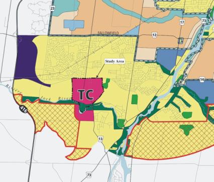
BACKGROUND
The
South Nepean Town Centre is an area of approximately 165 hectares in size
located in the southern end of the urban area of the City of Ottawa, as
illustrated in Document 1. The study
area's northern boundary is Strandherd Drive, its western boundary is the Kennedy-Burnett
Stormwater Management Facility, its eastern boundary is the future extension of
Longfields Drive, and its southern boundary is the Jock River. Although the Official Plan identifies lands
south of the Jock River as part of the South Nepean Town Centre, only the lands
north of the Jock River were considered
as part of the Community Design Plan.
The lands south of the Jock River were included as part of the Barrhaven
South Community Design Plan. "Town
Centre" throughout this report and throughout the Community Design Plan
refers only to the lands north of the Jock River.
The
Town Centre is surrounded by a number of established communities, including
Barrhaven, Longfields, and Stonebridge, and also lands for proposed new
communities, such as Barrhaven South and Chapman Mills. While the large majority of the study area
is currently undeveloped, there have been recent developments in the area such
as large-format retail projects along Strandherd Drive and a new secondary
school on Greenbank Road.
Approximately
87% of the total land area within the Town Centre is designated as Mixed Use
Centre in the Official Plan. Mixed Use
Centres are sited at strategic locations on the rapid-transit network, are to
be focal points of activity within the broader community, and have a high
potential for achieving compact and mixed-use development. The remaining 13% of the total land area,
located along the Jock River, is designated as Major Open Space, which are
areas intended to provide recreational opportunities for the larger community
while protecting the natural environment.
Additionally, the entire area has an overlay Town Centre designation,
one of the three such areas in the City, which additionally requires that a
minimum of 10,000 jobs must be accommodated within the area.
The
Official Plan requires the completion of a Community Design Plan (CDP) for all
Mixed Use Centres. Community Design
Plans are intended to translate the direction and policies of the City of
Ottawa Official Plan (2003) to the community level, by establishing the land
use framework of principles, objectives and policies that will guide
development within the community. They
are prepared as policy plans that operate between the policies of the Official
Plan and the development review process.
In the case of the South Nepean Town Centre, the key sections of the
Community Design Plan will be adopted as a statutory Secondary Plan to the
Official Plan, through the Official Plan Amendment proposed in Document 5.
The
Planning and Growth Management Department initiated the South Nepean Town
Centre Urban Design Strategy, which was undertaken by consultants to the City,
in February 2004 to provide the basis for a Community Design Plan. The South Nepean Town Centre Community
Design Plan (CDP) was initiated by City staff in November 2005 following the
completion of the Urban Design Strategy.
The CDP provides the detailed land use policies, urban design policies
and guidelines, servicing and transportation policies, and implementation
guidelines for the Town Centre. The CDP
was completed in May 2006.
This report seeks approval of the South Nepean Town Centre CDP and the proposed Official Plan Amendment that would: (1) replace the existing Area 7 Secondary Plan with a new South Nepean Town Centre Secondary Plan; and (2) would make revisions to the Official Plan's schedules to reflect the CDP. The approval of the South Nepean Town Centre CDP is required in order to support the proposed Official Plan Amendment.
DISCUSSION
The
South Nepean Town Centre has long been envisaged as the "downtown"
for the broader South Nepean area.
The Area 7 Secondary Plan is the
existing policy document that has guided land use planning decisions concerning
the Town Centre since 1997. The South Nepean
Town Centre Urban Design Strategy was completed in October 2005 to provide a
revised land use and urban design vision for the Town Centre to account for the
current realities within the area, such as new large format retail developments
and new directions regarding land use policy, rapid transit, and urban
design. The South Nepean Town Centre Community Design Plan was completed in
May 2006 based on the recommendations and will guide future development in the
Town Centre. The Area 7 Secondary Plan,
Urban Design Strategy and Community Design Plan are discussed in further detail
below.
Area 7 Secondary Plan
The
former City of Nepean initiated detailed visioning and planning for the Town
Centre in the early 1990s. Nepean City
Council endorsed the Nepean South Urban Activity Centre Concept Design Report
in 1994 as the guiding vision for the Town Centre’s future development. The Concept Design Report was undertaken as
part an integrated planning program of transportation, servicing,
environmental, and land use studies.
The Concept Design Report formed the basis for the preparation of the
Area 7 Secondary Plan, which Nepean City Council approved in 1997. The Area 7 Secondary Plan has remained as
the statutory planning document guiding development within the Town Centre
since its approval in 1997, after being readopted by the City of Ottawa in 2002
and reconfirmed in the Official Plan (May 2003), Volume 2A.
The
Area 7 Secondary Plan established a land use plan and policies, residential
densities, built form requirements and urban design guidelines to direct
development applications for lands within the Town Centre. The land use plan's key organizing elements
(Document 2) include two significant commercial districts along Strandherd
Drive; a north-south mixed-use civic axis along Greenbank Road; an east-west
mixed-use main street running through the centre of the community; four
residential quadrants defined by the intersection of the civic axis and the
main street and each organized around a neighbourhood park; a community park on
both sides of Jock River; and the opportunity for both east-west and
north-south rapid transit routes. The
Secondary Plan set ultimate build out targets of approximately 3,700
residential units and 8,000 residents at ultimate build-out based on the
established land use policies.
Urban Design Strategy
The
South Nepean Town Centre Urban Design Strategy was initiated in 2004 to update
the land use and design vision for the Town Centre, which was necessary given
new issues such as the Official Plan's new land use, transit and urban design
direction. A multi-disciplinary
consulting team, guided by the City's technical advisory committee, carried out
the Urban Design Strategy between February 2004 and October 2005 and involved a
substantial consultation process as described in the "Consultation"
section of this report. The final
document for the Strategy was submitted in October 2005 and set the framework
upon which the CDP was prepared.
The
final report for the Urban Design Strategy is comprised of four main
components: development principles that express the fundamental premises for development; a community structure plan that
highlights the main structuring elements around which the community is
organized; urban design principles that provide direction for the design of the
built environment's components; and a direction for implementation that
highlights a series of implementation lessons and priority action steps for
achieving the established vision.
The
community structure plan (Document 3) within the Urban Design Strategy closely
follows the major elements of the land use plan in the Area 7 Secondary Plan,
including major road alignments, park locations, and rapid transit route
alignments. However, the Urban Design
Strategy did have some noticeable differences from the Secondary Plan. These differences included a finer level of
detail for the local road and development block pattern; a detailed vision for
the higher density uses and civic uses around the "transit hub"; a
phasing strategy for the existing large-format retail areas; and a mixed-use
area north of Chapman Mills Drive that is broader and more flexible in terms of
permitted uses.
Community Design Plan
The
South Nepean Town Centre CDP was prepared by the Planning and Growth Management
Department between November 2005 and May 2006.
The CDP builds on the vision provided by the Urban Design Strategy in
establishing the policies and guidelines that will direct future land use planning
decisions concerning the Town Centre.
Four
key revisions to the structure plan proposed by the Urban Design Strategy were
made in the CDP's land use plan (Document 4) to account for new information and
directions provided by several Environmental Assessments that became available
after the completion of the Urban Design Strategy. These revisions include: (1) Shifting Chapman Mills Drive, and
the light rail corridor contained within it, to the south to be consistent with
the alignment of Chapman Mills Drive east of Longfields Drive; (2) Shifting
Greenbank Road slightly to the west near the bridge crossing of the Jock River
and widening the right-of-way to accommodate rapid transit within its medianed
central lanes; (3) Re-routing the South-West Transitway Extension within the
medianed central lanes on Chapman Mills Drive and Greenbank Road; and (4)
Shifting Longfields Drive south of Chapman Mills Drive slightly to west.
The
South Nepean Town Centre is intended to be a showcase for mixed-use, walkable,
transit-oriented neighbourhoods. The
overall land use and design vision for the South Nepean Town Centre is based on
six elements, as follows.
(1)
Development that is in a "urban" form, including:
·
Buildings close to the street and maximizing site
frontage and coverage;
·
Buildings between 2 and 12 storeys in height depending
on the area;
·
Built form oriented to the pedestrian realm;
·
Transit-oriented development surrounding transit stops;
·
An emphasis on structured parking and surface parking
in the rear.
(2)
Development based on high quality urban design standards, including:
·
Parks surrounded and fronted by built form;
·
Attractive, tree-lined streetscapes along all
streets;
·
Transitions in intensity between different areas within
the community;
·
Significant amounts of building façade articulation and
windows along public streets.
(3) A broad
range of land uses in a variety of forms, including:
·
Office, retail, service, institutional, open space, and
residential uses;
·
A flexible range of uses within different areas;
·
A regular pattern of blocks accommodates a range of
uses in various forms;
·
An emphasis on mixed-use both vertically in the same
building or horizontally on the same block;
·
Employment opportunities to enable live-work potential
within the community.
(4) A
diverse greenspace network, including:
·
A range of recreational opportunities for different
types of users;
·
Parks designed to complement the urban form;
·
Urban squares and plazas as the focus of different neighbourhoods;
·
A large district park along the Jock River in its natural
state.
(5) An
efficient transportation system, including:
·
A "transit hub" where two rapid transit
routes meet as the civic focus of the community;
·
A regular grid pattern of interconnected arterial,
collector and local streets;
·
A continuous network of sidewalks on both sides of all
streets.
(6) A
logical progression from the current to the ultimate built form, including:
·
Phasing to allow future infilling and redevelopment on
blocks;
·
Redevelopment opportunities for existing large format
retail sites;
·
The protection of future public right-of-ways and parks
during development;
·
A range of development potential in terms of density
and height to encourage redevelopment over time.
The
CDP contains five main sections: land use, urban design, transportation,
servicing, and implementation. A
summary of these sections is provided below.
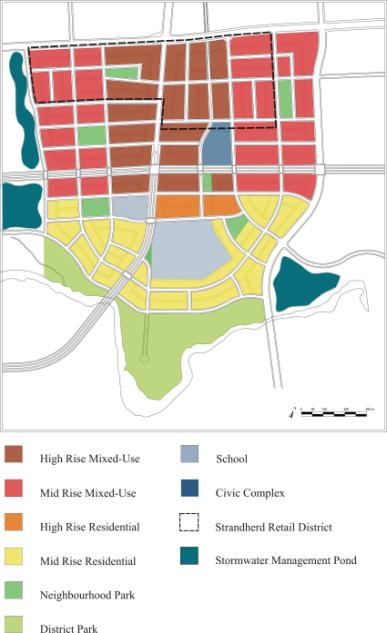
Land
Use
- Eight land use
policy areas identify the intent, permitted uses, and land use policies
for different areas of the Town Centre.
The "High Rise Mixed-Use" and "Low-Rise Mixed
Use" policy areas will permit a range of uses either in mixed-use or
single use buildings. The "High Density Residential" policy area
is limited to higher rise apartment buildings and the "Medium Density
Residential" policy area will accommodate the majority of
ground-oriented multiple unit dwellings.
The "School" policy area will primarily accommodate
schools and other community uses, while the "Civic Complex" will
accommodate a multi-use civic facility with various recreation and
community uses. The
"Neighbourhood Park" and "District Park" policy areas
will accommodate urban squares and a largely passive community park,
respectively, to support the urban nature of the Town Centre.
- Approximately 37%
of the Town Centre's land area is "Mixed-Use", 15% is
"Residential", and 22% is "School", "Civic
Complex" and "Park", with roads comprising the remaining
26%.
- The
"Strandherd Retail District", comprising the existing retail
developments along Strandherd Drive, is permitted to build-out as per current
zoning and master site plan permissions provided future intensification
and redevelopment that is permitted by the CDP is not jeopardized,
particularly concerning the acquisition of future public roads and
parkland.
- The build-out of
the Town Centre will take several decades to complete, depending mainly on
the market. Mid-term projections
for the Town Centre include 208,000 m2 of retail space, 158,000
m2 of office space, 6,600 dwelling units, 13,000 residents, and
7,300 jobs. Long-term projections
for the Town Centre include 218,000 m2 of retail space, 350,000
m2 of office space, 10,800 dwelling units, 21,000 residents,
and 12,000 jobs.
- Over 75% of all
dwelling units in the long-term build out phases are projected to be
apartment units.
- Five neighbourhood
parks are proposed within the Town Centre, which will be designed as urban
squares with a greater percentage of space as hard landscaped area and no
sports fields. The community park
along the Jock River, "Half Moon Bay Park", will be a largely open,
passive, natural park with the potential for a limited number of sports
fields.
- The convergence of
two rapid transit routes will be the civic centre of the Town Centre. A public plaza located on the south
side of Chapman Mills Drive will be largely passive in nature and hard
landscaped to accommodate pedestrian activities. A site on the north side of Chapman Mills Drive is reserved
for a multi-purpose civic complex that is proposed to be urban in
character with at least two storeys and largely with structured parking.
- Two schools are
identified in the Town Centre: the existing St. Joseph Secondary School on
the east side of Greenbank Road and a new elementary school on the west
side of Greenbank Road.
Urban
Design
- The urban design
section is comprised of both urban design policies and urban design
guidelines.
- Urban design
policies identify the general urban design requirements that must be met
by all development. The policies
include:
o
Maximizing building coverage;
o
Providing limits for building height of at least 2
storeys;
o
Orienting building façades to the public street;
o
Orienting primary building entrances to the primary
public street;
o
Siting buildings parallel to the public street;
o
Setting back building between 0 to 5.0 metres depending
on use;
o
Maximizing building frontage along public streets;
o
Providing at-grade uses that enhance the streetscape;
o
Creating variation in architectural elements along
building façades;
o
Providing a comfortable pedestrian realm;
o
Minimizing the physical and aesthetic impact of
mechanical equipment;
o
Minimizing the aesthetic impact on the streetscape of
parking areas; and
o
Providing "landmark" buildings at key
locations in terms of design and massing.
- Urban design
guidelines that provide guidance regarding specific design elements. They are grouped into four broad
categories:
o
Built form - including entrances, orientation, corner
sites, building stepping, signage, lighting, awnings, architectural continuity,
setbacks, windows, unit variation.
o
Streetscape - including amenities, bicycle parking,
sidewalks, crosswalks, transit stops, landscaping, tree location and planting.
o
Parking and Loading - including service areas, utility
equipment, surface parking and screening, garage entrances, parking structures.
o
Open Space and Connections - including mature trees,
mid-block walkways, active public space, park design, stormwater management
areas, outdoor amenity areas, trails and pathways, patios.
Transportation
·
The rapid transit network will consist of a light rail
transit (LRT) route running east-west in the centre, medianed lanes of Chapman
Mills Drive and a bus rapid transit (BRT) route running north-south through the
existing large-format retail developments on Strandherd, in the medianed lanes
of Chapman Mills Drive, and in the medianed lanes of Greenbank Road.
·
Three stops for the light rail transit and three stops
for the bus rapid transit are proposed within the Town Centre. The focus of the transit network is the
transit centre where the BRT and LRT routes cross each other.
·
Greenbank Road and Longfields Drive are the major
arterial roads that run north-south within the Town Centre, and Strandherd
Drive is the major arterial road that runs east-west. Chapman Mills Drive is the major collector road that runs
east-west through the Town Centre and is the "main street" of the
community. Numerous collectors and
local roads run throughout the Town Centre organized in highly connected and
permeable grid pattern.
·
Pedestrians will be accommodated with sidewalks on both
sides of all streets and also mid-block walkways where necessary. Cyclists will be accommodated on the major
roads with dedicated bike lanes and also minor collectors that extend across
the community.
·
Parking within the Town Centre will support the
development of an urban environment and will be focused on parking structures
and on-street parking in order to avoid the preponderance of large surface
parking areas.
Servicing
- Trunk water mains
along Strandherd Drive, Greenbank Road and Longfields Drive will service
the Town Centre for water supply purposes.
- The redesigned and
rebuilt Kennedy-Burnett Stormwater Management Facility and a new pond
adjacent to the east side of Longfields Drive will ultimately service the
Town Centre for stormwater management purposes.
- Collector sewers
along Longfields Drive and along Jockvale Road will service the Town
Centre for wastewater purposes.
- The electrical
utility network will be accommodated through underground services with the
main trunk lines along major roads within the Town Centre.
Implementation
- The plan for
implementation is multi-faceted in approach given the unique nature of the
Town Centre as compared to surrounding, primarily residential
communities.
- Applicants must
submit an "Area Concept Plan" together with the first
development application for an area to ensure the coordination of
development and the vision of the CDP will be met.
- All development, or
redevelopment in the case of the "Strandherd Retail District",
will proceed by plan of subdivision to ensure that the street and block
pattern is established from the outset.
- Approximately 2,700
dwelling units at ultimate build out, or 25% of the total dwelling units,
are targeted as affordable housing within the Town Centre: approximately 1,950 dwelling units (18%
of total) are targeted for "market" affordable housing and 750
dwelling units (7% of total) for "non-market" affordable
housing.
- Several initiatives
following the approval of the CDP will be required to support the CDP,
such as a parking strategy, streetscape master plan, and a disposition
strategy for City lands.
- The CDP establishes
the process for major revisions and identifies what revisions would
require approval of Planning and Environment Committee, such as major
deviations to street and block patterns or a changes in the land use
policy area.
- The City currently
owns approximately 26.3 hectares of land within the Town Centre, 8.83
hectares of which is intended for future parkland as per the land use
plan. A further 15.9 hectares of
land will need to be acquired to complete the proposed greenspace
network. The City will acquire
these lands through a combination of Planning Act parkland dedication,
land purchases, and land exchanges.
Proposed Official Plan Amendment
The
proposed Official Plan Amendment in Document 5 is the first step of
implementing the South Nepean Town Centre CDP.
The Amendment would replace the Area 7 Secondary Plan in Volume 2A of
the Official Plan with a new South Nepean Town Centre Secondary Plan, which
would be the new statutory planning document that would guide all future
development within the Town Centre. The
South Nepean Town Centre Secondary Plan is a shortened version of the Community
Design Plan and only contains the statutory portions of the Community Design
Plan, which include Section 2.0 - Goals and Objectives; Section 4.0 - Land Use;
Section 5.0 - Urban Design (not including the Design Guidelines); Section 6.0 -
Transportation; Section 7.0 - Servicing; Section 8.0 - Implementation; and
Schedules 1 through 6. The Sections and
Schedules identified above will be identical in both the Secondary Plan and the
Community Design Plan. The Community
Design Plan will be the document used to guide development applications, given
that it contains the urban design guidelines that City staff and proponents
will use during the development review process.
The
Amendment would also make six revisions to the schedules within the Official
Plan to account for revisions to the transportation network made as part of the
CDP, and supported by three concurrent
Environmental Assessment studies, and also to incorporate a recommendation from
the Urban Natural Feature Environmental Evaluation Study. The revisions to the schedules within the
Town Centre include:
- Redesignating some
lands on Schedule B north of the Jock River from "Major Open
Space" to "Urban Natural Feature", reflecting Urban Natural
Feature #49 from the Urban Natural Features Environmental Assessment
Study;
- Changing “On-Road
Cycling Routes” on Schedule C to follow the future alignments of
Longfields Drive and Greenbank Road;
- Realigning the
"Future Transit Corridors: Alignment Undefined" on Schedule D to
along both the future Southwest Transit Corridor/Greenbank Road and also
along the future Chapman Mills Drive;
- Adding
"Proposed Collectors" on Schedule E for five roads within the
Town Centre;
- Changing the
right-of-ways to be protected in Annex 1 of the Official Plan for
Greenbank Road and Longfields Drive;
- Changing the
“Proposed Major Collector” to "Proposed Collector" on Schedule E
reflecting the 'new' Jockvale Road; and
- Removing the “Major
Recreational Pathway” on Schedule I along existing Greenbank Road and
Jockvale Road within the Town Centre.
While the lands identified as Mixed Use Centre on Schedule B of the Official Plan, located south of Jock River, have historically been identified as being part of the Town Centre, they were not considered as part of the CDP study. It was determined early in the study process that these lands would be more appropriately dealt with as part of the planning study for all of the lands south of the Jock River, the Barrhaven South Community Design Plan. An Official Plan Amendment for the Barrhaven South CDP will redesignate these lands from Mixed Use Centre to General Urban Area.
ENVIRONMENTAL IMPLICATIONS
The
Urban Natural Areas Environmental Evaluation Study identified Urban Natural
Area #49, located along the Jock River, as a site worthy of protection. The portion on the north side of the Jock
River is largely owned by the City and, together with the remaining area, will
be preserved as part of the District Park policy area that applies to the land
within the CDP. The proposed Official
Plan Amendment in Document 5 seeks to redesignate these lands from "Major
Open Space" to "Urban Natural Feature". The larger portion of Urban Natural Area #49
that is south of the Jock River is being retained as part of the Barrhaven
South Community Design Plan.
The large majority of the limited amount of existing tree cover in the Town Centre is located within the area identified as "Community Park". The intent is to retain this area as a green and passive community level park. The City currently owns a large portion of these lands and the CDP directs that the remainder of the land will be acquired through various means.
CONSULTATION
Altogether,
six public meetings were held within the South Nepean community for both the
Urban Design Strategy and the Community Design Plan. Written comments received from these public meetings or
throughout the process in general together with staff responses are summarized
in Document 6. Councillor Harder has
been involved throughout the processes of both the Urban Design Strategy and
the Community Design Plan.
Notification
of the public meetings for both the Urban Design Strategy and the Community
Design Plan was undertaken through general flyers, the study's mailing list,
and the City's public consultation website.
Notification for the proposed Official Plan Amendment No. XX was carried
out in accordance with the Public Notification and Public Consultation Policy
approved by City Council for Official Plan Amendments.
The
first and second public meetings were held as part of a design workshop held on
March 31 and April 1, 2004 at the Jockvale Heritage Community Building and the
Walter Baker Centre. At this workshop,
participants had the opportunity to examine the existing conditions, establish
fundamental design principles, and develop and review preliminary land use concepts. Approximately 50 people attended the
workshop.
The
third public meeting was an open house held on June 23, 2004 at the Walter
Baker Centre. At this open house, an
evaluation of the optional concepts, a preliminary land use plan, and a set of
draft recommendations were presented for review and comment. Approximately 50 people attended the open
house.
The
fourth public meeting was an open house held on October 6, 2005 at the Walter
Baker Centre, as part of the Ward Councillor's community open house. At this open house, the final draft version
of the Urban Design Strategy document and the next steps for the Community
Design Plan were presented for review and comment and copies of the draft Urban
Design Strategy were available.
Approximately 60 people attended the Town Centre exhibit at the open
house.
The
fifth public meeting was an open house held on January 26, 2005 as part of the
Ward Councillor's community open house.
At this open house, the projected changes to the community structure
plan and the next steps for the Community Design Plan were identified. Copies of the final Urban Design Strategy
were available. Approximately 50 people
attended the Town Centre exhibit at the open house .
The sixth public meeting was held on April 6, 2006 at the Walter Baker Centre as part of the Ward Councillor's community open house. At this open house, the draft version of the Community Design Plan was presented for review and comment. Copies of the draft Community Design Plan were available to those interested. Approximately 100 people attended the Town Centre exhibit at the open house.
FINANCIAL IMPLICATIONS
The
development of major servicing infrastructure, parks and recreational trails
within the South Nepean Town Centre will be financed as per the new City of
Ottawa Development Charges By-law.
Development Charges - Parks
In
any particular year, new park construction within the Town Centre and Barrhaven
South will be implemented based on availability of DC revenues from growth,
needs in the area, and other priorities that may arise from time to time. Based on current unit projections in both
growth areas and anticipated park development costs, all proposed parks within
the Town Centre and Barrhaven South can be implemented without an impact to
other park development accounts.
Civic Complex
The
City of Ottawa's Recreation Infrastructure Strategy and Project Listing
includes a new recreation complex in Southeast Nepean to service growth. The time horizon for implementation will be
dependent on growth patterns and Long Range Financial Plan funding
availability. This complex is not
likely to be funded for construction until at least 2011.
The
Parks and Recreation Department expects the need for additional destination
types of civic installations, such as a library, a theatre, and cultural
program spaces, within the interim and ultimate build out of the Town
Centre. The site reserved for a Civic
Complex may prove to be the most suitable site for such installations as
well. Only the funding of the
recreation component of the Civic Complex is eligible for recovery of
development charges. The funding of the
other civic installations is ineligible for the recovery of development charges
and is currently not included in the Long Range Financial Plan and therefore
will be subject to future budget considerations.
Infrastructure and Utilities
The
Town Centre's envisioned urban form will likely incur additional costs for
development in terms of street infrastructure and utilities compared to
traditional suburban communities. The
initial capital costs of emplacing all infrastructure will be covered by a
combination of the conditions of development and development charges.
Street infrastructure
The
CDP proposes two elements for street infrastructure that depart from
traditional suburban development practices in Ottawa:
(1) Rear lanes,
either privately or publicly owned, are one preferred method in the CDP for
vehicular access to development blocks, in order to improve the pedestrian
realm and the overall aesthetics of the streetscape. The Town Centre will not be entirely rear lane based given other
methods of access are also permitted, depending on market preference, such as
rear parking areas accessed from the public street. The estimated incremental cost for operations and maintenance for
any publicly-owned rear lanes is approximately $9,600 per kilometre, which
includes $7,120 for snow removal, $1,370 for general maintenance, and $1,100
for streetlighting. The estimated
incremental cost for capital rehabilitation and replacement for publicly-owned
rear lanes is $10,000 per kilometre per year, which would be reflected through
adjustments in the Long Range Financial Plan.
(2) The CDP, following the existing policy direction in the Area 7 Secondary Plan, proposes sidewalks on both sides of all local streets. This policy is based on fact that densities in the Town Centre will generally be between three to ten times greater than those in traditional suburban communities and thus pedestrian activity will be much higher. The estimated incremental costs for operations and maintenance of an additional sidewalk is $3,000 per kilometre, but may be up to $8,000 per kilometre depending on the configuration of the right-of-way. The estimated incremental cost for capital rehabilitation and replacement is $2,500 per kilometre per year.
Utilities
The CDP is based on the full burial of main trunk hydro lines within the Town Centre, with the exception of the line along Strandherd Drive. As per Hydro Ottawa’s electrical expansion assessment of the Town Centre four new trunk lines would be needed: one along Greenbank Road, one along Chapman Mills Drive, one along the Longfields Drive, and one in the southern portion of the Town Centre between Greenbank Road and Longfields Drive. A commitment has already been made regarding the burial of the trunk line along Chapman Mills Drive, given the requirements of the LRT route. Hydro Ottawa has confirmed that they will continue to work with the City in implementing the burial of underground lines within the Town Centre to achieve the CDPs design objectives, provided that funding is available for such initiatives. Following the approval of the CDP, funding mechanisms would have to be established to cover the additional expenses.
SUPPORTING DOCUMENTATION
Document
1 - Map of South Nepean Town Centre CDP
study area
Document
2 - Area 7 Secondary Plan – Land Use
Plan
Document
3 - South Nepean Town Centre Urban
Design Strategy – Structure Plan
Document 4 - South
Nepean Town Centre CDP – Land Use Plan and Urban Design Demonstration Plan
Document
5 - Proposed Official Plan Amendment No.
XX
Document
6 - Summary of Submitted Comments
Document
7 - Civic Facilities
Document 8 - South Nepean Town Centre Community Design Plan (submitted under separate cover)
DISPOSITION
1. Department of Corporate Services,
Secretariat Services shall forward the South Nepean Community Design Plan to
Council for approval prior to its approval of Official Plan Amendment No. XX.
2. Department of
Corporate Services shall forward the implementing by-law to City Council, upon
request from the Planning and Growth Management Department, as per
Recommendation 2 of this report.
3. Planning and Growth Management Department shall
issue the Notice of Decision within 15 days of City Council adopting the
implementing by-law for Official Plan Amendment No. XX.
4.
Planning and Growth Management Department, through the next
general update of Official Plan, shall revise Annex 3 to the Official Plan to
indicate that the South Nepean Town Centre is subject to a Community Design
Plan.
DOCUMENT
1
MAPS OF SOUTH NEPEAN TOWN CENTRE CDP STUDY AREA
Map of study area within South
Nepean community
Map of study area within
Official Plan - Schedule B
DOCUMENT 2
AREA 7 SECONDARY PLAN – LAND USE PLAN
(ADAPTED FROM SCHEDULE A2)
The Land Use Plan from the Area 7
Secondary Plan represents the existing, approved land use policy that applies for
lands within the Town Centre. Nepean
City Council approved the Area 7 Secondary Plan in 1997. The Area 7 Secondary Plan has remained as
the statutory planning document guiding development within the Town Centre
since its approval in 1997, after being readopted by the City of Ottawa in 2002
and reconfirmed in the Official Plan (May 2003), Volume 2A.
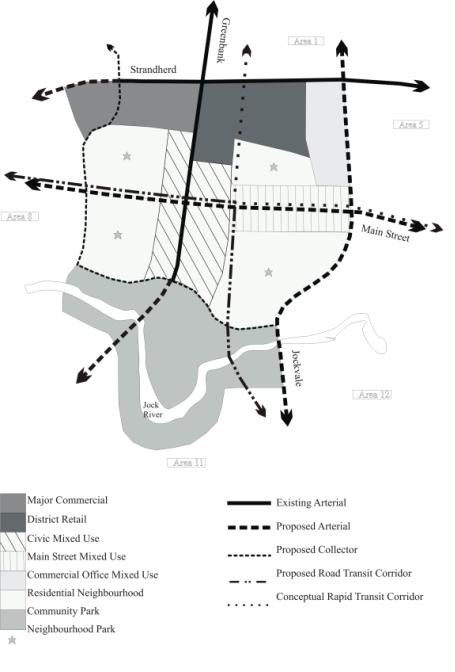
DOCUMENT 3
SOUTH NEPEAN TOWN CENTRE URBAN DESIGN
STRATEGY –
STRUCTURE PLAN
The Urban Design Strategy was
initiated as a land use and design study that would inform the preparation of
the South Nepean Town Centre Community Design Plan. The final document for the Urban Design Strategy is only
considered a background document, and is not considered policy. The Structure Plan within the document shown
here illustrates the potential ultimate buildout of the Town Centre based on
the recommended built form.
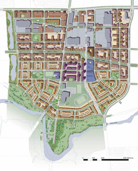
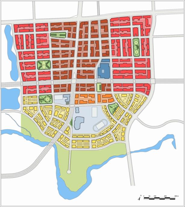
DOCUMENT 4
SOUTH NEPEAN TOWN CENTRE CDP - LAND USE PLAN AND
URBAN DESIGN DEMONSTRATION PLAN
The South Nepean Town Centre CDP represents the new land use and policy direction for the Town Centre, based on the recommendations of the Urban Design Strategy. The Land Use Plan provides the land use policy framework for future development, while the Urban Design Demonstration Plan illustrates the potential ultimate buildout based on the land use policies, urban design policies and urban design guidelines expressed within the CDP.
Land Use Plan
Urban Design Demonstration Plan
DOCUMENT 5
PROPOSED
OFFICIAL PLAN AMENDMENT NO. XX
|
|

Official Plan Amendment XX Modifications du Plan
directeur
To the
Official Plan of the City of Ottawa
Land
use
Utilisation
du sol
INDEX
Page
THE STATEMENT OF COMPONENTS
PART A - THE PREAMBLE
1.0 Purpose
2.0 Location
3.0 Basis
PART B - THE AMENDMENT
1.0 Introduction
2.0 Details
3.0 Implementation
ATTACHMENT 1
SCHEDULE 1
SCHEDULE 2
SCHEDULE 3
SCHEDULE 4
SCHEDULE 5
THE STATEMENT OF COMPONENTS
PART A – THE PREAMBLE, introduces
the actual Amendment but does not constitute part of Amendment No. XX to the
Official Plan (2003) of the City of Ottawa.
PART B – THE AMENDMENT,
consisting of text and schedules, constitutes the actual Amendment No. XX to the
Official Plan (2003) of the City of Ottawa.
PART A - THE PREAMBLE
1.0 Purpose
The purpose of Amendment No. XX
is to replace the existing Secondary Plan for the South Nepean Town Centre
(Area 7) within Volume 2A of the Official Plan (2003) with the South Nepean
Town Centre Community Design Plan, a new Secondary Plan for the area, and also
to make revisions to four schedules within the Official Plan, regarding
cycling, transit, road and recreational routes, resulting from the new
transportation network proposed within the Town Centre.
2.0 Location
The subject lands are located
within the South Nepean Town Centre between Strandherd Drive to the north, the
Jock River to the south, the Kennedy Burnett Stormwater Management Facility to
the west, and the future extension of Jockvale-Longfields Drive to the
east. The subject lands are
approximately 165 hectares in size. The
subject lands are largely designated as Mixed Use Centre (Town Centre) within
the Official Plan while lands along the Jock River are designated as Major Open
Space.
3.0 Basis
The former City of Nepean adopted
the “Secondary Plan for South Nepean Area 7” in 1997 following an integrated
planning program that included transportation, servicing, environmental, and
land use planning studies. This
Secondary Plan has been the statutory planning document that has guided
development within the Town Centre since 1997.
In February 2004, the City
initiated the South Nepean Town Centre Urban Design Strategy to provide an
updated direction for the Town Centre, given several issues that emerged since
the Secondary Plan’s adoption such as the Official Plan’s new policy direction
and new proposed rapid transit routes within the Town Centre. The Urban Design Strategy was completed in
December 2005. Following the Urban
Design Strategy’s completion, in January 2006 City staff initiated the South
Nepean Town Centre Community Design Plan (CDP) based on the recommendations of
the Urban Design Strategy. The CDP will
guide the development of the Town Centre as a compact, mixed-use, walkable,
pedestrian-scaled, and transit-supportive community.
The Planning and Growth
Management Department are proposing that the key components of the CDP be
adopted as a Secondary Plan to the City of Ottawa Official Plan (2003), which
would be the statutory land use planning document guiding future decisions
concerning the Town Centre. The
Department is seeking to adopt parts of the CDP as a new Secondary Plan in
order to give the same status as the previous planning document, the Area 7
Secondary Plan, given the importance of certain elements of the Plan, such as
minimum heights or the road pattern, for achieving the overall vision for the
Town Centre.
Official Plan Amendment No. XX
will implement the new policy direction by replacing the existing Secondary
Plan in Volume 2A of the Official Plan with the new South Nepean Town Centre
Secondary Plan and also by revising certain schedules in the Official Plan to
reflect Secondary Plan. The changes to
the schedules include:
·
Redesignating some lands on Schedule B north of the
Jock River from "Major Open Space" to "Urban Natural
Feature", reflecting Urban Natural Feature #49 from the Urban Natural
Features Environmental Assessment Study;
·
Changing “On-Road Cycling Routes” on Schedule C to
follow the future alignments of Longfields Drive and Greenbank Road;
·
Realigning the "Future Transit Corridors:
Alignment Undefined" on Schedule D to along both the future Southwest
Transit Corridor/Greenbank Road and also along the future Chapman Mills Drive;
·
Adding "Proposed Collectors" on Schedule E
for five roads within the Town Centre;
·
Changing the “Proposed Major Collector” to
"Proposed Collector" on Schedule E reflecting the 'new' Jockvale
Road; and
·
Removing the “Major Recreational Pathway” on Schedule I
along existing Greenbank Road and Jockvale Road within the Town Centre.
PART B - THE AMENDMENT
1.0 Introduction
All of this part of this document
entitled Part B – THE AMENDMENT, consisting of the following changes,
constitutes Amendment No. XX to the Official Plan (2003) of the City of Ottawa.
2.0 Details
The City of Ottawa Official Plan
is hereby amended as follows:
(1) Volume 2A of
the Official Plan is amended by removing the “Secondary Plan for the South
Nepean Area 7”;
(2) Volume 2A of
the Official Plan is amended by adding the “South Nepean Town Centre Secondary
Plan” in Attachment 1 of this Amendment as a Secondary Plan to the Official
Plan;
(3) Schedule B
of the Official Plan is amended to reflect Schedule 1 of this Amendment;
(4) Schedule C
of the Official Plan is amended to reflect Schedule 2 of this Amendment;
(5) Schedule D
of the Official Plan is amended to reflect Schedule 3 of this Amendment;
(6) Schedule E
of the Official Plan is amended to reflect Schedule 4 of this Amendment; and
(7) Schedule I of
the Official Plan is amended to reflect Schedule 5 of this Amendment.
3.0 Implementation
The amendment shall be
implemented by the powers conferred upon the City of Ottawa by the Planning
Act, Municipal Act, and any other statutes that may apply.
Attachment 1

South Nepean Town Centre
Secondary Plan
June 2006
Community Planning and
Design Division
Planning and Growth
Management Department
Section 1.0 – Introduction
1.1 Secondary Plan Area
The South Nepean Town
Centre is an area of approximately 165 hectares in size located in the southern
portion of the City of Ottawa’s urban area.
The Town Centre’s northern boundary is Strandherd Drive, its western
boundary is the Kennedy-Burnett Stormwater Management Facility, its eastern boundary
is the future extension of Longfields Drive, and its southern boundary is the
Jock River. The established residential communities of
Barrhaven and Longfields surround the Town Centre to the north; the partially
developed Chapman Mills community and established Heart’s Desire community is
adjacent to the east; the existing Stonebridge community is to the southeast;
the proposed Barrhaven South community is to the southwest; and the undeveloped
“Area 8” lands are to the west.
The large majority of the study area is currently
undeveloped. The Barrhaven Town Centre
and RioCan Marketplace, large-format retail projects to the west and east of
Greenbank Road, respectively, have been substantially completed along Strandherd
Drive and St. Joseph Secondary School was recently constructed along Greenbank
Road. There are existing residences
along Greenbank Road, both in the centre of the Town Centre and further south
adjacent to the Jock River. Existing
farm operations and commercial businesses make up the remainder of land uses
within the Town Centre. The study area
is largely comprised of unwooded field areas, with the exception of wooded
areas immediately surrounding the Jock River.
1.2 Background
The former City of Nepean
initiated a detailed visioning exercise for the Town Centre in the early
1990s. Resulting from this exercise,
Nepean City Council endorsed the Nepean South Urban Activity Centre Concept
Design Report in 1994 as the vision for the Town Centre’s future
development. Subsequently, Nepean
undertook an integrated planning program, including transportation, servicing,
environmental, and land use planning studies that resulted in the adoption of
the Area 7 Secondary Plan by Nepean City Council in 1997. The Secondary Plan established land use
policies, residential densities, built form requirements and urban design
guidelines. The Area 7 Secondary Plan
has remained as the statutory planning document guiding development within the
Town Centre since its approval in 1997, after being readopted by the City of
Ottawa in 2002 and reconfirmed in the Official Plan (May 2003), Volume 2A.
However much has changed since the approval of the Area 7 Secondary Plan in 1997. Several significant large-format retail projects have been constructed along Strandherd Drive, a new land use policy direction was established in the Official Plan with a particular emphasis on urban design, and new strategic directions for rapid transit routes have been established for the Town Centre. The emergence of these issues necessitated the preparation of an updated land use and design vision for the Town Centre.
The South Nepean Town Centre
Urban Design Strategy was initiated in 2004 to
provide this updated vision. The Urban
Design Strategy outlines the goals and objectives, describes the land use
structure plan and its structuring elements, identifies a series of urban
design principles to follow, and provides direction for implementation. The Urban Design Strategy was completed in 2005
and was the visioning document that guided the preparation of the South Nepean
Town Centre Community Design Plan (CDP).
The Urban Design Strategy is not considered planning policy.
The Town Centre CDP was prepared based on the recommendations of the Urban Design Strategy. As part of the Town Centre CDP process, some modifications to the Strategy’s land use vision were required to account for new street and transit alignments that were provided by several Environmental Assessment (EA) studies after the completion of the Strategy. These EA studies provided more detailed direction for Chapman Mills Drive (North-South Light Rail EA), Greenbank Road (Greenbank Road EA), Longfields Drive (Jockvale-Longfields Extension EA), and the Southwest Transitway corridor (Southwest Transitway Extension EA). These modifications to the Town Centre structure were made in keeping with the overall vision presented by the Urban Design Strategy.
The South Nepean Town Centre Secondary Plan is based entirely on the key components of the South Nepean Town Centre Community Design Plan. All goals, objectives, policies and schedules are the same in both documents. The Community Design Plan contains non-statutory components such as urban design guidelines.
Section
2.0 – Goals and Objectives
The foundation of the Secondary Plan is a set of goals and objectives that provide the framework for future development in the Town Centre, based on the Urban Design Strategy. The goals and objectives expressed in Sections 2.1 to 2.6 are not prioritized and are overlapping, thus they must be considered together when making land use and design decisions regarding the Town Centre.
2.1 Goal 1 – Compact Urban Form
Goal: Development
that reflects a dense, compact and transit-supportive built form.
Objectives:
(1)
To
develop a focal point within South Nepean to provide a common identity and
focus for surrounding communities;
(2)
To support the
viability of transit by coordinating land use, transportation infrastructure
and urban design in a mutually complementary manner;
(3)
To
facilitate the development, intensification, and redevelopment of the Town
Centre in an urban fashion, including buildings, streetscapes and open spaces;
and
(4)
To
provide flexibility for the use of land, including opportunities for retail and
office commercial, residential, institutional and community buildings.
2.2 Goal 2 – High Quality Urban Design
Goal: High-quality urban design for all
development, both public and private.
Objectives:
(1) To achieve high quality urban design for development
that reflects the role of the Town Centre as South Nepean focus;
(2) To create a strong community image by enhancing the character of the
built environment including building design and massing, signage, and planting;
(3) To provide a transition between areas with different densities within the
Town Centre and also between the Town Centre and adjacent lower density
communities;
(4) To develop attractive streetscapes during the design of the public realm,
built form, streetscapes and other public areas; and
(5) To encourage the use of ‘green’ technologies in the design of new
buildings and infrastructure.
2.3 Goal 3 – Mixture of Land Uses
Goal: Provision of a broad range of retail,
office, institutional, and residential uses.
Objectives:
(1)
To
promote the development of a mixed-use area to create an attractive working and
living atmosphere;
(2)
To provide a
variety of low-rise, mid-rise and high-rise building forms in order to provide
different household types with housing choices;
(3)
To
provide an adequate supply of affordable housing for moderate-income and
low-income households within the Town Centre;
(4)
To
ensure that residential and non-residential uses are compatible and
complementary to each other;
(5)
To
encourage the establishment of social services, parks, public facilities and
public transit services in locations which are conveniently accessible; and
(6)
To
provide a sufficient number of employment opportunities within the Town Centre
to enable residents in South Nepean to work within the community.
2.4 Goal 4 – Diverse Greenspace Network
Goal: Provision of a diverse greenspace network.
Objectives:
(1) To establish a range of recreation opportunities to meet the needs of the
resident and worker population;
(2) To design parks and open spaces to complement a compact, urban
environment;
(3) To develop a pedestrian and bicycle network that connects parks, public
buildings, stormwater management areas, local streets, the Jock River and
surrounding communities; and
(4) To protect the ecological health and integrity of the Jock River and
surrounding natural features.
2.5
Goal 5 – Efficient Transportation
System
Goal: Provision
of an efficient, multi-modal transportation network.
Objectives:
(1) To incorporate rapid transit routes within a compact, urban built
environment in order to increase public transit ridership and to reduce traffic
congestion, energy costs and pollution.
(2) To develop a grid of continuous and interconnected arterial, collector
and local streets and laneways facilitating efficient movement by all modes of
transportation.
(3)
To develop a pedestrian-friendly, tree-lined,
and bicycle-friendly system of streets that is well connected to public
facilities, parks, commercial areas and surrounding communities.
(4) To provide a system of on-street parking to support ground floor uses,
particularly retail commercial uses, while avoiding large surface parking
areas.
2.6
Goal 6 – Anticipation of Growth
Goal: A
logical progression of development from initial phases to a mature state
reflecting the envisioned urban form.
Objectives:
(1)
To permit interim forms of development to
occur while protecting for the achievement of the Town Centre’s ultimate built
form; and
(2) To ensure that infrastructure improvements are
comprehensively planned to address the needs of development within the Town
Centre; and
(3) To ensure that the City promotes and participates in the early
development of the public realm, including public buildings, high order transit
services, on-street parking, and urban squares and plazas; and
(4) To ensure that the establishment of the Town Centre as a transit focal
point for South Nepean is maintained and protected.
Section 3.0 – Land Use Plan
The
land use policies in this Section set the framework for land use planning
within the Town Centre. Based on these
policies, the Town Centre could accommodate over 22,000 residents and over
12,000 employment opportunities (see Tables 2 and 3) at ultimate
build-out. The success of the Town
Centre will not be judged in the short term, but will be determined in the
long-term timeframe when the ultimate build-out as envisioned by this Secondary
Plan would occur.
3.1 General Land Use Policies
The land use plan contained in Schedule 1 is comprised of eight land use
policy areas, described in Sections 3.2 through 3.9. These policy areas identify the intent, permitted uses, and land
use policies for specific areas of the Town Centre. The general land use policies in this Section apply to all eight
policy areas within the Town Centre.
Policies
For all lands within
the Town Centre:
(1)
The “Generally
Permitted Uses” in Section 3.1 of the Official Plan are permitted in all of the
policy areas. Additionally, all
municipal facilities and utilities shall be permitted in all land use policy
areas.
(2)
Parking
standards will be determined by the Zoning By-law and will be guided by Section
3.4 (7).
(3)
Affordable
housing targets for residential developments are expressed in Section 8.6.
(4)
The density
targets identified in Sections 3.2 through 3.6 are ultimate build out targets
and are to be considered on an area basis and not by each development
block. While these targets may not be
achieved from the outset, it must be demonstrated, as per Section 8.3, how
these targets could be met in the long-term timeframe.
(5)
The urban
design policies and urban design guidelines in Section 4.0 apply to all
development, subject to Sections 3.2(7) and 3.3(5).
(6)
The following
uses are not permitted, except for sites within the “Strandherd Retail
District” that have existing zoning or master site plan permissions permitting
such uses:
(a)
Individual
retail uses in stand-alone buildings with ground floor plates greater than
5,750 square metres;
(b)
Gas stations;
(c)
Drive-through
facilities; and,
(d)
Retail uses
that require outdoor storage, with the exception of a seasonal garden centre
ancillary to another permitted retail use.
(7)
Private plazas will be
encouraged for all private sector developments. Their actual size,
configuration and design will be subject to confirmation by the City during the
approval process. Private plazas:
(a)
Include a range
of forms, such as patios, terraces, and courtyards;
(b)
Will not be
used as part of parkland dedication;
(c)
Will not be designated as separate open space blocks
on the land use plan; and
(d)
Will be encouraged to be surrounded by built form
edges and be connected with landscaped mid-block connections or pedestrian
mews.
Table 1 – Land Use Distribution
Policy Area
|
Net Area (hectares) |
% of Total Area |
|
High
Rise Mixed-Use |
26.5 |
16.1% |
|
Mid Rise Mixed-Use |
34.2 |
20.7% |
|
High Rise Residential |
3.4 |
2.1% |
|
Mid
Rise Residential |
21.9 |
13.2% |
|
School
|
7.9 |
4.8% |
|
Civic
Complex |
2.2 |
1.3% |
|
District
Park |
21.6 |
13.1% |
|
Neighbourhood
Park |
4.5 |
2.7% |
Streets
|
42.8 |
25.9% |
Total
|
165.0 |
100.0% |
Table 2 – Dwelling Type Distribution
|
Dwelling Type |
# of Dwellings |
% of Total Dwellings |
|
Phase 2 |
|
|
|
Street
Townhouses |
1,000 |
14% |
|
Stacked
Townhouses |
750 |
10% |
|
Apartments |
5,500 |
76% |
|
Total |
7,250 |
100% |
|
|
|
|
Phase 3
|
|
|
|
Street
Townhouses |
1,000 |
9% |
|
Stacked
Townhouses |
750 |
7% |
|
Apartments |
9,300 |
84% |
|
Total |
11,050 |
100% |
Table 3 – Land Use Statistics
Phase
|
Retail Gross Floor Area (m2) |
Office Gross Floor Area (m2) |
# of Dwelling Units |
Population |
Employment |
|
Phase
1 – Initial |
78,000 |
1,000 |
0 |
0 |
1,000 |
|
Phase
2 – Interim Built Out |
208,250 |
158,250 |
7,250 |
14,500 |
7,300 |
|
Phase
3 – Ultimate Build Out |
217,000 |
350,500 |
11,050 |
22,500 |
12,600 |
Notes:
(1) Tables 2 and 3 indicate projections of different build out scenarios. Given the long-term nature of the scenarios, these figures should only be considered as potential build out projections based on permissions by the policies in this CDP.
(2) Numbers for each phase are total, not
cumulative.
(3) Phase 1 does not include the limited
residential units currently within the Town Centre.
(4) The type of units identified in Table 2 are
intended to only illustrate the intensity of units, and not necessarily limit
the form of units.
3.2 Policy Area – High Rise Mixed-Use
The High Rise Mixed-Use policy area represents the primary retail and
mixed-use development area within the Town Centre. The High Rise Mixed-Use policy area will be a lively and active
mixed-use shopping district, with an emphasis on commercial and residential
uses in the same building with retail uses located at-grade, but also single
use retail and office commercial uses and residential apartments.
Policies
For the High Rise
Mixed-Use policy area:
(1)
Apartments, a
broad variety of retail, office and service commercial activities, public and
institutional uses, schools, places of worship, and community facilities are
permitted.
(2)
The minimum
building height is 6 storeys and the maximum building height is 12 storeys.
(3)
The net density
target for residential uses is 250 units per hectare.
(4)
The maximum lot
coverage for stand-alone residential buildings is 30% of the total area of any
block.
(5)
All building
frontage along Greenbank Road and Chapman Mills Drive must have non-residential
uses at grade.
(6)
The City will
encourage that all buildings along the BRT route north of Chapman Mills Drive
incorporate the route as much as possible into the design of the building,
through such means as clear windows or secondary doors.
(7)
The above
policies in Section 3.2 or the policies and guidelines of Section 4.0 do not
apply to future development in the “Strandherd Retail District” that is
permitted by existing zoning or master site plans, provided that this
development does not jeopardize the long-term acquisition of the public streets
identified on Schedule 2 or public parkland identified on Schedule 5. For this new development, the City will
still encourage the consideration of the urban design policies and guidelines in
Section 4.0, as they may apply, during the development review process.
3.3 Policy Area –
Mid Rise Mixed-Use
The Mid Rise Mixed-Use policy area represents a lower scale, mixed-use
area within the Town Centre with the intent of establishing opportunities for
live-work units and medium density housing forms. The Mid Rise Mixed-Use policy area is intended to be a transition
between the High Rise Mixed-Use policy area and the adjacent lower density
residential neighbourhoods, both within the Town Centre an in surrounding
communities.
Policies
For the Mid Rise
Mixed-Use policy area:
(1)
Apartments,
live-work units, retail, office and service commercial uses, public and
institutional uses, schools, places of worship and community facilities are
permitted.
(2)
The minimum
building height is 4 storeys and the maximum building height is 6 storeys.
(3)
The net density
target for residential uses is 200 units per hectare.
(4)
The maximum lot
coverage for stand-alone residential buildings is 50% of the total area of any
block.
(5)
The above
policies in Section 3.3 or the policies and guidelines of Section 4.0 do not
apply to future development in the “Strandherd Retail District” that is
permitted by existing zoning or master site plans, provided that such
development does not jeopardize the long-term acquisition of the public streets
identified on Schedule 2 or public parkland identified on Schedule 5. For this new development, the City will
still encourage the consideration of the urban design policies and guidelines
in Section 5.0, as they may apply, during the development review process.
3.4 Policy Area – High Rise Residential
The High Rise Residential policy area identifies sites within the Town
Centre that will accommodate the highest density residential uses, located in
proximity to the transit “hub”.
Apartment buildings will be the only residential type permitted.
Policies
For the High Rise
Residential policy area:
(1)
Apartments are
the only permitted use. As part of an
apartment building, retail, office and commercial uses at grade are also
permitted.
(2)
The minimum building
height is 6 storeys and the maximum building height is 12 storeys.
(3)
The net density
target for residential uses is 300 units per hectare.
(4)
At least 90% of
required parking for each development must be provided in parking structures,
either above-grade or below-grade.
3.5 Policy Area – Mid Rise Residential
The Mid Rise Residential policy area is intended to accommodate the
majority of the Town Centre’s ground-oriented multiple unit dwellings. This policy area will provide an appropriate
transition between the low density neighbourhoods surrounding the Town Centre
to the higher intensity uses within it.
Policies
For the Mid Rise
Residential policy area:
(1)
Apartments,
street, block and stacked townhouses, public and institutional uses, schools,
places of worship and community facilities are permitted. Ground floor retail uses within a mixed-use
building with residential uses above are permitted along Greenbank Road.
(2)
The minimum
building height is 2 storeys and the maximum building height is 4 storeys.
(3)
The net density
target for residential uses is 100 units per hectare.
3.6 Policy Area – Neighbourhood Park
The
Neighbourhood Park policy area will include both public parks and public
plazas. The five
public parks within the Town Centre will be designed to support the area’s
urban nature, as accessible amenities with open frontages and clearly defined
entrances that work within the grid pattern of streets and blocks. The two public plazas within the Town Centre
will be designed as predominately hard surfaced areas fronted by buildings in
order to create a built form edge and generate pedestrian activity.
Policies
For the Neighbourhood Park policy area:
(1)
Public parks,
public plazas, community facilities, and conservation uses are permitted.
(2)
The locations of
the five public parks and the two public plazas are identified on Schedule
5.
(3)
Acquisition of
all neighbourhood parks will be as per Section 8.4 and Schedule 5.
(4)
Public parks
must:
(a) Generally be between 0.4 and 1.0 hectares of
level land;
(b) Have at least three sides that are entirely
open to the street;
(c) Not have rear or side yards adjacent on their
fourth side;
(d) Be
designed with an emphasis on hard surfacing and seating areas as compared to
traditional suburban neighbourhood parks; and
(e) Not
contain sports fields.
(5)
Public plazas must:
(a)
Generally be
less than 0.4 hectares of level land;
(b)
Be landscaped with street trees and other vegetation
and include seating areas with furniture;
(c)
Be considered as locations for public art;
(d)
Be designed with an emphasis on hard surfacing and
seating areas as compared to traditional suburban neighbourhood parks; and
(e)
Not accommodate sports fields or traditional
suburban play amenities.
3.7 Policy Area – District Park
The
District Park policy area will accommodate the establishment of “Half Moon Bay
Park”, a large
and natural park that is focused on passive recreation areas, but with some
opportunities for active recreation uses. Half Moon
Bay Park will extend the entire width of the Town Centre along the Jock River
and is intended to be a focal point of the greenspace system in the area,
connecting with existing and future greenspace components in surrounding
communities.
Policies
For the District Park policy area:
(1)
Public parks, conservation management and control uses, trails, walkways
and bicycle paths, educational facilities, sports fields and recreational
facilities, existing uses as per Section 3.7(4), and buildings accessory to
other permitted uses are permitted.
Active recreation facilities such as sports fields are also permitted as
long as the general intent of this park is maintained.
(2)
For the design of Half Moon Bay Park:
(a) Pedestrian
crossings of the river will be clearly defined;
(b) Vehicular
access will be limited to certain points and parking will be provided in small
pods with significant landscaping;
(c) The use of
permeable surfaces for any hard-surfaced areas will be investigated;
(d) Internal
streets will be designed to be rural in character;
(e) Public works will be located outside of
natural features unless it is demonstrated that there is no reasonable
alternative and then only if such works meet the requirements of the Official
Plan; and
(f) All uses
will be designed to ensure limited disruption to natural features and an Environmental Impact Statement is required
to establish the appropriate development buffer from any identified natural
features on the site.
(3)
The City will
work with the Conservation Authority, local interest groups, and interested
advisory committees in the creation of a continuous, interconnected trail system
and the protection and rehabilitation of identified natural features within
Half Moon Bay Park.
(4)
Existing homes
and commercial operations within the Community Park policy area are recognized
as conforming uses, as per
Section 3.3(4) of the Official Plan.
Landowners have the right to improve the properties in conformity with
the existing zoning standards on the property.
The City intends to acquire these properties as per Section 7.4(9).
(5)
Half Moon Bay Drive will be designed as a “parkway”
type of street, as per Section 6.2, with development only on its north side to
ensure the preservation of views and vista of the park and the Jock River.
3.8 Policy Area – School
The School policy area will primarily accommodate school uses, but also
can accommodate other community uses.
The School policy area provides the opportunity to locate facilities
that will serve an important role in attracting people to the Town Centre, thus
generating a high level of social activity.
Policies
For the School policy
area:
(1)
Schools,
community facilities, and places of worship are permitted.
(2)
The minimum
building height is 2 storeys and the maximum building height is 6 storeys.
(3)
The alternative
policy area for the site west of Greenbank Road is Mid Rise Residential if the
site is not utilized for its intended purpose.
3.9 Policy Area – Civic Complex
The Civic Complex
policy area will accommodate the development of a multi-purpose civic facility
that will serve the broader South Nepean community. The facility is located directly adjacent to the transit hub and
together with the central public plaza and surrounding buildings will be the
civic focus of the Town Centre.
Policies
For the Civic Complex policy area:
(1)
As part of a
multi-purpose civic complex, a range of community uses is permitted, such as
ice pads, swimming pools, courts, day cares, community halls, theatres,
museums, libraries, or public health space, in addition to retail and office
uses through joint arrangements with private sector partners.
(2)
The civic
complex is intended to be urban in form, with buildings constructed close to
the street and a majority of required parking accommodated in structured
parking.
(3)
The minimum
building height is 2 storeys and the maximum building height is 6 storeys.
The alternative policy area for the Civic
Complex site is High Rise Mixed-Use if the site is not utilized for its
intended purpose.
Section 4.0 – Urban Design
High quality urban design within the Town
Centre will be critical for achieving an urban environment with a compact built
form, a wide range of different uses, a convergence of high order transit
routes, and a strong civic identity for South Nepean. The framework for urban
design within this Secondary Plan consists of both urban design policies and
urban design guidelines. Appendix C
graphically illustrates the potential ultimate build out of the Town Centre
based on the urban design policies and guidelines in this Section. Appendix D illustrates this potential for
the different phases of the Strandherd Retail District’s evolution.
4.1 Urban Design Policies
The following urban design policies
apply to all development within the Town Centre, except where certain design
policies would contradict Section 3.2(7) and 3.3(5) regarding the Strandherd
Retail District. They express the general objectives covering
broader issues that must be met by all development. The policies are general in nature to permit flexibility during
the design process while ensuring a minimum urban design standard is met.
Policies
(1)
Buildings must maximize the coverage of lots.
(2)
Buildings must be at least two fully
functioning storeys in height, with different areas having greater minimum
building heights as per Section 4.0.
(3)
Buildings must be functionally and
visually oriented to the public street and sited to be parallel to
the public street and generally aligned with neighbouring buildings.
(4)
Principal building entrances must be
oriented to the public street and not to rear parking areas or lanes.
(5)
Building
design must address issues of adequate sunlight, sky views, and wind
conditions.
(6)
Buildings
must be developed with a substantial portion of any visible front façade from a
public street within 5.0 metres of the respective property line.
(7)
Building
frontage must be maximized along all public streets.
(8)
At-grade
uses must be flush with grade and provide an active use at grade in order to
promote pedestrian activity.
(9)
Spaces
between the building wall and the street must provide an appropriate transition
from the private realm to the public realm.
(10) Buildings
must have dynamic façades with limited areas of blank, featureless walls.
(11) All
parking, including surface, below-grade, and above-grade, must not detract from
the aesthetic appearance of any public streetscape.
(12) Buildings
and structures located at key locations must be designed and massed to
emphasize their locations.
4.2 Urban Design
Guidelines
The urban design guidelines provide specific design guidance on
particular issues and elements within the Town Centre. The design guidelines are not considered a
“design checklist”, but instead are to be applied on a case-by-case basis. While not considered policy, the City will
use these guidelines during the review of development applications.
Policies:
(1) All development must have regard to the urban design guidelines in Section 5.2 of the South Nepean Town Centre Community Design Plan.
Section 5.0 – Transportation
The transportation network in the Town Centre
will be an accessible and sustainable system focused on non-automobile modes of
transportation, such as public transit, cycling and walking. This transportation network contains four
components: the transit network, the street network, the pedestrian and cyclist
network, and the parking network. The
proper design of all components is critical to achieving the built form and
urban design objectives for the Town Centre.
5.1 Transit
Network
Two rapid transit lines will service the Town Centre, one oriented east
to west and operated with light rail transit (LRT) and one oriented north to
south and operated with bus rapid transit (BRT). The LRT route will operate in the central lanes of Chapman Mills
Drive that are divided from automobile traffic with landscaped medians. The BRT will operate in a dedicated transit
corridor north of Chapman Mills Drive, and in the central lanes of both Chapman
Mills Drive and Greenbank Road south of Chapman Mills Drive.
Three LRT stations are proposed along Chapman Mills Drive: the eastern
station at Longfields Drive; the central station at the LRT and BRT intersection;
and the western station at Jockvale Road.
Three stops for the BRT are proposed within the Town Centre: one north
of Chapman Mills Drive, one on Chapman Mills Drive, and one south of Chapman
Mills Drive. The transit focus of the
South Nepean Town Centre is at the intersection of the LRT and BRT routes. This transit “hub” will be a public transit
focal point for the broader community, at which both residents within the Town
Centre and transit users transferring from local buses serving nearby residential
and commercial areas can access rapid transit services. The transit network will evolve over time as
the construction of the rapid transit lines, development within the Town
Centre, and development within the surrounding residential and commercial areas
occurs.
Policies
(1) The proposed LRT and BRT alignments and
station locations are identified on Schedule 3. The alignment of the routes and the location of stations have
been identified by Environmental Assessment studies prepared for both the westward
extension of the North-South Light Rail Transit project and the Southwest
Transitway Extension.
(2) All
development must follow the principles of transit-oriented development,
including considerations for Section 4.3 of the Official Plan and urban design policies
and guidelines of this Secondary Plan.
(3) The City will undertake the development of a
conceptual design plan for the transit “hub” at the intersection of the LRT and
BRT routes, as per Section 7.6. This
design will illustrate how the transit “hub” will accommodate such elements as
pedestrian travel routes, buildings close to the street, landscaping, street
furniture, and the central public plaza.
(4) Park & Ride facilities will not be
located within the Town Centre in the long-term.
(5) In the short-term, arterial, major collector,
and collector streets will accommodate local transit services that provide
service to the existing termini of the rapid transit network. In the long-term, the rapid transit
facilities will carry most of the frequent and long distance services while the
local transit service will be changed to local service to the Town Centre and
may be removed from some streets altogether.
5.2 Street
Network
The street network is
organized to connect the Town Centre with surrounding communities, provide a
pattern of regular development blocks, and integrate different neighbourhoods
within the Town Centre. The basis of
the street network is a hierarchical grid pattern of interconnected arterial
streets, collector streets, local streets, and rear lanes. Arterial streets will have the largest
capacities for moving traffic throughout and surrounding the Town Centre. Collector streets will connect different
neighbourhoods within the Town Centre and carry traffic between local and
arterial streets. Local streets are
shorter in length and primarily function to distribute traffic to individual
properties. Rear lanes are intended
only to provide rear access to parking areas and garages for a particular
block. They are intended to carry
minimal traffic capacity, and generally perform an urban design function by
removing the prominence of driveways and garages from the primary streetscape.
Policies
(1) The proposed street network of arterial,
major collector, collector and local streets is shown on Schedule 2.
(2) Proposed right-of-ways for all streets and
lanes within the Town Centre are identified in Table 4.
(3) All public streets in the Town Centre will be
constructed in accordance with approved City of Ottawa standards. New street standards may need to be approved
to match the vision identified by the Secondary Plan.
(4) Full access intersections with arterial
streets will be limited to certain points, as defined through further study as
part of the development approval process.
At a minimum, the remaining access points will have “right-in,
right-out” functions.
(5) The grid of arterial, major collector, and
collector streets will be built to a design standard that will accommodate
convenient regular transit service.
Streets must be configured to ensure that bus operations are not delayed
by any auto traffic congestion that may occur.
This includes avoiding the use of bus bulges where there is on-street
parking, avoiding the use of bus bays, and using transit priority signals at
busy intersections.
(6) The City will work with affected landowners
during the design of major roads to address issues of access and circulation to
existing buildings.
5.3
Pedestrians and Cyclist
Network
The pedestrian and
cyclist system will be safe and accessible for all users, it will work well
with the surrounding built form, and it will be connected to various
destinations within the Town Centre and in adjacent communities. The pedestrian system within the Town Centre
will be comprised of both sidewalks along streets and walking or multi-use
trails throughout parks and natural areas, while the bicycle system within the Town Centre will be comprised of both
dedicated routes along major streets and also multi-use trails throughout parks
and natural areas.
Policies
(1) All streets will have sidewalks on both
sides.
(2) The development of streets must include safe,
convenient and attractive facilities for pedestrians and cyclists, with
connections to transit stops and linkages between buildings, adjacent sites,
surrounding areas and public streets.
(3) An adequate supply of bicycle parking, as per
the applicable zoning by-law, must be provided near transit stops, in high
activity areas, in parks, and in locations linked to the pedestrian and cyclist
network.
5.4 Parking
Parking within the Town Centre will be noticeably different than in
conventional suburban sites. Parking within the Town Centre will be largely
accommodated by parking structures, both above and below-grade, and on-street
parking in order to avoid the preponderance of large surface parking areas that
detract from the streetscape aesthetics and to maximize the available land for
development.
Policies
(1) Access for surface parking and loading from
rear lanes is preferred for all development and will be encouraged during the
development review process. While this
Secondary Plan permits different alternatives for parking and access, parking
must:
(a)
Not be located
between the public right-of-way and the front of the adjacent building, or the
front and exterior side for corner sites;
(b)
Have a limited
number of access points from the primary street to reduce conflicts with the
pedestrian realm; and
(c)
Not detract
from the aesthetic appearance of any streetscape.
(2) The City will encourage sharing of parking
facilities, subject to evaluation.
(3) Underground parking will be encouraged for
all development, regardless of policies in Section 3.0 concerning minimum
requirements for underground parking.
(4) On-street parking on both sides of all
streets within the Town Centre is permitted.
Restrictions, such as peak hour restrictions, may be required on major
streets in the long-term.
(5) Cash-in-lieu of parking will be considered by
the City within the Town Centre, with the minimum parking requirements used as
the benchmark for the calculation of required parking.
(6)
Parking
requirements for any individual non-residential development do not necessarily
need to be provided on the same lot, or on a lot contiguous to the
development. Required parking for any
development within the Town Centre may be provided within 500 metres of the
development that is being served by the parking facility subject to the
approval of the City.
(7)
Parking standards throughout the Town Centre will be
based on reduced standards in support of transit-oriented development, as determined
by the Zoning By-law. For the Town
Centre, the parking targets are as follows:
(a)
A minimum of 3.75 and a maximum of 4.25 spaces per
100 square metres of gross floor area for all retail commercial uses;
(b)
A minimum of 2.5 and a maximum of 3.0 spaces per 100
square metres of gross floor area for all office commercial uses;
(c)
A minimum of 1.0 and a maximum of 1.75 spaces per
unit, which includes visitor parking, for all condominium based residential
uses; and
(d) A minimum
of 1.0 and maximum of 2.0 spaces per unit for freehold residential uses.
(8) City staff will prepare a parking strategy
for the Town Centre following the approval of this Secondary Plan. The strategy will provide specific direction
for such elements as on-street parking, municipal parking lots or facilities,
and reductions in parking requirements.
Section 6.0 – Servicing
6.1 Wastewater and Water Supply
For sanitary
requirements, the Town Centre will be serviced through a connection to the
existing South Nepean Collector, near the intersection of Jockvale Road with
the Jock River. The City of Ottawa
completed a functional design of this connection in 2003 and the first phase to
the existing Jockvale Road at the crossing of the Jock River was constructed in
2005. For water supply requirements,
the Town Centre will be serviced with potable water through the reservoir and
pumping station on Fallowfield Road.
This is connected to the City of Ottawa’s central purification plant on
the Ottawa River through the trunk watermain in Woodroffe Avenue.
Policies
(1) All
development will be undertaken in accordance with the Infrastructure Master
Plan, the Serviceability Report prepared in support of the South Nepean Town
Centre Design Urban Design Strategy, and City of Ottawa standards for
wastewater and water supply servicing.
(2) The
sanitary servicing system illustrated in Schedule 6 is only conceptual given
the long timeframe of the Town Centre’s development and that parts of this
development may go through stages of redevelopment as the Town Centre matures
into its ultimate form. This evolution may require re-consideration of the
alignment of the local collection system to accommodate the different phases of
development.
6.2 Stormwater Management
A redesigned
Kennedy-Burnett Stormwater Management Facility will service the western portion
of the Town Centre with a trunk storm sewer in the adjacent street to the east
of the facility and in the next east-west street north of Half Moon Bay
Drive. A functional redesign of the
existing facility will be required in order to service the ultimate area
tributary to this facility. A new
facility adjacent to the eastern side of Longfields Drive, north of the Jock
River will service the eastern portion of the Town Centre through a trunk storm
sewer in Longfields Drive that terminates just south of Strandherd Drive. The final design of this facility will
determine its exact configuration.
Policies
(1) All
development must be undertaken in accordance with the Infrastructure Master
Plan, the Serviceability Report prepared in support of the South Nepean Town
Centre Design Urban Design Strategy, and with current City of Ottawa standards
for stormwater management.
(2) The configuration and sizing for stormwater
management facilities will be defined by stormwater management plans as part of
subdivision plans for the eastern stormwater management facility, and a
functional design study completed by the City for the redesigned
Kennedy-Burnett Stormwater Management Facility.
(3) The stormwater drainage system must be
designed to the satisfaction of the City, in consultation with the Conservation
Authority, the Ministry of Natural Resources and the Ministry of the
Environment and Energy, as required.
(4) Stormwater management facilities must be
designed as attractive community amenities that maintain environmental and
ecological integrity in accordance with the urban design policies and
urban design guidelines in Section 4.0.
6.3 Utilities
The placement of all utilities to service development will be arranged to
support the built form and urban design objectives of the Secondary Plan. Main hydro trunk lines are expected to be
underground, while other utility infrastructure will be designed into the built
form, underground, or as part of the streetscape wherever possible.
Policies
(1) The Secondary Plan, with the exception of
Strandherd Drive, is based on full underground servicing for electrical
utilities. The City will work will
Hydro Ottawa regarding underground servicing and the required main utility infrastructure,
including planning for such elements as costing and utility location space
requirements. Changes to the Community
Design Plan and Secondary Plan may ultimately be required if this fundamental
premise of full underground servicing is not achievable.
(2) Prior to approval of development, all
interested utilities and telecommunications providers must confirm if services
can be provided to support the proposed development and must also determine
appropriate locations for large utility equipment or utility cluster sites.
(3) All utility equipment must be designed with
consideration for the overall aesthetics of the streetscape, as per the urban
design guidelines.
Section 7.0 – Implementation
7.1 Administration and Interpretation
This CDP is a
statement of land use planning policy that is intended to guide the development
of the South Nepean Town Centre. Some flexibility in interpretation is
permitted, provided the general intent of the goals and policies of this Plan
are maintained to the City’s satisfaction.
Policies
(1) The entire
CDP will be the guiding document used by the City during the development review
process, given it includes such elements as urban design guidelines.
(2) This
Secondary Plan will be implemented by the powers conferred upon the City of
Ottawa by the Planning Act, the Municipal Act, and any other applicable
statutes, and will be implemented in accordance with the applicable policies of
the Official Plan (2003) of the City of Ottawa.
(3) Where
lists or examples of permitted uses are provided in Section 3.0 of this
Secondary Plan, they are intended to illustrate a general range and type of
uses. Specific uses that are not listed
but are considered by the City to be similar to the listed uses and to conform
to the general intent of the applicable land use policy area are permitted.
7.2 Development Approvals
While implementation
of the Secondary Plan will be multi-faceted in approach, traditional land use
planning processes, including zoning, plan of subdivision, and site plan
processes, will be the primary method of implementing the policies of this
Secondary Plan.
Policies
(1) Development applications must meet the
policies identified in Section 4 of the Official Plan, as they may apply.
(2)
The goals,
objectives and policies of this Secondary Plan will direct all development applications within the Town Centre. The urban design guidelines will be used by
the City to inform the development review process and provide specific
guidance, but are not considered policy.
(3)
All development
in the Town Centre is subject to site plan control in accordance with the
City’s Site Plan Control By-law.
(4) Council must enact a by-law providing zoning
categories and standards for lands within the Town Centre to permit new
development within the Town Centre. The City
may, when enacting implementing
zoning by-laws, use a holding zone to specify the future uses of
these lands that, at the present time, are considered premature or
inappropriate for development for any one or more of the following reasons:
(a) The Area
Concept Plan as per Section 7.3(2) of this Secondary Plan has not
been finalized to the City’s satisfaction;
(b) Community
facilities or servicing infrastructure are insufficient to serve the proposed
development;
(c) The
number and location of access points to the site are inadequate to function
safely and efficiently;
(d) An
agreement for the funding or equitable cost-share among benefiting landowners
for infrastructure or parks has not been reached;
(e)
A site plan agreement is required; or
(f)
Supporting studies are required.
(5) All new development, with the exception of
the Strandherd Retail District as per Section 7.2(6), must as part of its
initial development application process proceed by way of plan of subdivision
for the full extent of the property, in order to secure any
public streets identified on Schedule 2 or any parkland identified on Schedule
5. Any identified public streets and parkland must be dedicated to the City through
the initial plan of subdivision for lands as a condition of approval.
(6) For the Strandherd Retail District, plans of
subdivision would only be required upon redevelopment of sites and are not
required for future infilling as per approved master site plans and existing
zoning permissions. Any identified
public streets or parkland must be dedicated at the time of redevelopment as
part of the initial plan of subdivision.
(7) Development
agreements may be required by the City as a condition of the approval of
development applications, to ensure that the necessary approvals and the
required contributions of funds, lands and commitments for services will be in
place. Development agreements may address:
(a) Parks,
open space and environmental features.
(b) Streetscape
features as identified through a comprehensive Streetscape Master Plan.
(c) Water,
wastewater collection and storm water management.
(d) Transit
and street infrastructure and widenings.
(e) Other
utilities.
7.3 Phasing
The Town Centre will not develop in its ultimate form from the outset,
but instead will evolve from its initial phases to a mature state reflecting
the form envisioned by the Secondary Plan. Once the Town Centre has
reached its “initial build out”, overtime the larger sites with large format
retail stores may redevelop to provide the more fine-grained street pattern and
built form that the Secondary Plan identifies.
Policies
(1) Development within the Town Centre will be
dependent on the available infrastructure to support development, including
sanitary, water supply and stormwater management infrastructure, in addition to
the capacities of the arterial street network.
(2) An “Area
Concept Plan” that is approved by the Director of Planning and Infrastructure
Approvals is required prior to or concurrent with the initial plan of
subdivision required in Sections 7.2(5) or 7.2(6). The purpose of the Area Concept Plan is to illustrate that all
development is coordinated and meets the Secondary Plan’s
objectives and policies. Area Concept
Plans must illustrate and discuss:
(a) The
street and block patterns for the subject lands in addition to street and block
patterns for surrounding lands, showing either actual street and blocks from
approved development applications where they exist or conceptual streets and
blocks from this CDP where an approved development application does not exist;
(b) Land use
and density distribution;
(c) The
proposed built form or a concept of the built form on the blocks;
(d) Any
public parkland, public facilities, or social housing sites; and
(e) How the
precinct can be phased from its initial construction to its envisioned mature
state, where existing development is present.
(3) Development on a block may be phased from an initial phase, which may not
meet all of the Secondary Plan’s policies,
to the ultimate form envisioned by this Secondary Plan. Initial phases
must:
(a) Still meet the policies regarding minimum building height in Section 4.0;
(b) Not preclude the achievement of future higher intensity development on
the block as envisioned in this CDP; and
(c) Be supported by the Area Concept Plan, as per Section 7.3(2), that
clearly identifies how future phases will meet the policies of the Secondary
Plan on each block.
7.4 Greenspace Acquisition
and Development
The greenspace system is comprised of a series of five components, each
with different functions, characteristics and policies. The majority of the greenspace system will
ultimately be under public ownership.
Policies
(1)
Schedule 5
identifies the general location and size of all proposed public parkland within
the Town Centre. The City will acquire
this proposed parkland through a combination of measures, including parkland
dedication during the subdivision approval process, land exchanges, and land
purchases.
(2)
For parkland
dedication, the City will employ the “standard measures” through Section
51.1(1) of the Planning Act for all
properties within the Town Centre, and not the “alternative measures” through
Section 51.1(2).
(3)
Neighbourhood
Park 5 identified on Schedule 5 will be acquired during the plan of subdivision
required by Section 7.2(6).
(4)
Lands utilized
for stormwater management facilities or lands within the floodplain will not be
taken as part of the parkland dedication requirement as per the Planning Act.
(5)
Where a plan of
subdivision is proposed for a property that does not contain public parkland as
per Schedule 5, the City will require payment-in-lieu of parkland as per
Sections 51.1(3) and (4) of the Planning
Act. These payments will be
directed to the purchase of the parkland identified on Schedule 5, or once that
parkland has been fully acquired will be directed to the purchase of parkland
in communities surrounding the Town Centre.
The latter is intended to purchase parkland for active sports fields
that would service residents of the Town Centre.
(6)
The City will
pursue the acquisition of the properties within the area identified as District
Park on Schedule 5 whenever a property is available for purchase, subject to
budget and in consultation with the landowners.
(7)
Proceeds from
the sale of any City owned property within the Town Centre may be directed to
the of purchase parkland, as per Section 7.4(5). This approach will be further detailed in the land disposition
strategy that is required by Section 7.6.
(8)
The City, in
cooperation with any directly affected landowner, will secure the lands
identified as Civic Complex on Schedule 1 in a timely manner.
7.5 Housing Affordability
The Secondary Plan follows the
targets of the Official Plan for housing affordability, which establishes that
at least 25% of all housing should be affordable housing. Affordable housing is defined as housing in
which a low or moderate-income household pays no more than 30% of its gross
annual income. The policies for housing
affordability in this Secondary Plan deal with two types of affordable housing: “market” affordable housing
that is provided by the private market and “non-market” affordable housing that
is provided by social housing providers.
Policies
(1)
At least 18% of
residential units in the Town Centre, or approximately 1,950 units of the
ultimate build-out total, is targeted as “market” affordable housing, defined
as housing that is affordable to households at the 30th income
percentile for Ottawa for rental and at the 40th income percentile
for ownership.
(2)
At least 7% of
all residential units in the Town Centre, or approximately 750 units of the
ultimate build-out total, is targeted as “non-market” affordable housing,
defined as housing that is affordable to households at or below the 20th
income percentile for Ottawa. Achieving
this target will be subject to the availability of funding from the Federal and
Provincial governments.
(3)
The required
housing type and appropriate location for social housing in the Town Centre
will be decided at the time of subdivision and site plan approval, subject to
Council allocation of funds. The
preferred location for social housing is sites that have convenient access to public
transit, shopping and community services.
(4)
The City will
support the development of all affordable housing through municipal incentives
and direct supports, which may include capital grants, deferral or exemption of
fees and charges, density incentives or transfer, flexible zoning or
alternative development standards.
Where municipal incentives are provided, the City will enter into
agreements with developers to maintain affordability, with mechanisms that will
specify the mix of units to be provided, and will typically be registered on
title or become a municipal housing facilities by-law.
7.6
Future Initiatives
The Town Centre Secondary Plan is the land use policy that will guide all future development within the
South Nepean Town Centre. While it
provides the general direction for development, it requires more detailed
direction for certain aspects of development to be completed by the City. Future studies and plans will complement the
Secondary Plan regarding
such elements as streetscapes, parking and civic facilities.
Policies
(1)
The City will
complete the following, at a minimum, after the approval of the Town Centre Secondary
Plan:
a)
A parking
strategy;
b)
A streetscape
master plan;
c)
A plan for the
“South Nepean Civic Complex”;
d)
A function
design study for Kennedy-Burnett Stormwater Management Facility;
e)
A strategy for
the disposition of City-owned lands within the Town Centre;
f)
A strategy for
funding mechanisms for such additional costs as providing underground
utilities;
g)
A conceptual
design of the transit “hub”; and
h)
Any other
studies that are deemed necessary.
7.7 Revision process
The Town Centre will have a longer timeframe for the achievement of its
envisioned ultimate built form than traditional suburban areas. Although the Town Centre Secondary
Plan has been developed to be
flexible in terms of permitted uses, built forms and block sizes to allow the
development industry to adapt to changing market conditions, changes to the CDP
may be necessary over the life of the plan.
The CDP permits revisions to the schedules provided that the CDP’s
general intent is maintained.
Policies
(1) Any
proposed change to a schedule must reflect the goals, objectives and policies
of the Secondary Plan. Updates to the
studies supporting the Secondary Plan may be required in support of any
proposed changes.
(2) Any change
that requires an amendment to the Official Plan may also require a
corresponding amendment to the South Nepean Town Centre Secondary Plan.
(3) Minor modifications to the Secondary
Plan that are proposed prior to
subdivision plan or site plan approval may be made at the discretion of the
Director of Planning and Infrastructure Approvals. An approval of a subdivision plan or site plan by the City
reflecting these changes constitutes approval of the change to the Secondary
Plan. These changes include:
(a) Minor adjustments to streets, but not the
elimination of streets;
(b) Minor adjustments to development block size
or shape;
(c) Minor adjustments to an approved “Area Concept Plan”, as
per Section 7.3(2); and
(d) Other changes
deemed to be minor changes by the Director of Planning and Infrastructure
Approvals.
(4) To
initiate the process identified in Section 7.7(3) a proponent must submit to the City an Area
Concept Plan as per Section 7.3(2). The
City will circulate copies of the Area Concept Plan to landowners who are
directly affected by the proposed changes for comment. If there are any objections to proposed
changes, the Planning and Environment Committee will be the approval authority,
otherwise, the Director of Planning and Infrastructure Approvals will be the
approval authority. Each successive
change to the Secondary Plan must reflect prior approved changes, which the City will keep on
file. A corresponding amendment to the
South Nepean Town Centre Secondary Plan may also be required.
(5) Major modifications to the Secondary
Plan that are proposed prior to
subdivision or site plan approval will be subject to approval by Planning and
Environment Committee. These changes
include:
(a) Major
deviations to the street and block pattern;
(b) Any change
in a land use policy area, unless an alternative policy area is specified in
Section 3.0; or
(c) Other
changes deemed to be major changes by the Director of Planning and
Infrastructure Approvals.
(6) Staff-initiated changes to the Secondary
Plan will follow the process
identified in Section 7.7(4).
7.8 Monitoring
Given the longer timeframe for the full development of the Town Centre,
it is crucial for the Town Centre Secondary Plan to be monitored to ensure that its vision, objectives and policies are
being met. The purpose of monitoring
will be to ensure that the assumptions underpinning the Secondary
Plan continue to be valid, that
the policies and guidelines contained in the Secondary Plan are being carried out, and that the policies
and guidelines being carried out are having the desired outcomes.
Policies
(1) The total
number and form of dwellings will be tracked by the City on a neighbourhood and
community-wide basis at the time of development approval to ensure density
targets are being met or can be met with future phases.
(2) City staff
will monitor the performance of this Secondary Plan from time to time to assess
whether the goals, objectives, policies and guidelines are being achieved. City staff may need to bring forward
amendments to the Secondary Plan and the Secondary Plan to City Council for
approval that would better implement the Secondary Plan or should any
fundamental assumptions of this Secondary Plan change.
Section
8.0 – Schedules
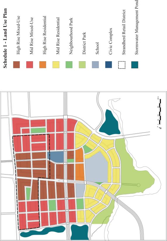
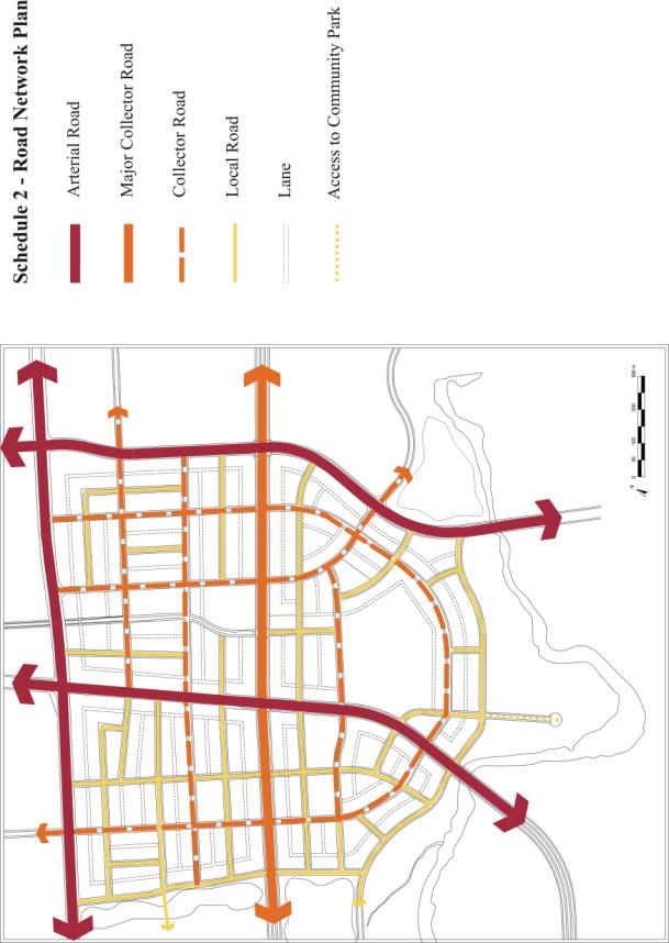
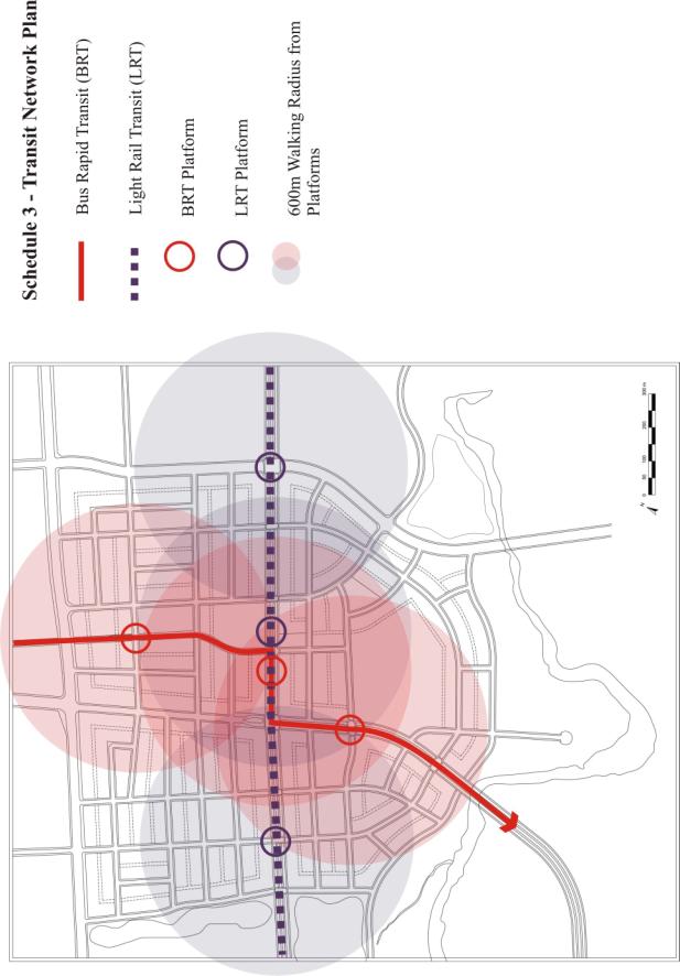
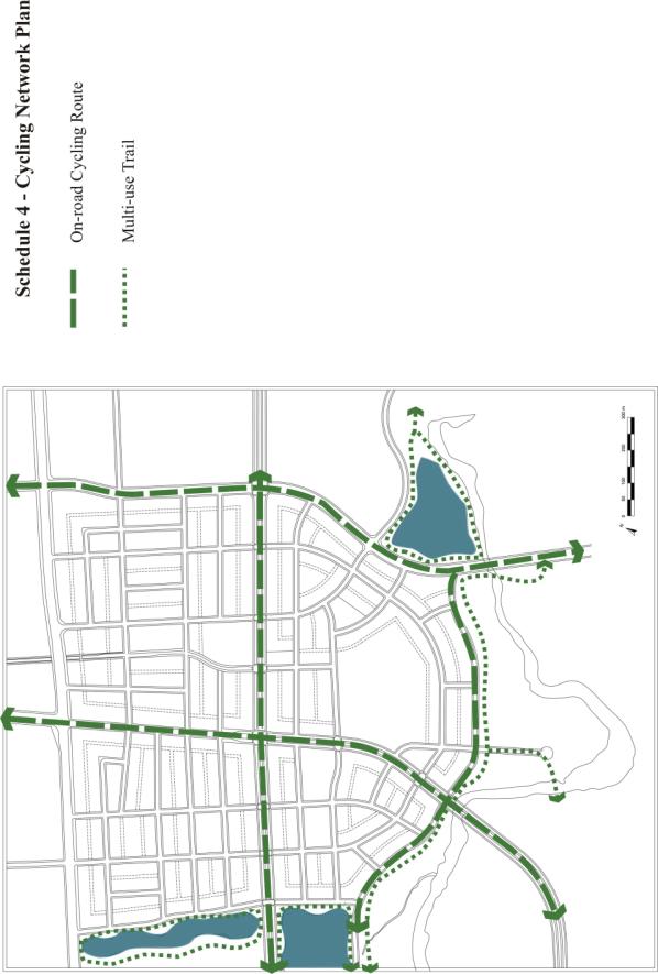
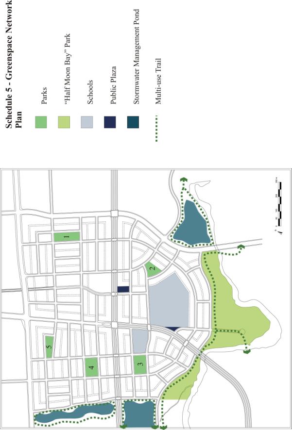
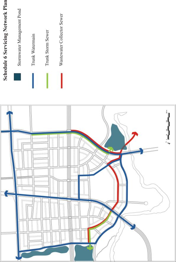
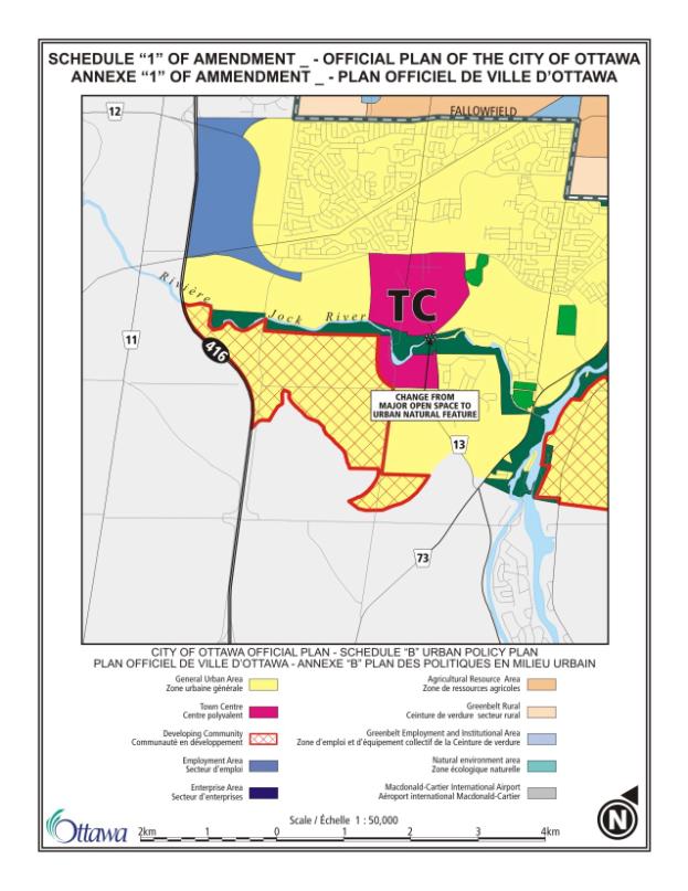
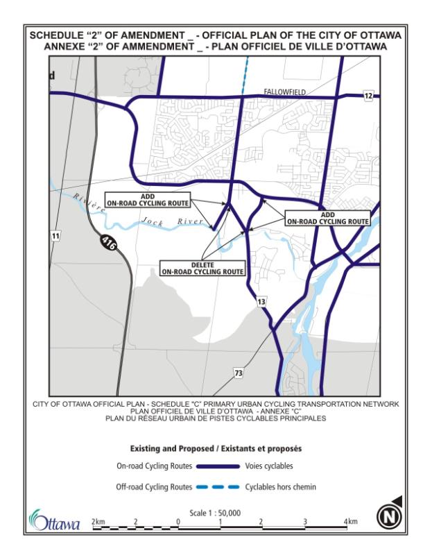
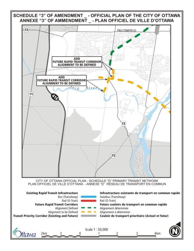
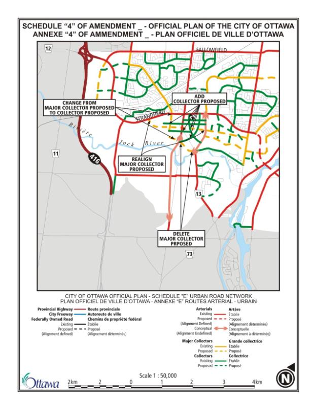
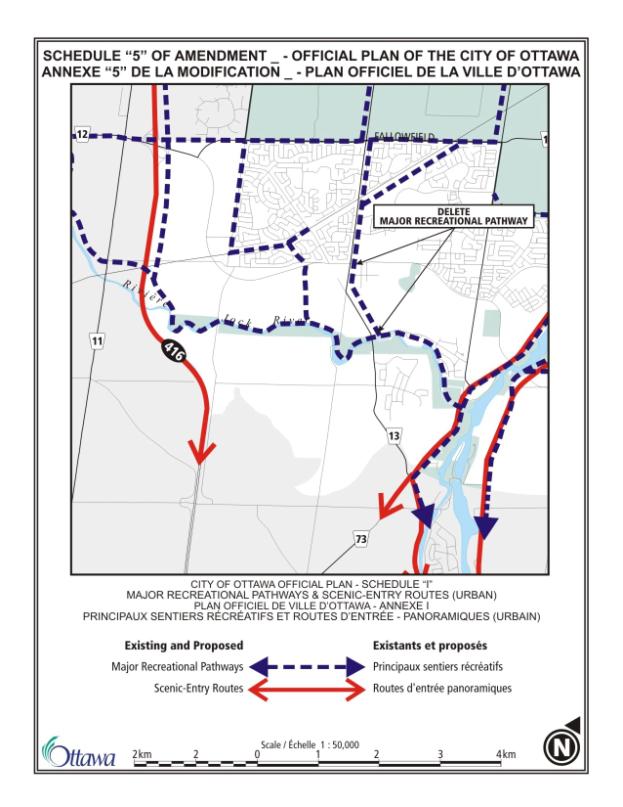
DOCUMENT 6
SUMMARY OF SUBMITTED COMMENTS
Comments from the Public
Comment: The location of the future elementary school on Greenbank
Road may not be an ideal location given traffic, pedestrian safety, and the
surrounding mixed-use context.
Response: The Ottawa-Carleton District School Board has indicated
they are satisfied with the elementary school site as proposed on the west side
of Greenbank Road, provided that the challenges of providing on-site parking,
setbacks, and bus drop-offs can be effectively worked out during the site plan
stage.
Comment: Chapman Mills Drive on the west side of Greenbank Road
should be shifted northwards slightly so that it straddles the two large
parcels equally.
Response: The intent for blocks within the Town Centre is to provide
a pattern of regular development blocks that are approximately 80 metres deep
and between 150 to 200 metres long.
This is based on the Urban Design Strategy’s recommendations that these
sizes are desirable given it provides development blocks that can accommodate a
range of different uses and different forms.
The road and block pattern on the west side of Greenbank Road is
parallel to Strandherd Drive and uses the block depth of 80 metres
consistently, which places Chapman Mills in its proposed location.
Comment: The proposed Greenview Presbyterian Church site at the
northwest corner of the St. Joseph Secondary School site will require safe
access from Greenbank Road both on Sundays and also throughout the week.
Response: The road north of the proposed church site is proposed as
a collector road with a full movement intersection at Greenbank Road. From Greenbank Road, vehicles, pedestrians,
and transit users can easily access the church site.
Comment: The uses listed in 4.1(7)(a), (c) and (d) are currently
permitted according to the current zoning and the Master Site Plan on the site
west of Greenbank Road within the “Strandherd Retail District”, and should
continue to be permitted.
Response: The wording in Section 4.1(7) was revised in the final
version of the CDP to permit the mentioned uses only where allowed by existing
zoning and/or an approved master site plan.
Comment: Section 8.2(4), requiring development approvals by means
of Plans of Subdivision, should not pertain to the “Strandherd Retail District”
until after build-out pursuant to the Master Site Plan.
Response: The wording in Section 8.2(4) was revised in the final
version of the CDP to clarify that Plans of Subdivision would only be required
upon redevelopment of sites within the “Strandherd Retail District”, and would
not be required for future infilling as per approved master site plans and
current zoning.
Comment: Section 8.4(4), addressing the acquisition of Park 5
during any application for redevelopment of the subject lands, should only
apply following build-out, since the subject lands will be required for parking
during this period.
Response: The wording in Section 8.4(4) was revised in the final
version of the CDP to clarify that the acquisition of Park 5 would be during
redevelopment of the sites during the subdivision process identified in Section
8.2(4).
Comment: Will rear lanes be
public or privately owned?
Response: Rear lanes can be either publicly or privately
owned. To note, rear lanes are the
preferred option for the Town Centre but not the only option.
Comments from the
Ottawa-Carleton Catholic School Board
Comment: In the initial community design plan for the Town Centre
in July 2004, the Board was concerned with the proposal to divide Greenbank
Road, as it passed in front of our high school, into two, one-way streets. This issue has now given way to a complete
realignment of Greenbank. Under the
current plan, Greenbank would no longer pass in front of the school and our
main central road access to the facility will be removed. This realignment would result in the need to
redesign the layout of the school grounds, including parking, in/out access,
drop off areas etc., in order to re-establish a central and recognizable “front”
to the school. As noted previously, the
high school was designed at the express request of the City, who were
instrumental in determining the built form of the school and property, to
provide a focus for Greenbank Road.
This request had an impact on every aspect of the school design. It is therefore disconcerting to discover
that in less than three years, the City has completely changed the focus of the
street and by extension the design of St. Joseph HS.
Response: City staff, at the time of writing of this report, are
working with the OCCSB to resolve the issues that have been raised for the St.
Joseph Secondary School site.
Comment: The Board wishes to reiterate that our standard elementary
schools are 1-storey buildings. The
continued insistence on behalf of the City that school boards construct
2-storey schools disregards the Board’s school traditional design that meets
all of our programming, instructional, recreational, transportation and safety
needs.
Response: The Town Centre CDP maintains that all buildings, both
private and public, are to be at least 2 storeys in height. The minimum heights may be higher depending
on the specific area.
Comment: Given our previous experience with St. Joseph High School,
the Board has some concerns with urban design guidelines in general. As noted above, the Board complied with
previous design guidelines only to be left in the current situation where the
design of the school may ultimately be rendered inadequate and require
additional expenditures to modify the exterior design. It is the Board’s opinion that the City’s
urban design guidelines do not adequately reflect the specific demands of
elementary and secondary schools.
Guidelines such as #10 on page 20 that will require setbacks on all
non-residential buildings, including commercial and institutional buildings, be
between 0 and 3.0 metres from any front or side yard property is not
appropriate or realistic for a school facility. We request that school buildings be exempted from these types of
design requirements as they do not take into account the challenges related to
safety, transportation, pedestrians, access, etc., that are specific to a
facility that accommodates in excess of 500 young children every day.
Response: This is a urban
design guideline, and not an urban design policy. The guideline follows the premise that the Town Centre will be an
"urban" community, with a built form, including schools, that is
close to street to strengthen the streetscape.
With that said, there is flexibility in the design guidelines to account
for issues related to specific design issues that a school site might expect to
have.
Comment: The current design includes plans for the extension of the
Southwest Transitway “from the existing Fallowfield Station, arriving in the
Town Centre in a dedicated corridor, traveling west on Chapman Mills Drive in
the dedicated centre median, and then south of Greenbank Road in a dedicated
centre median.” Although the Board
supports the extension of the Southwest Transitway, the inclusion of the
dedicated bus-lane along with a realigned Greenbank Road will increase the
difficulties of accessing St. Joseph High School, in direct contravention of
earlier City-determined plans. Our
initial site plan discussions included consideration for smart growth
principles, where students and others would be walking in a pedestrian-friendly
environment, and the design of the school reflected that. These goals now seem to be contradicted by
the latest plan of pushing a large arterial road across the front of the school
which forms a barrier to access and neighbourhood cohesion. The City must strive to ensure that urban
design and transit plans make the area a pedestrian-friendly environment. As noted in the report, the location of bus
stations will be determined through Environment Assessment Reports. Please be advised that the Board wishes to
be involved in the discussions pertaining to the location of transit stations
that will be in proximity to St. Joseph High School.
Response: One of the community design reasons for shifting the
Southwest Transitway to the medianed lanes of Greenbank Road was to provide a
better seam between neighbourhoods within the Town Centre, insteading of the
divisive effect that the previous dedicated transit corridor had. Greenbank Road will still be designed and
constructed as an "urban" street, although a wider street. There are several proposed full movement
intersections along Greenbank Road, which would facilitate the creation of a
pedestrian friendly environment, particularly where transit is concerned.
Comment: With regard to municipal services, the Board has
implemented temporary services for sanitary, storm and water with the agreement
by the City that that we will ultimately be tied into all new City
services. As such, the Board would appreciate
being kept informed of the City’s progress with regard to the provision of
these new services.
Response: The City can keep
the OCCSB informed of this progress.
Comment: The report indicates that the City will be undertaking a
streetscape master plan. Given our
concerns regarding the street network and access to our school site, the Board
wishes to play an active role during the development of this master plan.
Response: The streetscape master plan will involve all interested
parties, including the OCCSB.
Comment: Please be advised that the approved site plan for the high
school includes a joint use agreement for the development of the proposed
church to the north of the school site.
Included in this agreement is the provision of the east/west road, north
of the church/school site, with access to Greenbank Road. Please be advised that the Board contributed
to the cost of this future road and servicing as part of the cost of the site. This document regarding the City/Board site
purchase agreement should be available from your legal staff. Given the proposed realignment of Greenbank
Road, this east-west road north of the school/church will now become a very
important access point to both the high school and the church property.
Response: The road north of the proposed church site is proposed as
a collector road with a full movement intersection at Greenbank Road. From Greenbank Road, vehicles, pedestrians,
and transit users can easily access the church site.
Comment: With respect to the addition of residential dwelling units
along the southern property line of the high school instead of a road, in
general we do not object to this but consideration in the site plan process was
given to a possible road link to the south.
Until we know how the front of the school will function and how the
access might be handled, we must insist on consideration for a possible access
road as well as the provision of fencing along the property line, at no cost to
the Board.
Response: A road access has
been added along the southern edge of the secondary school site in the final
version of the CDP. The issue of
fencing can be dealt with at the time of the development review process.
Comment: We have also noted a discrepancy between Schedule A1 and
Schedule D. On Schedule A1, the small parcel of land in front of St. Joseph
that has been created as a result of the Greenbank Road realignment is showing
as neighbourhood park. However on
Schedule D – Greenspace, it is identified as a public plaza. The consideration of this parcel is critical
to the functioning of the school, as it relates to our review of options with
respect to how the access, circulation, busing considerations, parking and
other site issues might be accommodated if Greenbank Road is realigned.
Response: "Neighbourhood Park" on Schedule A1 is name of
the land use policy area that applies to both parks and plazas. Both parks and plazas have a different set
of design policies. Schedule D only
shows the difference beween the parks and plazas. The parcel adjacent to Greenbank Road in front of the secondary
school site is a public plaza.
Comment: The City has not indicated how access to St. Joseph High
School will work. We are presently
reviewing options for how this might work and understand that the City’s
Transportation department are also involved.
St. Joseph High School currently has two entrances – one to access the
bus loop and one main access for parking (shared with the adjacent Greenview
Presbyterian Church as per the approved Site Plan). These must be maintained in some form, whether via direct access
to Greenbank, or via a road across the front of the school where the
park/public plaza is shown. We wish to confirm that (a) the City will respect
the significant shift that this entails for the operation of the high school;
and (b) that the City will be responsible for all reasonable costs associated
with modifications necessary to ensure the smooth functioning of access and
egress remediation work required.
Response: City staff, at the time of writing of this report, are
working with the OCCSB to resolve the issues that have been raised for the St.
Joseph Secondary School site.
Comment from the
Ottawa-Carleton District School Board
Comment: Given the unique urban design and intensive land uses
planned for within the Town Centre, it is understood that the Board's
elementary school site will be smaller than the more traditional seven acres
normally required. In combination, the
smaller site size and lack of park frontage may present the Board with
challenges related to on-site parking requirements, setbacks, bus lay-by
location, and other performance standards
Response: These issues can be worked during the site plan approval
process.
Comments from the Ottawa
Forests and Greenspace Advisory Committee
Comment: Section 2.2 Goal 2 High Quality Urban Design: Under
Objectives: (5)
Include more specific reference
to ‘green’ technologies.
Response: The objectives in this CDP are high level, general
statements and noting specific technologies is not warranted here given the
green industry is rapidly evolving, that the plan will be implemented over many
years, and any reference to specific technologies will become dated.
Comment: Section 3.1
Transit: …The Transit centre is located where these two rapid transit routes
intersect… We suggest stating where the transit centre will be located, for
clarification. The revised sketch will also help situate this centre.
Response: Section 3.0 is a high level discussion of the elements
that structure the organization of the Town Centre. It speaks to the location of the transit centre at the
intersection of the two rapid transit routes.
Section 6.1 and Schedule 3 of the CDP illustrate the specific location
of the transit centre in the block pattern.
Comment: Section 3.2 Greenspace: Attention to the Community Park
along length of the Jock River to protect its banks and reduce the potential
for premature erosion. The Pathways should be permeable and should not be
allowed to compromise the environmentally sensitive areas.
Response: This has been added to Section 4.7 of the CDP.
Comment: Section 3.3 Density: …The plan is organized to provide an
“appropriate between”, ADD “appropriate transition between”.
Response: This has been corrected in the final version of the CDP.
Comment: Section 3.4 Streets:
The sketch needs to be revised.
In addition, indicate on the sketch what routes the adjacent neighborhoods
would likely take to directly access the Town Centre. For instance, it is
evident that the existing Barrhaven community north of Strandherd will take
Greenbank Road, as will the future community of South Barrhaven. However, what
route will residents from Hearts Desire, Stonebridge and Manotick take to
quickly reach the Town Centre (Loblaws, Shoppers Drug Mart, Cineplex, Home
Depot…)?
Response: Again, Section 3.0 is a high level discussion of the
elements that structure the organization of the Town Centre. Section 3.4 highlights that Town Centre is
based on an integrated grid pattern of streets, as indicated by the conceptual
sketch. Showing suggested travel routes
from various communities is too detailed for such a sketch.
Comment: Section 4.0: The land …that apply to particular
areas. Do what? Your point is unclear,
needs clarification.
Response: This section has been revised in the final version of the
CDP for clarification purposes.
Comment: Section 4.1 General Land Use Policies: Policies (4); …subject to Policy ( ? ). Permitted Land
Uses, and Min/Max Building Height Tables: Where are these tables?
Response: The missing policy number has been added. These tables were removed from the CDP and
this reference in the text has been removed in the final version of the
CDP.
Comment: Table 2 – Dwelling Type Distribution: The # of dwellings
for both Phase 2 and 3 has increased. Even if the same footprint is used for
residential construction, the intensity has augmented vertically, therefore the
population of the communities is larger.
Have the parkland and greenspaces been increased to match this growth?
Response: The vision for the Town Centre is one of a high density,
compact, urban environment similar in form to that of Ottawa’s downtown and its
surrounding residential areas. In terms
of parkland, this CDP is taking the “standard measures” for parkland dedication
under the Planning Act (5% or 2%) for
all lands within the Town Centre.
Approximately 16% of the land area within the Town Centre will be
parkland. This in addition to the large
areas of District Park adjacent to the south edge of the Town Centre along the
south side of the Jock River and the recreation space associated with two
stormwater management ponds on the east and west edges of the Town Centre. This amount meets the Official Plan targets
for greenspace.
Comment: Table 3 – Land Use Statistics: The Population and
Employment numbers have increased. Have the requirements for the civic
amenities also increased proportionately?
Response: The CDP proposes
a location for a civic complex that can accommodate a range of different civic
uses, both recreational and community uses such as libraries or theatre, once
needs are determined (see Document 6 of this report). This complex is envisioned as multi-storey facility. One secondary school currently exists within
the Town Centre and one elementary school site has been requested. Other community uses, such as places of
worship, are permitted throughout the Town Centre, subject to built form
requirements.
Comment: Section 4.4 Policy Area – High Rise Residential
“Policies (5); At least 90% of required parking for each
development must be provided in parking structures, either above or
below-grade.” This statement should be
revised to state only “below-grade”, as no above parking should be accepted for
high rises.
Response: Above-grade parking structures are permitted to provide
flexibility for the market in terms of design and cost, in order to promote the
development of higher density and higher rise buildings in the Town
Centre. The urban design policies and
urban design guidelines in Section 5.0 speak to the design of above-grade
parking structures, which are based on appropriate models for integrated above
grade parking structures throughout the City.
Comment: Section 4.6 Policy: Under Policies (3): For the
acquisition of Public park, the City should acquire the land before application
for re-development that reflects lower prices of this land.
Response: The majority of the parkland will be acquired through the
planning process, where land is generally taken at the pre-registration value.
Comment: Section 4.6 Policy: Under Policies (4) (d): Be designed
with an emphasis on “hard surfaces and seating…” should be revised to read the following “…emphasis on pathways
with permeable surfaces and seating…” There should not be any hard surfaces
with planted trees. Permeable surfaces should be encouraged throughout the
landscape.
Response: The intensity of pedestrian movement around the trees
will result in compaction of the surrounding soil and stunt growth. Planting the trees in grates is preferred
for their long-term health.
Comment: Section 4.6 Policy: Under Policies (4): Add note (e) “Not
contain active sports fields, which will be concentrated in portions of Half
Moon Bay Park, North of the Jock River, since these will be incorporated into
the South Barrhaven community, South of the Jock River.”
Response: The five public parks within the Town Centre are not
intended to have sports fields like soccer or baseball fields, but have other
active facilities such as tennis courts or basketball courts. A policy was added to Section 4.6 to address
this issue.
Comment: Section 4.6 Policy: Under Policies (5)(d): Be designed
with an emphasis on ‘hard surfaces’ ADD “with permeable surface materials” and
seating…
Response: The intent of this policy is to ensure that parks and
plazas are more “urban” in fashion compared to traditional “suburban” parks, in
order to support the Town Centre’s envisioned built form. This policy does not preclude the use of
permeable surfaces. Such decisions
would be made during the design of each park and plaza on a case-by-case basis.
Comment: Section 4.6 Policy: Under Policies (5)(e): …suburban play
amenities. ADD “suburban play structure amenities”…
Response: “Suburban play structure amenities” are part of the group
of “suburban play amenities”, and thus, no change is required.
Comment: Section 4.7 Policy Area – Community Park: Under Policies
(1): …of this park is preserved. ADD
“However, areas traditionally mowed (grass) will be discouraged and emphasis
placed on preserving some meadows (areas adjacent woodlots and ravines that can
be left natural)”.
Response: 4.7(2)(c) in the CDP speaks to the general intent to
leave the park largely in its natural state.
Natural features and environmental conditions will inform the design of
the park. An Environmental Impact
Statement is required to establish buffers from any natural features within the
site.
Comment: Section 4.7 Policy Area – Community Park: Under Policies
(2) (e): “Parking will be provided in small pods with significant landscaping
treatment” ADD with permeable surfaces.
Response: This has been added to the 4.7(2)(e) in the final version
of the CDP.
Comment:Section 4.7 Policy Area – Community Park: Under Policies
(2) (f): …unless it is demonstrated … We question how will this be done and
accepted?
Response: This will have to be done to the satisfaction of the
City.
Comment: Section 4.7 Policy Area – Community Park: Under Policies
(3): The City…interest groups, ADD and Advisory Committees. (OFGAC).
Response: This has been added to 4.7(3) in the CDP.
Comment:Section 4.9 Policy Area – Civic Complex: Under Policies
(2): …accommodated in structured parking… ADD “underground parking”.
Response: “Structured parking” includes both above-grade parking
and below-grade parking.
Comment: Section 4.9 Policy Area – Civic Complex:
Under Policies (5): ADD a the
timeframe of a 20 year window (short-term) to reach the estimated population
target of Phase 2 (14,544 pop.) as stated in Table 3 Land Use Statistics.
Response: Timeframes are not identified for each of the phases of
development given that all development and re-development within the Town
Centre is dependent on market conditions and interest. Instead the three phases identified in the
CDP speak to three different scenarios of development: Phase 1 - Existing
Development; Phase 2 – Full Development; and Phase 3 – Full Redevelopment.
Comment: Section 4.10 Units Jobs Employment: Provide this section
in the report.
Response: These projections are identified in Tables 2 and 3 in the
final version of the CDP.
Comment: Section 5.0 Urban Design, 5.1 Urban Design Policies
The sketch for Urban Design: At the north-east section of the plan, there
is an existing woodlot. It is situated on the west and south side of the
current retirement home. The parkland shown on the Urban Design Plan should
incorporate this woodlot into its design, perhaps as a tree grove to allow for
passive recreation and respite from the busy commercial/retail area. It also
promotes a pedestrian friendly amenity and provides necessary shade from the
overheated parking lots.
Response: The Urban Design
Demonstration Plan is conceptual in nature and shows how the Town Centre could
develop as per the policies of the CDP.
The incorporation of existing trees would be considered during the
design of each park on a case-by-case basis.
Comment: 5.1 Urban Design Policies: Along the perimeter of the
existing high school, the proposed housing units should not back onto the
sports field, but rather face the yard and support the concept of “eyes on the
park” to keep a visual contact on school property and amenities.
Response: This suggestion would result in the rear lots of these
building facing a public street, which is not desirable from an urban design
perspective in this particular context.
Comment: Guideline 4: To increase the stepping of the building to
promote, even further, a pedestrian friendly street. We recommend revising “For
instance, step the building 2.0 meters above the 4th storey and another 2.0
meters above the 8th storey” to read as follows: “For instance, step the
building 2.0 meters above the 3rd storey and another 2.0 meters above the 6th
storey.”
Response: This is simply an example of the proposed guideline and
is not a policy. While four storeys at
the street before a setback is appropriate in a downtown context, other options
certainly can be considered. Four and
eight storey stepping was identified as desirable in the South Nepean Town
Centre Urban Design Strategy.
Comment: Guideline 11: For the commercial units/buildings add
outdoor patios along with street furniture including planters, shrubs and
trees.
Response: The current general wording within the guideline includes
the suggested uses.
Comment: Guideline 12: What would prevent phantom windows façade similar
to those on the East side of Greenbank and South side of Strandherd, in Riocan
Market-Place, from re-occurring?
Response: 5.1(3) and 5.1(4) provides the policy direction on
building façades and entrances, while Guidelines 12 and 13 provide the guidance
as to how this should be accomplished.
Both urban design policies and urban design guidelines will be part of
the development review process.
Comment: Guideline 16: For street and stacked townhouses, we
recommend to place the parking at the rear and below ground, while providing a
green garage roof, to serve as the unit’s recreational spaces (backyard).
Response: The CDP indicates a preference for rear lane parking,
while allowing other forms that have limited impact on the streetscape. This guideline only speaks to the façade of
garage facing a public street.
Regardless, the option of green garage roofs would be permitted and
encouraged throughout the Town Centre.
Comment: Guideline 17: We recommend adding the requirement of a 3
metre min. radius be included, for allowing soft ground surrounding a tree
planted in this particular type of situation, since it is sandwiched between
the street and building.
Response: Guideline 17 deals with the orientation, access, and
height of ground floor residential uses in taller buildings, and not
landscaping. Guideline 15 speaks to
minimum setbacks for residential buildings and attention to “adequate front
yard landscaping”, which would vary by the type of built form and would be
considered during the development approval process.
Comment: Guideline 22: For Ottawa’s cold winter climate, we
recommend that the floor material of the shelter not be made of concrete, which
allows the cold from the ground to quickly transfer to transit users’ feet. The
floor pads should also be raised for added protection to the cold. In addition,
the shelters should be constructed in such a way as to prevent the harsh cold
wind from penetrating it (especially from below and above the panels). The
opening into the shelter should not be wider than one metre as well, to limit
the cold air from entering. (These comments were sent to the Ottawa Citizen
this winter for the City to reconsider its shelter designs.)
Response: These recommendations are operational and are too
specific to be included in design guidelines.
These recommendations would be considered during the design and
construction of shelters.
Comment: Guideline 23: We recommend adding a minimum radius area
surrounding the trees, to allow these to mature, and adding a minimum distance
to the building’s foundation.
Response: As requirements vary with species selection, they are not
identified in the guidelines.
Comment: Guideline 24: Add same as above comment.
Response: As requirements vary with species selection, they are not
identified in the guidelines.
Comment: Guideline 25: We question whether this really works.
Example Bank Street in the Glebe. We recommend that one tree per number of
units be required, and when the tree cannot be planted due to lack of space,
that the tree be situated within the Neighborhood Park or parkette. In
addition, no cash-in-lieu will be accepted instead of planting the required
amount of trees.
Response: This is a design guideline and not an implementation
policy.
Comment: We do not see anywhere in this report a reference to the
handling of mailboxes. The current practice of placing multiple mailboxes along
a sidewalk on a residential street without further consideration on how these
integrate into the street scape is unsightly and impractical. Discussion and cooperation among the City,
Canada Post and developers is required to create a practical approach in the
placement of these mailboxes within the new communities. Efforts to integrate the mailboxes into the
streetscape, make these areas convenient to use and eliminate the visual
eyesore. Create small sheltered areas
(over and around the mail boxes) and provide a neighborhood bulletin board for
residents use (source: Bois-Franc Montreal).
Response: Mailboxes have been added to Guideline 18 to reflect this
idea.
Comment: Guideline 29: Add the metre unit of measure. And, add the
following note: consisting of coniferous trees for visual screen.
Response: The unit measure has been added. Coniferous trees could
inhibit eye level visibility to the parking areas and reduce security. The specific species would be determined
during the site plan process through a landscape plan.
Comment: Guideline 31: Add “no long rows of continuous parking
spaces”.
Response: This guideline speaks to safe connections through rear
parking areas and not the parking itself, and is not intended to speak to the
orientation of parking spaces.
Comment: Add a “Guideline 34”: Surface for parking lots of (20)
spaces or more, to be of a permeable surface material.
Response: These areas will be paved.
Comment: To complement Guideline 2: Add “Guideline 42” and state
the following: Create plazas and
natural areas by incorporating benches, gazebos or shelters for mail boxes and
include a bulletin board, vegetation and planters, and include lighting at the
pedestrian scale. The purpose of this area is to enhance the pedestrian
environment and create a tranquil/passive gathering place for the immediate
community. This area is not to include play structures (example Bois-Franc, in
Saint-Laurent, Montreal).
Response: The design and amenities for public plazas are identified
in 4.6(5) and does not need to be duplicated in a design guideline.
Comment: Guideline 38: Revise “Ensure that ponds are not entirely
fenced and that any required fencing is decorative in nature” to “Ensure that
ponds are not entirely fenced and that any fencing is purely in a decorative
nature”. The purpose of this revision
is to remove the notion that any fencing would be required at all.
Response: The detailed functional design of stormwater management
ponds will determine the necessity of fencing.
The existing guideline intends that any fencing that is functionally
required for safety purposes will be decorative in nature.
Comment: Also ADD the following to Guideline 38: “Encourage passive
recreation by introducing benches to admire the view and tranquility of the
space”.
Response: This is understood within Guideline 38 and is
specifically contained in Guideline #40, which deals with the trails or
pathways that would surround the stormwater management ponds.
Comment: Section 6.1 Transit: The light rail stations…Chapman Mills
Drive. We recommend that the City show
these on the plan or provide a sketch adjacent to the text.
Response: The proposed LRT and BRT platforms are identified on
Schedule 3 of the CDP.
Comment: Section 6.1 Transit: Also, considerations for introducing
the ever increasing popular “Kiss & Ride” drop off areas in close proximity
to the stations. User convenience increases the use of any transit system.
Response: “Kiss & Ride” drop off areas can be accommodated on
the street, particularly on local streets close to the transit platforms.
Comment: Section 6.2 Road Network: The truck routes should be
identified in the report. Which roads, streets, or promenades will truck
traffic be prohibited? And, which routes will be favored by large delivery
trucks?
Response: This CDP does not speak to truck routes or truck
restrictions, which would be an operation issue. The probable truck routes through the community would be the
arterial roads (Greenbank Road and Longfields Drive), major collector (Chapman
Mills Drive), and collector roads (such as RioCan Drive or Marketplace).
Comment: Section 6.3 Pedestrian and Bicycle System: Policies (1):
It is not necessary to mandate sidewalks on BOTH sides of all streets,
throughout the entire Town Centre. Hard surfaced sidewalks on both sides
unnecessarily widen the roads. Sidewalks are expensive to upkeep and plough in
the winter. Consider a sidewalk on one side only and a form of permeable
pathway on the other side for linkages to the greenspaces.
Response: A sidewalk on both sides of new streets is an existing
policy from the approved Area 7 Secondary Plan for the Town Centre area. The
justification for sidewalks on both sides is based on the higher densities
envisioned for this area, given it is the "downtown" area for South
Nepean. The purely residential area in
the CDP is based on a net density that is approximately 3.5 times greater than
that of a conventional suburban area, while the mixed-use areas in the CDP are
based on a net density that is 6 - 10 times greater than that of a conventional
suburban area. Pedestrian activity will
be much higher in this area given its nature and safe and efficient pedestrian
travel patterns will be more important here than in other conventional suburban
areas.
Comment: Section 6.4 Parking: Policies (5): Cash in lieu of
parking; describe in this Plan that the money will stay in the Community and
will be used to buy parkland, forests and greenspace within the community.
Response: This something that would be addressed in the Parking
Strategy that is intended to be completed following approval of the CDP, as per
Section 8.6. Cash-in-lieu of parking
would likely be used for such purposes of the construction of municipal parking
facilities.
Comment: Section 6.4 Parking: Policies (8): To add reference to the
lighting component of parking areas. ADD “Lighting pollution of parking areas
will be addressed in the parking strategy.”
Response: Lighting would not be covered by a parking strategy,
which would provide specific direction for such elements as on-street parking,
municipal parking facilities, and reductions in parking requirements. Lighting would be addressed through the site
plan process.
Comment: Section 7.3 Utilities: Add a Policy (4): All federal
postal residential mailboxes will be clustered together with no more than X
number in one area, and be fitted with overhead shelter cover and provision for
a bulletin board for the neighborhood residents to use. (There may be a more
appropriate place within the report to put this policy.)
Response: Street amenities, including mailboxes, are covered in
Guideline 18.
Comment: Section 8.3 Phasing: Policy (2)“Proponents must submit an
“Area Concept Plan”:
We recommend adding (f) to the
policy – “an existing natural features plan complete with existing grades (as
in a current “as-is” landscape plan of the site)”. The existing natural features to be shown on the Area Concept
Plan indicating the tree preservation location on plan.
Response: This would be part of the subdivision approval process,
and would not required as part of the “Area Concept Plan”.
Comment: Refer to Strandherd Retail District -- Demonstration Plans
–Phase 3 – Ultimate Build-out: How realistic is this plan, really? In how many
years? What about the existing Big Box Retailers footprint? Do we actually
believe that these companies would give up this footprint? Why is there only
one open area (south of Strandherd and west of Greenbank)? Is this the only
space for greenspace in the entire South Nepean Town Centre Core? What about
adding parkettes throughout the SNTC CDP?
Response: The Demonstration Plan of Phase 3 illustrates the
potential for the ultimate evolution of the SNTC to a future downtown. Phase 3 is a long-term projection, dependent
entirely on the interest of the market to redevelop to higher density
residential or mixed-use uses. The CDP
does not indicate times given it is too difficult to predict. The policies of the CDP permit the existing
sites to remain and further develop as per existing zoning and master site
plans permissions. For future
development and redevelopment, the CDP has policies related to preserving the
identified future public streets and public parks that would permit the
intensification identified by the Phase 3 Demonstration Plan.
Comment: Where the report states: “…The larger sites with big box
stores may redevelop…” , we recommend stronger wording, if this concept has any
chance of really changing towards a pedestrian friendly environment.
Response: The zoning permits the current uses on the site. The City has no power to force redevelopment
of the sites. The anticipation is that
over the long-term, the market changes will determine that redevelopment is
realistic.
Comment: Section 8.5 Greenspace Acquisition: Policy (3): For
parkland dedication, the City will employ the “standard measures” through
Section 51.1 (1) of the Planning Act for all properties within the Town Centre,
and not the “alternative measures” through Section 51.1 (2). We would like the
City of Ottawa to CONFIRM that what this really means, is that the City will
employ 2% for commercial or industrial and 5% for all other cases of the land,
instead of using 1 hectare for each 300 units. Can the City demonstrate the end
result of this proposed policy against the SNTC CDP?
Response: Yes, Section 51.1(1) of the Planning Act will be employed
throughout the Town Centre, meaning 2% for commercial or industrial uses and 5%
in all other cases. The application of
this to the CDP is illustrated in Appendix B of the CDP.
Comment: Section 8.6 Future Initiatives: Add (i) to the Policies: A
Strategy to incorporate mailboxes into the streetscape fabric of the
neighborhood.
Response: Street amenities, including mailboxes, are covered in
Guideline 18.
Comment: Section 8.7 Revision Process: Policy (4): We recognize
that allowances will need to be made to allow the private sector to adapt to
changing market conditions over the longer timeframe for the town centre;
however, we recommend revising Policies (5) as follows: “…on the CDP’s land use
plan. The City will circulate copies of the composite plan to landowners who
are directly affected by the proposed changes for comment, ADD “and to the
surrounding communities of South Barrhaven, Chapman Mills, Hearts Desire,
Stonebridge, Southpointe, Cedarhill and Orchard Estates” If there…
Response: Policies 8.7(3) and (4) refer only to minor revisions,
such as minor variations to local street patterns or changes in block
sizes. These would only affect adjacent
landowners and that is why they are to be circulated. Policy 8.7(5) deals with major revisions that would affect the
broader area, such as major deviations to street patterns or changes in the
applicable land use policy area. These
revisions would require the approval of the Planning and Environment Committee
and would include notification of the above noted communities.
Comment: Section 8.7 Revision Process: Policy (6): As the larger sites
are in close proximity to the natural features and banks of the Jock River,
particularly the area east of Longfields Drive, and south of the realigned
Bren-Maur Road and north of the Jock River, we find that draft Policy (6)
should be revised where it reads “…resulting in land becoming available for
development, such land may be redesignated for urban development without the
need for an Amendment to this Plan, subject to…” to the following sentence,
“…resulting in land becoming available for development, such land may be
redesignated for “open spaces and kept as greenfields and or wetlands”, without
the need for an Amendment to this Plan, subject to…”.
Response: Stormwater management facilities are not contained within
the boundaries of this CDP area and shown throughout the document only for
context. Policy 8.7(6) has been removed
from the CDP.
Comment: Schedule 1 – Land Use Plan: We recommend revising the
maximum for “Med-Rise Residential” Blocks along the “Half-Moon Bay” Parkway to
prevent from obstructing the views and vistas from the South Barrhaven and New
Town Centre Residents, by changing 2-4 storeys high to 1-2 min/max. high.
Response: The Land Use Plan is organized to provide a transition in
height between the higher rise uses closer to Strandherd Drive to the lower
rise uses closer to the Jock River for views from upper storeys of taller
buildings. The road network is
organized to provide as many vistas as possible to “Half Moon Bay” park and the
Jock River along streets. Reducing the
building height maximums to 1-2 storeys would drastically limit the flexibility
of the Mid-Rise Residential policy area, which intends a range of residential
including stacked townhouses and low-rise apartments as well as street
townhouses.
Comment: Schedule 2 – Road Network Plan: While it is evident that
the Barrhaven Community North of the SNTC and the future South Barrhaven
community will use Greenbank Road to access the major retail stores, it is
unclear what route the neighborhoods south of the Jock River could take for
direct access to the same stores. How
does the Hearts Desire, the Stonebridge and Manotick residents directly reach
Loblaws and Home Depot? (Currently Jockvale Road is used and a very short drive
on Greenbank.)
Response: The regular grid pattern of roads permits a multitude of
travel options. The CDP identifies
three full movement intersections from the new Longfields Drive along the
eastern edge of the Town Centre. Once
inside the Town Centre, there are a variety of possible routes to different
areas.
Comment: Schedule 3 – Transit Network Plan: We recommend adding a
“Kiss & Ride” component adjacent the BRT and the LRT platforms.
Response: “Kiss & Ride” drop off areas can be accommodated
on-street, particularly on local streets close to the transit platforms.
Comment: Schedule 4 – Cycling Network Plan: How will the multi-use
trail cross the Jock River?
Response: The multi-use trail could cross at the “old” Greenbank
Road and Longfields Drive’s bridge crossings of the Jock River.
Comment: To preserve the river’s banks and reduce further erosion,
we recommend not to build a path between the Bren-Maur/Jockvale stormwater pond
and the Jock River.
Response: This would be considered during the functional design of
the pond.
Comment: OFGAC requests that an overlay of the aerial view of
existing features be provided and, at the same scale as the SNTC CDP as part of
the report.
Response: This type of information was provided in the “existing
conditions” report for the South Nepean Town Centre Urban Design Strategy
process, and is not required in policy document such as this CDP. Existing features will be considered during
the development review process.
Comment: Add that the existing natural features shall be preserved
and incorporated as part of the greenspace network through such means as
described in the City Official Plan Policies under Section 2.5.4 “A Strategy
for Parks and Leisure Areas”. Also, to
include in the SNTC CDP Report, that pocket parks concept throughout the entire
CDP, commercial, institutional and residential, is required to promote the
pedestrian friendly environment of the community.
Response: Natural features on lands identified as future public
parkland will be considered during the park design process. For other lands, the urban design guidelines
support the preservation of quality, mature trees as part of the development
approval process.
The regular grid pattern of roads
permits a multitude of travel options.
The CDP identifies three full movement intersections from the new
Longfields Drive along the eastern edge of the Town Centre. Once inside the Town Centre, there are a
variety of possible routes to different areas.
Comment: Schedule 3 – Transit Network Plan: We recommend adding a
“Kiss & Ride” component adjacent the BRT and the LRT platforms.
Response: “Kiss & Ride” drop off areas can be accommodated
on-street, particularly on local streets close to the transit platforms.
Comment: Schedule 4 – Cycling Network Plan: How will the multi-use
trail cross the Jock River?
Response: The multi-use trail could cross at the “old” Greenbank
Road and Longfields Drive bridge crossings of the Jock River.
Comment: To preserve the river’s banks and reduce further erosion,
we recommend not to build a path between the Bren-Maur/Jockvale stormwater pond
and the Jock River.
Response: This would be considered during the functional design of
the pond.
Comment: Schedule 5 – Greenspace Network Plan: Park #1 should
include the existing woodlot west/south of the current retirement home on
Strandherd Road.
Response: This would be considered at the park design stage.
Comment: How have the decisions been made to select the plan
location of the four parks shown in Schedule 5?
Response: The parks have been located generally in the different
quadrants of the Town Centre, as per the existing Area 7 Secondary Plan and as
recommended in the South Nepean Town Centre Urban Design Strategy.
Comment: OFGAC requests that an overlay of the aerial view of
existing features be provided and, at the same scale as the SNTC CDP as part of
the report.
Response: This type of information was provided in the “existing
conditions” report for the South Nepean Town Centre Urban Design Strategy
process, and is not required in policy document such as this CDP. Existing features will be considered during
the development review process.
Comment: Add that the existing natural features shall be preserved
and incorporated as part of the greenspace network through such means as
described in the City Official Plan Policies under Section 2.5.4 “A Strategy
for Parks and Leisure Areas”. Also, to
include in the SNTC CDP Report, that pocket parks concept throughout the entire
CDP, commercial, institutional and residential, is required to promote the
pedestrian friendly environment of the community.
Response: Natural features on lands identified as future public
parkland will be considered during the park design process. For other lands, the urban design guidelines
support the preservation of quality, mature trees as part of the development
approval process.
The parks have been located
generally in the different quadrants of the Town Centre, as per the existing
Area 7 Secondary Plan and as recommended in the South Nepean Town Centre Urban
Design Strategy.
Comment: Since the City is increasing residential density
requirements in new developments, how has the parkland dedication been
increased proportionately?
Response: As per the above comment on greenspace and higher
densities.
Comment: OFGAC requests that an overlay of the aerial view of
existing features be provided and, at the same scale as the SNTC CDP as part of
the report.
Response: This type of information was provided in the “existing
conditions” report for the South Nepean Town Centre Urban Design Strategy
process, and is not required in policy document such as this CDP. Existing features will be considered during
the development review process.
Comment: Add that the existing natural features shall be preserved
and incorporated as part of the greenspace network through such means as
described in the City Official Plan Policies under Section 2.5.4 “A Strategy
for Parks and Leisure Areas”. Also, to
include in the SNTC CDP Report, that pocket parks concept throughout the entire
CDP, commercial, institutional and residential, is required to promote the
pedestrian friendly environment of the community.
Response: Natural features on lands identified as future public
parkland will be considered during the park design process. For other lands, the urban design guidelines
support the preservation of quality, mature trees as part of the development
approval process.
DOCUMENT 7
CIVIC FACILITIES
Civic Complex
The City of Ottawa's Recreation Infrastructure
Strategy and Project Listing includes a new recreation complex in southeast
Nepean to service growth. The time
horizon for implementation will be dependent on growth patterns and the
availability of funding in the Long Range Financial Plan. This complex is not likely to be funded for
construction until at least 2011.
Within the CDP, this complex is intended to be a “civic complex” with a
range of uses including recreation uses.
A site is planned for the civic complex at the transit centre of the
Town Centre, adjacent to both the LRT and BRT routes through the Town Centre.
Fire
Ottawa Fire Service is presently undertaking a
detailed fire station location study in the suburban area and growth areas of
the City, including the South Nepean area. Once this study is complete, which
is anticipated to be December 2006, Ottawa Fire Service will be in a position
to indicate where an additional station in the South Nepean area will be
located, if one is required. Within the
CDP, a Fire Service facility is permitted on all lands within the Town Centre,
subject to built form requirements, and could be accommodated within the civic
complex identified above.
Police
Ottawa Police Services does not anticipate the need
for a major facility within the South Nepean Town Centre. However, Ottawa
Police Service may require a future Community Police Centre that is housed
within a civic facility. Within the
CDP, a Police Service facility is permitted on all lands within the Town
Centre, subject to built form requirements, and could be accommodated within
the civic complex identified above.
Paramedic
The Ottawa Paramedic Service is currently located at
the Nepean Fire Hall on Greenbank Road. and has made a request for a site on
the City lands on Longfields Drive to re-locate this Paramedic Post. This new site would serve all the residents
of South Nepean, including the Town Centre and, therefore, a site within the
Town Centre is not required. Within the
CDP, a Paramedic Post is permitted on all lands within the Town Centre, subject
to the built form requirements, and could be accommodated within the civic
complex identified above.
Library
The Ottawa Public Library are currently undertaking
a Facility Growth Planning Study regarding future library facilities related to
growth over the next twenty years. The Ottawa Public Library will be able to
identify library needs in these areas of the City once this Study is
completed. Within the CDP, a library is
a permitted use within the Town Centre, subject to built form requirements, and
could be accommodated within the civic complex identified above.
Client Service Centre
The Client Services and Public Information Branch of
the Corporate Services Department does not foresee any additional requirements
within the South Nepean Town Centre.
Within the CDP, a Client Service Centre is a permitted use within the Town
Centre, subject to built form requirements.
A Client Service Centre could be accommodated within the civic complex
identified above.