1. OFFICIAL PLAN AMENDMENT - 375 MACLARENS SIDE ROAD
PLAN OFFICIEL - 375, CHEMIN SECONDAIRE
MACLARENS
|
COMMITTEE RECOMMENDATION
AS AMENDED
That Council approve an amendment to the
Official Plan of the former Township of West Carleton to change the land use
designation of 375 MacLarens Side Road from Agriculture Resource to General
Rural Area as shown in Document 1.
Recommandation MODIFIÉE du comitÉ
Que le Conseil municipal approuve
une modification au Plan officiel de l'ancien Canton de West Carleton qui
aurait pour effet de faire passer la désignation de la propriété située au 375,
chemin secondaire MacLarens de Zone de ressources agricoles à Zone rurale
générale.
Documentation
1.
A/Deputy
City Manager, Planning and Growth
Management report dated 28 June 2006 (ACS2006-PGM-APR-0018).
2. Extract of Draft Minutes 31,
Agriculture and Rural Affairs Committee meeting of August 24, 2006.
Report
to/Rapport au :
Agriculture and Rural Affairs Committee
Comité d'agriculture et des questions rurales
and Council / et au Conseil
28 June 2006 / le 28 juin 2006
Submitted by/Soumis par John L. Moser,
Acting Deputy City Manager/Directeur municipal adjoint par intérim,
Planning
and Growth Management / Urbanisme et Gestion de la croissance
Contact
Person/Personne Ressource : Grant Lindsay, Manager / Gestionnaire,
Development Approvals / Approbation des demandes d'aménagement
(613) 580‑2424, x13242 Grant.Lindsay@ottawa.ca
|
|
Ref N°: ACS2006-PGM-APR-0018
|
|
SUBJECT:
|
OFFICIAL PLAN - 375 MacLarens Side
Road (fILE NO. D01-01-05-0010)
|
|
|
|
|
OBJET :
|
PLAN OFFICIEL -
375, chemin secondaire maclarens
|
REPORT RECOMMENDATION
That the recommend Council refuse an amendment to the Official Plan of
the former Township of West Carleton to change the land use designation of 375 MacLarens Side Road from Agriculture
Resource to General Rural Area as shown in Document 1.
RECOMMANDATION DU RAPPORT
Que le Comité de l'agriculture et des questions
rurales recommande au Conseil de refuser d'apporter une modification au Plan
officiel de l'ancien Canton de West Carleton qui aurait pour effet de faire
passer la désignation de la propriété située au 375, chemin secondaire
MacLarens de Zone de ressources agricoles à Zone rurale générale.
BACKGROUND
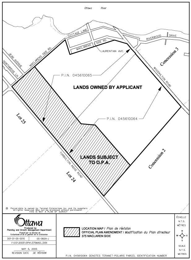
The lands at 375 MacLarens Side
Road are bounded by MacLarens Side Road to the north, on the west by Torbolton
Ridge Road, on the east by Woodkilton Road and to the south by a mix of active
farmlands and woodlots (see Document 1).
A mix of permanent and cottage type residential units can also be found
along the north side of MacLarens Side Road and along portions of the east side
of Woodkilton Road.
The subject property consists of
a mix of woodlots, stream courses, rock outcrops and agricultural land
uses. The western edge of the subject
lands along Torbolton Ridge Road represent the highest elevation of the
property. At this elevation the lands
are comprised of wooded pasture and two, separated, cropped fields. This upper portion of the subject lands ends
abruptly at a steep drop (escarpment) into an open area, which is used as an
unimproved pasture.
The applicant’s total land
holding comprises an area of approximately 113.2 hectares. Current land uses on the property represent
a mix of woodlots and agricultural land uses.
In March of 2005 the property
owner of 375 MacLarens Side Road and his consultant met with City staff to
review the submission requirements for an Official Plan Amendment. A proposal was outlined to redesignate a
portion of the subject lands from agriculture to a designation that would
support a future country estate lot development.
Shortly after meeting with City
staff the owner’s consultant submitted a request to amend the City’s Official
Plan from “Agricultural Resource Area to General Rural Area”. Accompanying the application was a Planning
Rationale Report and a Soil Survey and Canada Land Inventory Classification
Report.
DISCUSSION
The lands are designated
“Agricultural Resource Area” in the City Council Approved Official Plan and in
the former Region of Ottawa-Carleton Official Plan and the Township of West
Carleton Official Plan. The owner has
indicated that a plan of subdivision and Zoning By-law amendment for the lands
will be submitted to the City should the Official Plan Amendment be approved. The applicant proposes to redesignate
approximately 40.7 hectares of the 113.2 hectares from “Agricultural
Resource to General Rural Area”.
The City Council Approved
Official Plan set out criteria that must be satisfied when considering
amendments to the Official Plan. In
addition, amendments to an Official Plan shall be consistent with the
Provincial Policy Statements. These
criteria are provided below.
Section 5.2.2 of the City Council
Approved Official Plan states;
1. When
considering amendments to this Plan, the City will have regard to, among other
things, the following criteria:
a) The
impact of the proposed change on the achievement of the policies expressed in
this Plan;
b) The
effect of the proposed change on neighbouring communities;
c) The
effect of the proposed change on the need for water, wastewater and
transportation services;
2. When
considering amendments that affect the use of a specific site or sites, the
City will also consider whether there is a need to add the site or sites to the
lands already designated for the proposed use.
The Provincial Policy Statement
(PPS) states:
“Prime
agricultural areas shall be protected for long-term use for agriculture. Prime
agricultural areas are areas where prime agricultural lands predominate. Specialty crop areas shall be given the
highest priority for protection, followed by Classes 1, 2 and 3 soils, in this
order of priority.” Document 3 explains
in greater detail the applicable Provincial Policy when considering an Official
Plan amendment.
The supporting documentation to
this application clearly identifies the variety of soil conditions on the lands
subject to this amendment. The City
Council Approved Official Plan and the Provincial Policy Statement (PPS)
considers Class 1-3 soils as prime agricultural areas. Of the total land holding (113.2 hectares),
70.2% is with in the range of what is considered the top three soil categories
(Class 1 – 3).
When calculating the area subject
of the amendment (40.7 hectares) 57.6% of the lands fall within the top three
soil categories, with the majority of these lands having a Class 3 rating. The Soil Survey Report also notes that the
soil units in the amendment area do not form a contiguous unit of Class 3
soils. These soil units are comprised
of complex soil units and small units of pure Class 3 soils. Escarpment features and the eroded stream
channels effectively limit the production of mechanized agriculture. Further, the consultant notes that the lands
on the upper part of the escarpment do not represent a pure soil unit, and are
considered to be in a combined soil classification due to the undulating nature
of the underlying bedrock. Given the
combined class of soils an alternative method of assessment, known as the
Hoffman Indices has been applied. The
alternative method, which is an accepted practice by the Ontario Ministry of
Agriculture, reduces the overall average of 57.6% of Class 1 –3 to about 25 %.
The applicant has demonstrated
that the soils on the lands subject to the proposed amendment are not of a high
agricultural value; however, the value of agricultural land is not determined
by soils alone. The autonomy and
operational ease of adjacent lands are impacted by the proposed development and
this must be factored into staff’s recommendation rationale. Agricultural land as defined by the PPS is
predominate in this area. The amendment
lands represent the northerly most section of a large tract of agricultural
land. The same argument being put
forward to rationalize this Official Plan Amendment is the argument that could
be used to further redesignate the remaining agricultural parcel in the future.
The MacLarens Landing development
has existed for a number of years in harmony with the adjacent lands. The expectations of residents of a new
development may be quite different than those of the cottage-residential
development in MacLarens Landing.
The applicant has provided
information based on the Minimum Distance Separation (MDS) which has been
calculated for the existing barns on and adjacent to the subject lands. Only one barn (main barn) has been
identified as a possible impact on the amendment lands. The Report does not address the issue of
impacts and what limitations will be imposed on the remaining farm parcel
should the operation change or expand in the future.
Further, the application has not
demonstrated a need for additional land to be designated to accommodate the
creation of residential estate lots as required by the Provincial Policy
Statement. According to the City of
Ottawa Draft Rural Residential Land Survey (2004-2005 update) there is
potential for 5,433 vacant residential lots in the West Carleton Ward. This amount is derived by adding together
the unit potential on lands currently designated for residential and the
current development applications before the City, i.e. pending, draft approved
and registered plans of subdivisions.
This application does not satisfy
the tests as outlined in the City Council Approved Official Plan and the
Provincial Policy Statement, and therefore, the Department recommends the
refusal of this application.
RURAL IMPLICATIONS
Approval of the amendment will impact on the viability
of agriculture on the subject lands and in the immediate agricultural
community.
CONSULTATION
Notice
of this application was carried out in accordance with the City's Public
Notification and Consultation Policy. The
Ward Councillor is aware of this application and the staff recommendation.
Detailed
responses to the notification/circulation are provided in Document 2.
FINANCIAL IMPLICATIONS
N/A
APPLICATION PROCESS TIMELINE
STATUS
This
application was not processed by the "On Time Decision Date"
established for the processing of Official Plan amendments due to the
complexity of the issues associated with the the information provided in
support of the application in additon to a request to have the application put
on hold by the owner.
SUPPORTING
DOCUMENTATION
Document 1 Location
Map
Document 2 Consultation Details
Document 3 Provincial Policy Statement Details
DISPOSITION
Corporate Services Department, City Clerk’s
Branch, Secretariat Services to notify the owner, Jack MacLaren, 114 Creekside
Drive, Woodlawn, ON K0A 3M0, applicant,
McIntosh Perry Consulting Engineers Ltd., 115 Walgreen Road, Carp, ON K0A 1L0, Signs.ca, 866 Campbell Avenue,
Ottawa, ON, K2A 2C5, Ghislain Lamarche, Program Manager, Assessment, Financial
Services Branch (Mail Code: 26-76) of
City Council’s decision.
LOCATION MAP DOCUMENT
1
CONSULTATION DETAILS DOCUMENT
2
This application was subject to the
Public Notification and Consultation Policy.
PUBLIC
COMMENTS
Resident of Maclarens Landing
does not want a plan of subdivision. It
is a rural community with dirt roads.
We do not want our community to be affected by a subdivision at this
location.
COUNCILLOR’S COMMENTS
Councillor Eli El-Chantiry is
aware of the application
COMMUNITY ORGANIZATION COMMENTS
MacLaren Community Association
has some concerns. Would like to be kept
abreast of any meetings and approvals.
ADVISORY COMMITTEE COMMENTS
Ottawa Forests and Greenspace Advisory
Committee
This is an application to change a 40.7 ha
parcel of land designated as Agricultural Resource Area in the Official Plan to
General Rural. The site, located close
to but not bordering the Ottawa River, is not within a village, as defined in
the Official Plan. Approximately 1/3 of the MacLaren holding between Torbolton
Ridge Road and Woodkilton Road is proposed for re-designation. All or part of the entire land holding is
currently farmed.
The applicant has provided soils survey data to
show that the land is not good agriculture land although it is being actively
farmed.
The Ottawa Forests and Greenspace Advisory
Committee opposes the re-designation of this land on the following
principles/for the following reasons:
- Rural
residential development does not conform to the Official Plan intent to
intensify within the urban boundary.
- As
shown in the Rural Residential Vacant Land Survey 2003 Report – ACS2005-PGM-POL-0041) presented to
Planning and Environment on June 28, 2005, there are 18,691.75 ha
comprising 26,850 units of vacant land available for development outside
the Urban Boundary. 6,558 of those
units (24% of the City’s available supply) are in West Carleton, so there
is no shortage of rural land available for development. There is no need for this
re-designation
- Additional
rural development so far from the core will put pressure on the City to
provide services, will increase vehicular traffic on roads in an area not
served by public transit, and will increase the strain on the groundwater
supply and require additional septic services.
- Although
the land proposed for re-designation is said to be largely of low quality,
the CLI classes are given for the entire site, not for the land that is
proposed for an Official Plan Amendment.
- The
land is designated Agricultural Resource, a category of land that is to be
protected from development.
- Some
of the land proposed for re-designation is wooded (described as wooded
pasture land in the consultants report) and removal of that forest will
further erode the city’s ability to meet its 30% forest cover target as
outlined in the OP
PROVINCIAL POLICY
STATEMENT DETAILS DOCUMENT
3
2.3.3 Permitted Uses
2.3.3.1 In prime agricultural
areas, permitted uses and activities are: agricultural uses, secondary uses and agriculture-related uses. Proposed new secondary uses and agriculture-related
uses shall be compatible with, and shall not hinder, surrounding
agricultural operations. These uses shall be limited in scale, and criteria for
these uses shall be included in municipal planning documents as recommended by
the Province, or based on municipal approaches which achieve the same
objective.
2.3.3.2 In prime agricultural areas,
all types, sizes and intensities of agricultural
uses and normal farm practices
shall be promoted and protected in accordance with provincial standards.
2.3.3.3 New land uses, including the creation of lots, and new or
expanding livestock facilities shall comply with the minimum distance separation formulae.
2.3.4.3 The creation of new residential lots in prime agricultural areas shall not be
permitted, except in accordance with policy 2.3.4.1(c).
2.3.5 Removal of Land from Prime Agricultural Areas
2.3.5.1 Planning authorities may only exclude land from prime agricultural areas for:
a)
expansions
of or identification of settlement areas
in accordance with policy 1.1.3.9;
b)
extraction
of minerals, petroleum resources and mineral aggregate resources, in
accordance with policies 2.4 and 2.5; and
c)
limited
non-residential uses, provided that:
- the land
does not comprise a specialty crop
area;
- there is a
demonstrated need within the planning horizon provided for in policy
1.1.2 for additional land to be designated to accommodate the proposed
use;
- there are no
reasonable alternative locations which avoid prime agricultural areas; and
- there are no reasonable alternative
locations in prime agricultural areas
with lower priority agricultural lands.
2.3.5.2 Impacts from any new or expanding non-agricultural uses on
surrounding agricultural operations and lands should be mitigated to the extent
feasible.
The Provincial Policy Statement
defines Prime Agricultural Areas as:
areas where prime agricultural lands predominate. This includes:
areas of prime agricultural lands and associated Canada Land Inventory Class
4-7 soils; and additional areas where there is a local concentration of farms
which exhibit characteristics of ongoing agriculture. Prime agricultural areas
may be identified by the Ontario Ministry of Agriculture and Food using
evaluation procedures established by the Province as amended from time to time,
or may also be identified through an alternative agricultural land evaluation
system approved by the Province.
OFFICIAL PLAN AMENDMENT - 375 MACLARENS SIDE
ROAD
PLAN OFFICIEL - 375, ROUTE SECONDAIRE
MACLAREN
Mr. J. Ostafichuk, Planner,
Planning and Growth Management, provided a detailed presentation in which he
reviewed the details of the above-noted application and the staff
recommendation on same. A copy of his
presentation is held on file.
Mr. M.
Snider, Planning Consultant, McIntosh and Perry Consulting, spoke on behalf of the
applicant. He described the subject
property’s geographical location, noting the presence of a number of
residential dwellings and cottages in the area currently just to the North of
the property. He showed photographs of
the property so that Committee members could appreciate its size, surrounding
area and topography. He indicated the
applicant’s property was 283 acres in total, with the subject land encompassing
41 hectares of that. The eastern
portion of the site is quite a high escarpment, approximately one hundred feet
high, with the toe of the slope defined as boulder pavement. He described the land as rocky, with stony
areas and rocks projecting through the soil surface. He noted that a wooded area defined the portion of the property
that historically had not been good farmland.
Mr. Snider discussed the soil
testing and acknowledged that 27% of the subject lands were classified as class
3. However, he maintained that these
lands were fragmented, stony, and poorly accessible because they were broken-up
by deep stream valleys, wooded ridges and other obstructions. Therefore, although a small portion of the
property may be class 3 soil, it is very difficult to farm because it is
difficult to access with farm machinery.
He noted the property owner proposed to maintain transitional lands
between the OPA lands and the portion of his property that would continue to be
used as croplands. He then showed
Committee a layout of the concept plan for a proposed country lot residential
development. This area would be
separated from the cropland areas with stream valleys, which would be protected
in their natural state and held in common.
Mr. Snider discussed the Provincial Policy Statement, noting the critical
thing was whether or not these lands should be considered part of the prime
agricultural area. He opined that they
should not be. He maintained this
portion of the property was at the northern extent of the prime agricultural
area and represented a narrow finger.
He referenced the residential uses currently to the North and to the
West, in an area currently designated as rural natural feature lands, and
maintained the applicant was looking to extend that boundary to the toe of the
escarpment slope. He felt the subject
lands were more akin to the lands to the West and to the North and less so to
the agricultural area and he felt there was sufficient justification to approve
the application. With respect to
whether or not this form of development would have an impact on the
agricultural land, Mr. Snider believed that with careful design, any potential
impacts could be mitigated; by the proposed buffering and by the fact that
there was a clear division in the natural features between the two areas. Furthermore, he noted there were all kinds
of tools and mechanisms that could be applied through the subdivision approval
process to ensure that conflicts were minimized. In closing, Mr. Snider stated that the applicant intended to
continue to farm his land and that the issue of protecting farmland through the
PPS was not in dispute. He expressed
the applicant’s intent to maintain a good portion of farmland as it had always
been.
Councillor El-Chantiry
referenced several of the lots in the proposed country estate lot subdivision,
noting these had previously been planted in corn. Mr. Snider confirmed that the land had previously been planted in
corn. However, he maintained these
fields were only 6 or 7 acres and they were removed from the remainder of the
farmland. Furthermore, the escarpment
between these fields and the remainder of the farmland made them difficult to
access. With respect to the soil, he
indicated there was a complex arrangement of soil types in those fields. For that reason, a different soil assessment
was conducted, resulting in a class 4.
Therefore, those fields were not considered prime soils.
Responding to a further
question from Councillor El-Chantiry, Mr. Snider indicated that in general,
soils in the Kinburn area were considered class 1 to 3. However, he re-iterated that only a small
portion of the subject lands were considered class 3 and these were stony and
fragmented by the ridge, wooded areas and a stream. Therefore, the soil study concluded these lands were
marginal.
Chair Jellett asked the speaker to address
concerns with respect to the Minimum Distance Separation (MDS) calculations
from the barns to the proposed development, as referenced in the staff
report. Mr. Snider identified the
barn’s location on a map of the property.
He noted the MDS separation distance is based on the worst-case
scenario, 150 cattle. He indicated the
barn currently housed 50 cattle.
Furthermore, he maintained these were croplands; this was not a cattle
operation nor were there any plans to expand the current cattle operation. Mr. Snider noted that within the minimum
allowable distance, there currently were 15 houses. He submitted the MDS guidelines say that if you have a number of
other conflicting uses within the allowable distance, they can be discounted
entirely. Also, he noted that in this
area, the buffer was a little wider and he maintained there was plenty of
separation between the livestock facility and any proposed residential
development.
Chair Jellett referenced the staff
presentation and the contention that the application did not demonstrated the
need for additional land to be redesignated to accommodate residential estate
lots. Mr. Snider posited that these
lands could be removed from the prime agricultural area. If they were removed, other Provincial
Policy Statement policies would apply.
These would allow for limited residential development in the rural
area. He re-iterated that because the
lands to the West, the North and the Northwest were outside the prime
agricultural area and because of the nature of the subject property, he felt
there was justification for removing it from the prime agricultural area. That being said, he referenced the number of
available lots in West Carleton and submitted that the number seemed high. He suggested that those numbers included
pending plans of subdivision, draft approved plans of subdivision and the
existing vacant land inventory. He
submitted many of those lands had been sitting on the books for years going
nowhere because they were on the Carp Ridge; they were void of trees and they
had hydro-geological problems.
Therefore, he argued that the supply of available lots in West Carleton
was not as high as had been suggested.
Mr.
R. Fraser, Chair of Rural Issues Advisory Committee, referenced a motion
approved by the RIAC, which suggested that in areas where the prime
agricultural designation was marginal, staff should be open to re-assessing the
designation. He indicated he had
visited MacLaren’s Landing and that, as a farmer, he had difficulty finding
what he would describe as significant areas of prime agricultural land. He acknowledged that there were pockets of
it, but that there was also a considerable amount of rough land. He submitted that based on today’s
agricultural economy, the subject property could not be considered a large
tract of prime agricultural land. With
respect to any potential expansion of the livestock operation on the property,
again, he felt there was not enough prime agricultural land to justify anyone
ever considering establishing an intensive livestock operation. Therefore, he felt that should not be a
consideration.
With
respect to the possibility of future intensification of livestock, Councillor
El-Chantiry wondered if there was any ability to impose mitigating conditions
in the future, when the plan of subdivision would come forward for approval. Mr. G. Lindsay, Manager of Development
Approvals, responded in the negative.
He explained that the Ministry of Agriculture and Food prescribed
separation distances and whatever distance was prescribed by the Ministry, that
area would be excluded from any draft plan approval of subdivision.
Responding to a further question from
Councillor El-Chantiry, Mr. Lindsay indicated that, should a plan of
subdivision come forward as had been depicted by the applicant and the Ministry
prescribed a minimum distance of 300 metres or 600 metres, then any lots
contained within that perimeter would have to be removed from the plan of
subdivision.
Chair Jellett inquired as to
the ramifications if Committee disagreed with the staff recommendation. Mr. Lindsay indicated it was difficult to
speculate. However, he outlined the
potential impacts as follows:
·
It
would weaken the Policy and the Official Plan.
Staff was implementing a Council-approved Official Plan, which had gone
through a full and complete public process.
The line was drawn and to incrementally piece it off on the edges would
only serve for other applications to follow.
·
Should
the staff recommendation not be approved, the Province may step in and refer
the matter to the Ontario Municipal Board.
The City would then be faced with a situation where staff would not be
representing Council’s position at the OMB.
In fact, staff would be subpoenaed to appear against Council. Such situations should be avoided if at all
possible.
In closing, Mr. Lindsay
submitted that in essence, what Committee faced was a decision as to whether or
not it would support the policies contained in the Council-approved Official
Plan. Should the staff recommendation
carry and the applicant appeal Council’s decision to the OMB, that would be a
different matter because the applicant would have an opportunity to prove his
case at the Board and staff would represent Council’s position.
Responding to a further
comment from Chair Jellett, Mr. Lindsay reminded Committee that the Official
Plan had gone through a significant amount of public consultation and the City
was required to review it every 5 years.
He submitted that would be the time to consider this proposal; when all
of the boundary would be examined and the various factors would be taken into consideration. He stated that as more and more developments
of this nature occurred, there was more and more strain on municipal services
and the City had to respond; reducing speed limits, increasing garbage pick-up,
etc. He maintained it had been proven
that this type of development cost the City more than it generated in
revenue. Therefore, the City had to
come to grips with the amount of development of this nature it would continue
to allow in rural areas before the rural areas were no longer rural. These issues have to be balanced off and
this is what the next review of the Official Plan will be looking at; how much
of this type of development can be sustained, where it should occur, and should
the agricultural designation be reduced to allow it to occur. He did not believe the City should be
approving such applications on a one-off basis. He felt it sent the wrong message to the rural area, that people
would be bringing forward applications and arguing their farmland was not
economically sustainable, and that cumulatively it would create a problem. He maintained it was best addressed during
the 5-year review of the Official Plan.
Chair Jellett wondered what
the City would say then, to farmers whose land could not be farmed properly in
today’s farm reality; that their farm was worthless and they would not be
allowed to develop it or use it for anything else. Mr. Lindsay maintained that because land could not be farmed did
not mean it was automatically available for development. He submitted that the cumulative impact of
this type of development had to be assessed by the City in terms of whether or
not the City could afford to sustain it.
He suggested what he would say to an individual whose farmland was
perhaps no longer agriculturally viable was that he or she would have to wait
until Council made a decision, in conjunction with the Province, as to the
impacts of this type of development and the need for it. He questioned the need for 30 more estate lots
in West Carleton when there was a 65-year supply of developable land in that
area. Furthermore, he questioned the
wisdom of creating a potential source of conflict through the MDS formula,
noting the adjacent community of MacLaren’s Landing had already expressed some
concerns over the proposed development.
Chair Jellett felt the first
part of Mr. Lindsay’s response had touched on the issue of property rights; an
issue that had recently generated a significant amount of debate. Mr. Morrison, Director of Planning and Infrastructure
Approvals, submitted this touched on a dilemma faced by landowners and the
City. He invited Mr. Marc to comment on
a recent occurrence with respect to the issue of the availability of rural
estate lots.
Mr. Marc, Manager of Planning
and Environment Law, recalled a recent matter before Committee with respect to
proposed development in Dunrobin. He
advised that although in the Dunrobin case, the City’s lead argument was based
on hydro-geological concerns, the OMB hearing was actually won on the question
of need. Staff was able to satisfy the
Board that there were enough lots available in West Carleton.
Responding to a question from
Councillor El Chantiry, Mr. Lindsay indicated the next review of the Official
Plan was scheduled for 2008, at which time all of the policies contained in the
OP would be reviewed.
Councillor Brooks argued many of the policies the City had to deal with
were driven by Toronto and by jurisdictions in other parts of the
Province. He felt it was time the City
of Ottawa took a role in challenging some of those policies that did not work
in Eastern Ontario and he suggested City staff tended to back away from such
challenges. He discussed the scope and
challenges of modern day farming. He
referenced the pictures Mr. Snider had shown of the subject property and argued
what he saw was not prime agricultural land because of the boulders, stumps,
streams and other barriers to farm machinery.
He talked about the dwindling number of farms in Ontario, the economics
of farming, and the issue of property rights.
With respect to the issue of availability of and need for development
land, the Councillor argued that this country was built on entrepreneurship and
capitalism. He suggested this property
owner was being entrepreneurial and seizing an opportunity to develop his
land. By doing so, he would create jobs
and put money into the economy. Having
spoken with the applicant, he felt there was community support for the proposal
and he maintained that communities should be allowed to govern themselves. He believed the City had to be flexible in
interpreting and applying the Official Plan and the Provincial Policy
Statement. Speaking to the argument
that development of this nature would put pressure on the City’s
infrastructure, he argued development charges were intended to alleviate that
pressure. Furthermore, he submitted
that growth in rural areas was being impeded by such arguments and unless more
development was allowed in rural areas, the gap between the urban and suburban
Councillors would continue to increase.
In closing, Councillor Brooks urged Committee members to vote down the
staff recommendation and to support the Official Plan Amendment application.
Councillor Thompson spoke in support of country estate lot development,
noting that more and more, people were moving to the rural areas because they
wanted that additional space.
Furthermore, he felt property owners should have the right to develop
their land as they saw fit, within reason.
He maintained that rural planning issues had been re-assigned to the
ARAC instead of the Planning and Environment Committee because there was
recognition that these should be treated differently. He acknowledged staff’s dilemma in implementing the policies,
guidelines and regulations set out for them.
However, he believed that as a political body, the ARAC should forge
ahead and take a stand. He felt that in
this case, the application should proceed.
Councillor El-Chantiry
indicated this item was in his ward. He
noted there had been some concerns about this application and more than once,
staff had been called upon to speak with the appellant and community members
and to provide advice. The Councillor
expressed gratitude toward staff for all their work in that regard. He referenced Councillor Brooks’ comments
about leadership and he submitted that leadership had to begin on the Council
side of the table, not on the staff side.
He maintained that through the report, staff had tried to outline all
the issues for Committee and Council in terms of the policies and guidelines by
which the application had been reviewed and evaluated. Having spoken with the appellant and his
neighbours, he noted the applicant’s willingness to mitigate any negative
impacts and he indicated he would be supporting the application.
Chair Jellett felt this issue
went beyond this one application. He
noted members’ problems with the Provincial Policy Statement, he agreed with
Councillor Brooks’ argument that it was driven by other jurisdictions and that
the City of Ottawa needed to take a position on the PPS and communicate that
position to the Province. However, he
indicated his concerns related to timing.
He referenced the upcoming Official Plan review and maintained that
would be the appropriate time to discuss concerns with the OP policies. Although he supported what the applicant was
trying to accomplish, he felt this was not the right time for it. Therefore, he indicated he would be voting
in support of the staff recommendation.
The Committee proceeded to vote on the report recommendation.
That the
Agriculture and Rural Affairs Committee recommend Council refuse an amendment
to the Official Plan of the former Township of West Carleton to change the land
use designation applying to the property at 375 MacLarens Side Road from
Agriculture Resource to General Rural Area.
LOST
YEAS (1): R.
Jellett
NAYS (4): G.
Brooks, R. Chiarelli, E. El-Chantiry, D. Thompson
Moved by Councillor R. Chiarelli
That the
Agriculture and Rural Affairs Committee recommend Council approve an
amendment to the Official Plan of the former Township of West Carleton to
change the land use designation applying to the property at 375 MacLarens Side
Road from Agriculture Resource to General Rural Area.
CARRIED as amended with R. Jellett
dissenting