|
9. bEECHWOOD COMMUNITY DESIGN PLAN, pLAN DE CONCEPTION COMMUNAUTAIRE DE BEECHWOOD |
Committee recommendations as
amended
That Council:
1) Approve the Beechwood Community Design Plan, as detailed in
Document 2, “…except that the
following clause shall be added at the end of Section 1:
”This Plan should be amended if the view protection study for Beechwood
Cemetery indicates that the properties in the Planning Area will not be able to
achieve the levels of intensification as contained in the Plan.”;
2) Approve an Official Plan
Amendment to the Rockcliffe Park Secondary Plan of the City Council Approved
Official Plan, as detailed in Document 4 except that 490 Oakhill Road be excluded /
deleted from the Official Plan Amendment.
3) Approve the amendments to the former City of Ottawa Zoning By-law,
as detailed in Document 5, except
that:
a) The proposed
building height increase at 11 Champlain Street be removed until such time as
the view protection study for Beechwood Cemetery ascertains that the building height
can be achieved without affecting the view to be protected, and
b) The
reference "to permit a restaurant/à
permettre un restaurant" in the legend of Map 1 of Document 5 be
removed.
4) Approve the amendments to the former City of Vanier Zoning By-law,
as detailed in Document 5, except
that the proposed building height increases at 222 and 260 Beechwood Avenue be
removed until such time as the view protection study for Beechwood Cemetery
ascertains that the building heights can be achieved without affecting the view
to be protected.”;
5) Approve the amendments to the former Village of Rockcliffe Park
Zoning By-law, as detailed in Document 5, “…except that the proposed building height increases at 2 Acacia Avenue
and 207, 229 and 231 Beechwood Avenue be removed until such time as the view
protection study for Beechwood Cemetery ascertains that the building heights
can be achieved without affecting the view to be protected.”, and;
6) In relation to
3, 4 and 5 above, that there be no further notice in accordance with Section 34(17) of the
Planning Act;
7) Direct staff to
prepare an Official Plan Amendment and Zoning By-law Amendments
that would result in the protection of the view of Parliament Hill from Poet's
Hill and the Tommy Douglas Memorial at Beechwood Cemetery.
Recommandations modifiées du Comité
Que le Conseil :
1) approuve
le Plan de conception communautaire de Beechwood (document 2 ci-joint), avec l’ajout de la clause suivante à la fin
de la section 1 :
Le présent Plan devrait être modifié afin de tenir compte des conclusions de
l’étude sur la protection de la vue visant le cimetière Beechwood si elles
révèlent que les biens-fonds faisant partie du secteur d’aménagement ne
pourront répondre aux exigences relatives au niveau de densification énoncé
dans le Plan;
2) approuve la modification proposée au Plan
secondaire du Village de Rockcliffe Park (Plan secondaire du sous-secteur Rockcliffe) dans le
Plan officiel approuvé par le Conseil municipal (document 4 ci-joint), à la
condition que le 490 du chemin Oakhill ne soit pas assujetti à la modification
proposée au Plan officiel;
3) approuve
les modifications proposées au règlement de zonage de l’ancienne Ville d’Ottawa
(document 5 ci-joint), assorties
des exceptions suivantes :
a) que
soit rejetée la proposition d’augmenter la hauteur du bâtiment sis au
11 de la rue Champlain tant que les conclusions de l’étude sur la
protection de la vue visant le cimetière Beechwood n’auront pas garanti qu’une
fois à la hauteur prévue le bâtiment ne bloquera pas la vue depuis le cimetière,
b) que
soit supprimé le texte « to permit a restaurant/à permettre un
restaurant » dans la légende de la carte 1, document 5;
4) approuve
les modifications proposées au règlement de zonage de l’ancienne Ville de
Vanier (document 5 ci-joint), à
la condition que les augmentations proposées de la hauteur des bâtiments sis
aux 222 et 260 de l’avenue Beechwood soient rejetées tant que les conclusions
de l’étude sur la protection de la vue visant le cimetière Beechwood n’auront
pas garanti qu’une fois à la hauteur prévue, les bâtiments ne bloqueront pas la
vue depuis le cimetière;
5) approuve
les modifications proposées au règlement de zonage de l'ancien Village de
Rockcliffe Park (document 5 ci-joint), à condition que les augmentations proposées de la hauteur des bâtiments
sis au 2 de l’avenue Acacia et aux 207, 229 et 231 de l’avenue Beechwood soient
rejetées tant que les conclusions de l’étude sur la protection de la vue visant
le cimetière Beechwood n’auront pas garanti qu’une fois à la hauteur prévue,
les bâtiments ne bloqueront pas la vue depuis le cimetière;
6) approuve,
relativement aux points 3, 4 et 5 ci-dessus, qu’aucun nouvel avis ne soit donné
conformément au paragraphe 34(17) de la Loi sur l’aménagement du territoire;
7) charge
le personnel de préparer des modifications au Plan officiel et au Règlement de
zonage visant à protéger la vue de la colline du Parlement, depuis la butte du poète
(Poet’s Hill) et le monument commémoratif Tommy-Douglas dans le cimetière
Beechwood.
Documentation
1. A/Deputy City Manager's report
(Planning and Growth Management) dated
2 August 2006 (ACS2006-PGM-POL-0037).
2. Extract of Draft Minute, 12 September
2006 (follows the French version of this report and available in English
only).
Documents
1. Rapport du Directeur municipal
adjoint par interim
(Urbanisme et Gestion de la croissance) daté le 2 août 2006
(ACS2006-PGM-POL-0037).
2. Extrait de l’ébauche du Procès-verbal,
le 12 septembre 2006 (suit la version française de ce rapport et disponible
en anglais seulement).
Report to/Rapport au :
Planning and Environment Committee
Comité de l'urbanisme et de
l'environnement
and Council / et au Conseil
August 2, 2006 / le 2 août 2006
Submitted by/Soumis par : John Moser, Acting Deputy City Manager/
Directeur municipal adjoint par
interim
Planning and Growth Management/Urbanisme et Gestion de la croissance
Contact
Person/Personne ressource : Richard Kilstrom, Manager/Gestionnaire,
Planning, Environment and Infrastructure
Policy/Politiques d’urbanisme, d’environnement et d’infrastructure
(613) 580-2424 x22653,
Richard.Kilstrom@ottawa.ca
REPORT
RECOMMENDATIONS
That the Planning and
Environment Committee recommend Council:
a) Approve the Beechwood Community Design Plan, as detailed in
Document 2;
b) Approve an Official Plan Amendment to the Rockcliffe Park Secondary
Plan of the City Council Approved Official Plan, as detailed in Document 4;
c) Approve the amendments to the former City of Ottawa Zoning By-law,
as detailed in Document 5;
d) Approve the amendments to the former City of Vanier Zoning By-law,
as detailed in Document 5; and
e) Approve the amendments to the former Village of Rockcliffe Park
Zoning By-law, as detailed in Document 5.
RECOMMANDATIONS DU RAPPORT
Que le Comité de l'urbanisme et de l'environnement recommande au
Conseil :
a) d'approuver
le Plan de conception communautaire de Beechwood (document 2 ci-joint);
b) d’approuver
la modification au Plan secondaire du sous-secteur Rockcliffe dans la Plan
officiel (document 4 ci-joint);
c) d'approuver
les modifications proposées au règlement de zonage de l'ancienne Ville d'Ottawa
(document 5 ci-joint);
d) d'approuver
les modifications proposées au règlement de zonage de l'ancienne Ville de
Vanier (document 5 ci-joint);
e) d'approuver
les modifications proposées au règlement de zonage de l'ancien Village de
Rockcliffe Park (document 5 ci-joint).
BACKGROUND
In November 2002, the local community produced a report entitled Beechwood Avenue Revitalization Project which recommended that:
- The City prepare a Community Design Plan for the Beechwood Avenue area.
- The existing zoning should be reviewed and consolidated.
- A local transportation study for the Beechwood Avenue corridor should be prepared in order to support the community design plan.
- A streetscape improvement scheme should be prepared that is tied into the objectives of a Community Design Plan.
The City Council Approved Official Plan
The City Council Approved Official Plan designates Beechwood Avenue as a Traditional Mainstreet and establishes that the preferred method of planning for Traditional Mainstreets is through the adoption of a Community Design Plan. The purpose of a Community Design Plan is to translate the principles, objectives and policies of the Official Plan to specific areas and streets. A Community Design Plan should be prepared in a comprehensive manner in accordance with Section 2.5.7 and in conformity with Section 3.6.3 of the Official Plan, which provides policy direction for Traditional Mainstreets. The policy direction requires that the City should:
- Consider building heights of four to six storeys on Traditional Mainstreets.
- Consider higher building heights at nodes.
- Encourage a broad mix of land uses.
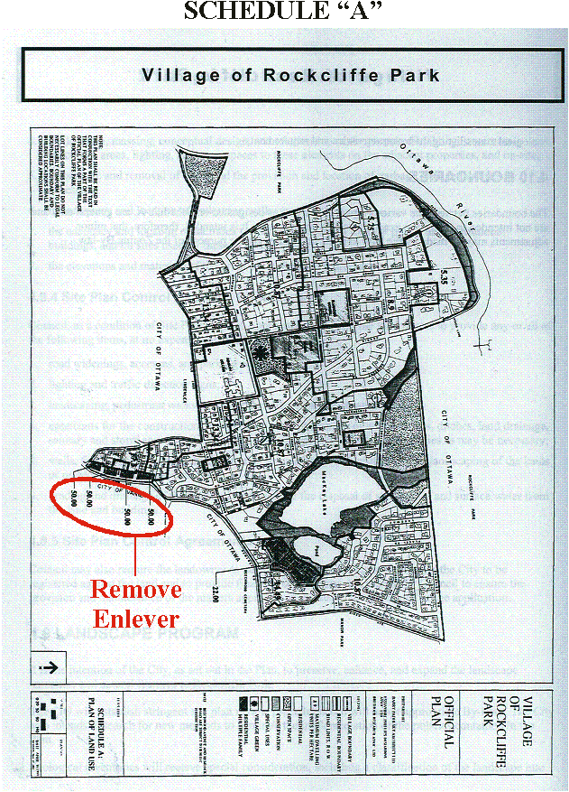
The Beechwood Community Design Plan conforms to the City Council Approved Official Plan and to the Rockcliffe Park Secondary Plan except that:
- the 50.00 units per hectare residential density cap that applies to the properties that abut Beechwood Avenue in the Rockcliffe Park Secondary Plan is insufficient to accommodate the level of intensification as described in the Community Design Plan.
DISCUSSION
Recommendation 1a), approve the Beechwood Community Design Plan.
The planning area is identified in Document 1 and the Beechwood Community Design Plan is contained in Document 2. The goal of the Plan is to provide a broad and integrated 20-year vision for the revitalization of the street. The Plan has met all of the objectives contained in the terms of reference and the Official Plan and has been prepared in a collaborative way, in consultation with property owners, businesses and the surrounding community. Refer to Document 3 Consultation Details. The key issues involved with the development of this Plan are described below.
Development Strategy
A development strategy was prepared for each of three identified sectors of Beechwood Avenue based on the public response to the ideas and recommendations developed at an urban design workshop. Many specific development opportunities have been identified including public improvements such as the entry to Genest Park and a roundabout by the Beechwood Cemetery.
Traffic and Parking
A consultant, National Capital Engineering Limited, was hired by the City to review traffic issues and staff undertook a separate and detailed parking review. The two studies reached the following key conclusions:
- There is an opportunity to modify and narrow the roadway east of Springfield Road while maintaining acceptable roadway operations.
- The Vanier Parkway, Mackay and Springfield intersections will exhibit poor levels of service regardless of any new development proposed in the planning area.
- There are indications that on-street parking in the sector closest to the St. Patrick Street Bridge is nearing capacity. Measures are proposed to provide more spaces which should increase capacity in the future.
- In the rest of the planning area, there is a significant surplus of parking spaces.
Building Height
Two views about building height have been consistently expressed throughout the planning process. One view is that building heights should remain low and village-style, with higher mid-rise heights at identified nodes and intersections. The other view is that mid-rise heights should be more prevelant and perhaps there are specific locations for more. The Plan was guided by both views. There were practical reasons to apply added height in some situations, for example, to avoid significant down-zoning and to apply the principles of intensification as expressed in the Official Plan. Where higher heights are permitted, the portion of buildings above three storeys will be setback further from the street so as to present a village-style of development along Beechwood Avenue.
The Waterfront Project
The purpose of the Waterfront Project is to develop a small pavilion that will allow people to sit by the water during summer months and enjoy the view and perhaps rent a canoe or kayak. Since the City owns the property, it can apply strict performance standards to any future use of the land.
It is recommended that the Beechwood Community Design Plan be approved as contained in Document 2.
Recommendation
1b, approve the amendment to the Rockcliffe Park Secondary Plan.
The Rockcliffe Park Secondary Plan contains a provision that caps the maximum residential density for properties that abut Beechwood Avenue, from Acacia Avenue to Oakhill Road on the north side of Beechwood Avenue, at 50.00 units per hectare and the Rockcliffe Park Zoning By-law contains an associated cap of 55.00 units per hectare. This, for example, would mean that the block face from 241 to 251 Beechwood Avenue, which has 57 metres (or 187 feet) of frontage and which presently contains five residential buildings could only accommodate a maximum of eight units at a maximum of 50.00 units per hectare. This maximum unit provision should be eliminated because:
- It is too low to accommodate the intensification envisioned in this Plan.
- It is a form of double control over development, which is confusing and unnecessary. Building height and building envelope provisions are felt to provide sufficient control over development.
The
Amendment to the Rockcliffe Park Secondary Plan, contained in Document 4,
removes the residential density cap along Beechwood Avenue. The list of zoning
changes, contained in Document 5, removes the associated residential density
cap from the Rockcliffe Park Zoning By-law. It is therefore recommended that
these amendments be approved.
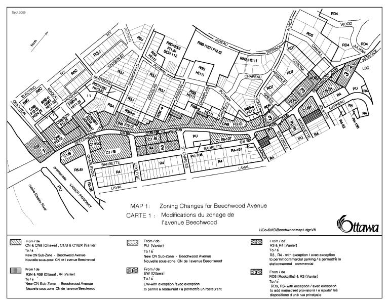
Recommendation 1c), approve the amendments to the former City of Ottawa Zoning By-law.
The CN zoning of the former City of Ottawa is the template that was used to create the new zoning for Beechwood Avenue. Changes include the following:
- Retain the existing provisions in the CN subzone.
- Remove the references to floor space index (FSI) as a regulation. With the appropriate building height and setback provisions in the Zoning By-law, it is felt that FSI control is not necessary. It is a second form of control that often permits differing and usually lesser amounts of development.
- Require that the principle entry be from Beechwood Avenue and that 50% of the Beechwood façade be door or window openings.
- Require ground floor commercial along Beechwood.
- Modify slightly the yard provisions to encourage the development of a pedestrian mainstreet.
- Include the residentially-zoned properties at 11 Champlain Street, 19-23 Langevin Avenue(east side) and 12 Douglas Street in the CN Zone.
- Create waterfront provisions in the EW Environment Waterfront Zone beside the St. Patrick Street Bridge.
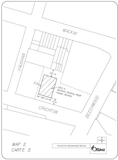
- Maximum building heights are increased to 20 m (from 18 m) with the following exceptions:
o Lowered to a maximum 15 m for the properties at 67-127 Beechwood Avenue, 15‑23 Langevin Avenue (east side), 5 Champlain Street (east side), 143 Putman Avenue (east side)
o Increased to 15 m for the properties at 11 Champlain Street, and 21-23 Langevin Avenue
o Increased to 25 m at the intensification site identified in a hatched marking on Map 2 in Document 5.
Recommendation 1d), approve the amendments to the former City of Vanier Zoning By-law.
The CN zoning of the former City of Ottawa is the template that was used to create the new zoning for Beechwood Avenue. Changes to the Vanier By-law include the following:
- Apply the CN Zone provisions (as above) to the District Commercial zoning in the former Vanier Zoning By-law and change the residential zoning for the following properties to the District Commercial Zone: 9 and 13 Marier Avenue, 9 and 11 Marquette Street and 10 and 12 Jolliet Street.
- Maximum building heights are increased to 20 m (from "three storeys") with the following exceptions:
- Increased to a maximum 15 m for the properties: from the Vanier Parkway to Charlevoix Street; from the east property line of the 7-Eleven store to the west side of Marier Avenue; from the Ottawa Fire Station to the west property line of the Rockcliffe Terrace condominium
- Change to a maximu of 11 m on the east half of 92 Beechwood Avenue
- Retain the St. Charles Church property in the public use zone with a new maximum building height of 15 metres.
- Retain the residential properties at 63 to 67 Barrette Street (north side) in the residential zone with a new maximum building height of 15 metres.
Recommendation 1e), approve the amendments to the former Village of Rockcliffe Park Zoning By-law. The existing RD9 residential zoning remains for those Rockcliffe properties along Beechwood Avenue with the following changes applied to the properties at 2 Acacia Street, 207 Beechwood Avenue and 229 to 255 Beechwood Avenue:
- New development should be oriented to Beechwood Avenue.
- The references to FSI ratio requirements have been removed as a regulation and the standard home-based business provisions have been modified so as to provide a slightly wider range of options for the use of these residential properties.
- The maximum building height has been increased from 10.6 m (3½ storeys) to 12.5 m (four storeys) to reflect the desired minimum height for four-storey residential buildings on Traditional Mainstreets.
Once approved by Council, the Beechwood zoning changes mentioned above will be integrated with the revised draft Comprehensive Zoning By-law that will be prepared in advance of the public hearings for the Comprehensive Zoning By-law in early 2007. The Beechwood zoning changes respect the principles and basic standards for Traditional Mainstreets as contained in the draft Comprehensive Zoning By-law and have been modified where appropriate to reflect the unique circumstances of Beechwood Avenue and the planning directions contained in the Community Design Plan.
Visualization
Techniques
As part of the community design plan project, the City undertook to explore four visualization techniques as part of a pilot project in the undertaking of community design plans:
- A computer-based 3-D Model
- PhotoShop Illustrations
- Free-hand sketches
- Posting an animated version of the 3-D Model on the City's website
Three of the techniques have been finalized and the products of all three are contained in the Beechwood Community Design Plan. These techniques proved to be successful tools in the planning process. They enabled the project team to make more informed decisions and helped the public to more clearly understand some of the urban design concepts presented in the Plan. Staff from the Surveys and Mapping Unit of Corporate Services prepared the 3-D Model (in consultation with planning staff).
Although PhotoShop illustrations are less time-consuming, they are more useful at illustrating individual sites or ideas and are best at preparing before and after images.
For a skilled designer, the free-hand sketches were the quickest to do. They are better than PhotoShop in depicting exactly what the designer wants to illustrate however the impact is less than a good PhotoShop illustration.
A fourth pilot method of visualization will be completed after the Community Design Plan is approved. Surveys and Mapping staff will create a movie clip of the 3-D Model similar in nature to the movie clips created for the light rail project. The GIS Technical Support Group will also investigate the creation of a 3-D Adobe PDF file for posting on Ottawa.ca. (A draft version of the movie clip is on the City's website under Public Consultation - Beechwood CDP.) It should be noted however that given the current tools, objects such as trees, human figures, cars etc will not appear on either model. If this pilot is successful, it could be used in future Community Design Plans to help the public visualize the future state of their community.
CONSULTATION
A summary of
the public consultation, including the comments received, are detailed in
Document 3 attached. Generally, the community and local businesses support the
Community Design Plan and the Rockcliffe Park Residents Association supports
the Rockcliffe Park Secondary Plan Amendment, as submitted.
FINANCIAL IMPLICATIONS
The Community
Design Plan anticipates that the streetscaping improvements will be implemented
through the City's regular road maintenance programs. Some specific
improvements could be done on a cost and/or revenue sharing basis, such as:
- for the Rideau River
and Beechwood Avenue waterfront project, the waterfront pavilion could be
constructed privately in return for a long-term lease on the City-owned
land. The estimated cost to construct the pavilion is between $350, 000
and $400,000.
- for the Beechwood Cemetery roundabout, some of the capital improvement and maintenance costs (i.e. landscaping) in the roundabout could be paid by the Beechwood Cemetery. The estimated cost to install a high quality entrance sign and to landscape the roundabout is between $25,000 and $125,000.
SUPPORTING DOCUMENTATION
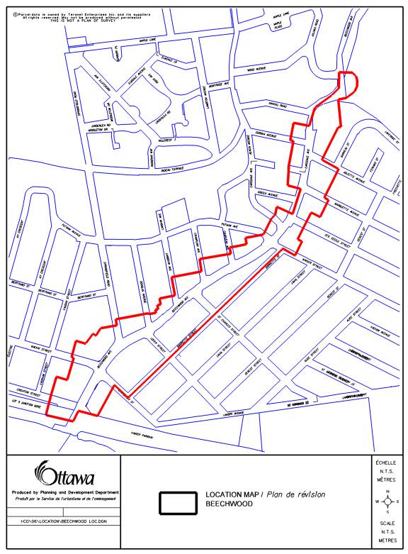
Document
1 Location Map
Document 2 Beechwood Community Design Plan (copies on
file with the City Clerk and distributed separately)
Document
3 Consultation Details
Document 4 Amendment
to the Rockcliffe Park Secondary Plan of the City Council Approved Official
Plan
Document
5 List of Zoning By-law changes
including three zoning maps
DISPOSITION
Planning and
Growth Management Department, Planning and Infrastructure Approvals Branch to:
§
Prepare
implementing By-laws
§
Notify
persons who made oral or written submissions at the Planning and Environment
Committee meeting and all persons and public bodies who requested to be
notified of the amendments
§
Advertise
the adoption of the amending Zoning By-laws.
Corporate Services
Department, Legal Services Branch to forward implementing by-laws to City
Council.
DOCUMENT 1
LOCATION
MAP
DOCUMENT 3
The
City has sponsored four public information and comment sessions for the
Beechwood Avenue CDP project:
- Public Open House -
Saturday, April 30, 2005
- Community Meeting
-Draft Planning and Design Proposals Wednesday, October 5, 2005
- Community Meeting - Draft
Parking and Traffic Proposals Thursday, January 19, 2006
- Community Meeting –
Draft CDP, Official Plan Amendment and Zoning Amendment July 5, 2006
In
all four cases, the public was notified of the session via: direct mail
delivery to all property owners and businesses within the planning area, e-mail
notice to all those on the contact list. For the first three, notice was also
provided via advertisements in community newspapers.
The
following are the public comments received based on the Summary document
presented at the October, 2005 community meeting.
|
Nature of Comment |
No. |
Planning Response |
|
General
support for the planning concepts (fully or with minor changes). Lots of good
ideas, creative concepts, exciting vision. Heading in the right direction.
Like the village concept. |
20 |
This
indicates broad support for the planning approach. |
|
Specific
support for the following ideas: §
The roundabout (4); §
The waterfront concept
(3); §
Anchor stores at
either end of Beechwood (2); §
The entry to Genest
Park from Beechwood (2); §
The Carsdale
pedestrian walkway (2). |
13 |
This
indicates support for some of the specific ideas mentioned in the CDP
summary. |
|
Dedicated bike lanes on
Beechwood are preferred. (9) Put the bikes on Barrette. (1) Bike lanes will congest
traffic. (2) |
12 |
It
is suggested that dedicated bike lanes be included in the CDP. However there
may be choke points that will not be wide enough to accommodate them. |
|
Beechwood is already
congested. There is concern that the proposed development may worsen it. (9)
Where are all of these people going to park? (1) People worried about
congestion are not necessarily against the CDP. (1) |
11 |
The City hired National Capital Engineering to
undertake a Transportation Review of the Planning Area. §
Congestion will worsen
west of Springfield with or without the development proposed in the CDP. §
Congestion is not a
serious issue east of Springfield. |
|
Reduce the size of the bump-outs
so they do not restrict on-street parking. They are hazardous to cyclists and
motorists. |
9 |
The
bump-outs are proposed to provide a pedestrian-focus for the street similar
to Laurier Avenue East. They are subject to further consultation upon implementation
(in the future). |
|
A certain amount of density
and traffic is necessary. The City should press on with the CDP. Higher
buildings should be permitted: §
At some
intensification sites; §
East of Marier (south
side); §
Between Champlain Street
and Chapleau (north side) §
At 131 Beechwood
Avenue. |
7 |
Adjust
the development strategy in the CDP and the zoning provisions to reflect the
following changes to building height: §
Increase from 3-storeys
(Vanier By-law) to 20 m on the south side between Charlevoix and Loyer, at
the 7-Eleven property and between Marier and the Fire Station; §
Keep the 20 m height
for the property at 131 Beechwood Avenue; §
Only decrease from 18
m to 15 m, instead of the 11 m as was first proposed, between Champlain
Street and Chapleau; §
Increase of 18 m to 25
m at the intensification site as illustrated on Maps 2 and 3 of Document 5. |
|
Keep the street narrow. No
more than one lane each way with on street parking to calm traffic. |
6 |
The
CDP proposes to keep the street as narrow as possible without adversely
affecting its function as a transportation corridor. |
|
Discourage cut-through
traffic in New Edinburgh and on Crichton, Barrette and Charlevoix Streets. Make
Barrette one-way at Marier to reduce eastbound traffic. |
6 |
Recommend
that Traffic and Parking Operations staff review these ideas for
implementation. |
|
The CDP should promote
transit. (4) Could we get light rail on Beechwood? (1) |
5 |
The
CDP will integrate bus transit, as it exists today. A Light Rail EA for the
Rideau-Montreal Road Corridor is underway and will include an evaluation of
the Beechwood-Hemlock corridor. |
|
Ensure development is
controlled and sustainable, not too high. Do not over-develop. |
5 |
All
development proposed in the Planning Area is infill to mid-rise in height.
High-rise development is not permitted. |
|
Another traffic signal is
needed for pedestrians to cross along the eastern part of Beechwood. |
3 |
At
the present time, warrants do not justify signalizing the Joliet Street
intersection. This could change as the Rockliffe Node develops. The
signalization of the intersection could be a condition of development
approval. |
|
Snow banks and parking on
both sides of the street blocks traffic. Barrette, Putman, Douglas. |
3 |
Recommend
that Traffic and Parking Operations staff review the idea of eliminating
parking from one side of Douglas Street during winter months. |
|
Remove the morning peak period
parking between Springfield and Douglas (Second Cup). (2) Extend the afternoon peak
period parking prohibition from 5:30 to 6:30 between the Vanier Parkway and
Charlevoix. (1) |
3 |
Recommend
that Traffic and Parking Operations staff review both ideas for
implementation. |
|
The St. Charles Sector
should not be singled-out as a heritage sector. |
2 |
The
references to heritage character in relation to the St. Charles Sector should
be changed to village character. |
|
Delivery trucks for The Works
are problematic. As a suggestion, convert the Bus Stop in front of The Works
to a Loading Zone. |
2 |
Recommend
that Traffic and Parking Operations staff review this idea for
implementation. |
|
Do not permit commercial at
Loyer. |
1 |
Initially,
commercial uses were proposed at the corner of Loyer and Barrette Streets.
This provision has been removed from the CDP and the list of zoning changes. |
|
Do not rezone property at
139 Putman. |
1 |
Keep
existing zoning. |
|
Don’t eliminate private parking
spaces. |
1 |
Many
of the references to reduced parking in the proposed zoning reflect variances
for approved developments on existing properties. Two situations were added,
one for the Loeb property and the other for the Adjust property as a means to
encourage the right kind of infill development. Both should remain in the
Plan. |
|
Proposed rear and side yard
setbacks will restrict development potential. |
1 |
The
“all other cases” rear yard setback in the proposed zoning provisions is 3.0 m
when there is no minimum in the existing by-law. The “default” setback has
been returned to no minimum. |
|
Remove 255-259 Beechwood
Avenue from the Planning Area. |
1 |
259
Beechwood Avenue has been removed from the Planning Area. |
Conservation Authority
§
Changes to the EW
zoning should continue to have a 30-metre setback. §
RVCA permits required
in the EW area; §
Geotechnical review
for slope stability; §
Evaluation required
for significant fish habitat. |
1 |
Development
within the Special Waterfront Area will be required to respect the 30 m
setback and any studies will have to be submitted if required by the
Conservation Authority. |
Ottawa Hydro
Possible conflict between building setbacks and the existing
overhead high voltage lines. |
1 |
Add
the following provision: §
In the case of a hydro pole, the
setback may be 2 m, and from a high voltage power line, the setback may be 5
m. |
Rockcliffe Park Residents Association
§
Support the height increase
from 10.6 m to 12.5 m at 241-251 Beechwood Avenue. §
Support removing the
FSI ratio in the RD9 Zone. §
Opposed to adding the
three proposed uses: home occupations, bed and breakfast and artist studio. |
1 |
The
Official Plan requires that development opportunities be identified through
the CDP process. §
The zoning height will
be increased from 10.6 m to 12.5 m for the properties at 2 Acacia Street, 207
Beechwood Avenue and 229-255 Beechwood Avenue. §
The FSI ratio is
removed. §
A home-based business is
added. §
An Official Plan
amendment is required to remove the maximum residential density of 50.00
units per hectare that relates to these properties in the Rockcliffe Park
Secondary Plan. |
The
following are the multiple comments (two or more) provided by the public on or
after the July 5, 2006 Community Consultation held at St. Charles Church.
|
Public Comment |
No. |
Planning Response |
|
Do not permit a restaurant on
the waterfront lands. Perhaps a small pavilion would be OK. |
6 |
The
restaurant use has been removed. |
|
Positive
comments - “very impressive plan”, “well thought-out”, “good effort”,
“clearly laid out, excellent”, “like info”. |
5 |
This
highlights that there is general public support for the Plan. |
|
Do not permit the 27 m
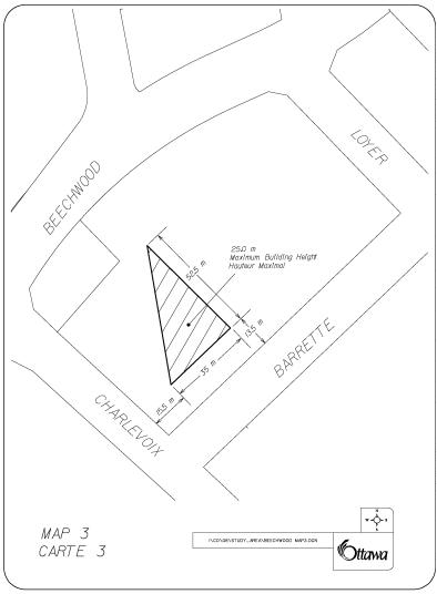
building height on the Loeb block. Concerned about large blank walls. |
3 |
On
the Loeb block, the triangular area closest to Charlevoix Street has been
removed from Map 3 of Document 5, which reduces its height from 27 m to 20
m. The second triangular area has
been reduced from 27 m to 25 m. |
|
Do not permit buildings
higher than three to four storeys along Beechwood Avenue. |
3 |
The
requirement that buildings be setback further from the street after three
storeys should provide the right balance to attract compatible, village-style
development. |
|
Concerned about increased
traffic from the Rockcliffe Air Base development. |
2 |
The
Transportation Review, prepared by National Capital Engineering, indicates
that the development at the Rockcliffe Air Base will not significantly affect
the volume of traffic along Beechwood Avenue. |
|
Object to the traffic bottleneck
at the Vanier Parkway/Beechwood Avenue intersection. |
2 |
The
traffic congestion at the intersection of the Vanier Parkway and Beechwood
Avenue will continue with or without the development proposed along Beechwood
Avenue. There are no proposals in the streetscape and corridor strategy to
reduce the road cross-section at this location. |
|
The Loeb grocery store and
accessible parking are important to the surrounding neighbourhood. |
2 |
The
Plan proposes to continue to permit a grocery store use on the Loeb block and
to allow parking underground. |
|
Oppose parking on the St.
Patrick Street Bridge. |
2 |
Parallel
parking can be provided on the north side of the bridge without affecting
vehicular, bicycle or pedestrian traffic. |
|
Oppose angled parking along
Charlevoix Street. |
2 |
Angled
parking along Charlevoix may have a positive traffic-calming effect. |
|
Would prefer a plan for a
larger area that includes the Rockcliffe Air Base and Claridge lands. |
2 |
A
Community Design Plan is being initiated for the Rockcliffe Air Base
redevelopment. The Claridge lands are not part of the designated Mainstreet,
which is the focus of this CDP. |
Bell Canada
For security reasons, Bell does
not support the vertical segregation of Bell utility installations. |
|
The
vertical segregation of utility installations has been removed. |
DOCUMENT 4
|
|

|
|
Amendment to the
Official Plan of the City of
Ottawa, 2003
Volume
2A, Village of Rockcliffe Park Secondary Plan