|
7.
OFFICIAL PLAN AND ZONING AMENDMENT- 545-729 KING
EDWARD AVENUE PLAN OFFICIEL ET
ZONAGE - 545-729, AVENUE KING EDWARD |
Committee recommendationS AS AMENDED
1.
That Council approve and adopt an amendment to the City
of Ottawa Official Plan to:
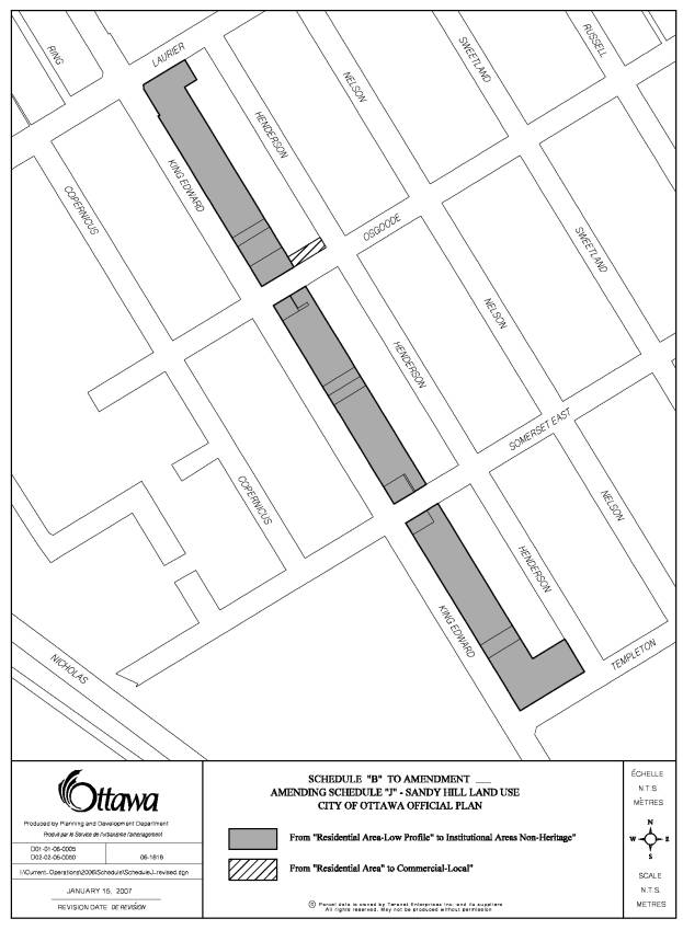
a)
Modify Schedule J, the Land Use Schedule of the Sandy
Hill Secondary Plan included in Volume 2-A to redesignate the lands located
south of Laurier Avenue East to Templeton Street, on the east side of King
Edward Avenue from Residential to Institutional;
b)
Modify Schedule J, the Land Use Schedule of the Sandy
Hill Secondary Plan included in Volume 2-A to redesignate the lands located
east of King Edward Avenue and west of Henderson Avenue on the north side of
Osgoode Street from Residential to Local Commercial; and
c)
Modify the Institutional Policy (5.3.2 i.) in the Sandy
Hill Secondary Plan to allow a mix of institutional, commercial and residential
uses along the King Edward Corridor.
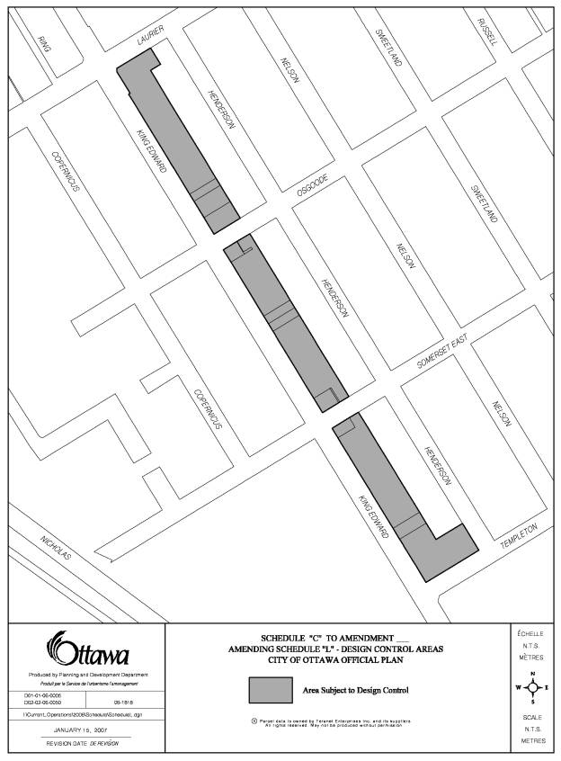
d)
Modify Schedule L, Design Control Areas to include the
lands located south of Laurier Avenue East to Templeton Street on the east side
of King Edward Avenue within the area that is subject to Design Approval,
all
as detailed in Document 2.
2. That the Planning and
Environment Committee recommend Council approve an amendment to the former City
of Ottawa Zoning By-law, 1998, to:
a)
Establish a new Institutional I2E Subzone to be known
as the University of Ottawa King Edward Precinct Zone that allows for mixed
uses,
b)
Change the zoning for the lands located on the east
side of King Edward Avenue, south of Laurier Avenue East and north of Templeton
Street from Residential R5C[89] H(13.8), CL2[455] F(1.0), CL2 F(1.0), CL2[456]
F(1.0) to the new Institutional I2E
Subzone with exceptions,
c)
Change the Institutional I2A [573] F(3.0) zone for the
lands located along the west side of King Edward Avenue south of Laurier Avenue
East to the new Institutional I2E subzone with exceptions and a 3.0 FSI,
d)
Delete specific provisions in the Residential R5C[89]
H(13.8) exception zone for the lands located on the west side of Henderson
Avenue south of Laurier Avenue East and north of Templeton Street,
e)
Delete specific provisions pertaining to gross floor
area located in the Residential R5C[89] H(13.8) zone from the Institutional I2A
[573] F(3.0) zone and from the Local Commercial CL2 [456] zone for the lands on
the south side of Osgoode Street, east of King Edward Avenue
f)
Change the zoning for the lands located along the east
side of King Edward Avenue south of Templeton Street and north of Mann Avenue
from a Residential R5C[89] H(13.8) zone and a Leisure L3 [327] zone to an I2A
Subzone with an exception to allow for a sports complex,
g)
Change the zoning for 109 and 113 Osgoode Street from
Residential R5C[89] H(13.8) to a Local Commercial CL1 F(1.0) zone,
h) Modify Neighbourhood Monitoring Area Number 20, Sub-Area 1, and Sub-Area 2 to include an Heritage Overlay,
all as shown
on Document 1 and detailed in Documents 3 and 3A.
3. That
Document 3, Details of Recommended Zoning contained within Report Reference
ACS2007-PTE-APR-0022 dealing with an Official plan Amendment and Zoning
Amendment for 545-729 King Edward (the King Edward Precinct of the University
of Ottawa) be modified as follows:
Replace
the term "minimum requirement" where it appears in Section 3(b) of
Document 3 with the word "maximum".
And that no further notice
be provided pursuant to Section 34(17) of the Planning Act, RSO 1990.
4. That Document 3,
Details of Recommended Zoning contained within Report Reference
ACS2007-PTE-APR-0022 dealing with an Official plan Amendment and Zoning
Amendment for 545-729 King Edward (the King Edward Precinct of the University
of Ottawa) be modified to delete "bar" from the list of permitted
commercial uses set out in Section 3(b), and;
That
no further notice be provided pursuant to Section 34(17) of the Planning Act,
RSO 1990.
RecommandationS modifiÉeS du Comité
1.
Que
le Conseil approuve et adopte une modification au Plan officiel de la Ville
d’Ottawa afin :
a)
de
modifier l’annexe J, Plan d'utilisation du sol, du Plan d’aménagement
secondaire de la Côte-de-Sable inclus dans le volume 2-A de manière à faire
passer d’Utilisation résidentielle à Utilisation institutionnelle la
désignation des terrains situés du côté est de l’avenue King Edward entre
l’avenue Laurier Est et la rue Templeton,
b)
de
modifier l’annexe J, Plan d'utilisation du sol, du Plan d’aménagement
secondaire de la Côte-de-Sable inclus dans le volume 2-A de manière à faire
passer d’Utilisation résidentielle à Utilisation commerciale locale les terrains
situés du côté nord de la rue Osgoode entre les avenues King Edward et
Henderson,
c)
de
modifier l’Utilisation institutionnelle (5.3.2 i.) dans le Plan d’aménagement
secondaire de la Côte-de-Sable de manière à permettre un mélange d’utilisations
institutionnelles, commerciales et résidentielles dans le couloir de l’avenue
King Edward,
d)
de
modifier l’annexe L, zone de contrôle de la conception urbaine, de manière à
inclure dans le secteur assujetti à l’approbation de la conception urbaine les
terrains situés du côté est de l’avenue King Edward entre l’avenue Laurier Est
et la rue Templeton,
tel qu’il est indiqué en détail dans
le document 2;
2.
Que
le Conseil approuve une modification au Règlement municipal de zonage de
l’ancienne Ville d’Ottawa, 1998, afin :
a)
de
créer une sous-zone institutionnelle I2E (zone du district de l’Université
d’Ottawa-avenue King Edward) qui permet des utilisations mixtes,
b)
de
faire passer le zonage des terrains situés du côté est de l’avenue King Edward
entre l’avenue Laurier et la rue Templeton de zone résidentielle R5C[89]
H(13.8), CL2[455] F(1.0), CL2 F(1.0), CL2[456] F(1.0) au nouveau zonage
(sous-zone institutionnelle I2E assortie d’exceptions),
c)
de
faire passer le zonage des terrains situés du côté ouest de l’avenue King
Edward au sud de l’avenue Laurier de zone institutionnelle I2A [573] F(3.0) au
nouveau zonage (sous-zone institutionnelle I2E assortie d’exceptions et d’un
RPS de 3.0),
d)
d’exempter
les terrains situés du côté ouest de l’avenue Henderson entre l’avenue Laurier
Est et la rue Templeton de dispositions particulières de la zone résidentielle
assortie d’exceptions R5C[89] H(13.8),
e)
d’exempter
des dispositions concernant la surface de plancher hors œuvre brute propres à
la zone résidentielle R5C[89] H(13.8) les terrains situés du côté sud de la rue
Osgoode à l’est de l’avenue King Edward dont le zonage est zone
institutionnelle I2A [573] F(3.0) et zone de commerces locaux CL2 [456],
f)
de
faire passer le zonage des terrains situés du côté est de l’avenue King Edward
entre la rue Templeton et l’avenue Mann de zone résidentielle R5C[89] H(13.8)
et de zone de loisirs L3 [327] au zonage sous-zone I2A assortie d’une exception
permettant la présence d’un complexe sportif,
g)
de
faire passer le zonage du 109 et du 113 de la rue Osgoode de zone résidentielle
R5C[89] H(13.8) à zone de commerces locaux CL1 F(1.0),
h)
de
modifier les sous-secteurs 1 et 2 du secteur soumis au contrôle de
l’application no 20 de manière à les assujettir à des
dispositions relatives à la protection du patrimoine,
tel qu’il est indiqué dans le
document 1 et expliqué en détail dans les documents 3 et 3A.
3. Que le document 3 du rapport no ACS2007-PTE-APR-0022,
intitulé Details of Recommended Zoning (Détails du zonage recommandé), qui
porte sur une modification au Plan officiel et une modification de zonage
visant les 545‑729 de l’avenue King Edward (secteur King Edward –
Université d’Ottawa), soit modifié comme suit :
dans la section 3(b) du
document 3, remplacer l’expression « minimum requirement »
(exigence minimale) par « maximum » (limite);
Et qu'aucun autre avis ne soit donné
à ce sujet, conformément au paragraphe 17 de l’article 34 de la Loi sur l'aménagement du territoire,
L.R.O. 1990.
4. Que le document 3 du rapport no ACS2007-PTE-APR-0022,
intitulé Details of Recommended Zoning (Détails du zonage recommandé),
qui porte sur une modification au Plan officiel et une modification de zonage
visant les 545‑729 de l’avenue King Edward (secteur King Edward –
Université d’Ottawa), soit modifié comme suit :
dans la
section 3(b) du document 3, supprimer le mot « bar » de la liste
des utilisations commerciales permises;
Et qu’aucun autre avis ne soit donné à ce
sujet, conformément au paragraphe 17 de l’article 34 de la Loi
sur l’aménagement du territoire, L.R.O. 1990.
Documentation
1.
Deputy
City Manager's report Planning,
Transit and the Environment dated
30 January 2007 (ACS2007-PTE-APR-0022).
2. Extract of Draft Minutes, 9
March 2007.
Report to/Rapport au :
Planning and Environment Committee
Comité de l'urbanisme et de l'environnement
and Council / et au Conseil
30 January 2007 / le 30 janvier 2007
Submitted by/Soumis par : Nancy Schepers, Deputy City Manager/
Directrice municipale adjointe
Planning, Transit and the Environment / Urbanisme, Transport en commun et
Environnement
Contact
Person/Personne Ressource : Grant Lindsay, Manager / Gestionnaire,
Development Approvals / Approbation des demandes d'aménagement
(613) 580-2424, 13242 Grant.Lindsay@ottawa.ca
|
SUBJECT: |
Official Plan and ZONING Amendment-
545-729 king edward avenue (FILE NOs. D01-01-06-0005 and D02-02-06-0050) |
|
|
|
|
OBJET : |
REPORT RECOMMENDATIONS
1.
That the Planning and Environment Committee recommend
that Council approve and adopt an amendment to the City of Ottawa Official Plan
to:
a)
Modify Schedule J, the Land Use Schedule of the Sandy
Hill Secondary Plan included in Volume 2-A to redesignate the lands located
south of Laurier Avenue East to Templeton Street, on the east side of King
Edward Avenue from Residential to Institutional;
b)
Modify Schedule J, the Land Use Schedule of the Sandy
Hill Secondary Plan included in Volume 2-A to redesignate the lands located
east of King Edward Avenue and west of Henderson Avenue on the north side of
Osgoode Street from Residential to Local Commercial; and
c)
Modify the Institutional Policy (5.3.2 i.) in the Sandy
Hill Secondary Plan to allow a mix of institutional, commercial and residential
uses along the King Edward Corridor.
d)
Modify Schedule L, Design Control Areas to include the
lands located south of Laurier Avenue East to Templeton Street on the east side
of King Edward Avenue within the area that is subject to Design Approval,
all as
detailed in Document 2.
2. That the Planning and Environment
Committee recommend Council approve an amendment to the former City of Ottawa
Zoning By-law, 1998, to:
a)
Establish a new Institutional I2E Subzone to be known
as the University of Ottawa King Edward Precinct Zone that allows for mixed
uses,
b)
Change the zoning for the lands located on the east
side of King Edward Avenue, south of Laurier Avenue East and north of Templeton
Street from Residential R5C[89] H(13.8), CL2[455] F(1.0), CL2 F(1.0), CL2[456]
F(1.0) to the new Institutional I2E
Subzone with exceptions,
c)
Change the Institutional I2A [573] F(3.0) zone for the
lands located along the west side of King Edward Avenue south of Laurier Avenue
East to the new Institutional I2E subzone with exceptions and a 3.0 FSI,
d)
Delete specific provisions in the Residential R5C[89]
H(13.8) exception zone for the lands located on the west side of Henderson
Avenue south of Laurier Avenue East and north of Templeton Street,
e)
Delete specific provisions pertaining to gross floor
area located in the Residential R5C[89] H(13.8) zone from the Institutional I2A
[573] F(3.0) zone and from the Local Commercial CL2 [456] zone for the lands on
the south side of Osgoode Street, east of King Edward Avenue
f)
Change the zoning for the lands located along the east
side of King Edward Avenue south of Templeton Street and north of Mann Avenue
from a Residential R5C[89] H(13.8) zone and a Leisure L3 [327] zone to an I2A
Subzone with an exception to allow for a sports complex,
g)
Change the zoning for 109 and 113 Osgoode Street from
Residential R5C[89] H(13.8) to a Local Commercial CL1 F(1.0) zone,
h) Modify Neighbourhood Monitoring Area Number 20, Sub-Area 1, and Sub-Area 2 to include an Heritage Overlay,
all as shown
on Document 1 and detailed in Documents 3 and 3A.
RECOMMANDATIONS DU RAPPORT
1.
Que
le Comité de l'urbanisme et de l'environnement recommande au Conseil
d’approuver et d’adopter une modification au Plan officiel de la Ville d’Ottawa
afin :
a) de modifier l’annexe J, Plan d'utilisation du
sol, du Plan d’aménagement secondaire de la Côte-de-Sable inclus dans le volume
2-A de manière à faire passer d’Utilisation résidentielle à Utilisation
institutionnelle la désignation des terrains situés du côté est de l’avenue
King Edward entre l’avenue Laurier Est et la rue Templeton,
b) de modifier l’annexe J, Plan d'utilisation du
sol, du Plan d’aménagement secondaire de la Côte-de-Sable inclus dans le volume
2-A de manière à faire passer d’Utilisation résidentielle à Utilisation
commerciale locale les terrains situés du côté nord de la rue Osgoode entre les
avenues King Edward et Henderson,
c) de modifier l’Utilisation institutionnelle
(5.3.2 i.) dans le Plan d’aménagement secondaire de la Côte-de-Sable de manière
à permettre un mélange d’utilisations institutionnelles, commerciales et
résidentielles dans le couloir de l’avenue King Edward,
d) de modifier l’annexe L, zone de contrôle de
la conception urbaine, de manière à inclure dans le secteur assujetti à
l’approbation de la conception urbaine les terrains situés du côté est de
l’avenue King Edward entre l’avenue Laurier Est et la rue Templeton,
tel qu’il est indiqué en détail dans
le document 2;
2.
Que
le Comité de l’urbanisme et de l’environnement recommande au Conseil
d’approuver une modification au Règlement municipal de zonage de l’ancienne
Ville d’Ottawa, 1998, afin :
a)
de
créer une sous-zone institutionnelle I2E (zone du district de l’Université
d’Ottawa-avenue King Edward) qui permet des utilisations mixtes,
b)
de
faire passer le zonage des terrains situés du côté est de l’avenue King Edward
entre l’avenue Laurier et la rue Templeton de zone résidentielle R5C[89]
H(13.8), CL2[455] F(1.0), CL2 F(1.0), CL2[456] F(1.0) au nouveau zonage
(sous-zone institutionnelle I2E assortie d’exceptions),
c) de faire passer le zonage des terrains situés
du côté ouest de l’avenue King Edward au sud de l’avenue Laurier de zone
institutionnelle I2A [573] F(3.0) au nouveau zonage (sous-zone institutionnelle
I2E assortie d’exceptions et d’un RPS de 3.0),
d) d’exempter les terrains situés du côté ouest
de l’avenue Henderson entre l’avenue Laurier Est et la rue Templeton de dispositions
particulières de la zone résidentielle assortie d’exceptions R5C[89] H(13.8),
e) d’exempter des dispositions concernant la
surface de plancher hors œuvre brute propres à la zone résidentielle R5C[89]
H(13.8) les terrains situés du côté sud de la rue Osgoode à l’est de l’avenue
King Edward dont le zonage est zone institutionnelle I2A [573] F(3.0) et zone
de commerces locaux CL2 [456],
f) de faire passer le zonage des terrains
situés du côté est de l’avenue King Edward entre la rue Templeton et l’avenue
Mann de zone résidentielle R5C[89] H(13.8) et de zone de loisirs L3 [327] au
zonage sous-zone I2A assortie d’une exception permettant la présence d’un
complexe sportif,
g) de faire passer le zonage du 109 et du 113 de
la rue Osgoode de zone résidentielle R5C[89] H(13.8) à zone de commerces locaux
CL1 F(1.0),
h) de modifier les sous-secteurs 1 et 2 du
secteur soumis au contrôle de l’application no 20 de manière à
les assujettir à des dispositions relatives à la protection du patrimoine,
tel qu’il est indiqué dans le
document 1 et expliqué en détail dans les documents 3 et 3A.
EXECUTIVE SUMMARY
Assumptions and Analysis:
The subject lands comprise four blocks bounded by King Edward Avenue to the west, Henderson Avenue to the east, Laurier Avenue East to the north and Mann Avenue to the south and comprise the lands fronting the west side of King Edward Avenue south of Laurier Avenue East and north of Templeton Street. This area will be referred to as the ‘King Edward Precinct’.
The applicant is proposing to amend the current Official Plan designation under the Sandy Hill Secondary Plan and the current zoning to allow for future developments consisting of a mix of institutional, commercial and residential uses along King Edward Avenue and residential uses only along Henderson Avenue.
The Department has reviewed the proposal and is recommending approval as it conforms to the overall policy directions of the City’s Official Plan, and provides for better integration of the institutional/commercial uses associated with the University of Ottawa with the Sandy Hill residential community.
Financial Implications:
N/A
Public Consultation/Input:
Comments were received from the public regarding this application including comments received as a result of a public meeting held by the Ward Councillor and written correspondence from the Community Association.
The community identified the following as the primary issues of concern: (1) the proposed height modifications along the east side of King Edward Avenue (2) traffic congestion (3) building design and (4) heritage impact.
RÉSUMÉ
Hypothèses et analyse
Les terrains visés sont situés dans quatre
îlots délimités par l’avenue King Edward à l’ouest, l’avenue Henderson à l’est,
l’avenue Laurier Est au nord et l’avenue Mann au sud, et comprennent les
terrains donnant sur le côté ouest de l’avenue King Edward entre l’avenue
Laurier Est et la rue Templeton. Ce secteur sera désigné sous le nom de
« district King Edward ».
Le requérant propose de modifier la désignation
actuelle du Plan officiel dans le Plan d’aménagement secondaire de la
Côte-de-Sable de même que le zonage actuel afin de permettre des aménagements
futurs correspondant à un mélange d’utilisations institutionnelles,
commerciales et résidentielles le long de l’avenue King Edward de même qu’à des
utilisations résidentielles seulement le long de l’avenue Henderson.
Le Service a examiné la proposition et en
recommande l’approbation puisqu’elle est conforme aux orientations stratégiques
générales du Plan officiel de la Ville et qu’elle permet une meilleure
intégration des utilisations institutionnelles et commerciales associées à
l’Université d’Ottawa dans la communauté résidentielle de la Côte-de-Sable.
Répercussions financières
S/O
Consultation publique/commentaires
De nombreux commentaires sur la présente
demande ont été exprimés, notamment à la suite d’une réunion publique tenue par
le conseiller du quartier, de même que sous la forme de lettres envoyées à ce
sujet par l’association communautaire du secteur. Les membres de la
collectivité ont cerné les principales sources de préoccupation
suivantes : 1) modifications proposées à la hauteur des bâtiments du
côté est de l’avenue King Edward; 2) bouchons de circulation; 3) conception des
bâtiments; et 4) incidence sur le patrimoine.
BACKGROUND
The subject lands comprise four blocks bounded by King Edward Avenue to the west, Henderson Avenue to the east, Laurier Avenue East to the north and Mann Avenue to the south as well as the lands fronting the west side of King Edward Avenue between Laurier Avenue East and Templeton Street. This area will be referred to as the ‘King Edward Precinct’.
The lands located within the King Edward Precinct on the east side of King Edward Avenue cover an area of approximately 63 700 square metres. The University of Ottawa owns approximately 87% of these lands with the remaining 13 % of these being privately owned. The lands along the west of King Edward Avenue form part of the main University of Ottawa campus and are owned by the University.
A variety of land uses, including institutional, commercial, residential and recreational, are located within the King Edward Precinct. One of the more prominent facilities within the subject area is the University Sports Complex, located on the southernmost block. West of King Edward Avenue is the main University of Ottawa campus. A residential neighbourhood, known as Sandy Hill, is located immediately to the east. Also nearby is the three-storey Franco-Jeunesse elementary school, on the east side of Henderson Avenue, and the Sandy Hill Park and Community Centre, east of Nelson Street. Small-scale commercial establishments are clustered to the east of the site along Laurier Avenue East, and along the south side of Osgoode Street between King Edward Avenue and Henderson Avenue.
Over time, the University of Ottawa intends to redevelop their landholdings in accordance with the University of Ottawa’s updated Master Plan for the King Edward Precinct. The King Edward
Precinct plan is the result of several ‘visioning’ exercises that have taken place in the community over the past two years in consultation with Sandy Hill residents, Action Sandy Hill, local businesses, and other stakeholders. This Plan provides direction to establish King Edward Avenue as a seam to provide for better integration and a transition between the main University of Ottawa campus west of King Edward Avenue and the Sandy Hill community east of Henderson Avenue; to sensitively promote good infill in the area; to enhance ground-level activity, and to bring stability to the residential component of the King Edward Precinct along Henderson Avenue. Changes include restoring Henderson Avenue to an attractive residential environment, and providing for a mix of University-related uses, commercial uses and residential uses to be located along King Edward Avenue with an underlying objective to enhance the image and urban quality of King Edward Avenue through the University campus.
DISCUSSION
Recommendation 1:
Official Plan
The King Edward Precinct along with the main University Campus located south of Laurier Avenue East and west of King Edward Avenue and the Sandy Hill residential area located to the east of the King Edward Precinct is designated General Urban Area on Schedule "B" Urban Policy Plan of the Official Plan. The General Urban Area designation permits a full range and choice of housing types to meet the needs of all ages and incomes in combination with conveniently located employment, service, cultural, leisure, entertainment and institutional uses. This designation facilitates the development of complete and sustainable communities. The non-residential uses permitted in this designation are to serve the everyday needs of the local community.
Non-residential uses, which serve wider parts of the city, are to be located at the edges of neighbourhoods on roads where the needs of these land uses can be more easily met and the impacts better controlled.
The King Edward Precinct is also subject to the policies of the Sandy Hill Secondary Plan, Volume 2A, of the Official Plan. The subject lands are located within the Low Profile Residential, Local Commercial and the Non-Heritage Institutional designations, as shown on Schedule "J" of the Official Plan. The purpose of the policies contained in the Sandy Hill Secondary Plan is to guide future growth and change in Sandy Hill. The policies specific to the Residential designation are directed to preserving and enhancing good housing stock, locating the different types of housing in appropriate areas, and to providing a wide variety of housing. The Local Commercial designation applicable to lands along the south side of Osgoode Street between King Edward Avenue and Henderson Avenue allows for small-scale commercial uses, which serves the local residents. The purpose of the policies associated with the Institutional designation is to permit orderly development of the University of Ottawa and to encourage useful links with the adjacent community.
Recommendation 1 a), b) and c) – Land Use Designation and Policy Changes (Sandy Hill Secondary Plan)
Extending the Institutional designation that applies to the main University Campus under the Sandy Hill Secondary Plan west of King Edward Avenue to include the lands owned by the University along the east side of King Edward Avenue and providing for lands within this designation along both sides of King Edward Avenue to be developed with a mix of institutional, commercial and residential uses will serve to establish a seam and better integrate the University with the Sandy Hill community. Currently, as a result of the zoning applicable to the King Edward Precinct, University uses can be established anywhere within the precinct, including those lands fronting onto Henderson Avenue and there are limits on uses that can serve both the University and the residential community. The proposed Official Plan Amendment in combination with the proposed zoning changes will limit University uses to only those lands within the precinct fronting onto King Edward Avenue with only residential uses fronting lands along Henderson Avenue. The additional commercial and residential uses to be permitted along King Edward will allow King Edward Avenue to evolve into a mixed-use area to serve both the University and the residential community.
This will also serve to provide a functional transition between the University Campus west of King Edward Avenue and the residential neighbourhood east of Henderson Avenue and will serve to better respond to the Residential policies of the Sandy Hill Secondary Plan. Henderson Avenue will be maintained as a residential street accommodating only residential uses to better support having the existing housing stock along Henderson maintained and enhanced. The proposed commercial uses to be permitted along King Edward Avenue are intended to serve and complement the local residential community as well as the student population.
The addition of a Local Commercial designation on the north side of Osgoode Street will complement and be consistent with the existing Local Commercial designation located on the south side of this street and will allow for Osgoode Street located between King Edward Avenue and Henderson Avenue to be established as a local commercial enclave linking the University Campus and the King Edward mixed-use area to the Sandy Hill Community.
Recommendation 1 d) - Urban Design
Consideration
Recommendation
1 d) recommends that Schedule L, Design Control Areas of the Official Plan, be
modified to include the lands proposed to be redesignated Institutional in the
Sandy Hill Secondary Plan. The current boundary of the Design Control Area
includes the University lands located to the west of King Edward Avenue. With approval of Recommendation 1 a), b) and
c), lands along both sides of King Edward Avenue can be developed with a
similar range of uses. Including the
lands east of King Edward Avenue within the area subject to design approval
will allow for a consistent approach to ensuring high quality design for
University buildings developed along both sides of King Edward Avenue. This ensures a consistent and compatible
expression for King Edward Avenue through the University Campus that will
contribute to the creation of lively places and enhance the quality of the
public realm and urban environment along King Edward Avenue.
Recommendation 2
Existing Zoning
The majority of the lands bounded by King Edward Avenue to the west, Henderson Avenue to the east, Laurier Avenue East to the north, and Templeton Street to the south are currently zoned R5C [89] H(13.8), a Low Rise Apartment Zone. This zoning designation has a height restriction of 13.8 metres. The permitted uses include but are not limited to the following: apartment building, stacked townhouses, townhouses, triplex, bed and breakfast, diplomatic mission, planned unit development etc. Exception 89 allows for additional uses such as post secondary educational institution and dwelling units. This exception also limits the size of a converted dwelling into a rooming house, and allows for parking in association with the University.
The properties located on the south side of Osgoode Street between King Edward Avenue and Henderson Avenue are currently zoned CL2[456], a Local Commercial Zone. This zoning designation allows residential uses, recreational athletic facility, parking garage, and parking lot. Restaurant full-service is permitted at the southeast corner of King Edward Avenue and Osgoode Street and a restaurant take-out is permitted at the southwest corner of Osgoode and Henderson Avenue.
The main University Campus located west of King Edward Avenue and South of Laurier Avenue East is zoned I2A [573] F(3.0), a Major Institutional zone applicable to post secondary institutions. This zone permits a variety of institutional types uses. An exception applies to this zone that allows parking for the university to be located anywhere on the campus, including university owned lands zoned residential east of King Edward Avenue and the allowed 3.0 Floor Space Index can be distributed anywhere over the University owned lands.
Finally, the lands currently occupied by the University of Ottawa Sports Complex building and playing field, are presently zoned R5C [89](13.8), a Low Rise Apartment Zone, and L3 [327], Community Leisure Zone respectively.
Recommendation 2 a), b) and c)
Recommendation 2 a) proposes that a new Institutional I2E subzone to be known as the University of Ottawa King Edward Precinct Zone be established and Recommendations 2 b) and c) apply this new subzone to lands along the east and west sides of King Edward Avenue between Laurier Avenue East and Templeton Street. The new subzone will allow for a mix of institutional, commercial and residential uses within the King Edward Avenue Precinct.
The proposed zone will retain the residential and institutional uses currently permitted under the R5 zone for lands east of King Edward and currently permitted under the I2A zone for lands west of King Edward and will introduce a new range of non-residential uses including more clearly defined University uses such as office and research facility as well as stand alone commercial and residential uses. This will allow for uses that may not be exclusively related to the University but that can also serve the local community to be established to give effect to transforming King Edward Avenue by providing uses that will serve to functionally join and integrate the University with the Sandy Hill community. King Edward Avenue will be identified as a transitional edge for the main campus where it begins to interface with the adjacent community and contribute to it not only being a significant element of the campus but also an important mixed use street for Sandy Hill.
The University is also requesting area specific provisions for lands located along the east side of King Edward Avenue and certain adjustments to performance standards for the lands located along the west side of King Edward Avenue that will contribute to future development providing a framework for establishing King Edward Avenue as a unique urban street for both the Campus and the Sandy Hill community. These area specific provisions and performance standard adjustments are recommended to be established through exception provisions to the new I2E subzone.
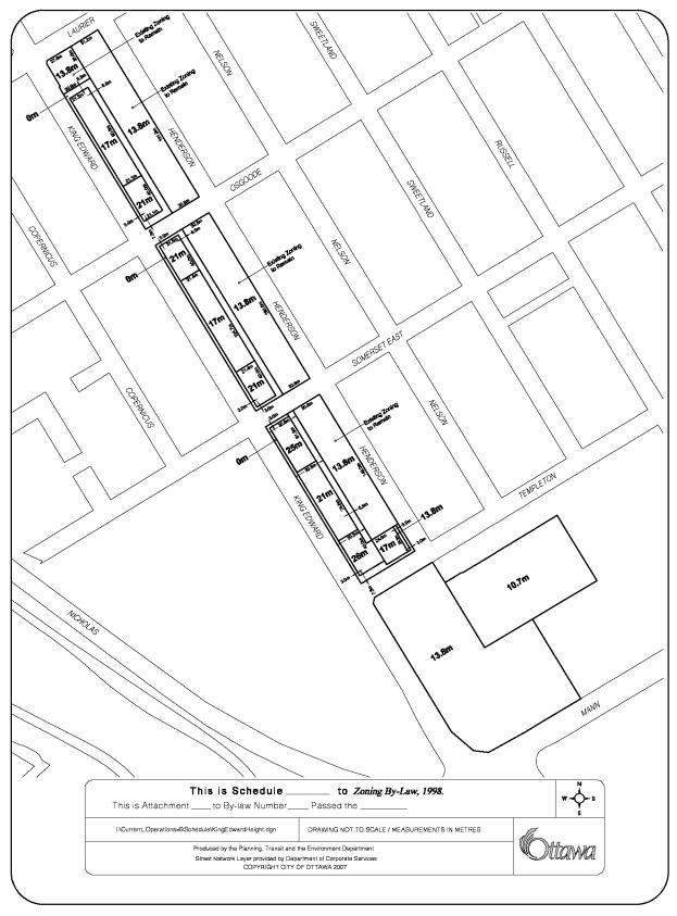
The area specific provisions for lands located along the east side of King Edward include setback provisions, height limits, and parking standards. Document 3b sets out a setback and building height schedule. With respect to setbacks, a 3.0 metre building set back is proposed along the King Edward Avenue frontage and along the intersecting streets to allow for providing a consistent landscape buffer along the street edge.
A set back of 7.5 metres is proposed along the north side of Osgoode Street at King Edward Avenue to allow for the inclusion of a plaza, which would ultimately increase street activity. The rear yard set back located mid block between King Edward Avenue and Templeton Street is proposed to be 6.5 metres and will accommodate a rear lane for vehicular access to underground parking. The introduction of a rear lane will eliminate the number of vehicular entrances off King Edward Avenue, assist in the location of underground parking and strengthen the block fabric by eliminating driveway gaps between buildings. This will allow for a consistent landscape treatment to be provided along King Edward Avenue, which will enhance the pedestrian environment.
The new built form to be provided within the King Edward Precinct contemplates changes to the maximum building heights now permitted along the east side of King Edward Avenue and at the southeast corner of Templeton Street and Henderson Avenue.
The height at the northeast corner of Laurier Avenue East and King Edward Avenue will remain 13.8 metres similar to the existing height along Henderson Avenue.
The proposed heights for the three blocks within the King Edward Precinct fronting the east side of King Edward Avenue vary from 17 metres to 26 metres with the highest heights being at intersections to anchor each individual block, as shown on Document 3b. The proposed increase in height is considered appropriate along King Edward Avenue, as it is an arterial road located at the edge of the residential community. Also, the lower building heights that will be retained at 13.8 m along the west side of Henderson Avenue will ensure that the increased heights to be allowed along King Edward Avenue will not impact on the low profile scale of the established residential area east of Henderson Avenue.
The height originally proposed by the applicant for the parcel of land located at the southeast corner of King Edward and Templeton Street was 29 metres. As a result of discussions between the applicant and Action Sandy Hill, the applicant has decided to reduce the proposed height to 26 metres. The revised height of 26 metres is considered appropriate at this location, as the topography of the site, with its steep slope, will serve to mitigate the profile of the building within the Precinct. This location serves as a gateway to the area and will allow for a built form focal point to be established for the southern approach to the University Campus.
The applicant undertook a sun/shadow analysis
to assess the potential shadow impacts associated with the building height
limits proposed to be established for lands along the east side of King Edward
Avenue. The study analyzed the shadows that could likely be expected from
developing the Precinct under the current zoning and that would be probable
with the proposed zoning changes. The analysis demonstrates that the proposed
heights along the east side of King Edward Avenue will have minimal impacts on
the adjacent properties/dwellings, with respect to loss of sunlight. Properties not abutting the site will have
little to no impact during the Spring and Fall Equinoxes. Three-dimensional modeling of the probable
development that could be achieved under the proposed zoning changes confirms
that the proposed heights are acceptable and do not negatively impact the
existing community.
Finally, the University is requesting a reduction to the parking requirement pertaining to commercial uses within the King Edward Precinct. Staff is supportive of the request to modify the parking requirement for commercial uses to be consistent with the requirement for similar uses within the Central Area. In addition to being in proximity to the Central Area, the King Edward Precinct is close to the Transitway and within walking distance of the University Transitway Station.
The performance standard modifications proposed to be established through exception provisions for the lands fronting the west side of King Edward Avenue provide for a minimum building setback of 3.0 m along street fronts to maintain a consistent setback pattern along the east and west sides of King Edward Avenue. Certain provisions of the current zoning applying to the lands related to density distribution and allowing parking for University uses to be located anywhere within the campus including the lands to be zoned Institutional along the east side of King Edward Avenue will be maintained. The current 3.0 Floor Space index will also be retained for the lands along the west side of King Edward Avenue.
The proposed rezoning to establish a mixed use Institutional zone for the lands along the east and west sides of King Edward Avenue meets the intent of the Official Plan. It permits development that satisfies the policies of a "General Urban Area" designation by providing residential intensification with commercial uses, which serves the local community and the student population. Future development will occur at an appropriate location along an arterial road, King Edward Avenue, and at the edge of an existing community, and immediately across from the main campus of the University of Ottawa. The proposed set backs are considered to be appropriate as they will provide for an adequate landscape buffer along King Edward Avenue, and provide adequate separation distance from the residential properties to the east of the King Edward Precinct. The proposed built form to be permitted with heights ranging from 13.8 m to 26 m are along the east side of king Edward Avenue are considered to be appropriate based on the physical and contextual attributes of the Precinct. Ground-oriented housing forms and building design that is sensitive to the existing heritage character of Henderson Avenue will be ensured by including a heritage overlay for Henderson Avenue, south of Laurier Avenue and north of Somerset Street East.
Recommendation 2 d) and e)
Recommendation 2 d) recommends that the exception within the R5C[89] H(13.8) zoning designation which will continue to apply to lands fronting Henderson Avenue be modified to eliminate “post secondary educational institution” as a permitted use. This amendment will eliminate any institutional uses relating to the University fronting onto Henderson Avenue and will support strengthening the residential character of Henderson Avenue. It will also establish a clear boundary between the mixed uses proposed along King Edward Avenue and the residential community to the east. In addition, the provision allowing the University to distribute its permitted gross floor area over their properties in the R5C[89] H(13.8) will be deleted from this zone as recommended in Recommendation 2 e).
Recommendation 2 f)
Recommendation 2f) proposes to rezone the Sports Complex Facility lands, which currently has two zoning designations. The section fronting King Edward Avenue is zoned R5C [89] H(13.8), Low Rise Apartment, and the other half of the parcel to the east is zoned L3 [327], a Community Leisure zone. The amendment to change the Low Rise Apartment Zone and Community Leisure zone to an Institutional subzone with an exception would better reflect the existing use of the University of Ottawa Sports Complex and would be consistent with the proposed zoning along King Edward Avenue. The existing 13.8 metre height limit on the south side of Templeton and east of King Edward will remain but will also be extended along the north side of Mann Avenue to reflect the existing Sports Complex facility. The permitted height of the playing field will remain 10.7 metres.
No changes are proposed to the zoning applying to the existing detached-dwellings located along Templeton Street, to the east of the Sports Complex.
Recommendation 2 g)
The establishment of a Local Commercial zone CL1 F(1.0) subzone along the north side of Osgoode Street between King Edward and Henderson Avenue will implement the proposed Official Plan amendment to designate this area as a local commercial area in the Sandy Hill Secondary Plan. As previously noted under the Official Plan amendment discussion, the establishment of a Local Commercial zoning along the north side of Osgoode Street will complement and be consistent with the existing Local Commercial zoning on the south side of Osgoode Street and will allow for Osgoode Street between King Edward Avenue and Henderson Avenue to be established as a local commercial enclave linking the University Campus to the Sandy Hill community.
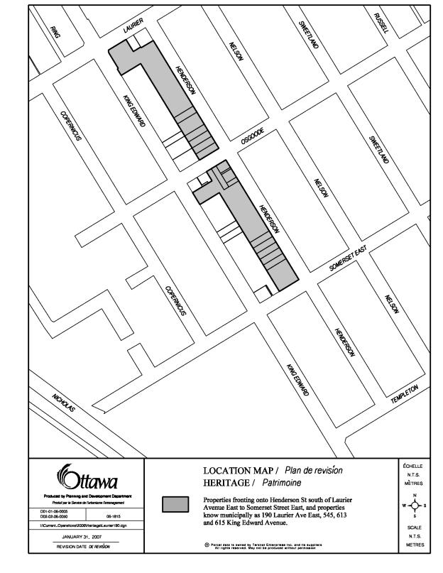
Recommendation 2 h)
A Heritage Impact Study was submitted
concurrently with the Official Plan and Zoning By-law Amendment applications. The Study examined the effect of the
development contemplated by the University’s Master Plan for the King Edward
Precinct on the heritage buildings and the context of the Precinct as a whole.
Recommendation 2 h) recommends that a Heritage
Overlay be imposed for the areas as shown on Document 3c. The heritage overlay
establishes provisions specific to properties accommodating buildings to
support building retention and requiring new development to exhibit similar
characteristics as existing buildings in terms of built form and massing.
The heritage overlay will ensure that the
heritage character established by the existing buildings exhibiting heritage
value along Henderson Avenue is maintained. The overlay will support the
delineation in character between the mixed-use area along King Edward Avenue
that would be accommodated by the amendments proposed to the Official Plan and
Zoning and the residential buildings on the east side of Henderson Avenue.
The heritage overlay will also serve to reinforce the residential character of Henderson Avenue in a way that respects the profile of the residential community located east of Henderson Avenue.
Other Planning Considerations
In addition to concerns related to building
heights, which has been addressed under the discussion, related to
Recommendation 2a), b) and c), the community also expressed concerns related to
traffic and servicing. In response to
the traffic concerns, the applicant undertook a Traffic and Transportation
Impact Study and its findings are supported by staff. An Addendum Report to this study was requested by staff to
confirm that the maximum development potential within the King Edward Precinct
was incorporated into the Study.
The subject area is very well served by the
local bus service, which travels along Somerset Street and Laurier Avenue, and
the rapid transit service which runs along the western boundary of the
campus. Pedestrian circulation is well
established with sidewalks located along both sides of the streets that bound
the King Edward Precinct.
An extensive pedestrian network also exists
within the main campus, which links the residential community to the rapid
transit service. In addition, the pedestrian bridge over the Rideau Canal will
enhance the overall pedestrian circulation in the area.
Over the years, the University of Ottawa has
developed a Transportation Demand Management Program, which has a number of
initiatives to reduce use of private automobiles by staff and students. These
focus on promoting walking, establishing bicycle storage facilities and
encouraging transit use by students and staff members.
The Traffic and Transportation Impact Study
prepared by the applicant looked at three land use scenarios, institutional,
residential and office, and the potential traffic impact depending on the
proposed use. Additional Traffic Impact
Studies will be required to be submitted for review and consideration once the
applicant is ready to proceed with specific development proposals in order to
evaluate the traffic expected to be generated by the proposed development.
Regarding potential traffic impacts associated
with the University onto Henderson Avenue, the Department is satisfied that
impacts will be minimal.
Non-residential University related uses are to be situated along
King Edward Avenue and will be of a scale that will not result in the
attraction of large volumes of vehicular traffic from outside the immediate
area. It is anticipated that through
the Site Plan Control Approval
process, vehicular access to at-grade or underground parking will be via a
private lane which will run parallel to King Edward Avenue and Henderson Avenue
to minimize any vehicular or traffic conflicts which may occur along Henderson
Avenue. In addition, the details of the
Zoning By-law amendment will allow for the proposed developments along King
Edward Avenue to establish off-site parking at the existing parking garage at
33 Mann Avenue, which currently has a parking surplus or within the main campus
west of King Edward Avenue.
The Servicing Study prepared to respond to
servicing concerns expressed by the community examined the existing water
distribution system, and the existing storm and sewer conditions. Staff
supports the findings of the Servicing Study. The study concluded that
redevelopment of the subject properties in the future will provide for an
opportunity to reduce and manage stormwater runoff and therefore reduce
flooding issues and sewer surcharging occurring primarily to the south of the
King Edward Precinct. Further detailed servicing studies will be required as
part of the Site Plan Control Approval process when development applications
are submitted to the City for approval.
Conclusion
It is anticipated that the redevelopment of the properties within the King Edward Precinct will occur over a long period of time. The details of individual redevelopment of parcels will occur during the Site Plan Control Approval Process. It is the Department’s position that the requested amendments to the Official Plan and Zoning By-law will provide greater clarity and direction for the use of the lands within the King Edward Precinct. Specifically, the amendments requested will allow mixed-uses, such as residential, institutional and commercial uses, to be located along both the east and west sides of King Edward Avenue from Laurier Avenue to Templeton Street. More importantly, the amendments will restrict the uses along the west side of Henderson Avenue to residential, therefore prohibiting any institutional uses from creeping into the residential neighbourhood.
It will also permit local-commercial uses to be located on the north side of Osgoode Street, which would complement the existing commercial uses located along the south side of Osgoode Street between King Edward Avenue and Henderson Avenue.
CONSULTATION
Notice
of this application was carried out in accordance with the City's Public
Notification and Consultation Policy.
The Ward Councillor is aware of this application and the staff
recommendation.
Additional
consultation information is provided in Document 4.
FINANCIAL IMPLICATIONS
APPLICATION PROCESS
TIMELINE STATUS
This application was processed by the "On Time
Decision Date" established for the processing of Official Plan and Zoning
By-law amendment applications. The application was put on hold due to the request
for additional public consultation and the requirment for additional studies to
review the applications.
SUPPORTING DOCUMENTATION
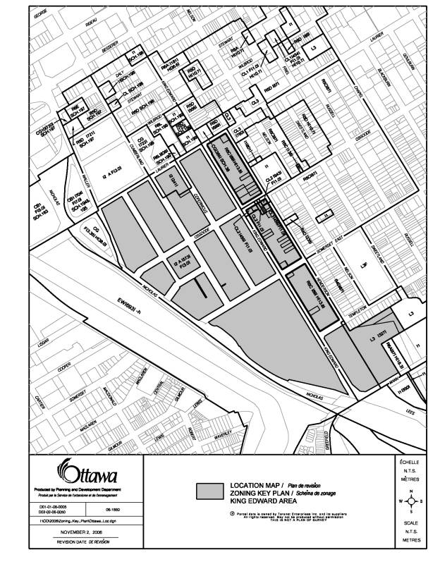
Document 1 Location Map
Document 2 Proposed
Amendment to the City of Ottawa Official Plan
Document 3 Details
of Recommended Zoning
Document 3a Zoning
Change Key Plan
Document 3b Proposed
Height Limit and Yard Set Backs
Document 3c Proposed
Heritage Overlay
Document 4 Consultation Details
DISPOSITION
Corporate Services Department, City Clerk’s
Branch, Secretariat Services to notify the owner, University of Ottawa, 141 Louis Pasteur Private, Room
230, Ottawa, Ontario, K1N 6N5, Attention: Claudio Brun del Re, the applicant, Urban Strategies Inc., Suite 600, 197 Spadina
Avenue, Toronto, Ontario, M5T 2C8, Attention: Andrea Gabor, Signs.ca, 866 Campbell Avenue, Ottawa, ON, K2A 2C5, Ghislain Lamarche,
Program Manager, Assessment, Financial Services Branch (Mail Code: 26-76) of City Council’s decision.
Planning, Transit and the Environment
Department to prepare the implementing by-law, forward to Legal Services Branch
and undertake the statutory notification.
Corporate Services Department, Legal Services
Branch to forward the implementing by-law to City Council
LOCATION MAP DOCUMENT
1
Official Plan Amendments XX/Modifications
du Plan directeur XX
To the Official Plan of the City of
Ottawa
Land use
Utilisation du sol
______________________________________________________________________________
INDEX
The Statement
Components………………………………………………………………i
PART A – THE PREAMBLE
Purpose……………………………………………………………………………………1
Location…………………………………………………………………………………..1
Basis………………………………………………………………………………………1
PART B- THE AMENDMENT
Introductory
Statement……………………………………………………………………..2
Details of the Amendment………………………………………………………………….2
THE STATEMENT OF COMPONENTS
PART A – THE PREAMBLE, introduces
the actual Amendment but does not constitute part of Amendment No. XX to the
City of Ottawa Official Plan.
PART B – THE AMENDMENT, consisting
of the following text and maps constitutes the actual Amendment No. XX to the
City of Ottawa Official Plan.
PART C – THE APPENDIX, does not form
part of the Amendment but is provided to clarify the intent and to supply
background information related to the Amendment.
PART A – THE PREAMBLE
1.0
Purpose
The purpose of Amendment No. XX is to extend
the Institutional designation, which applies to the main University of Ottawa
Campus in the Sandy Hill Secondary Plan to the properties along the east side
of King Edward Avenue and to permit a mix of institutional, commercial and
residential uses for lands designated Institutional along both sides of King
Edward Avenue. This amendment will also
eliminate any institutional uses within the residential lands along Henderson
Avenue and allow for the addition of a local commercial designation on the
north side of Osgoode Street.
In addition, Amendment No. XX will modify the
Design Control Areas to include the lands located along the east side of King
Edward Avenue, south of Laurier Avenue East to Templeton Street within the area
that is subject to Design Approval.
2.0
Location
The lands affected by this amendment
are generally located on the south side of Laurier Avenue East, east and west
of King Edward Avenue, north of Templeton Street and are known as the King
Edward Precinct.
3.0
Basis
3.1
Background
The Sandy Hill Secondary Plan of the City of Ottawa Official Plan designates the subject lands as Low Profile Residential, Local Commercial and Non-Heritage Institutional. The purpose of the policies contained in the Sandy Hill Secondary Plan is to guide future growth and change in Sandy Hill. The policies specific to the Residential designation are directed to preserving and enhancing good housing stock, locating the different types of housing in appropriate areas, and to providing a wide variety of housing. The Local Commercial designation applicable to lands along the south side of Osgoode Street between King Edward Avenue and Henderson Avenue allows for small-scale commercial uses that serve the local community. The purpose of the policies associated with the Institutional designation is to permit orderly development of the University of Ottawa and to encourage useful links with the adjacent community.
The current boundary of the Design Control Area
includes the University lands located on the west side of King Edward
Avenue. The Design Control Area allows
for a development review process for all new development within the Design
Control Area boundary.
3.2
Rational
The University intends to redevelop
their land holdings in accordance with their Master Plan for the King Edward
Precinct. The Master Plan establishes a framework to establish a seam that
provides a better integration and transition between the Main University of
Ottawa campus west of King Edward Avenue and the Sandy Hill Community east of
Henderson Avenue.
This Plan will ensure that no
institutional uses are permitted within the residential area along Henderson
Avenue, promotes a mix of uses along King Edward Avenue to serve both the University
and the residential community, promotes good infill development, and overall
will bring stability to the residential areas of Sandy Hill.
The Department is recommending that the Sandy Hill Secondary Plan of the City of Ottawa Official Plan be amended to extend the Institutional land use designation that applies to the University Campus and to broaden the scope of uses that can locate within this designation along the King Edward Corridor to provide for the evolution of King Edward Avenue into a mixed use street that will better integrate the university with the Sandy Hill residential community by allowing uses that will serve both the University and the community along their edges. The amendment will also limit uses along Henderson Avenue to residential.
In addition, the Department is
recommending that the boundaries of the Design Control Area be expanded to
include the lands to the east of King Edward Avenue. The expansion of the
existing Design Control Area will
allow for a consistent approach to ensuring high quality design for University
buildings developed along both sides of King Edward Avenue and allow for
ensuring a consistent and compatible expression for King Edward Avenue through
out the University campus that will contribute to the creation of lively places
and enhance the quality of the public realm and urban environment along King
Edward Avenue.
Rezoning
An amendment to the City of Ottawa
Comprehensive Zoning By-law is also being considered. The recommended zoning implements the proposed Official Plan
Amendment.
PART B- THE AMENDMENT
1.0
The
Introductory Statement
The Document entitled Part B- The
Amendment, consisting of the following text constitutes Amendment No. XX to the
City of Ottawa Official Plan.
2.0
Details
of Amendment
The City of Ottawa Official Plan is
hereby amended as follows:
2.1 In Volume 2-A, Schedule J
Sandy Hill Secondary Plan is amended as shown on Schedule “B” attached hereto.
2.2 In Volume I, Schedule L is
amended to include the lands on the east side of King Edward Avenue, south of
Laurier Avenue East and north of Templeton Street as shown on Schedule “C”
attached hereto.
2.3 In Volume 2-A, Sandy Hill
Secondary Plan, Policy 5.3.2 c) i) is replaced with an amended policy as
follows:
i) To permit orderly
development of the University of Ottawa, and to encourage useful links between the University and the
adjacent community, a mix of institutional, commercial, and residential uses
that will serve both the University and the adjacent residential community will
be permitted to locate along both sides of King Edward Avenue between Laurier
Avenue East and Templeton Street.
DETAILS OF RECOMMENDED ZONING REVISED
DOCUMENT 3
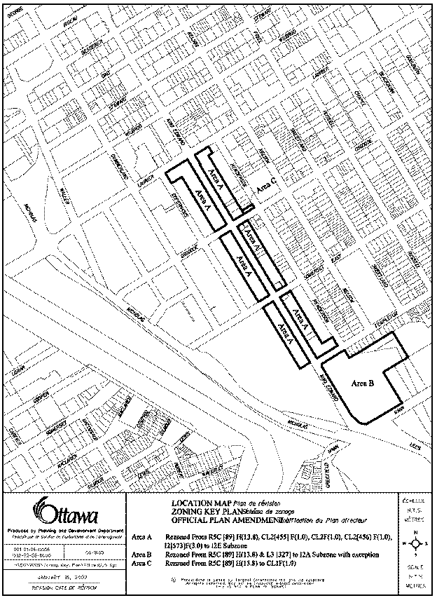
1. The lands shown on Document 3a will be rezoned as follows:
(a) Area A from R5C[89] H(13.8), CL2 [455] and I2A [573] F(3.0) to new I2E Subzones with exceptions;
(b) Area B from R5C[89] H(13.8) and L3[327] to I2A Subzone with an exception;
(c) Area C from R5C[89] H(13.8) to CL1 F(1.0).
2. The following modifications are made to the R5C[89] H(13.8), I2A[573] F(3.0) and CL2 [456] shown on Document 1:
(a) exception [89] of Table XV
of By-law 93-98 is amended by:
· deleting “- post secondary educational institution” from the list of additional uses permitted in Column II;
· adding “day care” to the list of additional uses permitted in Column II;
· deleting the fourth provision from Column IV which allows the University to distribute its permitted gross floor area over its lands; and
(b) exceptions [456] and [573] of Table XV of By-law 93-98 are amended by deleting all occurrences of the zone name “R5C[89] H(13.8)” from Column IV and by adding the new I2E subzone and associated exceptions to be established for Areas A, B as shown on Document 3a and the I2A exception zone to be established for Area C as shown on Document 3a.
3. A new I2E Subzone to be known as the University of Ottawa King Edward Precinct Zone is established with the following provisions and will apply to Area A on Document 3a:
(a) In the I2E subzone, only the following uses are permitted:
a. Institutional/Public/Community Uses
· community centre
· community health and social services centre
· cultural, social and counselling centre
· day care
· emergency services
· instructional facility
· library
· park
· place of worship
· post-secondary educational institution
· public hall
· training centre limited to job instruction or training associated with a school
· utility installation
b. Commercial Uses
· artist studio
· automated teller
· bank
· catering establishment
· club
· computer/data centre
· convenience store
· medical facility
· office
· parking garage
· parking lot
· personal service business
· recreational and athletic facility
· restaurant, full-service
· restaurant, fast-food
· restaurant take-out
· retail food store
· retail store to a maximum GFA of 2000 m2
· repair shop
· research and development centre
· small batch brewery
c. Residential Uses
· apartment building
· apartment building high-rise
· bed and breakfast
· converted house
· detached house
· diplomatic mission, official residence
· diplomatic mission, other residence
· duplex house
· dwelling unit
· fourplex house
· link-detached house
· linked townhouse
· planned unit development
· retirement home
· retirement home, converted
· semi-detached house
· stacked townhouse
· townhouse
· triplex house
(b) A maximum 50% of the total permitted gross floor area (GFA) within the I2E subzone can be occupied by residential uses. Where the gross floor area is regulated by a floor space index, the 50% maximum will be based on the total cumulative GFA permitted by the FSI within the subzone where an FSI applies and where there is no FSI, the 50% maximum will be based on the total cumulative GFA permitted based on minimum building setbacks and maximum building heights and applying a 3.2 m height from floor to floor in multi-storey buildings.
4. The following exceptions apply to the I2E subzone located on the east side of King Edward Avenue between Laurier Avenue and Templeton Street:
(a) Maximum permitted building heights and minimum yard set backs are regulated in accordance with Document 3b.
(b) The minimum separation distance between buildings shall be 1.2 metres
(c) Unless otherwise noted on Document 3b, the minimum separation distance between a building and a building lot line shall be 3.0 metres.
(d) Required parking for any uses in the I2E Subzone may be provided anywhere within Area A or Area B as shown on Document 3a or anywhere within the I2A[573] F(3.0) zone.
(e) The minimum parking rate required for an commercial uses will be the same as the parking rate for these uses located in the central area as set out in Table 51 Column III of By-law 93-98.
(f) 30% of the area of each property to be developed shall be landscaped open space, which may include a rear lane. The 30% landscaped open space requirement will be calculated at the time of building permit issuance based on the limits of the land being developed as identified on the building permit application for a proposed development.
5. The following exceptions apply to the I2E subzone located on the west side of King Edward Avenue south of Laurier Avenue East:
(a) Notwithstanding the provisions set out in Section 530, the minimum required setback for a building from a lot line adjacent to a public or private (driveway) street leading to a public street is 3.0 m.
(b) Required parking for any uses in the I2E subzone may be provided anywhere within Area A or Area B as shown on Document 3a or anywhere within the I2A[573] F(3.0) zone.
(d) The minimum parking rate required for commercial uses will be the same as the parking rate for these use located in the central area as set out in Table 51 Column III of By-law 93-98.
(e) the maximum floor space index (FSI) shall be 3.0 and this gross floor area may be distributed over any lands in the I2E subzone applying to the west side of King Edward Avenue and any lands within the I2A[573] F(3.0) zone provided that with each application for a building permit, a detailed account of the gross floor area used to date and remaining is submitted indicating that the cumulative gross floor of the two zones are not exceeded.
6. The I2A Zone applicable to Area “B” will be subject to the following exceptions:
(a) The maximum permitted height as shown on Schedule 3b.
(b) The minimum yard setbacks are as shown on Table 569 of By-law 93-98.
(c) Residential uses are prohibited.
(d) Required parking for any uses my be provided anywhere within Area A and Area B as shown on Document 3a or anywhere within the I2A [573] F(3.0) zone
7. The lands shown shaded on Document 3c are subject to a Heritage Overlay.
ZONING CHANGE KEY MAP DOCUMENT
3A
PROPOSED HEIGHT LIMIT AND YARD SET
BACKS DOCUMENT 3B
PROPOSED HERITAGE OVERLAY DOCUMENT
3C
CONSULTATION DETAILS DOCUMENT
4
NOTIFICATION AND CONSULTATION PROCESS
Notification and public consultation
was undertaken in accordance with the Public Notification and Public
Consultation Policy approved by City Council for Official Plan and Zoning
By-law amendments. Extensive public consultation was undertaken and several
public meetings were held in the community.
SUMMARY OF PUBLIC INPUT
Comments were received from the public regarding this application as a result of the public notification and as a result of the public meeting held on May 16, 2006, which was held by the Ward Councillor. Written correspondence form the Community Association was also received. The following is a summary of the concerns expressed by the community.
PUBLIC MEETING COMMENTS
On May 16, 2006 a public meeting organized by the Ward Councillor was held in the community. The following is a list of concerns followed by a response from the Department.
1. The zone change will fundamentally alter the historic look and use of the street from residential housing to a commercial block of buildings.
Response
A Heritage Impact Study
submitted with the subject application examined the effect of the proposed
development on the heritage buildings in the King Edward Precinct. Recommendation 2 f) states that a
heritage overlay be imposed for the areas as shown on Document 3c. The heritage
overlay establishes provisions specific to support building retention and to
ensure that new development will exhibit similar characteristics in terms of
built form and massing. This
recommendation will also allow Henderson Avenue to be stabilized and strengthened
as a residential street and protect specific buildings, such as 190 Laurier
Avenue and 613-615 King Edward Avenue
2. The proposed height is not in keeping with the
existing buildings along Henderson Avenue.
Response
The proposed height along King Edward
Avenue varies from 13.8 metres to 26 metres with the majority of the lands
abutting residential on Henderson Avenue being 17 metres or 21 metres. Staff is of the opinion that the proposed
height is acceptable, as sufficient separation will exist between the rear of
the future developments along King Edward Avenue and the existing buildings
along Henderson Avenue to mitigate any potential impact on the existing
residential community.
3.
I
object to the increase in height especially at the corners of King
Edward/Somerset and King Edward/Templeton Street and King Edward/Osgoode
Street. The proposed height is not
sensitive to the character of the residential area.
Response
The Department is recommending
increased height at these three locations, as they are located at the corner of
two streets, with King Edward Avenue being an arterial. It is anticipated that larger buildings at
these locations will help create focal points of development with minimal
impact on the residential community.
4. No commercial uses should be permitted along Templeton Street. The Sports Complex already encroaches onto the residences located along Templeton Street.
Response
The proposed zoning will allow for a range of residential and commercial uses at the corner of King Edward Avenue and Templeton Street and Henderson Avenue and Templeton Street. It is staff’s opinion that the small scale of the commercial component will serve the residential community as well as the university students.
5. I would like a condition to be imposed regarding the visual appearance and the noise generated by ventilation systems. In addition, the location of the garbage containers is of a concern and the noise generated by the garbage being picked up from these institutional buildings.
Response
Issues related to the location of the mechanical or ventilation equipment, and the screening of garbage storage areas are matters, which cannot be addressed through the Zoning Amendment and Official Plan Amendment process. However, these issues will be discussed and finalized during the Site Plan Control process that all new development will be subject to.
4. Existing traffic conditions are a concern. This proposal will only add to the problem.
Response
The area is well served by bus and rapid transit services and pedestrian circulation patterns are well established in the area. The Department is satisfied that the traffic impact on the abutting residential streets will be minimal as the proposed uses are of a scale that will not attract large volumes of vehicular traffic from outside the immediate area. In addition, vehicular access to on-site parking will be accessed via a private lane located parallel to King Edward Avenue. The details of the proposed zoning will also allow parking to occur on other properties owned by the University such as the Sports Complex located to the south of the residential community.
5. The design of the building on Laurier is atrocious.
Response
Recommendation 1d) recommends that the lands located along the east side of King Edward Avenue be subject to the Design Review process. This will ensure high quality design for University buildings developed on the east side of King Edward Avenue.
6. This application will be rubber-stamped. Will the community be involved in the development review process?
Response
The community has played a large role in the development review process. The King Edward Precinct Strategy, a component of the University of Ottawa’s updated Master Plan, was developed through a consultative process, which involved the residents of Sandy Hill, local business owners, and other stakeholders. A public meeting was also held in the community to discuss the proposal. The community and Action Sandy Hill will continue to be involved and notified as development applications are submitted to the City of Ottawa.
7. There is a lack of open space in the proposal.
Response
The details of the proposed zoning requires that 30% of lands being developed be landscaped open space, which can include a private lane running parallel to King Edward. The 3.0 metre building set back proposed along King Edward Avenue will provide a consistent landscape buffer along the street edge. Further details of the landscape open space will be addressed during the Site Plan Control Approval process.
8. We are concerned regarding the sewer capacity and the impact of the proposal on the existing services.
Response
A Servicing Study was prepared to
respond to servicing concerns expressed by the community. The study examined the existing water
distribution system, and the existing storm and sewer conditions. Redevelopment
of the subject properties in the future will provide for an opportunity to
reduce and manage stormwater runoff and therefore reduce flooding issues and
sewer surcharging occurring primarily to the south of the King Edward Precinct.
Further detailed servicing studies will be required as part of the Site Plan
Control Approval process, when these development applications are submitted to
the City for approval.
9. We have an issue with housing in the neighbourhood and the disturbances caused by these tenants.
Response
The University is working with the residential community, the Student Association and the City of Ottawa to address and mitigate disturbances caused by certain residents on University property.
10. The University does not do a good job of preserving the buildings in the area.
Response
The University is aware of the community’s concerns regarding the maintenance of their buildings. Repairs and relocation of buildings will be done in accordance with the King Edward Precinct Strategy, Heritage Impact Component.
11. We are not confident that the University will proceed in an orderly development on Henderson Avenue or King Edward.
Response
While this report deals with establishing a development framework, the actual development of the properties along King Edward will be subject to further development approval processes such as Site Plan Control approval and Design Review approval. These future processes will help provide orderly development.
12. Concerns regarding the functioning of the existing sports complex. There have been only negative impact to sun and air and no contribution to the overall physical environment. Therefore there will be no guarantees that the proposed developments will improve the community.
Response
Proposed developments along King Edward Avenue will be subject to public notification, which will include notification to Action Sandy Hill. The community will be encouraged to provide comments relating to the Site Plan Control applications.
13. I am pleased that the City is not entertaining a zoning change on Templeton Street.
Response
No changes are proposed to the residential properties located on the south side of Templeton Street.
14. We are concerned with the sun/shadow impact that the proposed building will have on our property.
Response
The applicant undertook a sun/shadow study to assess the potential impacts associated with the building height proposed for the properties along King Edward Avenue. The study originally included a proposed height of 29 metres, which has since been reduced to 26 metres. The study shows that the impacts associated with the proposed building heights will have minimal impact on the adjacent properties.
15. This application should not be considered until the Heritage Study is completed.
The Heritage Study for the Sandy Hill Area will not be finalized for another two years. The Department is required under the Planning Act to render a decision within 120 days of the receipt of Official Plan Amendment and rezoning applications.
COUNCILLOR’S COMMENTS
Councillor Georges Bédard is aware of the application.
COMMUNITY ORGANIZATION COMMENTS
Action Sandy Hill
Action Sandy Hill indicated that they were pleased with the changes to lower the building height in question from 29 metres to 26 metres. However, Action Sandy Hill will like to continue to be involved in the Site Plan Control Approval process to address concerns regarding open space, set backs, heritage and building design.
Response
The Zoning By-law amendment application will set out the parameters regarding the set backs and landscaped open space. The details of these performance standards will be addressed during the Site Plan Control Approval process. Action Sandy Hill will be notified of future site plan applications as soon as they are received by the City and will be invited to provide comments on these applications. Recommendation 1b) will require that any development along King Edward Avenue be subject to the review of the Design Approval Committee. In addition, Recommendation 2h) will impose an heritage overlay for the properties as shown on Document 3c.
Sandy Hill Housing Co-op
”Sandy Hill Housing Co-op withdraws its previously filed objection to the rezoning application on the following conditions:
- That the proposed height of 29 metres at the corner of King Edward Avenue and Templeton Street be reduced to 26 metres.
- That there be a rear yard setback of 6.5 metres from the middle of the block for the buildings fronting King Edward Avenue between Templeton Street and Somerset Street East,
- That the existing conditions and building setbacks along Henderson Avenue between Somerset Street East and Templeton Street be continued.”
Response
The proposed 29-metre height has been reduced to 26 metres and a 6.5 metre set back will be required for the block bounded to the north by Somerset Street East and to the south by Templeton Street. No changes are proposed to the existing zoning pertaining to building height and yard set backs along Henderson Avenue.