|
2. OFFICIAL
PLAN - 870, 886, AND PART OF 910 MARCH ROAD, 1001 AND PART OF PLAN OFFICIEL - 870, 886,
ET PARTIE DE 910, CHEMIN MARCH, 1001 ET PARTIE DE 1045, CHEMIN KLONDIKEZONAGE
– Partie de 1001, chemin Klondike |
Committee recommendationS
That Council:
1. Approve and adopt an amendment to the
Official Plan to redesignate 870, 886, and part of 910 March Road, 1001 and
part of 1045 Klondike Road from Enterprise Area to General Urban Area, with a
site-specific provision as detailed in Document 3; and
2. Approve an amendment to the former City
of Kanata Zoning By-law 164-93 to change the zoning of part of 1001 Klondike
Road from R5A-4 (Residential Type 5A-Exception) to R3A-2 (Residential Type 3A--Exception),
as shown in Document 2, and detailed in Document 4.
RecommandationS du Comité
Que le Conseil municipal :
1. Approuve et adopte une modification au
Plan officiel de manière à faire passer la désignation des 870, 886 et d'une
partie du 910, chemin March, du 1001 et d'une partie du 1045, chemin Klondike
de Zone d'entreprises à Zone urbaine générale, accompagnée d'une disposition
propre à l'emplacement, tel qu'exposé dans le document 3;
2. Approuve une modification au Règlement
de zonage 164-93 de l'ancienneVille de Kanata, de manière à faire passer le
zonage d'une partie du 1001, chemin Klondike de R5A-4 (Résidentiel de type
5A--Exception) à R3A-2 (Résidentiel de type 3A-Exception), tel qu'illustré dans
le document 2 et exposé en détail dans le document 4
Documentation
1.
Deputy
City Manager's report Planning,
Transit and the Environment dated
27 March 2007 (ACS2007-PTE-APR-0098).
Report
to/Rapport au :
Planning and Environment Committee
Comité de l'urbanisme et de l'environnement
27 March 2007 / le 27 mars 2007
Submitted by/Soumis par Nancy Schepers, Deputy City Manager/
Directrice municipale adjointe
Planning, Transit and the Environment/ Urbanisme, Transport en commun
et Environnement
Contact
Person/Personne Ressource : Grant Lindsay, Manager / Gestionnaire,
Development Approvals / Approbation des demandes d'aménagement
(613)
580-2424, 13242 Grant.Lindsay@ottawa.ca
REPORT
RECOMMENDATIONS
That the Planning and Environment Committee
recommend City Council:
1. Approve and adopt an amendment to the
Official Plan to redesignate 870, 886, and part of 910 March Road, 1001 and
part of 1045 Klondike Road from Enterprise Area to General Urban Area, with a
site-specific provision as detailed in Document 3; and
2. Approve
an amendment to the former City of Kanata Zoning By-law 164-93 to change the
zoning of part of 1001 Klondike Road from R5A-4 (Residential Type 5A-Exception)
to R3A-2 (Residential Type 3A--Exception), as shown in Document 2, and detailed
in Document 4.
RECOMMANDATIONS DU
RAPPORT
Que le Comité de l’urbanisme et de l’environnement
recommande au Conseil municipal :
1. D'approuver
et d'adopter une modification au Plan officiel de manière à faire passer la
désignation des 870, 886 et d'une partie du 910, chemin March, du 1001 et d'une
partie du 1045, chemin Klondike de Zone d'entreprises à Zone urbaine générale,
accompagnée d'une disposition propre à l'emplacement, tel qu'exposé dans le
document 3;
2. D'approuver
une modification au Règlement de zonage 164-93 de l'ancienneVille de Kanata, de
manière à faire passer le zonage d'une partie du 1001, chemin Klondike de R5A-4
(Résidentiel de type 5A--Exception) à R3A-2 (Résidentiel de type 3A-Exception),
tel qu'illustré dans le document 2 et exposé en détail dans le document 4
BACKGROUND
Site
Description
The lands
subject to these applications are located north of Klondike Road, east of March
Road, west of the Ottawa Central Railway, and south of the Urban Boundary. The lands are currently being developed as
the Brookside Subdivision, which was Draft Approved in August 2005. Surrounding uses include existing
residential development and undeveloped lands along March Road to the west,
rural uses to the north, the Ottawa Central Railway and undeveloped lands to
the east, and the partially developed Briar Ridge residential subdivision to
the south.
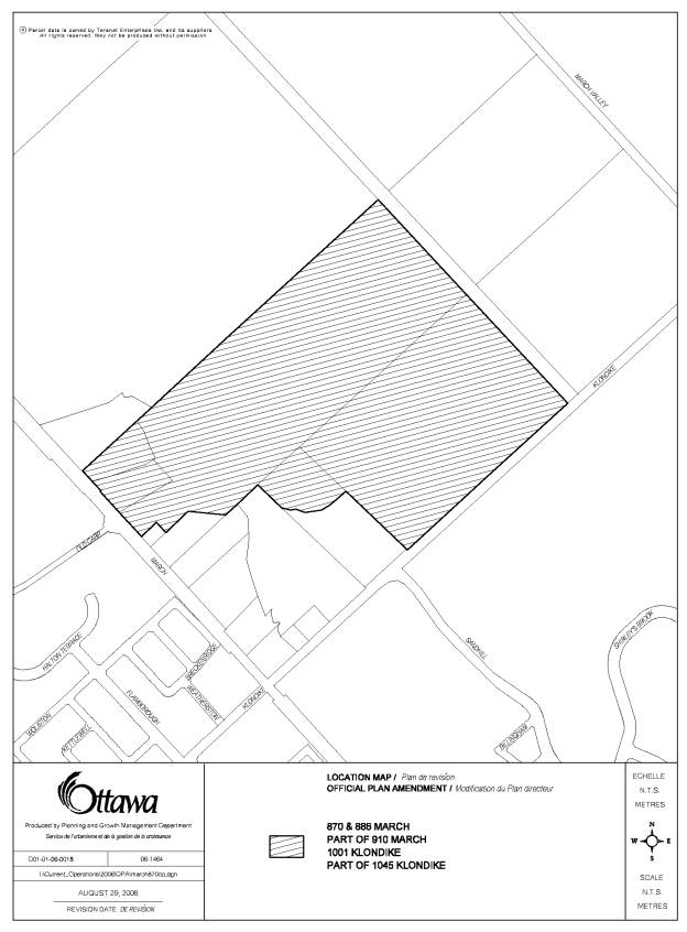
The site
subject to the Official Plan amendment (870, 886, and part of 910 March Road,
1001 and part of 1045 Klondike Road) is approximately 45.9 hectares, and
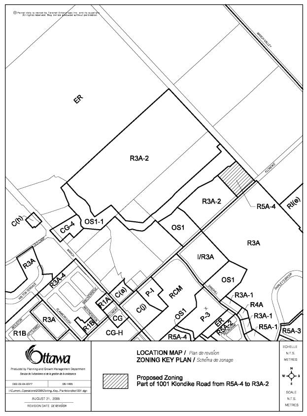
represents the entirety of the Draft Approved Subdivision (Document 1). The site subject to the Zoning By-law
amendment (Part of 1001 Klondike Road) is 1.5 hectares and is located in the
extreme southeast corner of the Draft Approved Subdivision (Document 2). The site subject to the Zoning By-law
amendment is also subject to the Official Plan amendment.
Purpose of
Applications
The
purpose of these applications is to permit development to occur on the lands
shown in Document 2 at a lower density than is currently required by the
Official Plan and Zoning By-law, specifically to permit the development of
semi-detached and townhouse dwelling units.
Site
History
The
subject lands were added to the Urban Area in 1997 following the recommendations
of the Kanata North Urban Expansion Study (KNUES), which had been ongoing since
the early 1990s. Subsequent Regional
and Kanata Official Plan Amendments were approved by Council in 2000
designating the subject lands as residential, however, this decision was
appealed by then owners of the lands, Kanata Research Park Corporation (KRPC),
and the designation was subsequently amended to Business Park. In 2002, an application submitted by KRPC
was approved further amending the Regional and Kanata Official Plans, this time
to permit residential development within the Business Park designation.
The
approval of these Official Plan amendments included site-specific provisions,
most notably, a requirement for a minimum net residential density of
35 units per hectare.
The new
Official Plan was adopted by City Council in May 2003, and it designated the
subject lands as Enterprise Area. The
designation also included the site-specific provision requiring a minimum
density of 35 units per hectare for residential development, which was carried
over from the Regional and Kanata Official Plans.
An
application for a residential plan of subdivision for the subject lands was
submitted in May of 2004. The initial
Demonstration Plan submitted by the applicant showed a plan of subdivision that
met the minimum density of 35 units per hectare with a mix of single-detached,
semi-detached, townhouse, and stacked townhouse dwellings. During the subdivision review process, the layout
of the subdivision underwent several changes, reflecting responses to various
comments and concerns expressed by staff, the public, and other technical
agencies.
At the
same time, City staff were also in the process of preparing a City-initiated
Official Plan amendment intended to deal with some of the appeals on the
approved Official Plan. As part of this
proposed Official Plan amendment, staff recommended that the designation of
several lands throughout the city, including the subject lands, be changed from
Enterprise Area to General Urban Area, and thereby removing the minimum
residential density requirement for these lands. The applicant changed the plan of subdivision layout and density
to align with the proposed City-initiated redesignation of the subject lands to
General Urban Area. City Council
approved the Official Plan amendment, but decided not to include the
redesignation of the subject lands.
As a
result, the lands remained designated as Enterprise Area and the applicant was
still required to meet the minimum net density requirement of 35 units per
hectare. Since the layout of the
subdivision had undergone extensive changes since it was originally proposed,
the subdivision could no longer accommodate the required density in its latest
configuration. Accordingly, a 1.5-hectare
block within the subdivision (Document 2) was proposed for apartment dwelling
units with an increased minimum density of 89 units per hectare, thereby
allowing the overall subdivision to meet the 35 units per hectare average
minimum density requirement. The
applicant proceeded with the subdivision on this basis. The plan of subdivision was draft approved
by staff in August 2005, and the implementing Zoning By-law amendment was
adopted by City Council in July 2006.
In August
2006, the applicant submitted Official Plan and Zoning By-law amendment
applications that are the subject of this report. These applications are requesting to change the designation of
the site from Enterprise Area to General Urban Area, as well as change the
zoning on a portion of the site from R5A-4 to R3A-2. The applicant intends to develop the lands shown in Document 2 at
a lower density than that which is currently required in the Zoning By-law.
DISCUSSION
Policy
Framework
The site
is designated as Enterprise Area in the Official Plan. This designation permits employment uses and
a variety of complementary uses, such as service commercial. Residential uses are permitted in the Enterprise
Area subject to an amendment to the Zoning By-law. As described above, there is a site-specific policy within the
Enterprise Area policies specifying a minimum density requirement of 35 units
per hectare on the site. This
site-specific policy does not apply to lands designated General Urban
Area. If the proposal to change the
Official Plan designation from Enterprise Area to General Urban Area is
approved, this site-specific policy will no longer apply to the subject
lands.
Zoning
By-law
The site
is zoned as R5A-4 (Residential Fifth Density Zone--Exception), which permits
apartment dwellings only at a minimum density of 89 units per hectare. The proposed zoning is R3A-2, which will
permit townhouse residential development with no minimum density. Official Plan policy 2.2.3.6 specifies that
proposals “to amend the zoning by-law within urban areas to eliminate
residential apartments as a permitted use, or to change the permitted use so
that the effect is to down-zone a site, will not be permitted unless there is
an equivalent rezoning to ensure no net loss of apartment potential or
maintenance of unit yield potential through other forms of multiple-unit
housing.” The proposed rezoning will
eliminate apartment units and reduce the minimum density on the lands shown in
Document 2, which conflicts with this policy.
A site-specific Official Plan amendment (OPA) is required in order to
exempt these lands from policy 2.2.3.6 and to allow the rezoning to proceed.
Accordingly, this proposal consists of three amendments, including:
(1) Official Plan amendment to change the designation of the lands shown in Document 1 from Enterprise Area to General Urban Area; (2) Official Plan Amendment to add a Site-Specific Policy to exempt the lands shown in Document 2 from Official Plan policy 2.2.3.6; and (3) Zoning By-law amendment from R5A-4 to R3A-2. These amendments are ordered such that OPA (1) is required in order to allow OPA (2) to proceed, and OPA (1) and (2) are both required in order for the Zoning By-law to proceed. Staff support both Official Plan amendments and the Zoning By-law amendment, the rationale for which will be examined in detail following.
Rationale
(1) Official Plan Amendment: Enterprise Area to General Urban Area
Removal of Enterprise Area Lands
As described in the Site History section above, the subject lands were originally proposed for residential uses when they were added to the Urban Area from 1997 to 2000. The designation was changed to permit employment uses at the request of the landowner. The new Official Plan retained the employment designation on these lands.
As part of a 2005 City-initiated Official Plan amendment, staff recommended that the designation of these lands be changed from Enterprise Area to General Urban Area. Staff concluded that the removal of these lands from the Enterprise Area would not impact the availability of employment lands throughout the city. Although City Council approved the majority of the Official Plan amendment, they did not approve the removal of these particular lands from the Enterprise Area designation. Since that time, these lands and other adjacent Enterprise Area lands have not developed for employment uses.
The proposed General Urban Area designation permits residential uses, as well as conveniently located employment, retail, service, cultural, leisure, entertainment and institutional uses. Since the lands developed as predominantly residential, the General Urban Area designation is the most appropriate designation to direct the future development of compatible uses.
Staff are currently preparing a City-wide Employment Strategy to examine the supply of employment land for the entire city. This strategy will help inform the 2008 Official Plan review, which will include recommendations for potential changes to the amount of lands designated as Employment and Enterprise Area. The employment lands that are proposed to be eliminated through the Official Plan amendment as shown on Document 1 will be accounted for during the comprehensive review of all employment lands throughout the city.
Minimum Density
The site-specific
minimum density requirement required under the Enterprise Area for these lands
was a result of an amendment to the former Kanata and Regional Official
Plans. The purpose of the OPA was to
enhance the mix of employment, commercial and recreation uses present in a
business park. The minimum density
requirement was intended to: (1) maximize the intensity of residential
development on those lands that are developed as such, so that land would still
be available for employment uses, (2) allow more land to be preserved for
natural features, and (3) allow residential uses to develop at a density that
would support public transit use, cycling and walking as viable modes of
transport. However, the lands did not
develop with the intended land use mix, and instead were developed as a
completely residential subdivision with no lands maintained for employment
uses.
The draft approved subdivision, as well as the proposed development, do preserve natural features of the land, such as Shirley's Brook, and have been developed in such a way that they are conducive to walking, cycling, and transit use. In this way, the intent of the minimum density requirement has been satisfied. The net density for the entire site including the proposed development would be 30 units per hectare, which is comparable to the original density requirement of 35 units per hectare. Furthermore, the Official Plan calls for net residential densities of 29 units per hectare in Developing Communities. A Developing Community is an undeveloped greenfield area within the Urban Boundary, where future urban development is envisioned.
(2) Official Plan
Amendment: Addition of Site Specific Policy
Adjacent Lands
The intent of Official Plan policy 2.2.3.6 is to maintain the unit and apartment potential in the area. Within the immediate area (bound by Klondike Road, March Road, the Urban Boundary, and the Ottawa Central Railway), there exists approximately 9.5 hectares of undeveloped urban lands, which all directly abut this subdivision. Because these adjacent lands have not yet been developed, they have the ability to accommodate the density and apartment potential lost through the proposed rezoning. These adjacent sites are well suited to potential intensification, since these lands are either closer to, or directly front onto March Road, which is an arterial road. The Official Plan indicates that lands adjacent to arterial roads should be the focus of intensification in order to make use of the existing services and infrastructure available along these types of roads. March Road has been identified for higher-order transit, and has been identified through the EA process as one of the preferred routes for the East-West LRT. It should be noted that the site known as 830-910 March Road is currently also the subject of Official Plan and Zoning By‑law amendments to change the designation from Enterprise Area to General Urban Area for the purpose of permitting a retail development. It is staff’s intent to recommend that residential uses be included as an additional permitted use on these lands. This will contribute toward balancing the loss of density or apartment potential through this proposal.
Housing Mix
The site is proposed for the development of Adult Lifestyle units in the form of single-storey townhouses and semi-detached dwellings. The General Urban Area “permits the development of a full range and choice of housing types to meet the needs of all ages, incomes and life circumstances.” Adult Lifestyle units represent a unique type of dwelling unit that satisfies the Official Plan's intent for a mix of housing types. This particular type of Adult Lifestyle dwelling units have special characteristics that reflect the needs of the projected users, such as a single-storey building form. Staff recognize that low-rise building form cannot achieve the level of density that is currently required in the Zoning By-law, and the proposed use satisfies the policy for a mix of housing types.
Compatibility
The evaluation of development applications, studies, other plans and public works undertaken by the City in the General Urban Area will be in accordance with Section 2.5.1 and Section 4.11 (Compatibility) of the Official Plan. Although the Official Plan does allow for medium-density uses such as low-rise apartments or stacked townhouses in locations such as these, the proposed low-density development is also compatible with the surrounding uses. The proposed development sites two-storey townhouses fronting onto Klondike Road, which are of similar form to the townhouses that have been approved in the adjacent development on the south side of Klondike Road. Single-storey adult lifestyle townhouse dwellings are proposed adjacent to Shirley’s Brook, which provide a sensible transition between the natural area in the Shirley’s Brook corridor and the two-storey townhouses abutting to the south. The proposed development is considered to be compatible with the surrounding forms of development.
(3) Zoning By-law
Conformity with Official Plan
The proposed R3A-2 zone has no minimum or maximum density provisions. The density of the proposed development on the lands shown on Document 2 is approximately 23 units per hectare. If the Official Plan amendments above were approved, there would no longer be any minimum density required by the Official Plan policies. The proposed rezoning conforms with the proposed Official Plan designation and site-specific policy as described in detail above.
Zone Provisions
The R3A (Residential Type 3A) zone provisions are standard throughout northern Kanata. An exception zone (R3A-2) was created for the Brookside subdivision to address site-specific issues such as setback, lot coverage, parking, and amenity area. The same provisions are applicable to this phase of the Brookside subdivision. A subsequent Plan of Subdivision and Site Plan Control application will be required to be approved prior to development of these lands, and these application processes will address compatibility issues such as lot configuration, street location and access, form, massing, and buffering.
Summary
Staff support the proposal to change the designation of the lands shown in Document 1 from Enterprise Area to General Urban Area. The removal of the subject lands from the Enterprise Area designation is not expected to impact the short-term supply of employment lands in the city. The General Urban Area is a more appropriate designation for the lands, and that the intent of the minimum density provision will be maintained by the proposed development.
Staff support the proposal to add a site-specific policy to section 2.2.3 of the Official Plan to exempt the lands shown in Document 2 from policy 2.2.3.6. It is evident that adjacent lands are capable of accommodating the density lost via this proposal. The type of housing proposed contributes to creating a desirable mix of housing in the area, and the proposed development is compatible with surrounding uses.
Staff support the proposal to change the zoning of the lands shown in Document 2 from R5A-4 to R3A-2 because the proposal is compatible with the proposed Official Plan policies, and the proposed zone provisions adequately guide development of these lands.
Staff recommend approval of the Official Plan Zoning By-law amendments to permit the development of semi-detached and townhouse dwellings.
ENVIRONMENTAL IMPLICATIONS
The effect of the proposed Official Plan and
Zoning By-law amendments would be to permit residential development on the site
at a density lower than that currently permitted. Staff have determined that the density removed from the subject
lands could be readily accommodated on adjacent undeveloped lands, and thus the
impact on the rest of the urban area is minimal.
The site is within the Urban Boundary and directly abuts the Rural Area. There are no expected impacts on the rural area as a result of the proposed Official Plan and Zoning By-law amendments.
CONSULTATION
Notice of this application was carried out in accordance with the City's Public Notification and Consultation Policy. The Ward Councillor is aware of this application and the staff recommendation. Comments were received from the March Rural Community Association and the Briarbrook and Morgan’s Grant Community Association. The issues raised can be summarized as follows:
· Apartment units provide a mix of housing types.
· Increased density can provide greater greenspace.
The complete Community Association comments are attached in Document 5 Consultation Details.
FINANCIAL IMPLICATIONS
N/A
APPLICATION PROCESS TIMELINE STATUS
This application was not processed by the "On Time Decision Date" established for the processing of Official Plan amendments due to issues with the proposed Zoning By-law amendment.
SUPPORTING DOCUMENTATION
Document 1 Location Map-Official Plan Amendment
Document 2 Location Map-Zoning By-law Amendment
Document 3 Proposed Official Plan Amendment
Document 4 Details of Recommended Zoning
Document
5 Consultation Details
DISPOSITION
Corporate Services Department, City Clerk’s
Branch, Secretariat Services to notify the owner, (attn: Mark Purchase,
Klondike Development Inc, 9094 Highway #7, R.R.#2 Ashton, ON K0A 1B0),
applicant, (Greg Winters, Novatech
Engineering Consultants Ltd, Suite 200, 240 Michael Cowpland Drive, Ottawa, ON
K2M 1P6), OttawaScene.com, 174 Colonnade Road, Unit #33, Ottawa, ON K2E 7J5,
Ghislain Lamarche, Program Manager, Assessment, Financial Services Branch (Mail
Code: 26-76) of City Council’s
decision.
Planning, Transit and the Environment Department to prepare the by-law adopting the Official Plan Amendment, and the implementing Zoning By-law, forward to Legal Services Branch, and undertake the statutory notification.
Corporate Services Department, Legal Services
Branch to forward the implementing by-law to City Council
LOCATION MAP—OFFICIAL PLAN
AMENDMENT DOCUMENT 1
LOCATION MAP—ZONING
BY-LAW AMENDMENT DOCUMENT 2
PROPOSED OFFICIAL PLAN AMENDMENT DOCUMENT
3
|
|

Official Plan Amendment
__ Modifications du Plan directeur
To the Official Plan of the City of Ottawa
Land use
Utilisation du sol
INDEX
THE STATEMENT OF COMPONENTS
PART A – THE PREAMBLE does not constitute part of the Amendment.
Purpose
Location
Basis
PART B – THE AMENDMENT consisting of the following text constitutes Amendment. No. __ to the City of Ottawa Official Plan (2003).
Introduction
Details of the Amendment
Implementation and Interpretation
Schedule A of Amendment __ – Official Plan of the City of Ottawa
PART A – THE PREAMBLE
Purpose
The purpose of this amendment is to amend Schedule B (Urban Policy Plan), Annex 6, (Secondary Plans and Site-Specific Policies), and to add text to Section 2.2.3 (Managing Growth Within the Urban Area) to permit residential development at a lower density than is currently required by the plan.
Location
The lands subject to this amendment are known municipally as 870, 886, and part of 910 March Road, 1001 and part of 1045 Klondike Road, and described as Part 1 on Plan 5R-14250, Part 1 on Plan 5R-1444, Part 1 on Plan 4R-7887, Part 1 on Plan 4R-7878, Part 2 on Plan 4R-21477, Part of Lot 11, Concession 4, Geographic Township of March, and shown in Schedule A to this amendment. The lands are located east of March Road, south of the Urban Boundary, west of the Ottawa Central Railway, and north of Klondike Road.
Basis
Background
The Official Plan amendment application proposes to: (1) amend the City of Ottawa Official Plan designation on the site from Enterprise Area to General Urban Area, and (2) create a site-specific exemption from Official Plan Policy 2.2.3.6.
The purpose of this application is to permit development to occur on the lands at a lower density than is currently required by the Official Plan and Zoning By-law, specifically to permit the development of semi-detached and townhouse dwelling units.
Context of Amendment
The site is designated as Enterprise Area in the Official Plan. This designation permits employment uses and a variety of complementary uses, such as service commercial. Residential uses are permitted in the Enterprise Area subject to a Zoning By-law amendment. As described above, there is a site-specific policy within the Enterprise Area policies specifying a minimum density requirement of 35 units per hectare on the site. This site-specific policy does not apply to lands designated General Urban Area.
The site is zoned as R5A-4 (Residential Fifth Density Zone--Exception), which permits apartment dwellings only at a minimum density of 89 units per hectare. The proposed zoning is R3A-2, which will permit townhouse residential development with no minimum density. Official Plan policy 2.2.3.6 specifies that proposals “to amend the zoning by-law within urban areas to eliminate residential apartments as a permitted use, or to change the permitted use so that the effect is to down-zone a site, will not be permitted unless there is an equivalent rezoning to ensure no net loss of apartment potential or maintenance of unit yield potential through other forms of multiple-unit housing.”
The proposed rezoning will eliminate apartment units and reduce the minimum density on the lands shown in Document 2, which conflicts with this policy. A site-specific Official Plan amendment is required in order to exempt these lands from policy 2.2.3.6 and to allow the rezoning to proceed.
The subject lands were originally proposed for residential uses when they were added to the Urban Area between 1997 and 2000. The designation was changed to permit employment uses only at the request of the landowner. As part of a 2005 City-initiated Official Plan amendment, staff recommended that the designation of these lands, along with some other lands throughout the city, be changed from Enterprise Area to General Urban Area. The removal of these lands from the Enterprise Area was not expected to impact the availability of employment lands throughout the city. Although City Council approved the majority of the OPA, they did not approve the removal of these particular lands from the Enterprise Area designation. Since that time, these lands and other adjacent Enterprise Area lands have not developed for employment uses.
The removal of the subject lands from the Enterprise Area will not adversely affect the short-term availability of employment lands in the city, while long-term employment land availability will be addressed through an ongoing Employment Strategy to be prepared by staff. Furthermore, there has been clear direction in the past to have these lands develop primarily for residential uses.
Changing the designation of the lands to General Urban Area will reflect the fact the lands have developed as predominantly residential despite the intent of the applicable Official Plan policies, and now cannot realistically accommodate employment uses as originally envisioned. The proposed General Urban Area designation permits residential uses, as well as conveniently located employment, retail, service, cultural, leisure, entertainment and institutional uses. Thus, the proposed land use designation will still permit employment uses, in addition to other uses, with the intent of creating communities that meet all of the daily needs of its residents. It is recognized that the lands have developed as primarily residential uses. The proposed Official Plan amendment will still allow the integration of some limited mix of uses as per the policies of the General Urban Area.
The site-specific minimum density requirement was intended to: (1) maximize the intensity of residential development on those lands that are developed as such, so that land would still be available for employment uses, (2) allow more land to be preserved for natural features, and (3) allow residential uses to develop at a density that would support public transit use, cycling and walking as viable modes of transport. However, the lands did not develop with the intended land use mix, and instead were developed as a completely residential subdivision with no lands maintained for employment uses. The proposed development has been designed such that it will consider natural features, such as Shirley's Brook, and will be developed in such a way that it is conducive to walking, cycling, and transit use. The net density for the entire site based on the concept plan presented to staff, would be 30 units per hectare, which is comparable to the original density requirement of 35 units per hectare. Furthermore, the Official Plan calls for net residential densities of 29 units per hectare in Developing Communities, which are similar undeveloped greenfield communities.
The proposal will satisfy the intent of the minimum density requirement, and the proposed density will be consistent with that envisioned for other newly developing areas of city.
The intent of Official Plan policy 2.2.3.6 is to maintain the unit and apartment potential in the area. Within the immediate area (bound by Klondike Road, March Road, the Urban Boundary, and the Ottawa Central Railway), there exists approximately 9.5 hectares of undeveloped urban lands, which all directly abut this subdivision. Because these adjacent lands have not yet been developed, they have the ability to accommodate the density and apartment potential lost through the proposed rezoning. These adjacent sites are well suited to potential intensification, since these lands are either closer to, or directly front onto March Road, which is an arterial road. The Official Plan indicates that lands adjacent to arterial roads should be the focus of intensification in order to make use of the existing services and infrastructure available along these types of roads. This will contribute toward balancing the loss of density or apartment potential through this proposal.
The site is proposed for the development of Adult Lifestyle units in the form of single-storey townhouses and semi-detached dwellings. The General Urban Area “permits the development of a full range and choice of housing types to meet the needs of all ages, incomes and life circumstances.” Adult Lifestyle units represent a unique type of dwelling unit that satisfies the Official Plan's intent for a mix of housing types, but have characteristics that prevent it from achieving higher densities.
Although the Official Plan does allow for medium-density uses such as low-rise apartments or stacked townhouses in locations such as these, the proposed low-density development is also compatible with the surrounding uses. The proposed development sites two-storey townhouses fronting onto Klondike Road, which are of similar form to the townhouses that have been approved in the adjacent development on the south side of Klondike Road. Single-storey adult lifestyle townhouse dwellings are proposed adjacent to Shirley’s Brook, which provide a sensible transition between the natural area in the Shirley’s Brook corridor and the two-storey townhouses abutting to the south. Clearly, the proposed development is compatible with the surrounding forms of development.
Rezoning
An amendment to the former City of Kanata Zoning By-law is also being reviewed at this time. The recommended zoning complements the Official Plan designation presented and provides the ability to implement the policies presented.
PART B – THE AMENDMENT
1. Introduction
All of this part of this document entitled Part B – The Amendment consisting of the following text and the attached Schedule A constitutes Amendment No. __ to the Official Plan of the City of Ottawa.
2. Details
The following changes are hereby made to the Official Plan of the City of Ottawa:
2.1
Volume 1, Schedule B, Urban Policy Plan is amended so
that the lands known municipally as 870,
886, and part of 910 March Road, 1001 and part of 1045 Klondike Road,
and described as Part 1 on Plan 5R-14250, Part 1 on Plan 5R-1444, Part 1 on
Plan 4R-7887, Part 1 on Plan 4R-7878, Part 2 on Plan 4R-21477, Part of Lot 11,
Concession 4, Geographic Township of March, and as shown in Schedule 1 of this
amendment, are re-designated from “Enterprise
Area” to “General Urban Area”.
2.2 Volume 1, Annex 6, Secondary Plans and Site Specific Policies is amended to delete the northernmost of the two areas labelled “Area G”.
2.3 Section 2.2.3, Managing Growth Within the Urban Area, is amended to add the following text after policy (9):
“10. Notwithstanding the above, policy 6 does not apply to the lands known municipally as part of 1001 Klondike Road.”
3. Implementation and Interpretation
Implementation and interpretation of this Amendment shall be in accordance with the policies of the City of Ottawa Official Plan (2003).
SCHEDULE A

DETAILS OF RECOMMENDED ZONING DOCUMENT 4
The City of Kanata Zoning
By-law 164-93 as amended, is hereby amended as follows:
- Schedule
“A” of the By-law shall be amended such that the zoning on the lands known
municipally as part of 1001 Klondike Road and shown on Document 2, is to
be changed from R5A-4 (Residential Type 5A Zone—Exception 4) to R3A-2
(Residential Type 3A Zone—Exception).
- Delete
the second occurrence of clause 7(3)(d), which states:
“R5A-4
Despite
any provisions to the contrary the following applies to the lands zoned R5A-4:
(i)
subclause 7(2)iv)(k) does not apply and the minimum density for an APARTMENT
DWELLING is 89 units per hectare.”
CONSULTATION DETAILS DOCUMENT
5
COMMUNITY ORGANIZATION COMMENTS
March Rural Community Association
Our Association is opposed to the proposed change
for the following reasons:
Planning studies are generally the basis for the original zoning and is done with the goal of providing a mixture of residential housing in a community. Only with caution should those original plans be changed.
North Kanata has a need for a mix of housing to provide for a range of incomes but also a variety of age demographics. There is a need for both rental apartment housing and condominium apartment housing. A similar original plan for the western end of Morgan's Grant - 47 Brady Ave. that permitted multiple-attached dwellings, stacked townhouse dwellings, apartment dwelling and a group home, we also supported for the same reasons, was rezoned town houses reducing further the supply of such more affordable housing.
Apartments offer more available green space around them than do current street towns with the small front and rear yards so are also a more attractive alternative.
We would prefer not to open up the minimum density requirement that this change would entail for the whole subdivision.
Briarbrook and Morgan’s Grant Community Association
The Executive of the Briarbrook Morgan`s Grant
Community Association (BMGCA) met on November 1st, 2006 to discuss the
aforementioned proposal. The BMGCA
Executive has at this time decided to endorse the rezoning from Residential
Type 5A (R5A-4) to Residential Type 3A (R3A-2) allowing townhouses to be built
in the Brookside Subdivision.
Essentially, the Executive feels that our Community does not presently have the infrastructure to support two high-rise apartment buildings within our neighbourhood. Our roadways are inadequate for current levels of vehicle traffic and unable to support increased public transit, there is a dearth of recreational facilities and retail sites and there is no guarantee for a future elementary school and/or secondary school to be built in the near future. These aforementioned factors lead us to believe that less density provided by townhouses would be most beneficial to the Community at this time.
Staff Response
The above comments are addressed in the Discussion section of this report.