|
4. OFFICIAL PLAN AMENDMENT
- GREENSPACE DESIGNATIONS PLAN OFFICIEL -
DÉSIGNATIONS D'ESPACES VERTS |
Committee recommendationS
That Council:
1. Approve and adopt an amendment to the City of Ottawa Official Plan, known as the Greenspace Official Plan Amendment, attached as Document 1.
2.
Recommend that corresponding revisions be made to the
Draft Comprehensive Zoning By-law (May 2007).
RecommandationS du Comité
Que le Conseil :
1. Approuve et adopte une modification au
Plan officiel de la Ville d’Ottawa, connue comme la Modification au Plan
officiel sur les espaces verts, ci-jointe comme document 1.
2. Recommande que les révisions qui
s’imposent soient apportées au Règlement général de zonage préliminaire (mai
2007).
Documentation
1.
Deputy
City Manager's report Planning, Transit
and the Environment dated
25 May 2007 (ACS2007-PTE-POL-0009).
Report
to/Rapport au :
Planning and Environment Committee
Comité de l'urbanisme et de l'environnement
Submitted by/Soumis par Nancy Schepers, Deputy City Manager/Directrice
municipale adjointe
Planning,
Transit and the Environment/ Urbanisme, Transport en commun et Environnement
Contact Person/Personne
Ressource : Richard Kilstrom, Manager / Gestionnaire,
Community Planning and Design, Planning Branch / Direction de
l’urbanisme
(613) 580-2424, 22653:
Richard.Kilstrom@ottawa.ca
|
SUBJECT: |
OFFICIAL PLAN AMENDMENT - greenspace
designations (FILE NO. d01-01-07-0001) |
|
|
|
|
OBJET : |
REPORT
RECOMMENDATIONS
That the Planning and
Environment Committee recommend Council:
1. Approve and adopt an amendment to the City of Ottawa Official Plan, known as the Greenspace Official Plan Amendment, attached as Document 1.
2. Recommend that corresponding revisions be made to the Draft Comprehensive Zoning By-law (May 2007).
RECOMMANDATIONS DU RAPPORT
Que le Comité de l’urbanisme
et de l’environnement recommande au Conseil :
1. D’approuver
et d’adopter une modification au Plan officiel de la Ville d’Ottawa, connue
comme la Modification au Plan officiel sur les espaces verts, ci-jointe comme
document 1.
2. De recommander que les révisions qui
s’imposent soient apportées au Règlement général de zonage préliminaire (mai
2007).
BACKGROUND
The City of Ottawa Official Plan was adopted by City Council in May 2003. Schedule B of the Official Plan, Urban Policy Plan, identifies two types of greenspace: Urban Natural Features and Major Open Space. The lands in these two designations are primarily in public ownership and differ based upon the predominant characteristics of the land and how it is managed. These designations are described in detail below.
Two major studies that guide Council’s decisions on greenspace have been approved since the adoption of the Official Plan (2003). These studies are the Greenspace Master Plan and the Urban Natural Features Strategy. Together, these studies provide the enabling background and support to this Amendment.
Urban Natural Features
The purpose of the Urban Natural Features (UNF) Official Plan designation is to identify and preserve natural features that are currently managed for conservation or passive leisure uses. Urban Natural Features are natural landscapes that may include woodlands, wetlands, watercourses and ravines. These landscapes provide a valuable contribution to biodiversity and wildlife habitat, and contribute significantly to public health, community enjoyment, and property values. These features may occur on City, federal, provincial or privately-owned lands. The Greenspaces identified in the 2003 Official Plan as Urban Natural Features were taken from the former municipal plans. Because there was no consistent basis for the identification of these lands, the Official Plan identified the need for an urban-wide study to evaluate and rate all natural areas on a common basis.
The Council-approved Urban Natural Areas Environmental Evaluation Study (UNAEES), adopted in March 2005, and its Addendum Report, adopted in March 2006, identified features such as woodlands, wetlands and vegetated ravines throughout the urban area, and established their relative environmental values. The subsequent Urban Natural Features Strategy (UNFS), which was approved by Council on May 9, 2007, established appropriate methods and priorities for natural area protection based on the findings of the earlier study.
The Greenspace Master Plan and Policy 2.4.5 of the Official Plan task
the Urban Natural Features Strategy with identifying Council’s priorities for
protecting natural features in the urban area. This strategy analyzed the 192 urban natural areas ranked in the UNAEES to determine
the opportunities for, and constraints to, protecting the natural areas that
have been identified as worthy of protection.
The Urban Natural Features Strategy is
implemented, in part, through this amendment by making the following changes to
Schedule B, to more accurately reflect the boundaries and designation of Urban
Natural Features in the Official Plan based on up-to-date technical
information:
·
adjustments to
the boundaries of some existing Urban Natural Features and Significant Wetlands
designations;
·
designation of
new Urban Natural Features;
·
changes of some
existing greenspace from Major Open Space to Urban Natural Features; and
·
changes of some
existing greenspace from Urban Natural Features to Major Open Space or General
Urban Area.
Corrections
to the boundaries of some existing Urban Natural Features on Schedule B have
been identified as a result of more accurate mapping and field inspections
conducted through the UNAEES. Through
this amendment, the boundaries of eight designated Urban Natural Features have
been corrected to more accurately reflect the limit of vegetation or wetland
based on the UNAEES or updated wetland mapping provided by the Ministry of
Natural Resources. In some cases, the boundary
adjustment is larger than the current designation and in other cases, the
boundary adjustment reduces the designated area.
The
changes to Schedule B to
designate new Urban Natural Features relate to lands owned by the City of Ottawa or other public agencies
where agreement to protect the natural area has been obtained. For these areas, a re-designation to Urban Natural Features is
recommended. These lands were
previously designated Major Open Space, General Urban Area, Employment Area and
Mixed Use Centre. A total of 26 natural
areas have been re-designated to Urban Natural Features with two areas
representing expansions to existing Urban Natural Features designations.
No
privately-owned lands identified in the Urban Natural Features Strategy as
priorities for protection will be affected by the amendment. This will be addressed through a separate, staged acquisition plan to
secure the privately owned priority areas as identified in the strategy.
Urban
Natural Features currently
designated in the Official Plan that were identified as worthy of protection in
the UNAEES will be maintained. However, there are seven areas that are designated Urban Natural
Features that were not identified as a natural feature in the UNAEES. Further examination by staff concluded that
the physical characteristics and greenspace function of these areas is more
consistent with a Major Open Space designation for public lands. For privately-owned sites where there is no
natural feature represented, a re-designation from Urban Natural Feature to
General Urban Area or Major Open Space is recommended. The
Major Open Space designation more accurately reflects the greenspace function of these lands.
Major Open Space
The purpose of the Major Open Space (MOS) Official Plan designation is to protect the larger open spaces in Ottawa that are to be generally available for public use and enjoyment. Major Open Spaces are greenspaces that include large parks, open space corridors along the Ottawa and Rideau Rivers and the Rideau Canal, parkway corridors and corridors reserved for rapid-transit and major roads. Most of these greenspaces are already in public ownership. Major Open Spaces form key components of the City’s Network of greenspaces, and contribute to the quality of life in neighbouring communities as well as to the overall integrity of adjacent natural environment areas.
For reasons similar to those related to Urban Natural Features, not all greenspaces that function as Major Open Space were identified in the 2003 Official Plan.
The Greenspace Master Plan (GMP), adopted by Council in 2006, was intended to identify and characterize all of the individual greenspaces in the city, to express City Council’s vision for greenspace in the urban area, and to set policies for how that vision could be pursued.
The Greenspace Official Plan Amendment is intended to recommend changes to the Official Plan to ensure the consistent designation of greenspaces based on their function as either major open spaces or natural areas.
Through this amendment, the recommendation of the Greenspace
Master Plan to more accurately reflect
the boundaries and designation of Major Open Space in the Official Plan is
being implemented by:
·
adjustments to
the boundaries of some existing Major Open Space designations;
·
designation of
new Major Open Space; and
·
correction of
mapping anomalies.
Seventeen new Major Open Spaces are
identified in the amendment, primarily comprised of large City parks or
combinations of parks that function at a district or City scale or are smaller
parks directly adjacent to other significant greenspace areas such as green
corridors or natural areas.
Corrections to the boundaries of existing Major Open Spaces on Schedule
B have been identified as a result of more accurate mapping and work undertaken
through the Greenspace Master Plan.
Some existing greenspace parcels previously identified as Major Open
Space have been identified as having significant environmental value by the
UNAEES and will be designated and managed as Urban Natural Features. In other
cases, where greenspaces have been previously identified as Urban Natural
Features but have since been evaluated as not having any significant
environmental value, the land will continue to be protected as Major Open
Space.
Comprehensive Zoning By-law
A review of the boundaries of Urban Natural Features currently designated in the Official Plan was undertaken to prepare the City’s draft Comprehensive Zoning by-law. For the first time, zoning lines were superimposed over aerial photography, which uncovered a number of mapping anomalies carried forward from previous Official Plans. This Official Plan Amendment will rectify these anomalies and add clarity to the Plan. Any required revisions to the Comprehensive Zoning by-law have also been identified.
DISCUSSION
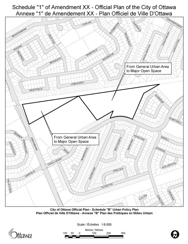
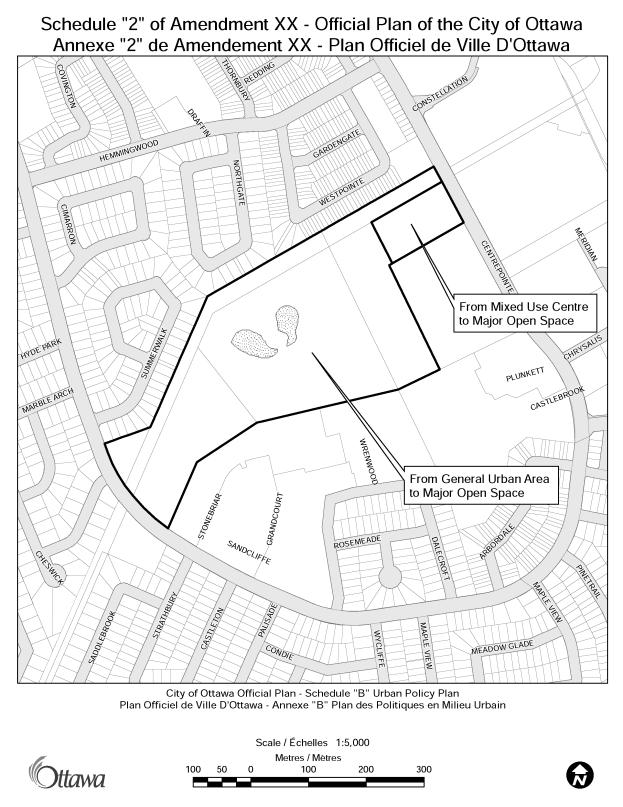
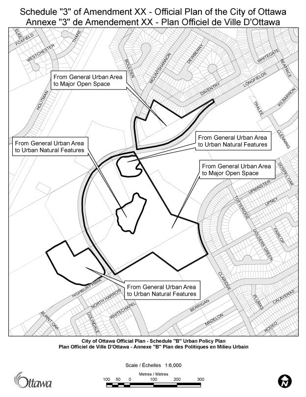
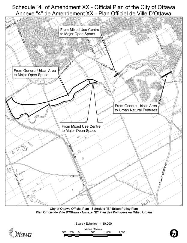
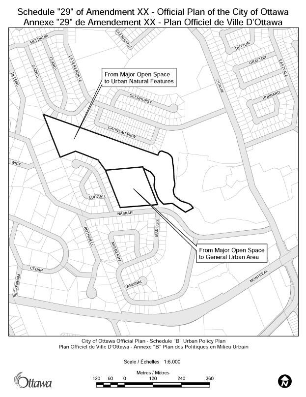
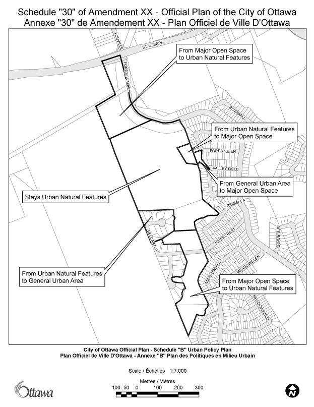
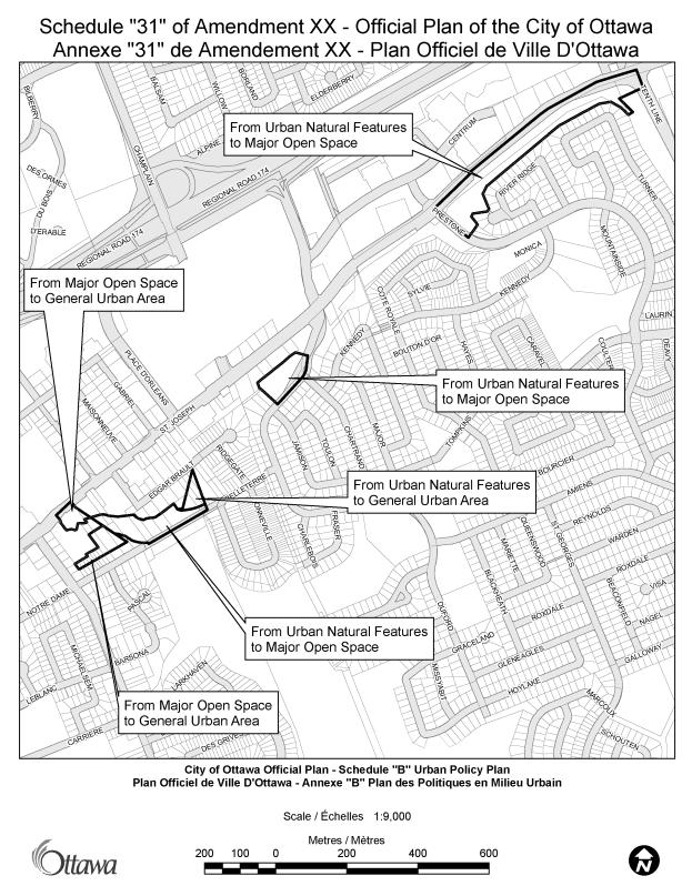
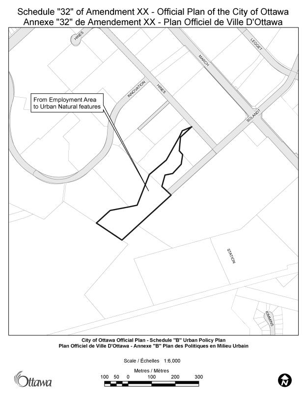
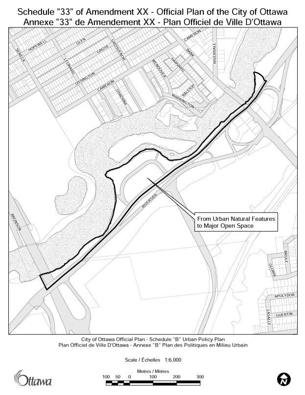
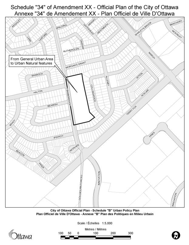
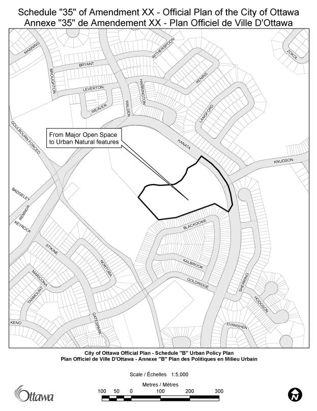
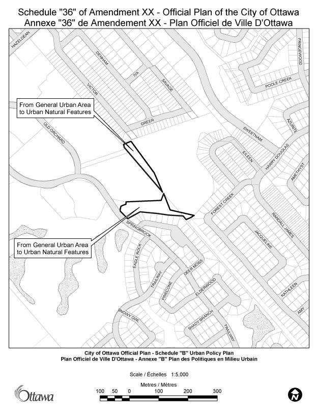
The proposed amendment implements certain recommendations of the Greenspace Master Plan (GMP) and the Urban Natural Features Strategy (UNFS). The GMP and the UNFS have identified some inadequacies in the designations on Schedule B of the Official Plan – Urban Policy Plan, which will be improved through this amendment. The amendment affects only the urban area of the City of Ottawa, and proposes additions and changes to the land use designations on Schedule B.
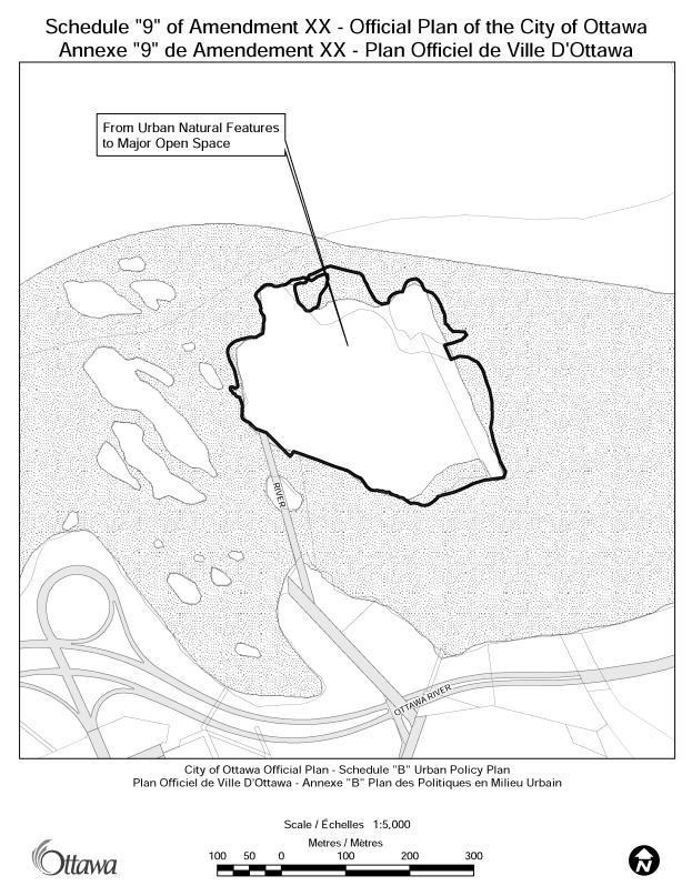
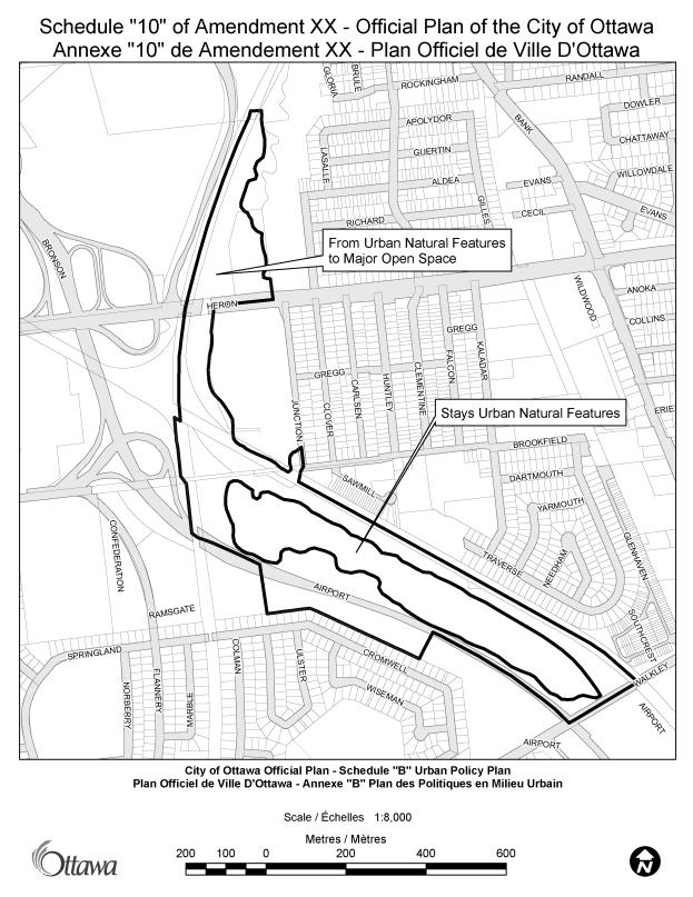
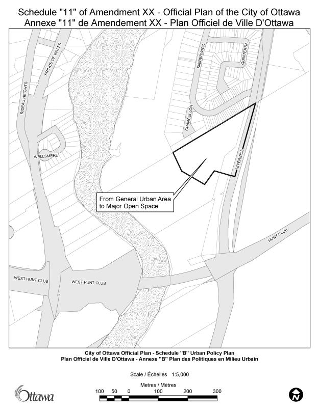
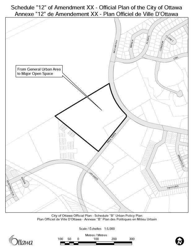
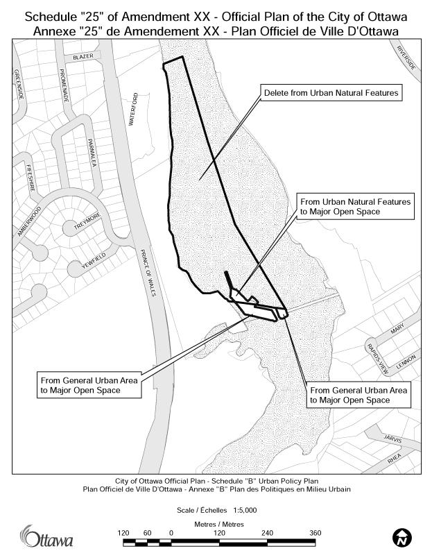
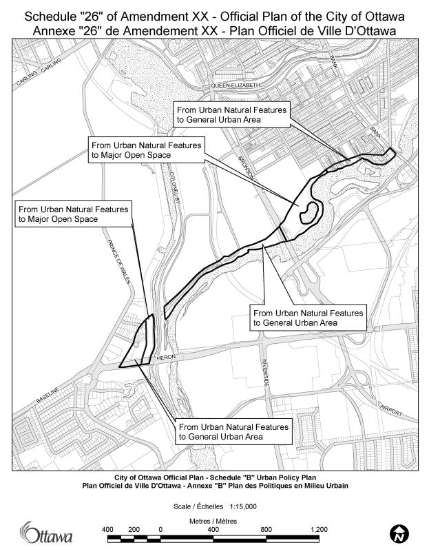
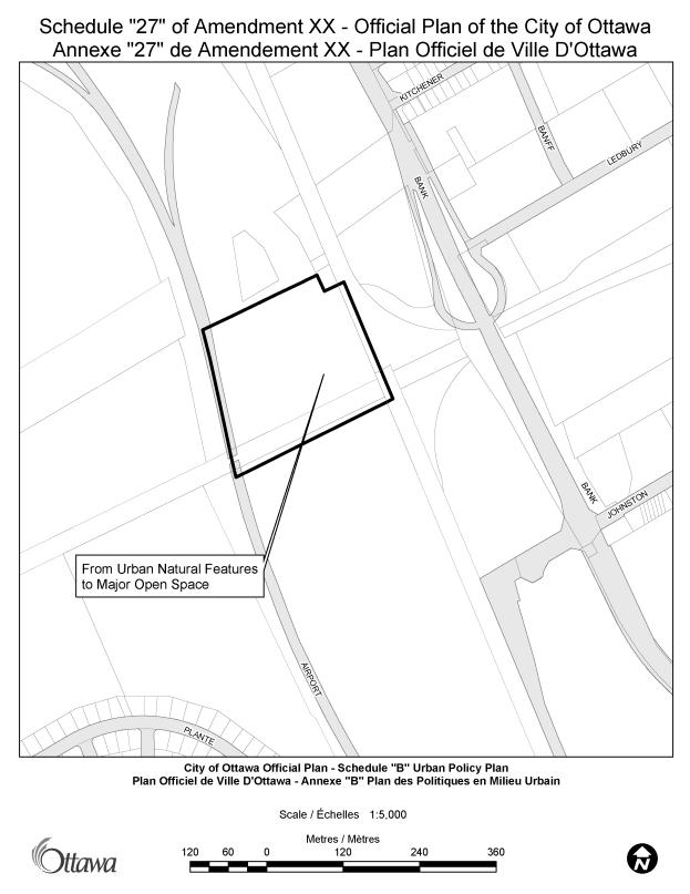
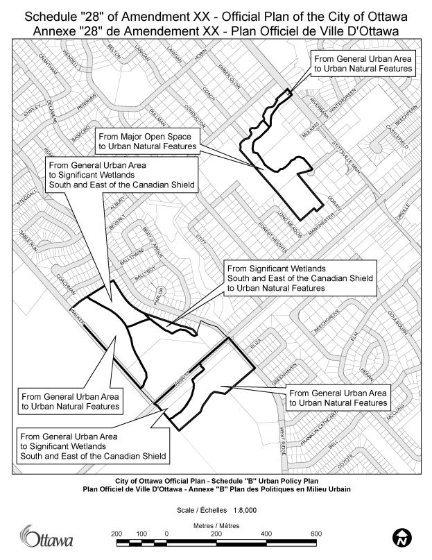
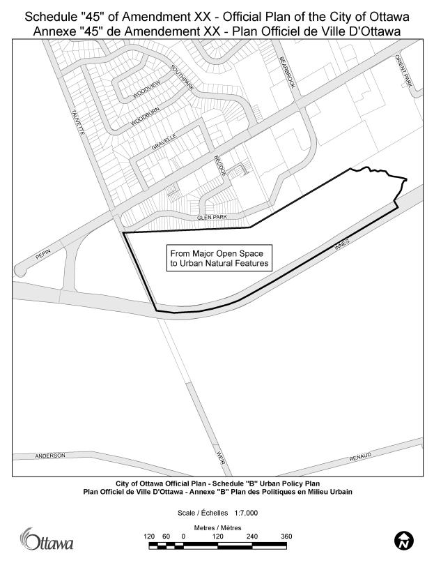
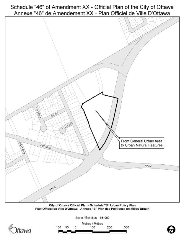
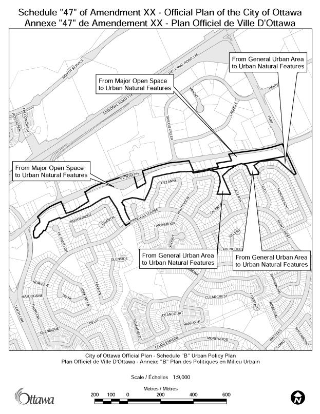
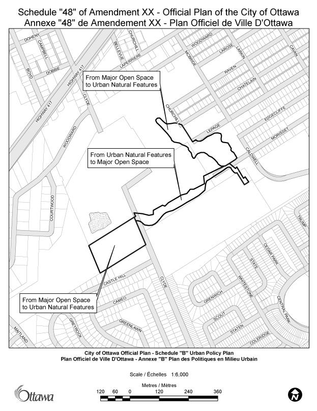
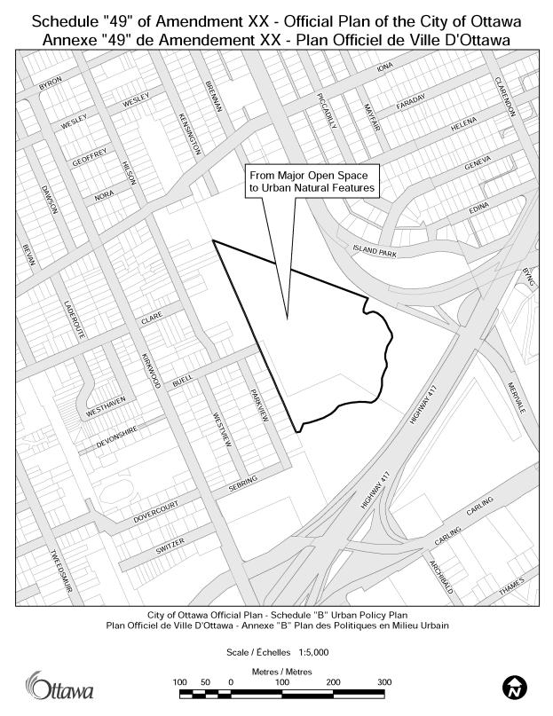
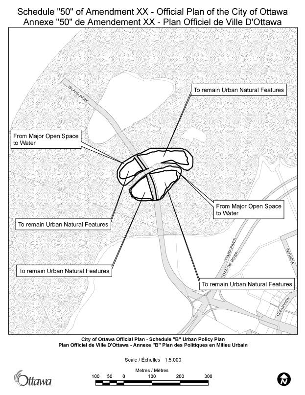
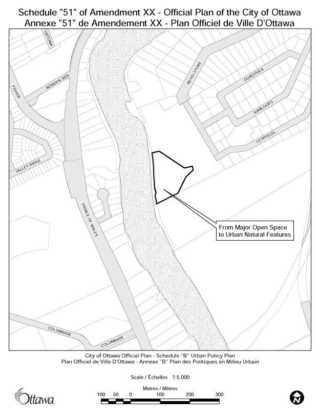
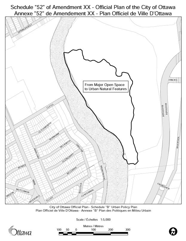
These changes are shown on the 54 Schedules that form part of the Greenspace Official Plan Amendment. No text changes to policy are proposed as part of this amendment.
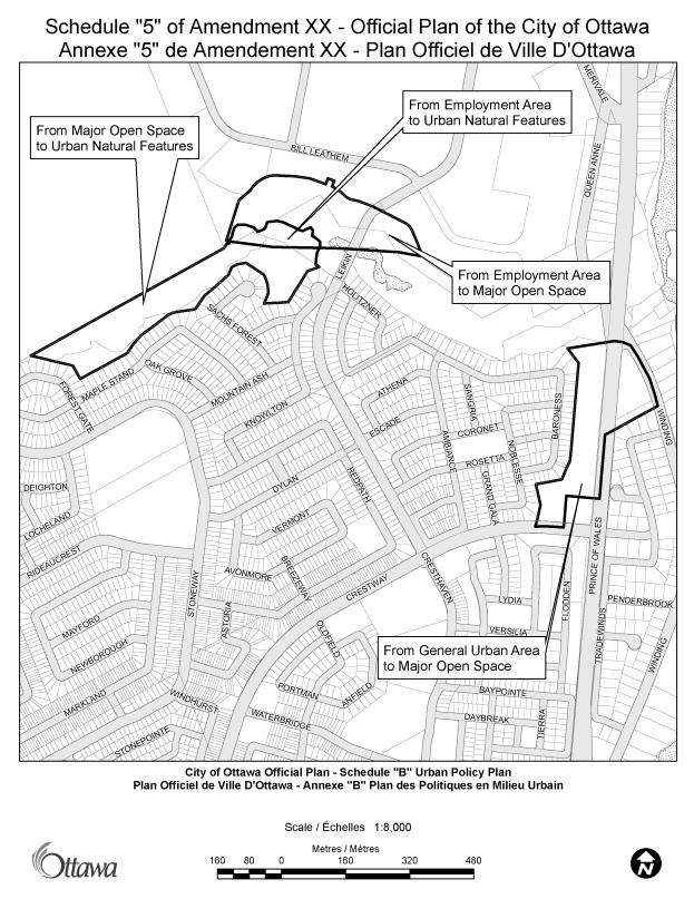
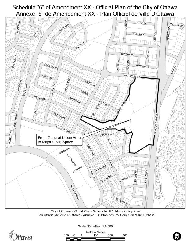
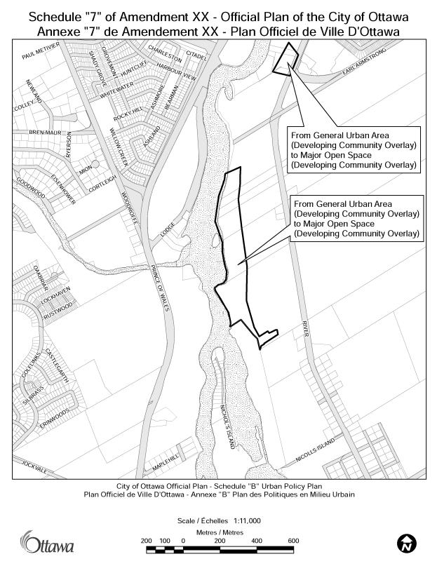
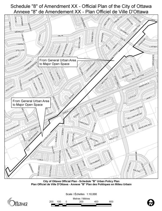
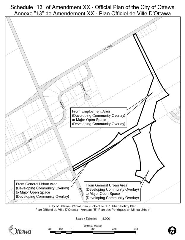
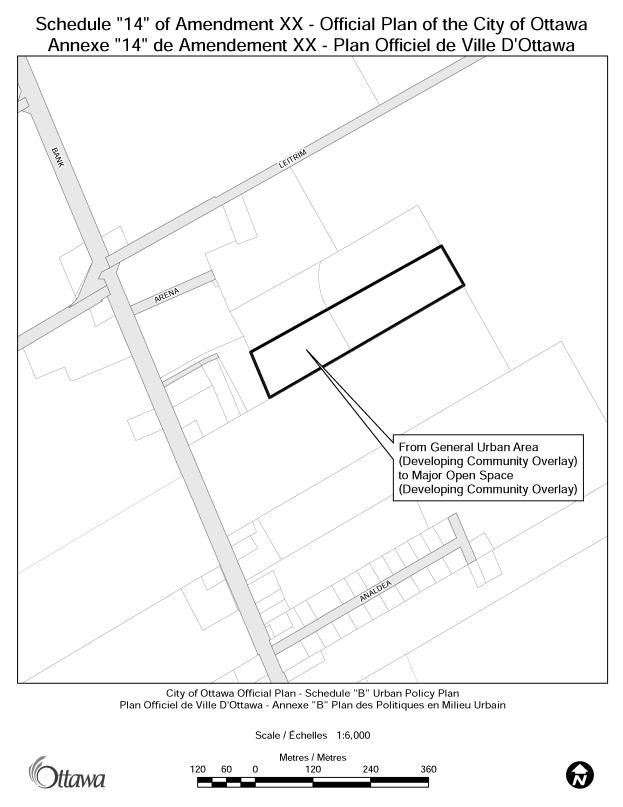
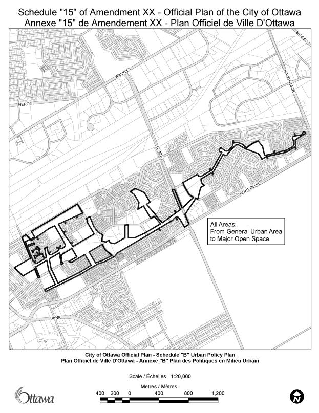
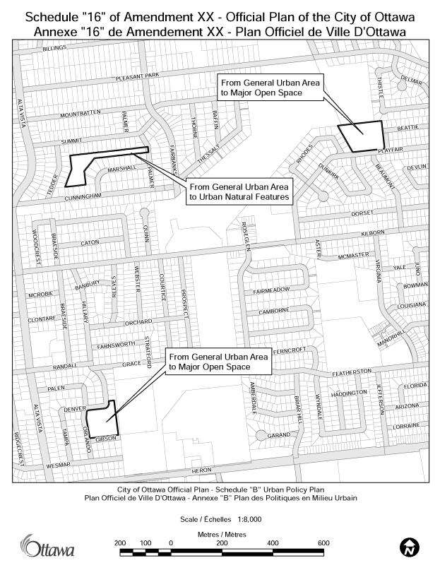
The proposed schedule changes can be classified as falling into one or more of the following categories:
(1)
adjustments to
the boundaries of existing Major Open Space, Urban Natural Features, and
Significant Wetlands designations;
(2)
designation of
a greenspace as a new Major Open Space or Urban Natural Features;
(3)
change of some
existing greenspace from Major Open Space to Urban Natural Features;
(4)
change of some
existing greenspace from Urban Natural Features to Major Open Space; and
(5)
correction of
mapping anomalies.
These re-designations primarily impact lands that are owned by the City of Ottawa or another public agency that has agreed to the proposed amendment. In cases where private property is affected, the changes are either to remove a greenspace designation that has been inappropriately placed on private lands, or to recognise greenspace within a Council approved Community Design Plan.
Corresponding revisions to the Draft Comprehensive Zoning By-law (May 2007 release) are also proposed.
CONSULTATION
Notice of this application was carried out in
accordance with the City's Public Notification and Consultation Policy. The Ward Councillors are aware of
the proposed amendment. Staff met with
NCC staff to discuss the amendment's effect on NCC owned lands. Internal meetings were also held between
Planning staff and staff of the Parks and Recreation Branch, as well as staff
of the Real Property Asset Management Branch.
Full consultation details are included in Document 2 - Consultation
Details.
FINANCIAL
IMPLICATIONS
The City’s Official Plan has land acquisition policies that apply to all privately-owned land designated Urban Natural Features and Major Open Space. This amendment applies primarily to City and other publicly-owned land where agreement from the landowners has been obtained. Where the amendment impacts privately-owned land the amendment reflects greenspaces already approved in Secondary Plans and Community Design Plans or is a correction to land already designated in the Official Plan. There are no anticipated financial implications associated with this Official Plan Amendment to Schedule B – Urban .
SUPPORTING DOCUMENTATION
Document 1 Proposed
Official Plan Amendment
Document 2 Consultation Details
Document 3 Table
of Contents
DISPOSITION
Planning, Transit and the Environment Department to prepare the by-law adopting the Official Plan Amendment, forward to Legal Services Branch, and undertake the statutory notification.
Legal Services Branch to forward the
implementing by-law to City Council
Planning, Transit and the Environment Department to update the Draft Comprehensive Zoning By-law to be consistent with this Official Plan Amendment.
PROPOSED OFFICIAL PLAN AMENDMENT Document 1
|
|

Official Plan Amendment __
Modifications du Plan directeur
To the Official Plan of the City of Ottawa
Land use
Utilisation du sol
________________________________________________________________________
INDEX
THE STATEMENT OF COMPONENTS
PART A – THE PREAMBLE
Purpose
Location
Basis
PART B – THE AMENDMENT
Introduction
Details of the Amendment
Implementation and Interpretation
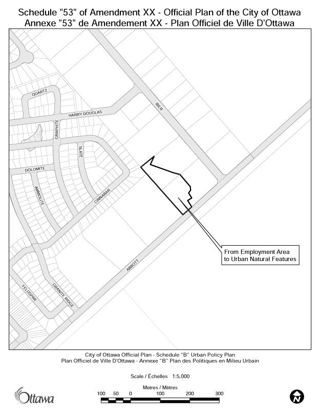
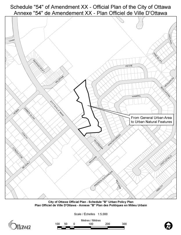
Schedules 1 to 54 of Amendment XX – Official Plan of the City of Ottawa
PART A – THE PREAMBLE
Purpose
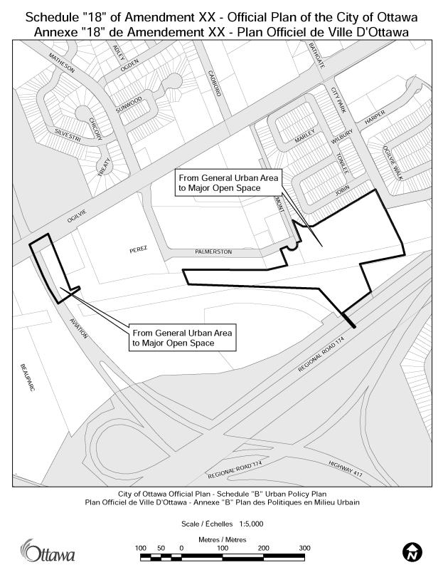
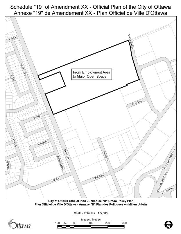
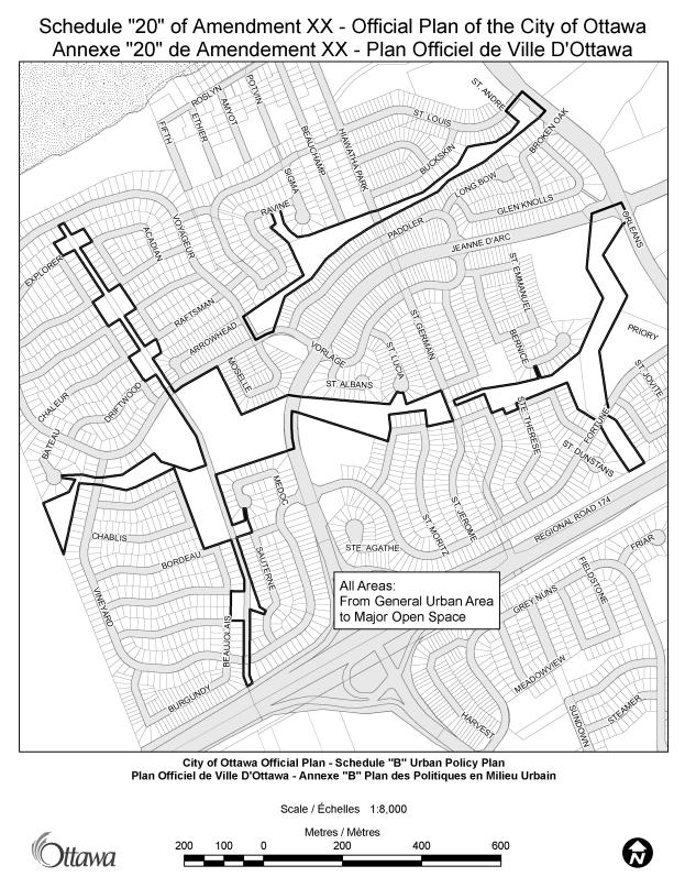
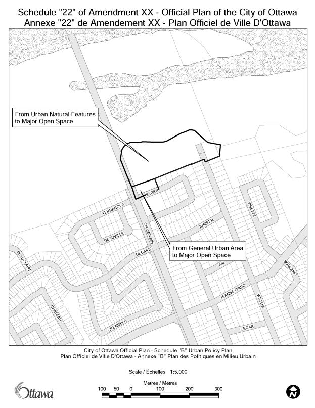
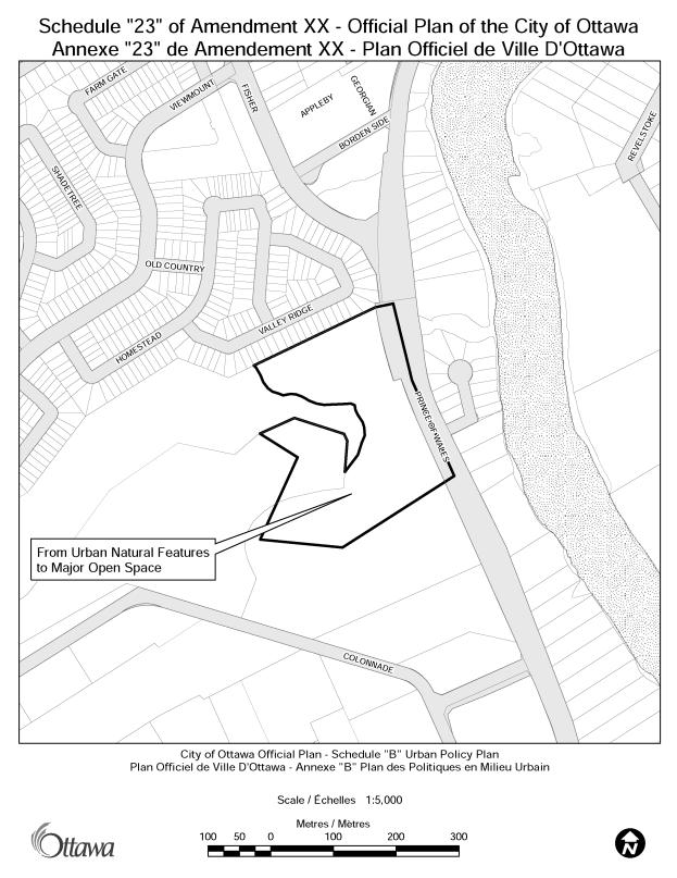
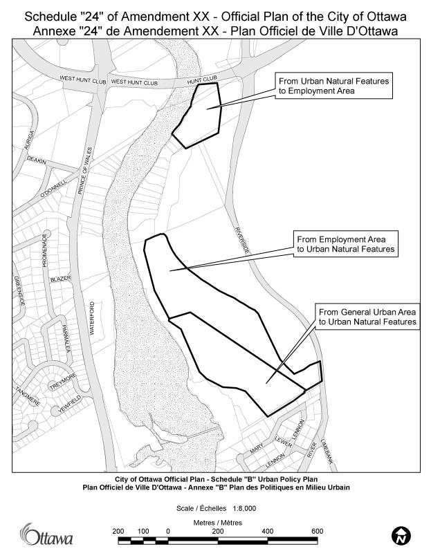
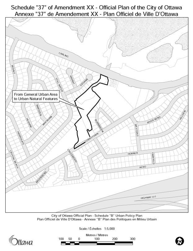
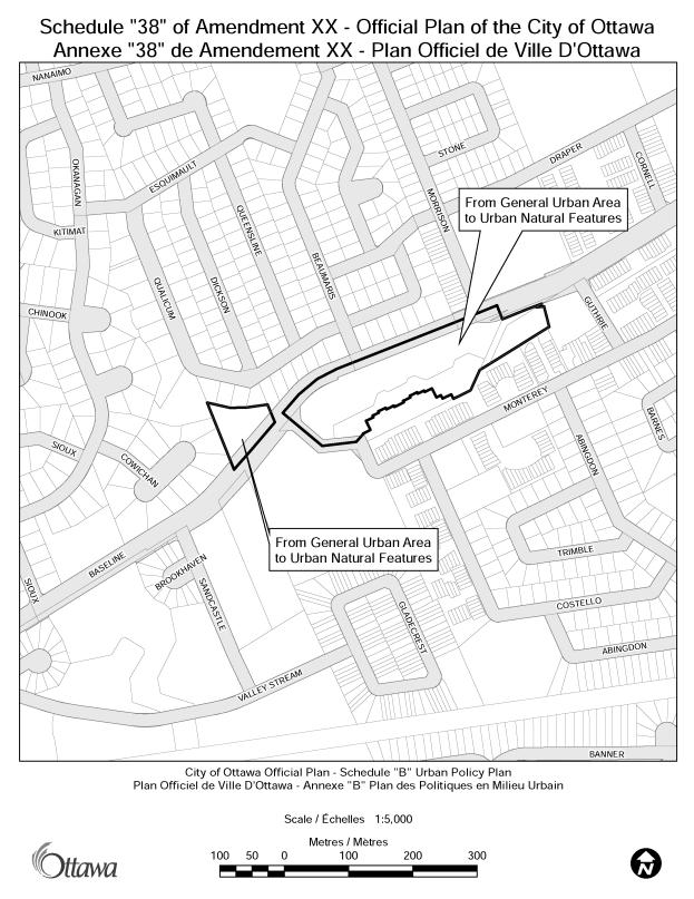
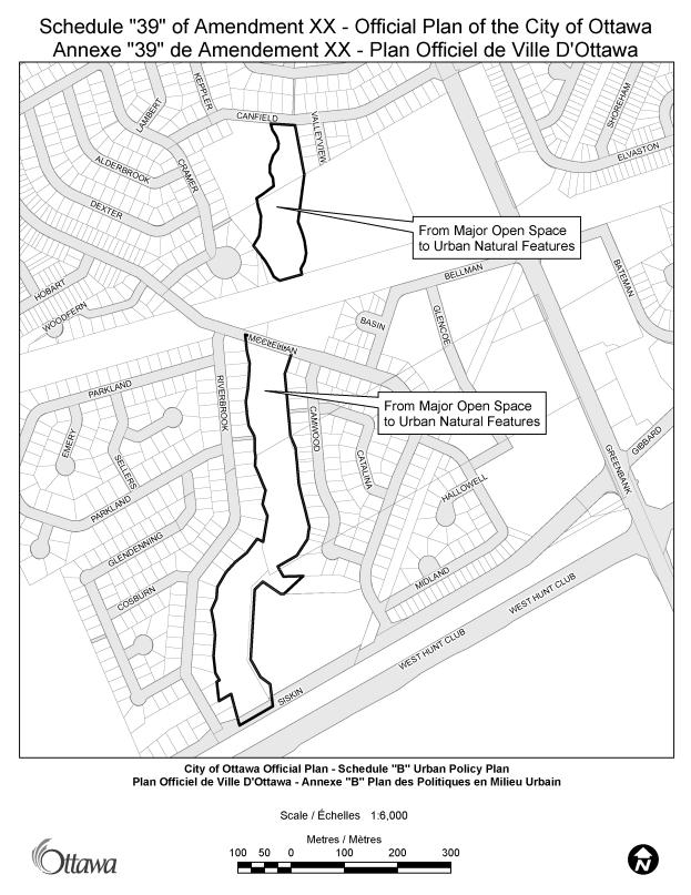
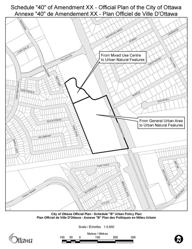
The purpose of this amendment is to make land use designation changes to Schedule B of the City of Ottawa Official Plan, as shown in Schedules 1 through 54. These changes include:
- adjustments
to the boundaries of some existing Major Open Space, Urban Natural
Features, and Significant Wetlands designations;
- the
designation of new Major Open Space and Urban Natural Features;
- changing
some existing greenspace from Major Open Space to Urban Natural Features;
- changing
some existing greenspace from Urban Natural Features to Major Open Space;
and
- the
correction of mapping anomalies that have been identified.
The amendment does not include any changes to the policies included in the text of the City of Ottawa Official Plan.
Location
This Official Plan Amendment affects the entire urban area of the City of Ottawa, as shown on Official Plan Schedule B: Urban Policy Plan.
Basis
The Greenspace Master Plan
The Greenspace Master Plan – Strategies for Ottawa’s Urban Greenspaces (GMP), a master plan that is supplemental to the Official Plan, was approved by City Council in August 2006. The purpose of the GMP is to identify and characterize all of the individual greenspaces in the city, to express City Council’s vision for greenspace in the urban area, and to set policies for how that vision can be pursued.
The GMP recommended that the City protect land that is planned and developed for conservation and recreation or for leisure purposes through the Official Plan and the Comprehensive Zoning By-law by:
- Designating all major municipal parks and Urban Natural Features consistently in the Official Plan; and
- Zoning all city-owned parks in an open space or equivalent zoning and ensure that there is public consultation where a municipal park is to be sold or changed to another use.
The Greenspace Master Plan identified the need for an amendment to the Official Plan to ensure consistent designation of greenspaces based on their function as either major open spaces or natural areas.
The GMP also identified many greenspaces that had not been identified appropriately on Schedule B. These greenspaces included previously unidentified major parks and new greenspaces that were identified through Community Design Plans.
The greenspace inventory in the Greenspace Master Plan also highlighted some areas of inaccurate greenspace identification on Schedule B that are intended to be corrected by this amendment.
The Urban Natural Features Strategy
The Urban Natural Features Strategy (UNFS) sets out the City’s intentions for protecting a priority list of natural areas in the urban area based on the Council approved Urban Natural Areas Environmental Evaluation Study (UNAEES, 2005 & 2006). The Urban Natural Features Strategy has analyzed the 192 urban natural areas in the UNAEES to determine the opportunities for and constraints to protecting the natural areas that have been identified as worthy of protection. The strategy has identified new Urban Natural Features on City and publicly owned lands that can be protected based on current or planned use of the land. In addition to the identification of new Urban Natural Features on publicly-owned lands, corrections to the boundaries of some existing Urban Natural Features on Schedule B have been identified as a result of more accurate mapping and field inspections conducted through the UNAEES.
The changes to Schedule B proposed as a result of the Urban Natural Features Strategy relate to lands owned by the City of Ottawa or other public agencies in situations where agreement to protect the natural area has been obtained. No privately owned lands identified in the Urban Natural Features Strategy as priorities for protection will be affected by the amendment.
PART B – THE AMENDMENT
1. Introduction
All of this part of this document entitled Part B – The Amendment consisting of the following text and the attached Schedules constitutes Amendment No. __ to the Official Plan of the City of Ottawa.
2. Details
The following changes are hereby made to the Official Plan of the City of Ottawa:
Schedule B: Urban Policy Plan is amended as shown on Schedules 1 through 54 of this Official Plan Amendment.
3. Implementation and Interpretation
Implementation and interpretation of this Amendment shall be in accordance with the policies of the City of Ottawa Official Plan (2003).
CONSULTATION DETAILS DOCUMENT
2
National Capital Commission
City staff met with NCC staff on February 5, 2007, to discuss the Greenspace OPA in terms of NCC owned lands that have a natural environment or major open space function. Agreement was reach on a number of NCC properties to move forward with schedule changes to better reflect the greenspace function of the lands. A total of 11 NCC properties are included in the amendment.
The NCC provided written comments concerning the 11 properties under their ownership, either supporting or providing no objection to the proposed changes. Regarding the changes proposed on Schedule 12, the City owned site at Paul Anka and McCarthy (Paul Anka Park), the NCC advised that the site should be incorporated into any future municipal planning studies for the abutting federal lands.
Hydro Ottawa
Hydro Ottawa did not object to the amendment provided that the proposed designations do not prejudice the existence of current or future Hydro Ottawa distribution assets within or near the proposed designated areas, or prejudice Hydro Ottawa’s rights to do work on these assets. These rights are recognised in the Official Plan.
Ottawa Catholic School Board
The Ottawa Catholic School Board expressed concerns regarding their
lands located adjacent to three parcels that are proposed to be amended, on
which lands shared-use facilities are located.
These three parcels, shown on Schedules 3, 15, and 43, are proposed to
be re-designated from General Urban Area to Major Open Space. This re-designation will have no impact on
the adjacent lands or the continued
operation of shared-use
facilities. The Major Open Space
designation allows sports fields and recreational park uses. The
School board has been advised of this and is satisfied that their interests are
not adversely affected.
The Ottawa Catholic School Board expressed a concern regarding the
proposed re-designation of city lands on Schedule 54 from General Urban Area to
Urban Natural Features, wondering about the effect of this re-designation on
the functioning of the adjacent school, especially with regard to the location
of portables and/or play structures. If
re-development requiring Council approval, such a site plan application, is proposed
within 30 metres of the UNF designation, an Environmental Impact Statement will
be required in accordance with Policy 5 of The UNF designation (Section
3.2.3). Section 4.7.8 - Environmental Impact Statement describes the different
types of EISs. The school lands are
adjacent to the Urban Natural Feature with a fence dividing the paved,
schoolyard from the forest area. It is
anticipated that any additional portables and/or play structures would have a
minimal impact on the adjacent natural area as the site is already paved and
development envelope defined. Any
required EIS could be scoped in nature to address any potential issues related
to any new structure or use along the edge of the feature. The School board has been advised of this
and is satisfied that their interests are not adversely affected.
The Ottawa Catholic School Board also expressed a concern regarding the
proposed re-designation of a portion of its property, shown on Schedule 3, from
General Urban Area to Urban Natural Features.
The proposed new
designation was incorrectly shown to include a portion of the school site on
the Schedule 3 that was circulated for comments. As a result of this concern,
Schedule was amended to remove the
encroachment, and the
designation of the school board property will not change. It will remain as General Urban Area. The
School Board has been advised of this change, and is satisfied that their
interests are not adversely affected.
Rideau Valley Conservation Authority
The Rideau Valley Conservation Authority expressed no objection to the
proposed Official Plan Amendment, but submitted comments to be noted for
administrative purposes regarding the proposed boundaries of the Urban Natural
Features Designations. These comments
have been received and considered.
Advisory Committees to Council
City staff attended meetings of the Environmental Advisory Committee, the Ottawa Forest and Greenspace Advisory Committee, and the Parks and Recreation Advisory Committee during the month of March 2007. At each of these meetings, staff made a presentation explaining the purpose of the amendment, and the proposed changes. Staff followed up by providing additional copies of the proposed amendment, and by providing further explanations regarding the proposed amendments. Comments from these committees have been incorporated into the amendment.
Public Consultation
A Community Heads-Up was issued, via
email, on January 15, 2007. The
Heads-Up included a brief summary of the purpose of the proposed amendment, and
was sent to all registered Community Associations within the urban area, and to
all City Councillors.
The Public and Technical Circulation
of the proposed amendment occurred between March 15 and April 10, 2007. This circulation included the draft text of
the Official Plan Amendment, including the 54 Schedules. The following comments were received as a
result of this process:
PUBLIC COMMENTS
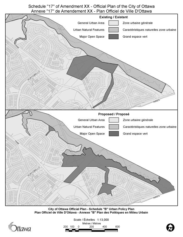
- The Cardinal
Creek Community Association expressed concerns over the changes proposed
on Schedule 17, and with the consistency of the City’s approach.
Response to Comment: As
a result of the dialogue that followed between staff and the Cardinal Creek
Community Association, changes were made to the proposed re-designations and
Schedule 17 was replaced with a new schedule detailing the current level of
greenspace and the proposed re-designations.
Explanations of the rationale for the proposed changes, as well as
confirmation of a consistent approach across the city, were also provided.
- The
Greenspace Alliance expressed a concern over the proposed changes from
Urban Natural Features to Major Open Space on specific schedules. It was
requested that these proposed changes be justified.
Response to Comment: A
meeting was held with staff on April 30, 2007.
A detailed explanation of each of the proposed changes was provided, and
the concerns of the Greenspace Alliance were alleviated. Following the meeting, changes were made to
two of the schedules to clarify the amendment.
These amended schedules for part of this report.
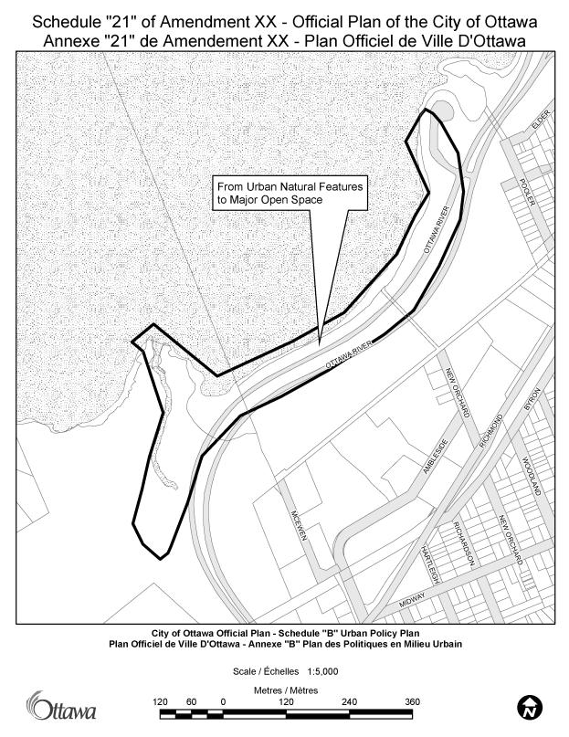
- The Woodpark
Community Association and the Woodroffe North Community Association
expressed concerns regarding the proposed re-designation shown on Schedule
No. 21 (Pinecrest Creek at Ottawa River), and requested a meeting with
staff to ensure that their concerns were understood, and to clarify the
purpose and intent of the change.
Response to Comment: A
meeting was held with staff on April 16, 2007.
The rationale for the proposed amendment was explained, and staff
undertook to provide further information regarding the proposed zoning in the
Draft Comprehensive Zoning By-law. This
information has been provided.