|
2. GOULBOURN
FORCED ROAD AND KANATA AVENUE ENVIRONMENTAL ASSESSMENTS ÉVALUATIONS ENVIRONNEMENTALES DU CHEMIN GOULBOURN FORCED
ET DE L'AVENUE KANATA
|
Committee recommendation
That Council:
1. Receive
the results of the Goulbourn Forced Road and Kanata Avenue Environmental
Assessments, as shown in Documents 2 and 6, that were developed in accordance
with the requirements of the Ontario Environmental Assessment Act and
Municipal Class Environmental Assessment.
2. Request staff prepare the Environmental
Study Report for the Goulbourn Forced Road and Kanata Avenue Environmental
Assessments for the 30-day public review, in accordance with the Ontario
Environmental Assessment Act.
Recommandation du Comité
Que le Conseil :
1. Prenne connaissance des résultats du rapport sur les évaluations environnementales du chemin Goulbourn Forced et de l’avenue Kanata, figurant aux documents 2 et 6, réalisées conformément aux exigences de la Loi sur les évaluations environnementales de l’Ontario et de l’Évaluation environnementale municipale de portée générale.
2. Demande au personnel de préparer le rapport d’évaluation environnementale du chemin Goulbourn Forced et de l’avenue Kanata pour les fins de la période d’examen public de 30 jours, conformément aux dispositions de la Loi sur les évaluations environnementales de l’Ontario.
DOCUMENTATION
1.
Deputy City Manager’s report (Public Works and Services) dated 6 June 2007 (ACS2007-PTE-APR-0137).
2.
Extract of the Draft
Minutes 9, Transportation Committee, 4 July 2007.
(To be distributed
separately prior to Council).
Report to/Rapport au :
Transportation
Committee / Comité des transports
and Council / et au Conseil
06 June 2007 / le 06 juin 2007
Submitted by/Soumis par : Nancy Schepers, Deputy City Manager/Directrice
municipale adjointe
Planning, Transit and the Environment/Urbanisme, Transport en commun et
Environnement
Contact
Person/Personne ressource : Michael Wildman, Acting Manager/Gestionnaire
intérimaire, Infrastructure Approvals/Approbation des demandes d'infrastructure
(613)
580-2424, 27811 Mike.Wildman@ottawa.ca
|
SUBJECT: |
GOULBOURN
FORCED ROAD AND KANATA AVENUE ENVIRONMENTAL ASSESSMENTS |
|
|
|
|
OBJET : |
ÉVALUATIONS
ENVIRONNEMENTALES DU CHEMIN GOULBOURN FORCED ET DE L'AVENUE KANATA |
REPORT RECOMMENDATIONS
That Transportation Committee recommend
Council:
1.
Receive the results
of the Goulbourn Forced Road and Kanata Avenue Environmental Assessments, as
shown in Documents 2 and 6, that were developed in accordance with the
requirements of the Ontario Environmental
Assessment Act and Municipal Class Environmental Assessment.
2.
Request staff
prepare the Environmental Study Report for the Goulbourn Forced Road and Kanata
Avenue Environmental Assessments for the 30-day public review, in accordance
with the Ontario Environmental Assessment
Act.
RECOMMANDATIONS DU RAPPORT
Que le Comité des transports recommande au
Conseil :
1.
De prendre acte des résultats du
rapport sur les évaluations environnementales du chemin Goulbourn Forced et de
l'avenue Kanata, figurant aux documents 2 et 6, réalisées conformément aux
exigences de la Loi sur les évaluations environnementales de l'Ontario et de
l'Évaluation environnementale municipale de portée générale.
2.
De demander au personnel de préparer
le rapport d'évaluation environnementale du chemin Goulbourn Forced et de
l'avenue Kanata pour les fins de la période d’examen public de 30 jours,
conformément aux dispositions de la Loi sur les évaluations environnementales
de l'Ontario.
EXECUTIVE
SUMMARY
Assumptions
and Analysis:
The Goulbourn Force Road is an unimproved forced road through the Marchwood/Lakeside Communities in Kanata. In the early 1980s, a Concept Plan for Marchwood/Lakeside prepared by Campeau Corporation showed a requirement for a major collector roadway in the approximate location of the current Goulbourn Forced Road, south of the Nepean-Arnprior railway. The segment north of the Nepean-Arnprior railway envisioned a realignment to the west side of the lands defined in the City’s Urban Natural Area Environmental Evaluation Study as an Urban Natural Feature (UNF), to intersect with Terry Fox Drive opposite Second Line Road. The Concept Plan alignment has been reflected in all major planning documents since the late 1980s, including the 1990 City of Kanata Official Plan (OP), the 1997 Region of Ottawa-Carleton OP and the current OP.
KNL Developments Inc. (KNL) submitted applications under the Planning Act for Draft Plan of Subdivision approval for two large subdivisions in the Marchwood/Lakeside area. The KNL application is one of many development projects anticipated in Ward 4 over the next 20 years.
A major realignment of the existing Kanata Avenue/Richardson Side Road from Goulbourn Forced Road to Terry Fox Drive was identified in the October 2000 Terry Fox Drive Environmental Study Report. Significant grades on the Carp River escarpment necessitated a new alignment for the east leg of Kanata Avenue at its intersection with Terry Fox Drive. Portions of the new alignment for Kanata Avenue were constructed as part of the extension project of Terry Fox Drive north of Campeau Drive in 2003; however, the Terry Fox Drive Environmental Study Report did not address the functional design requirements or Environmental Assessment (EA) approval requirements for the realignment and reconstruction of Kanata Avenue east of Terry Fox Drive.
Financial
Implications:
- The total estimate construction cost of the Goulbourn Forced Road is $15.2 M for approximately 2.2 km of road, including noise impact mitigation, future rail grade‑separation, and all required works.
- The total estimated construction cost of Kanata Avenue is $3.0 M for approximately 750 m of road.
- The current phase 1 portions of the project are Goulbourn Force Road from Kanata Avenue to Keyrock Drive and Kanata Avenue from Goulbourn Force Road to Stikine Road, and funding of $4.459 M is approved in the Capital Budget for this phase.
Public Consultation/Input
The EA studies were undertaken as Class EAs for Municipal Road Projects under a Schedule C project. The public consultation events for both projects were held simultaneously and the details are listed below:
- “Notice of Project Commencement” advertised in local newspapers;
- Public Open House #1 – March 2, 2006;
- Public Consultation Group (PCG)/Stakeholder Meeting – June 21, 2006;
- Public Open House #2 – June 29, 2006;
- Public Open House #3 – December 12, 2006;
- One-on-one meetings with the Ottawa-Carleton Catholic School Board (OCCSB), All Saints High School Parent Council, Community Association Executive Committees, private landowners, area developers, etc;
- Agency Consultation Group (ACG) meetings – throughout the course of the study;
- Various inquiry contacts; and
- Transportation Committee – June 20, 2007.
RÉSUMÉ
Hypothèses et analyse :
Le chemin
Goulbourn Forced est un chemin rudimentaire aménagé dans les collectivités de
Marchwood/Lakeside, à Kanata. Au début des années 80, le plan conceptuel de
Marchwood/Lakeside préparé par la Corporation Campeau prévoyait la construction
d’une grande route collectrice à peu près au même endroit que le chemin
Goulbourn Forced actuel, au sud de la ligne de chemin de fer Nepean‑Arnprior.
On envisageait pour la partie nord de la ligne de chemin de fer Nepean‑Arnprior
un réalignement du côté ouest des terrains définis dans l’Étude
d’évaluation environnementale des espaces naturels urbains comme étant une caractéristique naturelle urbaine (CNU), qui permettrait de croiser la
promenade Terry Fox en face du chemin Second Line. L’alignement proposé dans le
plan conceptuel se retrouve dans tous les grands documents de planification
depuis la fin des années 80, y compris le Plan officiel (PO) de la Ville de
Kanata de 1990, celui de 1997 de la région d’Ottawa‑Carleton et le Plan
officiel actuel.
KNL Developments Inc. (KNL) a présenté, en vertu de la Loi sur
l’aménagement du territoire, des demandes
d’approbation des projets d’aménagement de deux grands lotissements dans le
secteur
Marchwood/Lakeside. La demande de KNL n’est que l’une des nombreuses demandes
pour des projets prévus dans le quartier 4 au cours des vingt prochaines
années.
Le rapport sur l’évaluation environnementale de
la promenade Terry Fox d’octobre 2000 faisait état de la nécessité de procéder
à un réalignement majeur de l’avenue Kanata et du chemin de traverse Richardson
entre le chemin Goulbourn Forced et la promenade Terry Fox Drive. Les pentes
importantes de l’escarpement de la rivière Carp imposaient un nouvel alignement
du tronçon est de l’avenue Kanata à son intersection avec la promenade Terry
Fox. Certaines portions du nouvel alignement de l’avenue Kanata ont été
construites dans le cadre du projet de prolongement de la promenade Terry Fox
au nord de la promenade Campeau en 2003. Cependant, l’Étude d’impact de la promenade Terry Fox sur l’environnement ne s’est
pas penchée sur les exigences conceptuelles fonctionnelles ou les exigences
d’approbation de l’évaluation environnementale (ÉE) du réalignement et de la reconstruction
de l’avenue Kanata à l’est de la promenade Terry Fox.
Répercussions financières :
- Le
coût total estimé des travaux de construction du chemin Goulbourn Forced
est d’environ 15,2 millions de dollars, pour environ 2,2 km de route. Ce
chiffre comprend le coût des mesures d’atténuation du bruit, de tout futur
saut de mouton et de l’ensemble des travaux nécessaires.
- Le
coût total estimé des travaux de construction de l’avenue Kanata est
d’environ 3 millions de dollars, pour environ 750 mètres de route.
- Les
tronçons mis en chantier lors de la phase 1 du projet visent le chemin
Goulbourn Force, de l’avenue Kanata à la promenade Keyrock, et l’avenue
Kanata, du chemin Goulbourn Force au chemin Stikine, avec un financement
de 4,459 millions de dollars approuvé dans le budget d’immobilisations.
Consultation publique/Commentaires :
Les ÉE ont été réalisées dans le cadre des évaluations
environnementales de portée générale des projets municipaux de construction de routes de l’annexe C. On a
organisé pour les deux projets des réunions de consultation simultanées dont
voici le détail.
- Publication
d’un « avis de lancement de projet » dans les journaux locaux.
- Réunion
publique no 1 – 2 mars 2006.
- Réunion
du groupe de consultation publique (GCP) et des intervenants – 21 juin 2006.
- Réunion
publique no 2 – 29 juin 2006.
- Réunion
publique no 3 – 12 décembre2006.
- Réunions
personnalisées avec l’Ottawa-Carleton Catholic School Board (OCCSB), le
Conseil des parents d’élèves de l’école secondaire All Saints, les comités
exécutifs des associations communautaires, des propriétaires fonciers
privés, des promoteurs, etc.
- Réunions
du groupe de consultation des organismes (GCO) tout au long de l’étude.
- Divers
contacts pour obtenir des renseignements.
- Comité
des transports – 20 juin 2007.
BACKGROUND
Description of Projects
The City has completed a Class EA Study for the reconstruction and realignment of Goulbourn Forced Road from Kanata Avenue to Terry Fox Drive and Kanata Avenue from Richardson Side Road to Goulbourn Forced Road. The study was undertaken to determine the alignment, profile and cross-section for both Goulbourn Forced Road and Kanata Avenue and establish the seek Environment Assessment Act approvals for the projects.
Report Organization
This staff report presents the results of two different EA studies, for both Goulbourn Forced Road and Kanata Avenue. While they are distinct projects, they are being presented together in this report as they are both located in the same vicinity in the west end of the city, they include overlapping sections (i.e. the intersection of Goulbourn Forced Road/Kanata Avenue) and have similar need requirements. As well, presenting them together allows any member of the public to address Transportation Committee about both projects at the same time.
This staff report is organized in the following manner:
- Section A – Goulbourn Forced Road; and
- Section
B – Kanata Avenue.
Documents 1 to 7 identify the study area graphics, illustrations of the Recommended Plan, detailed summaries of the public consultation events and evaluation process for each study.
Planning Context for Both Studies
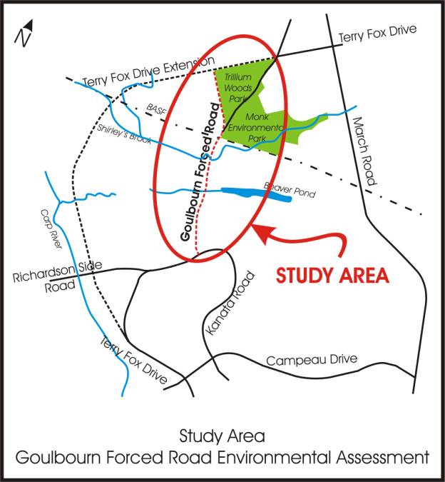
Goulbourn Forced Road, as it exists today is a forced road from Kanata Avenue to Terry Fox Drive and currently has a substandard road cross section for a collector road. In the late 1970s, Goulbourn Forced Road was identified as the possible key north-south transportation spine for the Marchwood/Lakeside communities of Kanata. In the early 1980s, a Concept Plan for Marchwood/Lakeside prepared by Campeau Corporation showed a requirement for a major collector roadway in the approximate location of the current Goulbourn Forced Road south of the Nepean-Arnprior railway. The segment north of the Nepean-Arnprior railway envisioned a realignment of the major collector to the west side of the UNF as described in the City’s Urban Natural Area Environmental Evaluation Study, to intersect with Terry Fox Drive opposite Second Line Road. The UNF lands are commonly referred to as the Trillium Woods and the Monk Environmental Park. The Concept Plan alignment has been reflected in all major planning documents since the late 1980s, including the 1990 City of Kanata OP, the 1997 Region of Ottawa-Carleton OP, and the current 2003 City of Ottawa OP.
Development has occurred on the east side of
the segment of Goulbourn Forced Road from Kanata Avenue to the Kizell and
Beaver Pond. Plans of Subdivision and a Plan of Condominium have been
developed. When approving these developments, the plans took into consideration
the future continued development within the Marchwood/Lakeside community and
accounted for a future alignment of the Goulbourn Forced Road. The Plan of
Condominium development has access directly onto the original forced road and
will ultimately have access to the realigned Goulbourn Forced Road. Blocks
within some of the plans have been created which will later be made into
building lots once the final alignment of this southerly segment has been
approved.
KNL and Richcraft Homes have submitted applications under the Planning Act for Draft Plan of Subdivision approval for three large subdivisions in the Marchwood-Lakeside area. The these subdivisions are many of the development projects anticipated in Ward 4 over the next 20 years, which could ultimately generate more than 7000 residential units and 278 700 square metres of business park development. The KNL Draft Plan of Subdivision showed an assumed alignment for Goulbourn Forced Road that was consistent with previous alignments.
A major realignment of the existing Kanata Avenue/Richardson Side Road from Goulbourn Forced Road to Terry Fox Drive was identified in the October 2000 Terry Fox Drive Environmental Study Report. Significant grades on the Carp River escarpment necessitated a new alignment for the east leg of Kanata Avenue at its intersection with Terry Fox Drive. Portions of the new alignment for Kanata Avenue were constructed as part of the extension project of Terry Fox Drive north of Campeau Drive in 2003; however, the Terry Fox Drive Environmental Study Report did not address the functional design requirements or EA requirements for the realignment and reconstruction of Kanata Avenue east of Terry Fox Drive. Given the potential for modification to the alignment, location and/or of the Kanata Avenue/Goulbourn Forced Road intersection as part of the Goulbourn Forced Road EA, it was determined that it would be appropriate for these two projects to proceed through the planning process together.
Official Plan Conformity
The OP supports development of lands adjacent to Goulbourn Forced Road and Kanata Avenue, which will drive the need to upgrade both roads to urban standards. Both roads are in the OP and designated as Major Collector roads. Both roads have been part of the planned Marchwood/Lakeside Community road network for more than 30 years.
Purpose of the Undertaking
The purpose of the undertaking is to respond to growth pressures by providing adequate transportation capacity in the study area. In addition, to support the growth within Ottawa as a liveable and economically viable city by planning infrastructure and services that are required to encourage sustainable land use practices, support desired modal shifts, prevent congestion and delay, and minimize air pollution.
SECTION A – GOULBOURN FORCED ROAD ENVIRONMENTAL ASSESSMENT
DISCUSSION
Goulbourn Forced Road is currently a rural collector roadway with horizontal and vertical design parameters (minimum curve radii, maximum gradient) below current design guidelines and has a cross-section that is narrow and without other features, such as shoulders and pedestrian facilities. Currently Goulbourn Forced Road has very limited development adjacent to its corridor; therefore, intersections and driveways are minimal in number. The assumed speed limit on Goulbourn Forced Road is 50 km/hr., as there is no posted speed limit.
There are a number of development applications for lands adjacent to the existing Goulbourn Forced Road between Kanata Avenue and Terry Fox Drive that will drive a significant change in the character of Goulbourn Forced Road. All of the lands between Kanata Avenue and the Kizell Pond and Beaver Pond on both sides of Goulbourn Forced Road are slated for development in that the OP designation is General Urban. Most of this land is subject to current development applications. Development will continue north of the Kizell Pond and Beaver Pond on both sides of Goulbourn Forced Road up to the Nepean-Arnprior Railway.
North of the railway the adjacent land use will depend on the alignment chosen for Goulbourn Forced Road. The existing forced road alignment splits the Trillium Woods/Monk Environmental Park UNF. The originally planned realignment of Goulbourn Forced Road to the west side of the Trillium Woods would have land use on the west side of Goulbourn Forced Road being a mix of commercial, residential, and institutional uses.
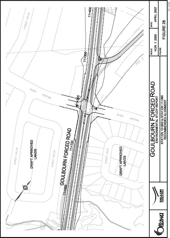
Several intersections are proposed with the new Goulbourn Forced Road including (from south to north):
- Kanata Avenue (Major Collector road);
- Badgeley Drive (Collector road);
- Keyrock Drive (Collector road);
- Access to the Kanata Rockeries Condominiums (existing private road);
- Walden Drive (Collector road);
- Street No. 1 from the KNL Draft Plan of Subdivision (Collector road); and
- Terry Fox Drive (Arterial road).
Document 1 illustrates the Goulbourn Forced Road Study Area.
Problem/Opportunity Statement
The roadway structure of Goulbourn Forced Road needs to be improved to carry the volume of traffic forecasted for the post-development scenario in Ward 4 and to provide an adequate road base for a typical Major Collector road cross-section.
The horizontal and vertical geometry of Goulbourn Forced Road needs to be modified to meet current City of Ottawa road design guidelines for Major Collector roads. The KNL Draft Plan of Subdivision also provides the opportunity to realign the northern segment of Goulbourn Forced Road to the west edge of the UNF as has long been intended, to reduce the impacts of the road on the important natural feature.
The projected traffic volumes for the future traffic on Goulbourn Forced Road indicate that once Goulbourn Forced Road is reconstructed to typical municipal standards for a two lane Major Collector road, there will be no additional road capacity requirements. Reconstruction of Goulbourn Forced Road to typical Major Collector road design parameters will provide sidewalks and bicycle lanes on both sides of the road between Kanata Avenue and Terry Fox Drive.
Alternative Planning Solutions
The Class EA for Municipal Roadways requires that alternative solutions be identified for the problem/opportunity. For roadway capacity deficiencies, the Class EA suggests that the following alternatives be investigated:
- Do Nothing;
- Transportation System Management/Transportation Demand Management (TSM/TDM) measures;
- Alternative transportation modes;
- Traffic diversion to other roadways/correct deficiency elsewhere in the network;
- Widening of other roadways; and
- Reconstruction/widening of Goulbourn Forced Road.
Drawing on the policies and recommendations of
numerous supporting documents such as the OP and Transportation Master Plan
(TMP), the Terry Fox Drive Environmental Study Report and the Kanata North
Neighbourhood Transportation Study, the following addresses the extent to which
each of these alternatives could solve the problem taking into account their
potential environmental impacts and costs.
- Do Nothing - The Do Nothing alternative does not include any new significant improvements. Although the costs and environmental impacts of the Do Nothing alternative are low, this alternative does not solve the Goulbourn Forced Road structural or capacity deficiencies. The Do Nothing option is not capable of meeting the problem/opportunity statement.
- Transportation Systems Management (TSM) and Transportation Demand Management (TDM) - TSM measures include various methods of maximizing the use of the existing roads (e.g., traffic control devices, signage, turning lanes). TDM measures reduce the demand for private automobile use (e.g., ridesharing, carpooling, telecommuting, etc.). TSM and TDM measures were assumed in forecasting future roadway capacity needs for the TMP and the Kanata North Neighbourhood Transportation Study. Roadway capacity deficiencies were still identified assuming a significant level of TDM/TSM, and these measures do not address the structural deficiencies on Goulbourn Forced Road.
- Alternative Transportation Modes - Significant increases in pedestrian, cycling and transit modal shares were assumed in the forecasting of road demands. Road capacity deficiencies were still identified, and the structural deficiencies on Goulbourn Forced Road remain. Thus, this alternative alone cannot solve the identified problem/opportunity.
- Traffic Diversion to Other Roadways/Correct Deficiency Elsewhere - Widening March Road, the Terry Fox Drive extension and the Solandt Road extension are alternatives to which traffic could be diverted to address capacity deficiencies. These alternatives were fully considered within the Kanata North Neighbourhood Transportation Study. Traffic diversion to these roadways will not, however, address local roadway access needs for the planned developments, and diversions do not address the structural deficiencies on Goulbourn Forced Road. This alternative was, therefore, not considered to be capable of solving the problem/opportunity and was not considered further.
- Road Widenings - The widening of existing roads was considered to address the projected deficiency of north-south roadway capacity. With the exception of the Terry Fox Drive extension, the City’s OP and TMP do not identify capacity improvements, which would add roadway capacity to Kanata North prior to 2020. In addition, widening other roadways does not address local roadway access needs for the planned developments. The option of widening other roadways was not considered further.
- Reconstruct Goulbourn Forced Road - Reconstruction of Goulbourn Forced Road as a two-lane road using typical Major Collector road design parameters will provide enough structural capacity on Goulbourn Forced Road, will provide adequate carrying capacity, and will provide bicycle and pedestrian facilities within the corridor. This alternative will significantly contribute to solving the problem/opportunity.
Preferred Solutions
The preferred alternative solution, as originally identified in the TMP and the Kanata North Neighbourhood Transportation Study, includes a combination of: TDM/TSM measures; alternative transportation modes (i.e. increased walking, cycling and transit); and reconstruction of Goulbourn Forced Road.
Analysis and Evaluation Process
It was possible to divide Goulbourn Forced Road into two distinct segments based on the range of logical alternatives to be considered:
· Section 1 - Kanata Avenue to Walden Drive, where there were no centreline options, and alternatives focused on different methods for crossing the Kizell and Beaver Ponds; and
· Section 2 - Walden Drive to Terry Fox Drive, where there were a number of centreline options.
The centreline profiles associated with the
range of design alternatives were reviewed and it was determined that the
profiles for all options could easily be made to match at the boundary between
the segments (i.e., Walden Drive); therefore it was concluded that design
options within each segment could be generated and evaluated independently,
without the decisions in one segment prejudicing the decisions in the other.
Document 3 contains a detailed description of the analysis and evaluation process, including illustrations of the various alternatives considered.
Section 1 - Kanata Avenue to
Walden Drive
The Richcraft and KNL Draft Plans of Subdivision suggested a centreline alignment for Goulbourn Forced Road between Kanata Avenue and Walden Drive that rationalized the property impacts between Richcraft, Urbandale, and KNL and provided acceptable horizontal curve radii for this segment of Goulbourn Forced Road. No other centreline options were considered for this segment.
It was suggested by some stakeholders that an alignment be considered for Goulbourn Forced Road that would create an aligned four-leg intersection with either, the most westerly driveway to All Saints High School or the middle driveway to All Saints High School. An alignment that accommodated either of these accesses would have significant property impacts on either the Richcraft subdivision (the westerly access) or the existing Urbandale commercial property in the northeast quadrant of the Goulbourn Forced Road/Kanata Avenue intersection. The impetus for either of these suggested options was to allow full access to the school through both driveways and maintain acceptable traffic operations in the vicinity of the Goulbourn Forced Road/Kanata Avenue intersection. There are a number of existing on-site access and circulation issues that should be resolved with All Saints High School, which will likely lead to changes in the access and circulation pattern. The construction of these collector roads will not resolve the internal concerns. Given this, and the impacts that would result from realigning Goulbourn Forced Road to match the location of the school driveways, these options were dropped without detailed evaluation.
Design Options for Crossing the Kizell Pond
and Beaver Pond
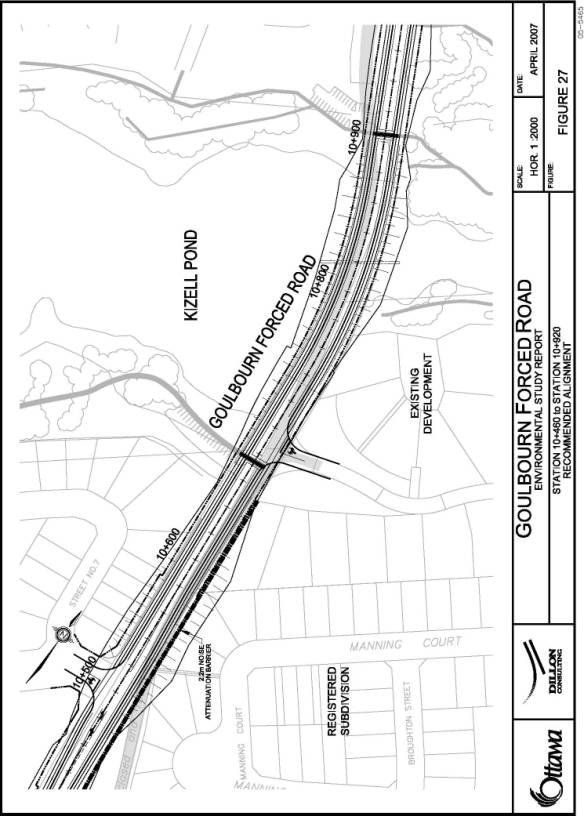
Goulbourn Forced Road currently crosses the Kizell Pond and Beaver Pond via a causeway with a culvert to accommodate flow between the Ponds. Two design options were developed for the future Goulbourn Forced Road crossing of the Ponds:
1. Construct a bridge over the “valley” that would provide superior access and safety for pedestrians walking on the recreational pathways adjacent to the Ponds; and
2. Replace the existing causeway/culvert with a new causeway/culvert.
No differences were identified between the options with respect to the Natural Environment and Transportation Environment. The advantages and disadvantages of the two crossing options, including analysis and evaluation details, are discussed in Document 3.
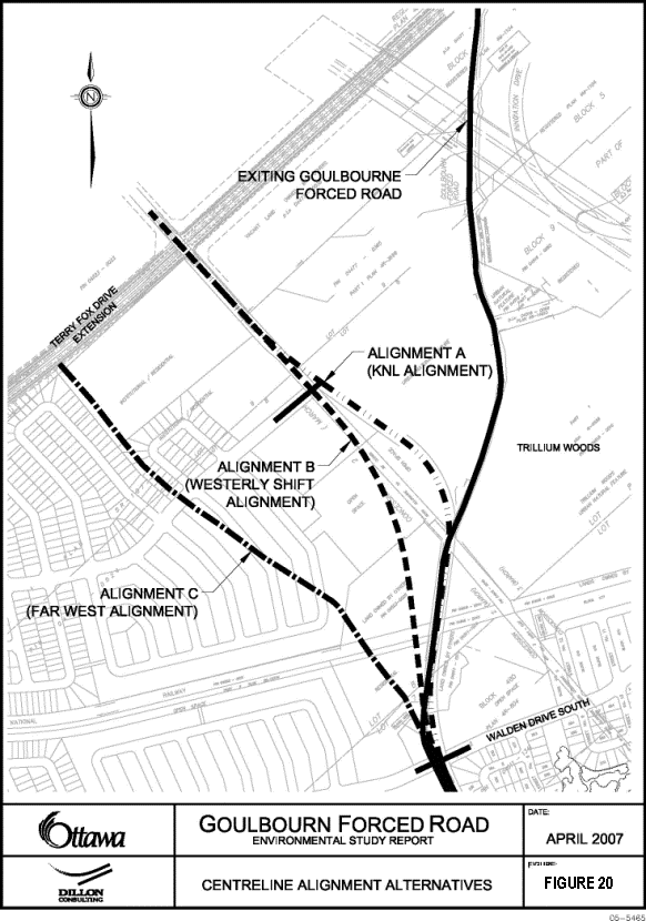
Section 2 - Walden Drive to Terry
Fox Drive
Four
centreline options were identified for Goulbourn Forced Road, between Walden
Drive and the future Terry Fox Drive extension. They are described as follows:
The Existing Goulbourn Forced
Road Alignment
This option follows the existing Goulbourn Forced Road alignment from Kanata Avenue to Terry Fox Drive. While this option attempts to follow the existing alignment as closely as possible, current geometric standards result in the new roadway diverting from the existing alignment in several locations.
The existing Goulbourn Forced Road Alignment alternative was dismissed from consideration without detailed evaluation as a potential alignment option for the following reasons:
· Reconstruction of Goulbourn Forced Road on its existing alignment would increase the already significant impact of Goulbourn Forced Road on Trillium Woods/Monk Environmental Park;
· The existing alignment is inconsistent with long range planning documents and current developments adjacent to the Goulbourn Forced Road corridor. These future developments would still require the construction of north-south collector road west of Trillium Woods;
· The alignment does not provide a suitable intersection location at the northern terminus of Goulbourn Forced Road (i.e. at the Terry Fox Drive/Flamborough Drive/Innovation Way intersection); and
· The alignment provides no clear net advantages.
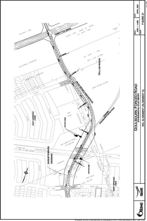
The KNL Alignment
This alignment option would see the northern segment of Goulbourn Forced Road realigned to the west side of Trillium Woods to intersect the Terry Fox Drive extension at the future Second Line Road allowance. This alignment alternative was established through long-range planning exercises such as the former City of Kanata OP, the current Ottawa Official and Transportation Master Plans. The rationale for the realignment of the northern segment is to reduce the impacts of this road on Trillium Woods/Monk Environmental Park. This alignment is consistent with KNL’s proposed development concepts along Goulbourn Forced Road.
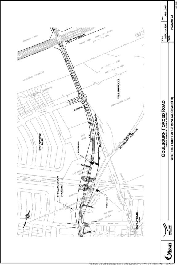
The Westerly Shift Alignment
Following the same rationale as the KNL Alignment, this option would also see the northern segment of Goulbourn Forced Road realigned to the west side of Trillium Woods and intersecting the Terry Fox Drive extension at the future Second Line Road allowance. The major difference between the two options is that the realignment of the northern segment in the Westerly Shift Alignment is more severe than the realignment in the KNL Alignment (i.e., Goulbourn Forced Road is pushed further to the west). The rationale for doing so is to avoid all possible impacts on Trillium Woods/Monk Environmental Park. While this alignment option is consistent with long-range planning documents, it deviates from proposed development concepts along Goulbourn Forced Road.
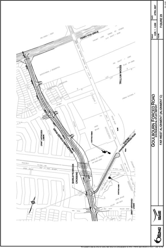
The Far West Alignment
This alignment option would see the northern segment of Goulbourn Forced Road realigned west of Trillium Woods and intersect the Terry Fox Drive extension approximately 300 metres west of the future Second Line Road allowance. When compared to the location of the other alignment alternatives, the Far West Alignment is located significantly west of the other options as the location of the KNL Alignment and the Westerly Shift Alignment are only subtly different when compared to the Far West Alignment.
The Far West Alignment alternative was established to minimize the impact on both private property owners and on Trillium Woods/Monk Environmental Park. This alignment deviates from proposed development concepts along Goulbourn Forced Road.
The advantages and disadvantages of the various alignment alternatives, including analysis and evaluation details, are discussed in Document 3.
Recommended Plan
Goulbourn Forced Road will be divided into four phases. Phase 1 includes the section of Goulbourn Forced Road from Kanata Avenue to Keyrock Drive (just north of Keyrock Drive). Phase 1 will be constructed in conjunction with Phase 1 of Kanata Avenue, in the fall of 2007. Phase 2 includes the section of Goulbourn Forced Road from Keyrock Drive (just north of Keyrock Drive) to Kanata Rockeries driveway. Phase 2 may be constructed in conjunction with Phase 1, subject to availability of existing capital authority. Phase 3 includes the section of Goulbourn Forced Road from the Kanata Rockeries driveway to Walden Drive South. Phase 3, is currently expected to be constructed in 2011 subject to Council advancement of budgetary funding. Phase 4 includes the section of Goulbourn Forced Road from Walden Drive South to Future Terry Fox Drive extension 300 meters west of Second Line Road allowance. Phase 4 is currently expected to be constructed post 2016 subject to availability of funds and will be coordinated with the construction with the future Terry Fox Drive extension.
Section 1 - the Causeway/Culvert Option was selected as the technically preferred design treatment for the Goulbourn Forced Road crossing of the Kizell Pond and Beaver Pond due to a significantly lower capital cost.
Section 2 – the Far West Alignment was selected as the preferred design for Section 2 because it does not impact the Terrestrial Habitat of Trillium Woods and because it has the least impact to existing residences.
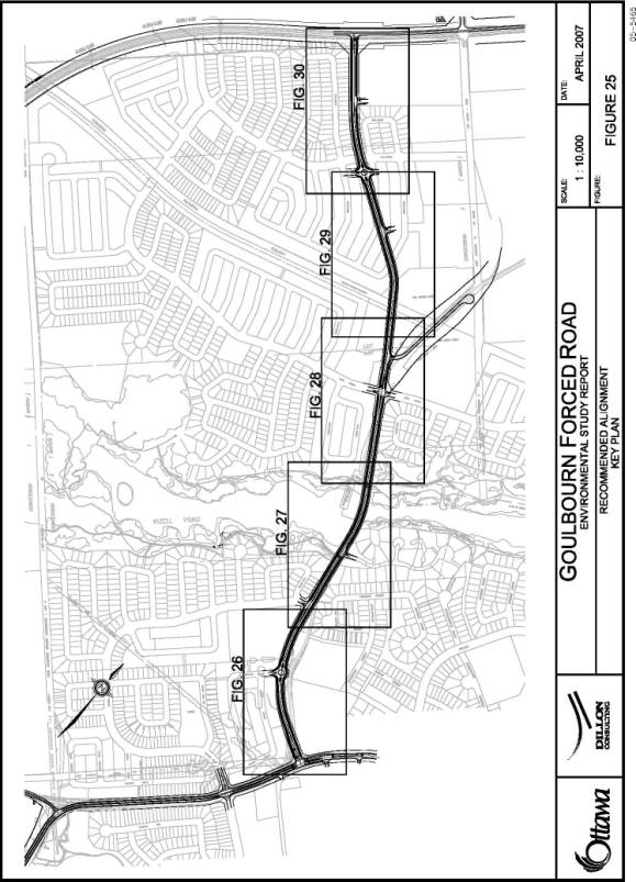
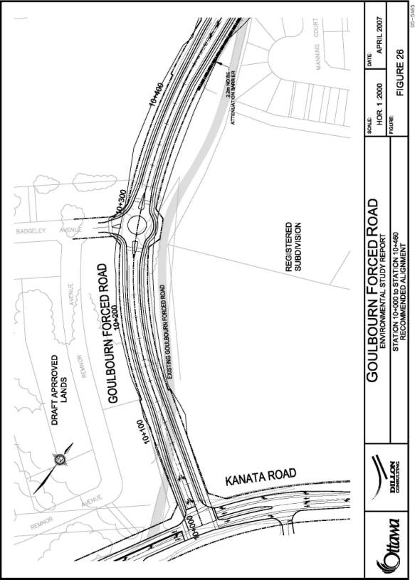
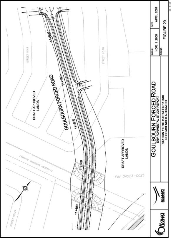
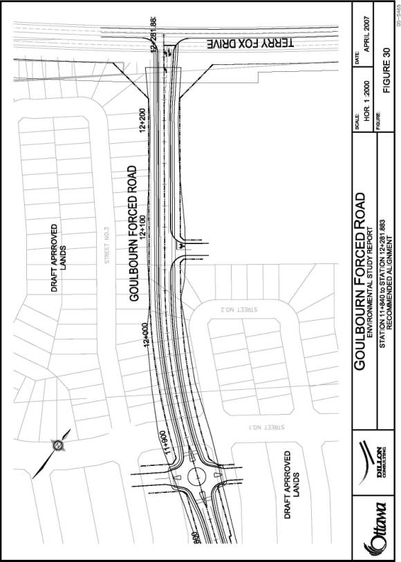
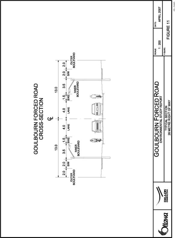
The Recommended Plan and cross-section are illustrated in Document 2.
Document 5 summarizes property impacts and mitigation measures.
CONSULTATION
The Goulbourn Forced Road EA was carried out in accordance with the Municipal Engineer’s Association Class EA Process for Municipal Road Projects (2000) as a Schedule C project. During the course of the study, regular update meetings were held with the ACG and PCG to seek input, direction and concurrence on the study findings and recommendations.
The following is a
list of public consultation activities for this study:
· “Notice of Project Commencement” advertised in local newspapers;
· Public Open House #1 – March 2, 2006;
· PCG/Stakeholder Meeting – June 21, 2006
· Public Open House #2 – June 29, 2006;
· Public Open House #3 – December 12, 2006;
· One-on-one meetings with the OCCSB, All Saints High School Parent Council, Community Association Executive Committees, private landowners, area developers, etc;
· ACG Meetings – throughout the course of the study;
· Various inquiry contacts; and
· Transportation Committee – June 20, 2007.
The public consultation efforts for this study were successful. The various committees, public associations and public groups/individuals were kept informed of the ongoing activities of this study as well as the outcome through the events listed above. At the conclusion of the study, the majority of comments received from members of the public were of a positive nature.
Consensus was reached on almost all issues, with the exception of:
- Treatment of pond crossing; and
- Assumed
treatment of future rail grade-separation.
The concerns that were raised are:
Pond Crossing:
Goulbourn Forced Road currently crosses the
Pond complex (i.e., Beaver Pond/Kizell Pond) via a causeway with a culvert to
accommodate flow between the Ponds. Two design options were developed for the
future Goulbourn Forced Road crossing of the Pond complex:
1. Construct a bridge over the “valley” that would provide superior access and convenience for pedestrians walking on the recreational pathways adjacent to the Ponds; and
2. Replace the existing causeway/culvert with a new causeway/culvert.
The primary opposition identified by members of the public to the preferred Causeway/Culvert Option is focussed around their opinion that this option does not provide for convenient recreational access to the ponds. While it is acknowledged that the bridge option would provide a superior recreational crossing, the options have been rated on a number of criteria. They indicated that it was their impression that the Bridge Option would be more environmental friendly for any opportunity for wildlife to travel from one pond area to another. No differences were identified between the options with respect to the Natural Environment and Transportation Environment criteria groups.
The advantages and disadvantages of the two crossing options are as follows:
· The Bridge Option ranked highest under the Existing Recreational Features criterion in that it provides an unconstrained crossing of the pond complex. While the Culvert Option maintains the existing crossing condition, which is an at-grade crossing with adequate user safety, no option provides the same level of convenience to recreational users as the Bridge Option; and
· Due a significantly lower overall estimated capital cost, the Causeway/Culvert Option ranked highest (i.e. $100,000 for the culvert/causeway structure versus $1,600,000 for the bridge structure).
As a result of the above, the Causeway/Culvert
Option is selected as the preferred design treatment for the Goulbourn Forced
Road crossing of the Pond Complex.
Nepean-Arnprior Railway Crossing
Stakeholder consultation identified a desire to
consider designing the grade-separated crossing of the Nepean-Arnprior Railway
utilizing reinforced earth walls in place of berms on the bridge approaches to
minimize property impacts/requirements. The concern expressed related to the
potential loss of development land should an earth embankment design be
utilized. Under a reinforced earth wall design treatment the required ROW for
the overpass would remain at, or close to, 26 metres. The current design
treatment utilizes earth embankments, which require in excess of an 80 metre
ROW at certain locations.
The preferred design treatment for the crossing
was determined by comparing trade-offs between the capital costs of the
reinforced earth walls and the total cost of berm construction (including
capital costs and value of the property consumed by the earth embankment
treatment). The cost to construct the structure assuming reinforced earth wall
is significant higher ($7.5 million) than the earth embankment treatment ($2.2
million). As such, the earth embankment treatment was selected as the preferred
design for the grade-separated crossing of the Nepean-Arnprior Railway.
Based on the analysis completed through the
evaluation process, it is felt that the preferred alternatives satisfy the
roadway design requirements in a satisfactory manner and meets or exceeds a
majority of issues raised through the public process. Document 4 provides
additional detail with respect to consultation activities held over the course
of the study.
SECTION B – KANATA
AVENUE ENVIRONMENTAL ASSESSMENT
DISCUSSION
Kanata Avenue between Richardson Side Road and Goulbourn Forced Road is currently a rural collector roadway with a cross-section that is without a number of desirable features, such as bicycle lanes and pedestrian facilities. This section of what is now called Kanata Avenue is the original Richardson Side Road that has a rural collector status in the OP. When the road was originally built it was not placed within the legal road right-of-way due the presence of a large rock outcrop. With the development of lands south of the existing road, the southerly edge of the future road allowance was established. The current road corridor has well established back‑lotted development on the south side. Through the Draft Plan Approval for lands north of the current road, the City will acquire the full road right-of-way and Kanata Avenue will have development backing onto both sides of the right-of-way. Currently, intersections and driveways are minimal in number. The assumed speed limit on this portion of Kanata Avenue is 50 km/hr, as there is no posted speed limit. East of the study area Kanata Avenue is posted at 40 km/hr; west of the study area Kanata Avenue has a posted speed limit of 70 km/hr.
The Draft Plan of Subdivision for the Richcraft lands on the north side of Kanata Avenue, west of Goulbourn Forced Road will generate a fourth leg to the existing Kanata Avenue/Stikine Drive intersection. The Richcraft subdivision will occupy all of the land between Goulbourn Forced Road and Richardson Side Road. The design concept is for back-lotted residential dwellings; therefore there will be no direct driveways to Kanata Avenue.
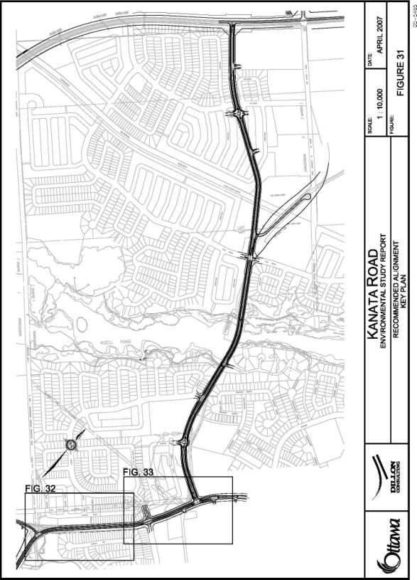
Document 6 illustrates the Kanata
Avenue Study Area.
Problem/Opportunity Statement
The construction of the planned Richcraft subdivision on the northwest corner of the intersection of Goulbourn Forced Road/Kanata Avenue will eliminate the unopened road allowance for Kanata Avenue. A new road allowance/ROW is required for Kanata Avenue between Richardson Side Road and Goulbourn Forced Road.
Projected traffic volumes suggest that no additional road capacity is required on Kanata Avenue beyond that which can be expected from the reconstruction of Kanata Avenue to typical municipal standards for a two lane Major Collector road.
Reconstruction of Kanata Avenue to typical Major Collector road design parameters will provide sidewalks and bicycle lanes on both sides of the road between Richardson Side Road and Goulbourn Forced Road.
Alternative Planning Solutions
The Class EA for Municipal Roadways requires that alternative solutions be identified for the problem/opportunity. For roadway capacity deficiencies, the Class EA suggests that the following alternatives be investigated:
- Do Nothing;
- TSM/TDM measures;
- Alternative transportation modes;
- Traffic diversion to other roadways/correct deficiency elsewhere in the network;
- Widening of other roadways; and
- Reconstruction/widening of Kanata Avenue.
Drawing on the policies and recommendations of numerous supporting documents such as the OP and TMP, the Terry Fox Drive ESR and the Kanata North Neighbourhood Transportation Study, the following addresses the extent to which each of these alternatives could solve the problem taking into account their potential environmental impacts and costs.
- Do Nothing - The Do Nothing option is not capable of meeting the problem/opportunity statement.
- Transportation Systems Management (TSM) and Transportation Demand Management (TDM) - TSM measures include various methods of maximizing the use of the existing roads (e.g., traffic control devices, signage, turning lanes). TDM measures reduce the demand for private auto use (e.g., ridesharing, carpooling, telecommuting, etc.). TSM and TDM measures were assumed in forecasting future roadway capacity needs for the TMP and the Kanata North Neighbourhood Transportation Study. TDM and TSM measures alone will not address the need to establish a legal right-of-way for Kanata Avenue.
- Alternative Transportation Modes - Significant increases in pedestrian, cycling and transit modal shares were assumed in the forecasting of road demands. This alternative alone, however, cannot solve the identified problem/opportunity.
- Traffic Diversion to Other Roadways/Correct Deficiency Elsewhere - Traffic diversion to other roadways will not address local roadway access needs for the planned developments, and diversions do nothing to establish a legal right-of-way for Kanata Avenue. This alternative was, therefore, not considered to be capable of solving the problem/opportunity and was not considered further.
- Road Widenings - widening other roadways does not address local roadway access needs for the planned developments nor does it establish a legal right-of-way for Kanata Avenue. The option of widening other roadways was not considered further.
- Reconstruct Kanata Avenue- Reconstruction of Kanata Avenue as a two-lane road in a legally accepted right-of-way using typical Major Collector road design parameters will provide adequate carrying capacity, and will provide bicycle and pedestrian facilities within the corridor. This alternative will significantly contribute to solving the problem/opportunity.
Preferred Solutions
The preferred solution includes a combination of: TDM/TSM measures; alternative transportation modes (i.e. increased walking, cycling and transit); and reconstruction.
Analysis and Evaluation Process
Given that the purpose of the Kanata Avenue EA is to establish a legally acceptable right-of-way for an urban Major Collector road, no other alterative solutions are capable of solving the problem/opportunity.
No centreline options were considered for
Kanata Avenue within the study area. Development approvals for the adjacent
lands have, over time, established a 34 metre wide corridor for Kanata Avenue
centered on the existing centreline. There was no compelling rationale for
considering alternative centrelines, as any other option would have increased
potential traffic-related noise impacts on the existing residents, and there
were no problems with the existing centreline that needed to be resolved.
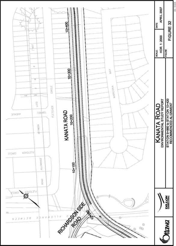
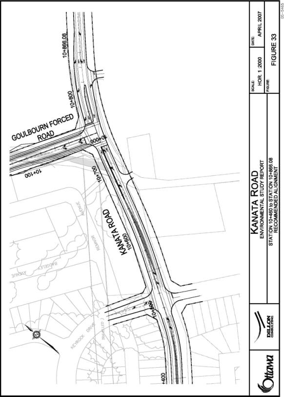
Recommended Plan
Kanata Avenue is split into two phases. Phase 1 consist of the intersection modifications at Kanata Avenue and Goulbourn Forced Road (includes section of Kanata Avenue from Stikine Road to east of Goulbourn Forced Road). Phase 1 is expected to be constructed in the fall of 2007. Phase 2 consists of the section of Kanata Avenue from Stikine Road to Richardson Side Road. Phase 2 is currently expected to be constructed in 2010 as build out occurs, subject to Council advancement of budgetary funding.
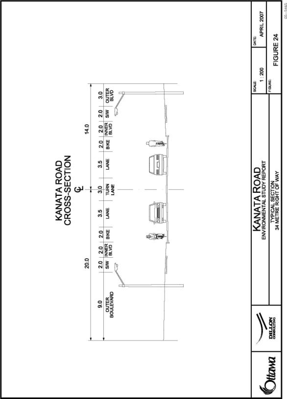
Reconstruct/realign the section of Kanata Avenue, from Richardson Side Road to Goulbourn Forced Road, as a Major Collector road with a 34 metre right-of-way (existing sections of Kanata Avenue within and outside of the study area include a 34 metre right-of-way).
The Recommended Plan and Cross Section are illustrated in Document 7.
Document 5 summarizes property impacts and mitigation measures.
CONSULTATION
The Kanata Avenue EA was carried out in accordance with the Municipal Engineer’s Association Class EA Process for Municipal Road Projects (2000) as a Schedule C project. During the course of the study, regular update meetings were held with the ACG and PCG to seek input, direction and concurrence on the study findings and recommendations.
The following is a list of public consultation activities for this study:
- “Notice of Project Commencement” advertised in local newspapers;
- Public Open House #1 – March 2, 2006;
- PCG/Stakeholder Meeting – June 21, 2006
- Public Open House #2 – June 29, 2006;
- Public Open House #3 – December 12, 2006;
- One-on-one meetings with the OCCSB, All Saints High School Parent Council, Community Association Executive Committees, private landowners, area developers, etc;
- ACG Meetings – throughout the course of the study;
- Various inquiry contacts; and
- Transportation Committee – June 20, 2007.
The public consultation efforts for this study were successful. The various committees, public associations and public groups/individuals were kept informed of the ongoing activities of this study as well as the outcome through the events listed above. At the conclusion of the study, the majority of comments received from members of the public were of a positive nature.
Consensus was reached on almost all issues, with the exception of potential impacts to circulation and access patterns at All Saints High School. The City has committed to working with OCCSB to resolve circulation and access patterns; however, potential solutions are beyond the scope of the EA study.
Document 4 provides additional detail with respect to consultation activities held over the course of the study.
FINANCIAL IMPLICATIONS
The total estimated cost for the construction of Kanata Avenue and Goulbourn Forced Road and total estimated operational impact to the City is summarized in the following tables.
Project Cost
|
Total Estimated Cost Based on EA |
|
|
Goulbourn Forced Road- Kanata Avenue to Terry Fox Drive |
$ 15,200,000 |
|
Kanata Avenue- Richardson Side Road to Goulbourn Forced Road (approximately 750m) |
$ 3,000,000 |
|
Total |
$ 18,200,000 |
Account Number Summary For Phase
1 Construction
|
Account Number |
Existing Capital Authority |
Amount (90% DC Funded, 10% City Funded) |
|
903891, Kanata Ave/Goulbourn Road |
2006 |
$ 740,000 |
|
|
2007 |
$ 3,544,000 |
|
903253, Traffic Signals and Intersection Improvements Program |
2007 |
$ 175,000 |
|
|
$ 4,459,000 |
The City’s Long Range Financial Plan and Development Charge By-law will be updated to reflect the Capital Funding in excess of the current funding approval.
SUPPORTING DOCUMENTATION
Document 1 Goulbourn Forced Road EA Study Area
Document 2 Recommended Plan and Cross-Section for Goulbourn Forced Road
Document 3 Goulbourn Forced Road EA Analysis and Evaluation Details
Document 4 Goulbourn Forced Road EA and Kanata Avenue EA Public Consultation Details
Document 5 Property Impacts and Mitigation
Document 6 Kanata Avenue EA Study Area
Document 7 Recommended Plan and Cross-Section for Kanata Avenue
DISPOSITION
DISPOSITION – FOR SECTIONS A AND B
Planning, Transit and the Environment Department to prepare the Environmental Study Report for Goulbourn Forced Road and initiate the 30-day public review period.
Planning, Transit and the Environment Department to prepare the Environmental Study Report for Kanata Avenue and initiate the 30-day public review period.
GOULBOURN FORCED
ROAD EA STUDY AREA DOCUMENT
1
RECOMENDED PLAN AND CROSS SECTION DOCUMENT
2
FOR GOULBOURN FORCED ROAD
GOULBOURN FORCED ROAD EA ANALYSIS AND DOCUMENT
3
EVALUATION DETAILS
Impact Assessment and Comparative Evaluation of Pond Crossing
Alternatives
Table 1 provides a summary of the comparative evaluation for the two crossing alternatives of the Beaver Pond and Kizell Pond.
As can be
seen from Table 1, no differences
were identified between the options with respect to the Natural Environment and
Transportation Environment criteria groups. The advantages and disadvantages of
the two crossing options are as follows:
· The Bridge Option was preferred under the Existing Recreational Features criterion (Social Environment Criteria Group) in that it provides a more convenient, unconstrained crossing of the pond complex. It is important to note that this criterion does not represent pedestrian safety, which was determined to be equal between the options. It should also be noted that an at-grade pedestrian crossing of Goulbourn Forced Road would also need to be maintained with the Bridge option, due to potential personal security concerns by some user groups with pedestrian underpass treatments.
· The Causeway/Culvert Option was preferred under the Capital and Operating Cost criterion (Engineering Environment Criteria Group) as the costs for this option were significantly less than those for the Bridge option (i.e. $100,000 for the culvert/causeway structure versus $1,600,000 for the bridge structure).
Based on these results, the Causeway/culvert option was selected as preferred.
|
Table 1 Summary of Comparative Evaluation Beaver Pond/Kizell Pond Crossing Alternatives |
|||
|
Criteria Group |
Criteria |
Bridge
Structure |
Causeway/Culvert |
|
Natural Environment |
All criteria |
Rank: Equal The Bridge Option will
remove 0.6 ha of Terrestrial Habitat and 1.0 ha of Wetlands within UNF lands.
The areas of loss are considered to be equivalent. |
Rank: Equal The Culvert Option will
remove 0.5 ha of Terrestrial Habitat and 0.7 ha of Wetlands within
UNF lands. The areas of loss are considered to be equivalent. |
|
Social Environment |
Impact
on Existing Residences and/or Registered Plans of Subdivision |
Rank: Equal The Bridge Option removes
approximately 400 square metres of registered lands from 2 registered lots
within the Kanata Rockeries Condominium Development. It will also increase
the profile of Goulbourn Forced Road through the Kanata Rockeries access by
approximately 2 metres. The Bridge Option would impact the internal lot
fabric, the internal street system and subdivision grading and drainage. All
impacts can be mitigated. |
Rank: Equal The Culvert Option removes
approximately 485 square metres of registered lands from 2 registered lots
within the Kanata Rockeries Condominium Development. The Culvert Option will
not increase the profile of Goulbourn Forced Road through the existing Kanata
Rockeries access. All impacts can be mitigated. |
|
Existing Recreational
Features |
Rank: First The Bridge Option provides
an unconstrained crossing of Goulbourn Forced Road. The Bridge Option
improves the existing condition. |
Rank: Second The Culvert Option would at
least maintain the existing crossing condition. With the Culvert Option,
opportunities exist to enhance the existing crossing condition (i.e.
pedestrian crossing signals); however, no option would provide the same level
of safety as the Bridge Option. |
|
|
Trans-portation Environment |
All
criteria |
Rank: Equal |
Rank: Equal |
|
Engineering |
Estimated
Capital Cost |
Rank: Second The estimated capital cost
of the Bridge Option is $1,600,000. |
Rank: First The estimated capital cost
of the Culvert Option is $100,000. |
|
Overall |
SECOND |
FIRST |
|
Impact Assessment and Comparative Evaluation Alignment Alternatives
Evaluation Assumptions
Boundary of
Trillium Woods – Urban Nature Feature
Schedule B of the OP designates Trillium Woods to be a UNF. According to Schedule B, the extent of Trillium Woods is approximately:
- Southern boundary - Nepean-Arnprior Rail Line;
- Northern boundary – Terry Fox Drive;
- Eastern boundary – Kanata North Business Park; and
- Western boundary – the unopened Second Line Road allowance.
The OP notes that the boundaries of the plan are approximate and, unless otherwise noted, will be considered as general except where they coincide with major roads, railways, hydro transmission lines, rivers and other clearly recognizable physical features. As these boundaries are often subject to change with more localized planning studies (i.e. plans of subdivision), the OP also states that minor adjustments to boundaries will not require amendments to the OP.
Consistent with draft approved plans of subdivision and the City’s OP, an underlying premise of this EA is that the most westerly boundary of Trillium Woods is no further west than the Second Line Road allowance. In the evaluation of alignment alternatives, therefore, this EA assumed that any impacts to the areas east of the Second Line Road allowance would be impacts to an UNF.
The 40 per cent Agreement
The 40 per cent agreement is a legally binding development agreement between the City and KNL. It requires that KNL dedicate 40 per cent of their land holdings to the City in exchange for development rights on the remaining 60 per cent. Given that Trillium Woods is under the ownership of KNL, under the 40 per cent agreement a large portion of this UNF would be dedicated to the City. Other areas within the KNL plan of subdivision, such as UNFs surrounding the Beaver and Kizell Ponds, general open space and other active recreational areas, are also included within the 40 per cent agreement. The draft plan of subdivision submitted by KNL allocated the areas to be dedicated within the 40 per cent agreement.
Given that the 40 per cent agreement is fixed, an underlying premise of this EA is that a redefinition of one of the areas within the 40 per cent total would require a redefinition of other areas such that an overall dedication of 40 per cent is maintained. For example, should this EA determine the preferred alignment of Goulbourn Forced Road to be west of the Second Line Road allowance and consequently presents the opportunity to increase the overall area dedicated as Trillium Woods, a likely result would be the loss of open space, active recreational areas, or UNF in other areas of the KNL plan of subdivision.
Following the completion of this EA the City will redefine the areas to be included in the 40 per cent agreement through the subdivision approvals process.
Comparative Evaluation
Figures 20 to 23 illustrate the property envelopes and centreline profiles for the various alignment alternatives.
Table 2 provides a summary of the comparative evaluation of the “differentiating criteria” for the three primary alignment alternatives for Goulbourn Forced Road.
|
Table 2 Comparative Evaluation of Alignment Alternatives Walden Drive to Terry Fox Drive Summary of Comparative Evaluation |
||||
|
Criterion |
Indicator |
Alignment
A KNL
Alignment |
Alignment
B Westerly
Shift |
Alignment
C Far
West Alignment |
|
Natural Env’t |
Loss
of Terrestrial Habitat |
Rank: Third Removes 2.7 ha of
Terrestrial Habitat within UNF lands, which represents a loss of 5% of the
total area of the UNF. |
Rank: Second Removes 0.5 ha of
Terrestrial Habitat within UNF lands, which represents a loss of 1% of the
total area of the UNF. |
Rank: First Does not impact Terrestrial
Habitat within UNF lands. (i.e. removes 0 ha (0%) of
Terrestrial Habitat) |
|
Social Env’t |
Existing Residences |
Rank: Second Significant impact on
existing residential lots – removes existing residences |
Rank: Second Significant impact on
existing residential lots – removes existing residences |
Rank: First Minimal impact on existing
residential lots – does not remove existing residences |
|
Area
of Land Removed within an Approved Draft Plan of Subdivision |
Rank: First Least impact on the
Approved Draft Plan of Subdivision. |
Rank: Second More of an impact on the
Approved Draft Plan of Subdivision than Alignment A, but less than Alignment
C. |
Rank: Third Most impact on the Approved
Draft Plan of Subdivision. |
|
|
Overall |
SECOND |
THIRD |
FIRST |
|
Comparison
of KNL Alignment (Alignment A) to Westerly Shift (Alignment B)
No differences were identified between the alternatives with respect to the Transportation Environment and Engineering criteria groups.
The advantages and disadvantages of the two alignment options are as follows:
· In terms of the loss of terrestrial habitat, the Westerly Shift Alignment ranked higher due to the loss of only one per cent of the total area of lands designated UNF compared to a five per cent loss of UNF lands under the KNL Alignment;
· Both alignment alternatives ranked equally in terms of their impact to existing residences/residential lots; and
· In terms of the area of land removed within an approved draft plan of subdivision, the KNL Alignment, which dovetails with surrounding planned development, was ranked higher than the Westerly shift which is expected to remove approximately 2.2 ha of land planned for development.
As a result of the above, the KNL Alignment is considered to have more advantages overall and is thus preferred and carried forward for the next comparison.
Comparison
of KNL Alignment (Alignment A) to Far West Alignment (Alignment C)
No differences were identified between the alternatives with respect to the Transportation Environment and Engineering criteria groups.
The advantages and disadvantages of the two alignment options are as follows:
· In terms of the loss of terrestrial habitat, the Far West Alignment ranked higher due to no impacts to lands designated UNF compared to a five per cent loss of UNF lands under the KNL Alignment;
· In terms of impact to existing residences/residential lots, the Far West Alignment ranked highest in that no residences would be lost. The KNL Alignment is expected to necessitate the removal of two existing residences; and
· In terms of the area of land removed within an approved draft plan of subdivision, the KNL Alignment, which dovetails with surrounding planned development, was ranked higher than the Far West Alignment which requires substantial changes to the plan of subdivision.
When comparing the trade-offs, the Far West Alignment was selected as
the preferred design for Goulbourn Forced Road because it does not impact the
Terrestrial Habitat of Trillium Woods and because it impacts existing
residences the least.
GOULBOURN FORCED ROAD EA AND KANATA AVENUE EA DOCUMENT 4
PUBLIC CONSULTATION DETAILS
The public consultation process for these projects began early and throughout the study by obtaining input from the public, affected property owners, local interest groups and review agencies to help identify issues/constraints, select design features and identify alignment options. Later in the process, this input was utilized in the evaluation of alignment options and in the selection of a preferred alignment.
A proactive and flexible approach to public and agency consultation was adopted in keeping with the needs/interests of key stakeholders. Although the required points of public contact in the Class EA process are clear, the issues/concerns and level of interest by stakeholders often dictate the form and frequency of public contact.
The consultation program consisted of the following activities:
- “Notice of Project Commencement” advertisements in local newspapers;
- Three Public Open Houses (March 2, 2006; June 29, 2006; December 12, 2006);
- Technical Advisory Committee meetings;
- PCG/Stakeholder Meeting (June 21, 2006);
- One-on-one meetings with the OCCSB, All Saints High School Parent Council, Community Association Executive Committees, private landowners, area developers, etc;
- Inquiry contacts; and
- Presentation to City of Ottawa Transportation Committee (June 20, 2007).
Public Open House No.1
Public Open house No. 1 was held on Thursday, March 2, 2006 from 4:00 PM to 8:00 PM at the John Mlacak Arena. The Public Open House presentation materials included information on:
- The EA process and requirements for the Goulbourn Forced Road EA and the Kanata Avenue EA studies;
- The Planning Context/Background for the projects;
- The Problem/Opportunity statement for the projects;
- Description of the Existing Natural, Social and Transportation Environments;
- Alternative Solutions and the Recommended Solution;
- Major Issues;
- Design Options;
- Draft Evaluation Criteria; and
- Next Steps and Remaining Schedule.
Approximately 40 people signed the registration sheet at the Public Open House. Comments received were generally supportive of the projects.
Public Consultation Group Meeting
A PCG meeting was held on Wednesday, June 21, 2006 at the John Mlacak Arena. The meeting was scheduled one week prior to the date of Public Open House No 2.
The purpose of the meeting was to inform and solicit feedback from stakeholders who could be directly affected by the projects.
Invitations to attend the meeting were distributed to the OCCSB, the Kanata Lakes Community Association Executive Committee (KLCA), the Beaverbrook Community Association Executive Committee, the Briarbrook-Morgan’s Grant Community Association Executive Committee, the March Rural Community Association Executive Committee, private landowners, area developers and the local Ward Councillor.
There were 14 participants at the meeting that included an initial project overview presentation by the study team followed by an open discussion of issues most relevant to the participants.
Public Open House No.2
Public Open house No. 2 was held on Thursday, June 29, 2006 from 4:00 PM to 8:00 PM at the Kanata Recreation Complex, Upper Hall. The Public Open House presentation materials included information on:
- Project findings to date including a summary of comments from the June 21, 2006, PCG meeting;
- EA process and requirements;
- A characterization of the existing environment (natural, social and transportation);
- Alternative design options to implement the recommended solution;
- Comparative evaluation of alternative design options;
- The technically preferred design; and
- Next Steps and Remaining Schedule.
Approximately 34 people signed the registration sheet at the Public Open House. Some attendees, and in particular some private land owners in the vicinity of the existing CN rail crossing of Goulbourn Forced Road (i.e. the Nepean-Arnprior rail line), suggested that the preferred alignment be shifted further to the west to lessen the impact of the alignment on private property owners.
Following Public Open House No. 2 a new alignment alternative was developed for Goulbourn Forced Road between Terry Fox Drive and the future Walden Drive to respond to stakeholder concerns regarding potential environmental and property impacts.
Public Open House No.3
Public Open house No. 3 was held on Tuesday, December 12, 2006 from 5:00 PM to 8:00 PM at the Kanata Recreation Complex, Upper Hall. The Public Open House presentation materials included information on:
- A summary of the information presented at the first two public open houses;
- EA process and requirements;
- A summary of the public comments received to date from all stakeholders;
- A new alignment option for Goulbourn Forced Road, from Terry Fox Drive to Walden Drive;
- Revised evaluation of alternative design options;
- The technically preferred design;
- Construction costs and staging;
- The impact mitigation plan and commitments to future work; and
- Next Steps and Remaining Schedule.
Approximately 50 people signed the registration sheet at the Public Open House.
Summary of Public Comments
The public consultation efforts for this study were successful. At the conclusion of the study, the majority of comments received from members of the public were of a positive nature.
Consensus was reached on almost all issues, with the exception of:
- treatment of pond crossing; and
- assumed treatment of future rail grade-separation.
Affected
stakeholders simply did not express support for the study conclusions regarding
these items (pond crossing and rail grade-separation).
Table 3 presents a summary of the public comments collected over the course of the study. The comments presented in Table 3 were grouped into common themes. Table 3 also presents the study team’s response to the comments.
|
Table 3 Summary of Public Input |
|
|
Comments |
Responses |
|
Goulbourn Forced Road – General |
|
|
Support
for reconstruction of Goulbourn Forced Road to municipal design standards |
Noted |
|
Support
for cycling lanes and sidewalks/pedestrian facilities on Goulbourn Forced
Road |
Cycling
and pedestrian facilities incorporated in design |
|
Desire
to reduce speed and improve safety on Goulbourn Forced Road |
Traffic
management measures incorporated in design |
|
Desire
for engineering measures (i.e. calming measures) to reduce traffic
infiltration |
Traffic
management measures incorporated in design |
|
Desire
to accelerate the timing of the Terry Fox Drive extension. Several people
expressed the desire to construct Terry Fox Drive prior to improving
Goulbourn Forced Road. |
Timing
of Terry Fox Drive beyond the scope of this project; comment passed to
Planning, Transit and Environment Department |
|
Concerns
related to ensuring that construction traffic is not routed through Beaverbrook
community |
Management
of construction traffic beyond the scope of this project; comment passed to
Traffic and Parking Operations Branch |
|
Desire
to minimize “light pollution” |
Roadway
lighting design consistent with City policies |
|
Concerns
related to existing levels of noise and dust |
Noted.
Noise impacts will be mitigated where required. |
|
Desire
to reduce/eliminate private property impacts resulting from new design |
Property
impacts considered in conjunction with all other potential impacts from design
alternatives. |
|
Desire
to remove roundabouts from design Desire
for roundabouts at all intersections |
Roundabouts
proposed at the north and south “gateway” intersections are intended to
control traffic and reinforce the intended role of Goulbourn Forced Road.
Detailed design can consider further use of roundabouts where appropriate. |
|
Goulbourn Forced Road –Kanata Avenue to Walden Drive |
|
|
Desire
for a formalized pedestrian crossing at the Beaver/Kizell Ponds |
Formal
pedestrian crossing of Goulbourn Forced Road connecting the recreational
pathways adjacent to the Ponds incorporated into design |
|
Desire
for additional parking and signage for trail users |
Facilities
for recreational trails beyond the scope of this project; comment referred to
RPAM and Parks and Recreation. |
|
Desire
to protect natural areas |
Natural
impacts considered in conjunction with all other potential impacts from
design alternatives |
|
Desire
to cross Pond complex using a bridge rather than a culvert Desire
to cross Pond complex using a culvert/causeway rather than a bridge. |
Detailed
evaluation of designs with culvert and. bridge was completed; the
culvert/causeway treatment was recommended due to lower capital cost and lack
of safety concerns with at-grade crossing |
|
Support
for future traffic signal at Goulbourn Forced Road/Kanata Avenue intersection |
Traffic
signal included as part of the recommended design |
|
Desire
for attenuation measures to reduce/eliminate traffic noise impacts |
Noise
impact study indicated need for noise attenuation adjacent to Manning Court
and Lot 1 of Kanata Rockeries |
|
Desire
to consider a wider Right-of-Way to allow for wider boulevards |
26
metre Right-of-Way retained due to consistency with Official Plan policies
and forecasted road width of Goulbourn Forced Road |
|
Goulbourn Forced Road –Walden Drive to Terry Fox Drive |
|
|
Objections
to realign Goulbourn Forced Road from its current alignment/Support for
current alignment. |
Reconstructing
Goulbourn Forced Road in its existing alignment was dismissed early in the
planning process for the following reasons: ·
impacts on Trillium
Woods ·
does not provide a
suitable intersection with Terry Fox Drive at the northern terminus ·
the alignment is
inconsistent with planned developments ·
the alignment provides
no clear net advantages |
|
Support
to realign Goulbourn Forced Road to the west of Trillium Woods/Objections to
upgrade Goulbourn Forced Road in its current alignment |
All
alignment alternatives realign Goulbourn Forced Road to the west side of
Trillium Woods. |
|
Desire
to see the abandoned sections of Goulbourn Forced Road converted into a
recreational trail |
Disposition
of residual section of Goulbourn Forced Road beyond the scope of this
project; comment referred to RPAM and Parks and Recreation. |
|
Desire
to improve safety at the Goulbourn Forced Road/CN Rail crossing |
All
design alternatives improve the angle of intersection of Goulbourn Forced
Road/rail crossing and protect for a future grade-separation, when warranted. |
|
Desire
to minimize the property envelope required for the future grade-separation
at the Goulbourn Forced Road/CN Rail crossing |
Design/construction
approaches that reduce the property envelope will be investigated prior to
finalizing the functional design. |
|
Desire
to protect natural areas |
Natural
impacts considered in conjunction with all other potential impacts from
design alternatives |
|
Kanata Avenue |
|
|
Desire
for a sidewalk/pedestrian path between Stikine Drive and All Saints High
School |
Sidewalks
on both sides of Kanata Avenue included in recommended design |
|
Desire
to improve design and profile to improve safety and reduce speed |
Kanata
Avenue will be upgraded to typical urban standards |
|
Desire
to review and improve access into All Saints school for general traffic and
school buses |
Modification
to on-site traffic circulation and access beyond the scope of this study;
City of Ottawa has committed to work with OCCSB to review access and
circulation patterns for All Saints High School |
PROPERTY IMPACTS AND MITIGATION DOCUMENT
5
General
Impacts along the Corridor
Property impacts resulting from the design and construction of Goulbourn Forced Road and Kanata Avenue can be categorized in one of two ways:
- Property impacts which cannot be mitigated; and
- Property impacts that can be mitigated.
Property impacts, which cannot be mitigated, require the City of Ottawa to acquire the required ROW from current property owners. Properties that fall under this category are summarized in Table 4.
|
Table 4 Required
Property (Property
Impacts Which Cannot Be Mitigated) |
||
|
Property Identification |
Description of the Impact and Required
Area |
Process |
|
Goulbourn Forced Road |
||
|
KNL Draft Plan of Subdivision |
· Standard 26 metre ROW plus ROW for auxiliary turning lanes and sight triangles (2.75 ha/27,483 m2) · ROW for grade-separated crossing of the Nepean-Arnprior Railway (1.12 ha/11,192 m2) |
· Subdivision Approvals (Planning Act) · Negotiations with private property owner(s) |
|
Graham Property |
· ROW for grade-separated crossing of the Nepean-Arnprior Rail Line (0.38 ha/3,848 m2) |
· Negotiations with private property owner(s) |
|
Richcraft Draft Plan of Subdivision |
· ROW for auxiliary turning lanes and sight triangles (0.024 ha/246 m2) |
· Subdivision Approvals (Planning Act) |
|
Urbandale Property |
· ROW for auxiliary turning lanes and sight triangles (0.025 ha/251 m2) |
· Negotiations with private property owner(s) |
|
Kanata Avenue |
||
|
1491 Richardson Side Road |
· ROW for Kanata Avenue (0.023 ha/237 m2) |
· Negotiations with private property owner(s) |
Property impacts, which can be mitigated, require the installation of measures, such as retaining walls, to eliminate impacts resulting from design and construction.
Properties that fall under this category are summarized in Table 5.
|
Table 5 Properties Requiring Mitigation |
||
|
Property
Identification |
Description
of the
Impact |
Mitigation
Measure(s) |
|
Goulbourn
Forced Road |
||
|
KNL Draft Plan of
Subdivision |
·
toe of slope
impacts (several locations) which fall outside of the standard 26 metre ROW |
·
Subdivision
Approvals (Planning Act) ·
Negotiations
with private property owner(s) ·
Subdivision
grading |
|
Kanata Rockeries Unit 24 |
·
toe of slope
impacts which fall outside of the standard 26 metre ROW |
·
Retaining
wall/grading |
|
Kanata Rockeries Unit 1 |
·
toe of slope
impacts which fall outside of the standard 26 metre ROW |
·
Retaining
wall/grading |
|
Manning Court Unit
75 |
·
toe of slope
impacts which fall outside of the standard 26 metre ROW |
·
Retaining
wall/grading |
|
Manning Court Unit
76 |
·
toe of slope
impacts which fall outside of the standard 26 metre ROW |
·
Retaining
wall/grading |
|
Manning Court Unit
77 |
·
toe of slope
impacts which fall outside of the standard 26 metre ROW |
·
Retaining
wall/grading |
|
Manning Court Unit
78 |
·
toe of slope
impacts which fall outside of the standard 26 metre ROW |
·
Retaining
wall/grading |
|
Richcraft Draft
Plan of Subdivision |
·
toe of slope
impacts which fall outside of the standard 26 metre ROW |
·
Subdivision
Approvals (Planning Act) ·
Negotiations
with private property owner(s) ·
Subdivision
grading |
|
Kanata
Avenue |
||
|
Richcraft Draft
Plan of Subdivision |
·
toe of slope
impacts which fall outside of the standard 34 metre ROW |
·
Subdivision
Approvals (Planning Act) ·
Negotiations
with private property owner(s) ·
Subdivision
grading |
Noise mitigation is
required at the following properties:
· Units located on Manning Court (Blocks 103 and 104 and Lots 76, 77 and 79);
· Kanata Rockeries (Unit 1)
Access to All Saints High School
All Saints High School is located in the southern quadrant of the Kanata Avenue/Goulbourn Forced Road intersection. Existing access to the school is provided at the following three locations:
- Western access – at the westerly limits of the site and west of Goulbourn Forced Road, a one-way inbound entrance facilitates access to the school’s main entrance. This entrance is often used for deliveries, pick-ups/drop-offs, special needs access, and access to staff/visitor parking areas;
- Central access – located just east of Goulbourn Forced Road, the central access acts as the main access to the school and facilitates bus ingress/egress as well as access to general parking areas; and
- Eastern access – located at the eastern limits of the site, the eastern access facilitates general ingress/egress to the school parking areas and Whalen Park.
The site is a joint-use high school/municipal park (Whalen Park) with common features shared by both the school and general public. Portions of the site fall under OCCSB ownership while other areas, including some parking areas and recreational fields, are under the ownership of the City.
During peak operating hours All Saints High School currently experiences on-site operational and circulation issues that are directly related to the design and layout of the site. The on-site deficiencies are compounded by existing conflicts between different users: safe, students, visitors, parents and buses.
Notwithstanding the Goulbourn Forced Road and
Kanata Avenue EAs, All Saints High School is in need of significant changes to
correct existing on-site problems.
The location of the Goulbourn Forced Road intersection with Kanata Avenue has historically been planned to occur at the location consistent with the preferred design recommended in the EAs. The development of properties adjacent to both roadway facilities has remained consistent with these plans. The location of the Goulbourn Forced Road/Kanata Avenue intersection cannot change without significantly impacting adjacent land owners.
Over the course of the EAs, several meetings were held with representatives of the OCCSB and consultation has occurred with the All Saints School Council Parent Advisory body. As a result of these meetings, the following features have been included in the design of Kanata Avenue to improve the safety of all users:
- A westbound left turn lane at the central school access has been accommodated within the Kanata Avenue cross-section to remove buses/vehicles from the stream of westbound through traffic;
- An eastbound right turn taper at the central school access has been accommodated with the Kanata Avenue cross-section to remove buses/vehicles from the stream of eastbound through traffic;
- A median is planned to be constructed on Kanata Avenue east and west of Goulbourn Forced Road. On the west side of Goulbourn Forced Road, the median will restrict access to the school’s most westerly entrance. The City of Ottawa’s Traffic and Parking Operations Branch (TPO) is of the opinion that a median is required at this location due to the proximity of the access to Goulbourn Forced Road and the potential for conflicts to occur in close proximity to the new signals. Currently, the westerly access is one-way inbound. The median will only restrict westbound (inbound) left turns at this location. Westbound left turns are currently permitted, and will continue to be permitted, at the central and most easterly accesses. On the east side of Goulbourn Forced Road, the median will have no impact to current operations at the main site access (i.e. central access);
- Cycling facilities have been included within the Kanata Avenue cross-section;
- No parking/stopping restrictions will be implemented along Kanata Avenue in the vicinity of All Saints High School;
- Sidewalks have been included within the Kanata Avenue cross-section; and
- A traffic control signal has been included in the design of the Goulbourn Forced Road/Kanata Avenue intersection.
Given the recommended design of the Goulbourn Forced Road/Kanata Avenue intersection, the most optimal location for an alternative access to the school would be to create a fourth leg to the Goulbourn Forced Road/Kanata Avenue intersection. Safe ingress/egress to/from the site could be achieved at this location, notwithstanding other on-site changes that will be required to reflect a revised internal circulation pattern.
Following the resolution of on-site operational and circulation issues at All Saints High School, the recommended design will permit sufficient flexibility for the construction of a fourth leg (i.e. school access) to the new signalized intersection at Goulbourn Forced Road/Kanata.
Given the joint school/municipal site, potential on-site solutions will involve the City’s Parks and Recreation Department amongst other stakeholders. It is apparent that additional consultation with internal and public stakeholders is required to fully assess on-site alternatives. Resolving on-site operational and circulation issues, however, is beyond the scope of the EAs. Furthermore, potential solution sets may fall outside of the study area of the EAs.
KANATA AVENUE EA STUDY AREA DOCUMENT 6
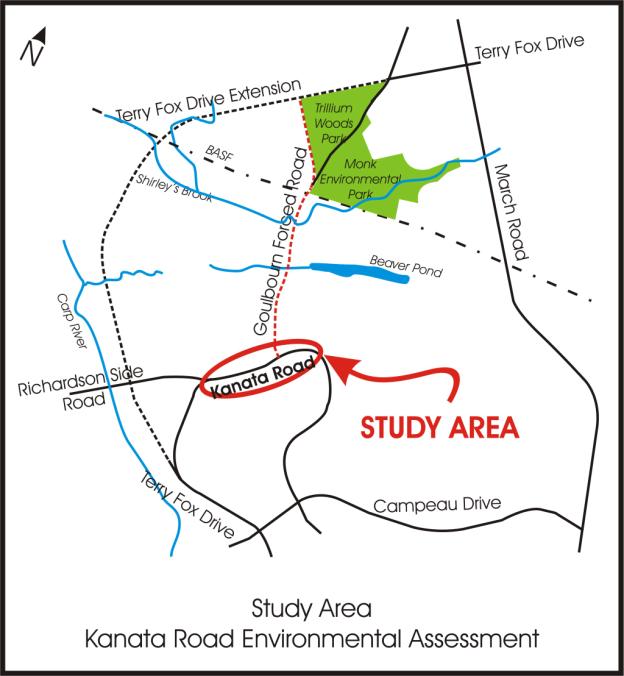
RECOMMENDED
PLAN AND
CROSS SECTION FOR KANATA AVENUE DOCUMENT
7