|
2. OFFICIAL PLAN AND
ZONING AMENDMENTS - 800 AND 848 CEDARVIEW ROAD AND
4497 O'KEEFE COURT
PLAN OFFICIEL ET ZONAGE - 800 ET 848,
CHEMIN CEDARVIEW ET 4497, COUR O'KEEFE
|
Committee recommendations as
amended
(This application is not subject
to Bill 51)
That Council :
1.
Approve and adopt an amendment to the Official Plan
Policy Section 3.2.6 to permit residentially zoned lands known as 800 and 848
Cedarview Road and 4497 O’Keefe Court which are located outside the urban
boundary to connect to the potable water service, as detailed in Document 2;
2.
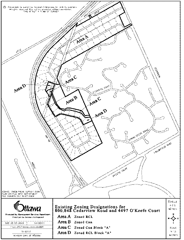
Approve an amendment to the former City of Nepean
Zoning By-law for 800 and 848 Cedarview Road and 4497 O’Keefe Court from RCL
Block "A", Residential Country Lots Zone, CON and CON Block
"A", Conservation Zone, as shown in Document 3, to RCL Blocks
"A" to "F", Residential Country Lots Zone, and CLC, Country
Lot Conservation Zone, and CON, Conservation Zone as shown in Document 4 as
revised to accurately reflect the necessary zoning change and detailed in
Document 5.
3. WHEREAS
the City of Ottawa is prepared to allow the extension of municipal water
services for a Country Lot Subdivision; and,
WHEREAS the Official Plan policies
provide some discretion with respect to Country Lot Subdivisions in Rural
Areas, and in an abundance of caution to avoid conflict with Official Plan
policies to Country Lot Subdivisions; and,
BE IT RESOLVED THAT Part B of OPA
no. 57 is hereby amended as follows to include Item 2: Notwithstanding the policies of
Sections 3.7.6 (c)(d)(e), the property known as known as 800 and 848 Cedarview
Road and 4497 O’Keefe Court, located abutting the urban boundary, can be
developed as a Country Lot Subdivision (with a golf course component), with one
(1) acre lot sizes, with a larger number of lots than 40, subject to
appropriate studies and municipal approvals.
RecommandationS modifiÉes du Comité
(Cette demande n’est
pas assujettie au Règlement 51)
Que le Conseil :
1. Approuve et
d’adopter une modification à la politique du Plan officiel, article, 3.2.6,
pour permettre aux terrains résidentiels se trouvant au 800 et au 848, chemin
Cedarview, ainsi qu’au 4497, Cour O’Keefe, lesquels sont situés à l’extérieur
du territoire urbain, de se raccorder au service alimentation en eau, comme le
précise le document 2;
2. Approuve
une modification au Règlement de zonage de l’ancienne ville de Nepean afin de
changer le zonage du 800 et du 848, chemin Cedarview, ainsi que du 4497, Cour
O’Keefe, de RCL pièce « A » (zone de lotissements de campagne résidentiels),
CON et CON pièce « A » (zone de conservation), comme l’indique le document 3, à
RCL pièces « A » à « F » (zone de lotissements de campagne résidentiels), ainsi
qu’à CLC (zone de lotissements de campagne de conservation) et à CON (zone de
conservation), en détail dans le document 4 tel
que révisé pour refléter précisément la modification de zonage nécessaire
et exposé en détail dans le Document 5.
3. Attendu
que la Ville d’Ottawa s’apprête à autoriser le prolongement des conduites d’eau
municipales vers un lotissement de domaine;
Attendu que les politiques du Plan
officiel laissent place à une certaine interprétation relativement aux
lotissements de domaine dans les secteurs ruraux, et dans un souci d’extrême
prudence pour éviter tout conflit avec les politiques du Plan officiel en ce
qui a trait aux lotissements de domaine;
Il est résolu que la partie B de la
MPO no 57 est par la présente modifiée de manière à ajouter l’article 2 suivant : Indépendamment des
politiques des sections 3.7.6 (c)(d)(e), la propriété située aux 800 et 848,
chemin Cedarview et au 4497, cour O’Keefe, contiguë à la limite urbaine, peut
être aménagée en lotissement de domaine (comprenant notamment un terrain de
golf), dont les terrains, d’un nombre supérieur à 40, auront une superficie
d’un (1) acre, sous réserve d’études et d’approbations municipales appropriées.
Documentation
1.
Deputy
City Manager's report Planning, Transit
and the Environment dated 29 October 2007 (ACS2007-PTE-APR-0164).
2.
Extract
of Draft Minutes, 13 November 2007.
Report
to/Rapport au :
Planning and Environment Committee
Comité de l'urbanisme et de l'environnement
29 October 2007 / le 29 octobre 2007
Submitted by/Soumis par : Nancy Schepers, Deputy City Manager
Directrice municipale adjointe,
Planning, Transit and the Environment
Urbanisme, Transport en commun et
Environnement
Contact Person/Personne ressource : Karen Currie,
Manager / Gestionnaire, Development Approvals / Approbation des demandes
d'aménagement
(613) 580-2424, 28310 Karen.Currie@ottawa.ca
|
|
Ref N°: ACS2007-PTE-APR-0164
|
|
SUBJECT:
|
OFFICIAL PLAN and zoning AMENDMENTs -
800 and 848 Cedarview Road and 4497 o'keefe court (FILE NO.'s D01-01-06-0010
and D02-02-06-0070)
|
|
|
|
|
OBJET :
|
PLAN OFFICIEL
et zonage - 800 et 848, chemin cedarview et 4497, cour o'keefe
|
REPORT
RECOMMENDATIONS
That the recommend Council:
1.
Approve and adopt an amendment to the Official Plan
Policy Section 3.2.6 to permit residentially zoned lands known as 800 and 848
Cedarview Road and 4497 O’Keefe Court which are located outside the urban
boundary to connect to the potable water service, as detailed in Document 2;
2.
Approve an amendment to the former City of Nepean
Zoning By-law for 800 and 848 Cedarview Road and 4497 O’Keefe Court from RCL
Block "A", Residential Country Lots Zone, CON and CON Block
"A", Conservation Zone, as shown in Document 3, to RCL Blocks
"A" to "F", Residential Country Lots Zone, and CLC, Country
Lot Conservation Zone, and CON, Conservation Zone as shown in Document 4 and
detailed in Document 5.
RECOMMANDATIONS DU RAPPORT
Que le Comité de l’urbanisme et de
l’environnement recommande au Conseil :
1.
d’approuver
et d’adopter une modification à la politique du Plan officiel, article, 3.2.6,
pour permettre aux terrains résidentiels se trouvant au 800 et au 848, chemin
Cedarview, ainsi qu’au 4497, Cour O’Keefe, lesquels sont situés à l’extérieur
du territoire urbain, de se raccorder au service alimentation
en eau, comme le précise le document 2;
2.
d’approuver
une modification au Règlement de zonage de l’ancienne ville de Nepean afin de
changer le zonage du 800 et du 848, chemin Cedarview, ainsi que du
4497, Cour O’Keefe, de RCL pièce « A » (zone de lotissements de
campagne résidentiels), CON et CON pièce « A » (zone de
conservation), comme l’indique le document 3, à RCL pièces « A » à
« F » (zone de lotissements de campagne résidentiels), ainsi qu’à CLC
(zone de lotissements de campagne de conservation) et à CON (zone de
conservation).
BACKGROUND
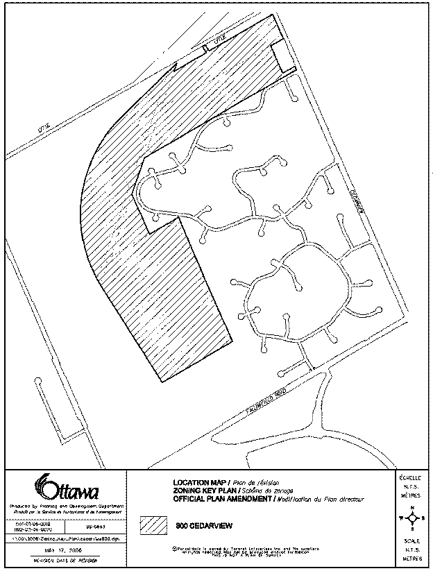
The subject property is located
east of Highway 416, north of Strandherd Drive and Fallowfield Road, and west
of Cedarview Road. This is an
"L" shaped parcel of land that runs along the east side of Highway
416 and is adjacent to the Cedarhill Estates and Orchard Estates residential
subdivisions. This parcel of land has
an area of 113.61 hectares. Some of the
features of this site include an abandoned quarry at the most westerly portion
of the property. The property is also
divided by a 12-metre wide hydro corridor that runs across the north-westerly
portion of the site. There is a City
park and vacant land to the south. To
the north is Lytle Avenue which is developed with single detached
dwellings. These lands were previously
rezoned Residential Country Lots, and Conservation to accommodate an approved
subdivision of 133 lots.
Purpose of the Official Plan and
Zoning Amendments
The purpose of this application
is to permit the development of a country-estate residential subdivision having
0.4 hectare lots. Proposed are 129
country-estate lots that will be partially serviced having municipal water
service with private septic systems.
Accompanying applications include a subdivision which has received draft
approval and which is currently under the 20 day appeal period. The appeal period ends on October 30,
2007. Proposed is an Official Plan
amendment for a site specific exception to allow partial municipal servicing
and a reduction in the minimum lot requirement of one-hectare lots. As well, a Zoning By-law amendment is
proposed to modify existing Residential Country Lots Zones, and Conservation
Zones to accommodate residential development, provide protection of
Provincially significant wetlands, and permit a golf course expansion and the
establishment of an executive golf course.
Proposed through the Zoning
By-law amendment is a Conservation Zone for publicly and privately owned
conservation lands. The purpose of the
Conservation Zone is to ensure the protection of the significant wetland area
and the provision of an adequate vegetative buffer to that wetland, ensuring
its viability.
The registered subdivision will contain
covenants for privately owned conservation lands prohibiting any physical
alteration to those lands including the removal of any vegetation. A preliminary Tree Planting and Conservation
Plan has been submitted identifying significant wooded areas to be
protected. A finalized plan will be
required prior to subdivision registration.
DISCUSSION
Official
Plan
The Official Plan designation for
this property is "General Rural Area" in Schedule "A" of
the Rural Policy Plan. The intent the
General Rural Area is permit land uses that are considered to be characteristic
and supportive of the rural community.
Provincial Policy Statement
The Provincial Policy Statement
promotes efficient development and land use patterns with the goal of attaining
cost-effective development that minimizes land consumption and servicing
costs. The applicable policy relating
to partial services permits only within settlement areas to allow for the
infilling and rounding of existing development, and only where there is reserve
sewage system capacity and reserve water system capacity, and where site
conditions are suitable for the long-term provision of such services.
Compatibility
The predominate land use in the
area can be characterized primarily as country estate residential lots with
some neighbouring public and private recreational uses. There are no lands within the immediate or
surrounding area whose function is agricultural or supportive of an
agricultural use. As such, the proposed
Official Plan and Zoning By-law amendments will not be in conflict with
Official Plan directives requiring residential development not detract from the
overall rural agricultural landscape, nor will there be potential for conflicts
between future rural/agricultural uses and the proposed residential uses. The expansion of the existing golf course
and the establishment of an executive golf course will mirror and enhance what
is now existing within the neighbouring established communities currently on
municipal water services. This overall
residential and recreational expansion is viewed to be an expansion to the
existing communities and is physically limited in area by Lytle Avenue to the
north, Cedarhill Road to the east, a City Park and Industrial lands to the
south, and Highway 416 to the west.
Natural Environment
Within the subject lands there
are a number of natural features which include a Provincially significant
wetland area, watercourses to the northeast, the O’Keefe Drain along the
south-easterly part of the subdivision that also includes City parkland, a
stand of cedars along the southerly edge of the wetland, a wooded area which
includes Butternut Trees adjacent to the Cedarhill Community, an abandoned
quarry which is now a water feature and a naturalized hydro corridor containing
a portion of an existing pedestrian pathway system.
Section 3.2 of the Official Plans
sets out policies and development practices to protect natural features such as
wetland areas, streams and wooded corridors, areas of High quality forests and
woodlands, and areas that contain fish habitat and significant wildlife
habitat. Shown within Document 4 and as
detailed in Document 5 are recommended zoning designations which will implement
the following zone designations:
· Refine
the boundary of the wetland and buffer, and zone Conservation, which will
prohibit any act that would in any way injure or negatively impact the
condition of the Conservation Land, including the removal of healthy trees.
· Zone
residential lots that are adjacent to areas identified as environmentally
sensitive areas, including such features as wetland areas, watercourses and
wildlife corridors, with site specific Residential Country Lot exception zones
in order to protect combinations of 15-metre vegetative buffers as no build zones
and implement a 15-metre to top of bank protective zone along watercourses and
wetland areas.
The remaining lands with be zoned
RCL, Residential Country Lot Zone, and CLC, Country Lot Conservation Zone, to
accommodate the development of a residential subdivision, an expansion to an
existing golf course, and the establishment of a new executive golf course.
Infill Areas
Official Plan policies relating
to residential lot development occurring within the General Rural Area require
that there be minimum lot areas of 0.8 hectares. There can be exceptions to this policy where residential
development is occurring within areas that are considered to be Infill
Areas. Notwithstanding minimum lot area
requirement of 0.8 hectares, Infill Areas may have reduced areas where the lot
sizing is in keeping with neighbouring residential lots. The neighbouring Communities of Cedarhill
and Orchard Park Estates are zoned Residential Country Lot Zones permitting
residential development on lots having minimum lot areas of 0.4 hectares on
lots partially serviced with municipal water.
The Lytle Avenue Community is zoned Residential Special Density Zone
permitting residential lot development on lots having a minimum lot area of
1,393 square metre. These properties
are unserviced having private water and septic systems.
Conclusion
This subdivision can be viewed as
the final build out of existing like communities bounded by Lytle Avenues to
the north, existing partially serviced residential development to the east, a
City park and industrial lands to the south and Highway 416 to the west. The existing water service in the area has
been analysed and found to have surplus capacity that can accommodate the
proposed 129 residential lot subdivision.
With respect to private septic systems, hydro-geological studies have
been submitted and accepted by the Rideau Valley Conservation Authority and the
City and these support the proposal for private septic systems. Staff recommend approval of the Official
Plan and Zoning By-law amendments required to implement the revisions to the
draft plan of subdivision.
ENVIRONMENTAL IMPLICATIONS
The Rideau Valley Conservation
Authority has reviewed the Official Plan, Zoning and Subdivision applications
and has no objections to these applications proceeding for approval. Issues relating to the wetland area have
been dealt with through draft conditions of subdivision approval and with site
specific exceptions to the zone designations.
RURAL IMPLICATIONS
There are no foreseen implications resulting from the
development of this subdivision.
CONSULTATION
Notice of this application was
carried out in accordance with the City's Public Notification and Consultation
Policy. The Ward Councillor is aware of
this application and the staff recommendation.
Issues raised by the public
primarily relate to the subdivision application and have been summarized and
responded to in Document 6.
FINANCIAL
IMPLICATIONS
N/A
APPLICATION PROCESS TIMELINE
STATUS
This application was not processed
by the "On Time Decision Date" established for the processing of
Official Plan and Zoning By-law amendments due to the complexity of the issues
associated with the natural environmental features occurring on these lands.
SUPPORTING
DOCUMENTATION
Document 1 Location Map
Document 2 Proposed Official Plan Amendment
Document 3 Current Zone Designations
Document 4 Proposed Zone Designations
Document 5 Details of Proposed Zonings
Document 6 Consultation Details
DISPOSITION
City Clerk’s Branch, Council and Committee
Services to notify the owner, Noel Perera, 2880 Sheffield Road, Unit 3,
Ottawa, ON, K1B 1A4, applicant, FoTenn Consultants Inc., 223 McLeod
Street, Ottawa, ON, K2P 0Z8, Signs.ca, 866 Campbell Avenue, Ottawa, ON K2A 2C5, Ghislain Lamarche, Program Manager,
Assessment, Financial Services Branch (Mail Code: 26-76) of
City Council’s decision.
Planning,
Transit and the Environment Department to prepare the by-law adopting
the Official Plan Amendment, and prepare to implementing Zoning By-law, and
forward to Legal Services Branch, and undertake the statutory notification.
Legal Services Branch to forward the
implementing by-law to City Council.
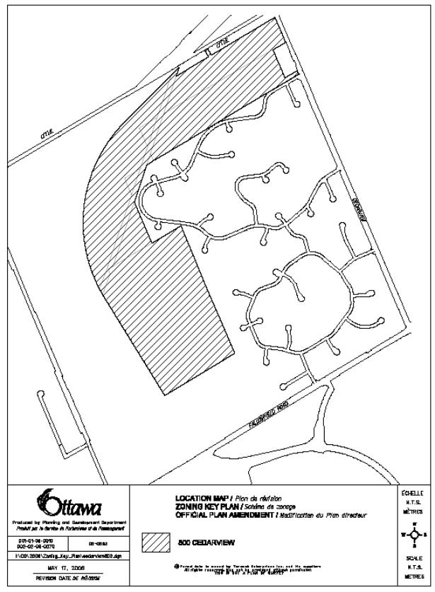
LOCATION MAP DOCUMENT
1
DOCUMENT 2
PROPOSED OFFICIAL PLAN
AMENDMENT
Official Plan Amendment 57/Modifications du Plan
directeur
To the
Official Plan of the City of Ottawa
Land use
Utilisation du sol
OFFICIAL PLAN AMENDMENT
AMENDMENT No. 57 TO THE CITY COUNCIL APPROVED OFFICIAL PLAN
INDEX
COMPONENTS
PART A – THE PREAMBLE
PART B –
THE AMENDMENT
1.0
Introduction
2.0
Details
3.0
Implementation
COMPONENTS
PART A - THE PREAMBLE does not constitute part of this
amendment.
PART B - THE AMENDMENT,
consisting of the following text constitutes Amendment No. 57 to
the City of Ottawa Council Approved Official Plan.
PART A - THE PREAMBLE
Purpose
The
purpose of Amendment 57 is first to amend Schedule “1” of the Official
Plan from General Rural Area to Country Lot and Open Space.
Location
The
property is located east of Highway 416, north of Strandherd Drive and
Fallowfield Road, and west of Cedarview Road.
This parcel of land has an area of 113.61 hectares. Surrounding area development consists of
residential development along Lytle Avenue, Cedarhill Estates and Orchard
Estates residential subdivisions, and the Cedarhill Golf Course to the east and
a city recreational park and vacant land to the south, and Highway 416 to the
west. The property is also divided by a
12-metre wide hydro corridor that runs across the northwesterly portion of the
site.
Basis
The
subject property is designated as General Rural on Schedule “A” in the City of
Ottawa’s Official Plan and is subject to the Official Plan’s Rural
policies. In the Official Plan the
General Rural designation is for lands that have less resource potential that
other parts of the rural area. The plan permits residential development within
the General Rural designations on large country estate lots of not less than
0.8 hectares provided there is evidence of satisfactory private water and
septic services on site.
A conceptual stormwater management plan, and a terrain
analysis and hydrogeological study submitted with the subdivision application,
demonstrated that the subject lands can support the subdivision proposal for
129 lots of 0.4 hectares on municipal water and private septic. Additionally, a
review of the proposal was found to be in keeping with the overall intent of
the applicable Official Plan policies and guidelines for country lot
subdivision development.
PART B - THE AMENDMENT
1. INTRODUCTION
All
of this part of the document entitled Part B - The Amendment, consisting of the following text constitutes Amendment No. 57
to the City Council Approved Official Plan.
2. DETAILS
That the City Council Approved Official Plan is
hereby amended as follows:
1. Subsection
2.3.2. of the Official Plan is hereby amended by adding the following new
policy 8 at the end of Policy 8:
“Notwithstanding the policies of Section 2.3.2, the
properties known municipally as 800 and 848 Cedarview Road, and 4497 O’Keefe
Court (legally defined as Part of Lots 22, 23, 24 and 25, Concession 4, Rideau
Front, former City of Nepean), located outside the urban boundary, is permitted
to connect to the potable water service.”
2. “The subsequent policies are renumbered as
required.”
3. IMPLEMENTATION
The implementation of this
Amendment to the Official Plan document shall be in accordance with the
respective policies of the Official Plan of the City of Ottawa.
CURRENT ZONE DESIGNATIONS DOCUMENT
3
PROPOSED ZONE DESIGNATIONS REVISED
DOCUMENT 4
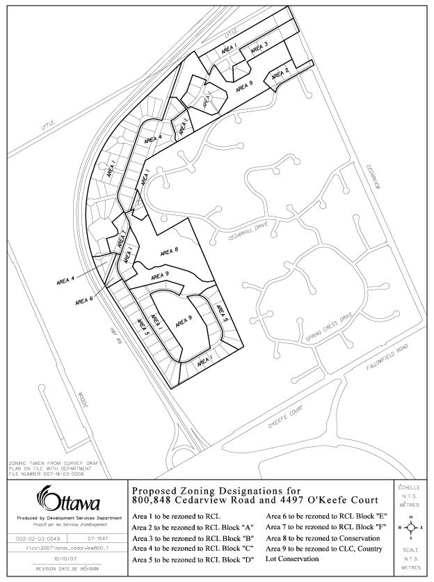
DETAILS OF PROPOSED
ZONINGS DOCUMENT
5
1.
That Area 1 be rezoned to RCL.
2.
That the text of Section 7.4 1) be deleted and replace with
the following:
7.4 1) Exceptions
Despite
7.2 on lands zoned RCL Block “A” there shall be no on-site alteration within
15.0 metres from the “top of bank” of a watercourse with the exception of a
driveway.
3. That Area 2 be rezoned to RCL Block “A”.
- That
Area 3 be rezoned to RCL Block “B”, with Block “B” denoting the following
exception to the standard RCL zone:
7.4
2) Exceptions
Despite 7.2 on lands zoned RCL Block “B” there shall be
no on-site alteration within 15.0 metres from the “top of bank” of a
watercourse.
5. That
Area 4 be rezoned to RCL Block “C”, with Block “C” denoting the following
exception to the standard RCL zone:
7.4
3) Exceptions
Despite 7.2 on lands zoned RCL Block “C”
there shall be no on-site alteration within 15.0 metres from the Hydro
Corridor.
6. That Area 5 be
rezoned to RCL Block “D”, with Block “D” denoting the following exception to
the standard RCL zone:
7.4
4) Exceptions
Despite 7.2 on lands zoned RCL Block “D” there shall be
no on-site alteration within 15.0 metres from the rear property line.
7. That Area 6 be
rezoned to RCL Block “E”, with Block “E” denoting the following exception to
the standard RCL zone:
7.4
5) Exceptions
Despite
7.2 on lands zoned RCL Block “E” there shall be no on-site alteration within
15.0 metres from the rear property line and 15.0 metres from the Hydro
Corridor.
8. That Area 7 be
rezoned to RCL Block “F”, with Block “F” denoting the following exception to
the standard RCL zone:
7.4
6) Exceptions
Despite
7.2 on lands zoned RCL Block “F” there shall be no on-site alteration within
15.0 metres from the Hydro and 15.0 metres from a watercourse.
9. That
Area 8 be rezoned to Con, Conservation Zone.
10. That Subsection 1)
of Section 9.6 be deleted.
11. That Area 9 be
rezoned to CLC, Country Lot Conservation Zone.
CONSULTATION DETAILS DOCUMENT
6
This application was subject to the Public
Notification and Consultation Policy.
Enhanced notification was carried out and included numerous meetings
with the Cedarhill and Orchard Park Community Associations.
PUBLIC COMMENTS
The following is a summary of comments expressed at the
mandatory public meeting for the subdivision application that accompanied the
applications to amend the Official Plan and Zoning By-law applications. This meeting was held on April 10, 2007 at
the Cedarhill Golf Course Clubhouse.
Discussions at this meeting primary focused on the subdivision
application.
Summary
of Questions and Answers
· First question raised was whether or
not any of the remnant lands from the reworked/retired fairways will be
subdivided into residential lots?
Response
– This would not be occurring but if it did, the Golf Course would have to
first apply for a rezoning and severance applications with the City.
· Numerous questions were raised
relating the existing water pressure, existing municipal reservoirs and pumping
stations and a question as to whether the Water Servicing Analysis made any
assumptions regarding existing municipal water facilities.
Response
- Stantec representatives provided supporting extensive technical responses to
address these concerns, including a discussion concerning water pressure boosts
from pumping stations as the water level drops in the water tower, and
concluded that water pressure will not be affected by the servicing of the
proposed subdivision. If anything, the
water pressure will be improved with the introduction of looping with the
existing infrastructure by reducing dead end water lines.
· A member of the audience asked why
the City was extending municipal water servicing to this subdivision whereas
not for subdivisions in the Greely area
Response
– The decision whether or not to
allow municipal water service is reviewed on a case-by-case basis. This development is unique in that water
service is immediately available and represents an expansion to an existing
community currently being serviced by municipal water.
· A question was raised about water
levels and the quality of stormwater flowing
into the wetland.
Response
– City Staff indicated that the over land flows of surface water to the wetland
will be maintained. Note: the RVCA has since taken the position that
the wetland will no longer have a stormwater management component.
· A concern was expressed about the
alteration of existing drainage patterns and an increase risk of the flooding
for Lytle Avenue residents.
Response
– City staff assured that existing over land water flows will be maintained
with no increase to the risk of flooding.
· There was follow-up Lytle Avenue
question regarding what the development’s impact on existing area well and
septic systems would be.
Response
- A Hydrogeological and Terrain Analysis was submitted with the subdivision
application which considers such impacts within the proposed subdivided lands
and those surrounding area lands potentially affect by the development of the
subdivision. This analysis has been
reviewed and accepted by the City and the RVCA concluding that there will be no
anticipated adverse impacts to the ground water that will affect existing wells
or septic systems.
· A Cedarhill resident asked about
collect backs to the Cedarhill residents who, paid on a yearly basis, a tax
surcharge to bring in municipal water service by the City.
Response
– The City's legal opinion is that collect backs would not be applicable in
this case because it is now municipally serviced and the City, where
appropriate, is required to extend the service to those developers who request
it.
· Questions were raised regarding tree
protection within the subdivision, particularly with respect to the wetland and
the cedars along the northerly side of Cedarhill Drive where in intersects
Cedarhill Road.
Response
– A tree preservation plan has been prepared identifying wooded areas worthy of
protection which includes various noted areas along the wetland area which have
since been deemed as vital to the functionality of the wetland itself by the
RVCA, as well as, a treed wildlife corridors that are to be protected. With respect to the cedar grove along
Cedarhill Drive, there are subdivision conditions to be put in place which will
limit any disturbances of driveways for lots 38 to 41 and will additionally
require an approval from the RVCA.
· A related question to the stands of
cedars along Cedarhill Drive was whether the watercourse adjacent to those
cedars will be protected.
Response
– A number of potential watercourses have been identified by the RVCA and there
are numerous conditions incorporated into the subdivision approval from the
Conservation Authority to ensure the protection of these watercourses.
· There was a concern that through the
development of the subdivision, sound will be transmitted into the neighbouring
subdivisions from Hwy 416.
Response
- A Noise Study had been prepared which identifies that only the westerly side
of the subdivision required the introduction of sound attenuation measures by
either berming, sound fencing or a combination of both. Sound attenuation
was not required along the north-westerly proportion of the subdivision due to
the extent of the Hwy 416 road cut which will act as a natural sound
barrier. Because of the introduction of
sound attenuation along the westerly portion of the subdivision, existing sound
levels emanating from Hwy 416 will only be reduced as a result of the
subdivision’s requirement for sound attenuation along that portion of the 416. Lots adjacent to the 416 within the
subdivision will have standard warning clauses the there may be times within
the day that exterior noise levels may exceed 60 db.
· Questions were raised about how much
new parkland will provided in the community.
Response
– As per the previous plan of subdivision approval, Blocks 130 and 147 will be
conveyed to the City as parkland dedication and allow an expansion of an
adjacent park within the Cedarhill Community.
This expansion will come with improvements to the park with the addition
of a swing set within the expanded park and a basketball net within the
emergency vehicle access on Block N.
Councillor Harder indicated she also intends to take the cash-in-lieu of
parkland collected from this subdivision and earmark it for a pathway within
Block 141 terminating at an outlook feature onto the wetlands. Subsequently an additional block (Block 130)
at the south end of the subdivision, approximately one acre, has been created
and is to be dedicated as parkland. A
second park is also planned at the southern end of the subdivision identified
as Block 149 on the revised plan of subdivision.
· One resident from the Orchard Estates
Community inquired as to whether or not there are any proposed pathway links
from the subdivision into her community.
Her concern is that these pathway linkages become dumping grounds for
garbage.
Response
– Although the plan of subdivision does not contemplate an immediate pathway
linkage it does reserve Block 146 for a potential future pathway link to that
community should that community desire a linkage in the future.
· Questions were raised regarding
blasting for roadwork and foundation construction, whether or not there will be
compensation to existing residents that may incur damage from the blasting and
whether there be notice given prior to any blasting work being conducted.
Response
– Blasting work is regulated by the Province and notice will be given in a
timely fashion to a set radius where that blasting is to occur. In addition, it is in the interest of the
developer to inspect for pre and post-building conditions within area
potentially affected by the blasting activity for insurance purposes. There will be conditions within the
subdivision for the developer and individual builders to provide advance notice
prior to any blasting work.
· The Cedarhill Community inquired as
to what will become of Block 133 suggesting that the developer use these lands
to construct an entrance feature to the Cedarhill Community similar to the
southeast corner of Cedarhill Drive and Cedarhill Road.
Response
– It has been subsequently identified that the existing entrance feature is
occurring within the municipal road allowance.
Subsequently Council has directed that entrance features will not be
permitted with the City’s road allowances.
The developer is open to erecting a similar entrance feature within
Block 133. It should be noted that, as
a condition of subdivision approval, Block 133 will be deleted the plan and
become part of Lot 38 due to the fact that in creating Block 133 it will result
in a substandard parcel of land which the City can not support.
· The Orchard Park Community requests
that there be a road connection between the Cedarhill Community and the
proposed subdivision through Block N to establish vehicular connectivity
between the three communities.
Response
– It has been the Cedarhill Community’s firm position that as in the previous
draft plan of subdivision approval and as with this subdivision approval that
there only be a emergency vehicle link through Block N which had been reflected
as such within that original draft plan approval.
· As a follow-up question, the Orchard
Park Community would like to see a second road into the subdivision from the
south at Lot 100.
Response
– The adjacent lands to the south are zoned and proposed to be developed for
non-residential, rural-industrial uses
that do not support the concept of a road linkage with this estate-lot
subdivision.
Community
Associations
At
a meeting held on September 10, 2007, the executives of the Cedarhill and
Orchard Park Estate Community Associations indicated they had no objections to
the approval of the final proposed subdivision.
OFFICIAL PLAN AND ZONING AMENDMENTS - 800 AND
848 CEDARVIEW ROAD AND 4497 O'KEEFE COURT
PLAN OFFICIEL ET ZONAGE - 800 ET 848, CHEMIN
CEDARVIEW ET 4497, COUR O'KEEFE
ACS2007-PTE-APR-0164 BARRHAVEN
(3)
(This application is not
subject to Bill 51)
Councillor Harder moved two amendments to the
departmental recommendations, which were concurred with both the applicant
represented by Miguel Tremblay, FoTenn Consultants and Karen Currie,
Manager of Development Approvals East/South.
Moved
by J. Harder:
WHEREAS
Document 4 of the Planning and Environment Committee report ACS2007-PTE-APR-0146
does not accurately reflect the necessary zoning change;
AND
WHEREAS the revision to the said Document 4 is necessary to make the
appropriate zoning amendment;
THEREFORE
BE IT RESOLVED THAT Planning and Environment Committee approve the deletion and
substitute replacement of Document 4.
That no further notice be
provided pursuant to Section 34 (17) of the Planning Act.
CARRIED
Moved by J. Harder:
WHEREAS the City fo Ottawa is prepared to allow the extension of
municipal water services for a Country Lot Subdivision;
AND WHEREAS the Official Plan policies provide some discretion with
respect to Country Lot Subdivisions in Rural areas, and in abundance of caution
to avoid conflict with Official Plan policies to Country Lot Subdivisions;
BE IT RESOLVED THAT
Part B of OPA no. 57 is hereby amended as follows to include Item 2: Notwithstanding the policies of
Sections 3.7.6 (c)(d)(e), the property known as known as 800 and 848 Cedarview
Road and 4497 O’Keefe Court, located abutting the urban boundary, can be
developed as a Country Lot Subdivision (with a golf course component), with one
(1) acre lot sizes, with a larger number of lots than 40, subject to
appropriate studies and municipal approvals.
CARRIED
That the
Planning and Environment Committee recommend Council:
1.
Approve and adopt an amendment to the Official Plan
Policy Section 3.2.6 to permit residentially zoned lands known as 800 and 848
Cedarview Road and 4497 O’Keefe Court which are located outside the urban
boundary to connect to the potable water service, as detailed in Document 2;
2.
Approve an amendment to the former City of Nepean
Zoning By-law for 800 and 848 Cedarview Road and 4497 O’Keefe Court from RCL
Block "A", Residential Country Lots Zone, CON and CON Block
"A", Conservation Zone, as shown in Document 3, to RCL Blocks
"A" to "F", Residential Country Lots Zone, and CLC, Country
Lot Conservation Zone, and CON, Conservation Zone as shown in Document 4 as
revised to accurately reflect the necessary zoning change and detailed in
Document 5.
3. WHEREAS the
City of Ottawa is prepared to allow the extension of municipal water services
for a Country Lot Subdivision;
AND
WHEREAS the Official Plan policies provide some discretion with respect to
Country Lot Subdivisions in Rural Areas, and in an abundance of caution to
avoid conflict with Official Plan policies to Country Lot Subdivisions;
BE IT
RESOLVED THAT Part B of OPA no. 57 is hereby amended as follows to include Item
2: Notwithstanding the policies of
Sections 3.7.6 (c)(d)(e), the property known as known as 800 and 848 Cedarview
Road and 4497 O’Keefe Court, located abutting the urban boundary, can be
developed as a Country Lot Subdivision (with a golf course component), with one
(1) acre lot sizes, with a larger number of lots than 40, subject to
appropriate studies and municipal approvals.
CARRIED as amended