|
1. North Gower Community Design Plan – official plan and zoning
amendments (file no. d02-07-0024, file no. d01-01-06-0012) PLAN
DE CONCEPTION COMMUNAUTAIRE DE North Gower –
modification du plan officiel et du zonage
|
COMMITTEE RECOMMENDATIONS AS AMENDED
That Council:
1. Approve the North Gower Community
Design Plan (Document 1 – On file with the City Clerk),
2. Approve
City of Ottawa Official Plan __
Amendment [Document 2] to:
a) Remove the North Gower Village Plan from Volume 2C of the Official Plan,
b)
Revise City of
Ottawa Official Plan Schedule A – Rural Policy Plan to revise the North Gower
village boundaries and to redesignate lands from “Agriculture Resource Area”
and “General Rural Area” to “Village”.
3.
Approve an
amendment to the Draft Comprehensive Zoning By-law as shown on the location
maps and as detailed in Document 3.
4. Approve that Schedule A – Land Use be amended so that the
portion of the Stevens Creek flood plain located west of Fourth Line Road,
south of Roger Stevens Drive and north of Church Street be changed to extend
the “Agriculture” land use designation (green colour) westward to the village
boundary; and
5. Approve that the North Gower
Community Design Plan be brought back to committee in a Secondary Plan format
and be incorporated in the Official Plan.
RecommandationS MODIFIÉES du Comité
Que le Conseil municipal :
1.
Approuve le plan de conception
communautaire de North Gower (document no 1 au dossier, auprès du
greffier de la Ville).
2.
Approuve la modification _ du Plan officiel
de la Ville d’Ottawa (document no 2) en :
a)
retirant le plan du village de North Gower
du volume 2C du Plan officiel.
b) milieu rural, afin de
modifier la limite nord du village de North Gower et de reclasser les terrains
désignés « terres agricoles » et « secteur rural général »
en « Village ».
3.
Approuve la modification du projet de Règlement de zonage général telle qu’indiquée
sur les plans d’emplacement et précisée dans le document 3.
4. Approuve la modification de l’annexe A – Utilisation du
territoire afin que la désignation de la section des plaines inondables du
ruisseau Steven situées à l’ouest du chemin Fourth Line, au sud de la promenade
Roger-Stevens et au nord de la rue Church, soit modifiée en vue de prolonger la
désignation « agricoles » des terrains (couleur verte) vers l’ouest,
jusqu’aux limites du village;
5. Approuve une nouvelle présentation du Plan
de conception communautaire de North Gower devant le Comité sous la forme d’un
plan secondaire et qu’il soit intégré au Plan officiel.
DocumentatioN
1.
Deputy
City Manager's report Planning, Transit
and the Environment dated 8 November 2007 (ACS2007-PTE-POL-0046).
2. Extract of draft Minutes, 10 January 2008.
Report to/Rapport au :
Agriculture and Rural Affairs Committee
Comité d'agriculture et des questions rurales
and Council / et au Conseil
08 November 2007 / le
08 novembre 2007
Submitted by/Soumis par Nancy Schepers, Deputy City Manager /
Directrice municipale adjointe,
Planning, Transit and the Environment
/ Urbanisme, Transport en commun et Environnement
Contact
Person/Personne Ressource : Richard Kilstrom, Manager / Gestionnaire,
Development Approvals / Approbation des demandes d'aménagement
(613)
580-2424, 22653
Richard.Kilstrom@ottawa.ca
REPORT
RECOMMENDATIONS
1. Approve
the North Gower Community Design Plan (Document 1 - On file with City Clerk),
2. Approve City of Ottawa Official Plan __
Amendment [Document 2] to
a) Remove
the North Gower Village Plan from Volume 2C of the Official Plan,
b) Revise City of Ottawa Official Plan Schedule A - Rural Policy Plan to revise the North Gower village boundaries and to redesignate lands from "Agricultural Resource Area" and "General Rural Area" to "Village"
3. Approve an amendment to the Draft Comprehensive Zoning By-law
as shown on the location maps and as detailed in Document 3.
RECOMMANDATIONS DU RAPPORT
Que le Comité de l’agriculture et des questions rurales recommande au
Conseil :
1. D’approuver le plan de
conception communautaire de North Gower (document no 1 au dossier,
auprès du greffier de la Ville).
2. D’approuver la modification
_ du Plan officiel de la Ville d’Ottawa (document no 2) en
a)
retirant le plan du village de North Gower
du volume 2C du Plan officiel.
b) milieu rural, afin de
modifier la limite nord du village de North Gower et de reclasser les terrains
désignés « terres agricoles » et « secteur rural général »
en « Village ».
3. D’approuver la modification
du projet de Règlement
de zonage général telle qu’indiquée sur les plans d’emplacement et précisée
dans le document 3.
EXECUTIVE SUMMARY
Assumptions
and Analysis:
The North Gower Community Design Plan (CDP) is
a result of a collaborative planning process that has included residents,
property owners, technical staff/agencies and staff. The North Gower CDP is comprised of various components consisting
of: i) existing conditions ii) a land
use plan that identifies the proposed location of future uses and associated
policies, iii) a parks and open space plan that will assist developers and
staff in identifying future park locations resulting from the subdivision
approval process, iv) a multi-use pathway plan that identifies a conceptual
system that can be implemented by residents, developers, and City and v) a
future roads plan that identifies a conceptual collector road system that will
help to connect the village together.
The North Gower CDP is a document that reflects the future desired by its residents. Staff has incorporated residents’ comments, concerns and results of their work into the plan. The CDP tries to implement the vision set out by residents at the outset of the planning process and will be used equally by residents and staff in their respective projects and work.
Financial
Implications:
There are no immediate and direct financial implications associated with the approval of the North Gower CDP.
Public
Consultation/Input:
Consultation with residents included a workshop, public meetings/open houses, and separate meetings with the Design Group (interested residents who helped to initiate the village plan). Early on during the planning process, staff experts were also invited to speak at meetings to present ideas and to receive feedback from residents. Copies of draft documents were left at locations in the village to make it more convenient for residents.
This spring staff circulated to interested residents a summary of public and draft Departmental responses to the December 2006 version of the North Gower CDP so that residents would be aware of the range of comments and staff’s response to them. A further round of comments and revisions ensued which has resulted in the North Gower CDP (November 2007) and associated recommendations.
RÉSUMÉ
Hypothèses et analyse :
Le Plan de conception communautaire de North
Gower (PCC) est le résultat d’un processus de planification avec la
collaboration des résidents, des propriétaires fonciers, d’agences et de
personnel techniques et du personnel de la Ville. Le PCC de North Gower
comporte plusieurs composantes, à savoir : i) la situation actuelle, ii)
un plan d’utilisation des terres qui indique l’emplacement futur envisagé pour
les diverses utilisations et les politiques pertinentes, iii) un plan des parcs
et des espaces libres qui permettra aux promoteurs et au personnel de repérer
l’emplacement futur des parcs à la suite du processus d’approbation des
lotissements, iv) le plan d’un sentier polyvalent qui propose un concept
pouvant être mis en place par les résidents, les promoteurs et la Ville, et, v)
un plan des toutes les futures routes, basé sur un concept de routes
collectrices permettant de desservir le village.
Le PCC de North Gower est le reflet de ce que
ses habitants souhaitent pour l’avenir. Le personnel a incorporé les
commentaires des résidents, leurs préoccupations et le résultat de leur travail
dans le plan. Le PCC cherche à mettre en œuvre la vision définie par les
résidents dès le début du processus de planification et sera utilisé tout aussi
bien par eux que par le personnel pour réaliser les divers projets et faire le
travail.
Répercussions financières :
L’approbation du PCC de North Gower ne comporte aucune répercussion
financière immédiate et directe.
Consultation publique/Commentaires :
Les consultations avec les résidents ont pris
la forme d’un atelier, de réunions publiques et de réunions distinctes avec le
Groupe de conception, composé de résidents intéressés qui ont contribué à
l’élaboration du plan du village. Au début du processus de planification, on a
également invité des experts aux réunions afin qu’ils expliquent les idées
proposées et reçoivent les commentaires de la population. Des copies des
documents préliminaires ont été déposées à divers endroits dans le village afin
que les habitants puissent les consulter plus facilement.
Ce printemps, le personnel a diffusé aux
résidents intéressés un sommaire des commentaires du public et les réponses
préliminaires du Service au sujet de la version de décembre 2006 du PCC de
North Gower, de façon que les gens soit au courant de toute la gamme des
commentaires et de la réponse du personnel. Il s’en est suivi une autre série
de commentaires et de révisions qui ont finalement abouti au PCC de North Gower
(décembre 2007) et aux recommandations correspondantes.
BACKGROUND
The North Gower Community Design Plan (CDP) is a planning document that will provide direction for the future growth of North Gower while it implements Official Plan policies at the community level. It is a document that identifies issues that are important to residents and provides a framework for change. The North Gower CDP was prepared at the request of village residents who wished to have a plan that would reflect the unique character of their community and would set a direction for the next 20 years. The planning process has been a truly collaborative process that was built on a preliminary plan prepared by a group of residents (Design Group) based on a vision with the input of fellow villagers. In mid-2004, City staff was asked for their assistance with their plan.
Initial work was required to develop an understanding of the existing conditions of the village including matters such as natural systems, planning context, heritage resources, and servicing. Staff organized meetings with the Design Group and staff experts were invited to meetings to present findings (e.g. natural environment and Stevens Creek and flood plain mapping), to solicit input (e.g. North Gower groundwater study) or to discuss approaches that could be undertaken in the CDP (how to maintain built heritage).
In mid-June 2005, a public meeting/workshop was held where staff presented findings and asked residents to provide feedback regarding the community vision and draft goals and objectives that would serve as a guide in developing a plan for North Gower.
Many proposals originally developed by the Design Group, with further refinements and input from technical staff, were incorporated into the CDP. Staff worked in consultation with the Design Group who provided feedback with regard to the development of a parks and open space plan, multi-use pathway plan, heritage design guidelines, environmental matters and an assessment of the village’s groundwater conditions. All of this work was incorporated into the draft North Gower CDP. This CDP was presented to the public during an open house/public meeting on June 20, 2006 and as a result of comments, a revised draft CDP (December 2006) and zoning changes to the Draft Comprehensive Zoning By-law were prepared for a public meeting/open house in January 2007. This meeting resulted in further public comments that have gone into the revisions resulting in the North Gower CDP found in Document 1.
DISCUSSION
The North Gower CDP is based on a community
vision created by residents outlining the future desired with the following
over-arching goals:
§
To
manage growth in an orderly way that fosters economic opportunities while
providing for a mix of housing for residents recognizing its rural setting.
§
To
preserve and enhance the village’s natural features, historic character, open
spaces and amenities in order to build upon residents’ sense of community.
§
To
ensure that village residents’ safety and security is provided for and that
there is adequate infrastructure services to permit growth.
Overview of Community Wishes/Concerns
Design Group and residents’ wishes and concerns
were identified throughout the planning process and were addressed in a variety
of ways. The following identifies the
issues encountered during creation of the North Gower CDP and how they were
resolved.
§
Village boundary
expansion - The Design Group
proposed to extend the village boundaries to include existing settlement areas
located outside North Gower, farmlands and other lands. Staff evaluated each location and identified
those areas where they were in agreement.
The village and expansion areas then became the planning area for the
North Gower CDP.
§
Enhance
village core – Residents and the Design Group
commented on the limited number of businesses that serve the day-to-day needs
of residents and visitors as well as the appearance of the core. The North
Gower CDP includes a Land Use Plan – Schedule A that proposes a range of
commercial and residential uses for this area and a Village Plan that
identifies ways that the village core can be enhanced.
§ Future commercial area near core – The Design Group wanted to identify a future commercial area, within proximity of the village core that could accommodate a neighbourhood-serving use (e.g. grocery store) that would require more land than is available in the village core. Since there are no known plans for such a development, it was not possible to show an exact location. Therefore a symbol is shown on the Land Use Plan to identify a conceptual location.
§ Maintenance of village’s history and character – This was important to residents who were interested in ways to retain the rural character and history of their community. This was achieved in development of heritage design guidelines for residential and commercial buildings in the village core, a proposal for future street names to reflect village history, and development of policies for future residential development that would reflect its rural setting.
§
Future residential uses – At the request of the
Design Group, staff agreed to review the future of undeveloped farmland in the
village since the current village zoning shows it zoned as “future development”
and it is usually only changed after consideration of a development
application. In the CDP, staff
proposed “residential” as the future use of these lands and has identified a
minimum lot size.
- Zoning of existing neighbourhoods – A number
of residents were concerned that the Draft Comprehensive Zoning By-law
will permit two-unit development in some neighbourhoods that now only
allow single detached dwellings and existing two-unit
development. Staff has identified
proposed zoning changes to the Draft Comprehensive Zoning By-law to permit
primarily single detached dwellings.
§
Agricultural uses in flood plain – Design Group
members were concerned that farming and farmstands would not continue to be
permitted in the flood plain in the future.
The zoning has been revised to permit these types of uses in the flood
plain.
§ Creation of a formal multi-use pathway system – Initially spearheaded by the Design Group, there was a desire for a village-wide pathway system incorporating existing informal pathways situated on private land. Some property owners did not want these conceptual pathways shown on their lands so staff subsequently deleted portions of the conceptual lines, but the concept of a village wide system is still maintained.
§ Servicing the core – The Design Group wanted the City to explore the use of ”servicing the core” to encourage businesses to locate in North Gower. In order that the request be dealt with in more comprehensive manner, staff encouraged members to participate in the rural settlement strategy, as part of the Official Plan five-year review, to discuss this issue with other rural residents living in villages.
- Sidewalks, transit, lighting –Area and site
specific concerns were identified by residents. Sidewalk improvements were factored into the Multi-Use
Pathway Plan and staff has identified these concerns in the CDP and
identified contacts and steps for residents to pursue their concerns.
- North Gower CDP versus Secondary Plan - There
has been discussion as to whether the North Gower CPD should be approved
as a secondary plan. This has led
to a separate staff report that will specifically deal with the issue and
recommend actions to Planning and Environment Committee and to the
Agriculture and Rural Affairs Committee for consideration and approval by
City Council.
RECOMMENDATION 1. – Approve
North Gower Community Design Plan
It is recommended that the North Gower CDP be approved by City
Council. This document provides
direction for future development in the village, while implementing the
Official Plan. Major components of the
plan are discussed below and include: a
land use plan, parks and open space plan, multi-use pathway plan, village
centre plan and future roads plan.
North Gower CDP
At the outset of the project, the Design Group wanted staff to
re-evaluate the current village boundaries, some of which do not follow any
distinguishable lot line, or natural features.
After a thorough review, staff agreed that some of the boundaries could
be modified and as a result the planning area was modified (see village
boundary expansion discussion under Recommendation b)).
i) Land
Use Plan
A major component of the North Gower CDP is the land use plan, which
identifies the future use of lands and provides associated policies. The Land Use Plan is comprised of the land
uses described below:
The Village Centre is the focus of commercial activity for the village. The majority of commercial activity will take place in this area, which is centred on Roger Stevens Drive and Fourth Line Road, but will also include the North Gower Farmer’s Market, a major attraction in the village. In this designation, buildings will be located close to the sidewalk and there will be a mix of uses (commercial, residential), located either in adjacent buildings or within the same building. A range of main street – type uses, as well as residential uses, will be permitted so that it will be easier for uses to transition to other complementary uses without the need for Zoning By-law amendments. There are a few properties that are located a short distance from the commercial core, but the implementing zoning will reflect their location in a residential neighbourhood.
There are other types of
commercial designations shown on Schedule A – Land Use. The Local Commercial designation
recognizes limited commercial uses that located outside the Village Centre. The uses in this designation are located
away from the Village Centre area and include uses such welding and repair that
are not found in the core. The Highway
Commercial designation applies specifically to those lands at the
intersection of Highway 417 and Roger Stevens Drive. This designation, which is
located closest to the 417, accommodates commercial uses that require good
highway connections, visibility and larger parcels of land than is found in the
Village Centre. To the west of this
area, is the Industrial designation that will accommodate industrial
uses that are also dependent on good highway access, larger parcels of land and
highway visibility. At the specific
request of the Design Group, a Future Commercial symbol is shown on the
Land Use schedule to show a conceptual location of future neighbourhood-serving
use, such as a grocery store needed to serve residents of the village, that
could be located close to the Village Centre requiring more land than would be
available along the main street. It
should be noted that should such a use be proposed, a rezoning and associated
public review process must still be undertaken to identify the specific
location and proposed uses.
The Residential land use applies to development land (farmland) and existing neighbourhoods in North Gower. In many villages development land is not zoned until a zoning application has been considered by City Council. However, the Design Group wanted the future use of these undeveloped lands to be determined in the context of the CDP. It was agreed that a Residential designation, that accommodates single detached dwellings, was the most appropriate use for these lands after discussions among staff, Design Group and residents. For the development land, due to the fact that lands are privately serviced (private septic systems and private wells), it was necessary to identify a minimum lot size associated with the zoning of these lands. Usually lot size is tied to the ability of certain lands to accommodate a proposed development and is based on a technical study of a specific parcel of land. This information was unknown. It was determined that a minimum lot size of one acre will be recommended as part of the zoning recommendations. It is important to note that technical studies will still be required as part of the subdivision approval process and that through detailed review of site specific conditions the minimum lot size may be adjusted. For existing residential areas, minimum lot size is based on existing lot sizes.
Should higher densities, such as semi-detached or duplex dwellings be desired in existing neighbourhoods or on vacant lands, a rezoning will be required where the development proposal would undergo a public review process and technical review, but would not require an amendment to the Land Use schedule in the North Gower CDP.
The Open Space designation will apply to all City parks and will clearly identify the future use of these lands for park purposes. This designation is meant for parks with play and sports equipment, as well as to those parks with just grassed areas. There is a separate Institutional designation that will apply to the Alfred Taylor Recreation Facility, which has more facilities than locally-oriented parks.
The Institutional land use designation identifies the location of existing institutional uses including churches, municipal buildings and schools. The Alfred Taylor Recreation Facility, a use that draws people from beyond the village due to its size and range of services, is designated as Institutional, which will permit further expansions of the existing building.
The Agriculture designation applies only to the flood plain areas within the village. The uses envisioned in this designation include park and farming uses that would be compatible with being in the Stevens Creek floodplain. Given that there is no specific zone that permits agriculture in a village, a parks and open space zone will be used to implement this designation.
Important components of the North Gower CDP that will be used by staff, residents and land developers are the Parks and Open Space Plan, Multi-Use Pathways Plan and Future Roads Plan.
ii) Parks
and Open Space Plan
The Parks and Open Space Plan, as illustrated by Schedule B, shows the
location of future parks in the context of existing parks, green space,
vegetation, and the Stevens Creek Floodplain.
In certain cases, brand new park locations are identified and in other
situations, there are proposals to add onto existing parks to take advantage of
existing park facilities. In addition,
this plan outlines policies regarding future tree plantings, and naming of
parks. The Parks and Open Space Plan
will be an important tool for staff and individuals involved in the development
review process. It will also be useful
for residents wishing to improve existing parks since it identifies City
programs that may accessed by the community.
iii)
Multi-Use
Pathway Plan
Prepared at the same time as the Parks and Open Space Plan, staff also designed a conceptual multi-use pathway system (Document 1 – Schedule C). The Multi-Use Pathway Plan, based on ideas originally proposed by the Design Group and residents, will provide pathway links among existing and future parks, informal paths located on private lands, community facilities, and the green space network. Creation of the public pathway system is based on two processes: the subdivision process when staff can identify lands that would be required to be dedicated to the City for pathways and the willingness of property owners to allow access to their lands for pathway construction, since publicly-owned lands in North Gower are limited to parks and municipal buildings.
The Multi-Use Pathway system illustrates the conceptual location of new pathways, bridges and also future sidewalk links that would complete pathway circuits. This plan was reviewed by residents on different occasions and resulted in removal of some pathway segments due to owner concern, in spite of the fact that their approval would be required for any work to occur. There are policies in the plan that relate to incorporation of pathway plans in residential subdivision plans and maintenance of village character via pathway construction details. Implementation matters are identified including priority areas, such as those segments that would create a safer pedestrian environment. The actual construction of the entire pathway system will consist of portions built through the subdivision process and to community efforts to build other portions of the system. An important destination for the multi-use pathway system is the Village Centre.
iv) Village Centre Plan
Important components of the Village Centre Plan
for North Gower’s historic core include heritage design guidelines for the
residential and commercial properties within the Village Centre area and
streetscape improvements. Of particular
concern to the Design Group, was to maintain the existing character of the core
and its older buildings. A review of
North Gower’s buildings in the Village Centre revealed that there is no contiguous
area of heritage buildings. As a
result, it was decided that heritage design guidelines for new development and
building renovations, based on a review of the characteristics of the Village
Centre older residential and commercial properties, were the most reasonable
way to reinforce the unique character of the Village Centre.
Other ways of improving the Village Centre
include streetscape improvements. In
the past, these improvements were undertaken by the Improvement Society and
this can continue. However, major streetscape improvements (e.g. decorative
lighting, sidewalks with pavers) can be initiated when road reconstruction work
is slated within the Village Centre area. Also, staff can, through site plan,
encourage design of attractive main street storefronts, parking areas and
landscaping, thus contributing to a more attractive pedestrian-oriented core.
v)
Future
Roads Plan
A distinguishing characteristic of North
Gower’s existing neighbourhoods is that many are not physically connected to
one another, either through pathways or roads.
In some cases, there may be informal pathways located on private
property, but generally many of these neighbourhoods are “isolated”. In addition to the Multi-Use Pathway Plan,
staff prepared a Future Roads Plan, (see Document 1 – Schedule D), which
illustrates a conceptual plan of future collector roads to direct future
subdivision design so that there will be better road connections between
residential areas. It is recognized
that there may be variations from the concept shown in Schedule D in the final
design, but the overall intent is to create an interconnected village through
new roads and pathways.
Future development in the village will be
assessed in terms of its impact on Stevens Creek.
vi) Stevens
Creek, Stormwater Management and Servicing
In the vicinity of Stevens Creek, natural vegetation will be encouraged through restoration of natural vegetation to improve wildlife corridor function, water quality and fish habitat. Floodplain, slope stability and setbacks will be considered in determining development limits for land adjacent to Stevens Creek.
The North Gower CDP also includes
stormwater management
guidelines to be used during the development application review process for
subdivisions, but are not intended to replace existing Ministry of the
Environment guidance and details. And
finally, clear direction is provided that all future development will be on the
basis of private wells and private septic systems until the current practices
are reassessed.
RECOMMENDATION
2. – Approve City of Ottawa Official Plan Amendment __
In order to implement the North Gower CDP,
Official Plan Amendment ___ (Document 2) is recommended for approval by City
Council to a) remove the North Gower village plan from Volume 2C of the
Official Plan, b) to revise the village boundaries as shown on Schedule A of
the Official Plan and to re-designate affected lands to “Village”.
Recommendation
2a) Remove the North Gower Village Plan
from Volume 2C of the Official Plan
Village plans prepared prior to municipal amalgamation are found in Volume 2C of the Official Plan. City Council approval of Official Plan Amendment __ will remove the North Gower Village plan from Volume 2C so that the North Gower CDP will be the only document that is referenced with respect to the future growth and development of the village. The Official Plan’s Annex 7 – Rural Village Plans, will be revised to show that a community design plan is in place for North Gower. This does not require an amendment to the Official Plan.
Recommendation 2b)
Revise City of Ottawa Official Plan Schedule A – Rural Policy Plan to
revise the North Gower village boundaries and
to redesignate lands from “Agricultural Resource Area” and “General
Rural Area” to “Village”
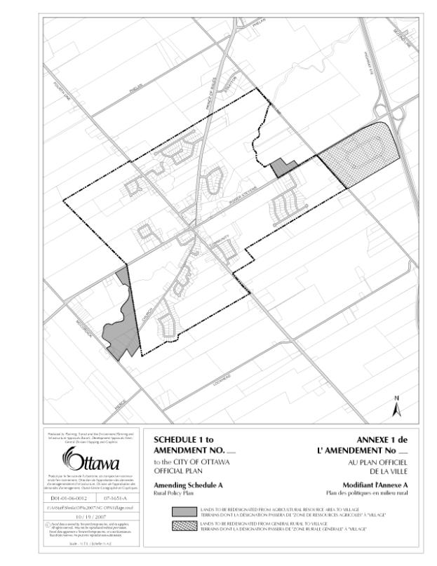
The Official Plan Amendment ___ also shows a revision to Schedule A – Rural Policy Plan to revise the existing North Gower village boundaries. It identifies three areas where staff recommend boundary expansions. The original proposal by the Design Group included residential areas located outside the village boundaries and a significant amount of development land. The purpose of this request was to i) include residents who already feel that they live in North Gower; ii) include agricultural lands, which at one point in time were to be included in the village; and iii) to incorporate additional sections of Stevens Creek for the future enjoyment of residents.
Village expansions are typically undertaken when there is a lack of development land. This is not the case in North Gower, where it is estimated that there is a 50-year supply based on existing trends. Staff reviewed the residents’ proposal and concluded that boundary expansions could only occur on the basis of the following questions: Have the lands already been approved for development? Is there an impact on the supply of agricultural lands? As a result, the three areas described below are proposed to be incorporated into the village and to be re-designated from their current Official Plan designations.
i) Lands east of Client Service Centre/Works Yard
These six lots are located to the east of the current village boundary and east of the City’s North Gower Client Service Centre and works yard, which are designated as “Agricultural Resource Area”. Three of the lots are occupied by houses and three are still vacant. It is recognized that these contiguous lots have been created as building lots and are zoned for development, except for one lot located in the midst of these lots. It is recommended that these lands be incorporated into the village and the land use be re-designated from “Agricultural Resource Area” to “Village”.
ii) Lands at intersection of Highway 416 and Roger Stevens Drive
A number of years ago, these lands to the east of the village were approved for an industrial subdivision. These lands are designated as “General Rural Area” and are located adjacent to current village boundaries at Third Line Road. More recently, lots have been created and zoned for estate residential development. Since these lands already have been approved for development, staff are recommending that all these lands be brought into the village, even though these lands were not part of the original Design Group proposal. It is recommended that these lands be re-designated from “General Rural Area” to “Village”.
iii) Lands between McCordick Road and west of existing village boundary
These lands are located to the east of the existing village boundaries in the vicinity of Stevens Creek. A significant portion of these lands are developed or are located in the flood plain. This area includes about 15 homes/lots located near the intersection of Church Street and McCordick Road. To the north of this area is farmland, some of which is located in the Stevens Creek flood plain. The proposed village boundary will follow Stevens Creek and existing lot lines. These lands will be brought into the village and re designated from “Agricultural Resource Area” to “Village”. Since a majority of lands in this area have been developed primarily for housing, approximately 4.7 hectares of development land will be brought into the village with this proposed expansion area.
RECOMMENDATION 3.–
Implement the North Gower CDP through the Draft Comprehensive Zoning By-law
Zoning changes are proposed to implement Schedule A – Land Use of the North Gower Community Design Plan through revisions to the Draft Comprehensive Zoning By-law. Once Official Plan Amendment __ is approved, staff will prepare an implementing by-law on the basis of Document 3 for passing by City Council.
CITY STRATEGIC DIRECTIONS
The North Gower CDP will implement the City’s Strategic Plan by fulfilling the Planning and Growth Management Priority, Objective F5: Preserve Ottawa’s rural villages.
ENVIRONMENTAL
IMPLICATIONS
Staff worked closely with the Rideau Valley Conservation Authority in the preparation and review of the North Gower CDP due to the presence of Stevens Creek that winds through the village and its significant flood plain.
Rideau Valley Conservation Authority staff state they are “….pleased to see that the plan has incorporated a strong environmental component with emphasis on future development guided by a subwatershed planning approach”.
Staff was sensitive to the fact that North Gower is located in the rural area and is surrounded primarily by lands designated Agricultural Resource Area. Staff recommended village boundary expansions to minimize impact on the surrounding agricultural lands.
CONSULTATION
There were extensive public consultations throughout the planning process. In consultation with the Design Group, staff organized three public meetings to obtain feedback and comments on the presented materials. Flyers were delivered to all households and ads were placed in the local community newspaper. For the last two meetings, draft CDPs were available for pick-up at several locations in North Gower so that residents could review the document prior to the public meeting. In addition to these meetings, there have been numerous smaller meetings organized by staff with the Design Group to discuss specific topics, proposals or direction. These meetings were also open to interested individuals.
Comments
received and responses on the North Gower CDP (December 2006) and staff report
are summarized and provided in Document 4 - Consultation Details.
FINANCIAL IMPLICATIONS
N/A
SUPPORTING DOCUMENTATION
Document
1 North Gower Community Design Plan (On file with the City
Clerk’s Office)
Document 2 City of Ottawa Official Plan Amendment__
Document 3 Changes to Draft Comprehensive Zoning By-law
Document 4 Consultation Details
DISPOSITION
Planning, Transit and the Environment
Department to:
· Prepare a by-law adopting City of Ottawa Official Plan Amendment ___ and forward the by‑law to Legal Services Branch.
· Undertake statutory notification when Official Plan Amendment ___ has been adopted by City Council.
· Revise Annex 7 – Rural Village Plans to show a Community Design Plan for North Gower.
· Prepare implementing zoning by-laws and statutory notice after the Official Plan Amendment ___ has been approved..
Legal Services Branch to forward implementing
by-laws to City Council.
PROPOSED OFFICIAL PLAN AMENDMENT DOCUMENT 2
|
|

Official
Plan Amendment Modifications du Plan
directeur
To the City of Ottawa Official
Plan
Official
Plan Amendment ___ to the City of Ottawa Official Plan
INDEX
The Statement of Components
Part A – The Preamble
Purpose
Location
Basis
Part B – The Amendment
Introduction
Details of the Amendment
Implementation and Interpretation
Schedule A
Part C – The Appendices
N/A
The Statement of Components
Part A – The Preamble, introduces the actual Amendment but does not constitute part of the Amendment No. ___ to the City of Ottawa Official Plan.
Part B – The Amendment, consisting of the following text and schedules constitutes the actual Amendment No. ___ to the City of Ottawa Official Plan.
Part C – The Appendices, does not form part of the Amendment but is provided to clarify the intent and supply background information related to the Amendment.
PART A – THE PREAMBLE
1.0 Purpose
The purpose of the Amendment is a) to remove the North Gower Village Plan from Volume 2C of the City of Ottawa Official Plan and b) to revise the village boundaries as shown on Schedule A of the Official Plan and re-designate the affected lands to “Village”.
2.0 Location
The Amendment affects all of the land within North Gower and adjacent expansion lands.
3.0 Basis
The North Gower Community Design Plan (CDP) replaces the policies for North Gower that were adopted by the former Rideau Township now found in the Official Plan. The Official Plan 2003 (Section 2.5.6) indicates that community design plans will be the backbone of any significant change in a community and are intended to translate the principles and policies of the Official Plan at a local level.
Remove North Gower Village Plan
Secondary plans that existed prior to municipal amalgamation are included in Volume 2 of the Official Plan. Currently the policies for the village of North Gower are included in the village plan for Burritt’s Rapids, Kars, and North Gower found in Volume 2C. This Official Plan Amendment will delete reference to North Gower in Volume 2C as the policies will be superseded by the North Gower CDP.
The North Gower CDP was prepared on the basis of a collaborative planning process with residents, where City staff worked to develop a plan that includes a variety of means to implement the community vision. It also provides direction and details on how to achieve the residents’ vision, and includes direction on day-to-day matters such as zoning, subdivisions, parks and pathway planning and enhancement of the village core.
Revise village boundaries and redesignate to
“Village”
Expansion of the village boundaries was another result of input into the public consultation process. The Design Group, a group of residents who worked with staff during the planning process, identified lands that they felt should be brought into the village. These lands included:
- lands east of Client Service Centre/Works Yard over to Third Line Road,
- lands at intersection of Highway 416 and Roger Stevens Drive,
- lands between McCordick Road and west of village boundary, and
- the triangular piece of land bound by Third Line Road and Prince of Wales Drive (Stratton subdivision and lands to the south of this development) located north of village boundaries.
There was a strong desire to expand the village boundaries to i) include residents currently living outside the boundaries since they already feel that they live in North Gower; ii) include lands which at one time in the past were proposed to be included within the village boundaries, and iii) incorporate additional sections of Stevens Creek for the future enjoyment of residents.
Staff reviewed the request in light of Official Plan policies with respect to the relevant land use designations and the 2005 Provincial Policy Statement. Staff concluded that only limited village expansions could be supported. Several criteria were used in reviewing these resident proposed expansions. Are the lands approved for development? Will there be an impact on the supply of agricultural lands?
The following is the result of staff’s review of the lands proposed to be included the village expansion:
1. Lands east of Client Service Centre/Works
Yard
There are six lots are located to the east of the current village boundary and east of the City’s North Gower Client Service Centre and works yard, which are designated as “Agricultural Resource Area”. Three of the lots are occupied by houses and three are still vacant. It is recognized that these contiguous lots have been created as building lots and are zoned for development, except for one lot located in the midst of these lots. It is recommended that these lands be incorporated into the village and the land use be re-designated from “Agricultural Resource Area” to “Village”.
It is understood that at one time, lands located between this area, the village boundary and Third Line Road were contemplated to be part of the village. However, due to concerns from a property owner, this was not actually accomplished. It is understood that such concerns no longer exist. All this land is now farmed, contiguous and designated as “Agricultural Resource Area” in the Official Plan. Bringing this land into the village would add to an already very healthy supply of development land in the village. Therefore, staff have recommended that only the lots fronting Roger Stevens Drive, located to the east of the North Gower Client Service Centre, be included in the village expansion.
2. Lands
at intersection of Highway 416 and Roger Stevens Drive
A number of years ago, these lands to the east of the village were approved for an industrial subdivision. These lands are designated as “General Rural Area” and are located adjacent to current village boundaries at Third Line Road. More recently, lots have been created and zoned for estate residential development. Since these lands have already been approved for development, staff have recommended that all these lands be brought into the village, even though these lands were not part of the original Design Group proposal. It is recommended that these lands be re-designated from “General Rural Area” to “Village”.
3. Lands between McCordick Road and west of existing village boundary
Staff reviewed the possibility of bringing lands located south of Roger Stevens Drive, east of McCordick Road, and west of the existing boundary into the village. A number of residential lots front Church Street and McCordick Road, while there is a fairly contiguous area that is farmed located at the south-east quadrant of Roger Stevens Drive and McCordick Road, north of Stevens Creek. These lands north of Stevens Creek are recommended to remain outside the village boundary. It is proposed that only a portion of these lands consisting of residential lots, farmland and floodplain located to the south of Stevens Creek, a natural and identifiable boundary, be brought into the village. It is estimated that about 4.7 ha (about 11 acres) of development land (farmland) will be brought into the village.
4. Stratton subdivision and farmland to the
south
For the most part, these lands bounded by Prince of Wales Drive and Third Line Road are already developed as a residential community. These lands are designated as “General Rural Area” since it is recognized that these lands have less agricultural potential than the majority of lands surrounding North Gower, which are designated “Agricultural Resource”.
Staff originally proposed that all of these lands be brought into the village. However, as a result of negative comments received from many Stratton Drive residents, staff has not included these lands to be part of the village boundary expansion. As a consequence, the farmland located to the south of the Stratton subdivision will not be included in the village expansion.
PART B – THE AMENDMENT
All of this part of this document entitled Part B – The Amendment consisting of the following text and attached Schedule 1 constitutes Amendment No. __ to the City of Ottawa Official Plan.
2.0 Details of Amendment
The following
changes are hereby made to the City of Ottawa Official Plan:
2. 1 The following changes are hereby made to Volume 2C – Village Plans dealing with Burritt’s Rapids, Kars and North Gower:
i) Revise Table of Contents heading reference that currently states “Burrit’s Rapids, Kars, North Gower” to read “Burritt’s Rapids, Kars” and revise all subsequent references to only read “Burritt’s Rapids, Kars”
ii) Revise Table of Contents so that “3.7 Village Development (Kars and North Gower)” reads “Village Development (Kars)”
iii) Delete from Table of Contents the following text: “Section 3.7.3 Village of North Gower”
iv) Revise title of section that currently reads: “3.7 Village Development (Kars and North Gower)” to “3.7 Village Development (Kars)”
v) Reword first line of the document to remove “and North Gower” so that it reads “Policies for the Village of Kars”.
vi) Revise section 3.7.1.1 which currently reads “The existing boundaries of the Villages of Manotick, North Gower, and Kars are shown on Ottawa Official Plan Schedule A.” to read “The existing boundaries of the Villages of Manotick and Kars are shown on Ottawa Official Plan Schedule A.”
vii) Revise section 3.7.1.7 which states “The rates of growth in the Villages of Manotick, North Gower and Kars…” to read “The rates of growth in the Villages of Manotick and Kars…”
viii)Remove in its entirety section 3.7.3 Village of North Gower,;
ix) Delete entire section 5.11.4 Special Policy Areas.
x) Delete the text in section 5.13.4.1 that reads “along Ottawa Road No. 5 in the Village of North Gower and” so that the sentence reads “The lands designated C-1 indicate existing General Commercial development located along Ottawa Road No. 13 in the Village of Kars.”
iv) Remove Map 3 Schedule A LAND USE PLAN Village of North Gower so that only Map 4 Schedule A remains.
2.2 Amend Schedule A – Rural Policy Plan in the City of Ottawa Official Plan to re- designate lands from “Agricultural Resource Area” and “General Rural Area” to “Village” as shown on Schedule 1 of City of Ottawa Official Plan Amendment __.
3.0 Implementation and Interpretation
Implementation and interpretation of this Amendment shall be in accordance with the policies of the City of Ottawa Official Plan (2003).
CHANGES TO DRAFT COMPREHENSIVE ZONING BY-LAW DOCUMENT 3
North
Gower Zoning
|
|
|
Table 1
Draft
Comprehensive Zoning By-law
Existing
Zone Description
|
|
DR1 (Village Reserve Zone) Permitted uses
Include agricultural use, community garden, environmental preserve and education area and one detached dwelling. Regulations
No minimum lot area or minimum lot width requirements. |
|
O1 (Parks and Open Space Zone) Include
community garden, environmental preserve and education area, flood or erosion
control works, and park. Regulations
Include
no minimum lot width and no minimum lot area. |
RI (Rural Institutional
Zone)
Regulations
Minimum
lot area of 2000 sq.m. and minimum lot width of 30 m. in addition to other provisions. The maximum height limit of the principal
building is 10 m. |
RI1Same as
RI zone. Minimum
lot area (1000 sq.m.), minimum lot width (30 m.) in addition to other
provisions. The maximum height limit
of the principal building is 10 m. |
RI2Same as
RI zone. Minimum
lot area (1000 sq.m.), minimum lot width (60 m.) in addition to other
provisions. The maximum building
height of principal building is 12 m. |
RR (Rural Residential Zone) |
RR3 (Rural Residential Zone)See RR
description. Minimum
lot area is 8000 sq.m. and minimum lot width is 60 m. in addition to other
provisions. |
RR4 (Rural Residential Zone)Permitted uses
See RR
description. Regulations
Minimum
lot area is 4000 sq.m. and minimum lot width is 30 m., in addition to other
provisions. |
RU (Rural Countryside Zone)Permitted uses
Include
agricultural use, animal care establishment, animal hospital, equestrian
establishment, forestry operation and intensive livestock farm operation. There are
different requirements depending on the use. |
|
V2C (Village Residential Second Density Zone) Include bed and breakfast, detached dwelling, duplex
dwelling, home-based business, park and semi-detached dwelling. The V2C zone identifies specific regulations for minimum lot area, minimum lot width and other provisions. |
|
V2C [12r] |
|
V2C [16r] |
|
V2C [578r] |
|
V2C [590r] |
|
V2C [591r] |
|
V2C [606r] |
|
VM [161r] Permitted uses
See VM
description. |
|
VM1
(Village Mixed-Use Zone) Permitted uses
Include
bank machine, community health and social services centre, convenience store,
retail food store, and service and repair shop subject to conditions that
include being limited to less than 200 sq.m. leasable area. Permitted
residential uses including converted dwelling, detached dwelling unit,
retirement home, converted are permitted with conditions related to number of
residents in a group home or a retirement home – converted and maximum number of dwelling units in a
converted dwelling. Regulations
Minimum
lot area is 1,350 sq.m. and minimum lot width is 20 m. The maximum height limit is 8 m. (2 - 3
storeys). |
|
VM3
(Village Mixed-Use Zone) Permitted uses
See VM
description |
North Gower Zoning
Draft City of
Ottawa Comprehensive Zoning By-law |
|
|
Table 2
Proposed
zones to be used in North Gower
|
|
|
|
O1 subzone1 (Open Space and Leisure Zone) The
following use is also permitted: |
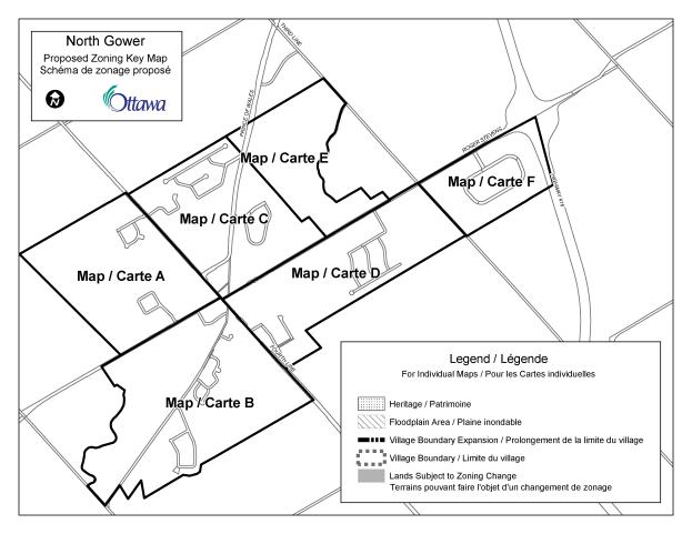
TABLE 3 Recommended Zoning
Details |
|
||
|
Ref. |
Draft City of Ottawa Comprehensive Zoning By-law |
Zoning recommendations |
|
|
|
|
|
|
|
|
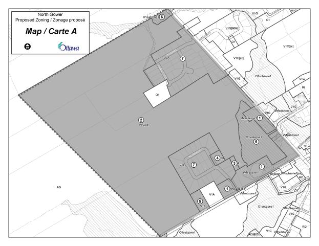
MAP A |
|
|
|
1 |
Along Roger Stevens Drive and Fourth Line Road and Fourth Line properties north of access to Union Cemetery Existing zone
VM (Village Mixed-use), DR1
(Village Reserve), V2C (Village Residential Second Density), V2C [578r]
(Village Residential Second Density), RC (Rural Commercial)
· See Table 1 for descriptions
|
Proposed zone
VM subzone1
· See Table 2 for description
|
|
|
2 |
Developable farmland
Existing zone
DR1
(Village Reserve) · See Table 1 |
Proposed zone
V1C [ex] · See
Table 2 |
|
|
3 |
Union Cemetery
Existing zone
DR1
(Village Reserve) ·
See Table 1
|
Proposed zone
RI (Rural
Institutional) · See Table 1 |
|
|
4 |
Craighurst Drive Park
Existing zone
V2C
(Village Residential Second Density) ·
See
Table 1
|
Proposed zone
O1 (Parks and Open Space) · See Table 1 |
|
|
5 |
(unaddressed)
Roger Stevens Drive
Existing zone
DR1
(Village Reserve) · See Table 1 |
Proposed zone
V1B
(Village Residential First Density) ·
See
Table 1
|
|
|
6 |
Portion of Stevens
Creek flood plain
Existing zone
DR1
(Village Reserve) · See Table 1 |
Proposed zone
O1
subzone1 ·
See
Table 2
|
|
|
7 |
Shellstar
and Craighurst subdivisions
Existing zone
V2C
(Village Residential Second Density) ·
See
Table 1
|
Proposed zone
V1G
(Village Residential First Density) ·
See
Table 1
|
|
|
|
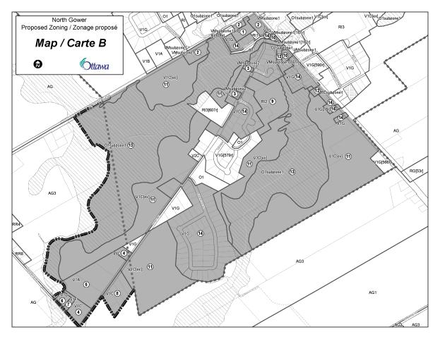
MAP B |
|
|
|
1 |
2338 Roger Stevens Drive (Perkins Lumber) Existing zone
VM3
(Village Mixed-Use) · See Table 1 |
Proposed zone
VM
subzone1 [ex] · See Table 2 |
|
|
2 |
2342 and 2346 Roger Stevens Drive 2392, 2384, 2364 Roger Stevens Drive (includes Stevens Creek Country Market) and 6606 Fourth Line Road 6608,
6610 Fourth Line Road, 2331 and 2332 Church Street Existing zone
V2C (Village Residential Second Density), DR1 (Village Reserve) and V2C [591r] (Village Residential Second Density), VM (Village Mixed-Use) · See Table 1 |
Proposed zone
VM
subzone1 · See Table 2 |
|
|
3 |
2361
Church Street and 2383 Church Street (H.O. Wright and Sons)
Existing zone
VM1 (Village
Mixed-Use) · See Table 1 |
Proposed zone
VM subzone2 · See Table 2 |
|
|
4 |
2535,
2589, 2595 Church Street
Existing zone
RR4
(Rural Residential) and AG3 (Agriculture) · See Table 1 |
Proposed zone
V1C (Village Residential First Density) · See Table 1 |
|
|
5 |
2549, 2571, 2577 Church Street Existing zone
AG3 (Agriculture) ·
See
Table 1
|
Proposed zone
V1A
(Village Residential First Density) ·
See
Table 1
|
|
|
6 |
6725
McCordick Road
Existing zone
RR4
(Rural Residential) · See Table 1 |
Proposed zone
V1D
(Village Residential First Density) ·
See Table 1
|
|
|
7 |
6731
McCordick Road
Existing zone
RR4 (Rural Residential) ·
See
Table 1
|
Proposed zone
V1F
(Village Residential First Density ·
See
Table 1
|
|
|
8 |
2550,
2556, 2562, 2578 Church Street Existing zone
RR4
(Rural Residential) ·
See
Table 1
|
Proposed zone
V1C
(Village Residential First Density) ·
See
Table 1
|
|
|
9 |
2368
Church Street (Holy Trinity Anglican Church)
Existing zones
·
See
Table 1
|
Proposed zone
RI2 ·
See
Table 1
|
|
|
10 |
6624
Fourth Line Road
Existing zone
VM [161r]
(Village Mixed-Use) and DR1 ·
See
Table 1
|
Proposed zone
VM
subzone1 [161r] and VM subzone1 ·
See
Table 2
|
|
|
11 |
Developable farmland
Existing zone
AG3
(Agriculture), DR1 (Village Reserve) · See Table 1. |
Proposed zone
V1C [ex] ·
See Table 2
|
|
|
12 |
6680
Fourth Line Road Existing zone
RC (Rural
Commercial) ·
See Table 1.
|
Proposed zone
RC
subzone1 ·
See
Table 2.
|
|
|
13 |
Portion
of Stevens Creek flood plain
Existing zone
DR1
(Village Reserve) ·
See
Table 1
|
Proposed zone
O1
subzone1 · See Table 2 |
|
|
14 |
Existing zone
V2C (Village Residential Second
Density) and DR1 (Village Reserve)
·
See
Table 1
|
Proposed zone
V1G · See Table 1 |
|
|
15 |
6696
Fourth Line Road
Existing zone
V2C [16r] ·
See
Table 1
|
Proposed zone
V1G [16r] ·
Retain
exception
|
|
|
|
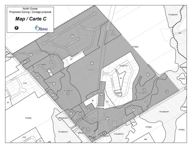
MAP C
|
|
|
|
1 |
Existing zone
DR1
(Village Reserve), V2C (Village Residential Second Density) ·
See
Table 1
|
Proposed zone
V1C [ex] ·
See
Table 2
|
|
|
2 |
6575,
6577, 6579, 6581, 6583, and 6587 Fourth Line Road, 2311 2317, and 2321 Andrew
Street (east side Fourth Line Road and north of Andrew Street) 6595,
6599, 6601, 6603 Fourth Line Road, 2307, 2311, 2313, 2321 and 2323 Roger
Stevens Drive Existing zone
V2C
(Village Residential Second Density), VM (Village Mixed-Use), VM1 (Village
Mixed-Use), RC (Rural Commercial) ·
See
Table 1
|
Proposed zone
VM subzone1 ·
See
Table 2
|
|
|
3 |
Existing zone
V2C[606r] ·
See
Table 1
|
Proposed zone
V1G
[606r] ·
See
Table 1 for V1G
·
Retain exception
|
|
|
4 |
Existing zone
V2C [12r] ·
See
Table 1
|
Proposed zone
V1C [12r] ·
See
Table 1 for V1C
·
Retain
exception
|
|
|
5 |
6563
Fourth Line Road (Shipman Surveying)
Existing zone
V2C
[587r], DR1 ·
See
Table 1
|
Proposed zone
VM
subzone1 ·
See
Table 2
|
|
|
6 |
2307
Roger Stevens Drive (Old Co-op)
Existing zone
RC ·
See
Table 1
|
Proposed zone
VM subzone1 ·
See
Table 2
|
|
|
7 |
Existing zone
DR1
(Village Reserve), V2C (Village Residential Second Density) ·
See
Table 1
|
Proposed zone
V1G ·
See
Table 1
|
|
|
8 |
Portion
of Stevens Creek flood plain
Existing zone
DR1
(Village Reserve) ·
See
Table 1
|
·
See
Table 2
|
|
|
|
|
|
|
|
|
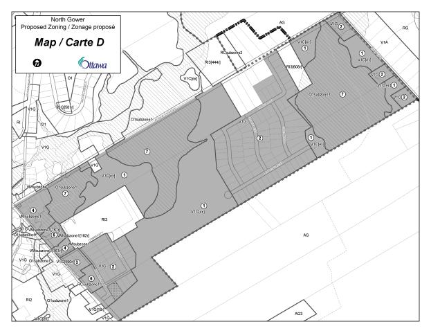
MAP D
|
|
|
|
1 |
Existing zone
DR1
(Village Reserve) ·
See
Table 1
|
Proposed zone
V1C [ex] ·
See Table 2
|
|
|
2 |
Existing zone
V2C
(Village Residential Second Density), DR1 (Village Reserve) ·
See
Table 1
|
Proposed zone
V1G ·
See
Table 1
|
|
|
3 |
Existing zone
V2C
[590r] ·
See
Table 1
|
Proposed zone
V1G
[590r] ·
See
Table 1
·
Retain
provisions of exception
|
|
|
4 |
2310,
2314, 2316, 2320, 2322 Roger Stevens Drive 6607, 6609, 6613, 6615, 6617,
6619, 6623, 6627, 6631, 6649 Fourth Line Road, 2319 Community Way Existing zones
V2C
(Village Residential Second Density), RI1 (Rural Institutional), VM (Village
Mixed-Use), DR1 (Village Reserve) ·
See
Table 1
|
Proposed zone
VM
subzone1 ·
See
Table 2
|
|
|
5 |
6635,
and 6645 Fourth Line Road Existing zone
VM [162r]
(Village Mixed-Use) ·
See
Table 1
|
Proposed zone
VM
subzone1 [162r] ·
See
Table 2
|
|
|
6 |
6679
and 6683 Fourth Line Road Existing zone
RC (Rural
Commercial) ·
See
Table 1
|
Proposed zone
RC
subzone1 ·
See
Table 2
|
|
|
7 |
Portion
of Stevens Creek flood plain Existing zone
DR1
(Village Reserve) ·
See
Table 1
|
Proposed zone
O1
subbzone1 ·
See
Table 2
|
|
|
|
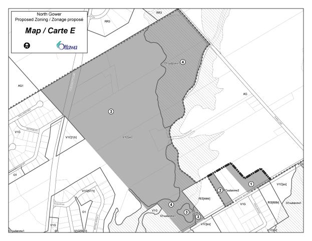
MAP E |
|
|
|
1 |
2115
Roger Stevens Drive
Existing zone
DR1
(Village Reserve), V2C (Village Residential Second Density) ·
See
Table 1
|
Proposed zone
V1G ·
See
Table 1
|
|
|
2 |
2137
Roger Stevens Drive
Existing zone
RC [167r]
(Rural Commercial) ·
See
Table 1
·
Exception
[167r] permits office and recreational and athletic facility
|
Proposed zone
RC
subzone2 ·
See
Table 2
|
|
|
3 |
Existing zone
DR1 (Village
Reserve Zone) ·
See
Table 1
|
Proposed zone
V1C [ex] ·
See
Table 2
|
|
|
4 |
Portion Stevens Creek
Flood plain
Existing zone
DR1
(Village Reserve) ·
See
Table 1
|
Proposed zone
O1
subzone1 ·
See Table
2
|
|
|
|
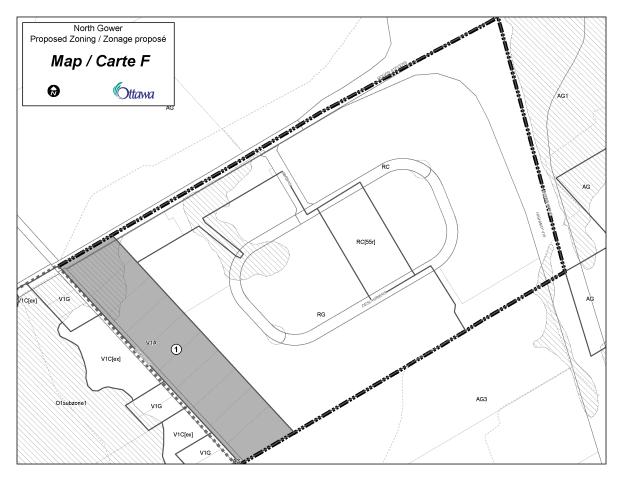
MAP F |
|
|
|
1 |
Existing zone
RR3
(Rural Residential) ·
See
Table 1
|
Proposed zone
V1A ·
See
Table 1
|
|
CONSULTATION DETAILS DOCUMENT
4
The following table summarizes comments and
Departmental responses to them as a result of the consultation undertaken on
the revised draft of the North Gower Community Design Plan (December
2006). This revised draft was presented
at a public meeting/open house in January 2007 and the following summarize the
comments received.
In April 2007, a summary of the public comments
and draft departmental response was sent to residents on the CDP mailing
list. Afterwards further comments were
received from a few individuals with additional comments requesting further
changes. The table below summarizes
comments received.
North
Gower Community Design Plan (December 2006)
Comments
|
|||
|
Ref. # |
Topic
|
Comments
|
Departmental
Response
|
|
|
|
|
|
Councillor’s
Comments
|
|||
|
|
|
|
|
Community
Organization Comments
|
|||
|
|
|
§ The North Gower Design Group have actively participated in the preparation of the North Gower CDP and are aware of the staff recommendations. |
|
Advisory
Committee Comments
|
|||
|
|
|
§ Staff have made a presentation at the Rural Issues Advisory Committee (RIAC) on August 15, 2006 and was requested to report back with respect to resolution of issues. On June 19, 2007 staff and the chairperson of the Design Group updated RIAC indicating that much had been accomplished and no outstanding issues remained. |
|
Pathways and Parks
|
|||
|
Andrew St. |
§
Resident was very anxious and concerned about the
future of her property and requested that pathway crossing their property be
removed from multi-use pathway plan. |
§ The proposed pathway on resident’s land shown on Schedule C – Multi-Use Pathway Plan will be removed. Further text will be added under Implementation in Section 4.3 Multi-Use Pathway Plan, which will indicate that the City will seek opportunities to complete the pathways, in consultation with landowners at the time of any development applications. In certain situations, existing or proposed sidewalks may complete pathway links. |
|
|
Andrew St. |
§ This resident reiterated her parents concerns about a proposed conceptual pathway on their property. § She indicated that her parents were uninformed about nature of pathway and conveyed the anxiety caused in their lives. |
§ See response to #1. |
|
|
3 |
Roger Stevens Drive |
§ This resident does not support multi-use pathway on his property |
§ See response to #1. |
|
|
§ It is up to the City to ensure developers include sufficient green space for recreation and leisure within the boundaries of new development. |
§ A comprehensive review was undertaken of the existing park and open space system. This resulted in proposed locations of future parks that would optimize the use of existing park spaces and open spaces (floodplains). § Developers are required to provide land or cash to support this system. The Planning Act permits the taking of parkland (5% for residential subdivisions or 2% for non-residential subdivisions) during the subdivision application process. The Official Plan expresses City Council’s intent regarding the acquisition of parkland, however, specific details on how this will be implemented is required. Staff work is underway. § See response to #9 Neighbourhood parks. |
|||
|
4 |
Fourth Line Road |
§ Proposed multi-use pathway from Edward Kidd Parkette to Prince of Wales Drive runs through backyard and is too close to creek and creates a hazard. § Pathway should be moved to north side of creek. Understands that pathway is conceptual and landowner approval is required before it is built. |
§ See response to #1. |
|
|
5 |
Fourth Line Road |
§ Does not have a problem with proposed pathway, but strongly opposes decision to have it cross over his property. § Privacy would be lost with people crossing over property and possible litter. § Perhaps proposed sidewalk in front of property could be used. |
§ See response to #1 |
|
|
6 |
Roger Stevens Drive |
§ Proposed pathway is shown running across property on the bank of Stevens Creek and would like it removed from the plan. |
§ See response to #1 |
|
|
7 |
James Craig Street |
§ Would like proposed pathway removed from his property. |
§ See response to #1 |
|
|
Fourth Line |
§ Owners of 6563 Fourth Line are vehemently opposed to proposed conceptual pathway on their property. Requests that a conceptual multi-use pathway not be shown through rear yard due to privacy issues. They also are against a pathway on the undeveloped portion of their lands. |
§ See response to #1 |
||
|
§ Due to site conditions the proposed conceptual pathway crossing 6449 Fourth Line Road, which is bisected by the Taylor Drain, would have a pathway running through a portion of the front yard and rear yard of the house. Relocating the proposed pathway to the other side of the creek would bring it in proximity to the workshop and machine shed. |
See response to #1. |
|||
|
§ Concerned about the possible “Future Commercial” located on Schedule A – Land Use. |
§ This designation is conceptual and a rezoning will be required. Any rezoning would require a public process. |
|||
|
9 |
|
Neighbourhood parks
§ “Neighbourhood parks should not be located in the flood plain. If the intention is to develop a parkette then it should not be in the flood plain…. If there are other local parks nearby… and the intention is to provide a more passive area adjacent to the Creek, then fine….the City should negotiate 10% as opposed to 5%…. “Any public land that is owned along Stevens Creek should be purchased using the Cash-in-Lieu of Parkland reserve funds…. Funds which have been accumulated from the rural severances” |
§ New neighbourhood parks have not been proposed in the flood plain. In one instance, a new park is proposed adjacent to a flood plain to take advantage of the open space. § See #3 Green space for response. |
|
Alfred Taylor Recreation Facility§ 4.8 Implementation should have a “1b) Acquire additional land adjacent to the Alfred Taylor Recreation Facilities.” |
§ Acquisition of additional land may be an outcome of the staff proposed review of the Alfred Taylor Recreation Facility master plan. Until a review of community needs has been undertaken, discussion of land acquisition adjacent to the Alfred Taylor Recreation Facility is premature. |
|||
|
§ Item 5 should be reworded. The cash-in-lieu of parkland was originally intended to fund new items. The purpose was to acquire larger parcels of property rather than take 5% of a 2-acre severance. The philosophy has been to use the fund to purchase land or “new” capital items and not to fund maintenance or “improvements”. |
§ See response to #1 Neighbourhood parks. |
|||
|
§ Appendix 3 – add bowling alley to the list of parks and add name to park. |
§ According to Parks and Recreation staff, if the community wishes to designate this site as a park, then there must be support from the community association and ward councillor who would in turn present a motion at a Community and Protective Services Committee for Council approval. Alternatively this proposal may be included in the plan as part of the CDP approval process. |
|||