|
1. ZONING - 1160, 1170 AND
1172 WALKLEY ROAD
ZONAGE - 1160, 1170 ET
1172, CHEMIN WALKLEY
|
Committee recommendationS as
amended
(This application is subject to Bill 51)
That Council:
1. Approve an amendment
to the former City of Ottawa Zoning By-law to include new exception provisions
for the CG [879] F(1.22) F(1.3) H(35.0) zone applicable to 1170 and
1172, and part of 1160 Walkley Road as shown on Document 1 and as detailed in
Document 2.
2. Approve an amendment
to the New Comprehensive Zoning By-law to include new exception provisions for
the GM1[1404] F[1.22) H(35) zone, applicable to 1160, 1170 and 1172 Walkley
Road as shown on Document 1 and as detailed in Document 2.
RecommandationS modifiÉeS du Comité
(Cette demande est assujettie au
Règlement 51)
Que le Conseil :
1. approuve une modification au Règlement
de zonage de l’ancienne Ville d’Ottawa ayant pour but d’ajouter des exceptions
à la désignation de zonage CG [879] F(1.22) F(1.3) H(35.0) s’appliquant
aux 1170 et 1172 ainsi qu’à une partie du 1160, chemin Walkley, propriétés qui
sont illustrées dans le document 1 et précisées dans le document 2.
2. approuve une modification au nouveau
Règlement de zonage général de la Ville d’Ottawa ayant pour but d’ajouter des
exceptions à la désignation de zonage GM1[1404] F[1.22) H(35) s’appliquant aux
1160, 1170 et 1172, chemin Walkley, propriétés qui sont illustrées dans le
document 1 et précisées dans le document 2.
For the information of
council
The Planning and Environment Committee
approved the following direction to staff:
That Staff be directed upon site plan approval for this development, that the location of the sidewalk be adjacent to the proposed building at the lot line; and the corresponding required landscaping be adjacent to the Walkley roadway.
Pour la gouverne du Conseil
Le Comité de l’urbanisme et de l’environnement a approuvé la directive suivante :
Que l’on prescrive au personnel sur
approbation du plan d’implantation pour cet aménagement, que le trottoir soit
adjacent au bâtiment proposé à la ligne de lot et que l’aménagement paysager
soit adjacent à la chaussée du chemin Walkley.
Documentation
1.
Deputy
City Manager's report Planning, Transit
and the Environment dated 30 May 2008 (ACS2008-PTE-PLA-0129).
2.
Extract
of Draft Minute, 10 June 2008.
Report to/Rapport au :
Planning and Environment Committee
Comité de l'urbanisme et de l'environnement
Submitted by/Soumis par : Nancy Schepers, Deputy City Manager
Directrice municipale adjointe,
Planning, Transit and the Environment
Urbanisme, Transport en commun et Environnement
Contact
Person/Personne Ressource : Grant Lindsay, Manager / Gestionnaire,
Development Approvals / Approbation des demandes d'aménagement
(613)
580-2424, 13242 Grant.Lindsay@ottawa.ca
|
SUBJECT: |
ZONING - 1160, 1170 and 1172 Walkley
Road (FILE NO. D02-02-08-0020) |
|
|
|
|
OBJET : |
REPORT RECOMMENDATIONS
1.
Approve an
amendment to the former City of Ottawa Zoning By-law to include new exception
provisions for the CG [879] F(1.3) H(35.0) zone applicable to 1170 and 1172,
and part of 1160 Walkley Road as shown on Document 1 and as detailed in Document 2.
2.
Approve an
amendment to the New Comprehensive Zoning By-law to include new exception
provisions for the GM1[1404] F[1.22) H(35) zone, applicable to 1160, 1170 and
1172 Walkley Road as shown on Document 1 and as detailed in Document 2.
RECOMMANDATION DU RAPPORT
Que le Comité de recommande au Conseil :
1. d’approuver
une modification au Règlement de zonage de l’ancienne Ville d’Ottawa ayant pour
but d’ajouter des exceptions à la désignation de zonage CG [879] F(1.3) H(35.0) s’appliquant
aux 1170 et 1172 ainsi qu’à une partie du 1160, chemin Walkley, propriétés qui
sont illustrées dans le document 1 et précisées dans le document 2.
2. d’approuver une
modification au nouveau Règlement de zonage général de la Ville d’Ottawa ayant
pour but d’ajouter des exceptions à la désignation de zonage
GM1[1404] F[1.22) H(35) s’appliquant aux 1160, 1170 et 1172, chemin
Walkley, propriétés qui sont illustrées dans le document 1 et précisées dans le
document 2.
BACKGROUND
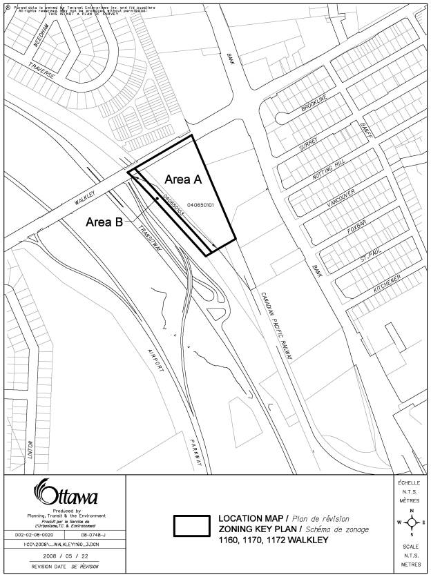
The subject property is located at 1160, 1170 and 1172 Walkley Road, on the south side of Walkley Road, just west of the southwest corner of Bank Street and Walkley Road, and includes part of the existing O‑Train line.
The privately owned segment of the subject property is approximately 1.98 hectares in area, is triangular in shape with frontage of approximately 124 metres and a depth of 234 metres. The property is currently undeveloped, with the exception of an unused internal road that was used in the past for access to the former Canadian Pacific Railway tracks adjacent immediately to the west. These tracks are now used by the O-Train. Part of the abutting O-Train corridor is included in this re-zoning. There are a number of trees and shrubs scattered throughout the property and an overhead pole line runs along the east side of the property. The property has a significant change in grade from Walkley Road, which rises in a westerly direction for the bridges over the railway line, the bus Transitway and the Airport Parkway, which are nearby to the west. There is a bus Transitway station at Walkley Road but currently no O-Train station at this location. The site drops down from north to south and from east to west. Across to the north backing onto Walkley Road is a townhouse development. To the east are the backs of commercial developments oriented to Bank Street.
Purpose of
Zoning Amendment
The purpose of the proposed zoning is to facilitate a hotel proposed for the site, which would include 191 residence hotel rooms, banquet rooms and related facilities. In addition, two restaurants are proposed in the foreground of the property, adjacent to Walkley Road. There is potential for additional future development on the southerly portion of the property.
The current zoning of the property under the former City of Ottawa Zoning By-law is CG[879]F(1.22)(H35.0). This is a General Commercial Zone, with an exception. The maximum floor space index is 1.22 and the maximum height is 35 metres. The CG zone permits a range of non-residential uses such as bank, office, recreational/athletic facility and retail store, as well as residential uses such as high-rise apartment building, detached house and townhouse. The exception is that section 343 of the by-law not apply; section 343 limits the useable FSI to 50 per cent of the stated 1.22 limit in the base CG zone.
The zoning under the City Council approved consolidated Zoning By-law is GM1[1404] F(1.22) H(35), General Mixed-Use Zone. This zone permits uses similar to those permitted in the CG[879]F(1.220)(H35.0) zone under the former City of Ottawa By-law. The height and floor space limits are also the same as those of the GM1 zone.
The proposed Zoning By-law amendment is to add a “hotel” as a permitted use, in both the former City of Ottawa By-law 93-98 and in the new City Council approved consolidated Zoning By‑law. The amendment also proposes to reduce the required front yard from 6.0 metres to 0.0 metres in the CG zone and from 3.0 metres to 0.0 metres in the GM1 zone, and to allow the property to be considered as “one‑lot” for by-law conformity purposes in both by-laws. The rezoning recommended by staff also includes an increase in FSI in both bylaws from 1.22 to 1.3.
DISCUSSION
The subject property is located within the
General Urban Area designation of the Official Plan (OP) and is adjacent to
lands to the east fronting on Bank Street, that are designated Arterial Main
Street. Lands immediately to the west
are designated as an Urban Natural Feature, (Mid‑Sawmill Creek Corridor)
and on the west side of the Airport Parkway corridor is Major Open Space. The OP designates Walkley Road as an
Arterial Road, and routes designated for both Rail (current O-Train) and Bus Rapid
Transit (current South-east Transitway) are adjacent to the west.
The provisions of Section 2, Strategic
Directions of the OP call for support of intensification in all urban areas
including the General Urban Area. These provisions will promote opportunities
for compact urban form and intensification on lands within 600 metres of rapid
transit stations with the potential to develop as compact mixed use and
pedestrian friendly cores. The
Strategic Directions also indicates that the City will consider increases in density
when a proposal involves a development of a transit station. The proposed rezoning adds hotel use to the
list of permitted uses, and will help stimulate development intensification on
the property immediately adjacent to an existing and proposed transit
facility. A development such as a hotel
use will facilitate more efficient use of the existing “Walkley” bus rapid
transit station and provide an opportunity for effective integration with any
future light rail transit (LRT) station, if one is constructed along the
adjacent rail corridor. As well,
Walkley Road has been identified as a potential route to accommodate an
east-west LRT transit service, which would also serve the proposed development.
The policies of Section 3.2.3. for the General
Urban Area designation support development of employment, retail and services
uses as well as a full range or residential uses. The policies also indicate that uses that may have an impact on a
surrounding community should be located at the perimeter of neighbourhoods and
in proximity to arterial roads or rapid transit routes.
The addition of the hotel use, which will help
provide employment through a service use at a location separated from
residential areas by an arterial road and adjacent to rapid transit, is
consistent with the intent of the General Urban Area policies.
The policies of Section 4.3. Walking, Cycling,
Transit, Roads and Parking Lots promote increased use of transit by advocating
that development within 600 metres of a transit station or stop, provides for
direct access and integration to stations, locates higher densities and
employment close to transit stations, and minimizes walking distances to
transit. The development anticipated
with the addition of the hotel use will be conducive to a direct convenient
relationship with existing and potential adjacent transit facilities, including
possible direct integration with any future adjacent LRT station. The addition of the hotel use will also help
to stimulate other permitted uses on the property in the future, which could
further satisfy the transit oriented development objectives. The policies of Section 4.3 also outline the
need to evaluate the potential impact of traffic from a development on the surrounding
roadway system. The Traffic Impact
Study provided in relation to the proposed development, has been reviewed by
City staff and potential impact generated by the proposed hotel use, is
considered to be minimal.
Section 4.11 of the OP establishes policies for development compatibility. The proposed re-zoning is not anticipated to generate any compatibility concerns, which, being more directly related to physical design, will be more thoroughly evaluated through the Site Plan Control approval process. Compatibility factors related to traffic and vehicular access have been reviewed and, given the location along an arterial road, Walkley Road with a signalized intersection available for site access, the proposal is not anticipated to cause any compatibility problems associated with development stemming from the re-zoning.
Schedule D of the Official Plan indicates a future east-west “rapid transit corridor - alignment to be defined” which would bypass the downtown. The City started the Environmental Assessment (EA) process for this East-West Corridor LRT Project and advanced to the stage of identifying a preferred route, which in this area would be running east-west along Walkley Road. Preliminary design drawings were prepared that show, for the segment of road at 1160 Walkley Road, the need for an approximately 41-metre wide right-of-way to accommodate LRT, vehicular traffic, cycling and sidewalk needs. Council has put this section of the LRT on hold until after the up-dated Transportation Master Plan confirms the need for this corridor. The implication for the development of this property is that a strip of property of about seven metres in width along the front of the property may be needed by the City.
The proposed Zoning By-law
amendment contains a provision to permit a zero set-back for buildings along
Walkley Road. The OP Design Objectives
of Section 2.5.1 support the concept of developing continuous building facades
along major streets through gradual infilling over time in order to make
streets more vibrant and pedestrian-friendly.
Allowing for a zero front yard set back is in keeping with this
objective. While the front yard
zone setback is proposed to be reduced to zero, at the site plan approval stage
for this development provision could be made to ensure that buildings are
setback an adequate distance from the existing property line so that a widening
is feasible to address potential LRT needs and the reduced setback would apply
after any appropriate widening based on the new property line.
The proposed Zoning By-law amendment will establish provisions to allow the applicant’s lands, should they be divided in the future, and potentially the area of the adjacent O-Train corridor, to be considered as one property for zoning compliance purposes. The “one-lot” provision will facilitate more efficient use and design of the lands involved, by permitting potential sharing of facilities, such as parking and access roads, and thus help to ensure that this important location can fully realize the development potential desired in association with the abutting rapid transit facilities. The one lot provision does ensure that all minimum requirements of the Zoning By-law are fulfilled across the area to which the provision applies.
The proposed Zoning By-law amendment has been evaluated in terms of the
intent of the Strategic Direction policies of the Official Plan and it is the
Department’s opinion that the application merits approval.
ENVIRONMENTAL IMPLICATIONS
The subject properties are adjacent to an Urban Natural Feature and therefore an Environmental Impact Statement (EIS) is required to allow development to proceed. The proposed Zoning By-law amendment will have no significant environmental impact on the adjacent area of environmental concern, the Sawmill Creek corridor, given that that it constitutes a minor change to existing commercial zoning. The EIS submitted pertaining to the related development proposal indicates that the proposal will not have significant impact on the adjacent “Urban Natural Area”, and is well separated from the Sawmill Creek and the riparian wooded areas by the Transitway and off-ramp from the Airport Parkway. The EIS provides mitigation recommendations that will be applied through the related Site Plan Control approval application as required.
CONSULTATION
Notice of this application was carried out in accordance with the City's Public Notification and Consultation Policy. The Ward Councillor is aware of this application and has indicated support for the staff recommendation for approval. Comments in favour and opposed to the application have been received from the public. A summary of comments and the staff responses are contained in Document 3.
FINANCIAL IMPLICATIONS
APPLICATION PROCESS
TIMELINE STATUS
This application was processed by the "On Time
Decision Date" established for the processing of Zoning By-law amendment
applications.
SUPPORTING DOCUMENTATION
Document 1 Location Map
Document 2 Details
of Recommended Zoning
Document 3 Consultation
Details
DISPOSITION
City Clerk’s Branch, Council and Committee
Services to notify the owner, 1686864 Ontario Inc., Manor Park Management, 231
Brittany Drive, Unit D, Ottawa, K1K 0R8, applicant, OttawaScene.com, 174 Colonnade Road, Unit #33, Ottawa, ON K2E 7J5,
Ghislain Lamarche, Program Manager, Assessment, Financial Services Branch (Mail
Code: 26-76) of City Council’s
decision.
Planning, Transit and the Environment
Department to prepare the implementing by-law, forward to Legal Services Branch
and undertake the statutory notification.
Legal Services Branch to forward the
implementing by-law to City Council.
LOCATION MAP DOCUMENT
1
DETAILS OF RECOMMENDED ZONING DOCUMENT
2
A. The lands shown on Document 1, Part
A, are to be rezoned in By-law 93-98 of the former City of Ottawa from CG[879]
F(1.22) H(35.0) to CG[879] F(1.3) H(35.0) to permit a hotel development subject
to the following:
1. The following exceptions shall apply:
a. Hotel is added as a permitted use;
b. The minimum front yard set-back is 0.0 metres;
c. The lands shown on Document 1, Part A, shall be considered as one lot for Zoning By‑law compliance purposes;
d. The provisions of Sections 56, 64 and 65 do not apply to any surface parking; located on the property.
2. The maximum floor space index is 1.3.
B. The lands shown on Document 1,
Parts A and B, are to be rezoned in the City Council Approved Zoning By-law
from GM1[1404] F(1.22) H(35) to GM1[1404] F(1.3) H(35) to permit a hotel
development subject to the following:
1. The following
exceptions shall apply:
a. Hotel is added as a permitted use;
b. The minimum front yard set-back is 0.0 metres;
c. The lands shown on Document 1, Parts A and B, shall be considered as one lot for zoning by-law compliance purposes;
d. The provisions of Sections 106(1), 106(3), 107(1)(a), 107(1)(c) and 107(2) do not apply to any surface parking; located on the property.
2. The maximum floor space index is 1.3.
CONSULTATION DETAILS REVISED
DOCUMENT 3
NOTIFICATION AND CONSULTATION PROCESS
Notification and public consultation
was undertaken in accordance with the Public Notification and Public
Consultation Policy approved by City Council for Zoning By-law amendments. Meetings were also held by Councillor McRae
with the developer and the local community associations.
PUBLIC COMMENTS
There were four responses from the general public regarding the proposed development; one opposed, one in favour, and two seeking information. A summary of the issues cited and the staff responses is as follows:
1. Comment: The proposal is fully supported and will likely raise our property values; will our taxes go up?
Response: There is no indication that the recommended re-zoning will impact the property values of the nearby residential development.
2. Comment: Just as there has been a problem with street lighting in our residential development across the street to the north, the Marriott development should be required to provide proper lighting for safety.
Response: Site lighting will be addressed through the related Site Plan approval for the proposed development on the property.
3. Comment: The requested re-zoning should not be approved; the area does not need the proposed facilities, which will greatly increase traffic and pollution in the area and not support or enhance the nearby residential community.
Response: The change in development potential associated with the recommended rezoning to add hotel to the list of permitted uses, and adjust a limited group of performance standards will have minimal impact on the potential for traffic and pollution generated from development of the property. The traffic study provided demonstrates that there will be minimal impact on the surrounding roadways from the proposed development; and the high potential for transit integration may result in reduced pollution levels as compared to other development situations.
COUNCILLOR’S COMMENTS
Councillor Maria McRae is aware of this application and also provided the following comment:
“I writing today on behalf of the Ridgemont Community Association (RCA) and the Riverside Park Community and Recreation Association (RPCRA) regarding the Site Plan Control application for 1160 Walkley Road.
I had the opportunity to meet with the RCA, the RPCRA and the developer on a number of occasions to discuss this application. I am pleased to note that both Community Associations look favourably upon this application. They believe this is a positive development proposal that will aid in beautifying the area.
At a meeting I hosted on Wednesday, March 26, 2008, both the RCA and the RPCRA expressed their concern regarding the possibility of having an access road to this property from Bank Street. An access road from Bank Street will increase the volume of traffic in the Ridgemont Community. This poses a grave concern with local residents.
The RCA and the RPCRA agree that any access to this site from Bank Street should be in the form of a pedestrian/bike path, or an emergency fire access route if required. I fully support the position of the RCA and the RPCRA in their request to not allow a through traffic access point to this site from Bank Street. I am pleased to note that the developer agreed to these restrictions at the March 26, 2008 meeting.
In light of the concerns shared by the RCA and RPCRA, I request that these restrictions be included in the site plan approval process.
I look forward to receiving your feedback on this request.”
Response to Comment
Access to the subject property will be addressed through the related Site Plan Control application. The related site plan proposal does not include direct access to Bank Street.
COMMUNITY ORGANIZATION COMMENTS
The Riverside Park Community and Recreation Association provided the following comment:
“Members of the Board of Directors of the Riverside Park Community and Recreation Association (RPCR A) have meet twice with the applicant and his representatives.
The Board of the RPCRA supports this development with the understanding that there will not be any access from or to the hotel on Bank Street. As well, the applicant is to minimize/eliminate the traffic from this project traveling through the Ridgemont Community.”
Response to Comment
Access to the subject property will be addressed through the related Site Plan Control application. The related site plan proposal does not include direct access to Bank Street.
The Ridgemont Community Association provided the following comment:
“Dear Councilor McRae:
After several meetings that the Ridgemont Community Associations' Board of
Directors had with you, representative of the Riverside Park Community and
Recreation Association and representatives for the applicant, our Board has
agreed with the application to build a hotel etc. on Walkley Road, west of Bank
St.
We brought forward conditions that were important to our community.
These conditions were agreed to by all and were to be implemented in the
finalization of the project.
To minimize/eliminate the traffic from this project traveling through our
community with no accesses onto Bank St. other than for emergency vehicles
and possibly pedestrians and/or cyclists.
Please contact me if further information is required.”
Response to Comment
Access to the subject property will be addressed through the
related Site Plan Control application.
The related site plan proposal does not include direct access to Bank
Street.