|
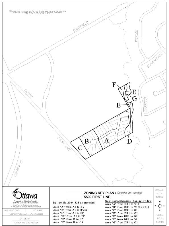
2. zoNING - 5599
First Line Road zonage - 5599, chemin first line |
Committee
Recommendations
(This application is not subject to Bill 51)
That Council:
1. Approve an amendment to the former Township of Rideau Zoning
By-law to change the zoning of 5599 First Line Road from "A1"
(Restricted Rural), "EP" (Environmental Protection) and "D"
(Development) to "RV-32 " (Village Residential Exception 32),
"RV" (Village Residential), "EP" (Environmetal Protection)
and "OS" (Open Space) as shown in Document 1 and detailed in Document
2.
2. Approve an amendment
to the new Comprehensive Zoning By-law to change the zoning of 5599 First Line
Road from (DR1) - (Development Reserve Zone) to (VIP [---r] - (Village
Residential First Density, Subzone P), (VIP) - Village Residential First
Density, Subzone P and (O1) - (Parks and Open Space), as shown in Document 1
and detailed in Document 2.
Recommandations
du comité
(Cette demande n’est pas
assujettie au projet de loi 51)
Que le Conseil :
1. Approuve
une modification au Règlement de zonage de l'ancien Canton de Rideau visant à
faire passer le zonage de la propriété située au 5599, chemin First Line de A1
(zone rurale d'aménagement restreint), EP (zone de protection de
l'environnement) et D (zone d'aménagement) à RV-32 (zone résidentielle de
village, exception 32), RV (zone résidentielle de village), EP (zone de
protection de l'environnement) et OS (zone d'espaces libres), comme l'illustre
le document 1 et le précise le document 2.
2. Approuve une modification au nouveau
Règlement de zonage général visant à faire passer le zonage de la propriété
située au 5599, chemin First Line de DR1 (zone d’aménagement différé) à VIP
[---r] (zone résidentielle de village de densité un, sous-zone P), V1P (zone
résidentielle de village de densité un, sous-zone P) et O1 (zone d'espaces
verts et de parcs), comme l’illustre le document 1 et le précise le document 2.
Documentation
1.
Deputy
City Manager's report (Planning, Transit and the Environment) dated
27 May 2008 (ACS2008-PTE-PLA-0125).
2. Extract of Draft Minute, 12 June 2008.
Report to/Rapport au :
Agriculture and Rural Affairs Committee
Comité d'agriculture et des questions rurales
and Council / et au Conseil
Submitted by/Soumis par : Nancy Schepers, Deputy City Manager
Directrice municipale adjointe
Planning, Transit and the Environment/
Urbanisme, Transport en commun et Environnement
Contact
Person/Personne Ressource : Grant Lindsay, Manager/Gestionnaire,
Development Approvals/Approbation des demandes d'aménagement,
Planning
Branch/Direction de l'urbanisme
(613)
580-2424, 13242 Grant.Lindsay@ottawa.ca
|
SUBJECT: |
|
|
|
|
|
OBJET : |
REPORT RECOMMENDATIONS
That the Agriculture and Rural
Affairs Committee recommend Council:
1. Approve
an amendment to the former Township of Rideau Zoning By-law to change the
zoning of 5599 First Line Road from "A1" (Restricted Rural),
"EP" (Environmental Protection) and "D" (Development) to
"RV-32 " (Village Residential Exception 32), "RV" (Village
Residential), "EP" (Environmetal Protection) and "OS" (Open
Space) as shown in Document 1 and detailed in Document 2.
2. Approve an amendment to the new
Comprehensive Zoning By-law to change the zoning of 5599 First Line Road from
(DR1) - (Development Reserve Zone) to (VIP [---r] - (Village Residential First
Density, Subzone P), (VIP) - Village Residential First Density, Subzone P and
(O1) - (Parks and Open Space), as shown in Document 1 and detailed in Document
2.
RECOMMANDATIONS DU RAPPORT
Que le Comité de l’agriculture et des
questions rurales recommande au Conseil :
1. D'approuver une
modification au Règlement de zonage de l'ancien Canton de Rideau visant à faire
passer le zonage de la propriété située au 5599, chemin First Line de A1 (zone
rurale d'aménagement restreint), EP (zone de protection de l'environnement) et
D (zone d'aménagement) à RV-32 (zone résidentielle de village, exception 32),
RV (zone résidentielle de village), EP (zone de protection de l'environnement)
et OS (zone d'espaces libres), comme l'illustre le document 1 et le précise le
document 2.
2. D’approuver
une modification au nouveau Règlement de zonage général visant à faire passer
le zonage de la propriété située au 5599, chemin First Line de DR1 (zone
d’aménagement différé) à VIP [---r] (zone résidentielle de village de densité
un, sous-zone P), V1P (zone résidentielle de village de densité un, sous-zone
P) et O1 (zone d'espaces verts et de parcs), comme l’illustre le document 1 et
le précise le document 2.
BACKGROUND
The subject site located at 5599 First Line Road within the Village of Manotick on the east side of First Line Road, south of Bankfield Road. A Zoning By-law amendment application has been submitted to facilitate the development of a proposed plan of subdivision. The draft plan of subdivision forms a portion of the overall Council approved Manotick Special Design Area (SDA) Concept Development Plan (CDP) and Environmental Management Plan (EMP).
The site has an area of approximately 12.4 hectares and 203 metres of frontage on First Line Road. The property has been vacant for a number of years with an abandoned brick structure still standing adjacent to First Line Road. Lands to the north and south of the site are currently vacant. Draft Plan of Subdivision applications have also been filed on these properties.
Proposed Development
The subdivision plan proposes 30 single detached residential lots. The road pattern features linkages to the adjacent lands to the north and south with an internal road terminating in a cul-de-sac. Access to this property is proposed via First Line Road from abutting development lands. The subdivision will be serviced by private wells and sewage systems.
Included in the draft plan of subdivision is a parkland block and a walkway block which is to provide access to a linear pathway corridor and pedestrian bridge crossing of Mud Creek. Also identified on the draft plan is the Mud Creek lands and the Kars Esker. The above lands will be protected through appropriate zoning.
Purpose of
Zoning Amendment
This is an application to rezone the property from "A1" (Restricted Rural), "EP" (Environmental Protection) and "D" (Development) in order to facilitate development of the proposed plan of subdivision.
The property is currently zoned "A1" (Restricted Rural), "EP" (Environmental Protection) and "D" (Development) Zone pursuant to By-law 2004-428. Only a single detached dwelling and restricted farm uses on lots having a minimum area of 10 hectares, are permitted within this zone.
Ontario Municipal Board Appeals
In May 2008, the owner appealed his plan of subdivision and Zoning By-law amendment applications to the Ontario Municipal Board because the City did not make a decision on the application within the prescribed timeframe under the Planning Act. Currently before the Ontario Municipal Board and consolidated with the above noted are other landowner appeals; two draft plan subdivision applications and one application for a Zoning By-law amendment. These developments are located adjacent to the north and southern boundaries of the subject site. The owners are currently negotiating an agreement to share costs associated with the development of the Manotick Special Design Area. The owners are hopeful that a settlement will be reached prior to the Ontario Municipal Board setting a Hearing date. As a result of the progress made to date the owner of 5599 First Line Road (Leimerk Developments Ltd.) has agreed to move forward with the Zoning By-law amendment outside the Ontario Municipal Board appeal process currently underway.
Proposed Zoning
It is proposed to rezone a portion of the property to Village Residential (RV) and Village Residential Exception 32 (RV-32). The RV zone will permit single detached homes on lots having a minimum frontage of 30 metres, and a minimum area of 1950 square metres. The RV exception zone provisions will recognize those lots that are deficient in lot frontage. Further, the exception provision is intended to protect the Kars Esker (groundwater recharge area). Septic Systems and oil storage will be prohibited within 30 metres of the Environmental Protection (EP) zone proposed for lands abutting First Line Road. A park block as conditioned by the plan of subdivision will be zoned as Open Space.
The EP-Environmental Protection Zone is proposed for the Mud Creek Corridor and for the esker lands abutting First Line Road. The lands were identified for protection in the Council approved Manotick Special Design Area Concept Plan and Environmental Management Plan.
DISCUSSION
The lands that are subject to this application are designated Village in the Official Plan.
The Secondary Plan for the Village of Manotick, being part of the Official Plan, provides that the Special Design Area is to be developed on private services.
Development within the Special Design Area required approval of a concept plan for development. This concept plan was approved by City Council on 11 July 2006.
The Concept Plan established the following principles to guide development in the Special Design Area:
- Development in the SDA will be single detached residential development based on private servicing.
- Lot sizes of between 0.4 hectares and 0.6 hectares will be permitted, or as determined by more current investigations. Precise lot sizes in individual developments will be based upon findings detailed in hydrogeological studies that will be required for approval for each plan of subdivision proposed.
- The concept for the SDA establishes that two access points and one (optional-temporary) access point (vehicular) will be required from First Line Road and one access from Bankfield Road. The location and design of these accesses will be confirmed by future traffic studies required to support individual plans of subdivision.
- The Concept Plan identifies environmentally sensitive lands along the Mud Creek corridor. The Concept Plan requires that no development occur in these lands and that they rest in public ownership. The City plans to develop pathway linkages, where possible, within these lands, along Mud Creek and two pedestrian crossings of the creek are proposed.
- A requirement for a 0.4- to 0.8-hectare neighbourhood park to be centrally located within the SDA lands
- Woodlots within the SDA have been assessed. While not significant enough to warrant City acquisition of the woodlots, they should, as much as possible, be preserved in subsequent plans of subdivision using the Design with Nature/Protection of Vegetation Cover principles.
- The Concept Plan established that there is a significant groundwater recharge area within the SDA. There is to be no development permitted within this area, though the exact boundary of these lands may be revised in the future at plan of subdivision stage if supported by more detailed, City-supported study.
The proposed zoning that includes RV Village Residential, RV-X Village Residential Exception EP-Environmental Protection and OS-Open Space zones is appropriate for the subject lands. It conforms to the Village policies within the Official Plan and the Village of Manotick Plan and adheres to the requirements set out in the City Council Approved Special Design Area Concept Plan and Environmental Management Plan. The change in use will allow for the development of the lands in a way that is sensitive to the existing natural features on-site including the esker and Mud Creek. The proposed zone change is compatible with surrounding land uses, which include low-density residential and rural land uses.
New Comprehensive Zoning By-law
It is intended that the draft new Comprehensive Zoning By-law will be passed by City Council on June 25, 2008.
The subject site is currently
zoned DR1 Development Reserve Zone. The purpose of the DR - Development Reserve
Zone is to:
·
recognize
lands intended for future urban development in areas designated as General Urban Area and Developing Communities in the Official
Plan, and future village development in areas designated as Village in the Official Plan;
·
limit the
range of permitted uses to those which will not preclude future development
options; and
·
impose
regulations which ensure a low scale and intensity of development to reflect
the characteristics of existing land uses.
A Concept Development Plan and Environmental Management Plan for this site have been approved by City Council. The proposed zoning of V1P Village Residential First Density, V1P [---] r Village Residential First Density Exception and O1 Parks and Open Space is appropriate for the subject lands.
Plan of Subdivision File # D07-16-05-0032
ENVIRONMENTAL IMPLICATIONS
On 11 July 2006 City Council approved an Environmental Management Plan for the Manotick SDA. Recommendations of the Environmental Management Plan were incorporated into the City Council Approved Special Design Area Concept Plan. The approved Concept Plan provides the environmental parameters for development located in the Special Design Area. The parameters have been met in the proposed Zoning By-law amendment for the subject lands as follows:
- The protection of Mud Creek requires that portions of the properties adjacent to the creek be zoned as EP-Environmental Protection.
- The esker located on the westerly edge of the property is protected under the EP designation. To further enhance the protection of the esker the RV-X – Village Residential Exception zone will not allow for the construction of septic systems or the storage of oil within 30 metres of the EP zone abutting First Line Road.
- Measures will be taken to protect the existing
vegetation on site where possible through the plan of subdivision and
through the application of design with nature and other pertinent Official
Plan policies.
RURAL IMPLICATIONS
The proposed Zoning By-law amendment will have no adverse effects on the rural community. The subject lands are already designated for development and do not contain agricultural resource lands. The impact will be minimal on surrounding rural land uses.
CONSULTATION
Notice of this application was carried out in accordance with the City's Public Notification and Consultation Policy. The Ward Councillor is aware of this application and the staff recommendation. The City did not receive any negative comments or opposition to this application. Comments were received from community members regarding the proposed zone change. The issues have been noted and addressed in supporting Document 3.
FINANCIAL IMPLICATIONS
APPLICATION PROCESS TIMELINE STATUS
The application was not processed by the "On Time Decision Date" established for the processing of Zoning By-law amendment due the timing of the apporval of the Concept Development and Environmental Management Plans and the need to revise the original submission of the plan of subdivision.
SUPPORTING DOCUMENTATION
Document 1 Location Map/Zoning Key Plan
Document 2 Details of Recommended Zoning
Document 3 Consultation Details
DISPOSITION
City Clerk’s Branch, Council and Committee Services to notify the owner, Leimerk Developments Ltd. c/o Peter Mirsky, 202–39 Robertson Road, Ottawa, ON K2H 8R2, applicant, Trow Associates Inc. c/o Shelia Clark, 154 Colonnade Road South, Ottawa, ON K2E 7J5, OttawaScene.com, 174 Colonnade Road, Unit #33, Ottawa, ON K2E 7J5, Ghislain Lamarche, Program Manager, Assessment, Financial Services Branch (Mail Code: 26-76) of City Council’s decision.
Planning, Transit and the Environment Department to prepare the implementing by-law, forward to Legal Services Branch and undertake the statutory notification.
Legal Services Branch to forward the implementing by-law to City Council.
DOCUMENT 1
LOCATION MAP