|
3. Zoning - 248 Spruce Ridge
ROAd ZONAGE - 248, CHEMIN SPRUCE RIDGE |
Committee
Recommendations as amended
(This
application is subject to Bill 51)
That Council:
1. Approve an amendment
to the former West Carleton Township Zoning By-law to change the zoning of 248
Spruce Ridge Road from RU to HL-1 and from RU and HL-1 to RU-XX as detailed in
Document 1 and shown in revised Documents 2 and 3.
2. Approve an amendment
to the new Comprehensive Zoning By-law to change the zoning of 248 Spruce Ridge
Road from RU to RU[xxr] as detailed in Document 1 and shown in revised
Document 3.
3. That no further notice be given
pursuant to the Planning Act, Subsection 34 (17).
Recommandations modifiées du comité
(Cette demande est assujettie
au projet de loi 51)
Que le Conseil :
1. approuve une modification
au Règlement de zonage de l’ancien Canton de West Carleton afin de changer
la désignation de zonage du 248, chemin Spruce Ridge de RU à HL-1 et de RU et
HL-1 à RU-XX, tel qu’il est expliqué en détail dans le document 1 et indiqué
dans les documents 2 et 3
révisés;
2. approuve une modification
au nouveau Règlement de zonage général afin de changer la désignation de zonage
du 248, chemin Spruce Ridge de RU à RU[xxr], tel qu’il est expliqué en détail
dans le document 1 et indiqué dans le document 3 révisé.
3. Qu’aucun autre avis ne soit
transmis, conformément au paragraphe 34 (17) de la Loi sur l’aménagement du territoire.
Documentation
1. Deputy City Manager's report (Planning,
Transit and the Environment) dated
3 June 2008 (ACS2008-PTE-PLA-0134).
2. Extract of Draft Minute, 27 June 2008.
Report to/Rapport au :
Agriculture and Rural Affairs Committee
Comité d'agriculture et des questions rurales
and Council / et au Conseil
03 June 2008 / le 03 juin 2008
Submitted by/Soumis par : Nancy Schepers, Deputy City Manager/
Directrice municipale adjointe
Planning, Transit and the Environment/Urbanisme,
Transport en commun et Environnement
Contact
Person/Personne Ressource : Grant Lindsay, Manager / Gestionnaire,
Development Approvals / Approbation des demandes d'aménagement
(613)
580-2424, 13242 Grant.Lindsay@ottawa.ca
|
SUBJECT: |
|
|
|
|
|
OBJET : |
REPORT RECOMMENDATIONS
That
the Agriculture and Rural Affairs Committee
recommend Council:
1. Approve
an amendment to the former West Carleton Township Zoning By-law to change the
zoning of 248 Spruce Ridge Road from RU to HL-1 and from RU and HL-1 to RU-XX
as detailed in Document 1 and shown in
Document 2.
2. Approve an amendment to the new Comprehensive Zoning By-law to change the zoning of 248 Spruce Ridge Road from RU to RU[xxr] as detailed in Document 1 and shown in Document 3.
RECOMMANDATIONS DU
RAPPORT
Que le Comité de l’agriculture et des affaires
rurales recommande au Conseil :
1. d’approuver une
modification au Règlement de zonage de l’ancien Canton de West Carleton
afin de changer la désignation de zonage du 248, chemin Spruce Ridge de RU à
HL-1 et de RU et HL-1 à RU-XX, tel qu’il est expliqué en détail dans le
Document 1 et indiqué dans le Document 2;
2. d’approuver une
modification au nouveau Règlement de zonage général afin de changer la
désignation de zonage du 248, chemin Spruce Ridge de RU à RU[xxr], tel qu’il
est expliqué en détail dans le Document 1 et indiqué dans le Document 3.
BACKGROUND
The subject parcel is on the east side of Spruce Ridge Road, north of
Highway 7 and west of David Manchester Road. The parcel is approximately 28 hectares in area
and is undeveloped. The site is treed and a large portion of the site is
affected by Provincially Significant Wetlands.
Purpose of
Zoning By-law Amendment
The applicant applied for and received conditional approval to sever the house known as 240 Spruce Ridge Road on a 0.8-hectare parcel, retaining a 28-hectare parcel known as 248 Spruce Ridge Road. In order to protect the wetland from future development, the Committee of Adjustment, at the request of the City and the Conservation Authority, applied a condition on the severance requiring a Zoning By-law amendment to establish a 120-metre "no development" zone from the boundaries of the Provincially Significant Wetlands.
Existing Zoning
The current zoning for the subject property is RU (Rural) and HL-1 (Hazard Land-exception 1) as identified in the former Township of West Carleton Zoning By-law.
Proposed Zoning
The proposed zoning will establish a 120-metre “no development” zone adjacent to the Provincially Significant Wetland as well as adjust the boundary of the HL-1 zone to match the boundaries of the wetland.
DISCUSSION
Provincial Policy Statement
The Provincial Policy Statement strives to protect natural features and their ecological functions for the long term. Site alteration or development within significant wetlands south and east of the Canadian Shield is not permitted. The proposed rezoning restricts development within and adjacent to the significant wetland, and thus is consistent with the Provincial Policy Statement.
The lands are designated Rural Natural Features and Significant Wetlands (South and East of the Canadian Shield) on Schedule A of the Official Plan.
Rural Natural Features are natural areas in the rural area that contain woodlands, wetlands, and wildlife habitat that were identified by the Natural Environmental Systems Strategy as significant in the context of the City. Any development within or adjacent to these lands must be assessed in terms of its impact on the area’s natural feature, particularly impacts arising from the extent of disturbance and location of buildings.
Significant Wetlands (South and East of the Canadian Shield) have been identified in order to protect these sensitive areas and support their natural functions. No development or site alteration is permitted within lands subject to this designation.
An Environmental Impact Statement is not required for development of one lot by consent within the Rural Natural Features designation or for any development further than 120 metres from the Significant Wetlands (South and East of the Canadian Shield) designation.
The proposed Zoning By-law amendment will continue to restrict development within the wetland, and will establish a 120-metre “no development” zone adjacent to the wetland. The proposed Zoning By-law amendment is therefore is in conformity with the relevant Official Plan policies.
The subject lands are proposed to be rezoned as detailed in Document 1 and as shown in Document 2. A portion of the lands will be rezoned to RU—XX (Rural—exception) to establish a 120-metre “no development” zone from the boundary of the Provincially Significant Wetlands. For the purposes of the Zoning By-law, the “no development” zone will prohibit buildings, structures, or site grade alterations (excavation, placement of fill, etc.).
In addition, the extent of the current HL-1 zone will be amended to be consistent with the boundary of the Provincially Significant Wetlands. The current HL-1 zone boundary does not reflect the boundary of the Provincially Significant Wetlands.
New Comprehensive Zoning By-law
It is intended that the draft new Comprehensive Zoning By-law will be passed by City Council on June 25, 2008.
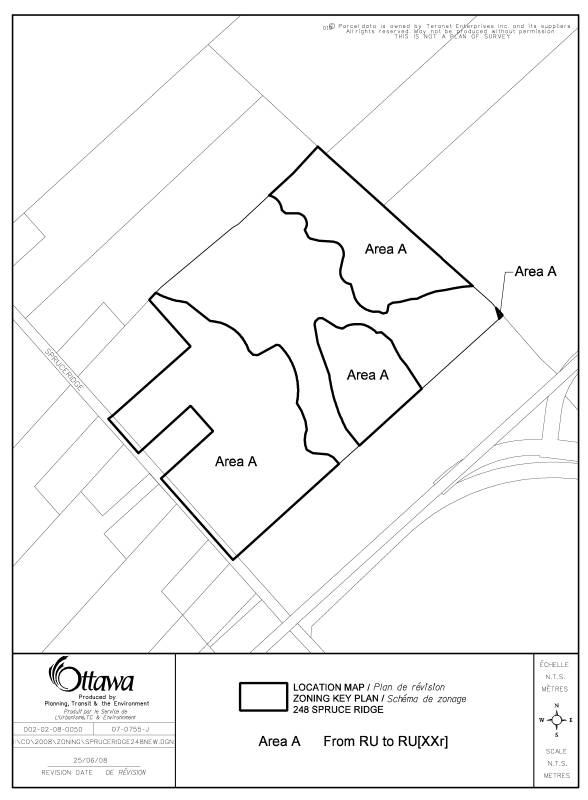
The new Comprehensive Zoning By-law identifies the subject lands as being within the RU (Rural Countryside) and EP3 (Environmental Protection Subzone 3) zones. The RU zone on the subject lands is proposed to be amended to create a new RU [xxr] (Rural Countryside—Exception) zone as detailed in Document 1 and shown in Document 3. The exception will establish the 120-metre “no development” zone.
Consent application D08-01-07/B-00428 was approved by the Committee of Adjustment, subject to approval of the proposed Zoning By-law.
Summary
The proposed Zoning By-law amendment will restrict development within and adjacent to the wetland, which is consistent with the relevant policies in the Provincial Policy Statement and the Official Plan. The Department therefore recommends approval of this Zoning By-law amendment.
ENVIRONMENTAL IMPLICATIONS
The proposed Zoning By-law amendment will establish appropriate setbacks for development for the protection of the Provincially Significant Wetlands existing on the property.
RURAL IMPLICATIONS
The severance permits rural development while preserving the rural natural features affecting the property.
CONSULTATION
Notice of this application was carried out in accordance with the City's Public Notification and Consultation Policy. The Ward Councillor is aware of this application and the staff recommendation. The City did not receive any negative comments or opposition to this application.
FINANCIAL IMPLICATIONS
APPLICATION PROCESS TIMELINE STATUS
This application was processed by the "On Time Decision Date" established for the processing of Zoning By-law amendment applications.
SUPPORTING DOCUMENTATION
Document 1 Details of Recommended Zoning
Document 2 Changes to West Carleton Zoning By-law
Document 3 Changes to New Comprehensive Zoning By-law
DISPOSITION
City Clerk’s Branch, Council and Committee Services to notify the owner, Matt Hyde, Hyde Park A living presence in Canada, 1 Neely Street, Dunrobin, Ontario. K0A 1T0, OttawaScene.com, 174 Colonnade Road, Unit #33, Ottawa, ON K2E 7J5, Ghislain Lamarche, Program Manager, Assessment, Financial Services Branch (Mail Code: 26-76) of City Council’s decision.
Planning, Transit and the Environment Department to prepare the implementing by-law, forward to Legal Services Branch and undertake the statutory notification.
Legal Services Branch to forward the implementing by-law to City Council.
DOCUMENT
1
DETAILS OF RECOMMENDED ZONING
Proposed
Changes to By-law 266/81 – former West Carleton
The lands shown on Document 1 will be rezoned from RU to HL-1 and from RU to RU-XX on Schedule A – Map 3
The lands zoned RU-XX are subject to the following provisions:
Development on lands zoned RU-XX must respect a 120 metre no development setback from the boundary of the Provincially Significant Wetland as shown on Schedule A. For the purposes of this by-law the no development setback will prohibit buildings and structures and site grade alterations including, but not limited to excavation and placement of fill within 120 metres of the wetland boundary.
Proposed
Changes to new Comprehensive Zoning By-law
The lands shown on Document 3 will be rezoned from RU to RU[xxr] on the zone maps.
The lands zoned RU[xxr] are subject to the following provisions:
Development on lands zoned RU[xxr] must respect a 120-metre no development setback from the boundary of the Provincially Significant Wetland as shown on the zone map. For the purposes of this by-law the no development setback will prohibit buildings and structures and site grade alterations including, but not limited to excavation and placement of fill within 120 metres of the wetland boundary.
CHANGES TO WEST CARLETON ZONING BY-LAW
REVISED DOCUMENT 2
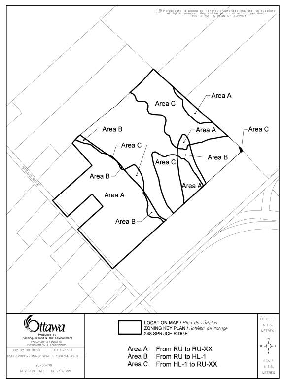
CHANGES
TO NEW COMPREHENSIVE ZONING BY-LAW
REVISED DOCUMENT 3