|
3. BRIDGE STREET - TRUCK ROUTE MOTION RUe BRIDGE – Motion sur les itinéraires des camions |
committee recommendation
That
Council approve that Bridge Street in
Manotick remain in the Truck Route System as currently designated under
schedule ‘XL’ of the Traffic and Parking By-law No. 2003-530.
Recommandation du comité
Que le Conseil approuve que la rue Bridge à Manotick
demeure dans le réseau des itinéraires pour camions, telle qu’elle est
actuellement désignée en vertu de l’Annexe « XL » du Règlement no
2003-530 régissant la circulation et le stationnement.
Documentation
1. Deputy City Manager’s report (Public
Works and Services) dated 29 September 2008 (ACS2008-PWS-TRF-0019).
2. Extract of Draft Minute, 15 October 2008.
Report
to/Rapport au :
Comité des transports
and Council / et au Conseil
29 September 2008 / le 29 septembre
008
R.G. Hewitt, Deputy City
Manager/Directeur municipal adjoint,
Public Works and Services/Services
et Travaux publics
Contact Person/Personne ressource : Michael J. Flainek, M.Eng., P.Eng.,
Director/Directeur
Traffic
and Parking Operations/Circulation de stationnement
613-580-2424
ext. 26882, Michael.Flainek@ottawa.ca
SUBJECT:
|
|
|
|
|
OBJET :
|
RUe BRIDGE – Motion sur les itinéraires
des camions |
REPORT RECOMMENDATION
That Transportation
Committee recommend to Council that Bridge Street in Manotick remain in the
Truck Route System as currently designated under schedule ‘XL’ of the Traffic
and Parking By-law No. 2003-530.
RECOMMANDATION DU RAPPORT
Que le Comité des transports recommande au Conseil que
la rue Bridge à Manotick demeure dans le réseau des itinéraires pour camions,
telle qu’elle est actuellement désignée en vertu de l’Annexe « XL »
du Règlement no 2003-530 régissant la circulation et le
stationnement.
BACKGROUND
This Report is a response
to Motion 30/13 tabled at the 23 January 2008 meeting of Council:
“That the
Rules of Procedure be waived to consider and approve the following motion:
WHEREAS the south end of our City continues to experience significant growth; and
WHEREAS an additional bridge is needed to
accommodate the increased traffic loads across the Rideau River at Manotick;
and
WHEREAS the
amount of heavy truck traffic contributes to significant traffic delays within
and surrounding the Village of Manotick;
THEREFORE
BE IT RESOLVED that City Council direct staff to prepare a report for
Transportation Committee and City Council by mid-summer that examines and
assesses the feasibility of removing Bridge Street from the Truck Route System
under schedule XL of the Traffic Control By-Law so that heavy truck traffic is
restricted from using this residential neighbourhood as a truck route; and
BE IT FURTHER RESOLVED that
staff be directed to prepare an information report by late spring for
Agriculture and Rural Affairs Committee that assesses paramedic and fire
response times to the south end of Long Island at peak hours.”
Note: In response to the latter resolution, the
Agriculture and Rural Affairs Committee received comments from Paramedic
Service and Fire Services on 12 June 2008, attached as Document 1. The Minutes of that meeting pertaining to
this issue are attached as Document 2.
DISCUSSION
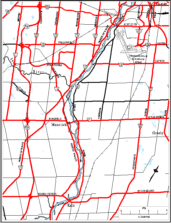
Bridge Street in Manotick is part of the Truck Route System and serves as one of only two crossing points of the Rideau River south of the Hunt Club Bridge. Any traffic diverted from Bridge Street would have to travel either 13 km north to the Hunt Club Bridge or 10 km south to the Kars Bridge, to cross the river. Effectively then, if Bridge Street is removed from the Truck Route System, operators of those diverted vehicles could face additional time and operating costs in travelling the additional distances, to cross the river at an adjacent bridge. A map of the area is attached as Document 3.
Classification and Occupancy
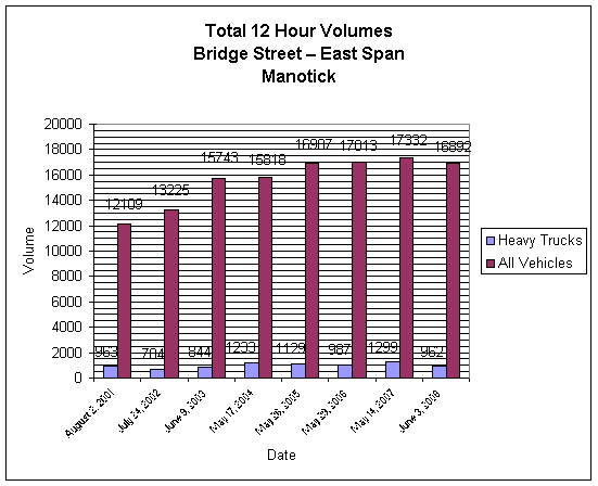
(C&O) counts taken annually on Bridge Street since 2001 are summarized in Document 4. They reveal that heavy trucks have consistently comprised 5.3 to
8.0 per cent of vehicle flows on Bridge Street. For consistency and to facilitate comparisons for planning needs,
C&O counts are conducted for 12 hours (0700 to 1900), weekdays, Monday to
Thursday. The most recent count
conducted on Tuesday 3 June 2008, revealed total two-way traffic during that
12-hour period of 16,892 vehicles of which 962 (or 5.7 per cent) were heavy
trucks. That heavy truck percentage is
typical of most truck routes.
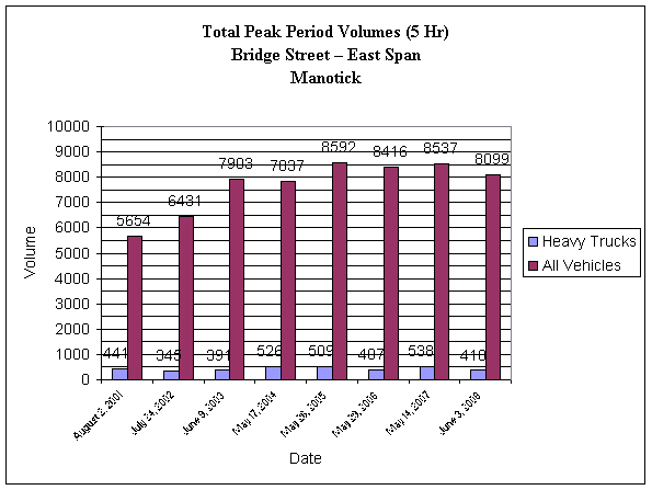
For the most part, vehicles flow freely on Bridge Street except during weekday peak periods. Again, for consistency, C&O outputs identify peak periods as being the 5-hour sum of the (0700 to 0930) period and the (1530 to 1800) period. Peak period volumes from 2001 to 2008 are summarized in Document 5. It shows that between 2001 and 2008, 5-hour peak period volumes (all vehicles) ranged from a low of 5,654 units in 2001 to high of 8,592 units in 2005, while peak period heavy truck volumes ranged from a low of 345 in 2002 to a high of 538 in 2007. The June 2008 count shows that during the 5-hour peak period, a total of 8,099 vehicles used Bridge Street, of which 410 (or 5.1 per cent) were heavy trucks.
Direct comparison of the 2001 peak period data against the 2008 peak period data shows that while total 5-hour peak period volumes increased from 5,654 units in 2001 to 8,099 in 2008 (+43 per cent), peak period heavy truck traffic actually decreased from 441 units in 2001 to 410 units in 2008 (-7.0 per cent).
Based on the foregoing then, and considering that Motion 30/13 to which this report is responding, specifically notes that “…the amount of heavy truck traffic contributes to significant traffic delays within and surrounding the Village of Manotick” – a situation that may only arise during peak periods - it appears fair to say that based on peak period counts taken during the past 8 years, Bridge Street automobile traffic has increased at a far greater pace than has truck traffic. Furthermore, as field observations indicate that a high percentage of trucks using Bridge Street are conveying construction equipment and building materials, it is also reasonable to conclude that periods of increased truck activity at this river crossing, are closely tied to ebbs and flows of new housing starts on both sides of the Rideau River, within the south urban area.
a) Assumptions
To provide some order of magnitude in discussing the impacts of a truck ban on Bridge Street, the following analysis is provided. This is not intended to be detailed or comprehensive; rather, it is offered as a starting point to outline some obvious concerns and to raise awareness of some less obvious concerns, should Council wish to proceed with a truck-ban. To provide a framework for this analysis, some assumptions are required, specifically:
- If heavy trucks were banned from Bridge Street, operators would choose one adjacent bridge or the other and thus face the additional time and expense of making, on average, a 20 km round-trip to use either the Kars Bridge or the Hunt Club Bridge.
- Depending on the exact origin and destination of each trip, the choice of alternative crossing would usually be based on a desire to minimize overall travel time.
- To determine origins and destinations of truck trips using Bridge Street, detailed and costly surveys are required. Either each truck must be traced through the arterial road network in the vicinity of Bridge Street (by recording turns and license plate numbers), or, each truck observed using Bridge Street must be stopped and the driver interviewed to find out where the truck is coming from and going to.
4. Without that origin-destination information, our analysis will assume that all diverted trucks will result in extra travel. While truckers would no doubt try to minimize that increased distance by adjusting their route to provide the most direct connection between their point of origin and their destination, we will assume that they must travel, on average, 20 km extra, whether to use the Kars Bridge or Hunt Club Bridge crossings.
- Without conducting 24-hour counts to determine daily heavy truck volumes, our analysis will ignore all truck volumes between the hours of 7:00 p.m. (1900) and 7:00 a.m. (0700). It will therefore be confined to the 12-hour (0700 to 1900) period only.
- Without knowing what weekend truck volumes are on Bridge Street, our analysis will ignore them and be confined to weekdays only. To further simplify calculations, we will consider only 250 weekdays per year – to compensate for statutory holidays.
- Without knowing exactly what the operating speeds of heavy trucks may be while using the diversion routes, our analysis will assume an average speed of 60 km/h – a value that is totally unrealistic for peak periods but one that may also be usually exceeded in off-peak periods. Again, this value has been selected to provoke thought and establish an order of scale.
b) Concerns
Arising from a Truck Ban on Bridge Street
Based on the foregoing assumptions, if heavy trucks were prohibited from using Bridge Street at “anytime” (24 hours per day), it would result in the diversion of at least 962 truck trips per day. This in turn would result in at least 4.81 million km of additional truck travel per year (i.e. 962 trips @ 20 km each for 250 weekdays per year) and approximately 80,000 hours of additional truck operating time per year (i.e. 4.81 million km, at an average speed of 60 km/h).
If trucks were banned on Bridge Street for weekday peak periods only (i.e. 0700 to 0930 and 1500 to 1800), an additional 2.05 million km of truck travel and approximately 34,000 hours of additional truck operating time would result annually (i.e. 410 trips @ 20 km each for 250 weekdays per year, at an average speed of 60 km/h).
Either way, during peak periods, a truck ban
would divert 410 heavy trucks from Bridge Street to the adjacent bridges and
would also add those volumes to the connecting road links. Hunt Club Bridge is already heavily
congested in peak periods (during which its volume to capacity ratio routinely
exceeds 1.0); therefore, any additional truck traffic shifted to that crossing would
only compound that problem.
Accordingly then, four very obvious impacts of a truck ban on Bridge Street are:
1. Additional costs to the owners and operators of those diverted trucks;
2. Additional costs for goods and commodities transported by those vehicles;
3. Additional peak-period congestion on adjacent bridges and diversion roads; and,
4. Additional safety risks to diversion road users.
c) Other
Considerations
There are also less obvious impacts that will arise from a truck ban on Bridge Street.
The most important of these is the adverse impacts on the environment created by the additional greenhouse gas (GHG) emissions. From that perspective, the additional GHG emissions would not simply be those produced by trucks in travelling the extra 4.81 million km distance annually (to use alternative bridges), but also would include additional GHG emissions produced by all of the other vehicles that would be further delayed, in crossing Hunt Club Bridge and travelling through the heavily congested arterial road network in that area, as a result of those diverted truck trips being added to those facilities.
References on GHG emissions from Environment Canada and other sources are shown in Document 6. Application of factors from those references reveal that 4.81 million km of additional heavy truck travel per year, assuming those trucks are diesel powered (as the vast majority of heavy trucks are), would result in the generation of some additional 21.89 tonnes of carbon monoxide, 5.24 tonnes of carbon dioxide and 28.96 tonnes of nitrogen oxide annually.
A second less obvious concern is that of “fair play” in the goods movement industry. Without knowing precisely what each and every truck is currently hauling, it is nonetheless apparent that a high percentage of truck traffic on Bridge Street is related to the construction industry - since they are hauling heavy equipment (hi-hoes, stone slingers and boom trucks) and commodities such as sand, gravel, concrete, lumber, shingles, roof trusses, bricks, sod and topsoil. Some of those commodities (sod, topsoil and granular material) are produced by local sod farms and quarry operators. Therefore, any additional transportation costs those companies encounter can weaken their ability to compete on a level playing field with competitors selling the same commodities but delivering them from the opposite side of the river, and who therefore are not required to contend with additional distance and travel-time constraints imposed by a truck ban on Bridge Street. Obvious examples would include businesses in Greely wishing to haul sod and topsoil to Barrhaven or sand and gravel firms on Moodie Drive wishing to haul aggregate to Riverside South.
There are a significant number of retail businesses within Manotick and virtually all of them including the Independent Grocer, LCBO outlet and Home Hardware in the Mews, are either on, or in, close proximity to Rideau Valley Drive and that road is part of the Truck Route System.
Truckers are permitted to deviate from the Truck Route System for local deliveries but the Traffic and Parking By-law specifies that all, “such deviations from truck routes are to be direct – i.e. made from the point on a truck route nearest by highway distance to the premise referred to above.” This means that if trucks are banned on Bridge Street, then all deliveries to those establishments must be made from roads on the west side of the Rideau River, such as Prince of Wales Drive or Bankfield Road. This will no doubt require adjustments to delivery routes and schedules.
Finally, drivers intent on making deliveries as expeditiously as possible, usually choose the most direct routes possible. Bridge Street has been part of the Truck Route System for at least the past 35 years and experience has clearly shown that heavy truck operators are reluctant to embrace any changes to the Truck Route System unless they themselves derive some benefit. In our opinion, a truck ban on Bridge Street will not be well complied with unless augmented with rigorous enforcement. Accordingly, those additional enforcement costs and resource requirements must be considered.
In summary, there are numerous impacts and considerations that arise from changes to the Truck Route System. No one wants trucks using their road or travelling through their community, and yet, most people acknowledge the need for a network that facilitates goods movement.
Truck routes must consider many things including noise, vibrations, emissions and public safety. Proposed changes to the established Truck Route System must also consider collateral impacts on diversion routes, intersections and bridges. Since all diversions can adversely affect the economic livelihood of suppliers and competitiveness within the trucking industry itself, it is imperative that extensive public consultation be conducted beforehand, so that all concerns are recognized as part of that decision making process.
That sensitivity to change in the Truck Route System is acknowledged in Section 9.8 (5) of the Transportation Master Plan wherein it states:
“The City will consult with the trucking industry, the
business community and the public to resolve goods movement issues and balance
community needs with those of road users.”
From a traffic management perspective, it cannot be over emphasized, that if changes to the Truck Route System are contemplated, they be considered comprehensively. That is, on the system as a whole, and not piecemeal – one road section at a time. Transportation Committee endorsed that position in November 2005 when they approved the Truck Route Designation Policy. At that time, in view of the extensive public consultation required, it was estimated that a study to review the Truck Route System in its entirety would require funding of $150,000.
Conclusion
The foregoing discussion and high-level analysis is intended to provoke thought and provide insight into the possible impacts of a truck ban on Bridge Street. It does not attempt to quantify additional transportation or enforcement costs, nor does it attempt to quantify benefits resulting from reduced congestion and GHG emissions on Bridge Street as a result of diverted truck trips. Nonetheless, it does point out that there are major cost and environmental implications associated with the deletion of Bridge Street from the Truck Route System. Therefore, considering that:
- Heavy trucks currently comprise 5.7 per cent of all traffic using Bridge Street in Manotick – a percentage typical of most roads in the Truck Route System.
- The diversion of those trucks to the Kars and Hunt Club Bridges would result in the addition of some 4.81 million km of additional truck travel and 80,000 hours of needless additional truck operating time per year.
- Those diesel-powered trucks travelling the additional 4.81 million km/yr will generate some 21.89 tonnes of carbon monoxide, 5.24 tonnes of carbon dioxide and 28.96 tonnes of nitrogen oxide annually.
- That impact will be challenged by the trucking industry and opposed by all those who are environmentally conscientious.
- Public consultation has not been undertaken to ascertain the impacts that could arise from a truck ban on Bridge Street, on the trucking industry, the business community or the public to balance community needs with those of the goods movement industry and other road users – as a stipulated requirement of the City, under Section 9.8 (5) of the Transportation Master Plan.
- Transportation Committee, in approving the Truck Route Designation Policy in November 2005, endorsed the notion that changes to the Truck Route System should only be made following a comprehensive review of that system as a whole.
- Bridge Street has been a long-standing and vital part of the Truck Route System for at least the past 35 years and it is unlikely that a truck ban will be well complied with unless augmented with rigorous enforcement.
It is the opinion of the Departmental staff that it is not appropriate, to delete Bridge Street from the Truck Route System, even for peak periods only. However, in keeping with a desire to balance community needs with those of road users, this matter could be reviewed again, once a new bridge is constructed to address the urgent transportation challenges precipitated by the rapid growth of the south urban area.
CONSULTATION
Since this review was intended
only to examine the feasibility of removing Bridge Street from the Truck Route
System, no public consultation has been undertaken.
FINANCIAL IMPLICATIONS
There are no financial
implications associated from the recommendation.
However,
should Council direct Traffic and Parking Operations Branch staff to undertake
a comprehensive review of the Truck Route System, then Council would need to
recommend that a Strategic Initiatives Capital Project in the amount of
$150,000 be submitted for Council consideration as part of the 2009 Draft
Capital Budget for a Truck Route System Study.
SUPPORTING DOCUMENTATION
Document 1 Memo in response to Motion 30/13 tabled at the 23 January 2008 meeting of Council from Paramedic Services and Fire Services
Document 2 Excerpt from Agriculture and Rural Affairs Committee Minutes – 13 June 2008
Document 3 Map of Manotick – Bridge Street
Document 4 12-Hour Bridge Street Summary Classification and Occupancy 2001 - 2008
Document 5 5-Hour Bridge Street Summary Classification and Occupancy 2001 – 2008
Document 6 Greenhouse Gas
Emissions
DISPOSITION
Upon approval of this report, staff of the Public Works and Services Department, Traffic and Parking Operations Branch, will proceed as per Council’s direction.
DOCUMENT 1
MEMO IN RESPONSE TO MOTION 30/13 TABLED AT THE 23
JANUARY 2008
MEETING OF COUNCIL FROM PARAMEDIC SERVICES AND FIRE
SERVICES
M E M O /
N O T E D E S E R V I C E
|
|

|
To / Destinataire |
Mayor and Members of Council |
File/N° de fichier: ACS2008-CPS-DCM-0004-IPD |
|
From / Expéditeur |
Deputy City Manager/Directeur municipal adjoint, Community and Protective Services/Services
communautaires et de protection |
|
|
Subject / Objet |
Response to Council Motion
30/13 - Paramedic and Fire Response Times to the South End of Long Island at
Peak Hours /
Réponse du Conseil à la motion 30/13 – délais d’intervention des services
Paramédic et d’Incendie à l’extrémité sud de Long Island aux heures de pointe |
Date: 5 June 2008 / le 5 juin 2008 |
This memo is a response to Motion 30/13 tabled at the 23
January 2008 meeting of
Council:
That the Rules of Procedure be waived to consider
and approve the following motion:
WHEREAS the south end of our City continues to
experience significant growth; and
WHEREAS an additional bridge
is needed to accommodate the increased traffic loads across the Rideau River at
Manotick; and
WHEREAS the amount of heavy truck traffic
contributes to significant traffic delays within and surrounding the Village of
Manotick;
THEREFORE BE IT RESOLVED that City Council direct
staff to prepare a report for Transportation Committee and City Council by
mid-summer that examines and assesses the feasibility of removing Bridge Street
from the Truck Route System under schedule XL of the Traffic Control By-Law so
that heavy truck traffic is restricted from using this residential
neighbourhood as a truck route; and
BE IT FURTHER RESOLVED that staff be directed to
prepare an information report by late spring for Agriculture and Rural Affairs
Committee that assesses paramedic and fire response times to the south end of
Long Island at peak hours.
This information memo
responds to the last portion of the motion relating to Paramedic and Fire
Services response times.
Data analysis indicates the
response times to the south end of Long Island during peak hours are not an
issue for both Paramedic Service and Fire Services as described in the
following.
Paramedic Service:
Paramedic Services conducted
several test responses from the Manotick Paramedic post located at 5669 Main
Street to the south end of Long Island. The results suggest that response times
would not be affected in response to traffic, as the drive time of each event
was less than 6 minutes. The test
drives were performed without lights and sirens and respected the 'rules of the
road' wherein speed limits, traffic lights and directional signs were observed.
This data demonstrates that
response times to the south end of Long Island fall within the established
performance targets of 15 minutes 59 seconds 90% of time for life-threatening
calls in Ottawa’s low-density area.
Fire Services:
A review of the historical
data indicates that there have been four actual emergency responses to the
south end of Long Island since 2004. In all four instances the travel time was
less than 6 minutes.
Several additional scenarios
were developed utilizing the station location modeling program and the results
were similar. In addition to reviewing the data from the Manotick Station
located at 5669 Main Street response times from the prime back-up station
located at 910 Earl Armstrong Road to Long Island indicated a consistent
arrival time of less than 9 minutes.
Overall fire service to the
island has been enhanced with the ability to deploy multiple stations due to a
centralized dispatch and best station deployment practices that have been
implemented since amalgamation.
Steve Kanellakos
cc: Kent Kirkpatrick, City Manager
Carole Langford, Committee
Coordinator Agriculture and Rural Affairs Committee
DOCUMENT 2
EXCERPT
FROM Agriculture and Rural Affairs Committee
minutes 25
- 12 june 2008
INFORMATION PREVIOUSLY DISTRIBUTED
INFORMATION
DISTRIBUÉE AUPARAVANT
a. Response to Council Motion 30/13 -
Paramedic and Fire Response Times to the South End of Long Island at Peak Hours
Réponse du Conseil à
la motion 30/13 – délais d’intervention des services Paramédic et d’Incendie à
l’extrémité sud de Long Island aux heures de pointe
ACS2008-CPS-DCM-0004-IPD (RIDEAU-
GOULBOURN WARD 21)
Appearing before the Committee on this item were Gord Mills, Deputy Chief of Rural Services and Paul Hutt, Sector Chief for District 9. Deputy Chief Mills provided a preliminary explanation of the response times to the south end of Long Island during peak hours. He outlined the 2007 statistics, which showed that 36 calls were taken with four of those responses going to South Island at various times of the day. The following provides a more defined description of each call:
· 8:00 - Five minute response to Van Vliet
· 11:56 - Six minute response time to South River Drive
· 17:48 - Five minute and 25 seconds to South Island Park Drive
· 21:00 - Four minute response time to South Island Park Drive
He believed that the increased volumes on the bridge would have little or significantly low impact on the response times. Further, staff ran scenarios utilizing the Station Location Modelling Program. This program allowed staff to gain more information by using various distances within a district at different times with a variety of factors that may affect response times. It also provided statistics with respect to the back up station at Earl Armstrong Road in Barrhaven, which were also able to get to South Island within nine minutes.
In response to questions from Councillor El-Chantiry, Deputy Chief Mills advised that there is minimal impact on the response times since they have the ability to get around the traffic and he added that the bridge is wide enough to get through even if there is traffic on both sides.
Brian Tansley advised that he submitted a request for information through the RIAC regarding emergency services provision, not only for South Island, but for all of the Village of Manotick. He believes that the level of service on Bridge Street is approaching unacceptable levels of service especially during peak hours and is gradually extending with time so that traffic is jamming access to the island. Notwithstanding the statistics, the residents continue to be concerned regarding the trend, which shows there are significant times during the peak periods (being during weekdays and/or weekdays) when the bridges are blocked. In his opinion, there is no way that emergency vehicles could get across the bridge in any direction. His primary concern is that he does not believe access to paramedic, fire and police services is going to continue effectively at the present rate, given the traffic intensity that they have observed.
In response to a question by Councillor Thompson, Sector Chief Hutt advised that one of the studies currently being reviewed is the old deployment model. Regardless of the incident, they would have resources covering the area. He added that Manotick also has a volunteer fire department, including residents living throughout the community who offer updates to the fire department and the Chief officers.
Sector Chief Hutt advised that Fire Services continuously works closely with the Emergency Measures Services and Police Services so if it is a matter of shutting down an intersection to improve a response time, those resources are there to be used.
Mr. McKinley informed the Committee that he was involved in helping the Manotick Community Association when this request for information was put forward. He noted that staff did not answer the question that was put forward, which is quoted as “Could you please determine whether during peak times, if the bridge represents an impediment that would delay response times to an unacceptable level.” The idea being that it might be of some assistance to staff and provide justification to redirect commercial traffic to other more appropriate locations. For the people who live there and see conditions during peak times, trucks backed up for several miles and moving in neither direction, it does not make sense that one single response at 8 am represents a fair assessment of the question.
Councillor Jellett thought that the delegate had a valid point, since Council had asked that a staff report go back to TRC on this issue.
Chief Mills responded that he was a sector chief for that area for four years and Chief Hutt has been responsible for that area since that time and in his experience, there has not been a time when fire trucks have been unable to pass along that bridge. He explained that when vehicles are parked or waiting for traffic lights and they are following one behind the other, they move over to the side to allow an emergency vehicle that is en route to a scene to by-pass them. In the same way that traffic moves downtown, vehicles move to the side, allowing fire trucks to pass down the middle in case of emergency.
Chair Jellett emphasized that the increase in commercial vehicles could in fact cause a problem in the future.
Councillor Brooks noted that it was his motion that asked staff to proceed with a study to see if trucks can be relocated to other routes. He suggested having fire drills at peak hours in order to prove the theory. Deputy Chief Hutt agreed with Councillor Brooks and referred to his suggestion as a Priority One response, although he felt Legal would probably suggest that it is not a likely thing to do. He suggested doing dry runs (no lights or sirens) during peak times. He added that EMS also regularly do dry runs during peak times.
RECEIVED
DOCUMENT 3
MAP OF MANOTICK – BRIDGE STREET
DOCUMENT 4
12 Hour
Bridge Street Summary Classification and
Occupancy
2001 – 2008
|
Manotick Total 12 Hour Volumes |
|||
|
|
|
|
% Of Trucks |
|
Date |
All Vehicles |
Heavy Trucks |
|
|
August 2, 2001 |
12109 |
963 |
8.0% |
|
July 24, 2002 |
13225 |
704 |
5.3% |
|
June 9, 2003 |
15743 |
844 |
5.4% |
|
May 17, 2004 |
15818 |
1233 |
7.8% |
|
May 26, 2005 |
16907 |
1129 |
6.7% |
|
May 29, 2006 |
17013 |
987 |
5.8% |
|
May 14, 2007 |
17332 |
1299 |
7.5% |
|
June 3, 2008 |
16892 |
962 |
5.7% |
DOCUMENT 5
5-HOUR BRIDGE STREET SUMMARY CLASSIFICATION AND
OCCUPANCY 2001 – 2008
|
Manotick Total Peak Period
Volumes (5 Hr) |
|||
|
|
|
|
% Of Trucks |
|
Date |
All Vehicles |
Heavy Trucks |
|
|
August 2, 2001 |
5654 |
441 |
7.8% |
|
July 24, 2002 |
6431 |
345 |
5.4% |
|
June 9, 2003 |
7903 |
391 |
4.9% |
|
May 17, 2004 |
7837 |
526 |
6.7% |
|
May 26, 2005 |
8592 |
509 |
5.9% |
|
May 29, 2006 |
8416 |
407 |
4.8% |
|
May 14, 2007 |
8537 |
538 |
6.3% |
|
June 3, 2008 |
8099 |
410 |
5.1% |
DOCUMENT 6
GREENHOUSE GAS EMISSIONS
Highway Base Emission Factors, Grams per Kilometre
|
|
LDGV |
LDGT |
HDGV |
LDDV |
LDDT |
HDDV |
|
Year = 2005 |
||||||
|
VOC |
0.54748 |
0.70316 |
1.15316 |
0.25208 |
0.31802 |
0.40498 |
|
CO |
5.13711 |
5.57498 |
11.62512 |
0.67593 |
0.71343 |
4.54890 |
|
NOx |
0.62086 |
0.73239 |
3.74106 |
0.65099 |
0.70747 |
6.02128 |
|
SOx |
0.00356 |
0.00188 |
0.00786 |
0.04352 |
0.05524 |
0.02930 |
|
PM10 |
0.00304 |
0.00346 |
0.02788 |
0.06907 |
0.07250 |
0.19919 |
|
PM2.5 |
0.00280 |
0.00313 |
0.02135 |
0.06354 |
0.06670 |
0.18325 |
|
CO2 |
0.23364 |
0.31388 |
0.47200 |
0.27300 |
0.35490 |
1.08927 |
|
Year = 2010 |
||||||
|
VOC |
0.35366 |
0.43227 |
1.00371 |
0.25931 |
0.33266 |
0.26965 |
|
CO |
3.71323 |
3.77966 |
10.04808 |
0.68471 |
0.72674 |
4.53414 |
|
NOx |
0.36392 |
0.46748 |
3.43897 |
0.64720 |
0.71599 |
5.19319 |
|
SOx |
0.00357 |
0.02837 |
0.00767 |
0.04185 |
0.05414 |
0.02837 |
|
PM10 |
0.00303 |
0.00337 |
0.02226 |
0.06240 |
0.06775 |
0.14822 |
|
PM2.5 |
0.00280 |
0.00305 |
0.01758 |
0.05741 |
0.06249 |
0.13636 |
|
CO2 |
0.21476 |
0.30444 |
0.47200 |
0.27300 |
0.35490 |
1.05378 |
|
Vehicle
Type |
Description |
|
LDGV |
Gasoline fueled cars |
|
LDGT |
Pick-ups and commercial vans |
|
HDGV |
Gasoline-fueled trucks |
|
LDDV |
Diesel fueled cars |
|
LDDT |
Diesel fueled trucks < 8500 lb. |
|
HDDV |
Diesel fueled trucks > 8500 lb. |
VOC = Volatile Organic Compounds
Volatile organic compounds are a large and diverse family of chemicals that contain carbon and hydrogen. They can be emitted into air from a variety of sources including cigarette smoke, vehicle exhaust and building materials such as paint.
CO = Carbon Monoxide
Carbon Monoxide is a colourless, odourless gas that reduces the amount of oxygen in the blood.
NOx = Nitrogen Oxide
Nitrogen oxides include the gases nitrogen oxide (NO) and nitrogen dioxide (NO2). NOx is formed primarily from the liberation of nitrogen contained in fuel and nitrogen contained in combustion air during combustion processes.
SOx = Sulfur Oxide
A general
term used to describe the oxides of sulfur - pungent, colorless gases formed
primarily by the combustion of fossil fuels. Sulfur oxides, which are
considered major air pollutants, may damage the respiratory tract as well as
vegetation.
PM = Particulate Matter
PM consists
of tiny solid and liquid particles that come from a myriad of sources including
fuel combustion from automobiles, power plants, wood burning, industrial
processes, and diesel-powered vehicles such as buses and trucks.
CO2 = Carbon Dioxide
Carbon dioxide (CO2) is the most important greenhouse gas
produced by human activities, primarily through the combustion of fossil fuels.
Sources:
·
CAC
Emissions Factors – Christian Vzina. Pollution Data Branch. Environment Canada.
August 2001. Contact (819) 994-2975
·
GHG
Emission Factors – Canada’s Greenhouse Gas Inventory: 1990-1998. Final
Submission to the UNFCCC Secretariat. October 2000. Volume 1 of 2.
·
Environment
Canada confirming the test procedures (speed) at which the CAC emission factors
were calculated
·
Grams
per liter to grams per kilometer conversion based on fuel efficiency figures
estimated by Joycelyn Exeter. Analysis Modelling Division. Natural Resources
Canada. July 2001.
·
Definitions of substances from Health Canada,
Environment Canada, the Environmental Science Division, The Environmental
Protection Division, U.S. Environmental Protection Agency, and The Encyclopedia
of Earth