1.                   Prince of wales drive (fisher avenue to woodroffe avenue) environmental assessment study – recommended plan


Étude d’évaluation environnementale de la promenade prince of wales (de l’avenue fisher À l’avenue woodroffe) – plan recommandÉ


Committee recommendationS AS AMENDED


That Council:


1.                  Receive the results of the Prince of Wales Environmental Assessment Study as proposed in document 1;


2.                  Direct staff to finalize the Environmental Study Report and proceed with its posting for the 30-day public review period in accordance with Ontario Municipal Class Environmental Assessment, Schedule "C" process;


3.                  Direct staff to work with the National Capital Commission to fulfill the requirements of the Canadian Environment Assessment Act in accordance with the principles of the Environment Study Report;


4.                  Direct staff to undertake necessary property acquisition for the construction of Prince of Wales Drive, in line with the timing identified in the Transportation Master Plan and through the annual Capital Budget Process;


5.         Direct staff to advocate in discussions with the NCC the implementation of option B with regard to noise barrier placement and design on Prince of Wales; and


            Direct staff to undertake further detailed studies pertaining to the noise fence options to address design, cost, and visual impact.


            6.         Approve that the recommendations for road alignment and design set out in the design review report provided by Delcan and dated May 27, 2011 (scenario #1) be incorporated into the current Environmental assessment report, such that it amends the current proposed alignment design, with the objective of avoiding any property acquisition within the Waterford, Amberwood and Yewfield area.


7.         Approve that as part of the design process, City staff review opportunities for berming and landscaping to provide some green screening to homes adjacent to Prince of Wales, including additional planting opportunities along the stormwater ponds.


8.         Request funding assistance for the design and construction of two cattle crossing culverts from the National Capital Commission.


9.         Approve that, as part of the detailed design phase, City staff develop a phased construction plan.


            10.       Approve that, as part of the 2012 budget process, City staff review opportunities to begin design work in 2012 for Prince of Wales intersections that are experiencing peak hour failures such as Hunt Club and Prince of Wales, and Fallowfield and Prince of Wales.


11.       Approve that staff be directed to work with the owner of 2175 Prince of Wales to determine a means of providing all directional access to the site through the site plan process.


RecommandationS modifiée du comité


Que le Conseil :


1.         prenne connaissance des résultats de l’étude d’évaluation environnementale concernant la promenade Prince of Wales, tel que proposé dans le document 1;


2.                  demande au personnel de finaliser le rapport d’étude environnementale et soumette à l’examen du public pendant trente jours, conformément au processus d’évaluation environnementale municipale de portée générale de l’Ontario (annexe C);


3.                  demande au personnel de collaborer avec la Commission de la capitale nationale afin de satisfaire aux exigences de la Loi canadienne sur l’évaluation environnementale, conformément aux principes qui sous-tendent le rapport d’étude environnementale; et


4.                  demande au personnel d’acquérir les terrains nécessaires à l’élargissement de la promenade Prince of Wales, selon le calendrier indiqué dans le Plan directeur des transports et en fonction du budget des immobilisations annuel.


5.         demande au personnel, dans ses discussions avec la CCN, de promouvoir la mise en œuvre de l’option B en ce qui concerne l’emplacement et la conception des écrans antibruit de la promenade Prince of Wales.


demande au personnel de mener des études approfondies en ce qui a trait à la conception, au coût et aux effets visuels des écrans antibruit.


6.         approuve que les recommandations concernant le tracé et la conception de la route énoncées dans le rapport d’examen de la conception produit par la société Delcan en date du 27 mai 2011 (scénario no 1) soient intégrées au rapport d’évaluation environnementale, de façon à modifier la conception projetée du tracé, dans le but d’éviter l’acquisition de terrains dans le secteur de la promenade Waterford, du croissant Amberwood et de la cour Yewfield. 


7.         approuve que, dans le cadre du processus de conception, le personnel de la Ville examine les possibilités d’aménagement de bermes et de mise en place d’aménagements paysagers, y compris la possibilité de procéder à des plantations supplémentaires le long des bassins de rétention des eaux pluviales, afin d’offrir un écran de verdure pour les résidences contiguës à la promenade Prince of Wales;


8.         demande une aide financière à la Commission de la capitale nationale pour la conception et la construction de deux ponceaux pour le passage du bétail;


9.         approuve que, dans le cadre de la conception détaillée, le personnel de la Ville élabore un plan de construction par étape;


10.       approuve que dans le cadre du processus budgétaire de 2012, le personnel de la Ville examine les possibilités d’entreprendre en 2012 les travaux de conception concernant les intersections de la promenade Prince of Wales qui ne suffisent pas à la demande en périodes de pointe, comme l’intersection du chemin Hunt Club et de la promenade Prince of Wales ainsi que l’intersection du chemin Fallowfield et de la promenade Prince of Wales.


11.       approuve qu’il sera enjoint au personnel de travailler avec le propriétaire du 2175, promenade Prince of Wales afin de déterminer une façon de fournir un accès au site de toutes les directions par le biais du processus relatif au plan d’implantation.


Documentation


1.      Deputy City Manager's report, Infrastructure Services and Community Sustainability, dated 26 April 2011 (ACS2011-ICS-PGM-0021).


2.      Extract of draft Minutes 8 of the Transportation Committee, dated 1 June 2011.


Report to / Rapport au :


Transportation Committee

Comité des transports


and Council et au Conseil


26 April 2011 / le 26 avril 2011


Submitted by/Soumis par : Nancy Schepers, Deputy City Manager/Directrice municipale adjointe, Infrastructure Services and Community Sustainability/Services d 'infrastructure et Viabilité des collectivités


Contact/Personne ressource:  Vivi Chi, Manager/Gestionnaire, Transportation Planning/Planification des transports, Planning and Growth Management/Urbanisme et Gestion de la croissance

(613) 580-2424 x 21877, Vivi.Chi@ottawa.ca


Knoxdale-Merivale (9), River (16), Gloucester-South Nepean (22)

Ref N°: ACS2011-ICS-PGM-0021


SUBJECT:

PRINCE OF WALES DRIVE (FISHER AVENUE TO WOODROFFE AVENUE) ENVIRONMENTAL ASSESSMENT STUDY - RECOMMENDED PLAN


OBJET :

ÉTUDE D’ÉVALUATION ENVIRONNEMENTALE DE LA PROMENADE PRINCE OF WALES (DE L’AVENUE FISHER À L’AVENUE WOODROFFE) – PLAN RECOMMANDÉ


REPORT RECOMMENDATIONS


That the Transportation Committee recommend that Council:


1.                  Receive the results of the Prince of Wales Environmental Assessment Study as proposed in document 1;


2.                  Direct staff to finalize the Environmental Study Report and proceed with its posting for the 30-day public review period in accordance with Ontario Municipal Class Environmental Assessment, Schedule "C" process;


3.                  Direct staff to work with the National Capital Commission to fulfill the requirements of the Canadian Environment Assessment Act in accordance with the principles of the Environment Study Report; and


4.                  Direct staff to undertake necessary property acquisition for the construction of Prince of Wales Drive, in line with the timing identified in the Transportation Master Plan and through the annual Capital Budget Process.


RECOMMANDATIONS DU RAPPORT


Que le Comité des transports recommande au Conseil :


1.         de prendre connaissance des résultats de l’étude d’évaluation environnementale concernant la promenade Prince of Wales, tel que proposé dans le document 1;


2.                  de demander au personnel de finaliser le rapport d’étude environnementale et de le soumettre à l’examen du public pendant trente jours, conformément au processus d’évaluation environnementale municipale de portée générale de l’Ontario (annexe C);


3.                  de demander au personnel de collaborer avec la Commission de la capitale nationale afin de satisfaire aux exigences de la Loi canadienne sur l’évaluation environnementale, conformément aux principes qui sous-tendent le rapport d’étude environnementale; et


4.                  de demander au personnel d’acquérir les terrains nécessaires à l’élargissement de la promenade Prince of Wales, selon le calendrier indiqué dans le Plan directeur des transports et en fonction du budget des immobilisations annuel.


EXECUTIVE SUMMARY


Assumptions and Analysis


On 16 May 2007, Transportation Committee approved the Statement of Work setting out the methodology, public consultation and deliverables for an Environmental Assessment (EA) Study for the widening of Prince of Wales Drive (Fisher Avenue to Woodroffe Avenue).


Based on a review of transportation, land use and growth issues, the following summarizes key issues addressed by this study:


·         There is limited residual north-south arterial roadway capacity to serve the current and future needs of the South Urban Area, as well as communities beyond;


·         Increased transit use and the achievement of a city-wide 30 per cent transit modal share by 2031 does not eliminate the need for increased roadway capacity to address this deficiency (locally and community-wide);


·         There are currently no pedestrian and only partial cycling facilities along the Prince of Wales Drive corridor to serve current and future needs;


·         The nature (full movement, partial movement, signalized or unsignalized) and location of accesses to adjacent side streets, current and proposed developments need to be reviewed to allow for adequate and safe traffic operations meeting City’s guidelines;


·         The Scenic Route designation for Prince of Wales Drive and the UNESCO World Heritage designation of the Rideau River and Canal system indicate a need to confirm, protect for and proceed with establishing an urban design vision to maintain, preserve and enhance these unique characteristics; and,


·         The potential downstream traffic impacts of the project need to be addressed for the area immediately north of the study area.


The widening of Prince of Wales Drive from two to four lanes is recommended to address roadway capacity deficiencies in the study area and support existing and future development planned for the South Urban Area and southern rural communities. Figure 1 shows the study corridor and study area.


A four-lane divided (5.0 m median with median lighting) arterial is proposed with typically 2 m wide on-road cycling facilities, a 2 m wide concrete sidewalk and/or a 3 m wide multi-use asphalt pathway. The treatment of the outer edges of the roadway varies from fully urban (curbed) to fully rural (paved shoulders for cyclist use and ditches) to a combination of both.  Landscaping is proposed along stretches of the corridor at a conceptual level at this time - with details to be developed at a later stage of the project.


The Recommended Plan is shown in Document 1.


This study is being undertaken in accordance with the Ontario Municipal Class EA process, schedule C. As the project has an impact on federal lands, the City needs to also address the requirements of the Canadian Environmental Assessment Act.


Financial Implications:


The preliminary project cost estimate to design and construct the Prince of Wales Drive widening from Strandherd Drive to Fisher Avenue[1] is approximately $ 175 M, unescalated. The following provides a cost breakdown in 2011 dollars:


·      Construction and Property Acquisition: ……..................................................…..$ 119 M

·      Design, Project Management, Construction Administration: …………………....$   27 M

·      Project Contingency (20%): ……………………………………………………...$   29 M


Funding for these works will be requested as part of the annual capital budget cycle and is subject to Council approval.


Public Consultation/Input:


The consultation program involved over 40 stakeholder groups, including community organizations, property owners and businesses within the study area, institutions, approval agencies and other groups with a special interest in the study.  In addition to the five Agency, and five Public Consultation Group meetings, three Public Open Houses were conducted in June 2008, February 2009 and April 2010 (the last of which included a presentation and question period).  More than 420 people attended in total.  The City has received over 90 comments from the open houses which supplements approximately 200 comments on the project that have been received to-date in the form of written submissions or email.


Individual meetings were also arranged with groups such as the Carleton Lodge, Waterford Community Association, Travellers Haven Motel, Tim Hortons, Monterey Inn, Metropolitan Bible Church, New Highway Inn, Rideau Heights Inn, private property owners, National Capital Commission, Parks Canada, Rideau Valley Conservation Authority and VIA Rail. Site visits with Rideau Glen Community Association and Waterford Community Association were also undertaken. Additional meetings with the Councillor for Knoxdale-Merivale, community groups and landowners were also undertaken at the Councillor’s request.


A project website (http://ottawa.ca/residents/public_consult/pow_assessment/index_en.html) was established along with a study e-mail subscription list for stakeholders and the general public to receive study related updates via an e-bulletin (including over 430 contacts at the time of this report).


In summary, the public consultation provided valuable feed-back on: commuting patterns; safety concerns; property access and property impact; noise and vibration levels and location of noise barrier; downstream traffic impacts north of Fisher Avenue; slope/ soil stability; roadway alignment; pedestrian and cycling movements and; scenic route character.


Additional consultation with CN/VIA Rail on reconstruction of the existing railway overpass is also required at the preliminary and detailed design stages.


Next steps will involve a 30-day public review period of the Environmental Study Report (ESR) upon Committee and Council approval. 


RÉSUMÉ


Hypothèses et analyse


Le 16 mai 2007, le Comité des transports a approuvé l’énoncé des travaux établissant la méthodologie, le type de consultation publique et les produits à livrer concernant l’étude d’évaluation environnementale (EE) sur l’élargissement de la promenade Prince of Wales (de l’avenue Fisher à l’avenue Woodroffe).

Les grandes questions traitées dans cette étude ont été dégagées à la suite d’un examen des considérations relatives au transport, à l’utilisation du sol et à la croissance. Les voici :


·         La capacité routière artérielle résiduelle nord-sud qui dessert la zone urbaine sud ainsi que les quartiers au-delà de cette zone est limitée.


·         Même si l’utilisation du transport en commun augmente et si la répartition modale du transport en commun atteint le taux de 30 % à l’échelle de la ville d’ici 2031, il faudra quand même combler cette lacune en augmentant la capacité routière (locale, mais aussi dans tout le quartier).


·         Pour le moment, il n’y a pas d’installations piétonnières le long du couloir de la promenade Prince of Wales qui puissent répondre aux besoins actuels et futurs, et les infrastructures cyclables sont incomplètes.


·         Il faut revoir la nature (à mouvement complet, à mouvement partiel, avec feux, sans feux) et l’emplacement des voies d’accès aux rues secondaires adjacentes ainsi qu’aux lotissements actuels et proposés afin d’assurer qu’elles permettent une circulation routière adéquate et sécuritaire et qu’elles sont conformes aux lignes directrices de la Ville.


·         L’appellation de route panoramique donnée à la promenade Prince of Wales et la désignation de biens à valeur patrimoniale de l’UNESCO attribuée au canal Rideau et à son système démontrent la nécessité de confirmer, de protéger et d’établir une vision de design urbain qui garantira l’entretien, la préservation et l’amélioration de ces caractéristiques uniques.


·         Il faut prévenir les conséquences éventuelles du projet sur la circulation routière en aval dans le secteur avoisinant le secteur à l’étude au nord.


Il est recommandé d’élargir la promenade Prince of Wales de deux à quatre voies pour combler le manque de capacité routière dans le secteur à l’étude, ce qui viendrait appuyer les améliorations en cours et proposées pour la zone urbaine sud et les secteurs ruraux situés au sud. La figure 1 illustre le couloir et le secteur à l’étude.


L’artère proposée serait constituée de 4 voies et divisée en deux par un terre-plein de 5 m de largeur comportant de l’éclairage. Elle serait bordée d’infrastructures sur rue pour le cyclisme d’en moyenne 2 mètres de largeur, d’un trottoir en béton de 2 mètres de largeur ou d’un sentier polyvalent asphalté de 3 mètres de largeur. La finition des bordures extérieures de la chaussée varierait de « tout à fait urbaine » (à bordure) à « tout à fait rurale » (constituée d’accotements asphaltés à l’usage des cyclistes et de fossés), ou correspondrait à une combinaison des deux. Les détails de l’aménagement paysager pour certains segments du couloir seront précisés plus tard dans le cadre du projet.


Le plan recommandé figure dans le Document 1.


Cette étude est effectuée conformément au processus décrit à l’annexe C de l’évaluation environnementale municipale de portée générale de l’Ontario. Étant donné que le projet pourrait avoir des répercussions sur des terrains appartenant au gouvernement fédéral, la Ville doit s’assurer qu’il satisfait aux exigences de la Loi canadienne sur l’évaluation environnementale.


Répercussions financières


Les coûts préliminaires du projet d’élargissement de la promenade Prince of Wales entre la route Strandherd et l’avenue Fisher sont évalués à près de 175 M$, selon la valeur du dollar en 2011.

La demande de financement pour ces travaux sera présentée dans le cadre du budget annuel des immobilisations et du cycle de prévisions à faire approuver par le Conseil.


Consultation publique/commentaires


Plus de 40 groupes d’intervenants ont participé au programme de consultation, notamment des organismes communautaires, des propriétaires et des entreprises situées dans le secteur à l’étude, des institutions, des organismes d’approbation, ainsi que d’autres groupes ayant un intérêt particulier pour l’étude. Outre les cinq réunions de l’organisme et les cinq réunions du Groupe de consultation publique, trois journées portes ouvertes ont eu lieu en juin 2008, en février 2009 et en avril 2010. La dernière réunion comprenait une présentation et une période de questions. Plus de 420 personnes y ont assisté en tout. Lors des journées portes ouvertes, la Ville a reçu plus de 90 commentaires, qui sont venus s’ajouter aux quelque 200 autres commentaires sur le projet qui avaient déjà été reçus sous forme écrite ou électronique avant cette date.


Certains groupes tels que Carleton Lodge, l’association communautaire Waterford, le motel Travellers Haven, Tim Hortons, la Monterey Inn, la Metropolitan Bible Church, la New Highway Inn, la Rideau Heights Inn, des propriétaires privés, la Commission de la capitale nationale, Parcs Canada, l’Office de protection de la nature de la vallée Rideau et VIA Rail ont également été rencontrés individuellement. En outre, les associations communautaires Rideau Glen et Waterford ont visité le site, et le conseiller de Knoxdale-Merivale, des groupes communautaires et des propriétaires se sont également réunis à la demande du conseiller.


Par ailleurs, le projet a maintenant son propre site Web (http://ottawa.ca/residents/public_consult/pow_assessment/index_fr.html) ainsi qu’une liste de diffusion qui permet aux intervenants et au grand public de recevoir les dernières nouvelles sur le projet (liste qui comptait plus de 430 adresses courriel au moment à la date de rédaction du présent rapport).


En résumé, la consultation publique a permis de recueillir des renseignements précieux sur les habitudes de transport, les préoccupations en matière de sécurité, les répercussions sur l’accès aux propriétés et sur les propriétés elles-mêmes, le bruit et la vibration et location du mur antibriut, les conséquences sur la circulation routière au nord de l’avenue Fisher, la stabilité des talus et du sol, l’alignement de la chaussée, la circulation piétonnière et cycliste et le caractère de route panoramique.


Une consultation supplémentaire de CN/VIA Rail sur la reconstruction du passage supérieur ferroviaire sera nécessaire au stade d’avant-projet sommaire et à celui de la conception détaillée.


La prochaine étape consiste notamment à la tenue d’une période de consultation publique de trente jours sur le rapport d’étude environnementale (RÉE) une fois qu’il aura été approuvé par le Comité et le Conseil.


BACKGROUND


The South Urban Area (SUA) is one of three major urban development areas located outside of the National Capital Commission (NCC) Greenbelt and is comprised predominantly of Barrhaven and Riverside South.  Between 2006 and 2031, the population and the number of jobs in the SUA are expected to grow substantially (by 129 per cent and 403 per cent respectively), the highest amongst all urban development areas outside of the Greenbelt.


The widening of Prince of Wales Drive from Fisher Avenue to Woodroffe Avenue is identified in the Transportation Master Plan (TMP). This widening is required to address anticipated road capacity deficiencies in the study area, in support of existing and future development planned for the South Urban Area and southern rural communities.


This study will complement other recently completed EA studies including those for the widening of Fallowfield Road, Woodroffe Avenue (Stoneway to Strandherd), Greenbank Road (Malvern to Cambrian), Limebank Road (Hunt Club Road to Earl Armstrong Road), and Jockvale Road (Jock River to Prince of Wales Drive).


On 16 May 2007, Transportation Committee approved the Statement of Work setting out the methodology, public consultation and deliverables for a Class Environmental Assessment (EA) study for the widening of Prince of Wales Drive (Fisher Avenue to Woodroffe Avenue). It included motions directing staff to consider, as part of the EA, issues and recommendations resulting from the Carleton Heights Area Traffic Management Study.  


This study was also coordinated with, and received input from several relevant on-going and completed City and external Agency studies/projects including:


·         Strandherd Drive Extension EA Study (1997)

·         Strandherd Drive Extension Design and Construction project

·         Strandherd-Armstrong Bridge Design and Construction project

·         Approved closure of Woodroffe Avenue at Prince of Wales Drive  identified as part of the South Nepean Master Transportation Study (former City of Nepean, 1997) and carried to the City of Ottawa Official Plan (Volume 2A), South Nepean Secondary Plan for Areas 4, 5 and 6, Policy 3.1.2

·         Rideau Glen Local Improvement Program

·         Carleton Heights Area Traffic Management Study (2009)

·         Area development applications and associated Traffic Impact Assessments

·         National Capital Commission Greenbelt Master Plan (1996) including Greenbelt Pathway plan


This study follows the Municipal Class EA, Schedule ‘C’, process. As federal lands are affected, adherence to the Canadian Environmental Assessment Act is also required. A Draft Federal Project Description was submitted to the Canadian Environmental Assessment Agency for review. The Federal Screening process, involving review by federal agencies (NCC, Parks Canada, Transport Canada) often requires detailed design information, and hence will be undertaken at the detailed design stage. Furthermore, the NCC wants to complete its Greenbelt Master Plan before commenting on projects that cross or touch the Greenbelt.


DISCUSSION


Project Description:


The primary project limits follow the Prince of Wales Drive corridor between Fisher Avenue to Woodroffe Avenue (10.6 km).  A larger, broader study area was drawn to comprehensively identify the influences and the effects of the undertaking and is bounded by Baseline Road to the north, Highway 416 to the west, the Jock River the south, and Limebank Road/Riverside Drive to the east of the Rideau River. The study area and project limits are shown in Figure 1.

The study area is composed primarily of urban and sub-urban areas including largely residential land use, with some commercial, institutional, recreational and agricultural land uses.


Exhibit 1

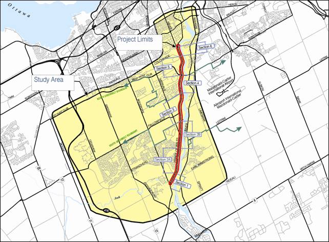
Figure 1 – Study Area and Project Limits


The characteristics of the Prince of Wales corridor vary significantly over its entire length. To assist with the evaluation of existing conditions and alternatives, the corridor was divided into the following sections, developed based on specific characteristics such as topography and land use:

·         Section 1 – Woodroffe Avenue to Strandherd Drive

·         Section 2 – Strandherd Drive to Southern Greenbelt Boundary further divided as:

            - Section 2A – Strandherd Drive to Crestway Drive

            - Section 2B – Crestway Drive to Southern Greenbelt Boundary

·         Section 3 – Greenbelt

·         Section 4 – Northern Greenbelt Boundary to West Hunt Club Road

·         Section 5 – West Hunt Club Road to Colonnade Road

·         Section 6 – Colonnade Road to Fisher Avenue


Although initially included as part of the Prince of Wales Drive EA Study, it was determined that the Woodroffe Avenue to Strandherd Drive (Section 1) portion of the corridor had already been identified for widening and the alignment established as part of the Strandherd Drive Extension (1997) EA Study.  Construction on this section of Prince of Wales Drive commenced in 2010 as part of the most easterly phase of the Strandherd Drive project, which is to be followed with a connection to the new Strandherd-Armstrong Bridge crossing of the Rideau River (currently underway).  Although Section 1 is no longer considered to be formally part of the Prince of Wales Drive EA Study due to its previous EA approval, its features are described for continuity with the remainder of the project. 


Need and Opportunity:


As stated previously, significant growth is occurring and is expected to continue in the SUA over the next 20 years. The forecast population and employment levels will result in higher levels of peak period trips on the transportation network.


Based on a review of transportation, land use and growth issues, the following summarizes key issues addressed by this study:

·         There is limited residual north-south arterial roadway capacity to serve the current and future needs of the South Urban Area, as well as communities beyond;

·         Increased transit use and the achievement of a city-wide 30 per cent transit modal share by 2031 does not eliminate the need for increased roadway capacity to address this deficiency (locally and community-wide);

·         There are currently no pedestrian and only partial cycling facilities along the Prince of Wales Drive corridor to serve current and future needs;

·         The type (full movement, partial movement, signalized or un-signalized) and location of accesses to adjacent side streets, current and proposed developments needed to be reviewed to allow for adequate and safe traffic operations meeting City’s guidelines;

·         The Scenic Route designation for Prince of Wales Drive, and the UNESCO World Heritage designation of the Rideau River and Canal system indicate a need to confirm, protect for and proceed with establishing an urban design vision to maintain, preserve and enhance these unique characteristics; and,

·         The potential downstream traffic impacts of the project needed to be assessed for the area immediately north of the study area.


Alternative Solutions:


Ten alternative solutions were identified and assessed in terms of their ability to address existing and future needs:


·         Do Nothing

·         Expand Public Transit

·         Expand/Enhance Pedestrian and Cycling Facilities

·         Implement Transportation System Management (TSM)

·         Demand Management/Ride Sharing

·         Expand other Roadways within the study area:

-          Highway 416

-          Merivale Road

-          Woodroffe Avenue

-          Greenbank Road (from Fallowfield Road to Hunt-Club Road)

·         Widen Prince of Wales Drive (over part or all of study corridor)


In summary, the study concluded that:

·         A ‘Do Nothing’ alternative does not accommodate future north-south travel demand within the study area.  Further it does not address the needs of pedestrians and cyclists within the Prince of Wales Drive corridor.

·          ‘Expansion of Public Transit’ is a vital element of the City’s strategy to accommodate future travel demand growth within the South Urban Area and, depending on location, is projected to carry increases in peak period person-trips of between approximately 100 and 150 per cent by 2031.  However, even assuming the realization of the City’s 2031 transit modal split targets (30 per cent city-wide), additional north-south roadway capacity will still be required to meet the projected 2031 travel demand.

·         Although all are important elements of the City’s overall transportation strategy, none of the ‘Expand/Enhance Pedestrian and Cycling Facilities,’ ‘Transportation System Management,’ ‘Demand Management/Ride Sharing’ alternatives were considered adequate stand-alone solutions to resolve the capacity deficiency along the Prince of Wales Drive corridor. Expansion/enhancement of pedestrian and cycling facilities are recommended as part of the overall solution.

·      The ‘Expand Other Roadways’ alternative does not address the transportation needs within the immediate study area:

-   ‘Widening of Highway 416’ through the Greenbelt to Baseline Road appears to be a viable option for additional north-south capacity. However analysis shows that the provision of additional capacity on this roadway would be unlikely to address the projected capacity problem along the Prince of Wales Drive corridor (at the Fallowfield and CNR Screenlines) given that Highway 416 is somewhat out of the way from the desired travel lines.

-   ‘Widening of Merivale Road’ was the subject of a separate EA study. However the Merivale Road/Fallowfield Road Class Environmental Assessment (July 2004) indicated the widening was only justified on the basis of the need to serve the surrounding communities including the South Merivale Business Park and concluded that widening Merivale Road through the Greenbelt is not preferred. Consequently, Merivale Road was discounted as an alternative for additional north-south capacity.

-   ‘Widening of Woodroffe Avenue’ has recently been implemented as a four-lane roadway south of Hunt Club Road between the Nepean Sportsplex and Fallowfield Road to alleviate the capacity deficiencies at the Fallowfield Screenline.  The planned closure of Woodroffe Avenue at Prince of Wales Drive (expected upon the extension of Strandherd Drive to Prince of Wales Drive) limits the ability to put further widening of Woodroffe Avenue to effective use. Woodroffe Avenue is not a viable alternative for roadway expansion.

-   Greenbank Road is currently a two-lane roadway at the Fallowfield Screenline and through the Greenbelt, expanding to four lanes just south of Hunt Club Road and across the CNR West Screenline.  Given that Greenbank Road is already a four-lane roadway across the CNR West Screenline, it is less suited to satisfy the requirement for one additional lane in each direction at this screenline.  In light of the above, ‘Widening of Greenbank Road’ is not a preferred alternative.

·         ‘Widening Prince of Wales Drive,’ despite some corridor constraints and anticipated project effects, is a viable alternative in that it serves a predominant north-south travel pattern of commuters from the South Urban Area who are destined to the City’s core or other central locations to the north.  It also provides direct access to the Strandherd-Armstrong Bridge, West Hunt Club Road, Hogs Back Road and Heron Road Crossings of the Rideau River as well as north-south commuter routes along Riverside Drive to the east, Fisher Avenue to the west, and Colonel By Drive to the north.

Right-of-way has been protected for many years along this corridor for a future widening, although it is recognized that property acquisition will still be required.  The corridor also lacks access control to numerous private properties and has in some sections, no pedestrian or pathway facilities.  It is still a rural highway with great potential for conversion into a more functional urban transportation facility for all modes of travel and one which better represents its scenic route status.


Identification of Alternative Designs:


The recommended design was selected based on a multi-criteria assessment of Alternative Design Concepts including:


·         Alignment Alternatives

·         Cross-Section Alternatives

·         Access/Intersection Alternatives

·         Multi-Use Pathway Alternatives

·         CN/VIA Rail Bridge Overpass Alternatives


For each section of the project, alignment options such as equal widening, widening to the west and to the east or in combination were considered. The development of roadway cross-section alternatives (16 in total) included the following factors:


·         Roadway classification and design guidelines and standards

·         Number of through lanes (e.g. 2, 3 or 4-lanes) and auxiliary lanes

·         Median treatments/extent of access control (property access)

·         Sidewalks, multi-use pathways, boulevards, planting zones

·         Noise attenuation

·         Illumination


Property access alternatives included:


·         Full movement access (undivided roadway)

·         Full movement access (median breaks or depressed median)

·         Full movement access (with intersection consolidation and local service road)

·         Right-in/right-out access


The following streets intersecting with Prince of Wales Drive were considered:


·         Lodge Road South

·         Fallowfield Road

·         Woodroffe Avenue

·         Black Rapids Locks

·         Carleton Lodge access

·         Amberwood Crescent

·         Rocky Hill Drive

·         Waterford Way

·         Lodge Road North

·         Blazer Avenue

·         Strandherd Drive

·         Deakin Street

·         Barnstone Drive

·         Waterbend Lane

·         Fairpark Drive

·         Hunt Club Road

·         Waterbridge Drive

·         Rideau Heights Drive

·         Winding Way

·         Wellsmere Court

·         Crestway Drive

·         Stephanie Avenue

·         Heathwoods Gate

·         Colonnade Road

·         Merivale Road

·         Rideau Shore Court

·         Holborn Avenue

·         Fisher Avenue

·         Rideau Glen Drive


The following traffic control alternatives were considered:


·         Traffic signals

·         Roundabout

·         Stop signs

·         Right-in/right-out

·         Cul-de-sac


Additionally, the following intersections were considered for realignment and/or consolidation where appropriate: Merivale Road/Holborn Avenue; Deakin Street/Waterbend Lane; and service roads in various locations. In addition, the West Hunt Club Road intersection was reviewed as it is the largest existing intersection within the study limits and is currently operating at or near capacity.


Intersection at West Hunt Club Road


Additional analysis was undertaken to examine the intersection at West Hunt Club Road to address the operating conditions at this location as well as the limited east-west traffic distribution opportunities across the Rideau River, both significant issues for this project.

Intersection alternatives that were considered included: grade-separated interchanges, roundabouts, and turning restrictions (for left turns) in conjunction with new roadway linkages and/or grade-separated ramps.

Of the above options, a fully grade-separated interchange or left-turn lane restrictions with diverted left-turn movements held the most potential to improve intersection operations.  Both of these options, however, would result in very significant property impacts and would have limited value on their own without similar significant changes to the area of Hunt Club Road at Riverside Drive to the east.  The investment in significant capital in major infrastructure such as interchanges on municipal roadways is counter to the City’s vision of sustainable transportation and of investing in transit first including, in the case of the South Urban Area, the planned expansion of rapid transit to serve both Barrhaven and Riverside South.

Modeling analysis of options at the roadway network level that could potentially alleviate the forecasted traffic volumes at the above intersection was also conducted.  The widening of Merivale Road from two to four lanes between Prince of Wales Drive and Slack Road provided relief at the Fallowfield screenline level but no relief to the intersection at Prince of Wales Drive and West Hunt Club Road.  The addition of a new Rideau River crossing would provide relief at the Rideau River Screenline but limited relief at the Prince of Wales Drive/West Hunt Club Road intersection.  The screenline analysis as well as the intersection operations analysis indicate that the analyzed network improvements provide only minimal positive impacts on the intersection.  With only minor modifications to its current configuration, it is acknowledged that the intersection will continue to operate at capacity.  Options to alleviate projected congestion at this location either come at a very high cost or provide limited benefit. 


In light of the above, it is recommended that operating conditions at the Prince of Wales Drive/West Hunt Club Road intersection area continue to be monitored with further assessment conducted as part of future TMP updates as well as through projects such as the proposed future six-laning of Hunt Club Road to further explore the above and other potential solutions.


Evaluation of Alternative Designs


The evaluation of Alternative Design Concepts (cross-section, alignment, and intersection alternatives) was based on a comparative analysis of environmental, engineering, and cost factors.  The following criteria were identified for inclusion in the evaluation of alternatives:


Natural

Environment


Socio-Economic Environment


Traffic and

Transportation


·         Fisheries and Aquatic Habitat

·         Vegetation

·         Wildlife Habitat and Mobility

·         Surface Water

·         Groundwater

·         Surface Geology and Soils

·         Air Quality

·         Noise and Vibration

·         Land Use

·         Property Ownership

·         Economy

·         Agricultural

·         Community/Recreation

·         Aesthetics

·         Road Network Continuity

·         Traffic and Operations

·         Cyclist/Pedestrian Accommodation

·         Safety

·         Access/Egress

·         Construction Staging

·         Emergency Vehicle Access


Cultural Environment


Cost


·         Heritage

·         Archaeological

·         Cultural Landscape

·         Life Cycle

·         Property

·         Utilities


Details on evaluation methodology are available in Document 3.


Recommended Plan


Upon completion of the assessment of alternative design concepts, a divided four-lane arterial cross-section with cycling facilities is proposed for Prince of Wales Drive, including a concrete sidewalk and/or an asphalt multi-use pathway, and a raised median with lighting. The treatment of the outer edges of the roadway varies from fully urban (curbed) to fully rural (paved shoulders for cyclist use and ditches) to a combination of both.  Landscaping is proposed along sections of the corridor at a conceptual level at this time, with details to be developed at detail design.


Design Criteria


Key design criteria for the recommended alternative include:


·         2.0 m on-road or segregated cycling lanes

·         3.5 m traffic lanes (3.75 m adjacent to a median)

·         5.0 m median (including provision for left-turn lanes at intersections)

·         2.0 m concrete sidewalks/3.0 m asphalt multi-use pathway

·         Design speeds:  vary from 70 km/h to 90 km/h

·         Posted speeds:  60 km/h from Woodroffe Avenue to Strandherd Drive; 70 km/h from north of Strandherd Drive to south of Greenbelt boundary; 80 km/h through Greenbelt; and 60 km/h north of the Greenbelt.


As a result, the following summarizes key features of the Recommended Plan for each section (Document 1).


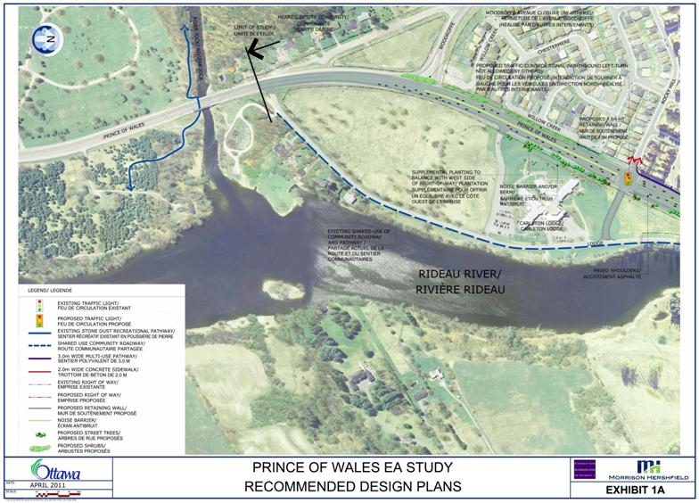
Section 1 – South of Woodroffe Avenue to Strandherd Drive - 1.2 km

(Document 1: Exhibits 1A, 1B)


This section was already addressed through the Strandherd Drive Extension EA Study (1997). The roadway features are described here for continuity with the remainder of the project.  It is a four-lane divided arterial (5.0 m median commencing at the location of the existing Woodroffe Avenue) with an urban (curbed) west edge and rural (paved shoulder and ditched) east edge.  A posted speed reduction from 80 km/h to 60 km/h is proposed.


On-road cyclists will be accommodated with a combination of a cycling lane (west side) and a paved shoulder (east side).  A multi-use pathway, which will ultimately extends to Fisher Avenue, is provided on the west side of the road from Rocky Hill Drive northerly.


The horizontal alignment of the road matches existing Prince of Wales Drive at the south end and gradually shifts to the west and away from the Rideau River at the new Strandherd Drive intersection.


Woodroffe Avenue will be closed at Prince of Wales Drive after the major new signalized intersection of Strandherd Drive at Prince of Wales Drive is constructed.  Rocky Hill Drive will be signalized and extended east of Prince of Wales Drive to Lodge Road.  Lodge Road (North) will be closed at Prince of Wales Drive due to its proximity to Strandherd Drive.  The primary Carleton Lodge access will be modified to right-in/right-out access.


A scenic lookout and trailhead/parking area are proposed at the existing northerly terminus of Lodge Road to provide access to the river and Chapman Mills Conservation Area trails to the north.


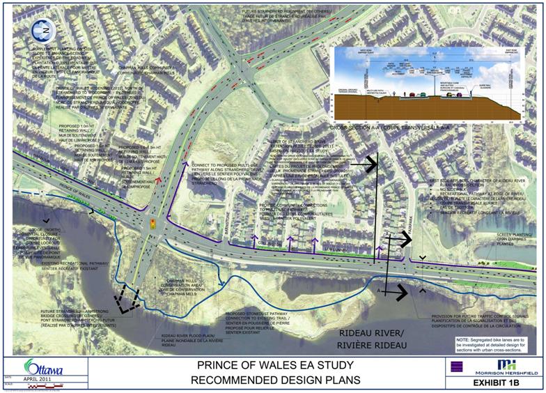
Section 2A – Strandherd Drive to Crestway Drive – 1.75 km

(Document 1: Exhibits 1B, 1C)


This section includes a combination of residential development along parts of each side of the corridor as well as an open space in the form of a long stretch of the Rideau River and the Chapman Mills Conservation Area on the east and the Strandherd Drive Stormwater Management Facility on the west.


The Recommended Plan is a four-lane divided arterial with an urban (curbed) west edge and rural east edge (paved shoulder, gutter and guide rail) between Barnstone Drive and Waterbridge Drive and an urban cross-section on both sides of Prince of Wales Drive between Waterbridge Drive and Crestway Drive.


On-road cyclists will be accommodated with a combination of a cycling lane (west side) and a paved shoulder (east side). A multi-use pathway is provided on the west side of the road.  New pedestrian linkages into the adjacent communities are proposed at Baypointe Crescent and at Tradewinds Drive grade differentials have been identified and will have to be addressed at detailed design.  Although no new pedestrian facilities are proposed along the east edge of the roadway a seasonal walking trail exists through the adjacent Chapman Mills Conservation Area.


The horizontal alignment of the road transitions from being shifted to the west of the existing roadway at Strandherd Drive to matching the existing centreline at Waterbridge Drive, north of which an approximately equal widening is proposed. 


Waterbridge Drive and Crestway Drive will retain traffic control signals and will be expanded with auxiliary turning lanes as shown on the plans.  Barnstone Drive will be restricted to right-in/right-out access.  Although Fairpark Drive is not currently recommended for traffic control signals, it is proposed that a provisional underground plant be provided, allowing for potential future traffic control signals if warranted.


One left side entrance (at the Strandherd Stormwater Management Facility) will be converted to right-in/right-out access.


This stretch of Prince of Wales Drive presents vistas of the Rideau River.  For this reason proposed landscaping is emphasized to a greater extent along the western side of the corridor to the south of Waterbridge Drive.


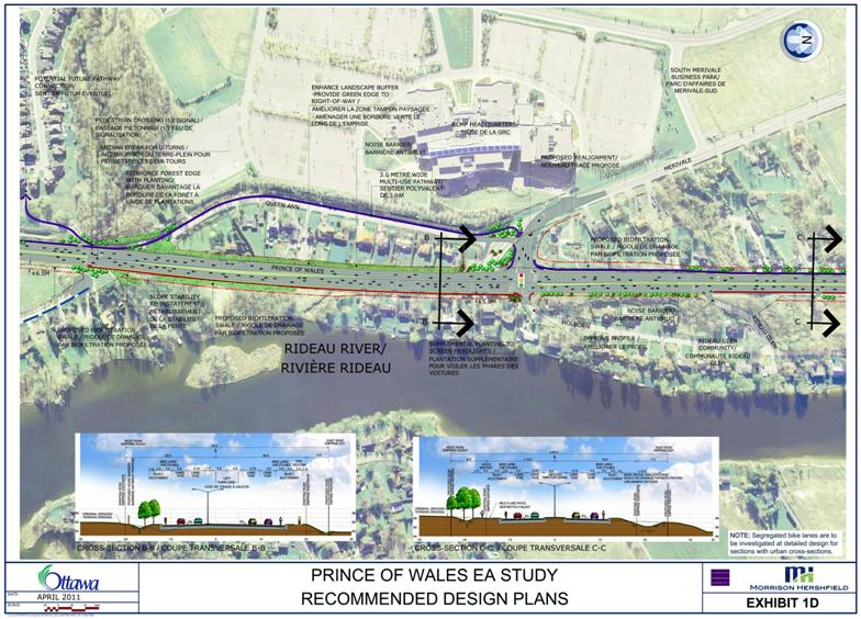
Section 2B – Crestway Drive to South Greenbelt Boundary – 2.0 km

(Document 1: Exhibits 1C, 1D, 1E)


This section includes a combination of both newer sub-division style and long-established direct frontage (and some backing) residential development along both sides of the corridor.  In addition there are some pockets of open space and greenspace (i.e. north of Crestway Drive; Sach’s Forest at the Clarke Bellinger Drain outlet; undeveloped lands immediately south of the Greenbelt).


The recommended plan is a four-lane divided arterial with generally a fully urban (curbed) cross‑section.


On-road cycling lanes are proposed. A multi-use pathway is proposed along the west side of the road which diverts to Queen Ann Crescent before returning to Prince of Wales Drive at Merivale Road.  A new sidewalk is recommended between the now closed north end of Winding Way and Holborn Avenue and from Rideau Glen Drive 400 m to the north – both on the east side of the corridor.  New multi-use pathway linkages into the adjacent community to the west are proposed just north of Crestway Drive and opposite the north end of Winding Way.  At the latter location, a pedestrian-activated traffic control signal is also proposed in recognition of the expected increased pedestrian and cyclist demand to cross Prince of Wales Drive at this location.


The horizontal alignment of the roadway follows an approximately equal widening through this section.


The existing intersection of Merivale Road is proposed to be shifted approximately 50 m to the north to realign with the existing Holborn Avenue as shown on Figure 2.  This would allow a signalized access for the Rideau Glen community.  The intersection of Rideau Glen Drive with Prince of Wales Drive is proposed to be changed to right-in/right-out access with the proviso that a bus turnaround be constructed at the end of Holborn Avenue.


1-Merivale-Holborn-RideauGlen_PoW-07Jun

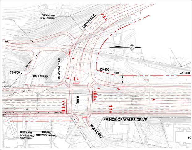
Figure 2 – Realignment of Merivale Road with Holborn Avenue


Improvements to the relatively steep vertical grades on both Holborn Avenue and Rideau Glen Drive are recommended on their approaches to Prince of Wales Drive.  A moderate lowering of the roadway profile is recommended to maintain acceptable east side laneway gradients on Prince of Wales Drive north of Rideau Glen Drive.


Forty-one existing entrances with existing full movement access onto Prince of Wales Drive will be converted to right-in/right-out access.  These include 23 residences.  Left-turn access to/from these properties will be accommodated through U-turns at nearby intersections or median breaks.


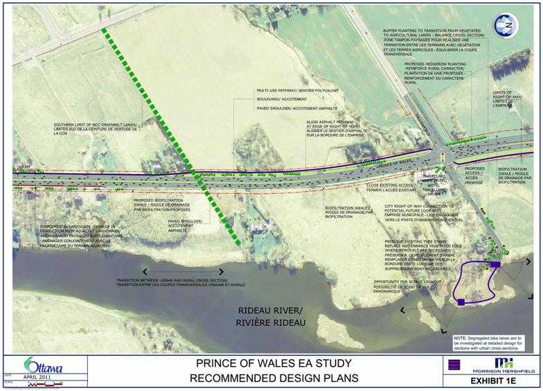
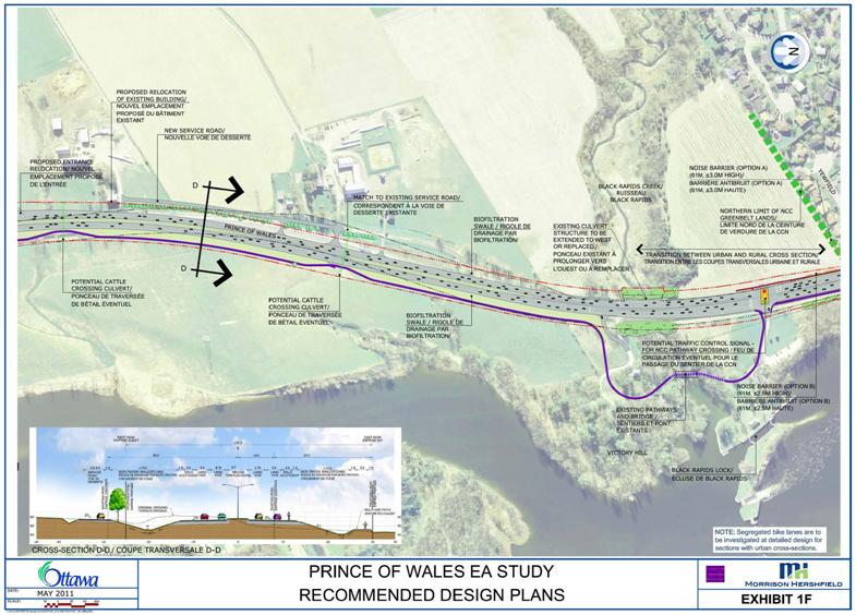
Section 3 – Greenbelt – 2.05 km (Document 1: Exhibits 1E, 1F)


This section includes primarily agricultural lands (including two of the three active dairy farms within the Greenbelt); the Black Rapids Creek valley and lock station; several residential properties (including some occupied by tenants of the NCC); and the Travellers Haven Motel at Fallowfield Road.


The Recommended Plan is a four-lane divided arterial with a rural (paved shoulders, ditched) cross-section. 


On-road cyclists will be accommodated on paved shoulders. A multi-use pathway is proposed along the west side of the road from the south limit of the Greenbelt to Fallowfield Road at which point it would shift to the east side of the road to avoid the agricultural entrances on the west side and to offer better views of the Rideau River and convenient access to the Black Rapids Creek locks.  A short pathway link is proposed to extend along the east side of Prince of Wales Drive from the access to the Black Rapids locks northward.  The NCC has plans for an east-west multi-use pathway along Black Rapids Creek - the final location of which may influence a potential traffic control signal that is being considered to enable users of the NCC pathway to safely cross Prince of Wales Drive. The alternate location for traffic control signals to support the NCC’s pathway would be just south of Black Rapids Creek at the existing or a realigned access to the area known as Victory Hill.  This location would support the provision of new traffic control signals at Amberwood Crescent. A final decision as to whether or not to accommodate this additional set of traffic control signals will be made at the detailed design stage of the project in consultation with the NCC regarding the Commission’s final pathway location plans.


The horizontal alignment of the widened road follows a varying alignment in relation to the existing road in an effort to limit potential encroachments on the Travellers Haven Motel, the northerly cluster of farm properties and the east side embankments in the vicinity of Black Rapids Creek.


The existing signalized intersection of Fallowfield Road will be modified to include additional turning lanes and the east leg of the intersection will be extended - providing access to the Travellers Haven Motel and a potential trailhead for a trail to the edge of the Rideau River as depicted on Figure 3. Due to significant grade restrictions, the Travellers Haven Motel will be reduced to a single entrance.
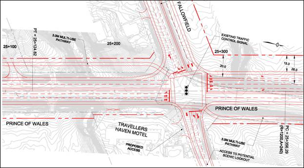
 

2-Followfield_PoW-TrevallersHavenMotel-07JunFigure 3 – Fallowfield Road Intersection Modification


Thirteen existing entrances with full movement access onto Prince of Wales Drive will be converted to right-in/right-out access.  These include three residences with the remainder being primarily field entrances.  Left-turn access to/from these properties will be accommodated through U-turns at nearby intersections or median breaks.  A short section of local service road (to be maintained by the NCC or its tenants) along the west side of Prince of Wales Drive is proposed to allow consolidation of four existing farm-related accesses (including the two dairy farms) into one entrance with a median break and northbound left-turn lane on Prince of Wales Drive. 


Locations for two potential cattle culvert crossings have been identified at the NCC’s request to enable safe and convenient movement of cattle to and from the pastures on the east side of the road.


The Greenbelt portion of the Prince of Wales Drive corridor affords excellent views of the Rideau River to the east; the two active dairy farms to the west; and, the historic lock station and locks at Black Rapids.


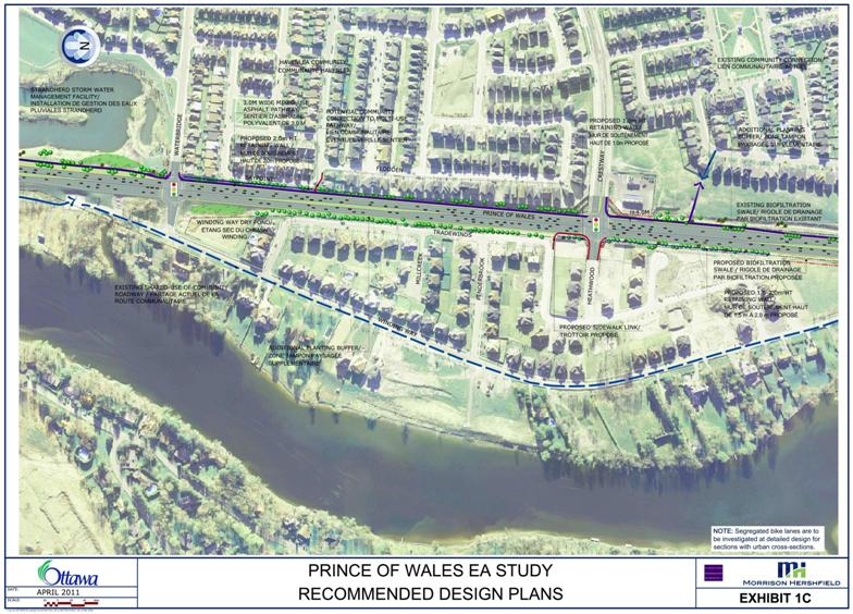
Section 4 – North Greenbelt Boundary to West Hunt Club Road – 1.4 km

(Document 1: Exhibits 1G, 1H)


This section includes a mix of residential development types, several businesses (Tim Horton’s, the Monterey Inn, and the New Highway Inn), undeveloped commercial properties, and the recently constructed Metropolitan Bible Church.


The Recommended Plan is a four-lane mostly divided arterial with a fully urban (curbed) cross‑section.


On-road cyclists will be accommodated with cycling lanes. A multi-use pathway is proposed along the east side of the roadway and a new sidewalk along the west side.


The horizontal alignment of the roadway mostly follows an approximately equal widening through this section, although some variation has been introduced to minimize impacts to property as shown on Figure 4.
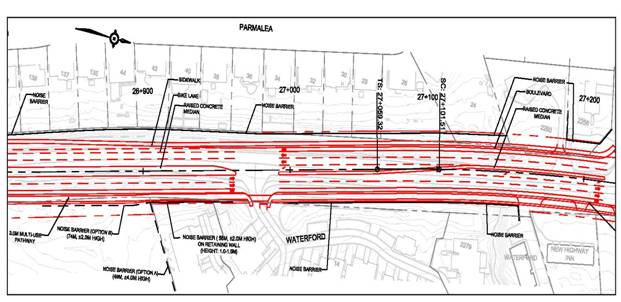


Figure 4 – Alignment for Prince of Wales Drive north of Amberwood Crescent


New traffic control signals are recommended at Amberwood Crescent.  Waterford Drive and Blazer Street are proposed to remain as unsignalized intersections, however, protected left-turn lanes will be provided onto these streets from Prince of Wales Drive.  Turning lane modifications are recommended to the existing intersections at Deakin Street and West Hunt Club Road.  A short section of two-way left-turn lane is proposed between Blazer Street and Deakin Street which will allow access to the Monterey Inn and three residences as depicted on Figure 5.


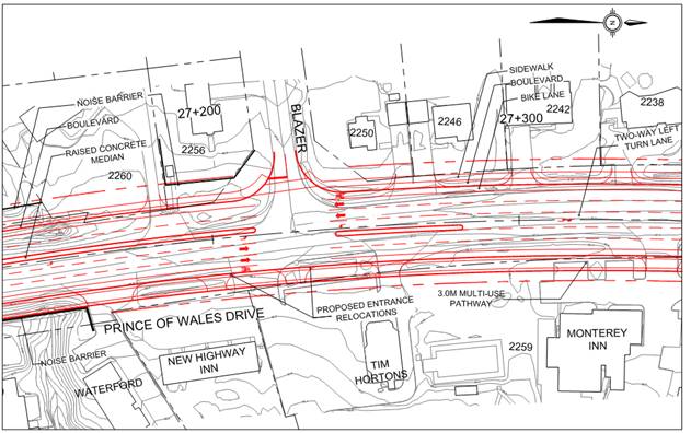
Figure 5 – Blazer Intersection and Property Accesses


Twenty three existing primarily residential entrances with full movement access onto Prince of Wales Drive, some of which are shown in Figure 6, will be converted to right-in/right-out access.  This includes the five homes on Waterbend Lane; the former ESSO gas station at West Hunt Club Road that has an existing left-turn in only access from Prince of Wales Drive; and, the existing fire lane exit from the Waterford residential development.  Left-turn access to/from these properties will be accommodated through U-turns at nearby intersections or median breaks.  Some of the properties will experience relatively significant (1 m to 6 m) property encroachments.

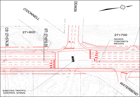
Figure 6 – Deakin Street and Waterbend Lane


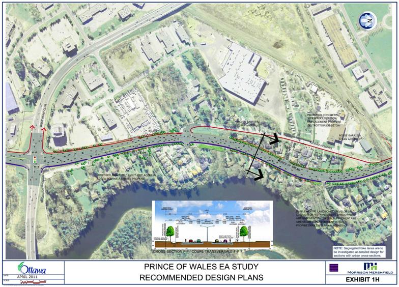
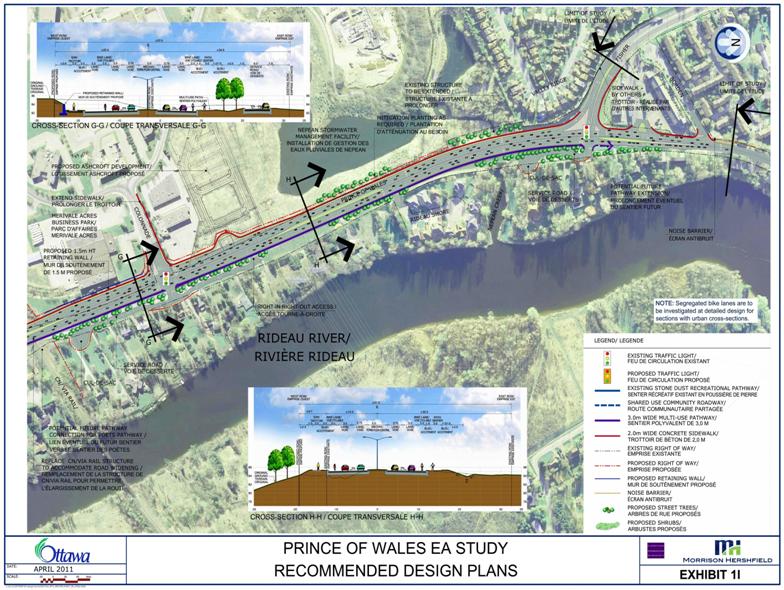
Section 5 – West Hunt Club Road to Colonnade Road – 1.3 km (Document 1: Exhibits 1H, 1I)


This section includes a mix of residential development types and several businesses on Prince of Wales Drive and Rideau Heights Drive.  Prince of Wales Drive has an underpass of the CN/VIA Rail line just south of Colonnade Road.


The recommended plan is a four-lane mostly divided arterial with a fully urban (curbed) cross‑section.


On-road cyclists will be accommodated with cycling lanes. A multi-use pathway is proposed along the east side of the roadway and a new sidewalk along the west side except where it diverts along Rideau Heights Drive to minimize property encroachments.


The horizontal alignment of the roadway mostly follows an equal widening, although a shift to the west is introduced at the north end to improve construction staging flexibility at the rail underpass and to enable the inclusion of an east side local service road north of the rail line.


The existing CN/VIA Rail structure will be replaced with a new two-span structure. A temporary rail diversion to the north is proposed as shown on Figure 7. Provision for a walkway on the north side of the rail embankment east of the new structure has been proposed to allow for a possible future east-west pedestrian linkage as part of the Poets Pathway proposal.

CNRail_exhibit-CNR OPT1

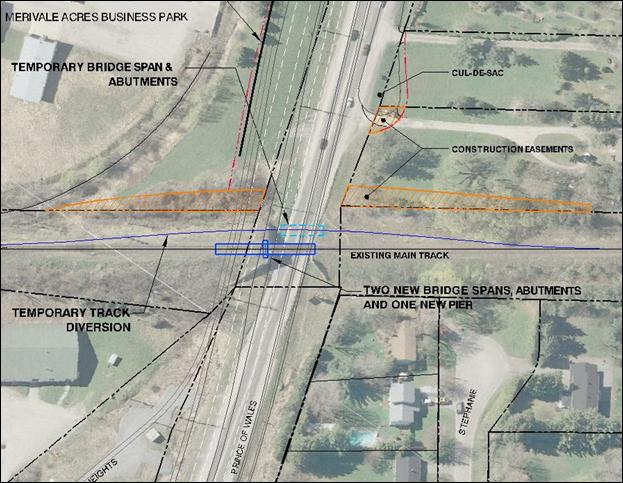
Figure 7 – Proposed Railway Bridge Overpass Diversion


Rideau Heights Drive/Wellsmere Court, Rideau Heights Lane and Stephanie Avenue are proposed to remain as unsignalized intersections, however, protected left-turn lanes will be provided into these streets from Prince of Wales Drive.  Modifications are recommended to the existing signalized intersection at Colonnade Road including the addition of a new east leg to the intersection to accommodate the connection for the proposed local service road.


Twenty three existing entrances with full movement access onto Prince of Wales Drive will be converted to right-in/right-out access. These include three commercial properties and various residences - including four on the existing cul-de-sac lane immediately north of Hunt Club Road.  Left-turn access to/from these properties will be accommodated through U-turns at nearby intersections or median breaks.  Five properties will benefit from the proposed service road connection to Colonnade Road.


Several residential properties will experience 5 m to 6 m property encroachments.  One residential property will experience a significant property encroachment (23 m) due to the westerly shift of the roadway north of the CN/VIA Rail line.


Section 6 – Colonnade Road to North of Fisher Avenue – 1.0 km (Document 1: Exhibit 1 I)


This section includes residential development; commercial properties off of Colonnade Road and at Fisher Avenue; the Nepean Creek Stormwater Management facility; and major overhead Hydro One power lines.


The Recommended Plan is a four-lane divided arterial with a fully urban (curbed) cross-section.


On-road cyclists will be accommodated with cycling lanes. A multi-use pathway is proposed along the east side of the roadway and a new sidewalk along the west side.  Future consideration should be made to extending the east side pathway north of Fisher Avenue to allow connectivity with existing pathways at Hogs Back Road and Colonel By Drive.


The horizontal alignment of the roadway transitions from a westerly shifted alignment at Colonnade Road to an equal widening at Fisher Avenue.


Rideau Shore Court is proposed to remain as an unsignalized intersection with a new protected southbound left turn lane.  Modifications are recommended to the existing intersection at Fisher Avenue including a double left-turn lane and the addition of a new east leg to the intersection to accommodate the connection for a proposed short section of local service road as shown on Figure 8.


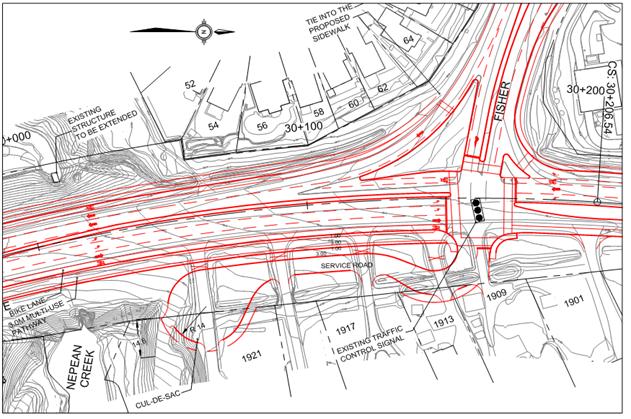
Figure 8 – Service Road and Fisher Avenue Intersection Modification


Ten existing entrances with full movement access onto Prince of Wales Drive will be converted to right-in/right-out access.  These include the gas station/plaza entrance at Fisher Avenue, seven residences and an access to the Nepean Creek Stormwater Management Pond.  Left-turn access to/from these properties will be accommodated through U-turns at nearby intersections or median breaks.  Twelve properties will benefit from the full movement access afforded by two new local service roads connecting at Colonnade Road and Fisher Avenue.


Some of the properties will experience relatively significant property encroachments (up to 18 m) due to the westerly shift of the roadway. 


Segregated Bike Lanes


Although on-road cycling lanes are shown in the plan it is also proposed that segregated bike lanes be investigated at detailed design stage for sections with an identified bike lane and an urban cross-section. This will enhance the safety for cyclists.


Traffic Impacts to the North of the Study Area


It is proposed that the two northbound lanes in Section 6, transition into one northbound through lane on Prince of Wales Drive north Fisher Avenue and double-left turn lanes from Prince of Wales Drive onto Fisher Avenue northbound.  This corresponds with the current roadway geometry north and west of the Fisher Avenue/Prince of Wales Drive intersection. It is also in‑line with projected future travel patterns which indicate that the strongest desire line north of the project limits will be via Fisher Avenue. Fisher Avenue has the capacity to carry 65% of the projected traffic growth, where Prince of Wales will only accomodate 35%. The 2031 morning peak hour, peak direction travel pattern  is depicted in Figure 9.


Figure 3

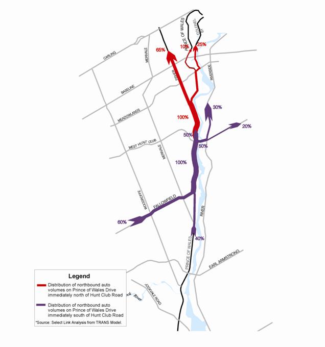
Figure 9 - 2031 Morning peak Hour – Peak Direction Travel Patterns


The proposed plan for Section 6 is also in keeping with the results from the Carleton Heights Traffic Area Management Study. This Traffic Study recommended that provisions for traffic calming measures be made in addition to sidewalks along Prince of Wales Drive north of Fisher Avenue.


Although intersections north of the project at Fisher Avenue/Meadowlands Drive and at Prince of Wales Drive/Meadowlands Drive are projected to operate at acceptable levels of service, a potential capacity deficiency has been identified north of Baseline Road.


As a result of the above and in recognition of concerns within the Carleton Heights community regarding increased traffic pressures, it is proposed that:


·         The widening of Prince of Wales Drive be implemented from south to north.

·         Preliminary construction phasing be coordinated with other TMP projects in the area (with priority given to transit), as described in Table 1.

·         Assessment of need for potential widening of Fisher Avenue (Dynes Road to Carling Avenue) be considered in the next TMP update.

·         Implement mitigation strategies outlined in the Carleton Heights Area Traffic Management Study as appropriate (http://www.ottawa.ca/calendar/ottawa/citycouncil/trc/2009/12-02/ACS2009-ICS-PGM-0226.htm).


Table 1 – Preliminary Construction Phasing

Timing for Implementation

Prince of Wales Widening from 2 to 4 lanes

Other Supporting Projects


Under construction in 2010

·      From Woodroffe to Strandherd ( 1.7 km)

·         Southwest Transitway extension from Fallowfield to Barrhaven Town Centre

·         Strandherd widening from Woodroffe to Limebank (including Strandherd-Armstrong River Crossing)

·         Limebank widening from Earl Armstrong to Riverside

·         Riverside Widening from Limebank to Hunt Club


Phase 2 of TMP (2016-2022)

·      From Strandherd to Merivale ( 2.3 km)

·      Hunt Club Road intersection modifications


Phase 3 of TMP
(2023-2031)

·      From Merivale to Hunt Club  ( 4.2 km)


·      Re- examine options to relieve the intersections at both approaches to the Hunt Club Rideau River Crossing

·      Hunt Club widening from Hwy. 416 to Bank Street

·      Fallowfield Road widening from
Woodroffe to Prince of Wales


·    Railway overpass reconstruction

·    From Hunt Club to Fisher (2.2 km)

·         Barnsdale widening from Prince of Wales to Hwy. 416

·         Alta Vista Parkway


ENVIRONMENTAL IMPLICATIONS


This section highlights key environmental implications resulting from the widening of Prince of Wales Drive. The complete summary with mitigation measures is available in Document 4.


Natural Environment


The existing Prince of Wales Drive corridor is generally disturbed from an ecological features and functions perspective, by extensive and expanding urbanization.  The majority of the corridor is cleared of woody vegetation and grassed where existing infrastructure is not present.  Adjacent land is typically urban residential and commercial, with agricultural lands in the Greenbelt.  However, there are a few greenspace corridors, generally associated with the Rideau River and the nine larger Rideau River tributaries, such as Nepean Creek, Black Rapids Creeks, and the Rideau Glen Tributary. These are identified as having the highest quality fish habitat in terms of diversity and density.


One designated natural area - Black Rapids (Life Science Site) 53.3 hectares - falls within the project limitsIt is recognized as having ecological features and is identified by the City as being ecologically important. 


Within the overall site, Parks Canada maintains a small public area to the west of the Rideau River that falls within the project limits.  There are no identified “Areas of Natural and Scientific Interest (ANSI)” or provincially significant wetlands within the project limits.


There are two Urban Natural Areas (UNA’s) within the vicinity of the project limits that were identified in the City of Ottawa’s Urban Natural Areas Environmental Evaluation Study (March 2005).  They are: the Nepean Creek corridor (south of Fisher Avenue) and the Strandherd Tributary (south of Crestway Drive).  Neither is listed as having high environmental significance.


The Rideau Valley Conservation Authority has ownership of the Chapman Mills Conservation Area located between Prince of Wales Drive and the Rideau River, south of Winding Way, and north of Lodge Road.  It consists mainly of natural river shoreline, wetlands, and flood plain areas and provides approximately 1.5 km of recreational trails through 23 acres of land.


During the construction phase, fish passage and spawning areas could be affected due to the replacement/extension of culverts (and other related activities), particularly in the areas in and around Nepean Creek, Black Rapids Creek, and the Rideau Glen Tributary. Therefore, all in-water works should be completed between July 1 and September 15 and must be completed outside of the more sensitive period for spawning and rearing of March 15 to June 30.  All culvert replacements/extensions are to be embedded 10 to 20 per cent.  Best management practices and stormwater management will help ensure no changes in the quality or quantity of surface or groundwater inputs to the watercourses.


Erosion and sediment controls are to be introduced during construction to reduce sediment loading as much as possible.  This includes:


It is anticipated that, following the implementation of the mitigation measures, the residual effects will be insignificant.


Wildlife/Species at Risk


A breeding bird survey was undertaken in June 2008.  No nationally or provincially significant wildlife species were observed during the field surveys or were reported for the general area.  The Nepean Creek and Black Rapids Creek corridors exhibited greater wildlife activity than any other area within the project limits.


No federal, provincial, or regional species at risk were found within the study area.


Surface Water


The study area is located within the Rideau River watershed. The UNESCO designated World Heritage Rideau River/Canal is located east of Prince of Wales Drive and flows in a north-easterly direction. The Rideau River primarily serves recreational functions including fishing and boating and attracts many people to the parks, beaches, historic sites, and conservation areas along its banks. This EA study aims at preserving/promoting these functions and the unique character of the Rideau River watershed.


Storm Water Management


Increased surface runoff is accounted for in the stormwater management plan.  The recommended approach is to direct initial volumes of runoff to either an existing stormwater management facility (Nepean SWM facility or the Strandherd SWM facility) or a biofiltration swale. In some areas, there are no available facilities and limited opportunity to provide biofiltration swales.  In this instance, oil and grit separators are recommended to be constructed in the storm sewer system to provide sediment and oil/grease removal prior to discharge.


The majority of the 30 culverts within the project limits are to be replaced or consolidated to provide an optimal number of culverts while respecting the existing drainage patterns.


It is anticipated that the residual effects will be insignificant following the implementation of these mitigation measures.


Soils/Contamination


A preliminary Geotechnical Assessment indicates that most of the area within the project limits is underlain by deposits of silt and clay of marine origin (commonly referred to as Leda Clay).  Fluvial deposits composed of medium grained sand are found along the west side of Prince of Wales Drive between Amberwood Crescent and the CN/VIA Rail Overpass.  Shallow glacial till deposits are located at the surface east and west of the roadway near the Strandherd Drive extension.


Drift thickness maps indicate that the overburden along the corridor is highly variable, and typically ranges from 5 m to 50 m, the thickest area being at the north and south ends of the project limits (an exception is at Black Rapids site as it has shallow bedrock). Limits of Hazard Land areas have also been identified in consultation with the Rideau Valley Conservation Authority and Parks Canada. These limits can affect roadway setback requirements from rivers or streams and, in this case, slope protection requirements. This will be considered in more detail at the design stage.


Air Quality


Fifty air quality receptors were modelled along the study corridor in an effort to gauge the existing pollution levels. Although areas near signalized intersections had the poorest air quality levels, in particular around the intersection of Prince of Wales Drive and Hunt Club Road, the levels are still significantly below the MOE recommended allowable limits.


Future air quality levels for a widened Prince of Wales Drive are still projected to be well below the MOE recommended allowable limits.


Noise


Fifty-three noise receptors were placed along the study corridor, including one east of the Rideau River, in an effort to gauge the existing noise level conditions.  Out of the 53 receptors, 28 were found to have existing daytime noise levels that were on average higher than the acceptable noise level of 55 dBA (14 were higher than 60 dBA).  The highest noise levels were recorded in close proximity to Prince of Wales Drive due to high traffic volumes and the absence of any significant noise barrier.  Lower levels were recorded where there was a greater separation between a property and the road/vehicular traffic and/or existing noise attenuation in place.


The widening of Prince of Wales Drive and increased traffic volumes will result in projected future noise levels increasing in some areas by either:


·         a significant amount (>3 dBA) and to a level in excess of the target maximum threshold of 55 dBA (but not more than 60 dBA); or

·         beyond the maximum absolute weighted daytime average noise level of 60 dBA as indicated in the City of Ottawa’s Noise Guidelines.


Mitigation for these areas was assessed on a site-by-site basis. Noise attenuation was recommended for those areas where a minimum reduction of 6 dBA in noise levels could be achieved.  The following areas shown in Table 2 were recommended for noise attenuation:


Table 2 - Recommended Noise Barrier Locations and Heights


Location

Required Barrier Heights

1.       

Northwest corner of Borden Side Road and Prince of Wales Drive – Townhouse units backing onto Prince of Wales Drive

3.0 m barrier comprising 0.6m berm and a 2.4 m barrier

2.       

West side of Prince of Wales Drive – North and South of Rideau Heights Lane – Homes Backing onto Prince of Wales Drive

3.0 m barrier comprising 0.6 m berm and a 2.4 m barrier

3.       

Houses along Amberwood Crescent and Parmalea Crescent that back onto Prince of Wales Drive (including 2256 Prince of Wales Drive)

Up to 4.5 m barrier comprising a 2.0 m berm and 2.5 m barrier

4.       

North and South ends of Waterford development – Homes along Prince of Wales Drive

1.5 m barrier comprising a wall and/or a berm

5.       

South end of Waterford development facing Greenbelt

Up to 4.0 m barrier

6.       

South side of Yewfield Court and Amberwood Crescent – Homes backing onto Prince of Wales Drive and facing south at Greenbelt

3.0 m barrier

7.       

West side of Holborn Avenue – Homes backing onto Prince of Wales Drive (between Holborn Avenue and Rideau Glen Drive)

2.5 m barrier comprising of a wall and/or a berm

8.       

Houses along Queen Ann Crescent that back onto Prince of Wales Drive

3.5 m barrier comprising of a 1.1 m berm and a 2.5 m barrier

Note: The above barrier heights are relative to roadway centreline and are subject to further review and refinement at detail design.


Vibration


Based on the measured vibration levels, vibrations from road traffic are moderately perceptible at a distance of 20 m to 30 m from the centerline of the roadway at many locations.  However, given that vibration levels measured close to the road were far below the level at which cosmetic damage to building finishes may occur and were generally less than the accepted annoyance threshold for continuous peak vibrations, it is anticipated that future ground vibration levels will not increase substantially to cause significant annoyance or structural issues during or after the widening of Prince of Wales Drive.


Archaeology


A Stage I Archaeology Assessment was carried out in December 2007.  It concluded that the presence of historic roads, the Jock River, the Rideau Canal, and several small-stream courses indicated the potential for Aboriginal and Euro-Canadian archaeological sites. A Stage II Archaeological Assessment is recommended to be undertaken at various undisturbed locations, including in the vicinity of the Black Rapids Locks Station within the Greenbelt, at the time of detail design.


Private Wells and Septic Services


There are approximately 80 to 100 properties, mostly residential, along the Prince of Wales Drive corridor, which currently have private well and/or septic bed systems.  A preliminary investigation estimates that up to 60 properties have a moderate to high potential for impact to their existing well and/or septic system as a result of the roadway widening.  These are generally located from south of Merivale Road to the South Greenbelt Boundary (35), within the Greenbelt (5) and from north of Amberwood Drive to Fisher Avenue (20).  Most properties north of Amberwood Drive have existing municipal water and/or sanitary services adjacent to them even if they are not all currently connected.


Nine of these properties are already included in the on-going Rideau Glen Local Improvement Project which involves the connection of these properties to a new municipal sanitary sewer at the cost of the property owner, to be implemented in 2011.  Twenty-two properties (including the nine noted above for new watermain only) located in proximity to the Rideau Glen Local Improvement Project (i.e. south of Holborn Avenue) may be serviced with new municipal watermain or sanitary sewer as a result of the roadway widening at the time of implementation.


While some affected properties can be connected to existing municipal services located along Prince of Wales Drive, the EA has identified that up to 35 properties located from south of Merivale Road to the south Greenbelt boundary will require a significant extension of services (up to 1.3 km).  Extension of municipal sanitary sewer services over short sections from north of Hunt Club Road toward Rideau Heights Drive (200 m) and from south of Rideau Heights Lane to south of Colonnade Road (500 m), or connections to existing adjacent water or sanitary services, will be required for up to about 20 properties for the area north of Amberwood Drive.


Five potentially affected properties within the Greenbelt may be too far away from existing or potential future servicing extensions and would require an assessment of on-site options to modify or replace existing well or septic systems as an alternative.


Property Impacts


The City’s Official Plan designates the protection of a 40 m right-of-way for Prince of Wales Drive within the project limits (except for the Greenbelt area).


Right-of-way requirements for the project vary from approximately 40 m to 55 m in some areas depending on roadway cross-section, topography, etc.  The City currently owns rights-of-way along the Prince of Wales Drive corridor ranging from approximately 30 m to 60 m with an ‘average’ existing right-of-way of between 35 m and 40 m.


The Greenbelt section of the project has a unique right-of-way protection policy designation of “G” for Greenbelt - indicating that a right-of-way protection policy is to apply which is to consider the number and width of travel lanes, the treatment of curbs, medians, and road drainage; and other amenities to be provided in the corridor.  The right-of-way to be acquired by the City is to be determined with involvement of the NCC on a case-by-case basis as road modifications are being planned.


The widening of Prince of Wales Drive will result in relatively significant property impacts over some sections of the corridor.  There are 127 properties from which land will have to be acquired with several at risk of having to be bought out completely (to be the subject of further review at detail design). 


The affected land owners are mostly private (residential, business, institutional).  However, lands are also required from the NCC (3.85 hectares), Transport Canada (0.12 hectares) and the Ministry of Transportation (0.13 hectares).


RURAL IMPLICATIONS


The project falls within the Urban Policy Plan area identified within the Official Plan.


CONSULTATION


The consultation program involved over 40 stakeholder groups, including community organizations, property owners and businesses within the study area, institutions, approval agencies and other groups with a special interest in the study.  In addition to the five Agency, and five Public Consultation Group meetings, three Public Open Houses were conducted in June 2008, February 2009 and April 2010 (the last of which included a presentation and question period).  More than 420 people attended in total.  The City has received over 90 comments from the open houses which supplements approximately 200 comments on the project that have been received to-date in the form of written submissions or email.


Individual meetings were also arranged with groups such as the Carleton Lodge, Waterford Community Association, Travellers Haven Motel, Tim Hortons, Monterey Inn, Metropolitan Bible Church, New Highway Inn, Rideau Heights Inn, private property owners, National Capital Commission, Parks Canada, Rideau Valley Conservation Authority and VIA Rail. Site visits with Rideau Glen Community Association and Waterford Community Association were also undertaken. Additional meetings with Councillor, community groups and landowners were also undertaken at the Councillor’s request.


Additionally, a specific consultation survey on potential parallel service roads was undertaken with affected homeowners (by mail). A specific consultation on existing wells and septic services including 10 site visits was also carried out.


Summaries of the three Public Open-House events are provided in Document 2.


Issues Arising From Consultations


The following summarizes the main consultation feed-back issues and how they were addressed:


·         Downstream Traffic Impacts north of Fisher Avenue -  As with any major arterial link in the City’s transportation network, Prince of Wales Drive is expected to carry traffic travelling between a broad array of origins and destinations - including trips within and beyond the limits of the study area.  A review of the transportation network north of Fisher Avenue will be undertaken as part of the next TMP update to reassess the capacity at the Baseline screenline, including the potential effects on Fisher Avenue.


·         Increase in Noise Levels and Noise Attenuation - Residents adjacent to Prince of Wales Drive were concerned with the forecasted increase in noise as some areas have existing noise level conditions that exceed the City’s recommended levels.  Seven noise attenuation measures (barrier, berm, or a combination) were initially recommended along the corridor for those areas where noise levels could be mitigated by at least 6 dBA.  After further on-site consultation with community association representatives and further study of the corridor, several additional locations were recommended for noise attenuation. 


In addition, residents of Waterford and Country Place (located in Section 4 of the Plan) have serious concerns about the wrap-around portion of the noise fence as recommended by the study.  Waterford properties that back onto federal lands have shallow back yards and residents don’t want the noise fence to obstruct their view of the open space and Black Rapids.  Similar concerns were heard from residents of Country Place (west side of Prince of Wales) with properties that back onto federal farmland.  Both groups have requested that the wrap-around portion of the noise fence be extended along Prince of Wales instead.  Residents are also aware of the Scenic Route designation of this corridor and have proposed that transparent noise walls be installed through the open area, allowing for vistas of the Unesco World Heritage designated Rideau River/Canal system to be preserved.


Recognizing the unique characteristics of the corridor and having experience in dealing with the NCC on matters pertaining to the protection of vistas on other projects with natural settings, and based on preliminary discussions with NCC staff on this specific matter, the wrap-around solution is proposed.  However, residents concerns are valid and their proposal merits reconsideration and therefore both options are recommended through this study and are shown on the Recommended Plan.


Option A (the wrap-around) for Waterford is 49 m in length and approximately 4.0 m in height (berm and wall) due to the significant grade difference between the road and the residential properties.  The wrap-around noise fence for Country place is 61 m in length, and 3.0 m in height. Option A has an estimate of $285,000 for a wooden noise fence.


Option B (extension along Prince of Wales), would have lengths of 74 m and 61 m, south of the property lines of Waterford and Country Place with approximate heights of 2.0 m and 2.5 m, respectively.  A transparent noise wall would have a ballpark estimate of $350,000 plus long-term maintenance expenses.


Through further work on the federal EA process, discussions with the NCC pertaining to noise wall placement, type of wall material, and policies regarding federal lands will continue, as too will engagement with residents in an effort to finalize the location of the noise walls following the filing of the Environmental Study Report.


·         Increase in Vibration Levels - Vibration levels were a noted concern for residents who live in close proximity to the roadway.  Future vibration levels were predicted to remain within an acceptable range, even after widening.  To ensure that vibration levels do not cause any property damage, monitoring will be done pre- and post-construction.


·         Reduction in Speed Limit - Consultation resulted in a proposed reduction in speed limits south of the Greenbelt to 70 km/h. Sidewalks, multi-use pathways, and dedicated bike lanes are being introduced, as well as an urban cross-section north of the Greenbelt, which may also aid in reducing excessive speeds.


·         Accesses to Properties Adjacent to Prince of Wales Drive - Modifications have been made to property and commercial accesses due to the roadway widening and the implementation of a 5.0 m raised median.  These modifications have been previously described in the report and include: right-in/right-out accesses where a median break is deemed unsafe; service roads (three to be introduced in the section north of Hunt-Club Road); designing for safe U-turns for residents; and, introducing signalized intersections where warranted.  Recommendations have also been made to lower the Prince of Wales Drive profile - north of Rideau Glen Drive and north of Amberwood Crescent to improve entrance gradients.


·         Alignment and Property Requirements - The alignment was developed to have the least affect on properties throughout the corridor (public and private lands). However, due to the right-of-way requirements of approximately 40 m to 55 m in some cases, depending on the roadway cross section and topography, property acquisition is unavoidable.  Many landowners including residents, businesses, and institutions as well as the NCC have indicated concerns regarding property impacts. These concerns include: affects on wells and septic, decrease in property value, loss of trees and landscaping, loss of farmland and in some cases, the ability to enter into agreement with the City to sell their entire property. Some residents have also suggest a relaxing of the design standards or removal of some roadway elements (such as sidewalks) in order to have no impact on residential properties.  The current Recommended Plan respects all Council-approved policies and the roadway design has been adjusted (for example, the removal of boulevards in a few locations) to minimize property impacts, while also ensuring safe operation in the corridor.  Overall, many of the concerns expressed along the corridor have been mitigated to some extent and will be further investigated during detailed design based on detailed property-by-property design reviews.


·         Soil Type/Presence of Leda Clay - Residents along Prince of Wales Drive, in particular those adjacent to the Rideau River are concerned with the potential increased risk of landslide and resulting property damage as Prince of Wales Drive is widened. The preliminary geotechnical assessment has already identified existing soil types along with limits of Hazard Lands. Mitigation measures (i.e. toe of slope erosion control, slope flatting, and, slope reinforcement) are recommended where the roadway widening falls within the limits of identified Hazard Lands.


·         Enhancement of the “Scenic Entry Route” - Prince of Wales Drive is a designated Scenic-Entry Route according to the City’s Official Plan. The NCC has also designated the route as a “Capital Arrival Route - a route through the Greenbelt that will enhance the visitors’ experience when they enter the Capital region”.  Although the character of Prince of Wales Drive will change as a result of widening to four lanes, there are measures to preserve/enhance the corridor aesthetics and function as a Scenic Entry Route.  Examples include retaining a rural design through the Greenbelt and a rural edge along the Rideau River, extending Fallowfield Road to the east for a new Scenic Lookout, implementing a north-south multi-use pathway along the entire length of the corridor, and closing Lodge Road’s north access to create a potential Scenic Lookout. Landscaping is also proposed at various locations within the Study corridor as well as context appropriate visual screening between adjacent residences and the roadway.


·         Consultation with CN/VIA Rail - Various bridge overpass reconstruction alternatives were discussed with VIA Rail to ensure their design and operational standards were met. Although meetings could not be arranged with CN Rail, regular correspondence occurred with CN Rail representatives over the course of the study. Consultation with VIA Rail resulted in a proposed construction staging approach, a temporary diversion of the bridge overpass to the north (as shown on Figure 7). This approach is to be further discussed at preliminary design stage with both CN and VIA Rail in conjunction with further geotechnical investigations.


COMMENTS BY THE WARD COUNCILLOR(S)


Councillor McRae is aware of the staff report and recommendations.  Prior to Phase 2 construction, Councillor McRae would like to ensure that the recommendations outlined in the Carleton Heights Area Traffic Management Study, approved by City Council on December 9, 2009, are implemented.  The recommended mitigation measures include the following:


Pedestrian Facilities/Sidewalks

·         Normandy Crescent (N) from Fisher Avenue to Prince of Wales Drive

·         Normandy Crescent (S) from Prince of Wales Drive to Apeldoorn Avenue

·         Apeldoorn Avenue from Falaise Road to Normandy Crescent (S)

·         Prince of Wales Drive, east side between approximately 30 metres south of Nesbitt Place and Melfa Crescent (South)


Pavement Markings Along Prince of Wales Drive

Delineate, via line painting and hatching, intersection narrowings to the immediate north and south of each of the following roads where they intersect with Prince of Wales Drive:

·         Melfa Crescent N

·         Melfa Crescent S

·         Normandy Crescent N

·         Two private road accesses between Kochar Drive and Melfa Crescent S


Further, Councillor McRae would like the multi-use pathway extended north of Fisher Avenue to connect to the existing pathways at Hogs Back Road and Colonel By Drive.


Comments from Councillor Keith Egli:

There are a number of issues that impact on Ward 9 arising out of the above referenced report. Two issues stand head and shoulders above the rest. These comments will focus on these two primary concerns.


1.                  Firstly there is the legitimate concern of residents of the Waterford, Glens and Country Place communities as to why the widening cannot be accommodated within the existing right of way.


The current proposal requires the expropriation of residents’ property while appearing to leave significant portions of unused right of way on the part of Prince of Wales running through the above mentioned communities. Up until very recently, despite significant involvement of the impacted communities, staff maintained that the current proposal was as a result of alignment/safety concerns. At a meeting held on May 13th 2011 it was disclosed that in fact the right of way was going to be used for the purpose of ditches. This was new information that the community had not been previously aware of. It is difficult to discern whether safety or ditches is the issue or whether there is in fact an issue at all. To the staff’s credit the latest draft of the EA report flags these issues but still recommends a design that will have a significant impact on residents’ enjoyment of their property and also the value of these properties.


It is therefore requested that a design that further minimizes the impact on residents’ property be given priority as opposed to the current proposal. The issues of the need for ditches, a multipurpose pathway, and a sidewalk that the communities contend will not be used due to the increased traffic that will be caused by the widening, need to be considered carefully prior to making the decision to expropriate the land in question.


2.                  The second issue has to do with the necessity and placement of noise barriers. Initially, staff was not prepared to place noise barriers in all locations that were requested by residents. This issue impacts primarily on the residents of Waterford and Country Place. The community was able to make a compelling argument for placing more noise barriers and staff, after review, concurred. Staff is to be commended for recognizing this need and attempting to address it. However, the current report points to two options for addressing the noise concerns. One, being Option A, would require the placement of a “noise fence” one metre from the balconies/back porches of Waterford residents. The proposed barrier would be approximately 15 feet in height. This approach would effectively take away any view from a community that has no backyards. It would also negatively impact the value of homes in Waterford which is known for its waterfront view. It would also impact negatively on the enjoyment of property by the affected Country Place residents and impact significantly on their view.


The city staff, until the earlier referenced May 13th meeting, maintained that Option A was necessary in order to protect the scenic vista for drivers and other users of Prince of Wales. At the meeting it was disclosed that the NCC did not support noise barriers in the right of way. This was news to the residents especially in light of what transpired at a meeting in March. At that meeting the community presented a plan involving transparent noise barriers that could be used in the right of way and protect the view, as minimal as it is, from Prince of Wales. There was no mention of NCC concerns at that time.


While the transparent barriers would be somewhat more expensive, as set out in the report, they would appear to serve the dual purpose of responding to the recognized and accepted need for noise attenuation for the residents of Waterford and Country Place and protecting the view. Additionally, the placement of the noise barriers more accurately reflects the intent of the City’s own noise guidelines. The issue of what the NCC concerns might be and the report is light on substance in this regard, is a political one and not an engineering and design issue. If the placement of the transparent noise barriers is feasible from a design perspective, as well as being in line with the city’s own noise guidelines, then it should be the recommended proposal to address the concerns of the impacted residents in the two communities. Staff can then be directed to negotiate with the NCC as necessary.


In conclusion, it is critically important to the residents of Ward 9 that the concerns expressed above and those that they will present at Committee be taken seriously in determining the best possible design for this project going forward. An integral part of determining what the best possible design will be is the impact that such a design would have on the residents and their property.


Councillor Steve Desroches is aware of the report.


LEGAL IMPLICATIONS


The conclusions from an Environmental Study Report result from the public consultation and professional analysis of the criteria addressed in the study and summarized in this report. Consistent with the process there are three options open to Committee and Council:


1.      Direct the report to be finalized and filed.

2.      Direct that the report not be filed.

3.      Refer the report back to staff for further study and a report back on such matters as Council identifies.


Should Council concur in the filing of the report, it will be subject to the publication of a Notice of Completion and a thirty day review period during which individuals may request that the project be subject to an individual environmental assessment (commonly known as a “bump up” request.  The Minister of the Environment may dismiss the request, grant the request or approve the Class Environmental Assessment but impose conditions.


RISK MANAGEMENT IMPLICATIONS


N/A


CITY STRATEGIC PLAN


The recommendation contained herein aims to support the following Strategic Directions adopted by Council:


Transportation


Objective 1: Improve the City’s transportation network to afford ease of mobility, keep pace with growth, reduce congestion and work towards modal split targets.


Sustainable Healthy and Active City


Objective 6: Require walking, transit and cycling oriented communities and employment centres.


TECHNICAL IMPLICATIONS


N/A


FINANCIAL IMPLICATIONS


The preliminary project cost estimate to design and construct the Prince of Wales Drive widening from Strandherd Drive to Fisher Avenue[2] is approximately $ 175 M, unescalated. The following provides a cost breakdown in 2011 dollars:


·      Construction and Property Acquisition: ……..................................................…..$ 119 M

·      Design, Project Management, Construction Administration: …………………....$   27 M

·      Project Contingency (20%): ……………………………………………………...$   29 M


Funding for these works will be requested as part of the annual capital budget cycle and is subject to Council approval.


SUPPORTING DOCUMENTATION


Document 1    Recommended Design Plans

Document 2    Public Open-House Consultation Summary

Document 3    Evaluation Methodology

Document 4    Project Benefits, Potential Environmental Effects, and Mitigation Measures


DISPOSITION


Following Committee and Council approval, the Environmental Study Report documenting the entire EA process and study recommendations will be compiled and made available to the public for a 30-day review period. The public will be notified through the posting of a ‘Notice of Study Completion’ appearing in local daily newspapers and the City’s website for this project. Additionally, the Notice will be forwarded to the Study’s mailing list via an electronic Newsletter. Through the federal EA process and further consultation with the NCC, the issue of placement of noise walls in Section 4 (as per the options identified in this study) will be finalized and consultation with residents of Waterford and Country Place will continue through that process.


RECOMMENDED DESIGN PLANS                                                                                                DOCUMENT 1


PUBLIC OPEN-HOUSE CONSULTATION SUMMARY                              DOCUMENT 2


Presented to:

Ms. Valérie Bouillant, P.Eng.

Senior Project Manager

City of Ottawa

4th Floor, 110 Laurier Avenue West

Ottawa, ON K1P 1J1


DRAFT REPORT

Prince of Wales Drive

(Fisher Avenue to Woodroffe Avenue)

Environmental Assessment Study

Summary of Public Open House #1

Ottawa, Ontario


TABLE OF CONTENTS

Page


1.         Introduction                                                                                                          50

2.         notification                                                                                                            50

3.         information presented                                                                                      51

4.         attendance                                                                                                             55

5.         summary of written comments                                                                     55

6.         newspaper articles                                                                                             61


List of Tables


Table 5.1: Summary of Question # 1                                                                                        52

Table 5.2: Summary of Question # 2                                                                                        53

Table 5.3: Summary of Question # 3                                                                                        53

Table 5.4: Summary of Question # 4                                                                                        54

Table 5.5: Summary of Question # 5                                                                                        55

Table 5.6: Summary of Written Comments                                                                              56


Introduction

The City of Ottawa is undertaking an Environmental Assessment (EA) study for the proposed widening of Prince of Wales Drive from Fisher Avenue to Woodroffe Avenue.  This report documents the public comments obtained as a result of the first Public Open House held for this EA study.

The first Public Open House was held on Wednesday June 4, 2008 in the gymnasium at St. Andrew Catholic School (100 Walter Baker), and Thursday, June 5, 2008, in the gymnasium of Frank Ryan Catholic Senior Elementary (128 Chesterton Drive), both evenings from 6:00 p.m. to 9:00 p.m.  The Public Open House was held to provide the public with an opportunity to review and comment on the public consultation process, existing conditions, project objectives, alternative designs, and next steps.

notification

Participation by those individuals and groups affected by the proposed widening of Prince of Wales Drive is important to the study. To ensure that the potentially affected groups were informed of the Public Open House, a number of communication mechanisms were utilized, as presented below:

Newspaper Notice:

The Public Open House was advertised in the Ottawa Citizen and Le Droit on May 23 and 30, 2008, and the Barrhaven Weekender and Nepean This Week on May 30, 2008. 

City of Ottawa Website:

A notice for the Public Open House and description of the study was listed on the City of Ottawa’s website at:

http://ottawa.ca/residents/public_consult/pow_assessment/openhouse_en.html

Project Mailing List:

Individuals on the project mailing list were sent a letter on May 23, 2008 introducing the project and inviting them to the Public Open House.  The mailing list includes external agencies, interest groups, local associations, and individuals who have either expressed an interest in the project or are stakeholders within the project study area.  The external agencies and interest groups that were notified included:


Agencies


·          Canadian Environmental Assessment Agency

·          National Capital Commission

·          City of Ottawa

·          Rideau Valley Conservation Authority

·          CN Rail, VIA Rail, Ottawa Central Railway

·          Parks Canada

·          Ontario Ministry of the Environment

·          School Boards

·          Ottawa International Airport Authority

·          Utility Companies


Community Associations (CA)/Groups


·          City of Ottawa Advisory Committees

·          Longfields Community Church

·          Barrhaven Business Improvement Area

·          Manotick CA

·          Carleton Heights CA

·          Manotick Community CA Parks and Paths Sub-Committee

·          Citizens for Safe Cycling

·          Rideau Heights Inn

·          City Centre Coalition

·          Rideau Glen Ratepayers Association

·          Country Place CA

·          Riverside Parks Community and Recreation Association

·          Friends of the Jock River

·          Riverside South CA

·          Friends of the Rideau River

·          Southpointe CA

·          General Burns CA

·          Stonebridge CA

·          Glens CA

·          Traveller’s Haven Motel

·          Havenlea (Chapman Mills) CA

·          Uplands on the Rideau Association

·          Heart’s Desire CA

·          Waterford Condominium Association

·          Honey Gables Development Association

·          Winding Way Association

·          Hunt Club Community Organization


information presented

The ‘drop-in’ format for the Public Open House included a presentation of information boards that can be grouped into the following general categories:


·          Project Introduction

·          Public Consultation Process

·          Existing Conditions

·          Current and Future Land Use

·          Existing Transportation Environment

·          Alternative Roadway Solutions

·          Project Objectives

·          Problems/Issues Identification

·          Alternative Designs

·          Evaluation Criteria

·          Next Steps


A newsletter summarizing the information presented at the Public Open House was available for general distribution. 

attendance

Personnel from the City of Ottawa and the consulting team were available to discuss and explain the material presented. The technical representatives included:


Valérie Bouillant

Senior Project Manager, City of Ottawa

Andrew Harkness

Project Manager, Morrison Hershfield Limited

Bassam Hamwi

Senior Transportation Planner, Morrison Hershfield Limited

Jennifer Brown

Environmental Planner, Morrison Hershfield Limited

Lara Ferreira

Transportation Planner, Morrison Hershfield Limited

Martha Lush

Landscape Architect, Corush Sunderland Wright


It is estimated that over the two evenings approximately 90 people attended the Public Open House.  Over the two evenings, 73 individuals signed the register.

summary of written comments


All attendees were encouraged to fill in a comment sheet regarding the study and the information presented.  A total of 36 comment sheets were received at the Public Open House.  In addition, 15 e-mails/letters/telephone correspondence were received after the event (from the ad placement, agency letter distribution, and after attending the Public Open House). 


Five (5) questions were posted on the comment sheet relating to the project.  The answers have been summarized below.  Please note that 38 comments were taken into account (36 comment sheets handed in at the Public Open House and two comment sheets received after the Public Open House).


Question 1:      Do you believe that the Prince of Wales Drive corridor has a role in meeting the transportation needs of the South Urban Community?  Yes or No.


Table 5.1:  Summary of Question 1


Yes

No

N/A

Blank

Number of Respondents

30

5

1

2


Question 2:      What mode(s) of travel should be given priority in meeting the transportation needs of the South Urban Community? Pedestrian, Cycling, Transit, Auto, Other.

Table 5.2.1:  Summary of Question 2

Combinations

Number

Pedestrian/Cycling/Transit

4

Pedestrian/Cycling/Transit/Auto

2

Pedestrian/Cycling/Auto

2

Pedestrian/Cycling/Other (No trucks)

1

Cycling/Transit/Auto

3

Cycling/Transit/Auto/Other (HOV)

1

Cycling/Auto

3

Transit

7

Transit/Auto

6

Auto

7

Auto/Other (Recreational Pathway)

1

Blank

1


Table 5.2.1:  Summary of Individual Modes of Travel


Pedestrian

Cyclists

Transit

Auto

Other

No. of Respondents

9

16

23

25

3


Question 3:      What mode of travel do you use most in meeting your daily transportation needs?


Table 5.3:  Summary of Question 3

Combinations

Number

Walking

1

Walking/Cycling

1

Walking/Cycling/Car

1

Walking/Car

1

Cycling

2

Cycling/Transit

2

Cycling/Car

1

Transit

3

Transit/Car

1

Car *

25

* Two responses noted that they drove because either transit was taking too long or was unavailable.


Question 4:      What routes within the study area do you most use in meeting your daily transportation needs?


Table 5.4:  Summary of Question 4

Combinations

Number of Respondents

Comment Sheet Reference #

Prince of Wales

5

1, 7, 18, 24, 38

Prince of Wales, Woodroffe, Merivale, Fallowfield, Strandherd

1

3

Prince of Wales to Crestway

1

4

Prince of Wales - Merivale to Crestway

1

5

Prince of Wales, Fallowfield, Woodroffe

1

6

Prince of Wales – North from Amberwood to Fallowfield

1

8

Prince of Wales – between Cresthaven and Crestway

1

9

Prince of Wales, Woodroffe

3

12, 23, 30

Prince of Wales to Hog’s Back

1

13

Prince of Wales to Hunt Club Bridge

1

16

Prince of Wales to Fisher

1

17

Prince of Wales – Woodroffe to Hunt Club

1

19

Prince of Wales – Black Rapids to Fisher

1

20

Prince of Wales – Rideau Heights Drive to Colonnade

1

22

Prince of Wales, Hunt Club, Bank

1

26

Prince of Wales through Experimental Farm

1

27

Prince of Wales – Waterford to Hunt Club

1

28

Prince of Wales to Hog’s Back or Hunt Club

1

29

Prince of Wales and Hunt Club

1

31

Prince of Wales – Fisher to Rideau Valley

1

32

Fisher Avenue to Experimental Farm

1

35

Fisher Avenue – Hunt Club Bridge across to Bank and south to Rideau Road

1

36

Transit

2

15, 21

Section 4

1

14

Waterford – Prince of Wales

1

11

Fallowfield Transit Station to Tunney’s Pasture

1

10

Greenbank/Jockvale/Bren Maur – Prince of Wales – Woodroffe, Merivale

1

37

Blank

4

2, 25, 33, 34


Question 5:      Would you like to be added to the study mailing list?  Yes or No.


Table 5.5:  Summary of Question 5


Yes

No

Blank

Number of Respondents

36

-

2


The following table summarizes the general areas of concern identified on the comment sheets, e-mails, and letters.


Table 5.6:  Summary of Written Comments

Comments/Area of Concern

Number of Respondents

Traffic and Transportation

Access and Egress

·          Intersection at Prince of Wales, Waterford Drive, and the Tim Horton’s is horrendous (i.e. speeding cars, as well as cars passing on shoulder to avoid cars turning into Tim Horton’s and Waterford Drive).

2

·          Consider extra left/right lanes between Deakin and Amberwood where there are residences and businesses.

1

·          Recommendation of traffic control measures (e.g. traffic lights, traffic lights on call, short cycle) for Amberwood/Prince of Wales intersection.

3

·          Access to Prince of Wales from steep driveways on the east side is very difficult in winter.

1

·          Recommendation of traffic control measures (e.g. traffic lights) at Waterford/Prince of Wales intersection as it is high in traffic volume and access/egress is difficult.

6

·          Owner of Monterey Inn.  Concerned about access to Monterey Inn and Tim Horton’s at 2259 Prince of Wales Drive.  Would like to see signalized intersection and is willing to consolidate intersections with Blazer Avenue. Also safety and major business issue should there be no complete intersection.

1

·          Turning lanes need to be constructed to alleviate traffic congestion at all intersections (e.g. turning left or right onto Fallowfield from Prince of Wales would be better with turning lanes).

1

·          Concerned for access and egress for residents.  Mitigation solutions include a wider median to allow drivers to cross without risk.

1

·          Stephanie Ave/ Prince of Wales intersection should have a traffic light as it is currently very unsafe.  Would like it to be implemented even if Prince of Wales is not widened.

1

·          Wellsmere/Rideau Heights Dr and Prince of Wales intersection requires a traffic light.  Would like it to be implemented even if Prince of Wales is not widened.

1

·          Concerned that widening to 4-lanes will make it impossible to turn off Holborn without traffic lights.

1

·          Strandherd Bridge should not result in stop light. It should have highway style on/off ramps.

1

·          Reconsider left turn prohibition at the east end of Lodge Rd for southbound traffic.  Already a southbound left turn prohibition from Prince of Wales to the paved north/south lane west of the Carleton Lodge.  If both left turns are prohibited, the only entrance to enter Lodge Rd southbound is at the west end of Lodge Rd (which a dangerous intersection). 

2

·          Rideau Heights Community Association will be sending request for signal lights at Prince of Wales and Rideau Heights Lane.

1

Design

·          Woodroffe should be made into 4-lanes from Strandherd to City core.

1

·          Move the intersection of the Strandherd/Earl Armstrong Bridge over Rideau Road to minimize impact on the Chapman Mills Conservation Area, Collins House, etc.

1

·          Reconsider the closing of Woodroffe.

2

·          Concerned with the roadway being widened close to residents’ backyard.

1

·          Strandherd/Earl Armstrong Bridge should be built.

2

·          Continuation of Strandherd from Crestway to Prince of Wales to proceed as soon as possible.

1

·          Recommends Longfield extension to be finished before completion of RCMP headquarters relocation.

1

·          Feels that not widening from Hunt Club to Fisher Ave is a mistake as traffic would be forced to cross Hunt Club Bridge which is already overloaded.

1

·          Consider large roundabouts at all key intersections (including Fisher, Colonnade, Hunt Club, Deakin).  Drivers would need to be trained on how to read the signs and use them.

1

·          Turn lanes would be more effective in the short and long term, not 4-lanes all the way.

1

·          As a representative for the Heart’s Desire Community Association, would like to reiterate their support for the closure of Woodroffe at Prince of Wales.

1

·          Prince of Wales must be widened to handle the current volume of traffic and the additional load from new residents of Manotick (Minto’s planned houses and the new RCMP headquarters).

1

·          Would be better to provide paved, cycling lanes (for safety of cyclists) on the present 2-lane road with turning lanes where necessary.

2

·          Recommends making it to 4-lanes all the way to Preston as widening only to Hunt Club will not be enough.

1

·          Recommends widening River Road in lieu of Prince of Wales as a) less population density, b) connects to Riverside Dr (already 4-lanes), c) Woodroffe is already 4-lanes for traffic so should widen River Rd for Riverside South and Manotick expansion.

1

·          Would like to see a zero emission low speed lane which could exclusively accommodate bicycles, electric bicycles, electric scooters, and electric low speeds cars such as the Zenn car and It car (both manufactured in Canada).

1

·          Illumination is important – make sure it is energy efficient and does not cast light where it isn’t needed.  Lights at Fisher to Prince of Wales are excessive – consider reducing to half as many light standards or fit the existing lights with deflectors to direct light onto the ROW instead of backyards and bedrooms.

1

·          Would like lights strategically placed (i.e. not in front of homes) along Prince of Wales as most stretches are poorly lit.

1

·          Supports the proposed widening of Prince of Wales because traffic warrants it.

1

Safety

·          Would like to see the speed limit lowered/kept low.

6

·          Concerned for safety of school children and church attendees who will be affected by traffic increase on Fisher Ave.

1

Traffic

·          Must be demonstrated that the roads north of Fisher Ave can handle additional traffic.

1

·          Project will cause bottleneck at Fisher northbound during peak hours.  Hunt Club Bridge is full on route to Hog’s Back and Riverside.  If need to widen Prince of Wales, stop at Hunt Club (from Woodroffe).

1

·          Concerned about where traffic is being pushed north of Fisher and the Fisher/Prince of Wales intersection.

3

·          Seems logical that much of the traffic would go north on Fisher towards Baseline.  Would that mean that Fisher between Baseline and Carling be widened to 4-lanes?  If that section is widened, where will that traffic go (Holland, Parkdale, or Carling)? What about the Saunders Woods on the Experimental Farm?  Would you cut down trees between Baseline and Carling?

1

·          Further expansion of Prince of Wales will not satisfy automotive desires.  Proposed widening is premature to: building Strandherd Bridge, completion of 2008 Official Plan and Transportation Master Plan, and completion of Area Traffic Management study for Carleton Heights.  Hunt Club Bridge, Prince of Wales through Carleton Heights already congested at peak time.  Widening will quicken bottleneck to the north.

1

·          No ‘commercial traffic’ on Prince of Wales (especially as it is a ‘scenic route”).  Hwy 416 was built to alleviate trucks off of Prince of Wales.  Widening of road will escalate problem.

2

·          Would like all heavier truck traffic directed on Gurdwara Rd instead of using Rideau Heights Lane at Prince of Wales.

1

Transit

·          Pedestrians attempting to cross Prince of Wales at Blazer Ave. to get to the bus stop wait between 5-25 minutes and it is impossible to cross safely.

1

·          Prince of Wales should be considered a transit corridor and transit should be considered in design.

1

·          To alleviate traffic, have an express bus travel Prince of Wales all the way to Fisher, then down Fisher to Tunney’s Pasture.

1

·          To alleviate traffic, have an express bus connecting Barrhaven to South Keys to facilitate people who work in the eastern part of the City. (Currently, all must be routed downtown and the cross-town bus 116 and similar buses are too slow for rapid connections).

1

·          Works at 380 Hunt Club.  Bus is inefficient as it goes to Baseline and then one must transfer to another bus to get to Hunt Club.  Would be willing to take a bus to location if could easily transfer at Hunt Club/Woodroffe or Prince of Wales/Hunt Club intersections.

1

·          Transit should be increased on Prince of Wales

2

·          Would use the bus if there was an express from their neighbourhood (Amarillo Dr.), but there isn’t.

1

·          Public transportation should be provided to the RCMP HQ from the transit station at Woodroffe.

1

·          A strong priority must be placed on the use of existing transit infrastructure in the study area, particularly the railway line connecting the Fallowfield and Ottawa train stations.

1

·          Would like to see the project focus on transit vs. road widening as the cost of this project could do quite a lot to encourage alternatives to vehicle use, and feels that in 10 years the widened road will only compound the problem as 4-lanes will be too small.

1

·          Forget cars, plan on trains and bicycles.

1

·          Recommends light rail rapid transit on CN rail line through Barrhaven.

2


Newspaper Articles

After the completion of the Public Open House, four (4) newspaper articles were printed regarding the Public Open House, and one (1) newspaper editorial was printed that referenced the EA Study.  The newspaper articles were published as follows:  The Ottawa Citizen (June 4, 2008 [editorial] and June 6, 2008), Barrhaven Weekender (June 13, 2008), Nepean Weekender (June 13, 2008), and The News EMC Nepean-Barrhaven (June 13, 2008).


DRAFT REPORT

Prince of Wales Drive

(Fisher Avenue to Woodroffe Avenue)

Environmental Assessment Study

Summary of Public Open House #2

Ottawa, Ontario


Presented to:

Ms. Valérie Bouillant, P.Eng.

Senior Project Manager

City of Ottawa

4th Floor, 110 Laurier Avenue West


TABLE OF CONTENTS

Page


1.         Introduction                                                                                                          67

2.         notification                                                                                                            67

3.         information presented                                                                                      68

4.         attendance                                                                                                             68

5.         summary of written comments                                                                     69


List of Tables


List of Tables

Table 1 - Survey Summary                                                                                                        66

Table 2 - Summary of Written Comments                                                                                68


Introduction

The City of Ottawa is undertaking an Environmental Assessment (EA) study for the proposed widening of Prince of Wales Drive from Fisher Avenue to Woodroffe Avenue.  This report documents the public comments obtained as a result of the second Public Open House held for this EA study.

The second Public Open House was held on Monday, February 2, 2009 in Hall C at the Nepean Sportsplex (1701 Woodroffe Avenue), and Wednesday, February 4, 2009, in the gymnasium of Redeemer Christian High School (82 Colonnade North), both evenings from 7:00 p.m. to 9:30 p.m.  The Public Open House was held to provide the general public with an opportunity to review and comment on the project need and justification, existing condition inventories, and the Alternative Design Concepts (i.e. cross-section, alignment, and intersection alternatives).

Additionally, the Public Open House had on hand display materials courtesy of the Strandherd-Armstrong Bridge design team.  Separate comment sheets were provided for the Strandherd-Armstrong Bridge and, as they did not have a bearing on the outcome of the Prince of Wales Drive EA Study, were excluded from this summary report.

notification

Participation by those individuals and groups affected by the proposed widening of Prince of Wales Drive is important to the study. To ensure that the potentially affected groups were informed of the Public Open House, a number of communication mechanisms were utilized, as presented below:

Newspaper Notice:

The Public Open House was advertised in the Ottawa Citizen, Le Droit, Barrhaven Independent, Barrhaven Weekender, Manotick Messenger, Nepean This Week, The News EMC Nepean, and the News EMC West the weeks of January 23 and 30, 2009. 

City of Ottawa Website:

A notice for the Public Open House and description of the study was listed on the City of Ottawa’s website at:

http://ottawa.ca/residents/public_consult/pow_assessment/openhouse_en.html

Project Mailing List:

Individuals on the project mailing list were sent an electronic newsletter on January 26, 2009 inviting them to the Public Open House.  The mailing list includes external agencies, interest groups, local associations, and individuals who have either expressed an interest in the project or are stakeholders within the project study area.  The external agencies and interest groups that were notified included:


Agencies


·          Canadian Environmental Assessment Agency

·          National Capital Commission

·          City of Ottawa

·          Rideau Valley Conservation Authority

·          CN Rail, VIA Rail, Ottawa Central Railway

·          Parks Canada

·          Ontario Ministry of the Environment

·          School Boards

·          Ottawa International Airport Authority

·          Utility Companies

Community Associations (CA)/Groups


·          City of Ottawa Advisory Committees

·          Manotick CA

·          Barrhaven Business Improvement Area

·          Manotick Community CA Parks and Paths Sub-Committee

·          Carleton Heights CA

·          Rideau Heights Inn

·          Citizens for Safe Cycling

·          Rideau Glen Ratepayers Association

·          City Centre Coalition

·          Riverside Parks Community and Recreation Association

·          Country Place CA

·          Riverside South CA

·          Friends of the Jock River

·          Southpointe CA

·          Friends of the Rideau River

·          Stonebridge CA

·          General Burns CA

·          Traveller’s Haven Motel

·          Glens CA

·          Uplands on the Rideau Association

·          Heart’s Desire CA

·          Waterford Condominium Association

·          Honey Gables Development Association

·          Winding Way Association

information presented

The ‘drop-in’ format for the Public Open House included a presentation of information boards that can be grouped into the following general categories:


·          Study Purpose

·          Public Consultation Process

·          Noise, Air Quality, and Vibration Existing Conditions

·          Existing and Future Transportation Environment

·          Problem Statement and Project Need

·          Project Objectives and Issues Identification

·          Evaluation Criteria

·          Alternative Design Concepts (i.e., cross-section, alignment, intersection, pathway, and CN/VIA rail overpass alternatives)

·          Next Steps


A newsletter summarizing the information presented at the Public Open House was available for general distribution. 

attendance

Personnel from the City of Ottawa and the consulting team were available to discuss and explain the material presented. The technical representatives included:


Valérie Bouillant

Senior Project Manager, City of Ottawa

Andrew Harkness

Project Manager, Morrison Hershfield Limited

Bassam Hamwi

Senior Transportation Planner, Morrison Hershfield Limited

Jennifer Brown

Environmental Planner, Morrison Hershfield Limited

Martha Lush

Landscape Architect, Corush Sunderland Wright

Steve Sunderland

Landscape Architect, Corush Sunderland Wright


It is estimated that over the two (2) evenings approximately 60 people attended the Public Open House.  Over the two evenings, 54 individuals signed the register.

summary of written comments


All attendees were encouraged to fill in a comment sheet regarding the study and the information presented.  A total of 24 comment sheets were received at the Public Open House (plus three (3) comments sheets related to the Strandherd-Armstrong Bridge that are not included in this summary).  In addition, 5 e-mails/letters/telephone correspondence were received after the event (from the ad placement, e-subscription and letter distribution, and after attending the Public Open House). 


A small survey was presented on the comment sheet in which the public was asked to fill-out their preferred cross-section and alignment alternative for each of the seven (7) sections.  Of the total 31 comment sheets/emails/letters/telephone correspondence received, 17 respondents opted not to fill-out the survey.  Please note that out of the remaining 14 respondents, not everyone completed the entire survey (many responded to a particular section of interest).  The following is a summarization of the responses received.

Table 1 -  Survey Summary

Section

Cross-Section

No. of Respondents

Alignment

No. of Respondents

Section 1

1

3

1-1

2

2

2

1-2

2

3

1

1-4

3

4

1

Did not respond

22

6

1


Did not respond

21


Section

Cross-Section

No. of Respondents

Alignment

No. of Respondents

Section 2A

1

3

2A-1

3

2

2

2A-2

4

4

1

2A-4

1

6

1

Did not respond

23

8

1


Did not respond

22

Section 2B

1

3

2B-1

7

2

2

Did not respond

22

3

1


4

1

6

1

Did not respond

22

Section 3

1

3

3-1

3

2

2

3-4

2

4

1

3-6

1

6

1

Did not respond

24

Did not respond

22


Section 4

1

3

4-1

7

2

2

4-3

1

3

3

Did not respond

21

4

2


6

1

10

1

11

1

Did not respond

20

Section 5

1

3

5-1

5

2

2

5-2

2

3

3

5-3

1

4

4

Did not respond

21

5

1


6

1

10

1

11

1

13

1

Did not respond

20

Section 6

1

2

6-1

5

2

2

6-3

2

3

2

Did not respond

22

4

1


5

1

6

1

Did not respond

22

The following table summarizes the general areas of concern identified on the comment sheets, e-mails, and letters.


Table 2 - Summary of Written Comments

Comments/Area of Concern

Number of Respondents

Traffic and Transportation

Access and Egress

·          Try to keep traffic lights to a minimum to reduce stop and go.

1

·          Merivale intersection will become busy with RCMP HQ moving in; left turns will be backed up.

1

·          Extremely difficult to turn in and out of driveway (property off Prince of Wales); people will not go to their house during the day Mon-Fri.

1

·          Concerned regarding the impending decision on 2175 Prince of Wales and the access requirements/traffic increase.

3

·          Can consider access roads as long as they are well kept.

1

·          Please do not consider any more traffic circles.

1

·          Consider roundabouts if at all feasible

1

·          Suggested Waterbend be realigned with Deakin.

1

·          Concerned with access/egress on Waterbend and turning north and south.

3

·          Preserve lengthy deceleration lane southbound for right turn to Amberwood and Deakin (and others as necessary).

1

·          Make Blazer right-in, right out

1

·          Use central left-turn lane for Waterford (heading south) and Amberwood (heading north)

1

·          Have two (2) right-turn lanes for turning onto Hunt Club Bridge when heading north.

1

·          Consider underpass/overpass at Hunt Club to relieve congestion

1

·          Access to Waterford Way southbound on Prince of Wales during rush hours – dangerous left turn

1

·          Access to Prince of Wales southbound from Waterford is impossible and dangerous at all times and difficult northbound – what are the plans to make it safe?

1

·          Suggests a left turning lane southbound on Prince of Wales to access Waterford Way

1

·          Need turn in lanes so no more rear ending happens on Hwy 16 in the Greenbelt (at least 4 accidents in 3 years).

1

·          Tractor trailers entering farm areas need easy access

1

·          Do not close the Woodroffe intersection (unfair).

1

·          Why is Woodroffe being closed?  There are not enough north south routes in the City and the intersection is not that busy.  Use it all the time to access Heart’s Desire Community and Nepean Sportsplex.

1


·          Turning out of Wellsmere is dangerous as does not have a safe sight line to see if cars are coming; concerned that the widening will make it more dangerous.

1

·          School buses from St. Monica school no longer go to Wellsmere as it is too busy to cross Prince of Wales. School buses from St. Pius stopped dropping kids off going south due to traffic and speeding cars.

1

Design

·          Don’t consider wide roads; does not want to lose too much of the front of their property.

1

·          Really take care of the design and traffic control at Strandherd Bridge intersection (too bad it can’t be an overpass with cloverleaf access).

1

·          Supports the concept and would love to see the lanes curbed with a median.

1

·          Don’t give in to those that wish to keep 2-lane segments

1

·          Where there is little area to widen, solution would be to equally widen (or maximize the side that are no homes)

1

·          There is strong north flow in the morning and south flow in the afternoon – variable middle lane (like Champlain Bridge) makes sense

1

·          If Prince of Wales must be 4-lanes, then would prefer Option 5 with the collector lane being on the east side of Prince of Wales and the median being open to turn into Wellsmere Court

·          Would prefer 2-lanes, but concerned for safety/access out of Wellsmere.  If 2-lanes, Option 13 best.

1

·          No sidewalks on Prince of Wales, no lights for children to cross Prince of Wales at Wellsmere.

1

·          When is road widening construction anticipated?  Widening is badly needed as traffic is a mess and housing construction has been allowed to expand dramatically without looking to increase road service.

1

Traffic

·          A wider road brings more traffic.  Where is it going to go?

1

·          Would like to be kept informed of any traffic impacts in their area (Section 4).

1

·          What is the expected increase in traffic volumes?

1

·          Are those considerations for traffic calming through residential areas?

1

Transit

·          Are there any bus only lanes proposed on the widened Prince of Wales?

1

·          Why is there no use of “O-train” rail-based transit on the CN/VIA Rail railway corridor between Barrhaven and the Ottawa Station?  Can’t that section be double-tracked to handle both Light Rail and Heavy Rail commuters (eliminates the need for much of the increased capacity)?

1

·          Would like to see HOV or Bus Only lanes per peak commuting time (north and southbound) to allow for Public Transit, as well as private automobile use.

1

·          Transit should receive the funding from this project.

1

·          If this project goes ahead, transit priority measures should be integral, as should HOV lanes of some sort.

1

Natural Environment

Soil Conditions

·          What studies are being done for the leda clay conditions in the area?

1

·          Should be concern for leda clay and unstable banks.  1970s and 1980s had many banks with severe erosion

1

Drainage

·          Existing road drainage is terrible

1

·          Tile drain outlets must be respected.

1

Socio-Economic Environment

Noise, Air Quality, and Vibration

·          Lives on Collington Street, which is already noisy at times (especially large trucks).  Would like noise mitigated.

1

·          Does not agree with indicated noise levels and air quality at Receptor 4 location at Fisher intersection.  Usually the wind is from the southwest, which blows the vehicle exhaust fumes across their property and vehicle noise is much louder (more like 60-70 dBA).

1

·          Noise abatement provisions along Waterford community?  What is planned?

1

·          Noise and pollution is a huge factor at Queen Anne intersection and any possibility of mitigating the noise further would be appreciated (airport/aircraft noise is not included).

1

·          There must be analysis of the effects of the widening on air quality, locally and as a contribution to air pollution in the City, as well as effects of GHG production, compared to what would be the case if the City made investments in public transit instead.

2

Recreation/Aesthetics

·          Ensure that bicycle lanes are separated from roadway (i.e. create bicycle paths).  Children do not have control of their bikes and tend to meander.

1

·          Use underpass for NCC pathway at Black Rapids

1

·          Requires a sidewalk or pathway (particularly at intersection of Merivale and Prince of Wales)

1

·          Any pathways north of Merivale should be kept north of Black Rapids to avoid major disruption.

1

·          NCC pathway to cross as far north as possible with a controlled signal at Amberwood to cross so the farm land does not get separated.

1

·          Bike pathway to the east of Prince of Wales as long as it hugs the river.

1

·          Grade-separate pathways for cyclists and pedestrians should be prioritized in order to facilitate and encourage active transportation.

1

·          Suggestion of pedestrian crossings or under passes for people to cross the road at different places to walk along the riverbank, fish, paddle, etc.

1

Property

·          Minimal description presented on individual properties.  Should be included.

1

·          Concerned with property encroachment with alignment options.

1

Other

·          Vote for the Strandherd-Armstrong Bridge above deck arch.

3

·          If LRT policy is reversed, will the new bridge be built to allow conversion to LRT?

1

·          Don’t wait.  Start construction today to reduce congestion in front of their property (off of Prince of Wales)

1

·          Very open process.  Thank you for answering questions

1

·          Most effective methods should be chosen, particularly for the railway crossing modification.

1

·          The City delays POH for Downtown Transit Tunnel because of the transit strike, yet proceeds with this POH to which no buses are running.  This is a serious flaw in process.

1

·          There is no public mass transit service while the second POH is being held.  People who rely upon transit service for transportation are discouraged from attending the public forum and engaging in meaningful public discussions.

1

·          Thorough analysis should be done on the communities to the north of the project limits, including discussing the recommendation of Fisher being considered for widening for next TMP update.

1

·          The widening of Prince of Wales represents piece-mealing [of projects].  A fair, honest assessment would be to consider widening of Fisher and other roads to the north.

1

·          There must be a public meeting in Carleton Heights or Fisher Heights to present the proposed widening and enable public discourse.

1

·          There is not general agreement on the presented Problem Statement/Statement of Need.

1

·          Fences must be cattle ready (barb wired)

1

·          Increasing capacity for cars simply allows latent demand to fill it up, and does nothing to improve the economic or environmental sustainability of the City and its transportation.

1

·          Concerned with the design of the railway underpass as the current underpass is subject to flooding during rainstorms; pedestrians and cyclists must use shoulder of the road.  Please ensure that that the new underpass has a separate elevated pedestrian sidewalk separated from the road by a waist-high rail, and a bicycle lane which is separate from the shoulder and gutter.  Also, pedestrian/bicycle lanes should be lit.

1


Presented to:

Ms. Valérie Bouillant, P. Eng.

Senior Project Manager

City of Ottawa

110 Laurier Avenue West, 4th Floor

Ottawa, Ontario K1P 1J1


Report No. 2074025.301                                                 
L:\PROJ\2074025\300\305 - ESR & OTHER MH REPORTS & DOCUMENTATION\STAFF COMMITTEE REPORT\03 - APRIL 2011\ACS2010-ICS-OGM-0012FM.DOC.DOCM


DRAFT REPORT

Prince of Wales Drive

(Fisher Avenue to Woodroffe Avenue)

Environmental Assessment Study

Summary of Public Open House #3

Ottawa, Ontario


TABLE OF CONTENTS

Page


1.         Introduction                                                                                                          77

2.         notification                                                                                                            77

3.         information presented                                                                                      78

4.         attendance                                                                                                             78

5.         summary of written comments                                                                     79

6.         summary of presentations’ “question and answer” period             85


List of Tables

Table 1 - Summary of Comments Received  79

Table 2 - Question and Answer Period held on Tuesday, April 6, 2010  86

Table 3 - Question and Answer Period held on Wednesday, April 7, 2010  89


Introduction

The City of Ottawa is undertaking an Environmental Assessment (EA) study for the proposed widening of Prince of Wales Drive from Fisher Avenue to Woodroffe Avenue.  This report documents the public comments obtained as a result of the third Public Open House held for this EA study.

The third Public Open House was held on Tuesday, April 6, 2010 and Wednesday, April 7, 2010 in Hall A at the Nepean Sportsplex (1701 Woodroffe Avenue), both evenings from 6:00 p.m. to 9:00 p.m. with a presentation at 7:30 p.m. The Public Open House was held to provide the general public with an opportunity to review and comment on the Recommended Design and the recommended mitigation measures.

Additionally, the Public Open House had on hand display materials courtesy of the Strandherd Drive extension design team. 


Notification

Participation by those individuals and groups affected by the proposed widening of Prince of Wales Drive is important to the study. To ensure that the potentially affected groups were informed of the Public Open House, a number of communication mechanisms were utilized, as presented below:

Newspaper Notice and Flyer Drop:

The Public Open House was advertised in the Ottawa Citizen, Le Droit, Barrhaven Independent, Barrhaven Weekender, Manotick Messenger, Nepean This Week, The News EMC Nepean, and the News EMC West the weeks of March 22 and 29, 2010.  Additionally, 5, 700 flyer notifications were distributed to properties within and adjacent to the project limits on Friday, March 26, 2010.

City of Ottawa Website:

A notice for the Public Open House and description of the study was listed on the City of Ottawa’s website at:

http://ottawa.ca/residents/public_consult/pow_assessment/openhouse_en.html

Project Mailing List:

Individuals on the project mailing list were sent an electronic newsletter on March 26, 2010 inviting them to the Public Open House.  The mailing list includes external agencies, interest groups, local associations, and individuals who have either expressed an interest in the project or are stakeholders within the project study area.  The external agencies and interest groups that were notified included:


Agencies


·          Canadian Environmental Assessment Agency

·          National Capital Commission

·          City of Ottawa

·          Rideau Valley Conservation Authority

·          CN Rail, VIA Rail

·          Parks Canada

·          Ontario Ministry of the Environment

·          School Boards

·          Ottawa International Airport Authority

·          Utility Companies

Community Associations (CA)/Groups


·          City of Ottawa Advisory Committees

·          Heart’s Desire CA

·          Barrhaven Business Improvement Area

·          Manotick CA

·          Carleton Heights CA

·          Rideau Heights Inn

·          Carlington CA

·          Rideau Glen Ratepayers Association

·          Citizens for Safe Cycling

·          Riverside South CA

·          City Centre Coalition

·          Southpointe CA

·          Country Place CA

·          Stonebridge CA

·          Glens CA

·          Winding Way Association


Information presented

The ‘drop-in’ format for the Public Open House included a presentation of information boards that can be grouped into the following general categories:


·          Study Purpose

·          Public Consultation Process

·          Problem and Statement of Need

·          Summary of Cross-Section, Alignment Alternatives, and Access Control Alternatives

·          Recommended Plan

·          CN/VIA Rail Recommended Staging Plan

·          Future Noise and Air Quality Conditions and Existing Vibration Conditions

·          Well and Septic System Impacts

·          Potential Environmental Effects and Proposed Mitigation Measures

·          Next Steps


A newsletter summarizing the information presented at the Public Open House was available for general distribution. 


Attendance

Personnel from the City of Ottawa and the consulting team were available to discuss and explain the material presented. The technical representatives included:


Name

Job Title and Company

Attended

Apr. 6

Apr. 7

Valérie Bouillant

Senior Project Manager, City of Ottawa

ü

ü

Andrew Harkness

Project Manager, Morrison Hershfield

ü

ü

Bassam Hamwi

Senior Transportation Planner, Morrison Hershfield


ü

Jennifer Brown

Environmental Planner, Morrison Hershfield

ü

ü

Martha Lush

Landscape Architect, Corush Sunderland Wright

ü

ü

James Bowser

Real Estate Services, City of Ottawa

ü

ü

Deanna Kennedy

Real Estate Service, City of Ottawa

ü

ü

Carolyn Newcombe

Project Manager – Strandherd Dr. Extension, City of Ottawa

ü


Ron Hunt

Facilitator, Aberlour Consulting


ü

Barbara

Community Specialist, City of Ottawa

ü


Vincent Ferraro

Noise specialist, Gradient Microclimate Engineering

ü

ü


Summary of written comments


All attendees were encouraged to fill in a comment sheet regarding the study and the information presented.  A total of 27 comment sheets were received at the Public Open House.  In addition, over 70 e-mails/letters/fax correspondences were received after the event (from the ad placement, e-subscription and letter distribution, and after attending the Public Open House), plus numerous telephone calls. 


Table 0.1 - Summary of Comments Received

Comments/Area of Concern

Number of Respondents

Traffic and Transportation

Intersection Modifications

·          Requests that a traffic light be installed at the corner of Wellsmere Court and Prince of Wales so that residents can easily merge onto Prince of Wales from Wellsmere and Rideau Heights Drive (existing conditions unsafe).  If traffic light cannot be installed, at minimum a signalized pedestrian crossing to be installed for pedestrians and cyclists.

39 (petition)

·          Build a “flyover” at Hunt Club – intersection too congested for a traffic light.

1

·          Consider mixed grades (e.g. overpass, underpass) for major intersections (e.g. Hunt Club).

1

·          Align Deakin and Waterbend at signalized intersection

2

·          Requests signalized intersection at Blazer/Prince of Wales (in front of Tim Horton’s)

1

·          Requests traffic lights/Concerned with exiting and entering at Waterford

5

·          Requests traffic signals at Amberwood and Prince of Wales.

6

·          Is there an opportunity to get traffic signals at Amberwood and Prince of Wales prior to widening?

1

·          At detail design, review impact of traffic signals at Amberwood and explore mitigation measures to prevent cut through traffic along Amberwood during rush hour – Requests that Country Place be consulted at this stage.

1

·          Favours realignment of Merivale and Holborn

2

·          Remove traffic lights so that only one (1) remains between Woodroffe and Merivale

1

·          Do not close Woodroffe/What is the logic behind closing Woodroffe?

2

·          Forget lights at Rocky Hill – Access via Woodroffe

1

Access and Egress


·          Requests left turning lane at Stephanie as it is currently very dangerous

1

·          Concerned that the addition of sidewalks on Rideau Heights Drive will reduce right-of-way width, restricting larger tractor trailers from accessing Rideau Heights Inn (a weekly event).

1

·          Esso Station would like to keep existing accesses as previously coordinated with City of Ottawa; does not want to be reduced to right-in/right-out access only.

1

·          Metropolitan Bible Church has two accesses and should be shown as such on the Recommended Design Plans.  Second access located just north of Deakin Road.

1

·          Verbal commitment had been made at POH #1 to maintain left turning abilities out of Waterbend.  Why did it get removed?

1

·          The median at the Prince of Wales/Deakin intersection should be shortened or removed entirely.  It cuts off left turn access for a number of residences and limits the value of the two-way left turn lane. Proposed u-turn for southbound traffic also hazardous (especially in inclement weather).

1

·          Appreciates keeping the existing southbound left turn lane into Waterford.

1

·          Concerned that there is no left turning lane to northbound to access agricultural fields and that the existing road is to be used instead.

1

·          Have a depressed median between Merivale and Fallowfield to access properties.

1

·          5-6 school buses access Holborn in peak periods.  Buses must be able to come in one way (Holborn/Rideau Glen) and out the other as a U-Turn is not safe on Holborn.  Most of the schools are in the southern part of the City and they need to take a left from Rideau Glen. Holborn is quite steep and is harder to exit than Rideau Glen.  Please consider a left turn on Rideau Glen so that school buses are able to turn left.

1

·          Requests City to consider median similar that found on Riverside Drive so that residents can enter/exit their properties from either direction.

1

Service Road


·    1921 Prince of Wales Drive does not want a service road as they have no use for it (if were to go forward, would be okay with a cul-de-sac)

1

·          1981 Prince of Wales wants service road to be implemented now.

1

·          2009 Prince of Wales against service road based on proposed amount of land to be acquired.

1

Design

·          Widen Fisher to Baseline.

1

·          Connect Longfields to Prince of Wales

1

·          Divert road alignment to reduce impact and proximity to residences between Merivale and Fallowfield

1

·          Road should resemble parkway as it is a Scenic Route

1

·          Refer to Riverside Drive and the Rideau Canal as a template for design and in keeping with the river’s World Heritage Status

1

·          Lives on Fairpark and concerned that widening on their side of the street will affect family’s living and sleep.

1

·          Remove path at Waterford to reduce proposed right-of-way width and to move road away from properties.

1

·          Steep grade difference between the current road level and 2238 Prince of Wales – approximately 5-6 feet lower than the road.

1

·          With 2-lanes in one direction, why is the width of the outside lane and the bike path not as wide as the inside lane? 

1

·          Why is runoff always directed towards the outside?  Cyclists and pedestrians have no protection from the elements.  Can the runoff be directed towards the median?  This way, only one stormwater sewer is required rather than two.

1

·          Where is the proposed edge of pavement along the west side of Prince of Wales (from Fairpark to Waterbridge) in relation to the existing edge of pavement?

1

·          Widening would negatively impact lane grade at 2850 Prince of Wales; recommends shifting existing lane to south boundary of the property to maintain existing grade.

1

·          Objects to east widening at Waterford; requests that it shift to the west.

23

·          Concerned that, as the road edge is proposed to be closer to Waterford that a runaway vehicle (e.g. large trucks) could crash into the Waterford community.

1

·          Widening west of Prince of Wales will bring the road edge into the backyards of properties on Branchwood

6 (petition)

·          Consider using 3-lane road (with middle lane changing direction to accommodate peak hours)

1

Traffic

·          Assess impacts north of Section 6 on Fisher and Prince of Wales.

3

·          Why are there no traffic volume estimates, particularly for Fisher?

1

·          Consider banning trucks on Prince of Wales.

3

·          Metropolitan Community Church has increased traffic levels around Waterbend and is clogging roads (even during off hours).  An empty lot north of Waterbend is to be developed.  No allowances have been made on how to accommodate the impending traffic.

1

·          If increase in traffic on Amberwood, look for ways to mitigate.

1

·          To what degree will additions/ expansions/ to Limebank, Woodroffe, and Merivale, as well as the Strandherd-Armstrong Bridge, satisfy future traffic needs?  Perhaps Prince of Wales remains a 2-lane roadway, but with upgrades?

1

·          Recommends widening Woodroffe to 6-lanes to accommodate traffic.

6 (petition)

·          Recommends widening River Road to 4-lanes to accommodate traffic.

6 (petition)

·          Need a road to parallel Hunt Club Road to alleviate east-west traffic

6 (petition)

Transit

·          Introduce bus service between Merivale and Fallowfield

1

·          Project should be delayed until adequate transit services are brought in to serve those who are being served by the widening.

1

·          Is transit planned for Prince of Wales?

2

·          Money should be used towards transit, as there is nowhere north for traffic to go – rapid transit (rail or bus) should be used to reduce transit.

1

·          Expand transit service and provide park n’ rides at Stonebridge and Rideau Valley Drive.

6 (petition)

Safety

·          Make speed limit 70 km/h as it is difficult to keep car in 4th gear at 60 km/h

1

·          Speed reduced to 50-60 km/h between Merivale and Fallowfield as it is a residential zone

1

·          Widening will reduce safety

1

·          Would like speeds reviewed between Fisher Ave. and Colonnade Rd. (safety concerns with margining traffic, drivers running lights at Colonnade at high speeds)

1

·          Concerned for the safety of cyclists riding on a 4-lane roadway.

1

Socio-Economic Environment

Noise

·          Wants adequate/increased noise attenuation for properties on Flodden Way.

2

·          Requests that the noise barrier wall at Amberwood be extended as one property backs onto Prince of Wales at Amberwood’s south end. 

2

·          Are there plans to add noise barriers at Prince of Wales and Fairpark?

3

·          Concerned that the widening and the Strandherd-Armstrong Bridge will create more traffic and increase noise, which is already at the threshold and will drive them away from their home (also will reduce air quality and increase vibrations)

1

·          Widening will increase noise levels.

2

·          Requests noise attenuation at Stephanie (would have no objections to widening if noise issue was addressed).

1

·          Requests noise attenuation at Waterford.

14

·          Requests noise attenuation at Holborn.

1

·          2238 Prince of Wales fronts onto the road and concerned that, as the trees are proposed to be removed, that the noise levels will become unlivable.  Where can someone get clarification on the noise study and the noise impacts?

1

·          Proposes earthen berm at Chapman Mills Conservation Area to protect the area from negative impacts (i.e. noise, salt spray, air pollution).

1

·          Properties on Branchwood will be susceptible to increased noise levels due to widening; noise attenuation measures are not considered to be feasible in this area.

6 (petition)

·          Requests noise attenuation from Fisher southbound to Colonnade.

1

Vibration

·          Concerned about increased vibration levels at Len Lunney

1

·          Widening will increase vibration levels.

2

·          Concerned about increased vibration levels at Flodden Way

1

·          Concerned about increased vibration levels at Fairpark.

1

·          Concerned about increased vibration levels at Waterford.

4

·          Concerned about increase in vibration levels at Branchwood.

6 (petition)

Recreation/Aesthetics

·          Worried for cyclists when the road is being shared with vehicles; concerned about cyclists crossing intersections (e.g. Strandherd).

1

·          Inquires as to how future NCC pathway will be incorporated into widening (i.e. crossing at grade or culvert below Prince of Wales for pathway).

1

·          Walkways should be on east side of Prince of Wales (i.e. river side) between Merivale and Fallowfield to maximize views and in keeping with scenic highway/Consider moving multi-use pathway closer to river’s edge.

2

·          Would like landscaping to start north of Rideau Heights Lane to avoid Rideau Heights Inn from being hidden due to landscaping south of Rideau Heights Lane.

1

·          Appreciates the addition of bicycle/pedestrian pathway at Waterford

1

·          Maximize safe cycling opportunities on Prince of Wales.

1

·          Requests that an off-road bike path links Citiplace on Colonnade Road to Fisher and/or Valley Ridge St. to the north.

1

·          What cycling facilities have been proposed for Prince of Wales?

1

Property

·          Concerned that widening will negatively impact property values on Fisher.

1

·          Widening will drop property values

2

·          Is there a specific formula for compensation to affected homeowners that are going to lose property (e.g. homes fronting onto Prince of Wales more affected than those backing onto)?  How is this calculated?  How does the City plan to reevaluate properties?

1

·          Concerned that widening will negatively impact property values on Waterford.

14

·          Concerned that widening will negatively impact property values on Branchwood.

6 (petition)

Well and Septic

·          1921 Prince of Wales Drive would like to be included in municipal servicing.

1

·          2850 Prince of Wales Drive would like to be included in municipal servicing.

1

·          Request that Stephanie Ave. be hooked up to municipal servicing.

1

·          Concerned that the pump station (maintained by Waterford residents) will be negatively impacted due to widening.

9

Air Quality

·          Concerned that widening will reduce air quality

6 (petition)

Natural Environment

Groundwater

·    Need to establish a pre-construction plan for the impact on the aquifers for the Pineglen Community – aquifers are not just adjacent to Prince of Wales; drilling will impact aquifers from Prince of Wales to Merivale.

1

·    Is it correct that there will be no impact on the water supply at Holborn?

1

·    As 2238 Prince of Wales is one of a few properties on City water, what would be the impact?  Would there be digging of their property to extend city services to neighbouring homes?

1

Soils

·    Concerned about leda clay and widening the roadway.

1

·    Concerned properties on Branchwood will be susceptible to landslides.

6 (petition)

Vegetation & Wildlife

·    Concerned/objects to removal of trees to make room for widening on Waterford Way.

16

·    Road widening to adversely affect Chapman Mills Conservation Area and Strandherd Stormwater Facility flora and fauna.

6 (petition)

Other

·          Greenbank realignment, Jockvale Intersection, and the widening of Prince of Wales are all targeted for 2015/16/17.  Council will be asked for a lot of infrastructure dollars – how is Council be prepared?

1

·          Information presented and the presentation was invaluable as it provides a basis for further questions.  For now, thank you for the Open House.

1

·          Given the size of the study area, why is there no information other than Prince of Wales?

1

·          Is there an integrated transportation plan and study for the area served? Where?

1

·          Pays taxes to the City, elect a City Council, hopes that comments are taken seriously.  Begs Project Team to vote against going forward with the project.

1

·          Are current hydro lines going to be buried?

1

·          When will work commence between Merivale and Fallowfield?

1

·          Appreciates the opportunity to provide comments and found the staff to be very professional.

1

·          Would like the widening of Prince of Wales Drive to happen immediately.

1

·          Who is the contact for the Chapman Mills Conservation Area?

1

·          Who is the contact for the Southpointe Community Association?  Were they involved in the consultation?

1

·          Not convinced that the construction of the Strandherd-Armstrong Bridge has been adequately contemplated.

1

·          Requests lighting that complements Waterford (i.e. styled to complement community, less intensive wattage).

1

·          Requests a copy of the Recommended Functional Plan for Rideau Heights.

1

·          Inquired as to the next meeting dates.

1

·          Requests additional comment sheet

1

·          Requests plan showing landowners property as it was split between two (2) design plans.

1


Summary of presentations’ “question and answer” period

A PowerPoint presentation was given starting at 7:30 pm on both evenings.  Following each presentation, a Question and Answer period was held where the public had an opportunity to ask the Project Team members questions in an open forum.  Notes were taken for the public record and have been summarized below.  Please note that names were not recorded from either the public or the Project Team.


Table 0.1 - Question and Answer Period held on Tuesday, April 6, 2010


Question

Answer

1.   

·     When are my chances to submit comments?

·     Comments can be submitted between now and the submission of the ESR.  To have comments be included in the final ESR, it is recommended to submit comments:

-    During and/or following the Public Open House

-    Before and/or at Transportation Committee in July.


Residents also have an opportunity to submit comments during the 30-day public review period of the ESR.

2.   

Feels that the need for the project is not well-established as

·    Not in the position to know what traffic will be in 2031;

·    4-lanes is required for peak hour only; 4-lanes are not needed for hours outside of peak hours; and

·    The widening will result in the loss of scenic view.


[Resident] lives on Waterbend in the 1st house and inquired as to where the Project Team lived?

·    No answer was required.

3.   

·     There is an urban cross-section with only one bike lane in some areas.  Are the bike lanes for 2-way traffic?

·     A bike lane and a multi-use pathway will be provided when bike lanes going north and southbound are not available/feasible.

·     Concerned that multi-use pathway will be used by children and pedestrians [post-meeting note: also by motorized wheelchairs] and the pathway is not safe when experienced cyclists also use it.

·     City looks at including a multi-use pathway in all projects where feasible and the pathway is 3.0m wide, wider than a bike lane which is 2.0 m.  Experienced cyclists should be using the road; recreational cyclists are to use the pathway.

4.   

·     [Resident] lives in Waterford Place.  Noted that the alignment is intending to align easterly towards Waterford without a courtesy fence, yet the west side receives a courtesy fence without merit.  There is lower ground on the east side and the majority of Prince of Wales is to be widened towards the west.  Widening towards the east at Waterford goes against logic.  At minimum, could a fence be put in?

·     It was noted that consultation has occurred with the Waterford Community Association’s representative.  The existing and project noise levels are high.  It is correct that the proposed alignment aligns towards the east at Waterford and concerned that noise attenuation may be difficult due to the existing topography at Waterford.

5.   

·     Why is the widening being aligned to the west between Crestway and Waterbridge?

·     It is generally equally widening throughout the section and no additional property is required.  Retaining walls may be required.  To talk with [resident] after Q & A period.

6.   

·     [Resident] is the representative of Waterford Community Association.  Is a retired engineer with a specialty in noise impacts.  Seriously concerned with the study’s noise assessment and concerned that it does not meet City of Ottawa standards.  Asks that noise barrier recommendations not be taken into account until the noise assessment is further reviewed.

·     Currently trying to determine best method to make noise assessment available to the public.  To be reviewed if mitigation can be applied to all areas that exceed 60 dBA.

7.   

·     What would a proposed retaining wall look like?

·     Design specifics have not been prepared as it would be something determined at a later project stage (e.g. detail design stage).  Retaining walls will be determined on a site-by-site basis to see if it is feasible and won’t be based on a hard engineering solution.

8.   

·     Will there be a signalized intersection at Amberwood and Prince of Wales?

·     Project Team noted that they were given misinformation at the project commencement as they were told the community did not want a signalized intersection.  It was not until recently that they were made aware that the Community wishes for a signalized intersection.  The traffic assessment concluded that signals were not warranted at Amberwood; however consideration will be given to a signalized intersection prior to going to Transportation Committee.

9.   

·    [Resident] backs onto Winding Way and wonders how much room is between the retaining wall and their fence?

·    Could there be a landscaping buffer?

·    The EA study only identifies the need of a retaining wall.  It is at the detail design stage that the exact location of the retaining wall would be determined.

·    Landscaping would provide little noise attenuation.

10.   

·    Why isn’t Prince of Wales designed to resemble a parkway (similar to Riverside)?

·    Have looked at enhancing the aesthetics of Prince of Wales by including the following:

-         Match existing rural edge where feasible adjacent to the river

-         Site-by-site assessment to enhance scenic route where feasible

-         Had looked at mirroring Ottawa River Parkway, but it would have required too wide of a right-of-way

·    The EA study only recommends landscaping at a high level; future project stages will look at it in more details.  The ESR will provide a framework for future stages.

11.   

·    Developers are required to post all materials/reports.  Why can’t consultants?

·    Currently trying to determine the best format to make documents available for the public.

12.   

·    [Resident] lives east of Nepean Creek and is concerned about landslides.

·    Can existing berms be re-stabilized near the river side?

·    The flood plain limits of the Rideau Valley Conservation Authority have been referenced and existing areas of Prince of Wales already cross these flood plains.  The EA Study will identify areas where slope stability is required.

·    The EA study does not assess beyond the roadway; stays within the zone of influence.

13.   

·    [Resident] lives between Merivale and Fallowfield.  Feels that

-         Prince of Wales is being designed to be a freeway as speeds have not be reduced

-         An 80 km/h roadway does not enhance the Scenic Route

-         Does not agree with U-turns in front of properties

-         There is insufficient area to accommodate median lighting

Inquired as to why the speed is not being reduced and why median breaks are not being introduced (similar to Riverside)?

·    How can the public get a recommended design feature changed as [resident] does not feel that landowners adjacent to Prince of Wales are being taken into consideration in the design?

·    The EA Study is recommending reducing speeds in some areas.  As a comparison, Limebank Road has a posted speed of 80 km/h.

·    There was much discussion regarding access/egress of adjacent properties and median breaks were introduced where it was deemed reasonable/safe (judgment call).

·    The Project Team has been listening to concerns; however the issue of a safe access is not an easy one.  The study recommendations are still not final and resident comments/suggestions are still being taken into account.

14.   

·    [Resident] lives south of the CN Rail line and inquired as to what the impact is to residents.

·    The CN/VIA Rail Overpass will need to be replaced in the later stages of construction.  The current recommendation is to temporarily divert the track to the north but it is still being decided if this will be a permanent diversion.

15.   

·    [Resident] lives at Hunt Club and Prince of Wales.  Asked if there will be a grade separation at Hunt Club?

·    The Project Team assessed different scenarios for Hunt Club, including grade separation, however nothing was carried forward for recommendation as part of the study.  The intersection will be looked at in the future when Hunt Club is widened to 6-lanes.

16.   

·    Why are we talking about widening roads when we are supposed to be talking about LRT?

·    Why are we widening the road and turning it into Hunt Club and/or a highway?

·    Why are we hiring consultants as taxpayers when we should be paying the City to undertake these studies?  Don’t they have a planning department?

·    The [resident] did not request an answer.


Table 0.2 - Question and Answer Period held on Wednesday, April 7, 2010


Questions

Answers

1.       

·     

The goal is to see employment divided throughout the City (i.e. to have less concentration in one area).  The EA Study is responding to future growth and the broader context is not within the study’s scope.

2.       

·    [Resident] lives on Waterford and is wondering why the widening is occurring on the east side in this one area only?

·    The design is not only on the east side in this section – it transitions between Amberwood and Blazer.  Equal alignment had been assessed but there were a larger number of properties that would have been affected in total (25 as opposed to 18).  The Project Team has made a commitment with the Waterford Community to look at the alignment further and introduce noise attenuation (if feasible).  A site visit to the Waterford Community has been discussed.

3.       

·    The World Health Organization recommends a noise level of 55 dBA.  A study that emerged from Switzerland concluded that noise levels over 55 dBA increased heart attacks by 40%.  [Resident] finds the proposed noise attenuation insufficient and wants to know what can be done.

·    Wishes to send studies to Gradient Microclimate Engineering.  [Resident] notes that cannot hear anything when buses or trucks go by on Prince of Wales.

·    The 55 dBA is based on the City’s Noise Guidelines (a derivation from the Ministry of the Environment’s standards), which recommends a 55 dBA with a discretionary increase of 5 dBA.  Although unaware of the study’s being referenced, most people cannot notice a 3 dBA increase.  A 5 dBA is noticeable, but livable.  Many areas within Ottawa are currently above 60 dBA.  60 dBA is acceptable as residents can still carry on a conversation in their backyard at this noise level.

·    Guidelines are based on average, not on peaks.

4.       

·    [Resident] concerned that landowners whose property is required to facilitate widening were not contacted.  How do residents know how much land will be taken?

·    The design was only finalized this month and therefore impacted landowners were not identified until recently.  One-on-one consultations occur later in the project stage, usually at detail design. 

·    At the EA stage, the design is only conceptual.  City’s Real Estate Services is not involved until the project is approved by City Council and budget is allocated.

·    Representatives of Real Estate Services requires one (1) year prior to construction to talk with homeowners.  Once the amount of property required has been identified, the City will contact property owners.  Property owners would receive the market value at the time of the purchase of the land. If the parcel of land being acquired devalues the property, compensation will be given to the landowner by the City.  The City works with consultants, appraisers, and evaluators.  The costs would be included in the compensation as landowners did not ask for property removal.  The guiding principle of property acquisition is that the property owner is in the same financial situation as they were prior to construction.

5.       

·    Concerned that Prince of Wales is being designed to be safe for users, but not for landowners adjacent to Prince of Wales.  Prince of Wales is a Scenic Route, but Manotick and the South Urban Community are driving this project and are not taking into consideration those who live adjacent to Prince of Wales.  Why weren’t residents consulted to see if they wanted the widening?

·    If Prince of Wales were to remain as is, traffic volumes/queues would be too long.  To enhance the Scenic Route, the following design features were introduced:

-         Scenic lookouts to promote vistas

-         Multi-use pathway

-         Landscaping (although currently conceptual)

The fact that the character of Prince of Wales will change after the widening is not being hidden.  Planting and trees will be added.  The cross-sections are remaining rural in the Greenbelt.

6.       

·    [Resident] lives at the north end of the project limits near Fisher and currently has no way of getting onto Prince of Wales during peak periods.  Feels that traffic will be better for those in the southern project limits, but will be worse for those in north of the project limits.

·    The Project Team recognizes that traffic will be worse for those north of the project limits on Fisher and on Prince of Wales.  The growth will most likely be carried on Fisher.  The capacity downstream needs to be better assessed. Drivers do take different routes and the City would like them to take arterials (e.g. Prince of Wales, Fisher, and Hunt Club).  The City is currently putting greater emphasis on transit, not roads.  The next Transportation Master Plan update is being recommended to include looking at the widening of Fisher.

7.       

·    [Resident] noted that their house shakes currently.  Will vibration levels increase?

·    The frequency of vibrations will increase, but the magnitude will not.

8.       

·    [Resident] lives on Waterford and cannot see any positive effects of the widening.  An increase in 2-3 dBA may not be a lot, but it is a lot of a homeowner.  An independent noise analysis was done and the conclusions did not match those of the study’s noise analysis.  Would like to see noise levels closer to 55 dBA, not 60 dBA, and is concerned that noise attenuation is not being considered for this location.  How can safety be achieved at Waterford?  How can their property be compensated for property value loss?

·    The Project Team has already agreed to share the study’s noise assessment with the Community and will follow-up shortly on how best to do this. 

·    When there is no property required but homeowners feel that their property has been negatively impacted, residents will need to look for compensation through a claim basis under legislation.  Any resident can enter a claim.  If resident goes ahead with a claim, both City Council and the resident will need to retain legal counsel.  It will then be assessed if the widening is a liability.

9.       

·    [Resident] lives on Waterford and feels that the whole community would have their properties devalued, not just those that are individually impacted.  Should they get their properties evaluated now?  When would appraisal take place?

·    Appraisals apply for the time period in which the appraisal was completed.  As the project is targeted between 2016-2022, an appraisal today would most likely not factor into the future.  Currently no assessments can be completed as the amount of land to be acquired has yet to be determined.  Any appraisal completed in the imminent future by the landowner would only provide a baseline market value for future appraisals completed at the time of construction.

10.   

·    Is there a plan to put in service before construction? 

·    Replacement for well and septic would be done the same time as road construction (i.e. between 2016-2022).

11.   

·    Concerned about quality of well during/after construction.  Contractors who had previously worked on Merivale were unaware of impacts and the wells have been impacted ever since.

·    The City is responsible for any impacts to the wells that arise from the work on Prince of Wales.  Quality of well water will be tested before and after construction.  If there are negative impacts to the quality of water, the City would provide the resident(s) with water (either through well or municipal service) as it is an essential service.

12.   

·    95% growth in population in Barrhaven.  [Resident] is concerned for the safety of pedestrians (especially children) with a 4-lane roadway.  Can the project be stopped?

·    By adding sidewalks and boulevards, safety is increased for pedestrians.  The growth is estimated to happen by 2031 and the growth will continue whether Prince of Wales is widened or not.  Currently, there is not a lot of relief for vehicles.  Rapid transit and Park and Rides could help alleviate some of the traffic, but 70% of residents will still be using vehicles.  Council still have to approve the project.  The project is not a priority of the City; possibility that it could change in the future.

13.   

·    [Resident] lives south of Blazer in Country Place and is glad to see improvement for safety for vehicles and pedestrians.  [Resident] is concerned about well and septic service and is wondering why their home was not included.

·    The assessment identified where there are existing services and where services could be easily connected.  Would need to look to see if the widening impacts to the resident’s service.

14.   

·    Are Transportation Committee and Council open to the public?

·    Only Transportation Committee.

15.   

·    [Resident] lives in County Place and is wondering how traffic lights can be taken into consideration at Amberwood.

·    The Project Team was under the impression at the outset of the project that there was opposition to signals at Amberwood.  Clear now that residents are in favour of signals.  Traffic assessments indicate that signals may not be warranted at Amberwood, but projections may not be accurate as residents may be using alternate routes as it is difficult to enter/exit Amberwood.  Further assessment will be done where a) signals will be recommended or b) signals are to be recommended when warrants are met.

16.   

·    Why can’t 4-lanes be on Riverside?  4-lanes will ruin Prince of Wales and [resident] is unclear where the extra land will come from.

·    The City’s Transportation Master Plan team looked at the city’s roadway network.  Prince of Wales is comparable to Limebank Road as it is a north-south arterial roadway being widened to 4-lanes.  Other roadways were assessed, but Prince of Wales is the road that would handle additional capacity.  River Road is not to be widened (it will be a secondary road), and Riverside Dr. transitions into Limebank.  As for space, Winding Way (for example) is 40 m which is adequate for widening.


EVALUATION METHODOLOGY                                                                       DOCUMENT 3


evaluation of alternative designs

Evaluation Methodology

The evaluation of alternatives is a fundamental requirement of the Municipal Class EA Process.  An evaluation method, as defined by the Ministry of the Environment, is a formal procedure to establish an order of preference among alternatives which provides a traceable, defensible rationale for selecting preferences.


Alternative design concepts are typically evaluated based a comparative analysis of environmental, engineering and cost factors.  Natural, social, economic and cultural environments should be considered.  Engineering factors typically weight transportation considerations fairly heavily but can include various other engineering aspects.  Cost comparisons should consider costs of both the alternatives as well as associated mitigation measures. 

Given the nature of this project, a qualitative methodology was utilized as part of the evaluation of alternatives.

Qualitative Assessment

Qualitative Assessment (i.e. identifying pros and cons as an initial screening tool; relative preferences and rankings for key differentiators) was utilized to assess both the cross-section, alignment, and intersection alternatives.  A main advantage of this approach is that it is informative, easily presented to the public, and is readily used when trade-offs between alternatives are apparent and significant. 


The method used involves screening a long list of potential evaluation criteria (or sub-factors) from within several broad factor groups (i.e. Traffic & Transportation, Natural Environment, Socio-Economic Environment, Cultural Environment, and Cost) to select suitable criteria that might be relevant in differentiating between alternatives.  Definitions were crafted for each of the sub-factors to establish the basis of comparison.


The initial screened set of alternatives was assessed from the perspective of each sub-factor to determine how they compared to each other (i.e. good, neutral/average, or poor in comparison).  The relative comparisons was tabulated and annotated to allow an overall review and comparison of alternatives and a qualitative aggregation/summary of the results was prepared by factor grouping for each set of alternatives. 


Relative rankings between alternatives was assigned based on the judgment of the evaluators for each sub-factor and factor grouping (with equivalent rankings a possibility).

A recommended alternative (or short list of alternatives) was selected based on relative rankings and on which option had the highest proportion of favourable ratings (i.e. good in comparison) and the lowest proportion of least favourable ratings (i.e. poor in comparison).

Selection of Evaluation Criteria

The first step in the evaluation process was to select evaluation criteria to be used as part of the assessment.  This required the selection of ‘global’ factors and ‘sub factors’.

Global and Sub-Factors

The evaluation of Alternative Design Concepts was based on a comparative analysis of environmental, engineering, and cost factors.  The following criteria were identified for inclusion in the evaluation of alternatives:

Natural

Environment

Socio-Economic Environment

Traffic and

Transportation

·   Fisheries and Aquatic Habitat

·   Vegetation

·   Wildlife Habitat and Mobility

·   Surface Water

·   Groundwater

·   Surface Geology and Soils

·   Air Quality

·     Noise and Vibration

·     Land Use

·     Property Ownership

·     Economy

·     Agricultural

·     Community/Recreation

·     Aesthetics

·   Road Network Continuity

·   Traffic and Operations

·   Cyclist/Pedestrian Accommodation

·   Safety

·   Access/Egress

·   Construction Staging

·   Emergency Vehicle Access

Cultural Environment

Cost


·     Heritage

·     Archaeological

·     Cultural Landscape

·     Life Cycle

·     Property

·     Utilities

Assessment of Impacts

The assessment of impacts associated with the Alternative Design Concepts drew on input from the various multi-disciplinary specialists assembled as part of the Project Team for this study, taking into account the above noted evaluation criteria.

Environmental inventories were completed/updated for the Prince of Wales Drive corridor and are documented in the appendices.  These inventories were taken into consideration in the evaluation of design alternatives, particularly from the perspective of environmental impact or constraint areas.

The impacts associated with the Alternative Design Concepts are documented as part of the comparative evaluation of alternatives.

Evaluation of Alternatives

Cross-Section Alternatives – Initial Screening

A broad range of cross-section alternatives were initially identified for the potential widening of Prince of Wales Drive.  A preliminary screening of the cross-section alternatives was undertaken on a section-by-section basis, assessing the impacts of each alternative and eliminating those that were without merit.  The results of the preliminary assessment are summarized in Table 3-1.

Table3.1 - Preliminary Screening of Cross-Section Alternatives

Options

SECTIONs

1

2A

2B

3

4

5

6

1.      

4-lanes Curbed Median (5.0 m),

Urban Both Sides

ü

ü

ü

ü

ü

ü

ü

2.      

4-lanes Curbed Median (10.0 m),

Urban Both Sides

û

û

û

û

û

û

û

3.      

4-lanes Two-way Left Turn Lane

(4.5 m) Urban Both Sides

û

û

û

û

ü

û

û

4.      

4-lanes No Median, Urban Both Sides

û

û

ü

û

ü

ü

ü

5.      

4-lanes Curbed Median (5.0 m) Urban Both Sides with Local Service Road

û

û

û

û

û

ü

ü

6.      

4-lanes Curbed Median (5.0 m)

Rural East/Urban West

ü

ü

ü

û

û

û

û

7.      

4-lanes Curbed Median (5.0 m),

Rural Both Sides

û

û

ü

ü

û

û

û

8.      

4-lanes Curbed Median (1.5 - 3.0 m), Rural Both Sides

û

û

û

ü

û

û

û

9.      

4-lanes Wide Rural Median,

Rural Both Sides

û

û

û

û

û

û

û

10.   

4-lanes No Median, Rural Both Sides

û

û

ü

ü

û

û

û

11.   

4-lanes Curbed Median (5.0 m) Rural Both Sides with Local Service Road

û

û

û

ü

û

û

û

12.   

3-lanes – 2 Outer Lanes/Reversible Middle Lane, Urban Both Sides

û

û

û

û

û

û

û

13.   

3-lanes – 2 Outer Lanes/Reversible Middle Lane, Rural Both Sides

û

û

û

û

û

û

û

14.   

2-lanes No Median, Urban Both Sides

û

û

û

û

û

û

û

15.   

2-lanes No Median, Rural Both Sides

û

û

û

û

û

û

û

16.   

Do Nothing - No Sidewalk or Pathway, Rural Both Sides

ü

ü

ü

ü

ü

ü

ü

The two-lane alternatives, Options 14, 15, and 16, were not considered to meet the project objectives for the ultimate form of Prince of Wales Drive.  Nonetheless, Option 16 (Do Nothing) was carried forward for further consideration and comparison purposes in accordance with the Municipal Class EA process requirements.

Confirmation of Roadway Cross-Section Alternative

Table 3-2 summarizes the preferred cross-section alternatives on a section-by-section basis.


Table 3.2 - Summary of Preferred Cross-Section Alternatives

Options

SECTIONs

1

2A

2B

3

4

5

6

1.      

4-lanes Curbed Median (5.0 m),

Urban Both Sides

û

ü

ü

û

ü

ü

ü

2.      

4-lanes Curbed Median (10.0 m),

Urban Both Sides

û

û

û

û

û

û

û

3.      

4-lanes Two-way Left Turn Lane

(4.5 m) Urban Both Sides

û

û

û

û

û

û

û

4.      

4-lanes No Median, Urban Both Sides

û

û

û

û

û

û

û

5.      

4-lanes Curbed Median (5.0 m) Urban Both Sides with Local Service Road

û

û

û

û

û

ü

ü

6.      

4-lanes Curbed Median (5.0 m)

Rural East/Urban West

ü

ü

û

û

û

û

û

7.      

4-lanes Curbed Median (5.0 m),

Rural Both Sides

û

û

û

ü

û

û

û

8.      

4-lanes Curbed Median (1.5 - 3.0 m), Rural Both Sides

û

û

û

û

û

û

û

9.      

4-lanes Wide Rural Median,

Rural Both Sides

û

û

û

û

û

û

û

10.   

4-lanes No Median, Rural Both Sides

û

û

û

û

û

û

û

11.   

4-lanes Curbed Median (5.0 m) Rural Both Sides with Local Service Road

û

û

û

ü

û

û

û

12.   

3-lanes – 2 Outer Lanes/Reversible Middle Lane, Urban Both Sides

û

û

û

û

û

û

û

13.   

3-lanes – 2 Outer Lanes/Reversible Middle Lane, Rural Both Sides

û

û

û

û

û

û

û

14.   

2-lanes No Median, Urban Both Sides

û

û

û

û

û

û

û

15.   

2-lanes No Median, Rural Both Sides

û

û

û

û

û

û

û

16.   

Do Nothing - No Sidewalk or Pathway, Rural Both Sides

û

û

û

û

û

û

û


Selection and Confirmation of Alignment Alternatives

Table 3-3 summarizes the preferred alignment alternatives that are to be carried forward for the Recommended Plan.

Table 3.3 - Summary of Preferred Alignment Alternatives

Alternative

SECTIONS

1

2A

2B

3

4

5

6

Equal Widening

û

û

ü

û

û

û

û

East Widening

û

û

û

û

û

û

û

West Widening

û

û

û

û

û

û

û

Combination Widening

ü

ü


ü

ü

ü

ü

Realign to the east, south of Fallowfield


û


Realign to the east, north of Fallowfield


û


The following is a section-by-section summary of the key reasons as to why each alignment is favoured.

·    A combination widening is recommended for Sections 1and 2A as:

-    It avoids the Chapman Mills Conservation Area to the east.

-    It avoids the steep slopes on the east side.

-    It maximized intersection spacing at either end of the Strandherd-Armstrong Bridge.

-    It is consistent with previous planning.

·    Equal widening is recommended for Section 2B as:

-    The area is quite constrained and equal widening requires the least amount of land to be acquired from private property parcels.

·    A combination widening (widening to west and then transitioning to east side widening north of Fallowfield Road) is recommended for Section 3 as:

-    It avoids acquiring a large portion of agricultural land.

-    It avoids impact to the Black Rapids Site and Locks.

-    It reduces encroachment on the Travellers Haven Motel.


·    A combination widening (widening to the east and then transitioning to the west side) is recommended for Section 4 as:

-    The area is quite constrained and a combination widening requires the least amount of land to be acquired from private property parcels.

-    The selected roadway geometry addresses the existing sub-standard horizontal alignment.


·    A combination widening is recommended for Section 5 as:

-    It impacts the least number of private property parcels.

-    It avoids the steep slopes to the east.

-    It provides staging flexibility at the CN/VIA Rail Bridge.

-    It supports provision of an east side service road.


·    A combination widening is recommended for Section 6 as:

-    It avoids the private property parcels on the east side.

-    It minimizes noise and vibration levels to the residence to the east.

-    It provides staging flexibility at the CN/VIA Rail Bridge

-    It supports provision of an east side service road.


Selection and Confirmation of Intersection Alternatives

Table 3-4 summarizes the preferred intersection alternatives that are to be carried forward for the Recommended Plan.  A few items of note:

1.      Lodge Road North is being recommended for closure and effectively replaced by a new consolidated, signalized intersection with Rocky Hill Drive.

2.      Access to Woodroffe Avenue from Prince of Wales Drive was designated for closure by the former City of Nepean.  The City of Ottawa has determined that Woodroffe Avenue will be closed after the construction of the Strandherd Extension and Strandherd-Armstrong Bridge.

3.      The north entrance to Winding Way has been closed by the City of Ottawa prior to the completion of the Prince of Wales Drive EA Study.  The EA study is recommending that half signals be introduced at the now closed Winding Way entrance to provide pedestrians and recreational cyclists with a safe way to access the Chapman Mills Conservation Area and the Rideau River.

4.      It is being recommended that Merivale Road be realigned with Holborn Avenue.  Consultation with the Rideau Glen Community was undertaken in light of the proposed realignment with the response mixed.

5.      As the City of Ottawa owns the property east towards the Rideau River, it is recommended that Fallowfield Roadbed extended as there is an opportunity for a Scenic Lookout in this area.

6.      After a great deal of consultation with the public, a signalized intersection is being recommended at Amberwood Crescent. 

7.      Service roads are recommended for the northerly section of the project in three (3) separate locations.  As it will be difficult for some residents to enter and exit their properties safely with the estimated future increase in traffic, service roads are being provided to allow for a safe access to residential properties adjacent to Prince of Wales Drive.  Service roads are to be further reviewed at the Detail Design Stage.

Further refinement of the intersection alternatives was undertaken through the functional design process.


Table 3.4  - Summary of Preferred Access Alternatives

Roadways


Existing Traffic Controls

Traffic Control Alternatives

Additional Notes

Do Nothing

Traffic signals

Round-about

Stop Sign

Right-in

right-out

Potential Service Road

Access Closure


Section 1 – Jock River to Strandherd


Lodge – South access

Stop Sign

ü

û

û

û

û

û

û

Not applicable

Woodroffe

Stop Sign

û

û

û

û

û

û

ü

Not applicable

Carleton Lodge Access

Stop Sign

û

û

û

û

ü

û

û

Not applicable

Rocky Hill

Stop Sign
(No Left Turn In)

û

ü

û

û

û

û

û

Not applicable

Lodge – North access

Stop Sign

û

û

û

û

û

û

ü

Not applicable

Strandherd

Not applicable

û

ü

û

û

û

û

û

Not applicable


Section 2A – Strandherd to Crestway


Barnstone

Stop Sign

û

û

û

ü

ü

û

û

Not applicable

Fairpark

Stop Sign

ü

û

û

û

û

û

û

Underground provision for future traffic signals.

Waterbridge and Winding Way

Traffic Signals

ü

û

û

û

û

û

û

Not applicable

Crestway and  Heathwood

Traffic Signals

ü

û

û

û

û

û

û

Not applicable

Winding Way (North)

Not applicable

û

ü

û

û

û

û

û

Potential pedestrian crossing

(1/2 signal) at north end of Winding Way (existing cul-de-sac)


Section 2B – Crestway to Southern Greenbelt Boundary


Merivale

Traffic Signals

û

ü

û

û

û

û

û

Realign with Holborn

Holborn

Stop Sign

û

ü

û

û

û

û

û

Not applicable

Rideau Glen

Stop Sign

û

û

û

ü

ü

û

û

Not applicable


Section 3 – Greenbelt


Fallowfield

Traffic Signals

ü

û

û

û

û

ü

û

Extend Falllowfield to the east for potential Scenic Lookout

Victory Hill

Stop Sign

ü

û

û

û

û

û

Not applicable

Black Rapids Locks

Stop Sign

û

ü

û

û

û

û

û

Future NCC Pathway Crossing


Section 4 – Northern Greenbelt Boundary to Hunt Club


Amberwood

Stop Sign

û

ü

û

û

û

û

û

Not applicable

Waterford Way

Stop Sign

ü

û

û

û

û

û

û

Not applicable

Blazer

Stop Sign

ü

û

û

û

û

û

û

Not applicable

Deakin

Traffic Signals

ü

û

û

û

û

û

û

Not applicable

Waterbend

Stop Sign

û

û

û

ü

ü

û

û

Not applicable

Hunt Club

Traffic Signals

ü

û

û

û

û

û

û

Not applicable


Section 5 – Hunt Club to Colonnade


Existing Lane

Stop Sign

(Cul-de-sac)

û

û

û

ü

ü

û

û

Not applicable

Rideau Heights Dr.

Stop Sign

ü

û

û

û

û

û

û

Not applicable

Wellsmere

Stop Sign

(Cul-de-sac)

ü

û

û

û

û

û

û

Not applicable

Rideau Heights Ln.

Stop Sign

ü

û

û

û

û

û

û

Not applicable

Stephanie

Stop Sign

(Cul-de-sac)

ü

û

û

û

û

û

û

Not applicable

Colonnade

Traffic Signals

û

ü

û

û

û

ü

û

Not applicable


Section 6 – Colonnade to Fisher


Rideau Shore

Stop Sign

(Cul-de-sac)

û

û

û

ü

û

û

û

Not applicable

Fisher

Traffic Signals

û

ü

û

û

û

ü

û

Not applicable


Selection and Confirmation of Black Rapids Creek Pathway

Following further consultation with the NCC regarding the Black Rapids Creek Pathway, it was decided that the proposed NCC pathway would cross Prince of Wales Drive at the Black Rapids Creek Site entrance.  This location is subject to further discussions with the NCC and Parks Canada.

Selection and Confirmation of CN/VIA Rail Structure Alternative

After an evaluation process that included consultation with the City of Ottawa, CN Rail, and VIA Rail, the Temporary Track Diversion to the North emerged as the preferred alternative.


PROJECT BENEFITS, POTENTIAL ENVIRONMENTAL EFFECTS, AND MITIGATION MEASURES                                                                                                                                  DOCUMENT 4


DRAFT REPORT

Prince of Wales Drive
Fisher Avenue to Woodroffe Avenue

Environmental Study Report

Environmental Effects Summary

Ottawa, Ontario


Presented to:

Ms. Valérie Bouillant, P.Eng.

Senior Project Manager

City of Ottawa

4th Floor, 110 Laurier Avenue West

Ottawa, Ontario  K1P 1J1


Report No. 2074025.305                              June 3, 2010
L:\PROJ\2074025\300\305 - ESR & OTHER MH REPORTS & DOCUMENTATION\STAFF COMMITTEE REPORT\03 - APRIL 2011\ACS2010-ICS-OGM-0012FM.DOC.DOCM


Project Benefits, Potential Environmental Effects
and Mitigation Measures

Assessment Methodology

Effects on the environment (Natural, Socio-Economic, Cultural, and Transportation) were comprehensively evaluated as part of the EA study in accordance with the requirements of the Municipal Class EA process.  Although environmental effects were avoided as part of the Recommended Design where possible, measures will need to be taken to either minimize or offset unavoidable environmental effects.  These environmental effects relate to construction, operations/maintenance, or both.

Alternatively, some design features included in the Recommended Design provide a benefit.  These benefits have also been documented in the following Section.

Professional judgement and experience formed the basis for identifying environmental effects and mitigation measures.  Consideration was given to:

·         The magnitude, duration, and area of the effect

·         Percentage of population (either people or wildlife) that are affected

·         Direct or indirect effects

·         Level of uncertainty of the effect


Potential environmental effects were categorized to determine the significance of the effect.  They were categorized as follows:

a.       Significant (S) means an effect that may exhibit one or more of the following characteristics:

·         Widespread;

·         Permanent loss of archaeological or built heritage features;

·         Permanent loss of habitat;

·         Permanent alteration to community characteristics or services, land use, or established patterns;

·         Permanent reduction in species diversity or population of species; or

·         Permanent transcendence or contravention of legislation, standards, or environmental guidelines or objectives


b.      Insignificant (I) means an effect that may exhibit one or more of the following characteristics:

·         Not widespread

·         Temporary or short term duration

·         Recurring effect lasting for short periods of time during or after project implementation

·         Not permanent


c.       Negligible (N) means an effect that may exhibit one or more of the following characteristics:

·         Nearly zero or hardly discernible effect

·         Affecting a small percentage of the population/group of individuals at a localized area or over a small period of time that would not have an effect on the population/group as a whole.


d.      Positive (P) indicates that the effect can result in a beneficial outcome.

Identification of Potential Effects, Mitigation Measures and Future Works

Table 1.0 provides an overview of the potential environmental effects that may result from the construction and operation of the widening of Prince of Wales Drive, as well as their significance, the recommended mitigation measures, and the proposed follow-up steps.


Table 1.0 - Potential Environmental Effects, Significance and Recommended Mitigation Measures

Project Phase

Project Phase/ Valued Ecosystem Components

Potential Environmental Effect(s)

Potential Significance

Recommended Mitigation Measures

Level of Significance Following Mitigation

Follow-up

CONSTRUCTION

Traffic and Transportation

·     Potential traffic delays during construction, creating potential idling, increased noise, and vehicular accidents.

I

·     Traffic staging and detours will be determined prior to construction to ensure disruption is minimized to traffic flow.

·     Contractor to establish an acceptable accident management plan prior to construction.

I

·     A construction staging plan is to be prepared.

·     An accident/incident management plan is to be prepared.

Fish and

Aquatic Habitat

·     Impacts to fish passage and spawning, due to replacement/extension of culverts and related activities during construction, in particular in the areas of Nepean Creek, Black Rapids Creek, and the Rideau Glen Tributary.

S

·     All in-water works to be completed between July 1st and September 15th, and must be completed outside of the more sensitive period for spawning and rearing of March 15th to June 30th.

·     Best management practices to be used

·     Erosion and sediment control plan to be instated

N

·     Include operational constraints in construction contract.

Vegetation

·     Loss of existing vegetation during construction.

I

·     Any removals to be done outside of the bird breeding season (mid-May to first week in June)

·     Woody vegetation that is removed during construction should be replaced with generous plantings of native shrubs and trees. 

·     A certified arbourist should remove any overhanging branches that may be damaged during construction.

·     Plant new vegetation as soon as weather and construction activity permits.

·     Consider pre-construction landscaping where feasible.

I

·     Landscaping plan to be prepared during detail design stage.

·     Include operational constraints in construction contract.

Wildlife Habitat

·     Disturbance to nesting and migratory birds.

I

·     No removal of trees or shrubs from mid-May to first week in June in order to protect the critical nesting lifecycle stage for migratory birds.

N

·     Include operational constraints in construction contract.

Surface Water

·     Heavy machinery or construction materials contaminating the water.

S

·     All machinery maintenance is to be 30 m away from any watercourse.

·     Construction equipment will not be permitted to drive across watercourses.  Temporary watercourse crossings are to be constructed of clean, washed, crushed rock.

·     All machinery will be properly monitored to prevent contaminant leakage.

·     All project activities will be conducted to prevent entry of chemicals, petroleum products, debris, rubble, and concrete to watercourses.

N

·     Review mitigation measures with the Rideau Valley Conservation Authority at detailed design.

Groundwater

·     Groundwater lowering due to seepage along the relatively permeable granular bedding and cover materials for site services (e.g. watermains)

S

·     Seepage barriers should be installed along the surface trenches to prevent groundwater seepage and stop groundwater lowering.

·     Locations of seepage barriers to be based on site specific geotechnical considerations (to be determined at detail design stage).

I

·     Review at detail design stage.

Geomorph-ology

·     The channelization of the Rideau River tributaries will be disturbed.

S

·     A geomorphologic assessment is recommended to be undertaken during the detail design stage of the project to assess/mitigate potential impacts.

I

·     Undertake geomorphologic assessment during detail design stage.

Air Quality

·     Increased exhaust emissions from construction machinery and dust suspension to impact air quality

I

·     The site shall be kept clean and safe, and sources of dust controlled at all times in accordance with the City of Ottawa’s Road Activity By-Law (BY-LAW N0. 2003-445, Section (9), subsection (3))

·     All construction vehicles will be kept well maintained and up-to-date.

·     Special provisions will be included in contract to ensure no unnecessary idling of construction vehicles or equipment.

I

·     Include operational constraints in construction contract.

CONSTRUCTION

Property

·     Property acquisition is required from 127 properties, including private residences the NCC, Transport Canada, and Parks Canada.

S

·     All land is to be acquired at fair market value with reasonable accommodations made for residual impacts.


I

·     Opportunities to reduce property impacts will be reviewed at detail design.

·     The City of Ottawa is to contact all affected homeowners at minimum one (1) year prior to any construction to discuss property acquisition

·     A federal EA (Screening) is to be undertaken at the detail design stage.  Federal Land Use Approval (FLUA) required for federal land acquisition.

Agricultural

·     Loss of access to/use of agricultural lands during construction.

I

·     Contractor to provide temporary access to agricultural fields during construction if required.  Temporary access is to be coordinated with the NCC and their tenants.

·     City to provide NCC with limits of work area to ensure spring and/or fall planting can be adjusted.

N

·     NCC and their tenants are to be consulted pre-construction to discuss access consolidation/ access points.

·     Damage/improper modification to tile drains.

S

·     Tile drains are to be capped where necessary

·     Detail design will confirm if new tile drain pipe is required.

·     Licensed tile drains contractors to undertake the work.  Notifications are to be sent to the NCC and their tenants.

N

·     Review at detail design stage.

Ground Vibrations

·     Some construction operations to cause site vibrations.

I

·     Magnitude of vibrations expected to be less than what is required to cause structural damage, but may be felt by residents.

·     Recommended that preconstruction surveys be completed for those structures within the vicinity of the construction site.

·     Recommended to monitor vibrations at selected locations during construction.

N

·     Monitor vibration levels during pre-construction to determine a baseline. Monitor vibration levels in select locations during construction.  If levels are higher, corrective measures are to be taken.

Heritage

·     Built heritage features will be impacted by the widening; 2911 Prince of Wales Drive may need to be bought out.

S

·     The abandoned possible boarding house will likely need to be acquired as it is within the proposed right-of-way; property not listed on any heritage designation lists.

·     No additional built heritage structure will be impacted; property will need to be acquired from some parcels to accommodate widening.

I

·     Further research to be undertaken to determine the significance of 2911 Prince of Wales Drive to identify its specific heritage significance and the appropriate mitigation measures.

Archaeology

·     Excavation of soil damaging unknown archaeological resources.

S

·     Undertake a Stage II Archaeological Assessment at various undisturbed locations (including the Black Rapids Locks Station) during detail design.

·     In the event that there is an archaeological find during construction, local work by the Contractor will be halted and the proper authorities (Ministry of Culture, NCC (if on NCC land)) will be contacted. 

I

·     A Stage II Archaeological Assessment is to be undertaken during the detail design stage.

CONSTRUCTION

Cultural Landscape

·     Cultural landscape units (CLUs), including the section of Prince of Wales Drive within the Greenbelt and the Rideau River, may be negatively impacted by the road widening and their value may be diminished.

·     The NCC has requested that 2664 Prince of Wales Drive be relocated due to property encroachment

S

·     Rural cross-section to be maintained within the Greenbelt, and rural edge to be maintained adjacent to Rideau River south of Greenbelt.

·     Relocate dwelling at 2664 Prince of Wales Drive further back on property.


I

·     Consult with the NCC and their tenants on potential home relocation.

Well and Septic Service

·     Impacts to existing well and/or septic systems.

S

·     Identify which well and/or septic systems are to be impacted due to widening.

·     Include residences on municipal services (i.e. watermain and sewage systems) where feasible.

·     For those unable to be included in municipal servicing, monitor wells and/or septic systems pre- and post-construction for water quality and quantity; relocate well and/or septic if required.

I

·     Submit a report to the City’s Planning and Environment Committee requesting that the public service area be extended to cover clusters C6, C7, C8, and C9 for them to receive municipal servicing (i.e. watermain and sewer servicing).

·     Address municipal servicing extensions or replacement of well and/or septic systems at detail design.

·     Monitor existing wells and/or septic systems pre- and post- construction


OPERATIONS & MAINTENANCE

Traffic and Transportation

·     Traffic conditions (within the project limits) will potentially have a deteriorating Level of Service (without the project).

S

·     Roadway widening, intersection modifications, improved access management should improve level of service.

P

·     Monitor post-project operating conditions for potential future modifications.

·     Traffic conditions (north of the project limits) will potentially have a deteriorating Level of Service (e.g. potential for cut-through traffic within residential communities, safety concerns, etc.)

S

·     Adopt a phased implementation strategy for this project in relation to other capital projects listed in the current TMP (with priority to transit).

·     Implement Prince of Wales Drive widening from south to north.

·     Consider/assess potential for widening of Fisher Avenue from Dynes Road to Carling Avenue in the upcoming TMP review process.

·     Monitor area north of project limits, conduct Area Traffic Management Study if traffic conditions (e.g. cut through) on local streets appear to be worsening, and, implement mitigation strategies (e.g. turning restrictions, traffic calming, etc.). 

I

·     Further review through the TMP process.

·     Monitor post-project operating conditions.

Vegetation

·     Damage from winter maintenance (i.e. road salting)

S

·     Winter maintenance will be carried out in accordance with the City of Ottawa’s Maintenance Quality Standards

I


Wildlife Mobility

·     Terrestrial animals choosing to cross 4-lanes create unsafe conditions for both themselves and the drivers. 

I

·     Over sizing of box culverts will accommodate some animal movement across the right-of-way.

I

·     Review size and length of culverts at the detail design stage.

Surface Water

·     Increased runoff due to widened roadway and deterioration of surface water quality.

S

·     Existing stormwater management facilities or biofiltration swales will collect runoff.

·     Where existing facilities or biofiltration swales are not feasible, oil and grit separators are to be considered.

I

·     Review at detail design stage.

OPERATIONS AND MAINTENANCE

Groundwater

·     Chloride contamination of groundwater from winter maintenance (i.e. road salt)

I

·     Existing thick layers of silty clay will act as a barrier as it has low permeability and effectively isolates any underlying bedrock

·     Monitor wells pre- and post-construction.

·     Winter maintenance is to be conducted in accordance with City standards.

I

·     Monitor wells pre- and post-construction.

Agricultural Land

·     Access to farm fields may be disrupted by the 5.0 m raised median and larger traffic volumes.

S

·     Access will be consolidated and provided via median break(s).  Consolidation of field accesses to be undertaken in consultation with the NCC and their tenants.

I

·     NCC and their tenants are to be consulted pre-construction to discuss access consolidation/access points.

Recreation

·     Lack of safe, easily accessible, and linked pedestrian and cyclist facilities.

S

·     Sidewalks, cycling lanes, (both on-road and paved shoulders), and multi-use pathways have been introduced north-south along the corridor to improve safety, mobility, and connectivity.

P

·     Review at detail design.

Aesthetics

·     4-lane, urban cross-section with a raised median could detract from the City’s designation of “Scenic Entry Route”.

S

·     Two (2) Scenic Lookouts proposed: one at north access to Lodge Road; one located east of Fallowfield Road

·     Rural cross-section to remain within Greenbelt.  East rural edge to remain south of the Greenbelt, adjacent to the Rideau River.

·     North-south multi-use pathway being introduced the length of the corridor.

·     Sidewalks and on-road cycling lanes are being introduced where feasible.

·     Landscaping/visual screening to be reviewed at detail design stage.

P

·     Assess further opportunities for enhancing the corridor at the detail design stage.

Noise

·     Widening Prince of Wales Drive will bring edge of roadway closer to residential properties, increasing existing noise levels.

S

·     Nine (9) noise barriers have been proposed to be implemented to mitigate noise levels.

I

·     Additional noise impact assessment may be required at detail design stage.

Ground Vibrations

·     Increased vibration levels due to roadway widening.

S

·     Monitor post-construction vibration levels; compare results to pre-construction vibration levels.  If levels are higher post-construction, assess action to be taken.

I

·     Monitor ground vibration levels pre- and post-construction.

Safety

·     80 km/h posted speed in some areas and higher traffic volumes can pose access safety concerns for those properties adjacent to Prince of Wales.

S

·     The posted speed has been reduced to 70km/h south of the Greenbelt.

·     Implementation of signalized intersections (e.g. at Strandherd Drive, Amberwood Crescent, etc.) will provide a break in traffic flows.

·     Residential property access typically reduced to right-in/right-out to limit number of conflicting movements.

·     Implementation of service roads in the north section of the project will enable to residents to access their property safely through a consolidated access point.

P

·     Monitor/enforce speed limits following implementation.

Access and Egress

·     Potential impacts to accessing side streets, as well as impacts to accessing property developments connecting to Prince of Wales Drive.

S

·     Provide service roads where feasible.

·     Accommodate U-turns nearby.

I

·     Review at detail design.

Utilities

·     Widening to potentially encroach on existing hydro pole lines; relocation may be required.

I

·     Utility impacts to be identified and avoided where possible.

·     Relocations to be coordinated as required.


I

·     Review at detail design.


PRINCE OF WALES DRIVE (FISHER AVENUE TO WOODROFFE AVENUE) ENVIRONMENTAL ASSESSMENT STUDY - RECOMMENDED PLAN

ÉTUDE D’ÉVALUATION ENVIRONNEMENTALE DE LA PROMENADE PRINCE OF WALES (DE L’AVENUE FISHER À L’AVENUE WOODROFFE) – PLAN RECOMMANDÉ

KNOXDALE-MERIVALE (9); RIVER (16); GLOUCESTER-SOUTH NEPEAN (22)

ACS2011-ICS-PGM-0021


            REPORT RECOMMENDATIONS


That the Transportation Committee recommend that Council:


1.         Receive the results of the Prince of Wales Environmental Assessment Study as proposed in document 1;


2.         Direct staff to finalize the Environmental Study Report and proceed with its posting for the 30-day public review period in accordance with Ontario Municipal Class Environmental Assessment, Schedule "C" process;


3.         Direct staff to work with the National Capital Commission to fulfill the requirements of the Canadian Environment Assessment Act in accordance with the principles of the Environment Study Report; and


4.         Direct staff to undertake necessary property acquisition for the construction of Prince of Wales Drive, in line with the timing identified in the Transportation Master Plan and through the annual Capital Budget Process.


Vivi Chi, Manager, Transportation Planning introduced Frank McKinney, Program Manager, Transportation Planning and Andrew Harkness, Project Manager, Morrison Hershfield, who provided a PowerPoint presentation overview of the staff report.  A copy of their presentation is held on file with the City Clerk.


The following submissions were received in advance of the meeting and a copy of each is held on file with the City Clerk:


a.         T. Grannary submission dated 20 April 2011

b.         Letter from residents of Waterbend to staff dated 3 May 2010

c.         Carleton Heights and Areas Residents’ Association letter dated 11 March 2011

d.         P. Blasioli e-mail dated 31 May 2011

e.         Glens Community Association letter dated 29 May 2011


The following delegations spoke to the Committee regarding their concerns about the proposed recommended plan.  Items of concern included:

·         road alignment and the impact on property values and the urban forest

·         access to and from existing properties

·         noise and noise attenuation measures

·         expropriation

·         traffic diversion into other neighbourhoods

·         vibrations caused by increased truck traffic


All written presentations and submissions are held on file with the City Clerk.


Bruce Ricketts, resident (letter dated 1 June 2011)

Roger Wright, President, Carleton Condominium Corp. # 368, Waterford (written submission and PowerPoint presentation)

Terry Phair, President, OCSCC #680 (Ottawa-Carleton Standard Condominium Corp.), Waterford (written submission and PowerPoint presentation)

Terri Grannary, resident, Waterford (written submission and PowerPoint presentation)

Neil Standen, resident, Waterford on Rideau (written submission)

Adriano DiRienzo, Country Place (submission and PowerPoint presentation)

Tim Lethbridge, Country Place Community Association (written submission dated 31 May 2011)

Paul Robinson, Lloyd Phillips and Associates, representing Imperial Oil (letter dated 26 May 2011)

Marc Pavic, resident

Michael Licari, Traveller’s Haven Motel

Bob McCaw, Fisher Heights and Area Community Association (letter dated 30 May 2011 previously distributed)

Murray Chown, Gowlings (PowerPoint presentation)

Michael Polowin, Gowlings, representing the Thomson family (letter dated 30 May 2011)

David Jeanes, Transport Action spoke in particular about double-tracking the railway bridge crossing of Prince of Wales Drive (written submission)

Joe Gulli, resident

Chandar and A. Maharajh, residents


Councillors Egli, Desroches, Harder and McRae were in attendance for the discussion of this item.


MOTION TRC 8/1


Moved by Councillor P. Clark


WHEREAS, there has been significant concern shown by residents living along the proposed widened Prince of Wales, as to the placement and design of noise barriers on the portion of the project which runs through ward 9.


AND WHEREAS, the current Environmental assessment report references both options A and B with regard to noise barrier placement and design on the portion of Prince of Wales that runs through ward 9.


AND WHEREAS, option B has been confirmed by staff that it is equally viable to build from an engineering perspective as is option A.


AND WHEREAS, the residents of ward 9 impacted by the road widening have let it be known to city staff that option B is their preferred option.


THEREFORE BE IT RESOLVED, that staff be directed to advocate in discussions with the NCC the implementation of option B with regard to noise barrier placement and design on Prince of Wales.


BE IT FURTHER RESOLVED that staff be directed to undertake further detailed studies pertaining to the noise fence options to address design, cost, and visual impact.


                                                                                                CARRIED


MOTION TRC 8/2


Moved by Councillor P. Clark


WHEREAS, the current proposal for road design set out in the Prince of Wales Environmental assessment report contemplates significant expropriation of residents’ land.


AND WHEREAS, the city strives to expropriate as little private property as possible as a result of construction projects.


THEREFORE BE IT RESOLVED, that the recommendations for road alignment and design set out in the design review report provided by Delcan and dated May 27, 2011 (scenario #1) be incorporated into the current Environmental assessment report, such that it amends the current proposed alignment design, with the objective of avoiding any property acquisition within the Waterford, Amberwood and Yewfield area.


                                                                                                CARRIED


MOTION TRC 8/3


Moved by Councillor R. Bloess


That as part of the design process, City staff review opportunities for berming and landscaping to provide some green screening to homes adjacent to Prince of Wales, including additional planting opportunities along the stormwater ponds.


                                                                                                CARRIED


MOTION TRC 8/4


Moved by Councillor R. Bloess


That the City of Ottawa request funding assistance for the design and construction of two cattle crossing culverts from the National Capital Commission.


                                                                                                CARRIED


MOTION TRC 8/5


Moved by Councillor R. Bloess


That, as part of the detailed design phase, City staff develop a phased construction plan.


                                                                                                CARRIED


MOTION TRC 8/6


Moved by Councillor R. Bloess


That, as part of the 2012 budget process, City staff review opportunities to begin design work in 2012 for Prince of Wales intersections that are experiencing peak hour failures such as Hunt Club and Prince of Wales, and Fallowfield and Prince of Wales.


                                                                                                CARRIED


MOTION TRC 8/7


Moved by Councillor R. Bloess


That staff be directed to work with the owner of 2175 Prince of Wales to determine a means of providing all directional access to the site through the site plan process.


                                                                                                CARRIED


            The report recommendations, as amended by Motions TRC 8/1, 8/2, 8/3, 8/4, 8/5, 8/6 and 8/7 and set out below, were then put to Committee and CARRIED.


That the Transportation Committee recommend that Council:


1.         Receive the results of the Prince of Wales Environmental Assessment Study as proposed in document 1;


2.         Direct staff to finalize the Environmental Study Report and proceed with its posting for the 30-day public review period in accordance with Ontario Municipal Class Environmental Assessment, Schedule "C" process;


3.         Direct staff to work with the National Capital Commission to fulfill the requirements of the Canadian Environment Assessment Act in accordance with the principles of the Environment Study Report; and


4.         Direct staff to undertake necessary property acquisition for the construction of Prince of Wales Drive, in line with the timing identified in the Transportation Master Plan and through the annual Capital Budget Process.


5.         Direct staff to advocate in discussions with the NCC the implementation of option B with regard to noise barrier placement and design on Prince of Wales; and


            Direct staff to undertake further detailed studies pertaining to the noise fence options to address design, cost, and visual impact.


            6.         Approve that the recommendations for road alignment and design set out in the design review report provided by Delcan and dated May 27, 2011 (scenario #1) be incorporated into the current Environmental Assessment report, such that it amends the current proposed alignment design, with the objective of avoiding any property acquisition within the Waterford, Amberwood and Yewfield area.


7.         Approve that as part of the design process, City staff review opportunities for berming and landscaping to provide some green screening to homes adjacent to Prince of Wales, including additional planting opportunities along the stormwater ponds.


8.         Request funding assistance for the design and construction of two cattle crossing culverts from the National Capital Commission.


9.         Approve that, as part of the detailed design phase, City staff develop a phased construction plan.


            10.       Approve that, as part of the 2012 budget process, City staff review opportunities to begin design work in 2012 for Prince of Wales intersections that are experiencing peak hour failures such as Hunt Club and Prince of Wales, and Fallowfield and Prince of Wales.


11.       Approve that staff be directed to work with the owner of 2175 Prince of Wales to determine a means of providing all directional access to the site through the site plan process.


[1] Section 1 (Woodroffe Avenue to Strandherd Drive) was identified for widening and the alignment established as part of the Strandherd Drive Extension (1997) EA Study.  It is scheduled for construction in 2010 as part of the most easterly phase of the Strandherd Drive project. It is therefore not included in this cost estimate.


[2] Section 1 (Woodroffe Avenue to Strandherd Drive) was identified for widening and the alignment established as part of the Strandherd Drive Extension (1997) EA Study.  It is scheduled for construction in 2010 as part of the most easterly phase of the Strandherd Drive project. It is therefore not included in this cost estimate.