Report to/Rapport au :
Planning and Environment Committee
Comité de l'urbanisme et de
l'environnement
10 August 2004 / le 10 août 2004
Submitted by/Soumis par : Ned Lathrop,
Deputy City Manager / Directeur municipal adjoint
Planning and Growth Management / Urbanisme et
Gestion de la croissance
Contact Person/Personne ressource : Grant
Lindsay, Manager / Gestionnaire
Development Approvals / Approbation des demandes
d'aménagement
(613) 580-2424 x13242, Grant.Lindsay@ottawa.ca
|
SUBJECT: |
SITE PLAN CONTROL -
450 TERMINAL AVENUE (FILE NO. D07-12-04-0042) |
|
|
|
|
OBJET : |
RÉGLEMENTATION
DU PLAN D'IMPLANTATION - 450, AVENUE TERMINAL (NO DE DOSSIER :
D07-12-04-0042) |
REPORT RECOMMENDATION
That Planning and Environment Committee REFUSE the Site Plan Control
application for 450 Terminal Avenue as shown on the following plans:
1. "Site Plan, Commercial
Development Building A Ottawa East, Ontario Wal-Mart Canada Corp" Drawing
No. SW1 prepared by Stantec Consulting Ltd., undated and revised to 06/07/04 .
2. "Landscape Plan,
Commercial Development Building A Ottawa, Ontario For:
Wal-Mart Canada Corp."
Drawing No. L-1 prepared by Terraplan, dated June 18, 2004 and revised to
01/06/04.
3. "Grading Plan,
Commercial Development Building A Ottawa East, Ontario
Wal-Mart Canada
Corp." Drawing No. SW2 prepared by
Stantec Consulting Ltd., undated and revised to 06/07/04.
4. "Servicing Plan,
Commercial Development Building A Ottawa East, Ontario
Wal-Mart Canada
Corp." Drawing No. SW3 prepared by
Stantec Consulting Ltd., undated and revised to 06/07/04.
RECOMMANDATION DU RAPPORT
Que le Comité de l'urbanisme et de l'environnement REJETTE la demande de
réglementation du plan d'implantation concernant la propriété sise au 450,
avenue Terminal comme l'illustre les plans suivants :
1. Plan d'implantation,
immeuble commercial A, Ottawa Est (Ontario) Wal-Mart Canada Corp, dessin no SW1
fait par Stantec Consulting Ltd., non daté et revu le 06/07/04 .
2. Plan d'aménagement
paysager, immeuble commercial A, Ottawa (Ontario) pour : Wal-Mart Canada Corp.,
dessin no L-1 fait par Terraplan, daté du 18 juin 2004 et revu le 01/06/04.
3. Plan de nivellement,
immeuble commercial A, Ottawa Est (Ontario)
Wal-Mart Canada Corp.,
dessin no SW2 fait par Stantec Consulting Ltd., non daté et revu le 06/07/04.
4. Plan de viabilisation,
immeuble commercial A, Ottawa Est (Ontario)
Wal-Mart Canada Corp.,
dessin no SW3 fait par Stantec Consulting Ltd., non daté et revu le 06/07/04.
BACKGROUND
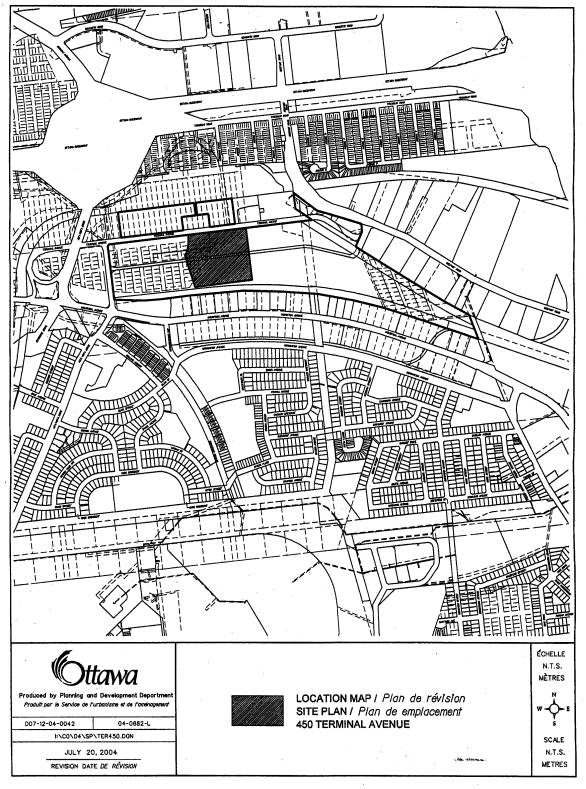
The Site
The subject property is located on the south side of Terminal Avenue, east of Caledon Place. It is approximately 5.65 hectares in size and forms part of a larger development area know as "The Trainlands". To date, "The Trainlands" property, which is approximately 19.64 hectares in size, predominantly consists of a mix of industrial warehouse uses. In 2001 the City approved applications for an Official Plan Amendment, a rezoning and a subdivision to allow construction of approximately 102 000 square metres of commercial office space and approximately 35 000 square metres of retail development. The office space is to be provided on the western portion of the property with the retail component on the eastern. The retail development is to consist of a mix of "Big Box" uses, small retailers and restaurants. The office and the retail areas, while distinct, are intended to function together and complement each other. To date, the only construction related to this development has been a stand alone restaurant at Terminal Avenue and Belfast Road.
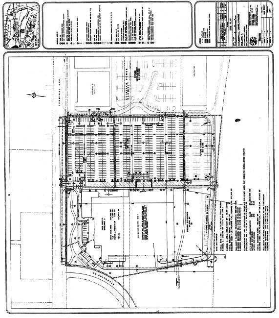
Through this Site Plan Control Application, the applicant is now proposing to construct a large format retail development of approximately 12 417 square metres with a future possible expansion of approximately 4 645 square metres. For the proposed development, the applicant is intending to provide 681 parking spaces. One hundred and sixty-nine additional spaces are to be provided for the future expansion.
The Trainlands Concept
As part of the Official Plan Amendment, City Council approved policies to guide the development of the entire site. A goal of these policies was to realize an overall development that had a significant focus on public transit and other non-vehicular means of transportation and that would exhibit a high quality of urban design, for both buildings and outdoor public areas. This high quality design would help tie the entire site together in aesthetic appeal and function.
To help achieve this goal, policies were included that required development within "The Trainlands" to incorporate a comprehensive integrated pedestrian circulation system having a quality environment and defined cycling routes that linked with the City's larger cycling network. The pedestrian circulation system is to connect not only all the retail uses but the retail and office components, as well as provide a focal point which leads to the transit station north of the site.
Given the importance placed on pedestrian and cycling circulation, as part of the Official Plan Amendment, the property owner was to provide a comprehensive pedestrian and cycling plan for approval by the City. This plan was to ensure vehicular circulation, parking needs and the placement of buildings did not dictate the design of the development but in fact, that the development occurred around the design and functioning of the pedestrian and cycling system. Criteria in creating the pedestrian and cycling circulation plan are provided as follows:
that a main component of the pedestrian system be located adjacent to development;
that the system provide a focus on the area where a pedestrian connection to the Ottawa Train Station is to be developed;
that the pedestrian area be well landscaped;
that the pedestrian routes be of a width so as to sustain an animated environment providing opportunity for the provision of pedestrian amenities such as benches, outdoor cafés, at grade retail, commercial kiosks and other uses that would sustain interest and activity;
that these pedestrian areas be clearly defined with a minimal conflict with vehicular movement.
In the context of the site specific policies established in the Official Plan for "The Trainlands", the appropriateness of the applicant's Site Plan application must be evaluated relative to the aforementioned principles.
DISCUSSION
Orientation of Building
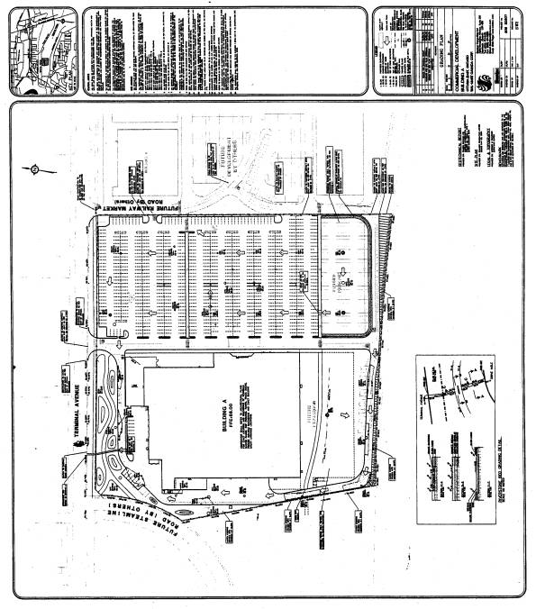
One of the fundamental concerns with the proposed development is its location and orientation. The building is to be located and oriented in a manner that cuts the entire site in two. Rather than facilitating the connection between the retail and the office components, it will act as a barrier, a wall that people will be forced to travel around in order to go between these two areas. This will not achieve the pedestrian connectivity anticipated by the approved policies. As well, any connection along the southern portion of the subject property would be lost through the proposed future expansion of the building. Through a stand alone single purpose building that divides, rather than connects these two areas, the opportunity for the continuous pedestrian system which minimizes conflicts and establishes direct links will be lost.
Another concern related to the location and orientation of the building is parking. This is proposed to occur in a large rectangular block to the east of the building and is a predominant feature of the development. The design of "The Trainlands" retail component anticipated by the Secondary Plan and the approved subdivision, has parking occurring on either side of a "spine road" that travels through the centre of the retail portion of the site. Parking occurring in this fashion would help facilitate a continuous line of building development along the edge of the site. This design would also facilitate a high quality, wide, safe and well animated pedestrian pathway system along the face of these buildings where conflicts with parking areas are minimized. The parking proposed results in a significant break in this retail continuity. People will have to walk approximately 125 metres between storefronts. No longer is there a continuous facade, buildings are disconnected and fragmented, which is detrimental to the pedestrian system.
Further to this, the orientation of the building will result in the loading occurring on the side of the building facing the office component of "The Trainlands". When traveling from west to east along Steamline Road, this loading and the back wall of the project will become the predominant points of focus. It is expected that these features will in turn, compromise the viability of the office building to be constructed adjacent to this building. The previous concept plan, upon which the approved subdivision is based, has loading occurring away from the main areas of activity, along the fringes of the development. in a way that does not negatively impact on the aesthetics and overall integrity of the development.
Lack of Amenities
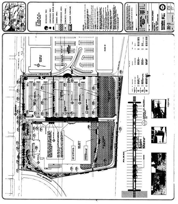
Another concern regarding the proposed Site Plan is the lack of a friendly, safe, animated environment where the pedestrian circulation is to be provided. Nowhere in the revised plan has the applicant attempted to incorporate amenities to capture pedestrian interest, such as cafés or commercial kiosks. The entire circulation system is void of activity. The pedestrian walkways pass along features such as a blank wall, a wall with windows that are only ornamental in nature, a wall where the predominant features are the overhead garage doors and outdoor storage and a wall where loading is occurring. As well, the southern pathway is intended to disappear in the future with the expansion of the building.
The landscaping proposed is minimal and sporadic. For example, there are only a total of three trees planned for the entire 130.5 metre length of the eastern wall of the building, which contains the main entrance. Similarly, the pedestrian pathway across the southern portion of the property, while approximately 110 metres long has only six trees proposed on either side of the pathway. The City standard is one tree per every seven metres, which would equate to a minimum of 30 trees along both sides of the entire pathway. While the northern pathway is somewhat more landscaped, the amount proposed needs to be augmented to mitigate against its location between Terminal Avenue, outdoor storage and the automotive repair area.
With respect to the width of the proposed walkways, the area along the eastern face of the building and the parking lot are too narrow to facilitate safe and adequate two way pedestrian circulation. In the case of the walkway along the building this is a major constraint to providing the required pedestrian animation mentioned. With respect to the parking lot, the walkways are designed so that vehicles parked adjacent to them will infringe on the overall width of the walkways and thus their safety. As well, the principle walking area of the pathways through the parking areas is too narrow (1.5 metres). The presence of park benches in this case offer a further restriction to the narrowness of these walkways and instead of benefiting as they should, they offer a further hindrance to the safe circulation of pedestrians. This in turn contributes to the hostile environment of the proposed development.
Transit Focus
A central focus to the Secondary Plan for the trainyards was the emphasis on the integration of pedestrian routes with public transit. The area of the site where the pedestrian systems for the retail and office components merge is located on the south side of Terminal Avenue, which was to lead to the Transit Station north of the site. The approved pedestrian and cycling plan suggests that this area would be developed with open space and be animated with a pad restaurant or convenience retail. This area would then lead across Terminal Avenue to the office area and the transit station. The proposed building is now located in this space and no such amenities are offered. Instead, the building is a significant barrier to having this area serve as a focal point for pedestrian activity, which brings people between the retail and office components and to and from the transit station.
In conclusion, pedestrian pathways were intended to be designed in a way that patrons of the retail component and employees were invited to walk among and between the existing uses, instead of using their vehicles to drive to and from uses. It is the Department's position that this plan shows hostile pedestrian linkages that will not only promote but require people to use their vehicles to travel amongst the retail uses and to and from the office component.
In addition to Site Specific Policies, the Secondary Plan also refers to Development Criteria contained in the former City of Ottawa Official Plan Section 4.6.2. j) that must be addressed when determining the appropriateness of a development proposal. It is the Department's opinion that this application does not satisfy these policies which call for a development that accommodates pedestrian movement within the site that is safe, convenient and aesthetically pleasing. The design of development should not result in extensive hard surfaced areas for parking but instead is to provide a street presence through a continuity of store fronts contributing to a human scale of development. Parking and loading areas are to be adequately screened and landscaped. As presented in this report, the location and orientation of the building, the lack of a convenient and safe pedestrian circulation system having amenities and adequate landscaping, and the provision of a large expansive parking area, all combine to result in the failure to comply with these criteria.
New Council Approved Official Plan
The new Council Approved Official Plan designates the subject property as Mixed-Use Centre. Lands with this designation have been identified as strategic locations on the rapid transit network or adjacent to major roads. They represent a critical element in the City's growth management strategy and have a high potential to achieve compact and mixed-use development. They are limited in number and represent opportunities for substantial growth. They should contain a wide variety of uses that serve both the local community and are regionally oriented. Development within Mixed-Use Centres are to offer ease of access on foot and by bicycle. By virtue of careful attention to design, orientation and a mix of uses, development within a Mixed-Use Centre will contribute to the diversity of land use in the immediate area and foster the creation of vibrant centres of activity. Development within Mixed-Use Centres can proceed prior to the completion of the required Community Design Plan, subject to compliance with specific policies. It is the Department's position that the Site Plan submitted does not satisfy these policies and has the following concerns.
The proposed Site Plan does not contribute to a compact, urban, pedestrian oriented form and function that enhances pedestrian accessibility, strengthens walking as the preferred means of getting from place to place and does not add significantly to beneficial pedestrian amenities, such as textured paving, seating and landscape areas.
The proposal is poorly integrated with transit. The building is situated in a manner that defines the personal vehicle as the primary means of transportation and contributing to this is the location of the main entrance in the middle of the building, away from Terminal Avenue or other transit routes to be created. The building does not contribute to mobility choices other than a private vehicle as the other alternatives are hostile, unfriendly with no pedestrian amenities. Pathways proposed are inadequate in width and do not offer direct access between important and desirable destinations. They do not provide for functional public spaces, parks or plazas, as they are either non-existent or where they do exist, inadequate in size, desirability and function. For example, the Department does not believe that people will stop and rest on a bench that is along a walkway which is 1.5 metres wide, in the middle of a parking lot.
Developments in mixed-use areas are intended to have surface parking areas redevelop over time with other uses. In this instance, this is not anticipated to occur as the amount of parking provided is needed to comply with the Zoning By-law and is significantly below (83 spaces) the amount of parking the applicant believes they need for their purposes.
In addition to the policies mentioned above, development in "Mixed Use Areas" must also satisfy the policies contained in Section 2.5.1. These policies relate to the compatibility of the proposed development with the surrounding properties, with emphasis on architectural characteristics. As "The Trainlands" development is separated from the surrounding residential neighbourhoods, concerns related to predominant architectural characteristics such as long blank walls, a lack of landscape treatments, expansive parking facilities and the lack of doors and real windows, are not expected to have a negative impact on these residential areas. What is of concern, is that given the distinct policy intent of the Secondary Plan for "The Trainlands" and the policies contained in the new Council Approved Official Plan, the aforementioned characteristics of the proposed development will not be compatible with future developments in the Trainlands, that satisfy these policies. Instead, the lack of compatibility of this proposal will be even more evident and will become foreign to the positive character created by these other buildings.
Concurrent Applications
There are no concurrent applications related to this property within "The Trainlands". However, there is a rezoning application relating to lands at the far eastern portion of the property to allow large format retail development.
CONSULTATION
Notice of this application was carried out in accordance with the City's Public Notification and Consultation Policy. Information signs were posted on-site indicating the nature of the application. The Ward Councillor is aware of this application and the staff recommendation. The City did not receive any negative comments or opposition to this application.
FINANCIAL IMPLICATIONS
N/A
APPLICATION PROCESS TIMELINE STATUS
This application was not processed within the timeframe established for the processing of Site Plan Control applications due to an attempt between the City and the applicant to resolve fundamental issues regarding the proposed development.
SUPPORTING DOCUMENTATION
Document 1 - Location Map
Document 2 - Site Plan
Document 3 - Landscape Plan
Document 4 - Grading Plan
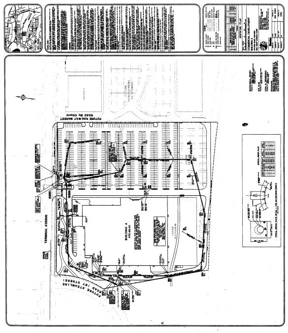
Document 5 - Servicing Plan
DISPOSITION
Department of Planning and Growth Management to notify the owner (Wal-Mart Canada Corp. 1940 Argentia Road Mississauga, Ontario L5N 7M9), the applicant (Holzman Consultants Inc., 1076 Castle Hill Crescent, Ottawa, Ontario K2C 2A8), All Signs, 8692 Russell Road, Navan, ON K4B 1J1, and all interested parties of Planning and Environment Committee's decision.
LOCATION MAP Document
1
SITE PLAN Document
2
LANDSCAPE PLAN Document
3
SITE GRADING AND DRAINAGE Document 4
CONDITIONS OF SITE PLAN CONTROL APPROVAL Document 5