Report
to/Rapport au :
Planning and Environment Committee
Comité de l'urbanisme et de
l'environnement
and Council / et au Conseil
13 January 2006 / 13 janvier 2006
Submitted by/Soumis
par : Ned
Lathrop, Deputy City Manager /
Directeur municipal adjoint
Planning and Growth Management / Urbanisme et Gestion de la croissance
Contact Person/Personne
ressource : Grant Lindsay, Manager / Gestionnaire
Development Approvals / Approbation des demandes
d'aménagement
(613) 580-2424 x13242, Grant.Lindsay@ottawa.ca
|
SUBJECT: |
OFFICIAL PLAN and zoning 6350 FERNBANK ROAD (FILE
NO. D01-01-04-0018 and D02-02-05-0048) |
|
|
|
|
OBJET : |
REPORT
RECOMMENDATIONS
That the Planning and Environment Committee recommend that Council:
1. Approve and adopt an amendment to the City Council Approved
Official Plan, the Official Plan of the former Township of Goulbourn and the
Official Plan of the former Region of Ottawa Carleton to redesignate part of
6350 Fernbank Road from “Significant Wetlands” to “Urban Natural Feature” and
“General Urban Area”, and from “General Urban Area” to “Urban Natural Feature”,
as detailed in Documents 3, 4 and 5; and
2. Approve amendments to the former Township of Goulbourn Zoning
By-law to change the zoning on 6350 Fernbank Road from “W” (Wetland Zone), “RU”
(Rural) and “D” (Future Development Zone) to “NEA-1” (Natural Environment
Special Exception Zone), “NEA” (Natural Environment Zone), “PR” (Parks and
Recreation Zone), “R1-XX” (Residential Type One Special Exception Zone), and
“R4-XX” (Residential Type Four Special Exception Zone) as detailed in Document
7.
RECOMMANDATIONS DU
RAPPORT
Que le Comité de
l’urbanisme et de l’environnement recommande que le Conseil :
1. approuve
et adopte une modification au Plan officiel approuvé par le Conseil municipal,
au Plan officiel de l’ancien Canton de Goulbourn et au Plan directeur de
l’ancienne Municipalité régionale d’Ottawa-Carleton visant à changer la
désignation d’une partie du 6350, chemin Fernbank, de « terres humides
d’importance » à « aire à caractéristiques naturelles urbaines »
et à « aire urbaine générale », et d’« aire urbaine générale » à « aire à caractéristiques naturelles urbaines », comme il est
expliqué dans les documents 3, 4 et 5; et
2. approuve
les modifications au Règlement de zonage de l’ancien Canton de Goulbourn afin
que soit modifié le zonage du 6350, chemin Fernbank, de « W » (zone de
terres humides), « RU » (zone rurale) et « D » (zone à aménagement futur) à
« NEA-1 » (zone à environnement naturel – exception spéciale),
« NEA » (zone à environnement naturel), « PR » (zone de
parcs et loisirs), « R1-XX », (zone résidentielle de type 1 –
exception spéciale) et R4-XX (zone résidentielle de type 4 – exception
spéciale), comme il est expliqué dans le document 7.
BACKGROUND
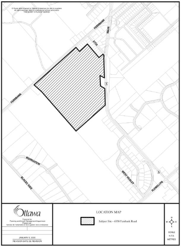
The subject property is located in the south end of the Village of Stittsville fronting on the south side of Fernbank Road west of Etta Street and Stittsville Main Street (see Document 1). The total size of the property is 28.28 hectares. Part of the Fernbank Wetland is located along the west and north property lines. The site is designated, in the respective Official Plans, and zoned as follows:
|
|
Council Approved |
Region |
Goulbourn |
Zoning |
Wetland Portion
|
Significant Wetlands |
Significant Wetlands |
Provincially Significant Wetlands |
“W”- Wetland |
Remainder of Site |
General Urban |
General Urban |
Residential |
“D”-Future Development “RU”- Rural |
The Fernbank Wetland
In 1999 the Ministry of Natural Resources (MNR) notified the former Township of Goulbourn and the former Region of Ottawa Carleton that the Fernbank Wetland had been re-evaluated and did not meet the criteria to be considered a Provincially Significant Wetland (PSW). The Region initiated an Official Plan Amendment (OPA) to amend the Regional Official Plan to remove the Significant Wetland designation from the entire Fernbank Wetland area. In response to a subdivision application on lands to the north of the subject lands, known as the Westwood Subdivision, (which contained a part of the Fernbank Wetland) a local environmental group (Goulbourn Wetlands Group) provided the MNR with new technical information and requested that the MNR reconsider the boundary. As a result of the review of this new information, MNR expanded the size of the wetland. This increase in size brought the wetland within 750 metres of the Upper Poole Creek Wetland. This proximity resulted in the MNR amending their opinion on the Fernbank Wetland and in 2000 indicated that the Fernbank Wetland should continue to be considered a PSW as it could now be “complexed” with the Upper Poole Creek Wetland. As a result of this change in MNR’s opinion, the Region ceased processing of the OPA and the wetland remained designated Significant Wetland.
In keeping with MNR’s findings, staff refused to proceed with the Westwood Subdivision application until it was revised to reflect the new MNR Fernbank Wetland boundary. The proponents for the Westwood Subdivision appealed the refusal to proceed with the subdivision and zoning applications to the Ontario Municipal Board (OMB). It was their position that the wetlands should not be “complexed”. The Fernbank Wetland should be considered to be locally significant and therefore at least a small part of it would be able to be developed. The OMB’s decision was that the subdivision should be approved. The consequent development of this subdivision has removed the wetland area within 750 metres of the Upper Poole Creek Wetland. As a result, the MNR are no longer of the opinion that the Fernbank Wetland is Provincially Significant as it cannot be “complexed” with the Upper Poole Creek Wetland.
The City Council Approved Official Plan carried forward the designations with respect to significant Wetlands shown in the Regional Official Plan and the Goulbourn Official Plan. Staff recognize that the designation is no longer appropriate for the Fernbank Wetland and have initiated an OPA to redesignate the entire wetland area. Staff were however postponing the OPA until the Reach 2 of the Jock River and Flowing Creek Subwatershed Study was complete such that additional information regarding the rural portion of the wetland was available. Staff indicated to the owners of the subject land, however, that if they wished to move their development forward, they could initiate an OPA themselves specific to their lands.
Consequently, an application was submitted requesting that the City Council Approved Official Plan, the Regional Official Plan and the Goulbourn Official Plan be amended to redesignate the wetland portion of the subject site from Significant Wetlands to a less restrictive environmental protection designation. It is necessary to amend both the former Region of Ottawa Carleton Official Plan and the former Township of Goulbourn Official Plan as all the Provincially Significant Wetland and Urban Natural Feature policies in the City Council Approved Official Plan are under appeal.
DISCUSSION
At the request of City staff, an environmental study was submitted in support of the application. This report provides information with respect to the existing conditions of the wetland, a more detailed delineation of the wetland boundary and a professional opinion on the impacts of development on the wetland. The application and the environmental report were circulated to the Rideau Valley Conservation Authority (RVCA). Staff from RVCA and Ministry of Natural Resources (MNR) conducted a site visit to confirm the wetland boundary in the field. As a result of the site visit, the wetland boundary was confirmed and agreed to by the applicant.
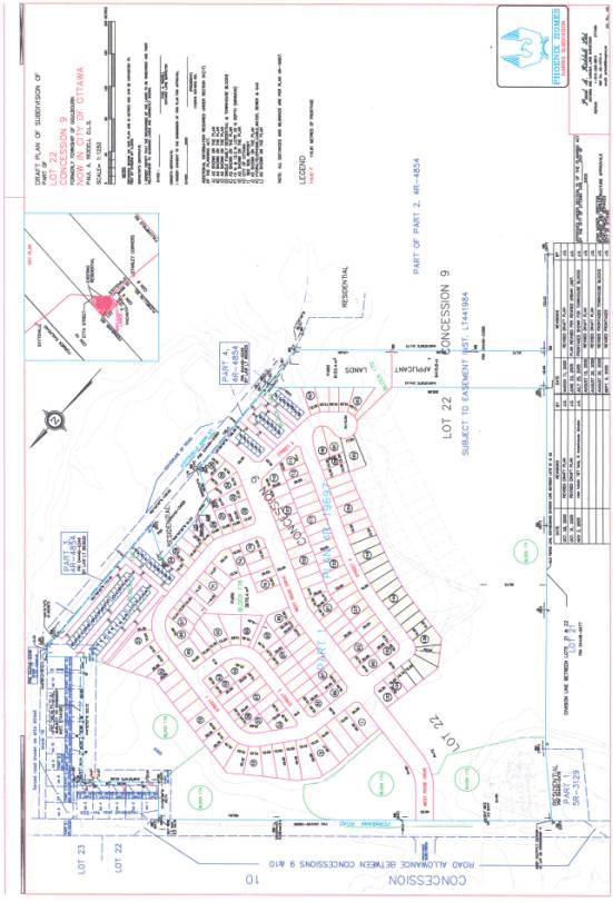
A Zoning By-law amendment application has also been submitted to change the current “W” (Wetland), “RU” (Rural), and “D” (Future Development) zoning under the former Township of Goulbourn to a combination of the following zones: “NEA-1” (Natural Environment Special Exception Zone), “NEA” (Natural Environment Zone), “PR” (Parks and Recreation Zone), “R1-XX” (Residential Type One Special Exception Zone), and “R4-XX” (Residential Type Four Special Exception Zone). The purpose of the Zoning By-law amendment application is to implement the Official Plan amendments and permit the development of the lands as reflected in the companion Draft Plan of Subdivision application (see Document 2).
The draft plan includes the southern extension of West Ridge Drive from Fernbank Road through to Stittsville Main Street. The subdivision is largely made up of single detached lots with two townhouse blocks along the frontage of Stittsville Main Street. Two neighbourhood parks are being proposed, one central to the subdivision, and one along the southern edge of the site. The application also includes, in the north west corner of the property, an isolated pocket of single detached units, on a single loaded road, extending south from Fernbank Road, and a storm water management block fronting on Fernbank Road and the West Ridge Drive extension. The remainder of the property is to be conveyed to the City for protection as an environmental protection area.
Rationale
The Fernbank Wetland is no longer considered a Provincially Significant Wetland (PSW) and is, therefore, no longer protected under the provisions of the “Significant Wetlands South and East of the Canadian Shield” policy of the Provincial Policy Statement. This natural feature does, however, have value at a local level, in particular, hydrological functions, and as a natural feature within an urban setting.
Staff recommend that
the wetland should be recognized as an environmental feature in the respective
Official Plans in order to ensure the significant features and functions of the
wetland are protected.
City Council Approved Official Plan
The Urban Natural Features designation of the City Council Approved Official Plan (Policies 3.2.3) were formulated to apply and protect natural features including wetlands which are important biologically and have social significance (value) but do not meet the criteria to be protected under the PSW policies. The policies state:
Urban Natural
Features provide a valuable contribution to biodiversity and wildlife habitat
in the urban area and are enjoyed by residents. Urban Natural Features are
natural landscapes and may include woodlands, wetlands, watercourses and
ravines.
Additional
Urban Natural Features may be identified on Schedule B in the following
circumstances:
Upon securing
natural areas in the urban area for conservation purposes, through the development
review process…..
The natural feature is protected
by limiting the uses within the feature and requiring an Environmental Impact
Study for any development within 30 metres of its boundary. Uses permitted in
Urban Natural Features are limited to; Uses that do not adversely affect the
natural characteristics of the area, such as open air recreation; scientific,
educational, or conservation uses associated with the environmental
features:…or forestry as defined by the Forestry Act....
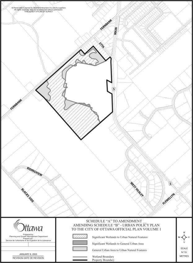
The details of the amendment to the City Council Approved Official Plan are detailed in Document 3.
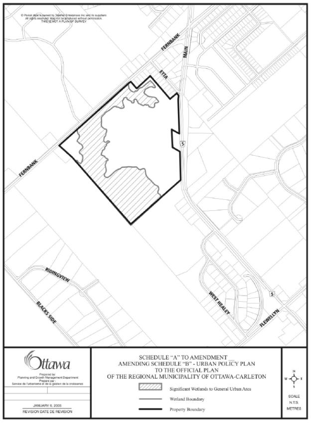
Regional
Official Plan
Amending the Regional Official Plan to remove the Significant Wetlands designation yet provide for continued protection of the feature is more of a challenge as there is not a designation in the Official Plan which was formulated for the protection of urban area that allows for the protection of a locally significant feature. It does however, allow for it in the policy text. Section 5, Natural Environment, of the Region’s Official Plan emphasizes “preserving, protecting, and enhancing a green, clean, and healthy natural environment.” The Plan supports additional work at the local municipal level to recognize and protect local features, particularly in urban areas where smaller woodlands and natural landscapes may be important for both environmental and social values. Section 5, Policies for Natural Environment Areas, allows for locally significant natural features to be recognized through amendments to the Regional Official Plan.
This amendment therefore
proposes to redesignate the site entirely to General Urban Area and that a
policy be added to Section 5.4.5 to identify this wetland as locally
significant and require an Environmental Impact Statement to be prepared for
any development proposal in the vicinity of the feature as detailed in Document
4.
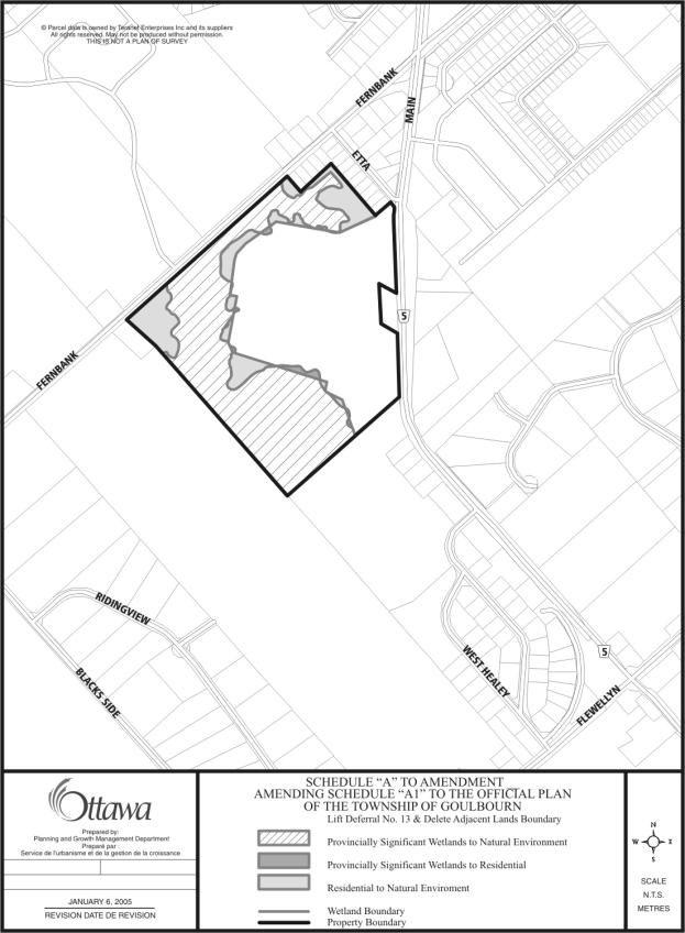
Goulbourn Official Plan
The amendment to the Goulbourn Offical Plan
proposes to change the designation from Provincially Significant Wetland to
Natural Environment Area and apply policies 10.4.1 and 10.4.2 to any
development proposals in and adjacent to the wetland. Similar to the City
Council Approved Official Plan policies for Urban Natural Features, these
policies restrict development to “educational, recreational or scientfic
uses which utilize but do not adversely affect, the natural characteristics of
these areas”.
Although this wetland is no longer considered
Provincially Significant, the Fernbank Wetland is a valued natural resource within
the local environment of Stittsville. The Upper Poole Creek Subwatershed Study,
approved by the former Township of Goulbourn and the former Region, recognizes
this wetland as having locally significant values both environmentally and with
the public. The details of the amendment to the former Township of Goulbourn
are detailed in Document 5.
Urban
Natural Feature Boundary Delineation
The applicant is requesting that the wetland generally be redesignated to Urban Natural Feature but that a development encroachment be permitted. The encroachment would be comprised of the southwesterly most loop road and associated lots (as shown in grey in Document 2). When the subdivision application was first submitted, the encroachment was more extensive than presently being proposed. Staff requested that the plan be revised to “tighten up” the development. Road right-of-way widths were reduced and lot depths were decreased. A second townhouse block was introduced along the Stittsville Main Street frontage. Encroachment into the wetland was considerably reduced without significantly affecting the proponent’s development goals. Despite the proponent’s best efforts to reduce the encroachment, development is still being proposed in the wetland.
This wetland has been assessed using the evaluation framework of
the Urban Natural Areas Environmental Evaluation Study (UNAEES) and found to
place among the urban natural areas considered to have a “High” overall
significance. In the Greenspace Master Plan Public Consultations Details report
to Planning and Environment Committee, staff presented a draft implementation
strategy whereby all high and moderate rated urban natural features be
protected, where feasible. In keeping with the draft implementation
strategy, staff is recommending that Council purchase that portion of the
property which is being proposed for development within the wetland. Staff is
also recommending that the small pocket of land being proposed for single
detached development in the northwest corner be purchased by the City. This
area is comprised of upland forest but is largely contained within the urban
natural feature candidate area along with the wetland. This area is small,
isolated, on a single-loaded road and cannot be connected to the developments
to the north or east without further encroachment into the wetland. These two areas being recommended for
purchase are shown in grey (instead of black) in the proposed plan of
subdivision in Document 2.
The respective Official Plan amendment schedules
have been prepared such that the encroachment area and the upland forest in the
northwest corner have been included in the
Urban Natural Feature/Natural Environment Area designations in
anticipation of the City purchase of these two areas.
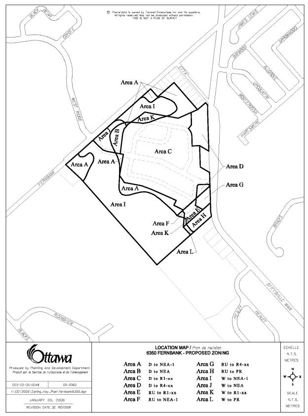
Zoning Details
Residential Zones
The draft plan of subdivision, attached as Document 2, shows the majority of the developable area as single detached lots with two townhouse blocks adjacent to Stittsville Main Street. As a result of the circulation and review of the originally proposed subdivision layout, staff requested that the applicant tighten up the development thereby minimizing the encroachment into the wetland. This was achieved by reducing the right of way width of the internal streets and reducing the lot depths. It is necessary to create a special exception single detached zone to reduce the front yard and rear yard setbacks. Front yard setbacks are being proposed at 4 metres and 3 metres if the garage does not extend beyond the front face of the house and rear yards are being proposed at 6.5 metres as detailed in Document 7.
Townhouse blocks are shown along the Stittsville Main Street frontage. These blocks are being proposed to be developed with private internal streets. No direct access to the units from Stittsville Main Street is anticipated. Units would face or side onto Stittsville Main Street but be accessed at the rear of the unit via a private street internal to the townhouse block. By encouraging the units to face Stittsville Main Street the amount of noise barrier fencing can be minimized. Staff are proposing a special exception townhouse zoning to allow for development on a private street. The details of this zone are presented in Document 7.
Parks and Environmental Protection Zones
The draft plan of subdivision shows a park
central to the development and a second park along the south edge of the
subdivision. The southerly park is proposed to be zoned a PR Zone (Parks and
Recreation), the zone which is generally applied to municipally-owned parks in
the Goulbourn ward. The centrally located park is proposed to be zoned R1-XX
similar to the adjacent proposed single-detached residential development.
Public parks are permitted in residential zones in this by-law. By zoning this
park residential, it will allow for the boundaries of the park to be adjusted
slightly between draft approval and registration as the landowners finalize
their lot layout. The Urban Natural Feature is generally proposed to be zoned
Natural Environment Area Zone (NEA). A small area partially within the wetland
and partially outside of the wetland boundary is proposed to be zoned NEA. The
remainder of the Urban Natural Feature is proposed to be zoned NEA-1, a special
exception zone which permits no uses other than “conservation and passive
park”. The NEA Zone is less restrictive than the NEA-1 Zone and will permit the
establishment of a stormwater management pond.
There remain other opportunities through the finalization of the subdivision application to ensure that the development is designed to maximize protection of the wetland. Measures can be taken within the subdivision to minimize impact through stormwater management, tree preservation, buffer planting and augmentation, wetland monitoring, public awareness handbook and signage etc. An integrated environmental review statement will also be required in support of the final subdivision design to ensure that significant findings from support studies are integrated and assessed as a complete package.
Conclusion
The Fernbank Wetland is no longer
considered a Provincially Significant Wetland (PSW) and is, therefore, no
longer protected under the provisions of the “Significant Wetlands South and
East of the Canadian Shield” policy of the Provincial Policy Statement. However, this natural feature does have
value at a local level, in particular, hydrological functions, and as a natural
feature within an urban setting. The Official Plan amendments, as recommended,
will recognize the wetland as an environmental feature in the respective
Official Plans and provide a level of protection to the significant features
and functions of the wetland. In
keeping with the draft implementation strategy of the Greenspace Master Plan,
staff is recommending that Council purchase that portion of the property which
is being proposed for development within the wetland. Purchase of this land
will ensure minimal encroachment into the wetland and provide a greater level
of protection to this Urban Natural Feature. The Zoning By-law amendment will implement
the OPA’s and the draft plan of subdivision.
ENVIRONMENTAL IMPLICATIONS
The Official Plan amendments, as recommended, will recognize the wetland and the adjacent upland forest as an urban natural feature in the respective Official Plans and provide a level of protection to the significant features and functions of the wetland. Additional protection measures will be explored through the subdivision proposal.
RURAL IMPLICATIONS
Over half of the Fernbank Wetland is located south of the Stittsville Village boundary within the rural area of the city. By protecting the portion of the wetland within the urban boundary the biological integrity of that portion contained in the rural area will not be impacted.
CONSULTATION
Notice of this application was carried out in
accordance with the City’s Public Notification and Consultation Policy. At the request of the Ward Councillor, a
Public Information and Comment Session was held in the community on October 26,
2004 to present the proposed Official Plan Amendment. A Public Meeting under the Planning Act for the
application for Draft Plan of Subdivision was also held in the community on
June 29, 2005. The proposed Official Plan Amendments and the proposed Zoning
By-law amendment application were also presented and discussed at this Public
Meeting.
At the public meeting and through written comments the public posed questions regarding the wetland and raised concerns about the impact of the development of these lands on the existing neighbourhoods. These comments are outlined and addressed in Document 8 of this report.
FINANCIAL IMPLICATIONS
Staff is recommending that Council purchase
that portion of the property which is being proposed for development within the
wetland, as well as, a small pocket of land being proposed for single detached
development in the northwest corner. A report will be coming forward to
Corporate Services Committee outlining the details of this purchase.
APPLICATION PROCESS TIMELINE STATUS
The application was not processed by the "On Time Decision Date" established for the processing of Official Plan Amendments. Due to the presence of the wetland, submission of additional environmental information and review of same by staff and RVCA was required.
SUPPORTING DOCUMENTATION
Document 1 Location Map
Document 2 Proposed
Draft Plan of Subdivision
Document 3 Proposed
Official Plan Amendment (City Council Approved)
Document 4 Proposed
Official Plan Amendment (Region of Ottawa-Carleton)
Document 5 Proposed
Official Plan Amendment (Township of Goulbourn)
Document 6 Explanatory
Note
Document 7 Details
of Recommended Zoning including proposed zone map
Document 8 Consultation Details
DISPOSITION
Department of Corporate Services, Secretariat Services to notify the owner DCR Phoenix Ltd (18 Bentley Avenue, Ottawa, ON K2E 6T8), applicant William Buchanan, All Signs, 8692 Russell Road, Navan, ON K4B 1J1, and the Program Manager, Assessment, Department of Corporate Services of City Council’s decision.
Department of Planning and Growth Management to prepare the implementing by-law and forward to Legal Services Branch, and undertake the statutory notification amendment to the Council Approved City Official Plan, the Goulbourn Official Plan and the Regional Official Plan.
Department of Corporate Services, Legal Services Branch to forward the implementing by-law to City Council.
Document 1
LOCATION MAP
Document 2
DRAFT PLAN OF SUBDIVISION
Document 3
PROPOSED OFFICIAL PLAN AMENDMENT (CITY)
|
|

Official Plan
Amendment **
Modification du Plan directeur
**
To the
Official Plan of the City of Ottawa
Land use
Utilisation du sol