URBAN GROWTH MANAGEMENT – MAIN ASSUMPTIONS DOCUMENT
2
Much comment and
debate has centred on the issues of intensification and urban expansion. These
issues are framed by the amount of growth projected for Ottawa’s population and
the number and types of dwelling units this population is projected to require
over the next quarter century. They culminate in the proposed growth management
strategy of the Official Plan.
The following
sections recap the key facts and assumptions underpinning these issues.
Urban Land Supply
After detailed
analysis, the Residential Land Strategy concluded that by 2031 there is
a shortfall of 6,700 single detached and 1,700 semi-detached dwellings. To
address this a total of 850 hectares (ha) is recommended be added to the urban
area. The 850 ha represents an addition of only 2.4% to the designated urban
area. On an annualized basis, it is
somewhat lower than the 250 ha of residential land that is currently consumed
outside of the Greenbelt each year in Ottawa.
It may appear counter-intuitive that we need to add land with a
lower projection when we did not need land in 2003 with a higher projection.
Three key factors have changed since 2003 which impinge on the supply of single
detached homes and require that land be added for 2031:
1. The supply of land is less than the 2003 Plan provided due to the
last six years of development (roughly 1,500 ha of gross residential land have
been developed), despite the addition by the Ontario Municipal Board of the
Del-Brookfield lands;
2. The anticipated 10-15% increase in the density of single detached
units did not happen (it actually fell slightly), hence there are fewer single
detached units in approved plans;
3.
The analysis in 2003 assumed 60% of
units in community design plan areas would be single and semi-detached. In
fact, CDPs that have been approved provide slightly less than 40% singles and semis,
so there are far fewer single detached houses in the supply.
Population Projections
Projections are
a fundamental cornerstone of the Official Plan and related Master Plans.
Council adopted new projections of population, households and employment for
2031 in November 2007. These represented a significant reduction from the
previous forecast, which was the basis of the 2003 Official Plan (OP).
Some comments
questioned whether the new projections are still too high, particularly in view
of the current economic downturn. Others have suggested the lowest of the three
projections developed should be used, not the middle (Reference) scenario
adopted by Council for the OP review and Master Plans.
The new
projections are in fact tracking actual growth very closely (housing starts
have been within 99.9% of projected over the last two years). The projections
are based on a long-term perspective and account for ups and downs in economic
cycles. The projections were well supported by a peer review and are very
similar to the province’s own projections for Ottawa. They provide a sound
basis on which to plan for the city’s future and there is no reason to revisit
them.
Others have
questioned what the risks are if the projections prove to be too high.
If the projections
are higher than actual growth, Council will have designated a supply of urban
land in excess of 20 years. Municipalities in the Toronto area are permitted by
the province to plan for up to 30 years. There is no financial risk to the City
if there is more than 20 years of land since there is no obligation to provide
services before development is imminent (and in reality the City is often
endeavouring to catch up to existing service needs, not building in advance of
needs).
Housing Demand –
what types of housing will Ottawa need in future?
The major
demographic change over the next two decades is the aging of the baby-boom. Now
aged roughly 43 to 63, by 2031 they will occupy the 65- to 85-age bracket. A
key part of the housing projection is what housing forms this large group will
choose as they transition into retirement and their senior years.
Over the last 25
years, seniors have turned away from apartments in large numbers – in 1981, 55%
of households 65 and over lived in apartments; 25 years later, in 2006,
apartment dwellers had dropped to 38%. Better health and more wealth have been
important factors in allowing many seniors to remain in single detached homes.
The housing projection sees this decline stopping, and evidence of a change appeared
in the 2006 Census data. But there will remain significant ongoing demand for
single detached – many seniors will still choose to age in place.
It is important
to recognize that the housing market, and the land requirements it produces, is
driven by the collective choices people make. City planners and Council can
attempt to influence choices through policies and programs (described by some
as social engineering), but people are fundamentally free to choose. The
housing projection is based on detailed analysis of trends in these choices and
how various cost and environmental factors may influence them. If the housing
projection proves to be significantly off base, and current housing market
trends suggest it is not, there is an opportunity to correct them at the time
of the next OP review in five years.
Requirements for no urban expansion
For the analysis
to support no need to expand the urban boundary, one of two changes would be
required:
a) Revising the
housing projection in such a way that demand for single and semi-detached was
reduced. This would likely be challenging to defend given that almost 50% of
new units built in the last 25 years have been singles. The projection in the Residential
Land Strategy is a 40% share of singles over the next 25 years, which
triggers the need for the proposed 850 ha expansion. For there to be no need
for expansion, the singles share would need to drop even further to about 35%.
b) Leave the
projections as is and plan for a slightly shorter time period. That would mean
instead of a 22-year supply of land for all housing types, the single and
semi-detached supply would be about 18 years. There is an oversupply of land
for townhouses, about 25 years, and an even larger supply of apartment
potential. A slightly smaller supply of land for single and semi-detached may
marginally constrain the market, but an 18-year supply is essentially the same
as when the 2003 Plan was adopted. In five years the next OP review will update
the supply-demand analysis and make appropriate recommendations.
Intensification
target – 40%, or more, or less?
Many comments were made on the 40% intensification target, with many
calling for more. There is nothing in the Plan to prevent higher
intensification from being achieved – the 40% is a minimum target and people’s
choices may result in more. However, several factors may act as limitations to
how high the degree of intensification can realistically go:
·
While Ottawa did achieve a 36%
intensification rate between 2001 and 2006 (as a share of urban units),
significantly higher than in previous periods, some of the intensification
occurred on vacant federal properties sold during the 1990s (e.g. Central Park,
Moffat farm, Carson Grove). In future, intensification will have to rely
increasingly on redevelopment, which is more difficult than building on vacant
land.
·
A larger share of future
intensification than in the past will be in the form of apartments. Many sites
will involve redevelopment of obsolete commercial and other uses on Mainstreets
and Mixed-Use Centres and will only be suitable for apartments. Hence the
amount of intensification will be governed by the strength of the market for
apartments.
While the
housing projection calls for an increase in the share of apartments, the above
factors present challenges to achieving substantially more than the current
rate of intensification. The 40% target is designed to climb over time, from
36% up to 40% by 2011, 40% between 2011 and 2021 and 44% between 2021 and 2031.
The above
factors also present challenges to increasing the amount of intensification in
urban areas outside the Greenbelt, in part because the current pattern favours
locations that are relatively close to the Inner Area.
The Ministry of
Municipal Affairs and Housing is very supportive of the 40% target, noting in
their letter of March 26:
“The identification of clear intensification targets in the Official
Plan supports the direction of the PPS (i.e. section 1.1.2). Given this, we are
pleased to see that the City is working towards, and ultimately surpassing, the
intensification targets that are required in the Growth Plan for the Greater
Golden Horseshoe. Specifically, we are very pleased to see that the City has
set the following targets: 2006-2011 – 36%; 2011-2021 – 40%; 2021-2031 – 44%.”
What can the City
do to encourage intensification?
The OP and draft amendment contain many polices to promote
intensification, including:
·
Reviewing the zoning by-law to ensure
that targets can be met;
·
Creating an Intensification Implementation
Group to coordinate internal and external regulations and standards;
·
Establishing Design Priority Areas as
part of a comprehensive urban design strategy;
·
Investigating financial incentives for
residential mixed-use projects; and
·
Other polices set out in Section 2.
URBAN GROWTH MANAGEMENT–RESPONSE TO SUBMISSIONS DOCUMENT 3
Growth Projections
1.
a) Comment: The City needs more
accurate, realistic and reliable population projections. (10, 229)
b) Comment: The City should seek out the best projection
methods used by other cities. (10)
c) Comment: The projections should use the Statistics Canada
population estimate for Ottawa as the base year, not the City staff estimate.
(229)
d) Comment: The City should adopt the lowest of the three
projection scenarios, not the middle (Reference) projection being used for the
OP review. (35, 229)
Response: The revised projections are a
fundamental part of the Official Plan. The projections adopted in 2001 and
incorporated in the 2003 OP were based on the 1996 Census. Those projections
were prepared by a consultant during the “high tech boom” and annual monitoring
showed they were significantly overstating the city’s actual growth in
population, housing and employment.
The revised projections were based on extensive research. Past
projections were reviewed and compared to how well they forecast actual growth
(“History of Population Projections in Ottawa 1915-2001”, March 2004).
This found that since 1980 the projections with the best record of tracking
actual growth were those prepared by staff. Technical analysis was undertaken
of available projection methodologies, including the techniques employed by
other major Canadian cities (“City of Ottawa Official Plan Projections:
Monitoring Report”, June 2005, unpublished technical report). This
recommended a return to the cohort-survival model used prior to 2001 (the 2001
projection used an economic-based model). The proposed methodology and
discussion of key assumptions was presented to Planning and Environment Committee
(PEC) prior to undertaking the revision (“Background Report on New Growth
Projections for 2006-2031”, June 2007). This explained the new projection
would use a cohort-survival model, it outlined the basis for the three
migration scenarios proposed, it proposed to extend the projection period from
2021 to 2031, and that the results would be peer reviewed by a consultant
before being recommended for adoption by Council.
A draft projections report for public consultation was presented to
Planning and Environment Committee and to Agriculture and Rural Affairs
Committee and to a public information meeting in September 2007. The peer
review by Hemson Consulting received in October concluded that “the forecasts
prepared by the City represent a reasonable basis for long-term planning in the
City of Ottawa,” but did advise caution on three matters:
·
The estimated 2006 population of
870,800 used by the City represented a higher rate of census undercoverage than
existed in 2001 (from a 2001 rate of 4% to about 7% in 2006). It went on to
note that the base year population has no significant effect on the amount of
population growth, a conclusion consistent with staff testing of the model
results. The peer review recommended that the results of census undercoverage
studies be monitored. These subsequently showed a preliminary estimate of 3.4%
undercoverage (a post-censal estimated population of 840,000 compared to a
census count of 812,150). In April 2009 a revised estimate of 845,000 was
released by Statistics Canada, amounting to 4.0% undercoverage. It is expected
that a further revision will be issued in 2010.
It bears repeating that
staff are of the opinion that the present method of estimating Ottawa’s current
population provides the best estimate of the actual number of people for which
the City provides services. The size of the base year population has no
appreciable effect on the amount of growth projected.
·
Projected dwelling unit types. The
September draft projections report presented two alternative projections of
dwelling types. The first applied fixed 2001 (the most recent available at that
time) housing choices by age of household head to the projected population. The
alternative applied projected changes in housing choices, and was based on a
significant shift away from single detached houses (from 49% of new units
2006-31 to 30%). Hemson were of the opinion that while some shift was likely it
would not occur as quickly as the draft scenario. The consultants agreed with
the staff recommendation that the housing projections be revisited after
detailed data was obtained from the 2006 Census. The results of that work are
discussed in the section dealing with urban land requirements.
·
On the employment projection, the
consultants questioned whether the projected increase in working among people
over 55 was overstated, but noted the effect of this on total employment was
very small. Recent data are consistent with the City projection.
The projections were also compared to those prepared by the Ontario
Ministry of Finance for Ottawa in 2005. The province projects an increase of
266,200 population between 2006 and 2031, virtually the same as the City
forecast of 265,000.
At the Council meeting of November 28, 2007, the new projections
were adopted as the basis of the Official Plan review and the updates to the
Transportation Master Plan and Infrastructure Master Plan. The final report, “Growth
Projections for Ottawa: Prospects for Population, Housing and Jobs, 2006-2031”
was published the same month.
Monitoring of projected versus estimated actual growth since 2006
shows that as of the end of 2008, estimated population growth is slightly above
projected. It is normal even with the most accurate projections to have minor
variations between projected and actual growth from year to year. However, in
land use terms, new housing is the most important factor because it is the
largest single consumer of urban land. Growth in dwelling units has been
virtually identical to projected; housing starts averaged 6,449 during 2007-08,
compared to 6,457 units projected for those years in the “Residential Land
Strategy” (Appendix 3).
2.
Comment: Projections may be too high in light of the recent economic
downturn. (241, 247)
Response: The projections cover a 25
year period (2006-2031) and are intended to take account of the lows and highs
of economic cycles. Staff monitor and report growth annually and revise
projections at five year intervals if required.
3.
Comment: Planned development in the expansion areas will not meet the needs
of our aging population. (245)
Response: Projected housing requirements
reflect an increase in the up-take of apartments among seniors, a reversal of
what has been happening for the last 20 years. But there is still ongoing
demand for single detached units from younger households and from the
significant number of seniors that choose to remain in single detached houses
(today’s seniors have better health and are more affluent than any previous
generation). If housing patterns change significantly that can be addressed
when the projections are reviewed in five years.
4.
Comment: The projected shifts in housing choices will only happen slowly.
The staff projections represent an untested and unachievable experiment in
social engineering. (56)
Response: A shift away from single
detached houses and toward apartments has been observed in recent years. The
projection is that over the next 22 years an average of 40% of new dwellings
will be single detached. In 2008, housing starts in Ottawa were 40.8% singles,
so it appears this shift may be well underway. A variety of market, cost and
environmental factors support this direction continuing. This issue is
extensively discussed in the Residential Land Strategy report.
5.
Comment: Submission 178 said the City should revise housing projections,
aiming in particular for substantial shifts from single detached to row
housing. Submission 188 said that the housing projection contained in “Growth
Projections for Ottawa” was swept aside and replaced with one weighted
toward detached houses. (178, 188)
Response: The November 2007 projections
report contained two scenarios for housing demand. The first projected that 47%
of new units would be single detached units, based on 2001 Census data for
housing types occupied by different age groups. The second scenario postulated
a significant change in the housing market, resulting in only 30% of new units
being single detached. The peer review by Hemson Consulting advised that 30%
was likely too large of a shift and advised the City to re-evaluate the housing
projection after 2006 Census data became available. That was done and it was
determined that a revised scenario with 40% single detached was more realistic
while still representing a significant shift to higher density housing forms.
The Greater Ottawa Homebuilders Association (submission 56) believes that 46%
of new housing will be single detached.
Regarding townhouse demand, staff do not foresee significant
increases because most of the townhouse market is comprised of people under 50,
with many under 35. Projections are that 70% of future growth will be among
people over 50. Hence, although the popularity of townhouses is projected to
increase significantly among younger households (see Appendix 2, Scenario 3 in
the “Residential Land Strategy”), aging of the population limits the
likelihood of major increases in the share of townhouses.
Past projection practices have simply applied the housing patterns
of the previous census to future demand. By departing from this and projecting
a shift in the housing market away from single detached staff are endeavouring
to place the city’s future on a more sustainable footing. Whether the housing
market follows that trend will be monitored annually to determine whether any
updated projection should reflect changes in the shares of detached houses,
townhouses and apartments.
6.
Comment: Apartments use more energy than detached houses, and will
discourage people from changing from lower to higher density housing. (69)
Response: The study cited to support this
(Survey of Household Energy Use) reported that energy intensity per square
metre of floor space was 10% higher in low rise apartments than in detached
houses. However, if allowance is made for the smaller floor area of apartments,
less total energy is required. The study also noted that most apartments
surveyed were older pre-1980 construction and less energy efficient than the
newer singles surveyed. Results also varied widely depending on whether the
occupant was responsible for paying energy costs; energy intensity was less
than half if they paid for the energy.
7.
Comment: Figure 2.2 should include Kanata, Orleans and the other urban
centres outside the Greenbelt. Given the need to address the jobs/housing
mismatch in the urban centres (and the need to justify extending LRT to these
communities), it makes sense to include projected jobs, households and
population with a finer grain than the one proposed. (209)
Response: It is proposed to retain the
more general level of information in Figure 2.2 that was proposed in March. The
figures in 2.2 are only projections, not policy. Providing the greater level of
detail that is in the 2003 OP resulted in the projections being treated as
Council policy, which the projections were never intended to be. In order to
avoid this, more detailed projections will be provided but outside of the OP.
For the purposes of monitoring policies such as the balance of jobs and housing
in each urban centre, this is a matter of assessing employment and population
potential, not projections. Employment potential is based on OP designations,
CDP’s and other sources. Potential population is based on existing population
plus potential on vacant residential land and potential that can be added
through intensification. The analysis does not use projections.
Intensification and Targets
8.
Comment: Submission 38 stated the intensification target should be higher
than 40%. Submissions 191 and 204 said the target should be 50%. Submission 138
said it should be 60%. Submission 178 said it should be more or less 100%. (35,
138, 178, 191, 204)
Response: The actual degree of
intensification can be higher than 40% if consumers make the choice to live in
higher density housing. As noted in the “Residential Land Strategy”,
there is physical potential for much more intensification than is targeted. The
target is set at 40% because it is considered a reasonable balance between what
is realistically achievable if the housing market continues to shift to higher
densities and the challenges of a higher degree of intensification which in
future will depend increasingly on redevelopment of existing properties rather
than building on tracts of vacant land.
9.
Comment: A more realistic target for intensification is 26%. (56)
Response: Further to the previous
response, staff maintain that a 40% target is appropriate for Ottawa. It is not
credible that having recently achieved 36% that there would be such a
significant decline, especially in light of provincial direction to plan for
intensification. The level actually achieved will be monitored and reported
annually.
10. Comment: Intensification targets should
be higher; for example, the City of Montreal has a density of 10,257 persons
per square kilometre, compared to only 3,783/sq. km inside Ottawa’s Greenbelt.
(35, 138, 178, 220)
Response: The City of Montreal is
without question a higher density city than Ottawa, in fact it is one of the
highest density large cities in Canada. That is due to its relatively older age
and the very extensive areas of dense three-storey walk-up apartments built in
the late 19th and early 20th centuries. The density
figures quoted are, however, in error. The City of Montreal’s actual (2006
Census) density is 4,439 persons/sq.km; for the Island of Montreal it is 3,715
persons/sq.km. Ottawa’s density inside the Greenbelt is 2,881 persons/sq.km.
While Ottawa is less dense than Montreal, it is not nearly to the degree stated
in the submission. (For example, if the entire Montreal urban area is looked
at, per Appendix 1 of submission 178, Ottawa is only slightly less dense than
Montreal, and is more dense than Vancouver.) A fundamental objective of the
Official Plan is to increase Ottawa’s density in such a way as to support the
rapid transit system.
11. Comment: The key target should be density
not intensification. (178)
Response: The Plan provides for both
density targets and intensification targets. Density targets are appropriate
for guiding site-specific development at locations where the development
strategy of the OP seeks to focus higher densities of both housing and jobs. In
most cases this is at locations that assist in achieving the City’s rapid
transit plan. An overall intensification target is established to provide a
mechanism for the City to achieve overall higher density development and to
reduce future expansions of the urban boundary.
12. Comment: Targets of 50 people per
hectare should be set for the overall built-up area. (178)
Response: The present density of the
urbanized area of Ottawa is approximately 29 persons per gross hectare. While
proposed polices for the urban expansion areas would see about 50 persons per
gross hectare, staff do not believe that increasing the density of built-up
areas by over 70% is practical or that the effects on established
neighbourhoods would be acceptable.
13. Comment: A target of 400 people or jobs
per hectare in the major Mixed-Use Centres and Arterial Mainstreets should be
identified. (178)
Response: The target of 400 people and
(not “or”) jobs is established in the provincial Growth Plan for the Greater
Golden Horseshoe (GGH) only for downtown Toronto and four other urban growth
centres within the City of Toronto. Growth centres outside Toronto have a
target of 200 people and jobs per hectare. The proposed density target for
Ottawa’s Central Area is higher than Toronto (this is partly due to the much
larger and diverse nature of downtown Toronto). Two Mixed-use Centres have
targets of 250 people and jobs per hectare and several have the same targets as
the GGH. Given the smaller, less dense character of Ottawa and that existing
densities in many areas are far from achieving the targets, staff are of the
opinion that they are appropriate to this city.
14. Comment: Make the Bayshore Community a
target area for intensification. Bayshore should be treated as one community
and one which is suitable for building heights of 10 storeys or more. (181)
Response: Targets areas for
intensification include land within 600 metres of rapid transit stations. This
includes a large part of the Bayshore community but not all of it. Section 4.11
also indicates that high-rise buildings (10 or more storeys) may be considered
for lands located within 600 metres of a rapid transit station. Other
locational criteria for high-rise buildings would also apply to parts of the Bayshore
community. Details are established through the zoning bylaw. No change to the
Plan is recommended.
15. Comment: Several submissions supported
the notion of intensification and the proposed intensification targets. (18,
27, 66)
Response: Noted with thanks.
16. Comment: All current and proposed LRT
stations should be targeted for density increases. (138)
Response: Areas within 600 metres of
rapid transit stations are among the target areas for intensification. Rapid
transit stations at Mixed-use Centres, Town Centres and in the Central Area
have specific target densities, but not every station has a specific target.
That will vary depending on the character of the surrounding area and it is not
practical to create specific targets for each station.
17. Comment: There should be explicit
targets in the Plan for Traditional Mainstreets. Submission 70 also asked if
there is a CDP planned for Bank Street in the Glebe in the near future. (70,
138, 174, 179, 180)
Response: Targets for housing units on
Traditional Mainstreets are contained in the “Residential Land Strategy”
(Figure 34). They are not incorporated in the amendment as density targets largely because in most cases existing densities are very
high already and the zoning and lot fabric will lead to high densities without
the aid of targets. Even the longest of Traditional Mainstreets are at or above
"subway-level" density benchmarks (200 people and jobs per hectare).
For example, Bank Street is now 200 people and jobs/ha, Wellington West is 240,
and Rideau Street is over 400. Bank Street in the Glebe is not currently a high
priority for a CDP.
18.
Comment: Development outside the urban area, such as in
villages, must pursue intensification and have targets. (138)
Response: Similar to proposed policy 14 of Section 2.2.2, small
scale intensification in villages is supported where it will enhance and
complement the village and its long-term renewal. As in low-rise residential
neighbourhoods in the urban area, no targets are proposed.
19. Comment: Submissions 2, 43 and 188
expressed support for the interdepartmental / external stakeholder group on
intensification (policy 12.a and Residential Land Strategy, 2006-2031)
and inquired when it would be starting. Submission 34 opined that the review of
practices or regulations of internal agencies that may be at cross-purposes to
the City’s intensification goals needs to be addressed and needs a political
champion. (2, 34, 43, 188)
Response: Similar sentiments were
expressed during the Intensification Roundtable session held in June, 2008.
Many people commented that the Intensification Implementation Group, as set out
in the Residential Land Strategy and as inferred through Section 2.2.2
policy 12.a, needs profile if its recommendations are to be taken seriously.
Whether this is in the form of a political “champion” or through senior staff
has yet to be determined. The establishment of the interdepartmental and
external stakeholder group is expected to be in 2009.
20. Comment: The means for measuring
intensification and density should be made clear and given legal status through
incorporation in the Plan. (188)
Response: The amendment introduces a
definition of what constitutes residential intensification based on the PPS.
Staff are of the opinion that this provides sufficient clarity and legal status
for this to be measured without serious challenge. The calculation of the
density of people and jobs can involve many variables and does not lend itself
to a rigid definition within the OP. For example, the number of people will change
depending on the type and size of proposed dwelling units and as new census
data becomes available. The number of jobs varies considerably depending on the
type of use (retail, office, industrial, etc) and on types within these major
categories – for example, a small retailer typically employs more people per
square foot than does a large format retail operation. In addition, the
proponent may have specific information on the number of employees that will be
located within a development. Staff are developing detailed guidelines for
implementing this policy but they will not be part of the Plan.
21. Comment: The density targets for people
and jobs per net hectares should not use equal proportions of each. The policy
should use gross density not net density. (69)
Response: The policy provides that
targets can be met through any combination of people and jobs. Net density is
used since the policy will be applied on a property by property basis as
development applications come in.
22. Comment: Submission 69 makes many other
comments related to density targets, mixed use development, and appropriate
locations for intensification.
Response: After careful review of the
submission, there are no recommended changes to the proposed policies in the
Plan.
23. Comment: Density targets could be
misinterpreted to mean that a single development has to increase the
density of the entire area or street up to the density target. (188)
Response: Density targets apply only to
the specific development, not the area. To make this clearer, it is proposed in
Section 2.2.2 policy 7 to change the phrase “all new development” to “each new
development”.
24. Comment: Density targets are expressed
in people and jobs per hectare while the overall intensification target is in
terms of dwelling units only. Is this deliberate or an oversight? (188)
Response: The difference is deliberate.
Density targets per net hectare are intended to guide site-specific development
in the Central Area, in Mixed-Use Centres and on Mainstreets. A blend of
population and jobs is appropriate given that the Plan seeks to encourage a mix
of land uses in these areas. The overall intensification target of 40% applies
only to residential development since the majority of new employment is already
created through some form of intensification. New housing drives the expansion
of suburban areas and the target is intended to reduce the amount of land it
consumes.
25. Comment: The density target for Billings
Bridge for 2031 is lower than it was 2006. This requires explanation or clarification.
(129)
Response: Billings Bridge is classified
as an “emerging Mixed-Use Centre” (MUC) in the Residential Land Strategy. All
emerging MUCs were assigned targets of 120 people and jobs per hectare.
However, it does create an anomaly since Billings Bridge had a density of 130
in 2006. To address this it is recommended that Figure 2.3 be amended by
changing the 2031 target for Billings Bridge to 160.
Demand for Additional Urban Land
26. Comment: Why are we adding land when
with a higher projection in 2003 there was no need? There was also 450 hectares
added after the 2003 Plan was adopted. (138, 188, 202)
Response: The 450 hectares was added by
an OMB decision on the Del-Brookfield lands in order to provide additional land
for single detached houses. A detailed analysis in Residential Land Strategy
for Ottawa, 2006-2031 concluded that an additional 850 residential hectares
are needed to provide sufficient land to 2031. Although it may appear
counter-intuitive that more land is needed with lower growth, several key
factors have changed:
·
The total supply of residential land
available today is lower than what the 2003 Plan provided due to land consumed
over the last six years, despite the addition of the Del-Brookfield lands.
·
The density of single detached houses
did not achieve the 10-15% increase that was anticipated in 2003. The
expectation was that a firm urban boundary would result in development making
better use of the land supply by building at higher densities. In fact, the
density of single detached units built over the last five years is slightly
lower than it was five years before. This means more land is required for the
same number of units.
·
The proportion of single and
semi-detached houses planned in each suburban Community Design Plan is also
lower than was anticipated in 2003. The analysis for the 2003 Plan assumed that
60% of greenfield units would be singles and semis. In CDPs approved to date,
less than 40% of units are singles and semis. This significantly reduces the
total supply of these units, and adds to the need to expand the urban boundary.
As a result of all the above factors, there is
an insufficient supply of land for projected single detached and semi-detached
units for 2031.
27. Comment: Submission 188 questioned that
even though there is a surplus of supply for townhouses and apartments, staff
are recommending that land for these be added to the urban expansion areas.
This increases the land required by 40%. Submission 229 questioned adding this
land on what it described as “just a community design principle.” (188, 229)
Response: In order to avoid creating
areas that would be entirely comprised of single detached houses, the amendment
includes additional land in the expansion areas to allow for townhouses and
apartments. This adds 233 hectares to the 620 gross hectares required for
singles and semis, an increase of 38%. It is desirable to provide communities
of mixed housing types to allow for a range of incomes and age groups to be
accommodated.
28. Comment: The minimum density of 26
units/net ha for single detached in expansion areas and new CDPs should be
increased. Higher densities can be found throughout Ottawa. (35, 188)
Response: The 26 units/ha density
represents an increase of 27% over what has been built in Ottawa suburbs in the
last five years. While it true that single detached dwellings can be built at
even higher densities, the proposed change is a significant increase.
29. Comment: The proposed minimum densities
for single detached are commendable. (69)
Response: This policy is retained in the
draft amendment.
30. Comment: Submission 56 disagrees on the
desirability and practicality of what amounts to a radical shift in densities
that can realistically occur over 25 years. (56)
Response: A density of 26 units/ha for
single detached is being achieved by at least one builder in Ottawa today, and
can be achieved by other development. There are several examples of single
detached development in other cities with even higher densities. Many of
Ottawa’s older neighbourhoods were also built at higher densities and remain
desirable areas in which to live.
31. Comment: Density targets of 26 units per
hectare for single detached and 32 units/ha overall should be established and
monitored at the CDP level (not at the subdivision or site specific level).
This will permit a variety of single detached houses consistent with market
demand and the character of the area being developed, while still meeting the
overall target at the CDP level. (169)
Response: The concern of staff is that
if targets are established only for the whole CDP that allow for individual
applications to vary as they perceive the market, builders early in the
development process will build well below the target density, leaving those
coming later having to build at perhaps impractically high densities in order
to achieve the overall target. However, to provide
some flexibility and a variety of densities within an area, a detailed
development plan can be prepared that will show a variety of densities for
single detached and other housing that achieves the target averages of 26 and
32 units per hectare. Builders will be required to follow the plan when
submitting development applications.
32. Comment: The proposed minimum densities
for suburban development (policy 19 of Section 2.2.2 and policy 4.a.ii of
Section 3.6.4) are still very low. The proposed minimum for single detached of
26 units per net ha is about the same density as the veterans’ quarter in the
Carlingwood area and this is by no means high-density development. The
submission states one way to avoid expanding the urban boundary is to increase
densities in any new suburban developments. (35)
Response: The overall minimum density
target proposed on greenfields is 34 units per net ha. The figure of 26 units
per net ha applies to single detached units only and has been recommended
because while the existing Official Plan density requirements on greenfields
have been met, it has been because of increased proportions of townhouses and
stacked townhouses in the overall housing mix. Single detached dwellings have
continued at the low densities for this housing type that has been observed for
the last 25 years. The proposed target density of 26 units per net ha is
significantly higher than what has been observed in recent history – between
1983 and 2007 it has largely remained between 19 and 21 units per net ha. The Residential
Land Strategy, 2006-2031 demonstrates that the proposed density can be
achieved in a variety of ways that will not unduly restrict choice in the market.
33. Comment: The urban expansion will set in
place conditions that can lead to oversupply in terms of types and numbers of
housing units, a situation much more lethal to housing markets than
undersupply. (229)
Response: The suburban housing industry
does not typically build new housing unless there is a buyer. The spectre of
oversupply is therefore very unlikely to occur. Moreover, the City does not
extend services significantly in advance of actual development occurring. In
the case of there being too much land designated, that should act to keep land
prices relatively low and assist housing affordability. An undersupply of land
would have the opposite effect.
Growth Management
34. Comment: Concerned due to the proposed
urban expansion that Smart Growth principles are not being addressed. (27, 178)
Response: The proposed changes to the
Plan focus on implementing intensification, supporting the existing and
proposed rapid transit network with appropriate higher density land uses and
requiring higher density development in suburban areas. These are all
fundamental “smart growth” principles.
35. Comment: There should be a maximum of 1%
of new buildings in the rural area. (178)
Response: This would require a virtual
freeze on all rural development. In order to provide choice for those wishing a
village or rural lifestyle, as well as to avoid further increases in the number
who live outside Ottawa and commute here to work, staff do not support this.
Council has previously rejected a proposed stop to new rural subdivisions.
36. Comment: Cities with vibrant transit
systems and walkable neighbourhoods have overall densities of at least 35-40
people per hectare, preferably more like 50. (178)
Response: Ottawa’s current urban density
is approximately 28 persons per gross developed hectare. The OP as proposed to
be amended will move Ottawa toward higher densities. However, because we add on
average only 1.5% annually to the total number of dwelling units the average
will not change quickly.
37. Comment: Development outside of intensification
target areas should be very limited and comprise at least 85% townhouses and
apartments. (138)
Response: Current policies for CDP areas
require that at least 40% of units be townhouses and apartments and the
proposed amendment would apply the same policy to urban expansion areas. Actual
CDPs approved to date provide 60%. Given that current plans do not provide a
sufficient supply of single detached and semi-detached units to 2031, to
require an even lower proportion of singles and semis would be self-defeating
unless projected housing requirements drastically reduced their future demand.
Given housing market trends this does not appear realistic.
38. Comment: Intensification is not
appropriate on lands subject to natural hazards. (87)
Response: Any development may not be
appropriate on hazard lands, not just intensification. The Plan has established
designations and polices to address these hazards.
Expansion Areas
39. Comment: If the 850-hectare figure only
includes residential land, is there a need for additional land for employment
and other purposes? Land should be added to provide jobs that are close to
residents. (202, 188)
Response: No additional land is required
for employment and other purposes. The “Employment Land Strategy, Phase 1”
report (November 2008) concluded the current supply of employment land was more
than sufficient for the planning period. Gross residential land includes
provision for population-serving jobs such as those found in schools and local
retail, as well as other major land uses such as roads and parks.
40. Comment: Given that the provincial
requirement is to maintain a 10-year supply of land designated for residential
development, why is the recommendation to expand the urban boundary based on an
estimate for more than 20 years? (184, 202, 247, 272)
Response: The PPS allows municipalities
to plan for up 20 years (Section 1.1.2). In order to provide the longest
horizon possible for the purposes of transportation and infrastructure
planning, the City is planning for the maximum length of time permitted under
the PPS. Because the planning horizon year is always based on a census year, it
extends to 2031, slightly more than 20 years. (More detail on the 10-year
requirement is in the Response to submission 202 below.)
41. Comment: What is meant by “sufficient
land will be provided”? Does it mean it is to be immediately included in the
urban area? Why does the Official Plan’s 20-year supply go beyond the
provincial requirement to designate a 10-year supply of land? (202)
Response: The reference to “sufficient
land will be provided” means that is designated as Urban Area now or will be
included as a result of the proposed amendment. The 10-year supply of land for
housing is the minimum amount of land for residential purposes that must be
provided under the PPS. Because the Plan is updated every five years, a minimum
15 years must be provided so that a 10-year supply remains at the end of the
five-year period.
42. Comment: Urban boundary expansions
should avoid the inclusion of agricultural lands, significant wetlands, forests
and other lands that could make up the Natural Heritage System. Concerned that
the proposed lands include Rural Natural Features (RNF) in areas 1f and 3, and
a Natural Environment Area (NEA) in area 5b. (202)
Response: Areas selected for possible
urban expansion exclude all designated agricultural, natural environment and
wetland areas. The only exceptions are 5a, which is agricultural land entirely
surrounded by urban area, and a Natural Environment Area in 5b which is owned
by the City and will also be entirely surrounded by urban area if the rest of
5b is made urban, as is recommended. The amendment seeks to have Rural Natural
Features (RNF) dedicated to the City at no cost. In parcel 3, however, the
trees have been cleared.
43. Comment: The City is planning for more
sprawl by adding more urban land. (18, 229)
Response: Development of the expansion
land must achieve 26 units/net hectare for single detached and 32 units/net ha
for all dwellings overall. In the case of singles, this is about 25% higher
density than what has been built in the last five years and is much higher than
development that is usually termed “sprawl”.
44. Comment: Please restrict the spread of the suburbs. (27, 41, 66)
The proposed amendment minimizes the amount of land added by
requiring significantly higher densities for new suburban development.
45. Comment: There should be no expansion of
the urban boundary. (33, 35, 138, 188, 204, 248)
Detailed analysis concluded that some additional urban land is
required to provide land for single and semi-detached dwellings to the year
2031. The 850 hectares proposed represents an increase of only 2.4% in the size
of the designated urban area.
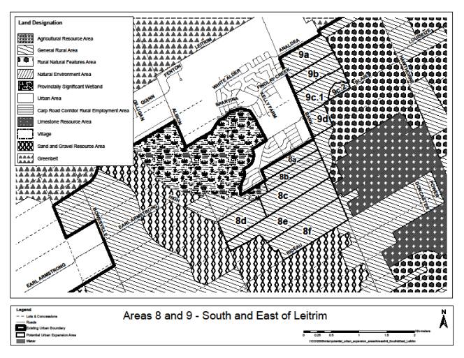
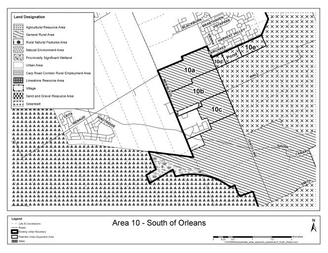
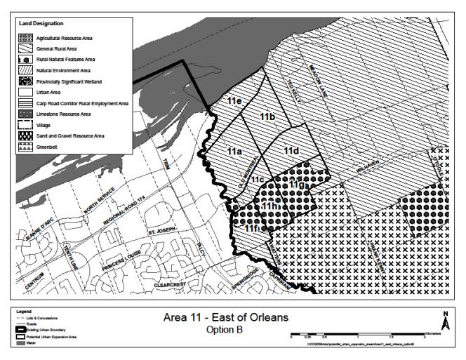
46. Comment: Area 11 represents 28% of the
land for proposed boundary expansions. Area 11 represents approximately
one-third of the 800 ha proposed. (245, 247)
Area 11 represents 13% of the developable land under consideration.
This is a smaller share of the total under study than areas 1, 8 and 10 and is
therefore not unduly large. Of the land recommended for inclusion, Area 11
contains 19% of the total additions. This is comparable to several other areas
(e.g. south Orleans, Fernbank, north Kanata).
47. Comment: The densities of the expansion
areas are a long way from the minimum densities required to support the
proposed rapid transit network. (245)
Given that a density of at least 80 to 120 people and jobs per gross
hectare is required to support “possible rapid transit”, land that is being
provided for a mix of single detached, semi-detached, townhouses and apartments
is very unlikely to achieve these levels. However, the expansion areas will
provide approximately 50 people and jobs per gross hectare which is well within
the range for “good bus service”. This will allow for good bus connections to
the nearest rapid transit line.
URBAN EXPANSION AREAS –
PROPOSED OFFICIAL PLAN
AMENDMENT DOCUMENT
4
BACKGROUND
The
comprehensive five-year review of the Official Plan has identified the need for
an additional 850 ha of urban residential land to meet the requirements of the
population to 2031. In order to
identify areas for expansion, a comparative evaluation of candidate areas was
undertaken.
Document 5
explains the methodology and responds to issues raised during circulation of
the proposed amendment. Document 6
summarizes the review of candidate areas.
Based on that
analysis, this amendment proposes to do the following:
- Include in the urban boundary, two
parcels of land within the Fernbank Community Design Plan (CDP). They will be identified as Future
Urban Area on Schedules A and B and will be dealt with through the
Fernbank CDP process (see Schedule R35).
- Identify four areas as Urban
Expansion Study Area on Schedule B and not designated on Schedule A
but identified in outline. These
areas are larger than the others and more complex and will require a
subsequent Official Plan Amendment to be brought into the urban area. During consultation, the community, the
developer and the City will identify any requirements that must be met
before development proceeds (such as road widening or buffering) along
with all of the other study requirements identified in the proposed
amendment. In addition, the
requirement for a subsequent Official Plan amendment allows for additional
consultation and public meetings to resolve issues. The three areas are north of Kanata
(Schedule R34), Barrhaven South (Schedule R36) east of Orleans (Schedule
R37) and south of Orleans (Schedule 38).
- Identify four areas as Developing
Community (Expansion Area) on Schedule B and Urban Area on Schedule
A. No Official Plan amendment will
be required to develop these lands in recognition of their smaller size
and lesser complexity. However,
the proponents will still be required to complete all of the identified
studies to the satisfaction of the City before development proceeds. It is expected that informal
consultation will occur along with the formal public meeting associated
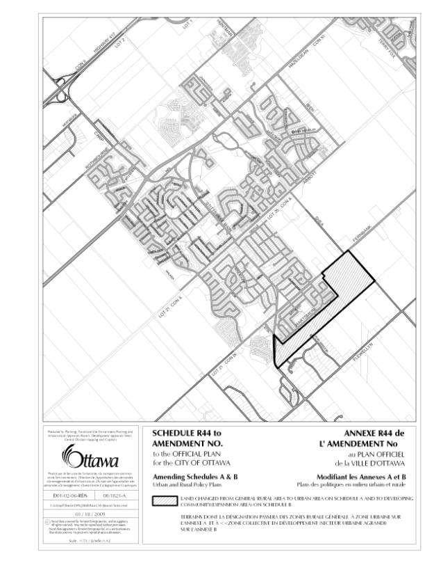
with a plan of subdivision. The four areas are north of Stittsville and
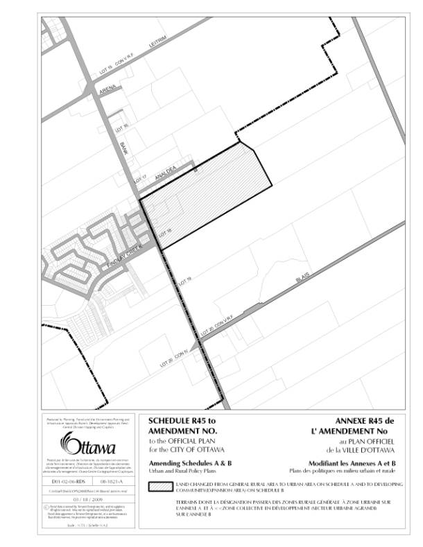
south of Stittsville (Schedule R44), in Leitrim (Schedule R45) and other
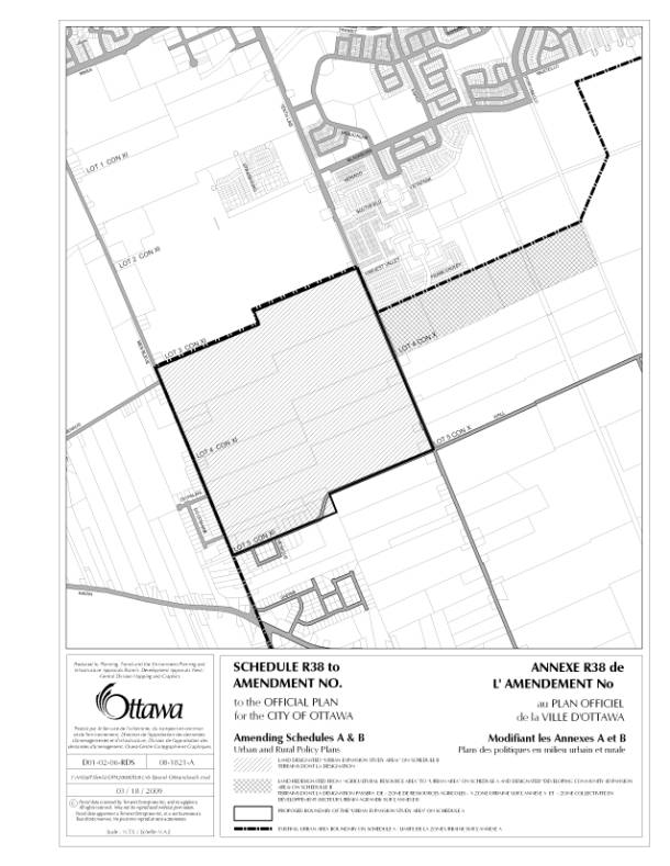
areas south of Orleans (Schedule R38)
The Amendment
3.12 – Urban
Expansion Study Area
The designation
of Urban Expansion Study Area on Schedule B contributes to the provision of
sufficient urban land to support the residential demands of the projected
population to 2031. These lands will
develop primarily for residential purposes, although minor, non-residential
uses to meet the needs of a neighbourhood may also be located here. A comprehensive study will be required prior
to bringing these lands into the urban area.
1.
Lands are designated on Schedule B as
‘Urban Expansion Study Area’ with the intent that these lands will be evaluated
for development primarily for urban residential uses, once the policies of this
section have been satisfied. An
Official Plan amendment will be required to provide a General Urban Area
designation. The amendment may also be
required to implement infrastructure, environmental and open space provisions
of plans approved for individual areas.
2.
The type of study and development plan
required to achieve the policies of this section will be agreed to in advance
and may be a community design plan or a concept plan. Either process will require a comprehensive consultation process
with the community to identify issues and potential solutions.
3.
Where the development plan impacts
multiple landowners, it is their responsibility to collaborate on the
preparation of the plan and to agree on how parks, stormwater ponds and any
other facilities will be located and costs shared. The City will require a landowners’ agreement addressing these
matters prior to the review of development applications.
4.
Proponents of development will
complete, to the satisfaction of the City, studies and a plan of sufficient
detail to:
a)
Identify the location, timing and cost
of roads and transit facilities, water and wastewater services, public
utilities, stormwater management facilities, etc. required on-site and off-site
to service the area; and
b)
Identify the natural heritage system
on the site independent of the potential developable area. Typically an environmental management plan
as described in Section 2.4.2 will be prepared where a subwatershed study does
not exist or does not provide sufficient guidance to identify the environmental
features on the site and their functions, which together constitute the natural
heritage system. The components of this
system are generally described in Section 2.4.2, with the exception that
significant woodlands are to be further evaluated consistent with the Urban
Natural Areas Environmental Evaluation Study.
No development is permitted within this system, which is to be conveyed
to the City for public use before development of the area is approved; and
c)
Identify Recreational Pathways on the
site; and
d)
Evaluate the adequacy of community
facilities existing or planned for the area in consultation with School Boards
and other providers of community facilities;
e)
Show how the plan will achieve other
policies of this Official Plan including, but not limited to, housing mix and
densities and affordable housing; and
f)
Meet the requirements of Phase 1 and 2
of the Environmental Assessment Act where required.
5.
Proponents of development will prepare
a Financial Implementation Plan and commit to providing:
a)
The on-site and off-site servicing
systems described above through development charges or at the expense of the
developer; and
b)
The natural heritage system as
non-developable lands to be transferred to the City for $1; and
c)
The Recreational Pathways as
identified in this Plan through development charges or at the expense of the
developer.
3.13 - Developing Community (Expansion Area)
The designation
of Developing Community (Expansion Area) on Schedule B and Urban Area on Schedule
A contributes to the provision of sufficient urban land to support the
residential demands of the projected population. These lands, none of which is very large, will develop primarily
for residential purposes, although minor, non-residential uses to meet the
needs of a neighbourhood may also be located here.
1.
Lands designated on Schedule B as
‘Developing Community (Expansion Area)’ and ‘Urban Area’ on Schedule A
contributes to the provision of sufficient urban land to support the
residential demands of the projected population to 2031. The intent is that these lands will be
developed primarily for urban residential uses, once the policies of this
section have been satisfied.
2.
The policies of this section will be
achieved through the preparation of a plan of subdivision.
3.
Proponents of development will
complete, to the satisfaction of the City, studies and a plan of sufficient
detail to:
a)
Identify the location, timing and cost
of roads and transit facilities, water and wastewater services, public utilities,
stormwater management facilities, etc. required on-site and off-site to service
the area; and
b)
Identify the natural heritage system
on the site independent of the potential developable area. Typically an environmental management plan
as described in Section 2.4.2 will be prepared where a subwatershed study does
not exist or does not provide sufficient guidance to identify the environmental
features on the site and their functions, which together constitute the natural
heritage system. The components of this
system are generally described in Section 2.4.2, with the exception that
significant woodlands are to be further evaluated consistent with the Urban
Natural Areas Environmental Evaluation Study.
No development is permitted within this system, which is to be conveyed
to the City for public use before development of the area is approved; and
c)
Identify Recreational Pathways on the
site;
d)
Show how the plan will achieve other
policies of this Official Plan including, but not limited to, housing mix and
densities and affordable housing; and
e)
Meet the requirements of Phase 1 and 2
of the Environmental Assessment Act where required.
4.
Proponents of development will prepare
a Financial Implementation Plan and commit to providing:
a)
The on-site and off-site servicing
systems described above through development charges or at the expense of the
developer; and
b)
The natural heritage system as
non-developable lands to be transferred to the City for $1; and
c)
The Recreational Pathways as
identified in this Plan through development charges or at the expense of the
developer.
5.
An amendment to this Plan will not be
required to remove the designation of Developing Community (Expansion Area) and
replace it with General Urban Area, but an amendment may be required to
implement infrastructure and open space provisions of plans approved for
individual areas. Development may
proceed once the City is satisfied that the requirements of this section have
been met and the City has approved the plan of subdivision.
URBAN EXPANSION AREAS – METHODOLOGY AND RESPONSE
TO SUBMISSIONS DOCUMENT
5
1. Selection of Candidate Areas
1.1.
Inclusion of Agricultural Areas
as Candidate Areas
|
Comment:
|
No
Agricultural Resource Areas should be included as Candidate Areas for urban
expansion (146, 148)
|
|
Comment:
|
No lands that
are being farmed, or that could be farmed, should be included as Candidate
Areas (57, 122, 163, 203)
|
|
Comment:
|
Should look to
farmland for expansion rather than environmental areas (222)
|
|
Comment:
|
Should
consider agricultural designation in context of all the other factors that
influence the decision (269)
|
Response:
The basic
premise behind the identification of candidate areas was to avoid Agricultural
Resource Areas as defined in the City’s Official Plan.
- staff included an Agricultural
Resource Area in Kanata/Stittsville because it is completely surrounded by
planned urban development and because it has been planned for urban
development in the Fernbank Community Design Plan. As well, an area designated Agricultural Resource Area south of the
Avalon Community in Orleans was included because it has never met the
requirements on its own to be designated Agricultural Resource Area and
there is a large stormwater management pond in the middle of it. Nowhere else did staff consider lands
in that designation.
- Staff included a criterion that
penalizes a candidate area for being within 500 metres of an Agricultural
Resource Area, to take into account the potential for conflicting uses.
- Staff recognize that some General
Rural Areas are being farmed or were once farmed. A General Rural designation applies if
the land is not rated as prime agricultural land. Urban expansion cannot occur on
environmental lands or Agricultural Resource Areas so it is assumed that
the least resource impact will be in General Rural Areas.
- Some have argued that farmland
should be looked at for expansion because it avoids important natural
areas or because it can make sense from an efficiency point of view in a
specific area. For this staff look
to the Provincial Policy Statement (and Council’s current Official Plan)
for guidance. It is clear that
urban expansion ought not to take place on Agricultural Resource Areas
unless there is no reasonable alternative that avoids these lands. It is also clear that this must be
interpreted in the context of many other objectives in land-use planning
policy. On balance however, staff
believe that there is so much land available in a General Rural Area
designation within the candidate areas that no argument can be made to
expand onto Agricultural Resource Area.
1.2.
Inclusion of Natural
Environment Areas and Rural Natural Features
|
Comment:
|
Natural Environment Area in Stittsville should not be redesignated
as Future Urban Area (146, 148)
|
|
Comment:
|
Should not
include Rural Natural Feature areas within Candidate Areas (146, 97)
|
|
Comment:
|
Should ensure
adjacent natural heritage areas are not impacted (16, 57, 97)
|
Response:
The objective of
the work is to avoid Natural Environment Areas and Provincially Significant
Wetlands in the identification of Candidate Areas. Then, as a first step, proponents will identify the natural
heritage features on the site and remove them from the developable area. Staff have estimated the potential amount of
floodplain, wooded areas, ravines etc.
However, without actually getting on the property, the presence or
absence of a rural natural feature cannot be confirmed.
- There is no intention of removing
the Natural Environment Area in Stittsville and it is acknowledged that
was awkwardly dealt with in the report.
The intent was to recognize that those lands are part of the
Fernbank Plan, all the lands of which are currently designated Future
Urban Area in the Official Plan.
The Fernbank Plan, in turn, would keep them as Natural Environment
Area. To avoid any
misunderstanding, they are not being included in the Fernbank Plan but
will remain as they are currently designated in the Official Plan. The designation will not be touched.
- Staff need to rely on field
assessments to determine the Rural Natural Features on the site. These will be protected in any
development plan. The objective is
to ensure that the City secures these features as part of the Natural
Heritage System.
- Proposed policies in Section 2.4.2
of the Official Plan establish where an Environmental Impact Statement is
required relative to components of the Natural Heritage System, whether or
not they are designated in the Official Plan. These policies will be complied with in any development plan
for the expansion areas.
1.3.
Inclusion of Mineral Aggregate
Areas
|
Comment:
|
Mineral
Aggregate Resource Area has been included in Area 7 which means the resource
will not be extracted.
|
Response:
It is
intended that the Sand and Gravel be extracted prior to development of the
site. That clarification has been added
to the proposed Official Plan Amendment itself (see Section 5 below).
2.
Evaluation Methodology
|
Comment:
|
At the public
meeting on March 31, 2009 and through meetings and verbal comments, various
questions have been raised on the evaluation methodology. This Section explains the basis for the
evaluation.
|
2.1.
Selection of Criteria
Staff reviewed a
number of sources vis-à-vis criteria to evaluate the relative merit of urban
development, or the impact of urban development. The sources included:
- The Regional Development Strategy
(the RDS) from the former Region in 1996
- The GRIDS study in Hamilton in 2003
- Malone Given Parsons (MGP)
submission, 2005
- Canadian
Homebuilders Association (CHBA) – Guidelines for the development of
Environmentally Responsible Communities
- City of Ottawa
Sustainable Environmental Design Checklist
- East-West
Corridor Light Rail Transit Project (EA) Evaluation
of Alternative Alignments
- Provincial Policy Statement (PPS)
In the final
analysis the Provincial Policy Statement provided the best framework for
establishing criteria. The RDS was
extremely detailed and it was good at establishing the “relative” scores. For each criterion, three choices existed
for scores. GRIDS criteria were often
matters that were already subsumed by the designation in our Official Plan or
would be addressed through policy. The
MGP submission used very high-level criteria that are difficult to
quantify. Both the CHBA and Sustainable
Design Checklist were more oriented to the actual development or site and not
useful for comparing potential expansion areas.
The PPS provides
a comprehensive but high-level framework for selecting criteria. It was reviewed to identify those factors that
could be used to compare areas since the objective is to identify the
‘relative’ merit of expanding the urban boundary in different areas. Other factors would apply equally to any
land-use scenario and show up in policy.
So, for example,
Section 1.1.3.2 says “land-use patterns within settlement areas shall be based
on densities and a mix of land uses which are appropriate for and efficiently
use the infrastructure and public service facilities which are planned or
available ….”. This allows for a comparison
of areas relative to existing or planned infrastructure. On the other hand, Policy 1.6.4.5 talks
about when partial services shall be permitted and this is a policy that
applies throughout the city and cannot be translated into a criterion.
The list of
criteria described in Section 3 below was derived in this way. All the policies of the PPS were reviewed
and when appropriate, converted to evaluation criteria.
2.2.
Inclusion of non-measurable
considerations
It is difficult
to capture all considerations with criteria and scores. The report now includes some additional
information that has not been quantified.
It is there for the information of Council and others.
2.3.
Use of ‘essential’ and
‘desirable’ criteria
|
Comment:
|
The suggestion was made that there should be two categories of
criteria. Essential criteria are
those that receive a pass or fail grade and desirable criteria are those that
are measurable but only for the areas that received a passing grade on the
essential criteria (241). Others have
emphasized this point by stating that an area should achieve a threshold
point score in certain criteria before it is considered further (249, 250)
|
Response:
Staff agree in
part.
The
establishment of criteria to identify “candidate” areas are the essential
criteria. So, for example, the area is
not Agricultural Resource, is not a Natural Environment Area, is not a
Provincially Significant Wetland, is a logical extension of the current urban
area and so on. The assumption has been
made that all of the candidate areas are serviceable. However, based on some assumptions about serviceability, part of
area 11 has been removed from the evaluation because of the difficulty of
servicing (southwest along Cardinal Creek).
Essential
criteria include those considerations that will reduce the developable
area. These include for example, lands
that are within 500 metres of a landfill, floodplains, natural heritage
features that will be identified in more detail, setbacks from limestone
resources and so on.
Some have made
the point that adding more development where there is a poor jobs to housing
ratio is inappropriate (241, 265) and in fact, the amount of residential
development should be tied to the creation of jobs. The Official Plan has a target jobs-to-housing ratio of 1.3. Ideally each large community would achieve
this balance. This is not the case
everywhere and in Orleans in particular there is a poor relationship between population
and the number of jobs. The Official
Plan can only provide the land, the infrastructure and the transportation
system to support jobs but it cannot make the jobs happen. Ironically, in this community the transit
ridership levels are higher than anywhere else in the city because many trips
are between the community and the Central Area. Staff are not recommending that residential development in
Orleans cease pending an improvement in the number of jobs.
An extremely
difficult criterion is transportation capacity. That is discussed in more detail below.
2.4.
Poor Road Capacity Should
Eliminate Areas from Consideration
Many submissions
have expressed concern that development is being considered in areas where
there is no road capacity (73, 96, 247, 248, 249, 250, 251, 252, 253, 254, 255,
256, 257, 259, 260, 263, 264, 265, 266). Most of these relate to Area 11 in former Cumberland where the
score for road capacity was “0”. Such a
score did not mean “no” road capacity, but rather expressed a score “relative”
to the others.
Staff have
carefully reviewed all of the assumptions regarding road capacity and have
included a description of road capacity in every section. The transportation models were consulted to
get a more accurate assessment of capacity.
In fact there is road capacity for Area 11 and other areas score much
worse. Road capacity is measured across
a screenline. It looks at the capacity
of all roads crossing that line. It
makes assumptions concerning the future (2031) volume of traffic wanting to
cross that line. The volume to capacity
ratio is calculated and if it is greater than 0.9 or 90%, it is considered to
be at capacity.
This is a quote
from the Transportation Master Plan: Based
on an understanding of current capacities, road modifications to preserve a
maximum 90% demand-to-capacity ratio were identified. System-wide operation at
100% of capacity is not desirable because even minor collisions or weather
impacts could lead to network instability and gridlock; operation at 90% of
capacity is more efficient and would yield acceptable peak period congestion. Only
in the Urban Core (bounded by the Ottawa River, Rideau River, Queensway and
O-Train line) is operation at 100% of capacity acceptable for planning purposes
– a position that reflects a greater tolerance for congestion and the physical
impracticality of road expansion in that area.
A reassessment
of transportation capacity scores has been undertaken using the screenline data
and is included in the evaluation of Candidate Areas.
3. Review of Criteria Used
3.1.
How Criteria have Changed
Through the Public Process
This list
documents the changes in the evaluation criteria between the March 2009 version
of the report and this version. The
scores may have changed on re-examination but this list identifies whether or
not the criterion itself changed. The
actual criteria in detail are found in Document 6.
3.1.1.
Water infrastructure: no change
3.1.2.
Wastewater infrastructure: no change
3.1.3.
Stormwater: while the score continues to be out of 4, no parcel received a
score higher than 3.
3.1.4.
Road capacity: this has been entirely recalculated using
screenline data and level of service in 2031.
3.1.5.
Arterial and collector frontage: no change
3.1.6.
Rapid transit score: no change
3.1.7.
Distance to Mainstreet or Mixed-Use
Centre: no change
3.1.8.
Jobs-housing balance: no change
3.1.9.
Distance to major recreation facility: in Leitrim the score was a combination of
the distance to the Fred Barrett Arena and the Sawmill Creek Pool to recognize
that together these perform much of the function of a major facility.
3.1.10.
Emergency score: no change
3.1.11.
Community connectivity: This was included in the preliminary draft
but excluded in the March report. It
has been reintroduced based on concerns raised by many.
3.1.12.
Local bus: This is a new criterion and provides a score for the presence of
a local bus currently to the parcel
3.1.13.
Agricultural land conflict: no change
3.1.14.
Adjacent country lot or landfill –
potential conflict: The landfill
conflict was introduced to recognize the concern for odours up to one km away
from the Trail Road site. The score for
adjacent country lot development was weighted by 2 to reflect the concerns
expressed in the community.
3.1.15.
Depth to bedrock score: the categories were reduced to collapse all
those areas of over 5 metres in response to comments made by the development
community.
3.1.16.
Urban land supply: no change
3.1.17.
Presence of soil constraints: this was deleted because of the suspect
nature of the data sources at this scale of review. These matters will be addressed as the technical studies are done
on each site.
|
Table
3.2: Potential Evaluation Scores
(weighted) by category
|
Category
|
Criterion
|
Weighted
Score
|
% of total
|
|
Engineering
|
Water
|
8
|
9
|
|
|
Wastewater
|
8
|
9
|
|
|
Stormwater
|
8
|
9
|
|
|
Depth to
Bedrock
|
2
|
2
|
|
Total
engineering
|
|
26
|
30%
|
|
Transportation
|
Capacity
|
6
|
7
|
|
|
Accessibility
|
8
|
9
|
|
|
Rapid Transit
|
10
|
11
|
|
Total Transportation
|
|
24
|
27%
|
|
Integration
with Community
|
Distance to
MUC/MS
|
5
|
6
|
|
|
Ability to
work in community
|
3
|
3
|
|
|
Distance to
Major Rec’n Facility
|
5
|
6
|
|
|
Emergency
Services
|
5
|
6
|
|
|
Conflicting
Land Uses
|
4
|
5
|
|
|
Connectivity
|
4
|
5
|
|
|
Local Bus
Service
|
2
|
2
|
|
|
Agriculture
conflict
|
2
|
2
|
|
Total Integration
|
|
30
|
34%
|
|
Land
Absorption
|
Approx. Years
Supply
|
8
|
9%
|
|
TOTAL
|
|
88
|
100%
|
3.2.
Summary Distribution of
Scores by Category of Criteria
The objective of
the evaluation was to identify locations that represent a logical extension of
an existing community that can take advantage of existing infrastructure and
services. Table 3.2 shows the
distribution of possible scores. The
scores are approximately equally distributed among engineering, transportation
and integration with the community. The
last 9% relates to the number of years of land supply in that location. Rapid Transit provides the largest
individual score (10 points) and in combination with the existence of local bus
service (2 points) the total for transit is enhanced.
4.
Common Issues
4.1.
Adjacent rural residential
development
The presence of
adjacent rural development was scored negatively. Originally the absence of adjacent rural development secured 2
points but this was doubled to 4 points for the revised analysis. The comments from adjacent residents or
residents in the vicinity covered a number of areas. Transportation capacity is discussed earlier in this report. The timing of the decision is discussed in Section
3.3. In addition to these two concerns,
the following points were raised:
·
Reduced housing values and social
impact (93, 96, 257)
·
Impact on ‘rural’ character (142, 133,
198, 244, 247, 256, 265, 266)
·
Potential impact on wells (73, 114,
163, 167, 248, 264)
·
Need for a buffer between rural
estates and urban development (73, 114, 130, 167)
·
Should not permit road connections
through rural estate (73)
·
Should not permit urban development
within 300 metres of a country lot (96, 236, 237)
·
Need more large lots, not less (254,
263)
·
Impact on wildlife and trees (198,
250, 252, 264)
There is no
evidence that urban development will reduce housing values or have a negative
social impact on existing development.
The potential
impact on wells is of concern to many.
Based on past experience, the City has learned of the importance of
requiring pre-blast surveys for private wells as part of the approval
process. The wells would be sampled
before and after construction. The
developer would be responsible for any problems that may arise and the City
would facilitate a just solution if there is a problem. This is a requirement that can be identified
through the development process.
The need for a
buffer between rural estates and urban development is well established. The buffer could be a vegetated buffer or
larger lots or a landscape feature depending on the circumstances. Generally there would not be road
connections through a rural estate.
The City will
not prohibit urban development within 300 metres of a country lot but a buffer
would go some way to keeping them separate.
The City currently has a policy that does not permit country lot
development within 1 km of an urban or village boundary. One reason for this is to avoid this sort of
perceived conflict. If there is a need
for more large lot singles as expressed by some, they should be provided in the
rural area, preferably in villages and not along the boundary of the urban
area.
All development
impacts on wildlife and tree cover. The
objective in the case of the proposed expansion areas is to preserve the
natural heritage landscape in its natural form and avoid it altogether when
developing the land. This should
preserve woodlots, ravines, setbacks from watercourses, Areas of Natural and
Scientific Interest, certain wildlife habitats and so on. These will be identified before a development
plan is created.
4.2.
Farms operating in the area
Farmers
operating in the areas of proposed urban expansion also raised concerns (122,
163). The evaluation penalizes
locations within 500 metres of an Agricultural Resource Area but that does not
necessarily pick up all farm operations.
The concerns include:
·
Potential complaints about the
spreading of manure
·
Complaints about slow moving vehicles
on the road
·
Maintenance of rural drains.
These are real
concerns that will occur as urban development expands. Some wording has been added to the Official
Plan and the Infrastructure Master Plan to emphasize the importance of rural
drains and the need to understand the impact of development on them.
4.3.
Timing of decision
Another category
of concerns focuses on the timing of the decision to approve urban expansion.
·
Do studies such as environmental
studies before identifying the area for urban expansion (97, 239, 241, 260,
262)
·
Provide infrastructure before allowing
for development (102, 198, 203, 245)
·
Put development guidelines in place
before approving expansion (237)
·
Allow for public input into concepts
(247, 254, 260, 262)
·
Wait until next OP Review (236, 241)
Overall there is
a concern that the decision is being made too quickly without allowing for
consultation or putting in place all of the safeguards to minimize the impact
on the community and on the environment.
5.
Site Specific Issues
Some of these
issues were raised in submissions, some at the Public Meeting and some through
meetings with staff.
5.1.
Area 1f and 1g - Explosives
Range (152, 243)
The Department
of National Defence raised concerns about having residential development in
areas 1f and 1g. They believe that
Areas 1f and 1g are a poor fit for future residential development, and would
only create significant problems in the future
that can not easily or inexpensively be reversed or mitigated. The problem is the presence of the
Explosives Range and the noise from DND’s activities. They also stated that the vegetation on these sites acts as a noise
buffer. (152)
In response, the
lawyer representing the landowner raised many points in dispute of the
submission from the explosives range (243).
She states that one must assume that DND was of the belief that such a
use would have no impact on adjacent land. Otherwise it would surely have been
obligated to acquire the land or compensate those whose land would or could be
affected. She says that the explosive
range is infrequently used and always during working hours. There is no comparison, as suggested by DND,
between an airport (possible 24 hour noise) and Trail Road (24 hour toxic site)
and the range.
On balance,
staff feel that these lands would be more appropriate for employment uses and
have removed them from the evaluation for residential land. Areas 1f and 1g do not score well in any
case. But, staff agree that any
mitigation that is possible should be provided on DND’s land. If that cannot be accomplished then they
should acquire sufficient land to achieve this.
5.2.
Area 1f – Location of Rural
Natural Feature
A Rural Natural
Feature is incorrectly shown on Area 1f in the current OP. The feature had been shifted by mistake to
the north of its actual location when the mapping was done. This has been corrected through the draft
Official Plan Amendment.
5.3.
Area 1e – Split parcel
This parcel was
larger than all the others. The west
part of the parcel and the east part had quite different characteristics and
servicing potential. The parcel was
split into two for analysis purposes.
5.4.
Area 3 – Should not include
Lloydalex Crescent (161, 240)
Lloydalex
Crescent was included within the area identified for urban expansion in Area
3. The boundary has been revised to not
include this street but to identify it as adjacent development.
5.5.
Areas 6a, b and c provide
little relief for city’s land needs – why put them in? (156)
It is true that
some of the parcels are individually rather small. This was to allow staff to add land incrementally. If there was only capacity for one parcel
then it would be added. The size and
configuration of parcels was determined by the presence of Agricultural Land,
adjacent rural development or other constraints that prohibited expansion in a
particular direction.
5.6.
Area 7 – It does not make sense
to keep a fragment of agriculture
Throughout this
evaluation staff have attempted to keep all of the criteria consistent among
parcels. Many landowners with
Agricultural Resource Areas have asked for urban expansions and have been
excluded from the analysis for that reason.
As staff have stated, the City will undertake a comprehensive review of
the LEAR process for identifying agricultural land. If there is an objective to “square off” the parcel, Area 7d
could be removed.
5.7.
Area 8b – extend to Albion Road
Area 8b is not
being recommended for urban development.
A provincially significant wetland separates the east half and west half
of this lot. Only the east half was
evaluated as a logical extension to the urban area.
5.8.
Leitrim requires critical mass
Part of the
reason that Leitrim scores poorly is that it does not have the range of
facilities that a larger urban area would have. For this reason, the argument has been made that it should be
made larger so as to be able to provide these services and facilities.
In response staff
argue that the whole objective of this particular exercise was to fit the
expansions into existing communities to minimize the need for additional
services and facilities. Placing a
major expansion in Leitrim would defeat that purpose. In the future, it may present itself as an ideal candidate for
the development of a complete community.
5.9.
10d and 10e should be
considered as one parcel
Since 10d and
10e are entirely separated by a large stormwater management pond with no
east-west connection, they have been reviewed as two separate parcels. Staff see no reason to change this.
5.10.
Area 11 should be considered as
one parcel
Areas have been
broken into manageable parcel sizes so that urban land may be added
incrementally depending on how they score.
5.11.
Area 11 - Builders will go to
Rockland if not here
A concern was
expressed that builders will go where the opportunity exists. So, if land for single detached homes is
insufficient within the City of Ottawa, builders will go to municipalities
around its boundary. That may be true
to a certain extent but generally the ratio of growth within and outside of the
City has remained fairly constant for many years. This is discussed in the Residential Land Strategy.
5.12.
Area 11 – too large a share of
identified expansion area
The amount of
developable land being recommended in Area 11 is 157 ha out of a total target
of 850 ha. This represents 19% of the
total and does not seem too large a share.
6.
Proposed Changes to the
Amendment to Address Concerns
Overall, the
approach to urban expansion has been:
- Identify the quantity of need for
additional urban land.
- Identify candidate areas that meet
the basic requirements of avoiding agricultural and environmental lands.
- Assess the candidate areas relative
to each other and recommend the best ones for urban expansion.
- Create a designation in the Official
Plan that supports future development but requires a number of studies to
be completed before a development concept is created. No development may proceed until this
work is completed to the satisfaction of the City. In particular, the work will identify
natural heritage features that will not be developed. Many of these are already known but
others are not apparent until the fieldwork is completed.
- This information was communicated
through reports to Committees, advertisements in daily and local
newspapers, an e-mail newsletter to 3500 addresses, circulation to all
community associations, additions to Councillors’ websites and holding of
public information meetings. Staff
also wrote to everyone who owns land within the Candidate Areas although
the mailing list seems to have been incomplete. While draft versions existed earlier, the actual proposed
amendment was not circulated until after the February 2, 2009 report to
Committee. For organizations, this
represents little time to get the information out.
Staff continue
to recommend that additional urban land is required to meet the urban
residential demand to 2031. However,
many of the concerns can be addressed and the process improved by the
following:
- Place the larger proposed expansion
areas in a designation that requires an additional Official Plan Amendment
before any development is permitted.
In this case we are recommending a designation of “Urban Expansion
Study Area”. The policies for this
designation would be similar to what has already been proposed in terms of
studies but additions would be made for requiring public consultation in
the development and review of concepts and the identification of
improvements that will be required before development can go ahead. For example, this would include the
widening of March Road to four lanes before building permits are
issued. All of the normal
circulation and public meeting requirements would apply when the “Urban
Expansion Study Area” is amended to “General Urban Area” and any other
applicable designations. This
provides more certainty and the opportunity for notice and public
meetings.
- Leave the smaller expansion areas in
a “Developing Community – Expansion Area” designation that can move
forward based on a concept plan and plan of subdivision. The issues will be sorted out in that
process.
- Ensure that all impacted community
associations are aware of the process and invited to an initiation meeting
with the developer(s) to discuss the process and timelines.
The revised
wording of the amendment is found in Document 4.
URBAN EXPANSION AREAS – REVIEW OF CANDIDATE AREAS DOCUMENT 6
Background
The Residential Land Strategy for Ottawa, 2006 to 2031
identifies a need for some additional urban lands to the year 2031. The recommendation is for an additional 850
gross hectares of urban residential land through an urban boundary adjustment
in the updated Official Plan. The
intent of the expansion is to add small amounts of urban land to the boundary
in a number of locations and thereby use residual capacity in existing
infrastructure and provide the highest probability of integration with the
existing community. The purpose of this
summary is to present information for each candidate area and to recommend
appropriate locations for changes to the urban boundary.
The recommended expansion areas are based on balancing various
considerations:
·
The availability of land in a non-agricultural designation
·
The expected absorption rate in various areas
·
The relative merit of each parcel based on a number of evaluation
criteria
|
Table 1:
Additions to the Urban Area, 1987 to 2009
|
|
|
Year
|
Ha added
|
Gross Ha
|
|
|
1987
|
|
31,815
|
|
|
1988
|
183.0
|
31,998
|
|
Land added in Kanata North
(ROPA's 73 & 74 to 1974 Regional OP)
|
|
|
1988
|
26.0
|
32,024
|
|
Salvation Army site, southwest of 417 and
Terry Fox, ROPA 75
|
|
|
1988
|
16.0
|
32,040
|
|
Land southeast of Innes
& 10th Line, ROPA 79 to 1974 ROP
|
|
|
1989
|
567.9
|
32,608
|
|
Leitrim added at adoption
of 1988 ROP (not including wetland)
|
|
|
1990
|
1245.0
|
33,853
|
|
Orleans Expansion added
through ROPA 1 to the 1988 ROP
|
|
|
1992
|
40.0
|
33,893
|
|
Palladium, ROPA 8 to 1988
ROP
|
|
|
1994
|
2.1
|
33,895
|
|
St. John's Anglican Church,
north Kanata, ROPA 43
|
|
|
1995
|
12.5
|
33,908
|
|
Goulbourn Recreation
Complex added to Stittsville, ROPA 48
|
|
|
1996
|
202.0
|
34,110
|
|
Kanata North Expansion Area
added through ROPA 41
|
|
|
2000
|
685.0
|
34,795
|
|
Kanata West added through
ROPA 9 to the 1997 ROP
|
|
|
2001
|
-
|
34,795
|
|
Size of urban area at
amalgamation
|
|
|
2006
|
470.6
|
35,265
|
|
Del-Brookfield-Westpark
added (Board order in 2006)
|
|
|
2009
|
850.0
|
36,115
|
|
|
Total 1987 to 2006
|
3450
|
|
Increase from 1987 = 10.8%
over 19 years
|
|
Total 1987 to 2009
|
4300
|
|
Increase from 1987 = 13.5%%
over 22 years
|
Methodology
Identification of
Candidate Areas
A number of assumptions
guided the identification of candidate areas for analysis:
- The parcels must be a logical extension of the existing urban
area;
- No lands in an Agricultural Resource Area designation were
considered (with the exception of areas 5a and 10f discussed later). The Provincial Policy Statement and the
Official Plan are very clear that expansion of urban uses into
Agricultural Resource Areas may only be considered if there are no
reasonable alternatives that avoid Prime Agricultural Areas. Since staff have identified almost 2000
hectares of non-agricultural land as candidate areas, there is no need to
look elsewhere.
- No lands in a Natural Environment Area designation were
considered;
- Some Mineral Aggregate Resource lands were included in the
candidate areas, on the assumption that the resources would be depleted
within the planning period.
- Virtually all lands in a General Rural Area designation abutting
the existing Urban Area were included.
The only exceptions were General Rural Area lands that had no
residential potential due to aircraft noise or proximity to the Trail Road
solid waste disposal site.
Secondly, the areas were
screened based on the presence of Natural Heritage System components. Focus was placed on forested areas, wet
areas, escarpments and valleylands.
This information was used to understand the availability of developable
land within the study area and to profile the possibility of securing these
lands through the process at no cost to the City. Such natural heritage features were not included in the
definition of “gross developable” residential hectares.
Gross hectares
identified: 1935
Gross developable
hectares identified: 1437
Gross developable
residential hectares required: 850
The purpose of the
evaluation is to identify the specific 850 ha to be recommended for inclusion
in the urban area, from among the 1935 ha initially identified.
The areas included as
candidate areas for analysis are shown on the maps in Annex 1. The tables in Annex 1 provide a basic
description of each candidate area including the location, size, designation,
zoning, current and adjacent land uses.
Any relevant planning history is also provided.
The lands selected as
candidate areas were not influenced by ownership or by the submission of
planning applications. However, three
landowners submitted studies to indicate that the Agricultural Resource Area
designation on their land was inappropriate.
Annex 2 is the staff response to these studies. Otherwise, the existing designations were
taken at face value and not reviewed.
Annex 3 is a list of
submissions received during the review process. While this material was scrutinized, it was not the basis for
identifying candidate areas.
Definition of
Gross Residential Hectares
The objective is to identify an additional 850 hectares of gross
residential land. Gross residential
land includes residential land, public streets and a limited range of
non-residential uses typically found in a neighbourhood such as parks, schools,
community centres, churches, convenience level retail and stormwater
facilities. It is usually measured in
dwelling units per land area. It does
not usually include significant natural areas that would be ‘in addition to’
the gross residential requirements.
The candidate areas have been examined with respect to the presence of
natural heritage features. The land
described as natural heritage is subtracted from the parcel size and the
remainder is the gross residential area of the candidate parcel.
Evaluation Criteria
As stated earlier, the
overall objective is to select areas that make the best use of existing
available infrastructure capacity and community resources. These parcels should be developable within a
reasonable period of time such as the in the next 5 to 10 years. The Official Plan is reviewed every five
years and the condition of City infrastructure is monitored continuously. Lands that score lower today may very well
be good candidates later.
|
Table 3.2: Potential
Evaluation Scores (weighted) by category
|
Category
|
Criterion
|
Weighted Score
|
% of total
|
|
Engineering
|
Water
|
8
|
9
|
|
|
Wastewater
|
8
|
9
|
|
|
Stormwater
|
8
|
9
|
|
|
Depth to Bedrock
|
2
|
2
|
|
Total
engineering
|
|
26
|
30%
|
|
Transportation
|
Capacity
|
6
|
7
|
|
|
Accessibility
|
8
|
9
|
|
|
Rapid Transit
|
10
|
11
|
|
|
|
24
|
27%
|
|
Integration with Community
|
Distance to MUC/MS
|
5
|
6
|
|
|
Ability to work in community
|
3
|
3
|
|
|
Distance to Major Rec’n Facility
|
5
|
6
|
|
|
Emergency Services
|
5
|
6
|
|
|
Conflicting Land Uses
|
4
|
5
|
|
|
Connectivity
|
4
|
5
|
|
|
Local Bus Service
|
2
|
2
|
|
|
Agriculture conflict
|
2
|
2
|
|
|
|
30
|
34%
|
|
Land Absorption
|
Approx. Years Supply
|
8
|
9%
|
|
TOTAL
|
|
88
|
100%
|
It is very clear that each
of the candidate sites could be made to work.
This is very much an exercise of the relative merits of the
various candidate areas. Each candidate
area has been evaluated against the criteria in Table 3. All distances are measured from the centroid
of the candidate area to the facility.
The possible scores are distributed as follows and then weighted:
Table
3 – Evaluation Criteria and Scores
|
Criteria
|
Description
|
Scores
|
Possible Score
|
|
1.
Servicability – Water
|
Scores for each site ranged from 0 to 4
based on consideration of the factors in the next column.
|
0 – major upgrade / expansion of pump
station and/or distribution system required to service development area
2 – good integration with existing
network but requires moderate upgrades to existing facilities
4 – residual capacity available in
pressure zone to service development area with no or minimal investment in
existing distribution system
|
4
weighted by 2
= 8
|
|
2.
Servicability – Wastewater
|
Scores for each site ranged from 0 to 4
based on consideration of the factors in the next column.
|
0 – no gravity outlet; may require new
local pump station and forcemain due to topographic conditions; capacity
upgrades required in external trunk sewers and / or pump station
2 – access to gravity sewers but requires
moderate upgrades to existing facilities
4 – existing trunk sewers and / or pump
stations have residual capacity to service development area with no or
minimal investment
|
4
weighted by 2
= 8
|
|
3.
Servicability – Stormwater
|
Scores for each site ranged from 0 to 4
based on consideration of the factors in the next column.
|
0 - existing servicing constraints; flood hazard
constraints; no Environmental Management / Subwatershed Plan available to
guide development area;
2 - no flood hazard constraints; Environmental
Management / Subwatershed Plan available to guide development, but requires
update to consider cumulative impact of additional growth area;
4 - up-to-date Environmental Management / Subwatershed
Plan available to guide development; drainage system and stormwater
management systems approved and ready to accommodate future development.
|
4
weighted by 2
= 8
|
|
4.
Capacity - roads
|
Examined the
existing/planned road infrastructure to determine if capacity can accommodate
demand
|
See below
|
3
weighted by 2
= 6
|
|
Level of Service (LoS)
|
Volume to Capacity Ratio
(V/C)
|
Point scoring based on
worst of two screenlines measured
|
|
A
|
0 to 0.60
|
not scored, none in this
range
|
|
B
|
0.61 to 0.70
|
not scored, none in this
range
|
|
C
|
0.71 to 0.80
|
3
|
|
D
|
0.81 to 0.90
|
1.5
|
|
E
|
0.91 to 1.00
|
0
|
|
F
|
> 1.00
|
0
|
Note: The
Transportation Master Plan seeks to provide a sufficient peak hour
directional capacity to achieve a Level of Service “D” for screenlines
outside of the City’s inner core.
|
|
5.
Accessibility –Arterial and Collector Roads
|
·
Direct access to existing or
planned arterial and collector roads.
|
·
0 – No direct access
·
1 – Direct access to one collector road
·
2 – Direct access to one arterial road
·
3 – Direct access to 1 arterial and 1 or more collectors
·
4 – Direct access to two or more arterials and any number of
collectors
|
4
weighted by 2
= 8
|
|
6.
Accessibility – Transit
|
·
Distance to existing or planned rapid transit network or to park and
ride. The average is 2.8 km. The points measure up to 25% more or less
and 50% more or less.
|
·
0 points – more than 4.3 km
·
1 points – 3.6 to 4.2
·
2 points – 2.9 to 3.5
·
3 points – 2.2 to 2.8
·
4 points – 1.5 to 2.1
·
5 points – 0 to 1.4
|
5
weighted by 2
= 10
|
|
7.
Accessibility to existing or planned retail/commercial focus
|
·
Distance to a Mainstreet or Mixed Use Centre. The average is 4.4 km.
|
·
0 points – more than 6.6 km
·
1 points – 5.6 to 6.5
·
2 points – 4.5 to 5.5
·
3 points – 3.4 to 4.4
·
4 points – 2.3 to 3.3
·
5 points – 0 to 2.2
|
5
|
|
8.
Ability to work in community
|
·
Jobs/Housing Balance. This is
cumulative, starting at the parcel nearest the urban boundary.
|
·
0 – <1.10
·
1 – 1.1 to 1.19
·
2 – 1.2 to 1.24
·
3 – equal to or over 1.25
|
3
|
|
9.
Accessibility to community facilities
|
·
Distance to a Major Recreational Facility. The average is 3.6 km.
|
·
0 points – more than 5.5 km
·
1 points – 4.6 to 5.4
·
2 points – 3.7 to 4.5
·
3 points – 2.8 to 3.6
·
4 points – 1.9 to 2.7
·
5 points – 0 to 1.8
|
5
|
|
10.
Availability of existing or planned emergency services
|
·
Distance to emergency services – fire, ambulance and police (total
/3). The average is 4.9 km.
|
·
0 points – more than 7.5 km
·
1 points – 6.2 to 7.4
·
2 points – 5.0 to 6.1
·
3 points – 3.8 to 4.9
·
4 points – 2.6 to 3.7
·
5 points – 0 to 2.5
|
5
|
|
11.
Connectivity to the Community
|
·
The ability to connect is available or can be planned
|
·
4 points – good – totally unobstructed in all directions
·
3 points – less than good – partial obstruction in one direction
·
2 points – medium – unable to connect in one direction
·
0 points – poor – obstructions in 2 or more directions
|
4
|
|
12.
Existing Bus Service
|
·
Local bus service exists today at the parcel
|
·
2 points – all day service exists
·
1 point – peak period service exists
·
0 points – service does not exist
|
2
|
|
13.
Potential Conflicting Land Uses
|
·
Agricultural Resource Area within 500 metres
|
·
0 – yes
·
2 – no
|
2
|
|
14.
Potential Conflicting Land Uses
|
·
Adjacent rural development (Country Lot or Village) or adjacent
landfill constraint
|
·
0 – yes
·
2 – no
|
2
weighted by 2
= 4
|
|
15. Depth to Bedrock
|
|
·
0 is 0-2 metres
·
1 is 2 to 5 metres
·
2 is 5 or more metres
|
2
|
|
16.
Land Absorption
|
·
Approximate years supply in 2007
|
·
0 – >21 (Leitrim, Riverside South)
·
1 – 20 to 21
·
2 – 18 to 19 (Kanata-Stittsville)
·
3 – 16 to 17
·
4 – <16 (South Nepean, Orleans)
|
4
weighted by 2
= 8
|
|
Total
|
|
|
88
|
Distribution of
850 hectares to Urban Centres Outside the Greenbelt
Various ways exist to
distribute the 850 hectares of additional urban land. In total size it is equivalent to an area 50% larger than the
designated urban area of Leitrim or to an area about half the size of the total
urban area of Stittsville.
1. Council could
place it all in one location to facilitate comprehensive planning of the
lands. This is not recommended because
such a strategy will have the greatest impact on the demand for services. It is intended that this addition be more of
a rationalization of the urban boundary and not the creation of a new
community. This particular work is
looking for the location that makes the most efficient use of existing
infrastructure and services.
2. Council could
distribute it based on the existing absorption rate in each urban centre of
Kanata/Stittsville, South Nepean, Riverside South, Leitrim and Orleans. This approach treats the Nepean South market
as completely distinct from the Riverside South market. Table 4 summarizes the land consumption
patterns over the last 10 years and the implications for land supply if the
850 hectares will contribute to providing a similar number of years supply
in each area (or as similar as possible given constraints to adding supply in
South Nepean and the large supply existing in Riverside South).
Table 4– Potential Distribution of 850 Ha Based on Historical
Absorption Rates in Urban Centres
|
Area
|
10-year demand
(average per year)
Net Hectares1
|
Total Supply of
Vacant Land
(net ha 2007)
|
Approximate
years supply
(end of 2007)
|
Proposed
Additional Gross Residential Hectares
|
Approximate
years supply with additions
(end 2007)2
|
|
Kanata-Stittsville
|
48.0
|
880.7
|
18.3
|
350
|
22.0
|
|
South Nepean
|
34.9
|
501.3
|
14.4
|
1023
|
15.8
|
|
Riverside South
|
9.6
|
552.7
|
57.5
|
0
|
57.5
|
|
Leitrim
|
6.3
|
138.3
|
22.0
|
0
|
22.0
|
|
Orléans
|
30.7
|
477.1
|
15.5
|
398
|
22.0
|
|
Total
|
126.5
|
2,550.1
|
20.2
|
850 ha
|
23.5
|
|
* Notes:
1. Total does not add
because Leitrim average is based only on the 5-year period 2003-07 during
which there was building activity.
2. Gross ha are converted to net ha based on an
assumption of 50%.
3. Only 102 ha have been identified as candidate areas in
South Nepean so this is the maximum total that can be added.
|
|
|
|
|
|
|
|
3. Council could
distribute the 850 hectares based on growth patterns in three urban centres in
the west, south and east. This treats
the South Nepean, Leitrim, Riverside South market as a block. Over the next 20 to 25 years it is highly
likely that the rate of growth in Riverside South will increase in response to
the construction of rapid transit as well as the Strandherd-Armstrong Bridge.
Such an approach is described in Table 5.
Table 5 – Potential Distribution of 850 Ha based on Historical
Absorption Rates in Generalized Urban Locations
|
Area
|
10-year demand
(average per year)
Net Hectares
|
Total Supply of
Vacant Land
(net ha 2007)
|
Approximate
years supply
(in 2007)
|
Proposed
Additional Gross Residential Hectares
|
Approximate
years supply with additions
(end 2007)
|
|
West
|
48.0
|
880.7
|
18.3
|
425
|
22.8
|
|
South
|
47.7
|
1,192.3
|
25.0
|
0
|
25.0
|
|
East
|
30.7
|
477.1
|
15.5
|
425
|
22.4
|
|
Total
|
126.5
|
2,550.1
|
20.2
|
850 ha
|
23.5
|
4. Council could
distribute the 850 ha equally among the three urban areas east, west, and
south. This is shown in Table 6. It does not recognize the historical trends
in each area.
Table 6 – Potential Distribution of 850 Ha based on an equal share to
Generalized Urban Locations
|
Area
|
10-year demand
(average per year)
Net Hectares
|
Total Supply of
Vacant Land
(net ha 2007)
|
Approximate
years supply
(in 2007)
|
Proposed
Additional Gross Residential Hectares
|
Approximate
years supply with additions
(end 2007)
|
|
West
|
48.0
|
880.7
|
18.3
|
283.3
|
21.3
|
|
South
|
47.7
|
1,192.3
|
25.0
|
283.3
|
28.0
|
|
East
|
30.7
|
477.1
|
15.5
|
283.3
|
20.1
|
|
Total
|
126.5
|
2,550.1
|
20.2
|
850 ha
|
23.5
|
Recommended Urban Expansion Areas
1.
The following areas have been eliminated from the analysis of candidate
areas:
|
Area
|
Gross Ha
|
|
|
1f
|
42.8
|
Proximity to explosives range
|
|
1g
|
30.0
|
Proximity to explosives range
|
|
7a
|
20.4
|
Active pit
|
|
11f
|
39.6
|
Servicing difficulties and
small developable area
|
|
Area
|
Gross Developable Ha
|
Cumulative
developable ha
|
Point Score
|
|
5a
|
105.2
|
105.2
|
71
|
|
10a
|
78.7
|
183.9
|
67
|
|
11a
|
45.7
|
229.6
|
64
|
|
6a
|
35.0
|
264.6
|
63
|
|
11c
|
9.9
|
274.5
|
63
|
|
5b
|
57.7
|
332.1
|
62
|
|
10d
|
8.3
|
340.5
|
61
|
|
7b
|
35.6
|
376.1
|
58
|
|
11e
|
16.9
|
393.0
|
58
|
|
7d
|
27.1
|
420.1
|
57
|
|
11d
|
39.3
|
459.5
|
57
|
|
7c
|
39.5
|
499.0
|
56
|
|
10e
|
19.9
|
518.9
|
56
|
|
11b
|
33.2
|
552.1
|
55
|
|
1bW
|
26.0
|
578.0
|
54
|
|
6b
|
12.3
|
590.3
|
54
|
|
1h
|
15.6
|
605.9
|
52
|
|
1a
|
25.9
|
631.8
|
51
|
|
1d
|
43.5
|
675.3
|
51
|
|
6c
|
19.8
|
695.2
|
51
|
|
10b
|
79.8
|
775.0
|
51
|
|
11h
|
11.8
|
786.8
|
51
|
|
1cW
|
18.7
|
805.5
|
50
|
|
9a
|
37.1
|
842.6
|
50
|
It is recommended that the following
parcels not be added to the urban area.
|
Area
|
Gross Developable Ha
|
Cumulative
developable ha
|
Point Score
|
|
3
|
69.5
|
912.0
|
49
|
|
1bE
|
28.0
|
940.0
|
48
|
|
2
|
47.2
|
987.2
|
47
|
|
10c
|
54.6
|
1,041.8
|
47
|
|
11g
|
43.5
|
1,085.3
|
46
|
|
1e
|
37.7
|
1,123.0
|
44
|
|
4
|
38.5
|
1,161.5
|
44
|
|
8a
|
21.1
|
1,182.6
|
44
|
|
9b
|
29.0
|
1,211.5
|
44
|
|
1cE
|
20.7
|
1,232.3
|
41
|
|
9c.1
|
17.7
|
1,250.0
|
41
|
|
8b
|
16.5
|
1,266.5
|
40
|
|
1i
|
19.1
|
1,285.6
|
38
|
|
9d
|
13.7
|
1,299.3
|
38
|
|
8d
|
30.7
|
1,330.0
|
35
|
|
9c.2
|
5.2
|
1,335.2
|
31
|
|
8c
|
17.6
|
1,352.8
|
30
|
|
8e
|
41.2
|
1,394.0
|
30
|
|
8f
|
43.1
|
1,437.1
|
28
|
|
Area
|
Supply of vacant
residential land, 2007 (gross ha)
|
Proposed additional
gross residential ha
|
% increase in gross
land
|
Approximate years
supply with additions
(from 2007)
|
|
Kanata-Stittsville
|
1,761.4
|
359.7
|
20%
|
22.1
|
|
Barrhaven
|
1,002.6
|
102.3
|
10%
|
15.8
|
|
Riverside South
|
1,105.4
|
0
|
0%
|
57.6
|
|
Leitrim
|
276.6
|
37.1
|
13%
|
24.9
|
|
Orléans
|
954.2
|
343.5
|
36%
|
21.1
|
|
Total
|
5,100.2
|
842.6
|
17%
|
23.5
|
Annex 2 – Re-examination of
the Designation of Some Agricultural Resource Areas as
Potential Candidate Areas
for Urban Expansion
Summary
The selection of candidate
areas for the comparative evaluation, very explicitly avoided Agricultural
Resource Area designations as explained in the main report. However, two parties have proposed that some
lands should not be designated Agricultural Resource Area and therefore should
be considered along with other candidate areas. Based on a review of the material submitted, staff recommend that
Part of Lot 4, Concession 10, Cumberland, be included in Candidate Area 10, but
that other areas not be included.
The City will revisit the
LEAR process beginning in 2009 and apply any new system consistently throughout
the rural area. This could very well
affect other lands within these submissions.
The land that is recommended for inclusion in the analysis is based on
its current LEAR score and not on any re-evaluation.
Background
Current Agricultural
Resource Area designations are based on the Ottawa-Carleton Land Evaluation and
Area Review (LEAR) evaluation system.
This system assigns a score to each parcel between 0 and 180+. The score is calculated based on the soil
capability for agriculture (70%), the existing land use (15%), the parcel size
(10%) and the presence of conflicting land uses in the area (5%). The Ontario Ministry of Agriculture, Food
and Rural Affairs is currently reviewing the LEAR process to respond to modern
farming practices. The City is
committed to redoing the LEAR for all of Ottawa, once the Province has finished
their work; probably later in 2009.
Generally lands with a score
over 130 were designated Agricultural Resource Area. The purpose of identifying these lands is to protect the resource
from loss to other uses and to minimize conflicting land uses in these areas. If a pocket of poor soil exists within a
larger expanse of Agricultural Resource Area, it is treated as
agricultural. Similarly, a small area
with a high score but surrounded by poor lands, is designated as General Rural
Area. The overall objective was to
protect large continuous areas of good agricultural land.
EnviroPlan
Consulting for Mattamy Homes (2008)
Mattamy Homes has submitted
an Official Plan Amendment application to redesignate lands south of Orleans
from Agricultural Resource Area to Urban Area.
Enviroplan evaluated the lands owned by Mattamy Homes, west of Trim Road
in part of lot 4, Concession IX, Cumberland, in the context of the larger
geographic area. Based on some more
accurate mapping of Soil Capability for Agriculture, this information was
updated. The other three LEAR criteria
were also revisited and the score recalculated. The revised scores for the Mattamy property are still well above
the score to be considered as Agricultural Resource Area (primarily 148 and
158) and it is not recommended that they be removed from that designation.
However, the EnviroPlan
report raises many factors in favour of these lands being considered
non-agricultural that do not influence the LEAR score:
- Areas with similar characteristics are not designated
agricultural;
- There has been some encroachment of non-agricultural uses into
these areas;
- Lack of investment in farm buildings;
- Land fragmentation in the vicinity
- Logical boundary is a major road such as Trim Road and Wall Road.
All of these may contribute
to the feasibility of farming the lands.
However, the basis of the Agricultural Resource Area designation is a
well-defined set of rules applied consistently throughout the rural area. A committee did the scoring and weighting,
with representation from the local municipalities of the day, farmers and the
Agricultural organizations.
The City is committed to
revisiting the LEAR process and applying any new system consistently throughout
the rural area. At that time, these
factors may well be incorporated into the evaluation.
David McManus Engineering
Ltd with Conna Consulting Inc for Minto Communities Inc. (2008)
Conna Consulting was hired
through David McManus Engineering to conduct an agricultural assessment of
property south of the existing Avalon community in Orleans. They also reviewed the work done for Mattamy
Homes as it applied to their lands.
This analysis raised many of
the same criteria that Enviroplan noted as reducing the feasibility of farming
the land. The difference with Minto’s
property is that some of it had never been scored high enough through the LEAR
process to achieve an Agricultural Resource Area designation on its own. At that time, Agricultural Resource Area
surrounded it on three sides and Urban Area on the fourth. Therefore, it was designated Agricultural
Resource Area consistent with the decision rules. Today this can be revisited because the lands to the west have
been General Rural Area for some time.
Minto’s land is of poorer quality and below the 130-point threshold.
Annex 3
Potential Urban Expansions
Submissions Received for Consideration as a
Candidate Area
|
Submission
|
Format
|
Location
|
Candidate Area
|
|
Foley et al
|
Brief
|
North of Old Carp Road on west side of March Road
|
Areas 1a and 1d
|
|
Metcalfe Realty
|
Brief
|
936 March Road
|
Area 1b
|
|
Richcraft Group of Companies
|
OPA Application
|
1275 Second Line Road
|
Part of Area 1e
|
|
Richcraft Group of Companies
|
OPA Application
|
820, 870, and 940 Huntmar Drive
|
Area 2
|
|
Richcraft Group of Companies
|
OPA Application
|
590 Hazeldean Road
|
Part of Area 5a
|
|
Davidson Homestead
|
Brief
|
Part of Lot 25, Concession 9 of former Township of Goulbourn
|
Area 6a
|
|
Bell-Bradley
|
OPA Application
|
Part of Lot 23, Concession 9, former Township of Goulbourn
|
Area 6c
|
|
Mr. And Mrs Crook
|
e-mail
|
Part of Lot 22, Conc 9 – 1877 Stittsville Main Street
|
Part of Area 6c
|
|
Minto Communities
|
OPA Application
|
South of South Nepean down to Barnsdale Road
|
Agricultural part
excluded;
Rest is Area 7
|
|
Idone Lands
|
Brief
|
4840 Bank Street. Part of Lot
22, Concession 4
|
Area 8a
|
|
Gib Patterson Enterprises Ltd
|
Brief
|
Part of Lot 22, Conc 4 Gloucester south of Leitrim between Bank St
and Albion Road
|
Part is shown in Area
8b. Excluded PSW and the
disconnected western portion
|
|
Richcraft Group of Companies
|
OPA Application
|
4870 Bank Street
|
Area 8c
|
|
Claridge Homes
|
Brief / Study
|
Part of Lot 18, Conc 5 Gloucester east of Leitrim
|
Part shown in Area 9a. Rural Natural Feature excluded.
|
|
Kellam-Dowler Lands
|
Brief
|
4791 Bank St, Part of Lot 19, Conc 5
|
Part in Area 9b
|
|
Walton International Group
|
Brief
|
Stittsville-Kanata to Richmond, along the Jock to 416, north to
Greenbelt
|
Agricultural land excluded
|
|
2066924 Ontario Inc (Shenkman)
|
Brief
|
Northeast corner of Limebank Road and Rideau Road south of Riverside
South
|
Agricultural land excluded
|
|
Ken Gordon
|
Brief
|
Part of lot 25, Broken Front (lands south of Riverside South)
|
Agricultural land excluded
|
|
Urbandale
|
Brief
|
East of Limebank, north of Leitrim
|
Excluded – lands requested
for employment uses. This land is part of the Greenbelt
|
|
Urbandale
|
Brief
|
Limebank and Bowesville, SE quadrant, south of Riverside South
|
Agricultural land excluded
|
|
Richcraft Group of Companies
|
OPA Application
|
982 Rideau Road
|
Agricultural land excluded
|
|
3491 and 3515 Blais Road
|
Excluded - not adjacent to
urban area and is Rural Natural Feature
|
|
Tanglewood
|
Excluded - not adjacent to
urban area
|
|
Hawthorne Road
|
Excluded - not adjacent to
urban area
|
|
1572 Frank Kenny Road
|
Agricultural land excluded
|
|
Innes (Bakker lands)
|
Agricultural land excluded
|
|
Nav Aggarwal
|
e-mail
|
Southeast corner Trim and Innes
|
Excluded – non-residential
|
|
Phoenix Homes
|
e-mail
|
Part of Lot 1, Concession 3, Township of Huntley, former Township of
West Carleton
|
Excluded - Employment area
(Carp Road Corridor)
|
|
Metcalfe Realty
|
Brief
|
417 and Carp Road
|
Excluded – requesting
employment designation
|
|
Metcalfe Realty
|
Brief
|
Northwest corner 2nd line and Klondike Road
|
Excluded – Natural
Environment Area
|
|
Mattamy
|
OPA Application
|
West of Trim Road in part of lot 4, Concession IX, former Cumberland
|
Excluded – Agriculture
Resource Area
|
REMOVAL OF POLICIES FOR COUNTRY LOT SUBDIVISIONS –
MOTION ARISING FROM OMB DIRECTION DOCUMENT
7
STANDING COMMITTEE MOTION/ENQUIRY FORM
FORMULE DE RÉSOLUTION/DEMANDE DE RENSEIGNEMENTS
DES COMITÉS
|
CORPORATE SERVICES AND ECONOMIC DEVELOPMENT COMMITTEE/
COMITÉ DES SERVICES
ORGANISATIONNELS ET DU DÉVELOPPEMENT ÉCONOMIQUE
|
|
|
PLANNING AND ENVIRONMENT COMMITTEE/
COMITÉ DE L’URBANISME ET DE L’ENVIRONNEMENT
|
|
|
EMERGENCY AND PROTECTIVE SERVICES COMMITTEE/
COMITÉ DES SERVICES DE PROTECTION ET D’URGENCE
|
|
|
HEALTH, RECREATION AND SOCIAL SERVICES COMMITTEE/
COMITÉ DE LA SANTÉ, DES LOISIRS ET DES SERVICES
SOCIAUX
|
|
|
TRANSPORTATION COMMITTEE
COMITE DES TRANSPORT
|
|
|
AGRICULTURE AND RURAL AFFAIRS COMMITTEE/
COMITÉ CHARGÉ DE L’AGRICULTURE ET DES QUESTIONS
RURALES
|
|
MEETING DATE
DATE DE LA RÉUNION:
May 11, 2009
|
ITEM
ARTICLE:
Minutes of settlement between City of Ottawa and Greenspace alliance of
Canada’s Capital and Federation of Citizens’ association
|
|
|
|
|
REPORT/AGENDA
RAPPORT/ORDRE DU JOUR:
|
Public
Meeting – Comprehensive Official Plan Amendment
|
|
|
|
|
|
MOTION
|
|
|
|
|
|
ENQUIRY
DEMANDE DE RENSEIGNEMENTS
|
|
|
|
|
|
MOVED BY
PROPOSÉE PAR:
|
|
|
|
|
|
|
|
|
|
|
Whereas the Greenspace Alliance of Canada’s Capital (Greenspace
Alliance) and the Federation of Citizens’ Association (FCA) appealed to the
Ontario Municipal Board in 2003 Section 3.7.2, Policies 6 and 7 of the City of
Ottawa Official Plan, which allow consideration of country lot subdivisions in
the Rural Area;
And whereas the Minutes of Settlement between the City of Ottawa and
Greenspace Alliance and the FCA provide the terms of agreement to effect the
withdrawal of that appeal;
And whereas the terms include a provision that staff, as part of the
comprehensive review of the Official Plan present various options open to the
City regarding country lot subdivisions, which is included in the Rural
Settlement Strategy;
And whereas the terms include a provision that staff, as part of the
comprehensive review of the Official Plan, provide Council with an Official
Plan Amendment to implement the prohibition of new country lot subdivisions;
It is therefore recommended that Council consider the Official Plan
Amendment which is attachment 1 to this motion
D I S P O S I T I O N / SUITE À DONNER
|
|
CARRIED
ADOPTÉE
|
LOST
REJETÉE
|
AMENDED
MODIFIÉE
|
OTHER
AUTRE
|
Attachment 1 – Proposed Official Plan
Amendment
This is drafted with
reference to the current official plan and the amendment that is on
circulation. The effect is to remove
all references to country lot subdivisions.
Section 2.1 – The Challenge Ahead.
1. Make no changes to Section 2.1, Managing Growth so that the second
bullet continues to read:
·
“Rural Development will be directed to Villages to
enhance their vitality, with provision for Village expansion where it is
economically feasible and environmentally sound.
Currently the
proposed amendment states:
- “
Rural
Development will be directed to The City will continue to support growth in
Villages to enhance their vitality, with provision for Village expansion
where it is economically feasible and environmentally sound.
Section 3.2.4 – Rural Natural Features
2.
No changes are required in Rural
Natural Features. A cross-reference is
made to the policies in Section 3.7.2 – General Rural Area which is the section
where the policies are housed.
Section 3.7.2 – General Rural Area
3.
Delete the references to country lot
subdivisions that appear in the following policy
3.
A zoning by-law amendment will be
required where any of the following uses are proposed in General Rural Areas or
by country lot subdivision as provided for in policy 5 below:
g.
Country lot subdivision as provided
for in policy 6 below.
4.
Delete policy 6 which makes provisions
for country lot subdivisions.
Country lot
subdivisions will be considered within the General Rural Area designation
subject to the following criteria. The extent to which any of these apply
will be determined through pre-consultantion with the applicant:
All development
will conform with the requirements from Section 4 of this Plan,
including, but not limited to, protection of vegetative cover, water and
wastewater services, erosion prevention and so on;
All development will
be evaluated within the context of any existing subwatershed studies or
groundwater studies approved by the City;
The minimum log
size shall be 0.8 ha but studies may indicate the requirement for a
larger lots;
The maximum size of
a country lot subdivision shall be 40 lots;
Subdivisions may
not impede the ability of Villages and urban areas to expand over the
planning period, and; may not located within 1 kilometre of an approved
urban and Village boundary;
Subdivisions will
not create conflicts with non-residential uses that need to locate in the
rural area, and the proposed location of country lots will be evaluated
relative to:
Agricultural
operations and Agricultural Resource Area designations in the context of
the Minimum Distance Separation guidelines, Mineral operations
and Mineral Resource Area designations, Adjacent
non-residential uses such as rural industrial subdivisions, whose
expansion potential may be impeded by the presence of residential uses, Avoiding locations
at existing or planned interchanges with Highways 7, 416 and 417 which
will be better suited to non-residential uses in the long term;
Subdivisions will
develop where there is the least impact on municipal operations, and:
May not have
direct access to an arterial road where there is the possibility of
accessing a local road, May not locate
where their construction will require the City to pave or upgrade an
existing road, May not require
the construction of a new public road on an unopened road allowance;
Subdivisions will
be planned on the basis of assessments of sufficient detail to ensure the
long- term quality and quantity of the groundwater:
Development will
not be permitted where studies prepared by the City indicate that the
aquifer is considered to be of high vulnerability to contamination (e.g.
areas of very thin overburden), All development
will be on the basis of a hydrogeology study and a terrain analysis in
accordance with Section 4.4, Information from
the hydrogeology study and terrain analysis will be enhanced through the
evaluation for the performance of private systems in the vicinity and in
the same sort of geology, including drawing from the same aquifer, as
the proponent;
5.
Delete policy 7 which makes provision
for monitoring country lot subdivision development
7.
The City will monitor the residential development activity in the rural
area on an annual basis to determine if Villages are remaining as the primary
focus of rural development. Based on the assessment, City Council may revisit
these policies for country lot subdivisions.
6.
Do not make provision for Conservation
Subdivisions as proposed in the draft Official Plan Amendment:
Conservation Subdivisions
4.
Conservation Subdivisions are
intended to accommodate some rural residential development while at the same
time conserving elements of the natural heritage system and open space,
preserving rural character, and enhancing ecological linkages and networks.
Notwithstanding the minimum lot size requirements of policy 6(c) above, a
conservation subdivision or condominium may be approved with lots that are
smaller than 0.8 hasubject to the following requirements:
a.
The lots are part of a
subdivision/condominium that contains a component of the natural heritage
system or a feature of the landscape of the rural area, which is to be
preserved and zoned accordingly;
b.
The development has an average
lot size of not less than 0.8 ha per dwelling unit when averaged over all of
the land in the development, including the lot that contains the conservation
feature;
c.
The development satisfies the
policies for country lot subdivisions except for policy 6c.
d.
Where the conservation feature
is part of the natural heritage system, an
Environmental Impact Statement is required in accordance with Policy 9
below.
e.
The City may require a
management plan that identifies who is responsible for the ongoing maintenance
of the conservation feature and ensures that mitigation measures are
implemented. The City may secure such arrangements by an agreement, covenant or
other similar mechanism.
f.
The City will monitor these
subdivisions and may alter or remove this policy if it does not achieve the
desired results.
Section 4.4.2.1 – Subdivision
7.
Delete references to country lot
subdivisions in the servicing section of the Official Plan
Policies
1.
Where a plan of subdivision is
proposed on private individual services, a servicing study of sufficient detail
to establish evidence of site suitability will be required. The study must
include and integrate the hydro geological analysis required to confirm
sustainability of the water supply with terrain analysis, and an impact
assessment of nitrates on the groundwater, required to confirm sustainability
of wastewater disposal. The study will also be of sufficient magnitude to
consider the impact of the proposal on the operation of existing wells and
septic systems in the vicinity.
2.
As per policy 6 of Section 3.7.2 on
the General Rural Area, country lot subdivisions in the General Rural Area are
limited to a maximum size of 40 lots. Applications
for subdivisions in Villages on private individual services that exceed 40 lots
will not be approved for registration unless it is broken into discreet phases
of no more than 40 lots. In such cases, a servicing review study of the
operation of a reasonable number of wells and wastewater disposal systems in
the first phase is required prior to the registration of each subsequent phase.
The servicing review study will confirm whether continued development is
appropriate and identify any additional requirements. [Amendment 14, September
8, 2004]
3.
As a condition of approval,
development on private wells must be supported by a satisfactory well
inspection report in conjunction with the building permit process.
CLUSTERING OF COUNTRY LOT SUBDIVISIONS – RESPONSE
TO
SUBMISSION 153 DOCUMENT
8
Comment: This submission reflects upon the existence
of what is described as Ottawa’s rural suburbs and suggests that the City
consider a different approach to rural subdivisions. These rural suburbs are
the 11 rural areas, identified in the submission, which contain clusters of
rural subdivisions. These clusters are typically isolated, low-density
residential areas. They are comprised of individual subdivisions that are not
necessarily linked to each other and which do not encourage complete
communities. Some of these clusters are
larger in area and population that many villages.
The submission
states that an objective of the Rural Settlement Strategy is to encourage
complete communities. Therefore, it
proposes to manage growth and control the development of country lot
subdivisions by recognising these clusters as Settlement Areas as defined in
the Provincial Policy Statement.
The proposal
goes on to encourage infill development in the form of country lot subdivisions
within these existing areas of development by:
- Limiting development elsewhere
outside of these settlement areas
- Applying the principles of
intensification to making development more efficient by allowing smaller
lots sizes in these areas.
- Planning these areas using a
community design plan to co-ordinate development and ensure efficient
provision of services in the long term.
Response: Insufficient
time exists to fully review this proposal.
Current OP
policy limits subdivisions to the General Rural Area and Rural Natural Features
designations. Further limits on
subdivisions within a kilometre of villages and the urban area are enforced and
separation distances are applied between residential uses and areas of mineral
aggregate extraction. The number of lots permitted in any one development is
limited to 40 lots. Apart from these, there are few other criteria governing
the location and distribution of subdivisions.
The notion of managing country lot subdivisions is attractive and was a
topic of the staff presentation for the Official Plan in 2003 and matter of
discussion with the rural community as part of the Rural Settlement
Strategy.
Should Council
wish to re-examine the polices for country lot subdivisions, simply making the
changes suggested in this submission will overlook a number of significant
issues that need to be considered. These are:
- Determining how much growth will be
encouraged in the long term in these areas and whether in fact the
presence of these settlement areas will encourage country lot development
where it may otherwise not have been contemplated.
- Assessing the implications of such
development on the need for communal services and the feasibility of
providing such.
- Establishing the relationship
between these clusters, as complete communities, and existing
villages. Many villages are
struggling today to provide the range of services and facilities they
would like to have.
- Achieving consensus on where and how
big these clusters should be since this approach will remove development
rights from properties outside of these areas.
- Assessing how willing the rural
community is to accept more intense development around them, especially
residents already within these clusters.
The current Rural Settlement Strategy was developed with a large
amount of community consultation. It
would be inappropriate to change the direction without consulting the community
again. If Council wishes to go in this
direction, staff recommend that a great deal of analysis be undertaken and
consultation with the community be renewed.
ALGONQUIN FIRST NATIONS – RESPONSE TO SUBMISSION 92 DOCUMENT 9
The Ministry of
Municipal Affairs and Housing requires municipalities to circulate
comprehensive Official Plan Review amendments to affected First Nations and has
been meeting with various First Nations peoples across the province to
facilitate their review of these matters.
The Ministry subsequently arranges meetings between municipal staff and
First Nations representatives to review concerns that have been raised. The Ministry has been encouraging
municipalities to then address any submissions made by First Nations in a
manner similar to other submissions received as part of the Review. A submission has been received on behalf of
the Algonquins of Ontario that requests a number of modifications of the
Official Plan. It is summarized below,
along with a staff response and recommendation.
SECTION 1.1 – THE ROLE OF THE OFFICIAL PLAN
1.
Comments: Requests that a new item ‘s’ be added to Section 1.1 under the list
of Provincial Interests as follows:
“s. Recognition of the Algonquin Land Claim process and its impact
on Land Use Planning in the City of Ottawa.”
(92)
Response: Section 2 of the Planning Act lists matters of Provincial
interest. This is not one of them. The Algonquin Land Claim process with the
federal and provincial crowns has been underway for some time. Best estimates are that it will be concluded
with an Agreement in place by 2010. The
use of the word “impact” assumes that there will be an impact on land use planning
and that the impact may lead to obligations on the part of the City. Until the matter has been concluded it is
not possible to accurately anticipate such implications. It is recommended that Section 1.1. be
modified to add a new heading immediately prior to the last paragraph under
Section 1.1, following the bulleted list as follows:
Algonquins of Ontario Land Claim Interest
Lands within the jurisdiction of the City of Ottawa fall
within traditional Algonquin territory.
In light of the recognized status of the on-going Algonquins of Ontario
Land Claim with the Government of Canada and the Government of Ontario,
specifically with respect to Crown Lands, it is acknowledged that land use
planning in the city will, when it is available, take into account the Land
Claim Settlement Agreement.
INTENSIFICATION IN
HERITAGE CONSERVATION DISTRICTS DOCUMENT 10
Comments: Submission have expressed the point of view that there is a major
disconnect between the policies in the Official Plan which support the Growth
Strategy and Intensification, and the policies in some inner-city Heritage
Conservation District (HCD) Plans which view growth and intensification from
the perspective of protecting the heritage character of an area. These
submissions contend that this disconnect often pits one side against another,
depending on their interest/ policy perspective, and these battles continue to
be fought one site at a time, often ending up at the Ontario Municipal
Board.
It is suggested
that conflicts might be avoided more often if the heritage and intensification
policies were better reconciled, and the relationship between them simply made
clearer in the Official Plan. Two of
the submissions express the opinion that the policies of the Official Plan
should be the framework for secondary planning, which includes Community Design
Plans, Heritage Conservation District Plans and Council approved Design
Guidelines and that there is a need to balance the heritage interest within the
policy framework of the Official Plan. The focus of the submissions is proposed
policy 9 of Section 2.2.2. Two of the
submissions note that while the intent of the proposed policy is understood,
there is concern as to how it will be interpreted.
Three of the
submissions recommend that a new policy be established indicating that:
“All Council
approved secondary plans and guidelines (i.e., Community Design Plans, Heritage
Conservation District Plans, Design Guidelines) shall be prepared; or reviewed,
and if necessary amended, to ensure conformity with the policies of this Plan.”
The fourth
submission states that the wording in the Official Plan should mandate that
intensification targets should be set that are achievable within the heights,
massing, and other limits on development in heritage areas as specified in the
Heritage Conservation District (HCD) plan for each district, or two City
policies (intensification and heritage preservation) will contradict each
other. A decision needs to be made for each HCD as to how much intensification
is appropriate for that district and how it will be accommodated in the HCD.
This should be implemented for each HCD by either by setting intensification
targets that are accommodated within HCD plan limits, or by adjusting
HCD by full review and amendment. This
submission also notes that there is no reference to the constraint by Heritage
Overlays on the extent of intensification that can be achieved in a HCD, which
results in a clear conflict between heritage-related and
intensification-related policies of the Official Plan and that such reference
should be added to proposed policy 9.
All submissions
maintain that the conflict between intensification and heritage policies should
not be permitted to continue.
(137, 170, 174, 179)
Response: The apparent polarized views of Submission 137 and those of
Submissions 170/174/179 are an example of where two legitimate policy
objectives can come into conflict with one another. What underlies both positions is the desire that one, either
heritage preservation or intensification, be identified as the
determining factor in situations where both objectives must be considered. Intensification can still occur within
Heritage Conservation Districts, but the need for context-sensitive development
is much more pronounced than in areas that are not recognized under the Heritage
Act.
Like the
Official Plan, the Provincial Policy Statement (PPS) contains direction on both
intensification (Section 1.1) and heritage preservation (Section 2.6). The language of the PPS is equally clear in
its objectives, to manage and direct growth to achieve efficient development
and land use patterns by promoting opportunities for intensification and
redevelopment on the one hand, and to conserve significant built heritage
resources and significant heritage landscapes by protecting heritage, including
the use of mitigative measures and/or alternative development approaches on the
other. What the Official Plan attempts
to do, consistent with the provisions of the PPS, is weave intensification
successfully into heritage streetscapes; it is not a case of ‘either-or’; it’s
‘both, properly put together’.
Heritage
Conservation Districts are among the most prized and cherished areas in the
city. They are a valuable resource from
a built environment and cultural/historical perspective. They are equally desirable as places to live
not only because of their unique character, but because they lie close to
services, employment, and transit and are eminently walkable neighbourhoods,
key attributes for intensification.
Increases in people and jobs drawn to heritage areas assure the
continued viability and vitality of these areas.
There are five
Traditional Mainstreets that fall within Heritage Conservation District Plan
areas; four of these are within the Centretown neighbourhood (Elgin Street,
between Lisgar and Argyle; Somerset Street W., just west of Bank to just east
of Elgin; Bank Street, between Gloucester and the Queensway; and Gladstone
Avenue, between Kent and Bank) while the fifth is in Lowertown (Dalhousie
Street, between St. Patrick and Boteler).
The Official Plan (Section 3.6.3) describes Mainstreets as “streets
that offer some of the most significant opportunities in the city for
intensification through more compact forms of development, a lively mix of uses
and a pedestrian-friendly environment…This Plan encourages intensification
along Mainstreets…”. Section 2.2.2 identifies mainstreets among
the target areas for intensification, but the residential targets assigned to
Traditional Mainstreets lie outside the Plan itself (see the Residential
Land Strategy for Ottawa 2006-2031). Thus,
development occurring on Traditional Mainstreets is not subject to proposed
policy 7 of Section 2.2.2 that requires all new development to meet the minimum
density targets as proposed in the Plan (Figure 2.3).
The Heritage
Conservation District guidelines for these areas set out the kinds of
considerations that need to be taken into account when developing. They often include such aspects as design,
streetscape, building height, built form and density. There will be some parts of Districts where the guidelines should
be applied more strictly than in others.
But there are also contexts where some elements matter less than
others. For example, there may be
circumstances where the unbroken façade of historic buildings may be more
critical than uniformity of building height, which may range substantially. In other situations, ‘building footprint’
may be the critical element – where, for example, most buildings cover close to
100% of their lot and the fabric is continuous. If the heritage façade can sustain an extra two storeys that is
well designed and integrated within it, then this may be the most appropriate
means by which to achieve intensification.
On still other streets, building height might matter more because it is
much more of a connecting element, perhaps determining that intensification be
achieved through larger building footprints, with additions that wrap around an
existing structure, creating a continuous fabric while retaining/respecting the
street’s built height. In fairness,
when looking at guidelines meant to preserve and conserve, the answer may not
be “all of these, all the time”.
It may be that the residential targets for
Traditional Mainstreets when informed by a review of the heritage overlay in
the zoning by-law will result in differing abilities to achieve the targets on
different parts of the street. There may
be situations where perhaps taller buildings could exist on some properties,
but Heritage District Plan guidelines on others would dictate lower heights
which may in turn, limit the ability to achieve the target on that property.
The resolution of the “preservation or
intensification” argument does not lie in choosing one over the other, or in
making one part of the Official Plan dominant over another. Effective conservation has to mean
conserving the appropriate elements to ensure streets can continue living,
growing and evolving while preserving their cultural heritage value. Effective intensification has to mean
development that, although not necessarily the same as or similar to existing
buildings in the vicinity, nonetheless enhances an established community and
coexists with existing development without causing undue adverse impact; it
must “fit well” within its physical context and “work well” among those
functions that surround it. This is the
art of planning and it requires the abilities of a wide range of professionals
to accomplish it, perhaps no more so than achieving intensification within
Heritage Conservation Districts. It is,
by definition, a highly individualistic practice that more often than not will
require a unique response to determine the ‘right’ solution. It is for this reason that proposed policy 9
of Section 2.2.2 does not attempt to generalize an hierarchical approach to
these two very important objectives of the Official Plan. Implementation of the Official Plan is to be
done taking all policies of the Plan into account and arriving at a reasoned
decision.
It is
recommended that policy 9 of Section 2.2.2 be deleted and replaced with the
following:
Where
intensification target areas also correspond with Heritage Conservation
Districts designated under the Heritage Act, the City recognizes that the
achievement of intensification targets will be determined in part by the
opportunities afforded by the guidelines contained in Council-approved Heritage
Conservation District Plans and the provisions of any applicable heritage
overlays contained in the Zoning By-law.
The scale, profile and density of development permitted will vary,
depending on the exact location. When
buildings that are out-of-scale, that do not take into account the common
characteristics of their setting and the surrounding pattern of development,
and do not use suitable materials and finishes in their design they will not be
consistent with the relevant guidelines.
Such projects will not be recommended for approval under the Heritage
Act. The interpretation of Heritage Conservation District Plans and guidelines
cannot be done without a firm understanding that intensification is important
to the long-term survival and vitality of the District. District guidelines ad heritage overlays
will be used to weave intensification proposals successfully into heritage
streetscapes. As is the case generally
concerning development, proposals for intensification within Heritage Conservation
Districts will take into consideration all policies of this Plan.
GRANDFATHERING OF IN-STREAM APPLICATIONS DOCUMENT
11
This document
sets out a policy related to Council’s anticipated adoption of an Official Plan
Amendment on June 10, 2009 to reflect a comprehensive five-year review of
policies.
Consistency with the Provincial Policy Statement
The Planning
Act was amended on January 1, 2005 in a variety of ways. With respect to grandparenting of
applications, the following change is relevant. Policy 3 of the Planning Act says that a decision of the
council of a municipality, a local board, a planning board, a minister of the
Crown and a ministry, board, commission or agency of the government, including
the Municipal Board, in respect of the exercise of any authority that affects a
planning matter, shall be consistent with the provincial policy statements
(PPS) that are in effect on the date of the decision. This also applies to comments, submissions
or advice that they may provide.
Zoning By-law Amendments
If a complete
application is received by June 10, 2009, it will be processed on the basis of
existing Official Plan policy provided it is consistent with the 2005
Provincial Policy Statement.
Applications
received after June 10, 2009 will be reviewed and evaluated on the basis of the
policies of the new Official Plan, which is consistent with the 2005 Provincial
Policy Statement.
Official Plan Amendments
If a complete
application is received by June 10, 2009, it will be processed on the basis of
existing Official Plan policy provided it is consistent with the 2005
Provincial Policy Statement.
Applications
received after June 10, 2009 will be reviewed and evaluated on the basis of the
policies of the new Official Plan, which is consistent with the 2005 Provincial
Policy Statement.
It should be
noted that until the Ontario Municipal Board has adjudicated on all appeals to
the comprehensive Official Plan Amendment, amendments will continue to be made
to the existing Official Plan that will need to be reflected in the amended
Official Plan.
Plans of Subdivision
If a complete
application is received by June 10, 2009, it will be processed on the basis of
existing Official Plan policy provided it is consistent with the 2005
Provincial Policy Statement.
If an
application is received within four months after June 10, 2009 but the
proponent has undertaken formal pre-consultation with staff of the City within
the six months previous to June 10, 2009, it will be processed on the basis of
existing Official Plan policy provided it is consistent with the 2005
Provincial Policy Statement. Formal
pre-consultation means that in-depth discussions, meetings have occurred on the
application, with direction from staff on applicable policies, required studies
and potential issues.
If no formal pre-consultation
has taken place with staff of the City and the application is filed after June
10, 2009, it will be reviewed/evaluated on the basis of the amended Official
Plan.
If a plan of
subdivision was granted draft approval on or before June 10, 2009, it can
proceed to registration, provided registration is accomplished within three
years after granting draft approval.
Extensions and re-submissions will be reviewed/evaluated on the basis of
the new Official Plan.
Consents
If a severance
is granted before June 10, 2009 but completed after June 10, 2009, it will be
considered to be a severance approved under the existing Official Plan.
Review of Site Plans – Building Permits
Until such
time as amendments are made to the Comprehensive Zoning By-law, applications
will be reviewed/evaluated for zoning compliance based on the provisions of the
existing Zoning By-law.
COMPREHENSIVE RESPONSE
TO SUBMISSIONS – SORTED BY
OFFICIAL PLAN SECTION DOCUMENT
12
All of the
comments and responses on the methodology of the growth projections,
establishing intensification targets and assessing the need for urban land are
found in Document 3.
The comments and
responses on the evaluation of potential expansion areas are found in Document
4.
Section 1.1 – The Role of the Official Plan
1.
Comment: In Section 1 – Introduction on page
1-1 add point ‘r’ to the Committee of Adjustment with text “Support the
preservation and, where possible, enhancement of community character where it
does not conflict with this Official Plan.” (135)
Response: The list is a quote from the Planning Act and it is the Planning
Act that defines the Provincial Interests so it cannot be changed. But, a new policy 1 has been added to
Section 4.11 that speaks to improving the character and quality of an area and
the way it functions.
2.
Comment: The EAC would like to see a more
visionary statement from the city that explicitly enshrines environmental
sustainability as a fundamental municipal goal – this means recognizing that
the quality of life is directly related to the integrity of natural systems
(air, water, soil, biodiversity, plants, etc.) - and that there is a
responsibility on the part of the community and the city to maintain and
improve the ability of future generations to meet their needs (138)
Response: A reference of commitment to sustainability and the role of the
Official Plan has been added in Section 1.1.
3.
Comment: We are concerned that the
City of Ottawa “shall have regard to” matters of provincial interest listed in
subsections a through r when, to us, the city’s responsibility
under the Planning Act is to, “act in accordance with”, or “comply with”, or
“shall be consistent with” these matters of provincial interest. Changes to the
text in this section are definitely needed. (209, 95)
Response: The way it is stated in the Official Plan is a direct quote of
Section 2 of the Planning Act.
The concern relates to the Provincial Policy Statement so a phrase has
been added to clarify this.
Section
1.7 – Interpretation and Implementation of the Official Plan
4.
Comment: States that the Plan largely ignores the City of Gatineau plans,
land-use patterns and transportation corridors and dos not show extension of
LRT to Gatineau. It also states that
there is no reference to the National Capital Commission. (34)
Response: No policy change
required. The City does not ignore the
plans of surrounding municipalities.
The Plan acknowledges the important role played by other levels of
government and states that the City must partner with the provincial and
federal governments, including the National Capital Commission, as well as the
City of Gatineau and the Province of Québec, on issues related to
transportation infrastructure, management of natural resources, economic
development, and more. Staff work
closely with all of these agencies. The
plans of the City of Gatineau and Québec municipalities outside of Gatineau, as
well as surrounding communities on the Ontario side of the Ottawa River, are
regularly consulted, particularly with regard to the development of Ottawa
population, household and employment growth projections contained in
S.2.1. Federal land use plans, such as
those prepared by the NCC for the Greenbelt and by the Airport Authority for
the Ottawa MacDonald-Cartier International Airport are reflected in
policy. However, much of the product of
this collaboration occurs outside of the Official Plan itself and there is no
need to show the physical development and transportation patterns in the Plan.
Section 2.2.1 –
Urban Areas and Village Boundaries
5.
Comment: In Section 2.2.1 add ‘schools’ as
part of the infrastructure required in order to support expansion of an urban
boundary (2).
Response: Agreed. Section 2.2.1 has
been modified.
6.
Comments: recommend an additional provision that
any expansion of urban and village boundaries should avoid constraint lands for
future urban expansion. (87).
Response: To clarify the existing policy, section 2.2.1 policies 4c and 12b
have been changed to replace “environmental areas” with “Natural Heritage
System”. The natural heritage features
are defined in the Official Plan and include the matters of concern.
7.
Comment: recommends that it be
clarified that an expansion to a village boundary will be based on the
preparation of a sub-watershed plan or environmental management plan as is
stated in Section 2.2.1 for urban expansion (95)
Response: Agreed. The change has
been made to policy 13, Section 2.2.1
8.
Comment: should clarify the village expansion means village ‘boundary’
expansion in Section 2.2.1. (111)
Response: Agreed. The change has
been made in policy 11.
2.2.1 Urban
Area and Village Boundaries
9.
Comment: Recommends that Section 2.2.1, policy (8) be deleted to remove the
numerical reference that only 50% of rural growth to occur in Villages. (168)
(170)
Response: The policy has been changed to
say at least 50% of rural development will be in Villages.
10.
Comment: Proposed policy 9 which
refers to limiting land supply within Village boundaries to a 10-year supply is
inconsistent with the 2005 PPS, which requires that a ten (10) year supply of
land be designated and available for residential uses and that a 20-year land
supply is available to accommodate a range of uses, including housing,
employment and other uses. (168) (170) (110)
Response: No policy change
required. The Provincial Policy
Statement requires that the municipality provide up to a 20-year supply of land
to accommodate a range and mix of uses on a citywide basis. The city is not
required to provide a 20-year supply in every community. The current vacant
lots and undeveloped residential land in villages exceeds a 30-year land supply
at current development rates and patterns. Choosing to limit the land supply in
villages to a 10-year supply is a means to reduce the amount of growth in a
village at any one time and provide an opportunity to revaluate the growth that
has occurred. This does
not mean that the village boundary will be reduced or development prevented
where a Village already has a land supply for greater than 10 years. This
provision was developed as part of the consultation with the rural
community.
11.
Comment: Intensification and Village
viability should have been examined in detail with appropriate funding
available through an integrated Master Plan approach for Villages. (204)
Response: Agree - The current polices of
the Official Plan and the strengthening of these policies in the draft OP
amendment reinforce the need to update the current Secondary Plans or complete
new community design plans for all of the villages. No changes recommended
2.2.2 - Managing
Growth in the Urban Area
12.
Comments: Policy 12 (k) assumes that the cost of infrastructure improvements
will be ‘area specific’ and not necessarily ‘spread over the entire
municipality’. This policy has significant
implications on the approach used to fund municipal growth and is premature
given the on-going review of the DC By-law, which should be the process for
such a significant policy direction. (174, 179)
Response: No policy change
required. Policy 12 (k) of S. 2.2.2.12
suggests that growth-related capital costs should be covered by Development
Charges which are growth-related fees rather than Water Rates which are user
fees paid by existing water users. Any
mention of the term ‘Area-specific’ used later or in another document does not
refer to Density Target areas. It refers to DC-defined areas such as’ Inside
Greenbelt’, ‘Outside Greenbelt’ and ‘Rural’. The 2004 Development Charges
By-law includes area-specific as well as city-wide charges. Growth-related capital projects are charged
to specific areas (e.g. inside Greenbelt) where the location can be
determined. Preparation for the 2009 DC
Review has begun and the approach has not changed from that of 2004.
2.2.2 – Setting Intensification and Density Targets
13.
Comments: Notes that with respect to the Billings Bridge density target in
Figure 2.3, it appears that the density at 2031 will be lower than in 2006 and
requests clarification. (129)
Response: Agree. Billings Bridge is classified as an
“emerging Mixed-Use Centre” (MUC) in the ‘Residential Land Strategy’. All
emerging MUCs were assigned targets of 120 people and jobs per hectare.
However, it does create an anomaly since Billings Bridge had a density of 130
in 2006. To address this it is recommended that Figure 2.3 be modified by
changing the 2031 target for Billings Bridge to 160.
14.
Comments: Expressed support for revising by-laws in certain neighbourhoods to
encourage compact, mixed-use development (policy 11). The submission expressed the opinion that because most votes and
tax money comes from the suburbs and that results in less attention being paid
to the downtown where most of the population works and which is the part of the
city seen by visitors (20, 24).
Response: Noted. No policy change required.
15.
Comments: Expressed concern that the review of zoning in order to ensure
intensification targets can be met could include upzoning (policy 11). The context of this submission is from one
who resides in an R1 zone in Alta Vista and the concern appears to be for the
kinds of rezoning that may be contemplated (40).
Response: No policy change required. The review of zoning called for by the
proposed policy is in association with the target areas identified earlier in
policy 4 and the targets identified in proposed policies 5 through 8. None of the R1 zones in Alta Vista are
intensification target areas. The
City’s intensification efforts are oriented primarily to those areas
strategically located with respect to the transportation system, specifically
the Rapid Transit Network.
16.
Comments: In expressing support for the proposed direction of the Amendment
in establishing density targets for specific areas of the city, this submission
noted the importance of establishing and implementing appropriate densities to
optimize land use and to support the proposed or existing public transit
network and municipal infrastructure (129).
Response: No policy change required. Proposed
policy 11 commits the City to assessing and ensuring that existing zoning and
community design plans enable the targets to be met for all lands in target
designations.
17.
Comments: Suggested that proposed policies 11.a and 11.b, relating to the
updating of zoning, community design plans and secondary plans, be modified to
add that the updating shall be done in consultation with the neighbourhoods
involved (135).
Response: Agreed. The proposed policies have been modified.
18.
Comments: Notes concern that proposed policy 11.b of S.2.2.2 will require
re-working secondary and community design plans to accommodate for
intensification and density targets.
The submission states that these plans “represent the voices of the community,
the people who live in those spaces” and that the Centretown plan has an
intensification plan would meet the required density targets the City is
looking at for the area so that any reworking of the plan would be
unnecessary. (211)
Response: No policy change required.
Proposed policy 11.b requires that community design plans and secondary
plans affecting intensification target areas be reviewed and, if necessary,
amended to enable achievement of the minimum targets. No assumptions have been made in this regard. It may be that, once the analysis has been
completed, no changes to the Centretown Secondary Plan will be necessary, but
until this has been done, it would be inappropriate to exempt any of the plans
within target areas from the provisions of the proposed policy.
2.2.2 – Intensification Outside of Target
Areas
19.
Comments: Expressed disagreement with policy 13.a in that it states that
school sites are generally not included among lands where the City will promote
opportunities for intensification where they are no longer viable for the
purpose for which they were originally intended (2).
Response: Noted. No policy change required. The Ottawa Catholic School Board’s
disagreement with this policy is a matter of record and dates prior to the
adoption of the 2003 Official Plan. The
submission acknowledges that the policy states that schools will be treated on
a site-specific basis. This has been
Council’s preferred way of addressing alternate uses of schools as and when
they are declared surplus by the school boards.
20.
Comments: Requests that proposed policy 14 be modified to add the following
text: “Except for areas designated as needing renewal, development, including
re-development, shall be in keeping with the existing neighbourhood in terms of
height and scale.” (135).
Response: Partly agree. Proposed policy 14 indicates that the
interior portions of stable, low-rise residential neighbourhoods will continue
to be characterized by low-rise buildings and that the City supports
intensification in the General Urban Area where it will enhance and complement
its desirable characteristics and long-term renewal. Staff has a concern with some of the phrasing of the requested
text. For example, should the wording “in
keeping with the existing neighbourhood in terms of height and scale” be
added to proposed policy 14, it could be misconstrued to mean that in a given
area characterized by single-storey bungalows, redevelopment and infill of
other forms of low-rise development that is otherwise compatible with the
low-rise character of the area would not be permitted. This is not consistent with the direction
provided in S.2.5.1 of the Plan that speaks to compatibility. Proposed policy 14 has been modified to
partly address this submission.
21.
Comments: Seeks intensification targets specifically for low-rise residential
neighbourhoods and requests that the OP include stronger statements that,
although modest intensification through infill is supported,
over-intensification in these neighbourhoods is not. The submission registers alarm over the specter of much larger
scale replacement of single-family homes with multiple unit development on
under-sized lots in a neighbourhood that is currently mostly single-detached,
with a sprinkling of doubles and duplexes.
The concern is that this will lead to “over-intensification” over the
years that will dramatically change the character of the neighbourhood. Support is stated for achieving targets on
the surrounding mainstreets and in dedicated new higher density neighbourhoods,
but states objection to the possibility of converting streets that are
currently mainly singles to streets that are mostly semis or higher density
dwellings. This protection is not
offered in Section 2.2.2, policy 14. (189).
Response: No policy change required,
although there has been a modification to policy 14 in response to Submission
135 that may partly address the concerns raised in this submission. The purpose of setting targets is not to
establish maximum intensification targets or to set a ceiling on
development, but to ensure that sufficient development occurs to meet broader
planning objectives. Minimum
intensification targets and density targets have been placed in the Official
Plan in response to the requirements of the Provincial Policy Statement
(PPS). The establishment of density
targets strategically focuses intensification efforts in locations that will be
supportive of major public investments in the transportation system,
specifically the Rapid Transit Network.
By doing so, the Plan’s policies manage the city’s growth in a manner
that orients significant intensification away from the kinds of neighbourhoods
mentioned in this submission.
The intent of the Official Plan with respect to established
residential neighbourhoods outside the target areas is that they will remain
stable without necessarily remaining static.
S.2.2.2 specifically states that opportunities for intensification in
the General Urban Area are generally at a much smaller scale than in the target
areas. Apart from this, proposed policy
14 of S.2.2.2 states the interior portions of stable, low-rise residential
neighbourhoods will continue to be characterized by low-rise buildings. Existing policy 3.d of S.3.6.1 states that
when considering a proposal for residential intensification through infill or
redevelopment in the General Urban Area, the City will assess ground-oriented
multiple housing forms, such as duplex, triplex and fourplex as one means of
intensifying within established low-rise communities. This kind of low-scale intensification is appropriate in most
neighbourhoods outside of target areas.
The intent is not to radically transform established neighbourhoods, but
to accommodate occasional opportunities that will meet OP policies and are
contextually integrated with their surroundings (see Council-approved Infill
Housing Design Guidelines Low-Medium Density).
Scale and character refer to the height and positioning of buildings and
to urban design and architecture, but do not relate to types of dwellings or
density measures. Greater varieties of
dwelling types and increases in residential densities are not, by themselves,
reasons to disqualify what can otherwise be good small-scale intensification.
2.2.2
- Employment
22.
Comments: Notes that Policy 17 in Section 2.2.2 as it relates to 1001
Klondike Road is no longer relevant. (110)
Response: Agree. As of late 2008, a plan of subdivision on
these lands was registered, the lands were zoned appropriately and building
permits were issued. There is no longer
a need for policy 17. It is recommended
that policy 17 be deleted and subsequent policies be renumbered accordingly.
23.
Comments: Commends the City for actively protecting its employment lands by
implementing policies that will only consider applications to remove employment
lands at the time of the comprehensive review initiated by the City every five
years. (129)
Response: No policy change
required. This submission is from the
Ministry of Municipal Affairs and Housing (MMAH) and Provincial endorsement of
proposed policies 25 and 26, responding to new Provincial legislation is
noteworthy.
24.
Comments: Expresses the opinion that in keeping with the PPS, the policies of
the Official Plan should also provide for the potential to permit conversion of
employment lands as a result of an Official Plan Amendment which is initiated
or adopted by a planning authority, which the submission interprets to also
include an application initiated by a proponent and adopted by Council. As
such, the submission requests that the wording of policy 25 with respect to
conversion of Employment Lands be changed as follows:
“The City will plan for, protect and
preserve lands for current and future employment uses and will discourage the
removal of employment lands for other uses. For the purposes of this policy,
employment lands include Employment Areas and Enterprise Areas designated on
Schedule B. Applications to remove employment lands or to convert them to
non-employment uses will only be considered at the time of the comprehensive
review of this Plan initiated by the City every five years as required by the Planning
Act, or as a result of
an Official Plan Amendment which is initiated or adopted by a planning
authority. Applications received between comprehensive reviews will
be considered premature unless City Council directs that the comprehensive
review be initiated. In either
case, approval of proposals to remove or convert employment lands will be
contingent upon such comprehensive review that demonstrates that the land is
not required for employment purposes over the long term and that there is a
need for the conversion.” (170, 171, 179, 224)
Response: No policy change required.
Considering the importance of preserving over the long term lands
reserved primarily for places of business and economic activity and in light of
the significant amount of employment lands converted to other uses between
2001-2006, it is important that the City review the supply and disposition of
its employment lands as part of its comprehensive review of the Official Plan
that occurs every five years. It is
noted that an official plan can be more restrictive than the provisions of the
Provincial Policy Statement (PPS), provided its policies do not contravene the
PPS. Although the PPS allows for a
comprehensive review to be undertaken via amendment to the Plan on behalf of
private parties, it is felt that because such amendments are focused on the
short-term needs of a particular property owner, they may not be conducted in a
comprehensive manner that is guided first and foremost with the benefit of the
city in mind. Reviewing employment
lands every five years as part of the overall review of the Official Plan will
bring a degree of stability and certainty to the question of conversion of
employment lands that has hitherto been lacking.
25.
Comments: Notes that despite the fact that proposed policy 23 permits Major
Office Development in the Central Area, Mixed-Use Centres, Town Centres,
Traditional and Arterial Mainstreets and, under certain circumstances, in
Employment and Enterprise Areas, in order to support the provision of higher
order transit service, there are likely numerous situations where in the
General Urban Area, existing zoning permits development in excess of 10,000 sq.
metres. The concern raised is that if
the intent of the proposed policy is to only permit Major Office Development in
these designations, then it will result in instances of non-conformity and some
properties may, as a result, be subject to down-zoning. (170)
The submission requests the following modification to proposed
policy 23:
“Although Major Office Development of this scale is primarily
targeted in the above-noted designations, this is not to state that it is not
permitted in other designations such as General Urban Area, where the existing
zoning permits such scale of office development.”
Response: It is acknowledged that when
new policy direction comes into effect, situations of non-conformity may result
on individual properties where zoning was instated prior to the change in policy
occurring. It is not the intent of
proposed policy 23 to downzone or remove individual development rights. However, it is recommended that the
modification proposed in this submission be further modified in order to avoid
any perception that the City supports the future establishment of Major Office
Development in the General Urban Area.
The purpose of proposed policies 22 to 24 is to coordinate land use
policy and transportation policy by locating major offices to locate in areas
where the City has or will be investing heavily in high order public
transit. Consequently, the following
modification to be added at the end of proposed policy 23 is recommended:
Although Major Office
Development of this scale is primarily targeted in the above-noted designations,
it is not the intent of this policy to create situations of non-conformity on
lands in other designations such as General Urban Area, where the zoning
existing as of the date of adoption of this Plan permits such scale of office
development.
26.
Comments: The submission mistakenly identified the following request as part
of S.3.6.5, whereas it belongs in S.2.2.2, under Employment. The submission suggests adding the following
wording to proposed policy 26.k.xii:
“Any role that greenspaces (in the Employment area parcel being
considered for removal) may play in providing links in the City’s Greenspace
system, and/or in providing recreational space for employees in the Employment
area”. (202)
Response: Delete proposed policy
26.k.xii. Proposed policy 26.k.xii
is one of a number of criteria by which the City would assess the impact that
the introduction of non-employment uses would have on the viability of any
remaining employment lands. In
considering this submission, it is acknowledged that the governing policy with
respect to greenspaces is policy 3 of S.2.4.5 and the matter of retention of
greenspace is not relevant to considerations of changes in employment land use.
27.
Comments: Requests that a distinct Economic Development section be added to the
Plan, containing necessary goals, objectives and policies supporting and
ensuring effective implementation of the forthcoming revised Economic
Strategy. The submission contends that
an Economic Strategy existing outside of the Plan will have no legal weight. (209)
Response: No policy change
required. The Ottawa 20/20 exercise
established the manner and nature of Council’s strategic growth management
plans. It was determined at that time
that the Official Plan would deal with planning matters associated with the
physical development of the city and that a number of other Council-approved
strategies and plans would address a full range of policy issues. The Economic Strategy is one of these
documents that lays out policies for key Ottawa business markets, including the
export sector, the local market and the rural sector. It was made clear at the beginning of this process that the
Official Plan Review was not a return to first principles and hence, a
departure from the Ottawa 20/20 format under which the entire growth management
strategy of the City operates is not appropriate.
28.
Proposed policy 4.b requires some
editorial improvements to improve the readability and currency of the policy,
none of which is considered to be substantive.
It is recommended that proposed policy 4.b be modified as follows:
“Arterial Mainstreets inside the Greenbelt are designated in this
Plan and the Transportation Master Plan as Supplementary Rapid Transit
corridors. As such, the intent of the
this Plan is to guide their development toward denser and more urban forms that
will support frequent transit service and prepare them for higher order the
high level of transit that is planned for Supplementary Rapid Transit corridors
in the future.”
29.
Proposed policy 10 speaks to
monitoring and reporting on the pattern and amount of intensification in order
to relate it to the assumptions upon which the intensification targets have
been based. The proposed policy
contains the sentence “Adjustments will be considered during the five-year
review of the Official Plan”. It may be
that adjustments will not need to be considered; hence, the use of the word
“may” is preferable to “will”.
30.
Proposed policy 12.(l) requires some
editorial improvements to make it consistent with the remainder of the policy
so that it reads properly. None of
these changes is substantive and it is recommended that the proposed policy be
modified accordingly.
31.
Proposed policy 12.(m) requires some
editorial improvements to make it consistent with the remainder of the policy
so that it reads properly. None of
these changes is substantive.
32.
Proposed policy 20 requires some
editorial improvements to make it consistent with how the terminology “high-rise”,
rather than “high profile” buildings is now used in other parts of the
Plan. As well, the word “will” has been
changed to “may” for the same reason.
None of these changes is substantive.
33.
Proposed policy 25 addresses the
conversion of employment lands to other uses.
Some editorial changes are required to provide further clarity by
linking the proposed policy to both S.3.6.5 and to proposed policy 26 of
S.2.2.2. None of these changes is
substantive.
34.
Proposed policy 26 requires the addition
of the phrase “to assess requests to convert employment lands to other
purposes” in the lead-in sentence in order to clarify the purpose of the
policy. This is an editorial change and
is not substantive.
35.
Proposed policy 26.d requires the
deletion of the phrase that references the balance of jobs to housing ratio in
the city, which is policy 21 in S.2.2.2.
It is not appropriate to include it within the context of proposed
policy 26 because it is strictly related to the comprehensive review that is to
be carried out in order to justify the removal of employment lands, while the
distribution of jobs is a citywide consideration that deals with all types of
jobs, not merely those located on employment lands.
36.
Proposed policy 26.g speaks to the
requirement to include in the comprehensive review of requests to convert
employment lands to other purposes, the location of the lands with respect to
transportation facilities. The proposed
change adds the phrase “within 600 metes of an existing or proposed station on
the Rapid Transit Network”. This is a
very important factor that needs to be included.
37.
Proposed policy 26.k requires some editorial changes that provide
clarity of the intent. The proposed new
phrases qualify that it is the “deleterious” impact that is being assessed in
the conversion of employment lands and the addition of the phrase “the
conversion to” non-employment uses has been added strictly for clarity.
38.
Comment: Continue to build a pedestrian and bicycle-friendly capital. Restrict driving to and parking in downtown
and in shopping areas. It is time to
change our obsession with the personal large family car (41).
Response: No policy change required.
The policies of Section 2.3.1 and the development review policies of Section
4.3 seek to create a city that is ever more friendly to walkers and
cyclists. Attitudes towards private
single occupancy vehicles can change over time, especially by making more
attractive the alternatives of travel by foot, bicycle or transit.
39.
Comment: The 2005 existing and 2031
transit modal shares for screen lines in the Alta Vista area do not reflect
what was stated only a few years ago in the 2003 Environmental Assessment (EA) for the Alta Vista Transportation
Corridor (47).
Response: No policy change required.
A detailed separate correspondence has been provided to the author of the
submission explaining how the EA data had underestimated the transit modal
share, whereas the 2008 TMP update and proposed changes in this OPA are more up
to date. They reflect a.m. rather than
p.m. peak hours and now include O-Train trips that were omitted in the 2003 EA
screenline data.
40.
Comment: The modal split targets for
pedestrian and cycling are under ambitious.
The pedestrian modal share would increase from 9.6% in 2005 to a target
of 10% in 2031 and the cycling modal share would increase from 1.7% in 2005 to
a target of 3% in 2031 (190).
41.
Policy 11 contains reference to the
Pedestrian Plan being prepared by the end of 2004. The draft Pedestrian Plan was posted in January of 2009. The reference to the stale date should be
removed.
42.
Policy 19 requires an editorial change
to update the current wording consistent with the terminology used in both the
Transportation Master Plan and the updates to the Official Plan – in this case,
the addition of “Primary and Supplementary” in association with “Rapid Transit
Network”.
43.
Policy 28 contains a reference to the
Lemieux Island Rail Bridge. The correct
name is the Prince of Wales Bridge.
This change corrects the name.
44.
Policy 29 contains reference to
Highway 174. The correct name now is
Ottawa Road 174. This change corrects
the name.
45.
Policy 38 deals with Ottawa Road 174
and access restrictions to it. The
proposed changes are both editorial and to add cross-references to additional related
policies.
46.
Proposed policy 50 speaks to the
preferred location for any intercity passenger transportation terminal being at
a rapid transit station. This is
consistent with the intent of existing policies 51 and 52 that speak to
providing convenient road and transit access to all major intercity passenger
terminals (airport, train and bus terminals) and the establishment of full
multi-modal and co-located intercity passenger terminals. It is also consistent with the
Transportation Master Plan, which state that the City will support the
development of intercity passenger terminals that serve two or more travel
modes, such as through the integration of intercity bus and/or rail stations
with rapid transit facilities.
Section 2.3.2 - Water
and Wastewater Services
47.
Comments: While generally agreeing with policy, there is a need for full
clarification of ‘sufficient water and sewer capacity”; there needs to be a set
of standards in the IMP and the OP defining such measures as minimum fire
suppression pressures, minimum residential and commercial water supply
pressures, maximum sanitary and storm water flow rates that would serve as an
effective set of intensification criteria for development approval. Minimum standards for water and sewer
capacity will prevent overdevelopment. (209)
Response: No policy change required. The
City of Ottawa design guidelines for water and for wastewater services define
the City’s standards.
48.
Comment: particularly pleased to see provision in 11 (c) for a range of
servicing options and new technologies to deliver water and wastewater services
in the rural area. (99)
Response: Noted. No policy change
required.
49.
Comment: Adjust wording of 2.3.2.6 (a), (b), and (c) to incorporate a
reference to management models and purchasing as ‘options’ e.g. “…range of
servicing options including alternative management models, alternative
procurement strategies and innovative technologies…” (132)
Response: No policy change required. A
‘range of servicing options and innovative technologies to deliver public water
and/or wastewater services’ demonstrates the City’s openness to many
possibilities, which could include management models. For instance, the City currently has responsibility agreements with
some private enterprises. The City has
used a number of technologies but due to the need to use the public’s money
wisely and meet Provincial regulations, looks to proven innovative technologies
and responsible servicing arrangements.
Proposals are considered on a case-by-case basis. The City is bound by a
purchasing by-law that ensures the efficient use of public funds.
50.
Comment: City should include a policy to provide permission for private
communal systems within ‘a range of servicing options and innovative
technologies’ and direction on how private communal systems would be
considered. (132)
Response: No policy change required. The
Official Plan limits the number of decentralized public communal systems, which
require significant maintenance and operational resources. Private communal systems are also limited in
the Official Plan and are only considered for certain institutional uses
(Section 4.4.2.4)—this is to limit the City’s liability through Municipal
Responsibility Agreements, which are required de facto in these situations.
51.
Comment: Include definitions of ‘alternative servicing options’, ‘innovative
technologies’ and ‘innovative directions (servicing)’ in the glossary section.
(132)
Response: No policy change required. Given the innovative nature of these
technologies and alternative servicing options, it is prudent to avoid precise
definitions and to rather review each case individually. And, again, given the need to be fiscally
responsible with public funds, the City invests in new technologies with a
proven track record.
52.
Comment: For 2.3.2.6 (b), after ‘to remedy a public health or environmental
problem’ add ‘in the privately serviced areas’ rather than just the rural
areas. (79)
Response: No policy change required.
Privately serviced enclaves within Public Service Areas are considered to be
within Public Service Areas and the use of private services is only permitted
as an exception under certain circumstances.
Policy 2.3.2.11 govern these private services in Public Service Areas.
53.
Comment: Policies for privately serviced areas outside of rural areas are
not clear. Define ‘technically’ or
‘reasonably available’ in 11 (a) (79)
Response: No policy change required. The
circumstances under which Policy 11 (a) would apply tend to vary significantly
and some flexibility is therefore required.
However the policy will be revised to remove the words “currently
technically or”. Reasonably may refer
to a variety of factors but “economically” is the most common meaning. The policy now reads: “is proposed in a circumstance where public
services are not reasonably available.”
54.
Comment: Privately serviced areas inside urban boundary should have
cumulative impact studies undertaken (e.g. one home with private well having 6
septic systems surrounding it) due to the smaller lot sizes than in the rural
area. (79)
Response: No policy change required. Scale becomes important when
discussing cumulative impact.
Large-scale cumulative impact, such as on the scale of a rural village,
is not generally reviewed at this time; however the City’s Groundwater
Management Strategy does have some provisions for cumulative impact and, as the
Strategy unfolds, more attention will be brought to this area of concern. The new requirement for a test well in each
phase of a new subdivision is an example of the work being done in order to get
a better understanding of the cumulative impact of development (see Section
4.4.2.1.18). On a smaller scale,
cumulative impact is incorporated within the development review process (see
Section 4.4.2, Policy 1.d.).
55.
Comment: In third paragraph, pages 2-29, Private Water and Wastewater,
should note that inspections will be done by independent (unbiased) inspectors
who are not connected with septic sellers. (79)
Response: No policy change required. The
Ottawa Septic System Office undertakes inspections of septic systems on behalf
of the City of Ottawa. The City holds
the responsibility.
56.
Comments: Extend City water to Cumberland Village area along St. Joseph’s
Blvd – Old Montreal Road corridor up to Becketts Creek and incorporate this as
part of the Infrastructure Master Plan and make every effort to get Federal and
Provincial funding grants provided in the January 2009 Federal budget. (5)
Response: No policy change required. An
Environmental Assessment was completed in 2003, and the preferred option was
for the Village of Cumberland to connect to the City’s water distribution
system. This option was not found to be
financially viable for the residents of the village. The City continues to investigate possible sources of funding.
57.
Comment: There are no policies to address Section 1.6.4.1(e) of the PPS that
requires the determination of sufficient reserve sewage system capacity to
include the treatment capacity for hauled sewage from private communal and
individual on-site sewage services to permit new lot creation. (129)
Response: Agree. The following
policy will be added between Policies 9 & 10 of Section 2.3.2:
The City will continue to monitor the reserve capacity of the
municipal sewage system and ensure that there is sufficient capacity within the
system in order to accommodate the additional volume of hauled sewage from the
projected growth in the privately serviced areas.
58.
Comments: Amend Section 2.3.2.10 to reflect PPS Section 1.6.4.5 allowance for
both infill and rounding out of partial services within settlement areas, add
‘provided that the development is within the reserve sewage system or water
system capacity and site conditions are suitable for the long term provision of
such services” to end of 10 (b) and amend parts of 10 (c) to be consistent with
the PPS section. (129)
Response: The definition in the Official Plan for “infill” is broad enough
to capture the idea of “rounding out”, which is interpreted as minor peripheral
expansions. As recommended, the following text will be added to Policy 10 (b)
as follows:
Within the urban area and villages where development on partial
services already exists and the proposal constitutes minor infill, provided
that the development is within the reserve sewage system or water system
capacity and site conditions are suitable for the long term provision of such
services
And, 10 (c) will be removed.
59.
Comment: Amend the Official Plan Public Service Area boundary to extend
water service along Moodie Drive at no cost to include residents, businesses
(Primo Developments Inc.) and the City of Ottawa yard near the intersection of
Moodie Drive and Fallowfield Road. (192)
Response: No policy change
required. Public Service Areas are not
dealt with in an Official Plan. More
typically staff would take a report to Council to amend the PSA boundary in the
by-law.
Section 2.3.2 Water and
Wastewater Services – Staff-Initiated Changes
60.
In the preamble at top of page 2 – 27,
take out (Central, West, South and East) for the first bullet as the Area
Infrastructure Plans will support the Community Design Plans. (Central, West, South and East) has been
replaced with:
“supporting Community Design Plans”.
61.
In Policy 2.3.2.1, ‘except as provided
for in Policies 9 and 10’ should read ‘except as provided
for in Policies 10 and 11”.
62.
The words ‘and infill’ in one place in
Policy 2.3.2.3.b. and two places in Policy 2.3.2.3.e. have been changed as
indicated.
63.
In Policy 4.4.2.1.18, the word
‘unlimited’ is in the wrong place. The
policy has been modified to read: “….the City will have unlimited access to
monitor groundwater conditions…….”
Section 2.3.3 Drainage and
Stormwater Management Services
64.
Comments: Need to add specific policy direction to avoid ad hoc approaches
potentially detrimental to the watershed approach; need to identify that where
interim or alternative facilities are proposed, they must meet current
standards; need to identify that alternative measures proposed for rural estate
subdivisions incorporate monitoring requirements (87, 129)
Response: Concur. Policies have been
added to Section 2.3.3 Drainage and Stormwater Management Services as follows:
3. Where approved Master Drainage/Stormwater Management Plans are in
place but do not meet current receiving stream standards or requirements for
water quality and quantity controls as identified in consultation with
appropriate Conservation Authority and City staff, current standards shall
supersede the requirements of the Master Drainage/Stormwater Management Plan.
4. Where an approved Master Drainage/Stormwater Management Plan
exists but the recommended SWM facilities are not yet in place or are not being
implemented, interim or alternative measures must meet water quality and
quantity control standards for the receiving water body identified in
consultation with appropriate Conservation Authority and City staff.
5. Alternative mitigation measures proposed in Stormwater Management
Plans for rural subdivisions will include provisions that have monitoring
components and mitigation to ensure that the implemented plans are meeting
water quality and quantity control objectives.
65.
Comments: Strongly support the direction to integrate the assessment of
receiving watercourses with the preparation of Community Design Plans for areas
inside the Greenbelt and the direction to develop a City-wide SWM retrofit plan
(87)
Response: Noted. No policy change required.
66.
Comments: Support for Conservation Partners’ recommendations (95)
Response: Noted. No policy change required.
67.
Comments: Policies 2 (a) and (b) refer only to areas inside the Greenbelt and
should address all areas subject to development. (99)
Response: No policy change
required. Policies 2 (a) and (b)
provide a new strategic direction to address infill and intensification within
existing urbanized areas of the City that have developed without stormwater
management; for new or “greenfield” development, whether rural or inside or
outside the Greenbelt, the requirements for stormwater management and drainage
are addressed in policy 1 of Section 2.3.3, Section 2.4.3 (Watershed and
Subwatershed Plans) and Section 4.7.6 (Stormwater Management).
68.
Comment: It should be recognized
that when the Official Plan speaks of stormwater management it is also talking
about municipal drains (31/meeting)
Response: Partially agree. It might
be more accurate to say that when the Official Plan refers to watercourses that
it also includes municipal drains.
However, Section 2.3.3 – Drainage and Stormwater Management of the
Official Plan has been modified to include references to municipal drains
whenever it refers to receiving watercourses.
The following line has also been added:
“The Infrastructure Master Plan contains policies that require new
development adjacent to municipal drains to implement appropriate stormwater
management measures.”
Section 2.4.2 Natural Features and Functions
69.
Comment: All natural environment
policies should be consolidated into one section and that the policies 1)
include a clearly-defined hierarchy of provincially-significant and
municipally-designated features and all other features and 2) clarify in this
section when an Environmental Impact Statement is required, how the boundary
distance is measured, the extent of the anticipated study, and the hierarchy
for approval (169, 170)
Response: No policy change required.
The structure of the Official Plan is such that all subject
areas—intensification, transportation, design—are discussed in more than one
area of the Plan and this approach may create repetition. Staff have reviewed
the requirements for Environmental Impact Statement in Section 3 to reduce
repetition and have consolidated the policies in Section 4.7.8. While the Province has at times
distinguished different levels of significance for wetlands and other
provincial designations, the City and most former municipalities did not. The Environmental Impact Statement policies
have been adjusted to address point 2) above.
The type of Environmental Impact Statement required depends on the
nature of the proposal and the extent of its impact on the feature, and not on
the type of feature. The scope of the
EIS will be determined through pre-consultation.
70.
Comment: Need to include a map
showing the natural heritage system (53, 87, 95, 129). Owners now have the responsibility to
identify significant woodlands and other features on their properties even if
the City has not identified them (53).
Response: Agree. A conceptual map
of the system has been included in Annex X as a guide to identifying the natural heritage
system. This map will change over time
as more detailed studies are completed and new information is incorporated.
71.
Comment: City has responsibility to
protect Endangered and Threatened Species habitat under PPS (138).
Response: Agree. A change has been made in the wording of this policy. Section 4.7.4, which addresses significant
habitat of endangered and threatened species, has also been revised.
72.
Comment: Need to identify trigger
for Endangered and Threatened Species habitat review (recognising that this may
not be appropriate/practicable to map) (87).
Response: Agree - Section 4.7.4 has been modified, which deals with the
issue of identifying and protecting the significant habitat of endangered and
threatened species in detail.
73.
Comment: Suggested changes to
significant woodlands criteria (129, 138, 146).
Response: No policy change required. The City’s current definition of
significant woodlands was developed through consultation with focus groups and
the general public as part of the Beyond 20/20 White Paper process in
2007. During the current round of
public consultation on the Official Plan, three submissions (out of over 200)
have suggested changes to these criteria.
The suggested changes are not insignificant in scope and are, at times,
contradictory in nature. City staff
conducted a brief preliminary comparison of the City’s criteria with the
alternative criteria recently provided by the Kemptville District MNR, which
shows that the overall difference in amount of significant woodlands identified
is less than 2% of the City’s land base.
Therefore, no changes are being made to the City’s criteria at this late
stage of the Official Plan amendment process.
It is possible that some of the recommended changes could be applied at
a more local scale when warranted, such as during watershed or subwatershed
planning in areas with relatively low forest cover. A more detailed response to specific comments received on the
criteria and their application follows.
The City has limited its definition of significant woodlands to the
rural area because urban woodlands protection has already been addressed under
the Urban Natural Features Strategy approved by Council in 2007. Woodlands which have been designated as
Urban Natural Features are protected by the restrictive land use policies
associated with that designation. Urban
Natural Features contribute to the overall natural heritage system in the City
of Ottawa, but they are not considered by the City as significant woodlands
under the PPS.
In general, all three criteria must be fulfilled for a woodland
patch to be considered significant.
Based on available data, between 75 and 80% of Ottawa’s woodlands are
significant using this definition.
Other municipalities with more inclusive standards typically have much
lower forest cover than Ottawa.
Watershed or subwatershed plans for areas of Ottawa with relatively low
forest cover may recommend adopting a more inclusive approach for these
specific areas, if warranted.
Contradictory recommendations were received regarding the specific
age limit chosen (50 years vs. 100 years).
The 80 year limit was derived from the available Forest Resource
Inventory data on stand age in the City, which is approximately 30 years
old. Thus, stands that were estimated
at 50 years old in the FRI data would be 80 years now. Very few stands in Ottawa were estimated at
100 years or more, making this too restrictive a threshold.
Small woodlands are not excluded from the natural heritage
system. The City’s use of interior
habitat presence, with no minimum threshold, allows for the inclusion of
woodland patches between 3 and 4 hectares in size, depending on their
shape. Woodland patches with no
interior habitat may still be captured within other significant features such
as valleys, or may be located within natural linkage features such as
floodplains. Within the urban area,
they may have been designated as Urban Natural Features. Finally, even if these smaller stands are
not captured within the natural heritage system, they are still accorded some
measure of protection under the tree preservation policies associated with the
development review process.
Woodlands must be adjacent to water features to be considered
significant. The City-wide
interpretation of this criterion is currently limited to woodlands within 5 m
of the water feature; however, this distance may be adjusted where warranted as
part of a watershed or subwatershed plan for areas within the City with
relatively low forest cover. Note that
while the City’s definition may be more restrictive in terms of distance than
some other systems, which use 30 or even 50 m, it is less restrictive in terms
of what qualifies as a water feature.
74.
Comment: Request to review mapping
and criteria for significant woodlands to confirm adequacy (138).
Response: No policy change required.
The significant woodlands criteria and draft natural heritage system
mapping have been available for review on the City’s website since 2007, as part
of the Beyond 20/20 White Papers. The
Environmental Advisory Committee participated in focus group discussions with
City staff leading up to the release of the White Paper.
75.
Comment:
Define “contiguous.” (138).
Response: Agree. A definition has
been added to the Glossary of the Official Plan. For the purpose of defining significant woodlands within the City
of Ottawa, “contiguous” means a woodland patch which is undivided by a
discernable break in canopy cover.
Patches connected by unbroken hedgerows are considered contiguous. Access lanes or other corridors which cause
a visually distinct break in canopy cover along the entire length of the
corridor through the woodland are considered to create two (or more)
non-contiguous patches.
76.
Comment: Designate otherwise
unprotected woodlands within municipally or provincially recognised features
such as ANSIs, ESAs, etc. as significant.
(138).
Response: No policy change required. All provincially significant Life
Science ANSIs within the City of Ottawa have been designated as Natural
Environment Area, Provincially Significant Wetland, or Rural Natural
Feature. The City of Ottawa does not
currently use the term “ESA” (presumed to mean either Environmentally Sensitive
Area or Environmentally Significant Area) but the Urban Natural Areas
Environmental Evaluation Study could be considered comparable. Council has approved the Urban Natural
Features Strategy to address the protection of these municipally significant
urban woodlands and other natural areas.
Thus, all woodlands within these provincially or municipally recognised
features are protected.
77.
Comment: Protect forest remnants and
corridors linking significant natural features even if they do not meet
criteria of significance on their own (138).
Response: No policy change required.
See Section 2.4.2, Policy 1j, which specifically includes these linkage
features.
78.
Comment: Need to allow for
flexibility and “blurriness” of natural features (138).
Response: Agree. This is one of the
reasons why the NHS policies are not limited to designated features, and will
be applied wherever the significant features are identified. This is also why the map included in Annex
14 should not be considered a legal schedule or final document.
79.
Comment: Suggest confirmation of
escarpment definition with MNR, based on examples from other jurisdictions
(87).
Response: No policy change required.
The definition of escarpment is derived from the description of “cliff”
in the Province’s Ecological Land Classification system and in the Southern
Ontario Land Information System, which refer to a vertical or near-vertical
feature over 3 m in height.
80.
Comment: Include Special Concern
species under significant wildlife habitat (138).
Response: No policy change required. The term “significant wildlife habitat,”
as defined by the Natural Heritage Reference Manual, includes the significant
habitat of species of Special Concern.
The policy outlines where this habitat is expected to occur (within
other significant natural features and also in specialised habitats such as
escarpments) and recognises that more detailed studies may identify additional
areas of significant wildlife habitat.
81.
Comment: Add municipally rare
species and natural communities (202).
Response: No policy change required.
The term “significant wildlife habitat,” as defined by the Natural
Heritage Reference Manual, includes species and vegetation communities that are
rare in the planning area.
82.
Comment: Policy 3d should include
definition outlining what is meant by Design with Nature (146).
Response: No policy change required.
The definition of Design with Nature is provided in Section 4.7.1.
83.
Comment: Significant valleylands
should also require an EIS (87).
Response: Policy 2 in Section 2.4.2 has been changed
84.
Comment: For the definition of
negative impact, recommend further improvement to text by adding “including
within the said features and adjacent to the features in question.” (146)
Response: Agree. The definition is
taken directly from the Provincial Policy Statement. The suggested revision has been applied to Section 4.7.8 on
Environmental Impact Statements.
2.4.3 Watershed and Subwatershed Plans
85.
Comment: Requests increased emphasis
in Sections 2.3.3 and 2.4.3 on the City’s primary responsibility to monitor and
enact by-laws protecting groundwater and drainage. Also requests reinstatement of former municipal zoning by-laws
regarding groundwater and drainage. (31/meeting)
Response: Based on discussions with the submitter, changes have been made
to emphasize the importance of good groundwater quality in the rural area.
86.
Comment: Commendation on including section on
watershed and subwatershed plans (87, 138).
Response: Noted. No policy change
required.
87.
Comment: Change two-way arrow
linking Subwatershed Plans (SWS) and Community Design Plans (CDP) in Figure 2.6
to a one-way arrow from SWS plan to CDP (87).
Response: No policy change required.
Policy 7c in Section 2.4.3 specifically allows subwatershed planning to
proceed in concert with land use planning.
In practical terms, where a subwatershed plan is being completed for the
purposes of informing a community design plan, an iterative process with
information flowing both ways is often used.
This approach is most useful when assessing potential impacts and formulating
mitigation measures for future development.
88.
Comment: Suggested revisions to
Policy 7c to address sentence fragments and change “should guide development
patterns” to “shall guide…” (87)
Response: Agree. Policy has been
revised.
89.
Comment: Identify Parks Canada as a
partner in the development and use of watershed and subwatershed plans with
regard to the Rideau Canal system (95).
Response: No policy change required. Parks Canada is already identified as
a participant in watershed plans (Section 2.4.3, Policy 2) without limiting
their involvement to the Rideau Canal specifically. Although only the City and the Conservation Authority are
mentioned in the subsequent sections on subwatershed plans and environmental
management plans, other interested parties are routinely consulted in the
preparation of these plans.
Section 2.4.4
Groundwater Management
90.
Comments: To be consistent with the PPS, the OP needs to incorporate notions
of ‘protecting, improving or restoring’ the quality and quantity of water. The Infrastructure Master Plan should be
referenced. (87)
Response: Agreed, the first sentence in
the preamble in Section 2.4.4 has been modified.
91.
Comment: Needs to have added wording to ensure the concept or requirement
for restricting development or site alteration in or near sensitive surface
water features and sensitive groundwater features. (87)
Response: Agreed. A new Policy 4 has been added to Section
2.4.4 as follows:
“The City will implement necessary restrictions on development and
site alterations in and near sensitive groundwater features.”
92.
Comment:
Should directly reference sections 5.4, 5.4.2 and 5.4.3 of the Infrastructure
Master Plan. (87)
Response: No policy change required.
Given that the Official Plan has legal status and changes require OPAs,
specific reference to sections in supporting plans should not be included, as
any changes in them would, by extension, also require an OPA in addition to
approval by City Council for the IMP changes.
93.
Comment: Commit to a timeframe for completion of Phase 1 work and
implementation of Phase 2 of the Groundwater Management Strategy (99)
Response: No policy change required.
Implementation of the Groundwater Management Strategy is contingent on
funding. It would therefore not be
appropriate to include a timeframe for implementation in the Official Plan.
94.
Comment: The Official Plan should
recognize that to the rural residents, the quality of the groundwater is
extremely important because they rely on it as a potable water source. The draft Official Plan Amendment is not
strong enough in this regard. (31/meeting)
Response: Agree. The preamble
to section 2.4.4 has been enhanced to reflect this concern.
Section 2.4.5
Greenspaces
95.
Comment: The reasons for the removal
of policies related to the Rideau Canal from this section are not clear and
more prominence should be given to the Rideau Canal and in the overall
strategic directions of the plan. (95), (129)
Response: No policy change required. The
policies removed from section 2.4.5 specifically related to the review of
development and for this reason were relocated to Section 4.10 of the Plan.
Strategic policies related to the Rideau Canal have been consolidated in
Section 2.5.5 and enhanced to respond to these comments and earlier suggestions
by Parks Canada.
96.
Comment: The promotion of visibility
and connectivity to and from major public greenspaces is supported in principle
but this should be reviewed on a case-by-case basis when the land is federally
owned and there are concerns for security or environmental sensitivity. (107)
Response: Agreed. Changes to policy 7 of
Section 2.4.5 have been done to ensure that it is clear that access to
federally owned greenspaces cannot be assumed and approval must be obtained
from the federal government.
97.
Comment:
The Plan should recognise that greenspaces along waterways have a high
potential to include sites of archaeological significance. (129)
Response: Agreed. Changes have been made
to the preamble to Section 2.4.5.
98.
Comment: Referring to a 2006
submission on the Greenspace Master Plan, concerns include that it does not
follow offer adequate scientific approach to the matter of human existence and
is not legally enforced through the Official Plan. The earth should be viewed from many perspectives (i.e., the
biosphere, the water cycle, human energy production) (204).
Response: Council considered the detailed comments on the Greenspace Master
Plan in the past, and the Greenspace Master Plan is now an approved Council
policy.
Section 2.5 – Building Liveable Communities
99.
Comments: Suggests a replacement of the sentence in the Preamble that reads:
“Most workplaces outside the community are within a reasonable commute” with
the following sentence: “To shorten commute journeys and decrease
transportation congestion, there is a good balance of housing and places to
work.” (138).
Response: Agree. The Preamble has been modified to add the
sentence, but the existing sentence has been retained since it is not
reasonable to expect that everyone will find place of work and place of
residence to be within the same community.
100.
Comments: Requests that intensification ensure no loss of the many small
parks that exist in the central part of the city and that existing trees be
retained as much as possible. Both
comments were made in consideration of the contribution of these amenities to
the quality of life of people living within intensification areas. (206)
Response: No policy change
required. There is no intention to
remove any municipally owned parks.
Policy 1 of S.4.7.2 requires applications for site plan approval to be
supported by a tree preservation and protection plan that will, among other
things, retain as much natural vegetation as feasible, determine which stands
of trees or individual trees warrant retention, outline measures for protection
during construction and over the long term, and describe compensation measures
where tree loss must occur.
Section 2.5.1 – Urban Design and Compatibility
101.
Comments: Encourages continuing building a pedestrian and bicycle-friendly city
and offers several general measures in this regard, including restricting the
spread of the suburbs, making the pedestrian a priority, enlarging and
expanding bicycle pathways, developing extensive transit, and restricting
driving to and parking downtown and into our shopping areas. (41)
Response: No policy
change required. In accordance with the Ottawa 20/20
principles, the Official Plan follows many of the measures suggested. Section 2 of the Plan is all about strategic
planning transportation and land use policy that favours transit, walking and
cycling. S.2.3.1 requires the
preparation of a both a Pedestrian and a Cycling Plan. However, it does not as yet restrict driving
to the downtown or shopping areas, as the infrastructure is not yet in place to
support such measures. When the
intensification measures set out in the Plan bear fruit in peoples’ choices,
the achievement of a pedestrian and cycling-friendly city will become more and
more of a reality.
102.
Comments: Notes that this section is broad and its provisions are intended to
apply across the City. Numerous
policies throughout the Official Plan cross-reference the Design Objectives and
Principles. The submission maintains
that they are of little relevance to individual development applications and
that this has caused difficulty in dealing with many intensification (OMB)
hearings. There is concern at having to
respond to the objectives and principles with applications for development
across the city when they are so broad.
The submission suggests that the parts of the objectives and principles
that are not already covered in S.4.11 of the Plan be moved to that
section. It also states that all
criteria related to urban design and compatibility should be located in one
place. (53)
Response:
No policy change required. Section
2 of the Official Plan deals strategic directions that are broad and have
citywide application. Section 4 covers
matters related to the review of development applications. As such, it is necessary to consult both
sections on virtually all subjects addressed by the Plan, as the scope
differs. Achieving good urban design is
one of the fundamental directions to be pursued identified through the Ottawa
20/20 process and by City Council when it set its priorities. The Official Plan makes it clear that
intensification and urban design are inseparable halves of the same coin. It is appropriate, therefore, that broad
design objectives and principles be set out in S.2. Because of the need for development review to consider many of
the citywide policies, there are many cross-references in the Plan to policies
in Section 2. S.2.5.1 states that the
Design Objectives and Principles are qualitative statements of how the City
wants to influence the built environment as the city matures and evolves. They are written so that they can be applied
from the citywide scale to the site scale, but it is noted in the Plan that
they may not all be achieved or achievable in all cases.
To assist development proponents
in assessing these broad statements, Council approved Annex 3 – “Design
Considerations” - to the Official Plan, which provides suggestions on how the
objectives and principles could be met across the full spectrum of scales: from
city-wide to neighbourhood to street to the level of the site. The point of placing this kind of policy in
S.2 is not to be prescriptive but rather, to provide a stimulus to the
creativity of both the public and private sector development proponents. The requirement to indicate how proposals
address the intent of the Design Objectives and Principles is to ensure that
the City moves forward in raising the bar on design and ultimately establishing
a culture of design in this city as in many other municipalities.
103.
Comments: Requests modifications to two areas of S.2.5.1. First, it states that because Public
Utilities and Infrastructure are a key consideration in the overall design of
the City of Ottawa, a new Design Principle should be added under Design
Objective No.2 (“To define quality public and private spaces through
development”). The requested
modification reads as follows:
·
Consider
the location of infrastructure, public utilities and street furniture within
the public rights of way as well as on private property. The City will
encourage the clustering or grouping of utilities where possible to minimize
visual impact.
Secondly, under the heading
‘Ottawa By Design’ within S.2.5.1, the submission requests that the eighth
bullet point be modified to include the phrase “other infrastructure providers
such as public utilities”.
Lastly, the submission expresses
appreciation for the inclusion of ‘coordinating utilities’ within proposed
policy 3, Design Priority Areas. (75)
Response: Agree. With respect to the
first matter, a slightly modified wording to more closely match the format of
the existing provisions has been added. With respect to the second matter, the
phrase as requested has been added.
104.
Comments: Makes a number of observations concerning the location and standards
associated with the provision of utilities.
(83)
Response: No policy
change required. The submission does not request any
modification of the Plan.
105.
Comments: Express disappointment that the reference to the central role of the
Rideau Canal was removed from S.2.5.1 in the overall strategic directions of
the Plan and seeks greater prominence for the broader values of the
waterway. A second submission expressed
similar ideas and requested that the urban portion of the Canal be recognized
as a Design Priority Area. (95, 129)
Response: No policy
change required. The policies
specifically related to the review of development adjacent to the Rideau Canal
have been relocated to Section 4.10 of the Plan. Strategic policies related to the Rideau Canal have been
consolidated in Section 2.5.5 and enhanced to respond to these comments and
earlier suggestions by Parks Canada.
106.
Comments: Expresses disappointment that there is little that addresses the social
impact that a development or intensification project may have on the community,
how it affects the quality of life, lifestyle, property values, etc. of
adjacent residents. (79, 81, 96)
Response: No policy
change required. The reason the Plan
does not address or require studies that purport to address these kinds of
“impacts” is that the thrust of the Ottawa 20/20 principles is to encourage
inclusive, complete communities, rather than to protect status quo. Terms such as the quality of life and
lifestyle of residents living adjacent to intensification projects are very
subjective and could easily be misused to justify a ‘no change’ approach to
intensification proposals should a form or density that is not identical to the
existing situation be proposed.
Property values has been raised often over the past thirty or more years
as reason to deny changes in land use, often in association with assisted
housing projects. Such claims seldom
have any basis in fact and no planning policy documents give such a factor any
credibility in arriving at land use decisions.
The current and proposed policies of the Official Plan require new
development to be assessed heavily on its ability to fit in with and contribute
the character of an area, not to be the ‘same as’. The use of a social impact study as described in the submission
would be inconsistent with the thrust of S.2.5 and 4.11 of the Plan, as well as
Council’s vision for the future of the city as expressed in Ottawa 20/20. It is noted that submissions 81 and 96 are
from the same source.
107.
Comments: Requests that the fourth Design Principle associated with Design
Objective No.2 be modified by adding the following phrase:
“where
gardens or green lawns are a dominant feature of the streetscape, elimination
of that feature should be avoided.” (202)
Response: No policy
change required. This design principle
encourages a continuity of street frontages where continuous building facades
are not a dominant feature of the streetscape and promotes the gradual
infilling of empty spaces between buildings and between buildings and the
street edge over time. It also states
that it may be appropriate to achieve this principle in a number of ways,
depending on the stage of evolution of the street, including by means
landscape treatment. The point of
this principle is to infill where there are gaps in streetscapes and/or where
there are huge setbacks, such as suburban shopping centres that tend to work
against the creation of pedestrian or transit-supportive environments along the
street. It is assumed that the concern
raised by this submission is that this design principle could be used to
eliminate gardens and green space from areas whose character is predominantly
defined by this type of streetscape.
This is certainly not the intent.
There are instances where open space, such as the provision of an urban
park, may be appropriate along a streetscape or where a strong landscape
pattern of trees or gardens create the desired street edge as well as a
continuous curtain of buildings.
108.
Comments: States a desire to create an urban design chapter or annex to the Plan
that is similar to what was contained in the 1991 official plan for the former
City of Ottawa and incorporate the kind of urban design goals, objectives and
policy direction contained in that document.
The submission expresses the opinion that the Ottawa By Design set out
in the current Plan rests largely outside of the Plan and is therefore easier
to ignore in the pursuit of growth.
(209)
Response: No policy
change required. The approach followed when the official plan
was first adopted in 2003 was to create a high-level design framework, along
with illustrative examples by which the design objectives, principles and goals
could be achieved. There was, and
remains a clear intent not to be prescriptive and attempt to ‘legislate good
design’, but rather, having established the expectations in the area of design,
to then require that development proponents demonstrate how they intended to
meet the City’s expectations. Since
2003, Council has moved in a number of directions to help create a design
culture in Ottawa, a few of which include adopting a growing series of design
guidelines that are being used on a daily basis with the industry; instituting
a design review panel for the downtown and now assessing the expansion of the
program across the city; establishing an urban design awards program to
highlight examples of good design; and is aggressively moving forward to remove
barriers to good design within its own and others’ regulatory systems.
In addition, in response to recent
changes in the Planning Act, the proposed Amendment contains policies
that will enable the City through its site plan control by-law to regulate a
wide range of exterior design matters.
Design and compatibility policies are embedded within those parts of the
Plan that speak to intensification and it is clear that they are essential to
making intensification successful.
Establishing a design culture in this city will take time and must occur
on a variety of fronts across the community.
A return to the policies of a former municipality’s policies and
approach will do more to harm the progress that has been and is continuing to
be made, than to improve matters.
109.
Comments: States that the great opposition to infill and intensification is
mostly based on incompatibility of proposed design. The OP should include
wording affording protection of traditional neighbourhoods, protection from
“monster homes” and inappropriate infill.
(79)
Response: A change is recommended to
proposed policy 14 in S.2.2.2 that may help address this concern. However, it is assumed that the reference to
‘monster homes” may include single or semi-detached dwellings that are not
subject to Planning Act processes, but only the issuance of as building
permit, unless a variance is necessary.
110.
Comment: Encourages green roofs on
buildings with specific reference to Federal and Provincial buildings. (41)
Response: The proposed OP does encourage
green roofs through design objective 2.5.1 (7). Governments have been looking at green roofs with several federal
buildings installing green roofs and the City pilot project at Britannia
Treatment facility that now has 3 green roof sections. No specific change suggested in the proposed
amendment but staff recognize the benefits if green roofs and are continuing to
look at ways to encourage green roofs where they would provide significant
environmental benefits.
Section 2.5.1 – Urban Design and Compatibility – Staff Initiated Changes
111.
The
third Design Principle under Design Objective 6 requires an editorial change to
make it consistent with the way in which the remainder of the Principles have
been written and so that it will read properly. The change is not substantive.
Section 2.5.3 – Schools and Community Facilities
112.
Comments: Supports the policy that states the City will partner with its various
stakeholder groups to investigate means to retain school buildings for public
purposes and school grounds for open space and asks that the City continue to
have regard for the School Board’s timelines and long-term plans to ensure
viable schools. The submission notes
that any steps the City could take to aid in the surplus school process, such
as identifying future reserve funds for surplus sites and conducting regular
on-going discussions with school boards would be welcomed. The proposed Intensification Implementation
Group is viewed as a valuable mechanism for on-going dialogue between the City
and the School Board. (2)
Response: No
policy change required. As a call for
continuing dialogue and cooperation, staff agree with the sentiment expressed
in this submission and the Intensification Implementation Group will be of
assistance in furthering these aims.
Section 2.5.5 -
Cultural Heritage Resources
113.
Comments: Supports the enhanced wording with respect to the Rideau Canal and its
2007 listing as a UNESCO World Heritage Site, in particular, the plans for a
collaborative study of the values of the Canal reflected in this section. The submission suggests including reference
to ensuring consistency with the World Heritage Site and National Historic
Sites Management Plans for the Rideau Canal prepared by Parks Canada. (95)
Response: Concur. Proposed policy 26
of S.2.5.5 has been modified to add the references.
114.
Comments: Supports proposed policy 26 to undertake a study to identify and
protect cultural heritage landscapes and the introduction of design guidelines
which can be implemented through the Site Plan Control process for new
development along the waterway. The
submission suggests that this wording be expanded to also include the entire
limits of the UNESCO site- which also often extends onto federally owned lands
(i.e.; parkway corridors). (107)
Response: No policy
change required. UNESCO designated lands are limited to the
Rideau Canal and its banks, which corresponds to the lands under Parks Canada
ownership. There is no justification to
expand the existing wording.
115.
Comments: Strongly supports proposed policy 20 of S.2.5.5, directing assessment of
the feasibility of a program of property tax relief for heritage properties,
but suggests that there are additional tools that should also be included in
this policy. These include: determining
whether tax relief or expansion of a heritage grant program is more effective;
an assessment of how any continued tax relief would be made contingent on
adequate maintenance and upkeep of the heritage property; and consideration of
the waiver of development charges, building permit fees and easement
encroachment fees. (137)
Response: Partly agree. Proposed policy 20 has been modified to
commit the City to undertake further study of financial incentives for the
owners of heritage buildings.
116.
Comments: Opposes changing the reference to “LACAC” to read “municipal heritage
committee” in policy 6 of S.2.5.5 to conform with the new Heritage Act, which
uses this term. The submission requests
that LACAC should be renamed by Council to conform with the Official Plan and
Ontario Heritage Act as the “Ottawa Municipal Heritage Committee” or similar
name, or the Plan should be amended to read “ …the City’s municipal heritage
committee, currently known as LACAC…” (137)
Response: Agree. Policy 6 has been
modified. As noted, the reason for the
proposed change is in response to changes in the Heritage Act. The submission’s suggestion that both
nomenclatures be used in the interim would seem to be reasonable, particularly
given the familiarity locally with the term LACAC.
117.
Comments: Included within
Submission 137 above was an extract from the draft Minutes of the meeting of
LACAC held on March 5, 2009. In
addition to the issues recorded above in association with Submission 137, LACAC
also made a number of additional comments.
LACAC supports the proposed changes to policy 13 and strongly supports proposed
policy 19 of S.2.5.5.
Response: Noted. No policy change required.
Section 2.5.5 –
Cultural Heritage resources – Staff-initiated Changes
118.
Policy
27 presently reads “See also Section 4.6.3”.
The wording has been modified so that it provides direction to reference
the policies of S.4.6.3 with respect to development abutting the Rideau Canal,
which was the original intent.
Part 3 Designations and Land Use
119.
Comment: The Rideau Canal should be given more prominence in the designation
section of the Plan similar to the Experimental Farm. (95)
Response:
No policy change required. A
specific Rideau Canal designation is not recommended. Only part of what is
recognised as the Experimental Farm in its own land use designation the balance
is in Major Open Space or Urban Natural Features. The land bordering the Rideau
Canal and the Rideau River is in a number of ownerships and designations. It
has not been past practice to designate the waterways with a land-use
designation. Instead policies related to development of land adjacent to the
Canal are included in Section 4.10 and these ensure that Parks Canada is
consulted regarding any new development proposals. New policies on the
application of Site Plan in Part 5 of the Plan will also provide greater opportunities
to control design of development adjacent to the Rideau waterways.
Section 3.1 - Generally Permitted Uses
120.
Comment: The inclusion of ‘Shelter Accommodation’ on Traditional Mainstreets does
a disservice to the shelter clients as well as the local business and
residential community.(140)
Response: The study undertaken for the
comprehensive zoning by-law agreed to exclude shelter accommodating from
Mainstreets. The current inclusion of ‘Mainstreets’ in Section 3.1 policy 4 was
an error and should be removed.
121.
Comment: Should not add “and Infrastructure” to the uses permitted in all
designations because policies for floodplains already limit these uses. (158)
Response: Agree with concern. Have modified policy 9 to give priority to
the floodplain policies.
122.
Comment: The same restriction on the
location of infrastructure in areas designated Agricultural Resource Area,
Urban Natural Feature, and Rural Natural Feature should be applied to new
Wireless Communication Facilities. (202)
Response: Agree in part with the comment. Wireless communication facilities
are already prohibited on land designated Urban Natural Feature. In the Rural
Natural Feature designation land uses permitted in the General Rural Area can
also be considered provided that an Environmental Impact Statement demonstrates
that the significant features and functions are not impacted. For this reason
policy 3.1(11) should still continue to permit wireless communications
facilities in the Rural Natural Features designation. Staff agrees that
communication facilities should not be permitted in Agricultural Resource
Areas. Policy 3.1(11) has been be modified to prohibit Wireless Communication
Facilities within the Agricultural Resource Area designation.
123.
Comment: Concern that Section 3.1 policy 19 suggests that a wind turbine
installation may need to demonstrate that there is no reasonable site with land
of lesser agricultural capability available – wind turbines can be compatible
with existing agriculture. (71)
Response: Agree that different types
of renewable technologies have different implications in agricultural
areas. Loss of agricultural land is
less of an issue with a wind turbine and its smaller physical footprint than
with, for example, a solar farm. Policy
19 (iii) has been modified to read as follows:
“for land within an Agricultural Resource Area Designation, and
where the proposed facility would result in a significant reduction in useable
land within the designation, that there is no reasonable alternative location of
lower agricultural capability….”.
124.
Comment: Concern with urban wind
turbines, lack of control and review on the various technologies, and a
suggestion that the existing zoning bylaw be suspended pending further study.
(120)
Response: No policy change required. Proposed policy 18 allows accessory
renewable energy devices in all designations subject to provisions and controls
in the zoning bylaw. In the case of
accessory wind devices, there are provisions, which would trigger a minor
variance application for wind devices in the urban area other than those that
are rooftop mounted and with a capacity no greater than 1Kwh. This allows for case specific evaluation of,
for example, a free standing wind turbine through the Committee of Adjustment
and related staff review. The
submission suggests no specific changes in the proposed OP amendment and is
focussed primarily on the zoning by-law, which will require review if the
proposed amendment is passed for a number of components.
125.
Comment: The Ministry suggested
referring to some of the specific studies required for renewable energy
approvals. They also noted Bill 150 and
advised that the approvals process and municipal involvement including OP
policies may change as a result of Bill 150. (129)
Response: Partly agree. More specific references have been added to
Policy 19 as follows:
v. Other municipal
concerns as appropriate and defined in consultation with the City including
protection of archaeological and heritage resources, and assessment of noise
and land use compatibility in accordance with Ministry of Environment
guidelines.
Section 3.1 –
Generally Permitted Uses – Staff Initiated Changes
126.
Policies 2, 4, and 6 all contain the
phrase “the Zoning By-law may include area-specific provisions…”. The proposed change is to delete the term
“area specific” from the policies as it has been deemed to be unnecessary and
inconsistent with similar references elsewhere in the Plan.
127.
Policy 5 (Retirement Homes) requires
modification of terminology in order to make a distinction that a retirement
home is not considered to be a residential care facility. The two uses are quite different in the
Zoning By-law and a residential care facility is not a use that qualifies under
S.3.1 (Generally Permitted Uses) of the Plan because it is restricted as to
where it can locate.
128.
Policy 6 (Care Facilities) requires
modification to insert the word 'Day' so that it reads 'Day Care
Facilities'. The critical distinction
here is that the care is being provided on a daily basis, not on a 24 hour
basis and that these kinds of facilities do not include services such as full
medical staff, operating theatres, etc. and do not generate the amount of
traffic that a residential care facility does.
Section 3.2 - Natural Environment
129.
Comment: Development requiring an
Environmental Impact Statement should not include applications for rezoning
(258).
Response: No policy change
required. The PPS definition of
“development” is used in the Plan and includes “a change in land use”, which
would occur as a result of rezoning.
130.
Comment: What are the penalties and regulations from RVCA and MNR that
protect the cutting of trees on steep, unstable slopes and in creeks and stream
valleys? Reference is made to the clearing of land east of Cardinal Creek.
(184)
Response: No policy change required. The RVCA protects and regulates
environmentally sensitive areas such as wetlands, shorelines and waterways.
Regulation occurs under Ontario Regulation 174/06-
Development, Interference with Wetlands and Alterations to Shorelines and
Watercourses Regulation. A permit is
required for any alteration of a watercourse.
A permit is also required for any fill or building in or adjacent to a
regulated valleyland. In this instance, the valley is not included in the RVCA
regulated area.
The Endangered
Species Act (2007) prohibits the cutting of butternut on all lands, unless a
tree assessment determines that it is not vigorous enough to be retained.
There is a permit process in place which would allow consideration of cutting
subject to mitigation. The Ministry of Natural Resources has the authority
to investigate violations of the ESA.
The RVCA and the MNR should be contacted
directly to identify the penalties that may be incurred for violations, and
whether they are investigating this occurrence.
131.
Comment: The requirements for Environmental Impact Statement are weak and do
not require three-season assessments (146).
Response: No policy change
required. The type of Environmental
Impact Statement required depends on the nature of the proposal and the extent
of its potential impact on the feature.
Not all Environmental Impact Statements will require a three-season
assessment.
132.
Comment: The cost of purchasing the natural heritage system is too high
and subsidizes developers. These lands
should be zoned as rural, and protected from development (204).
Response: No policy change
required. The City does not intend to
acquire most of the natural heritage system, and relies instead on policies on
development within and adjacent to these natural features to protect the
feature and its functions. Although the
City may acquire any land to implement policies in the Plan, it is committed to
acquiring Urban Natural Features and Natural Environment Areas at the request
of the owner.
Section 3.2.1 - Significant Wetlands
133.
Comment: Policy 1 states that "if additional Significant Wetlands
have been identified by the Ministry of Natural Resources after adoption of
this Plan, the policies of this Plan apply to those Significant Wetlands
without amendment to the Plan." This policy eliminates any opportunity for
a property owner to respond to the proposed designation of provincially
significant wetland (53).
Response: Partly agree. The Planning
Act requires that Council decisions be consistent with provincial policies
in effect at the date of the Council decision.
This means that in order to be consistent with the Provincial Policy
Statement, Council needs to apply provincial wetland policies to lands that the
MNR has identified as provincially-significant wetland. If landowners do not agree with the MNR’s
wetland evaluation, they can arrange for a new evaluation or appeal Council’s
decision that implements the wetland policies.
There are two exceptions to this general case. First, where the subject site also has
potential for mineral resource, the Provincial Policy Statement allows the
municipality to choose between environmental objectives and protection of
mineral aggregate resources. Second,
where the MNR identifies a significant wetland on land where development
applications have been approved, as is the case in Leitrim, Council may decide
to not implement the wetland policies.
Policy 1 has been amended to reflect that exceptions may occur and
policy 10 has been amended to delete a similar reference.
134.
Comment: The definition of “development” and “site alteration” throughout
the Plan should be the same as the PPS definitions (148)
Response: Agree. Minor modifications were made to these
definitions in the Plan, so that they are the same as the PPS.
135.
Comment: Policy 6 permits development of a single dwelling on existing
lots within significant wetlands, even though the Provincial Policy Statement
does not allow development or site alteration in wetlands. A house cannot be built without site
alteration—fill, grading and excavation (87, 95). The City should have a site alteration by-law so that it can
implement its Official Plan policies (148).
Response: Partly agree. The Province began identifying significant
wetlands in the 1990s and the designation was applied to lands where the zoning
in place permitted development of a single house. Zoning for wetlands in several municipalities continued to allow
for development of a house, a permission that was continued in the Official
Plan. The City could consider how a
municipal site alteration by-law would work in conjunction with the
Conservation Authority regulations on site alteration within wetlands. An amendment to policy 10 in Section 2.4.5
Greenspace has been made.
136.
Comment: Forestry should not be a permitted use in significant wetlands
because it changes the landform and natural vegetative characteristics of the
site (148).
Response: No policy change
required. Forestry can be conducted in
certain types of wetlands in keeping with MNR good forestry practices.
137.
Comment: “Adjacent land” should be defined as 120 m for all development
and site alteration proposed adjacent to a wetland, or justification should be
provided for any lesser distance (129).
Response: No policy change
required. “Adjacent lands” are defined
as 30 m for severance applications and 120 m for all other development. The 30-m definition reflects the lesser
impact that creation of a single lot could potentially have on a wetland, compared
with a larger subdivision.
138.
Comment: Site-specific comments about the location of MNR wetland
boundaries (Kelly, 144)
Response: No policy change
required. Schedule 31 was amended to
delete all of the Fernbank Wetland in Stittsville, in keeping with the MNR
wetland mapping. Any request to change
the MNR wetland mapping should be directed to the MNR.
Section 3.2.2 Natural Environment Areas
139.
Comment: The description of these areas should be revised to include
significant valleylands, ANSIs, significant habitat of endangered species and
threatened species among the list of the features that are included in this
designation (87, 129).
Response: Agree. The text was revised to say the designation
includes all components of the City’s natural heritage system.
Section 3.2.3
– Urban Natural Features
140.
Comment: Would the City confirm there have been no boundary changes to
Urban Natural Features owned by the federal government (107).
Response: No boundary changes have
been made.
141.
Note: various other policies have been removed
from this section as part of the consolidation of Natural Heritage System
policies.
Section 3.2.4 - Rural Natural Features
142.
Comment: No development or site alteration should be permitted within
Rural Natural Features (202).
Response: No policy change required.
An Environmental Impact Statement is required to demonstrate the proposed
development will have no negative impact on the feature. The conservation subdivision policy will
also help preserve natural features.
143.
Comment: The description of Rural Natural Features should be revised to
include significant valleylands, ANSIs, significant habitat of endangered
species and threatened species among the list of the features that are included
in this designation (87, 129).
Response: Partly agree. The text was amended to indicate that the
designation includes many components of the Natural Heritage System.
144.
Comment: A landowner asked about the Natural Heritage System designated on
an identified piece of land (150).
Response: No policy change
required. No land use designations have
been changed as a result of the proposed natural heritage system policies. A map showing a conceptual heritage system
was publicly available during the OP Review, to illustrate the natural heritage
system. The potential for natural
heritage features on any parcel proposed for development will be discussed as
part of development review. In this
case, staff met the property owner and discussed the features on the
property.
145.
Comment: The description of Rural Natural Features is too limited and
ignores smaller woodlots. All woodlands
and wetlands should be evaluated before development occurs (146)
Response: No policy change required.
The description reflects the history of the designation, stemming from a
study in the 1990s. The definition of
significant woodlots introduced in Section 2.4.2 includes small woodlots of 3 –
4 ha in size, where an Environmental Impact Statement would be required. Many significant woodlands are contained
within the Rural Natural Feature designation.
An Environmental Impact Statement is not required for all wooded areas
in Ottawa, although in all areas a tree preservation plan is required for
subdivision and site plan applications to retain as much natural vegetation on
the site as is feasible.
146.
Comment: It is unclear whether an Environmental Impact Statement is
required within 120 m of the boundary of a feature or within 120 m of the
boundary of the Rural Natural Features designation. The scope of the Environmental Impact Statement is unclear (170).
Response: Agree. The policies have been modified to clarify
that the Rural Natural Features policies apply to features within the
designation
Section 3.2.5 - Flewellyn Special Policy Area
147.
Comment: The City must designate the provincially significant wetlands in
the Flewellyn Road area in order to be consistent with the Provincial Policy
Statement (138, 148, 202). It’s unclear
how the policy is consistent with the PPS (129, 204). The regulations under the
Conservation Authorities Act must be applied in this area to regulate site
alteration within these wetlands (87, 148, 202). Several wording changes were proposed and policy 1a) was amended
(87). The wetlands within the Limestone Resource Area in the Flewellyn Road
area should be designated (148, 202).
Response: No policy change required.
The Provincial Policy Statement states that no development or site
alteration can occur within provincially significant wetlands, and development
proposed on adjacent land must establish that there will be no negative effect
on the wetland. Provincially
significant wetlands are those identified by the Ministry of Natural Resources.
The proposed Flewellyn policy is consistent with the Provincial Policy
Statement, in that if a development application under the Planning Act is filed
within the area, land that has been identified as significant wetland by the
Ministry and the adjacent lands will be subject to the significant wetland
policies in the Plan. The wetlands are
provincially-significant by virtue of their identification by the Ministry, not
by their designation in the Official Plan. The decision regarding
implementation of the regulations under the Conservation Authorities Act rests
with the RVCA. The MNR has advised that
the City may determine the future use of lands within the Limestone Resource
area, where development of the resource has been a long-standing municipal
policy.
Section 3.6.1
– General Urban Area
148.
Comments: The submission requests that
policy 3.d be modified to add “semi-detached dwelling” to the list of examples
of ground-oriented multiple housing forms to be assessed as one means of
intensifying within established low-rise residential communities. (53)
Response: Agree. Policy 3.d has been modified to insert
“semi-detached” at the beginning of the list of examples currently provided in
the policy.
Section 3.6.3
- Mainstreets
149.
Comments: Requests that the existing
wording of policy 8 of S.3.6.3 be retained insofar as circumstances where
greater than the permitted heights established by the policy for Mainstreets
are considered appropriate. The
proposed modifications move these provisions to S.4.11 (proposed policies 10
and 11) and alter the wording of these criteria. Specifically, the submission objects to the wording of proposed
policy 10.c in S.4.11 that specifies that strategic corner lots or gateways
must be identified in a community design plan, secondary plan or other similar
Council-approved planning document. The
existing wording of policy 8.b in S.3.6.3 leaves the identification of
strategic corner lots or gateways open to interpretation. The submission states a preference for the
wording of policy 8.b because it considers that the proposed modified wording
in S.4.11 limits the intensification potential of a number of key sites, such
as properties along the Elgin Street corridor.
The submission maintains that the Centretown Secondary Plan was prepared
prior to the current provincial and municipal policy framework that is
supportive if inner city intensification.
Consequently, it recommends that the existing, more flexible policy
regarding the intensification of corner lots be retained in the Official
Plan. (174)
Response: No policy change required. The reason for the proposed modification
is that the existing policy has enabled the determination of what a strategic
corner lot or gateway location is to be established through individual
development applications. The most
objective means of identifying such locations is through a public process that
examines the entire Mainstreet and compares the relative merits of various
locations, rather than on an individual case-by-case as and when development
applications are received. It is noted
that the ability for Council to consider requests for additional building
height is not limited to proposed sub-policy 10.c. Proposed policy 10 also allows consideration of requests for
additional building height for properties that lie within 600 metes of a rapid
transit station. The submission notes that
Elgin Street is within easy walking distance of the City’s transitway and is
within close proximity to the proposed Downtown Ottawa Transit Tunnel (DOTT),
in particular from the proposed East Downtown, Rideau, and Campus stations. Proposed policy 10 also allows for
consideration of additional building height within areas characterized by
high-rise buildings that have direct access to an arterial road. Elgin is an arterial, as are several streets
that intersect with Elgin, creating a number of potential circumstances that
could be considered for additional building height. Finally, proposed policy 10 also allows for consideration of
additional building height where the establishment of a built form transition
is appropriate. The north end of Elgin
contains higher building profiles that could offer opportunities for
transitions further south on the street.
150.
Comments: Requests the redesignation of Scott Street from Traditional
Mainstreet to Arterial Mainstreet, between Churchill Avenue North and Island Park. The submission maintains that the existing
built form does not currently reflect the characteristics of a Traditional
Mainstreet and is characterized as automobile oriented with a dominance of
wider lots, setback buildings, and front yard parking. It also suggests that an Arterial Mainstreet
designation would allow for more meaningful intensification and density
opportunities, while still retaining the objective for Scott Street to
redevelop as a compact, pedestrian-friendly and mixed-use environment. (180)
Response: No policy change required.
While the Plan makes a distinction between Traditional and Arterial
Mainstreets based on general characteristics, the policies are also intended to
guide future development in cases where the City wishes to see a mainstreet
evolve into a denser, more pedestrian-oriented form. Scott Street opposite the Westboro Transit Station is one
example. Typical weekday (all day)
boarding and exiting at Westboro station figures are in excess of 5000
persons. There is a natural pedestrian
attraction between the surrounding Westboro neighbourhood, including the
enormously successful Richmond Road Traditional Mainstreet to the south and the
station area. The adjacent lot fabric
is big enough to permit meaningful redevelopment of a scale that is compatible
with and permits a transition in building scale and height with the adjoining
low-rise residential community to the south.
Many of the existing uses are in poor shape, ready for redevelopment. There is opportunity here for
intensification and renewal consistent with the Traditional Mainstreet
provisions of S.3.6.3. The Richmond
Road/Westboro Community Design Plan, approved by Council in July of 2007,
affirmed the appropriateness of the Traditional Mainstreet, in particular the
height ranges of the designation on Scott Street.
To redesignate Scott as an Arterial Mainstreet would be sending the
wrong signal. Arterial Mainstreets are
primarily located within a suburban context where, out of necessity, the
policies recognize the presence of automobile-oriented uses such as
drive-through facilities. This is not
the kind of land use pattern anticipated for an inner city location lying
astride a major rapid transit station.
As a Design Priority Area, Scott St. is subject to municipal
improvements that would enhance the pedestrian / transit environment of the
street through the addition of sidewalks, street furniture, tree planting and
the like that would establish the character envisioned for a Traditional
Mainstreet, rather than reinforcing negative auto-oriented aspects. Insofar as meaningful intensification and
density opportunities are concerned, the proposed policies set out in S.4.11
provide ample policy framework within which to design an appropriate level of
intensification on Scott Street. It is
not considered that an Arterial Mainstreet designation is either warranted or
desirable.
151.
Comments: States concern that the
Provincial Policy Statement (PPS) requires that all Mainstreets, including
Traditional Mainstreets, be allowed up to six storeys high, whereas the Zoning
By-law restricts some mainstreets (e.g. Stittsville) to a height of 11 metres
to maintain the character of the street.
It also states that at the detail level, the PPS states that heights for
mainstreets have to be between two up to a maximum of six storeys; hence, not
all mainstreets have to go up to six storeys.
Response: No policy change required. There is no requirement in the PPS as to
building heights. S.3.6.3, policy 8 of
the Official Plan, states that the Plan supports building heights on
Traditional Mainstreets up to six storeys.
Hence, the submission’s conclusion that not all mainstreets must be six
storeys is correct.
152.
Comments: Requests a re-designation of Hazeldean Road, west of Iber Road to
Stittsville Mainstreet or Carp Road, or the urban boundary. The submission
states that the reason for the proposed change is the need for consistent
design control, due to heightened interest and proposals for retail development
along Hazeldean Road to the west of the current Arterial Mainstreet designation
in the Kanata West area. This portion
of Hazeldean Road is an area in transition and an “Arterial Mainstreet”
designation will allow development to proceed in a way that facilitates the
gradual transition to a more urban pattern of land use. Hazeldean Road is a 2
lane arterial road that will be expanded to a 4-lane roadway in the next few
years. It has public transit along its length and could function as a mixed-use
corridor with the ability to provide a wide range of goods and services for
neighbouring communities and beyond. The policies within the “Arterial
Mainstreet” designation will ensure good design, pedestrian access, appropriate
land uses and opportunities for intensification. (59)
Response: Agree. The change in designation extends from Iber Road to the
properties west of Carp Road, but does not apply to existing residential
development that backs on to or lies parallel the south side of Hazeldean, roughly
between Stittsville Main and Savage, nor to the north side of Hazeldean Road,
west of Carp Road. The latter property
already has approval for a commercial development. A new has been added to the OPA (Schedule ‘R43’) that will extend
the Hazeldean Road Arterial Mainstreet designation in a westerly and a new
policy 16 has been added to S.3.6.3 that limits the depth of any subsequent
rezoning along the north side of Hazeldean Road.
The Arterial Mainstreet
designation along Hazeldean Road currently begins at Eagleson Road to the east
and terminates at Iber Road to the west.
West of Iber, the land is designated General Urban Area. There has been a great interest in many
sites along Hazeldean Road for retail, including over 60,000 sq. metres in
shopping retail that has come forward as subdivision, zoning and site plan
applications over the past couple of years.
Much of these active files are covered by the Arterial Mainstreet
designation, up to Iber Road, as it stands, however there have been inquiries,
pre-consultations, infill applications and large development applications for
areas of Hazeldean Road not designated Arterial Mainstreet. Several Sites directly west of Iber Road
have had development inquiries (office, automobile and retail uses). Development on older industrial/highway
commercial sites scattered between Iber Rd and Stittsville Mainstreet will
eventually occur as higher land uses infiltrate the Hazeldean corridor.
The character of Hazeldean Road
has changed from a rural highway lined with scattered rural and industrial uses
to a busy arterial servicing a developing suburban residential community. Planned upgrades to the road itself (4
lanes, divided median, bike lanes etc) will influence the types of development
the corridor will attract and the redevelopment opportunities for underutilized
sites. An Arterial Mainstreet
designation will enable the City to apply the associated design provisions of
the Plan, as well as the Council-approved Arterial Mainstreet Design Guidelines
to the development requests that are currently occurring and are likely to
continue to occur in the future.
Section 3.6.4 – Developing
Community
153.
Comments: Notes that policy 4.a.ii
duplicates policy 19 of S.2.2.2, dealing with targets for residential densities
on greenfields outside of target areas.
(53)
Response: Agree. An appropriate cross-reference has been
added to policy 19 of S.2.2.2 and the duplication removed from that
policy.
154.
Comments: Asks a number of questions
associated with the establishment of minimum densities of 26 units per net
hectare for single detached dwellings and 32 units per net hectare for overall
residential development in Developing Communities outside the Greenbelt. The questions are as follows(54):
a.
What is the basis for introducing a
specific policy in the Official Plan, establishing a minimum density for single
detached dwellings?
a.
If a policy specific to single
detached dwellings is appropriate, is 26 units per net hectare reasonable?
b.
Is the proposed increase in overall
residential density reasonable?
c.
Do these targets only apply to areas
designated "Developing Communities"?
d.
Will all active development
applications being considered by the City on the date of adoption of the
Official Plan amendment, be processed under current (2003) OP policy?
(54)
Response:
a.
See Document 2 to this report ‘Urban
Growth Management – Main Assumptions’.
The figure of 26 units per net ha. applies to single detached dwellings
only and has been recommended because while the existing Official Plan density
requirements on greenfields have been met, it has been because of increased
proportions of townhouses and stacked townhouses in the overall housing
mix. Single detached dwellings have
continued at the low densities that this category of use has been observed to
produce for the last 25 years. The
supply-demand analysis to 2031 shows a surplus of towns and a shortfall of
singles. The existing policy requiring 29 units per ha for singles, semis and
towns had the effect of increasing the proportion of townhouses to meet the
density minimum but not increasing the density of singles. The existing policy
did not have its desired effect and hence, the proposed policy targets singles
directly. It
is the singles that have continued to be the large land consumers in the
suburban development pattern, which places additional pressure on the urban
land supply and to expand the urban boundary.
As well, low-density development is not transit-supportive and ensures
the continuation of car-oriented communities along with all the related
implications such as demands for road widenings. Ottawa’s best chance to contain urban sprawl and change the way
it grows lies in its ability to urbanize greenfields differently. In the longer term, by planning new suburban
communities at transit-supportive densities, at build out they will be at an
appropriate level of density for rail rapid transit and will therefore not
require extra intensification efforts to achieve those densities.
b.
The proposed target density of 26
units per net ha. is significantly higher than what has been observed in recent
history – between 1983 and 2007 it has largely remained between 19 and 21 units
per net ha. The ‘Residential Land
Strategy 2006-2031’ demonstrates that the proposed net residential density
can be achieved in a variety of ways that will not unduly restrict choice in
the market. A density of 26 units/net
ha is already being achieved in a few developments in Ottawa and is
being exceeded in other cities.
c.
Yes, the proposed increase in overall
residential density is reasonable. Other
municipalities in Ontario like Toronto and Markham have successfully
implemented new urbanism development standards to large new suburban
subdivisions. According to the Town of
Markham, the first phase of Cornell has achieved a net density for singles of
30 units per hectare and an overall net residential density of 39 units per
hectare. With a density of 26 units/ha
for singles, we believe an overall density of 32 units/ha is
readily achievable.
d.
Yes, these targets only apply to lands
designated Developing Communities and to any new additions to the urban area
Council may approve. Community Design Plans that have already been done will
not be required to meet the target unless they are formally revisited.
e.
Yes, a ‘grandparenting’ policy is
included as Document 11 to this report.
155.
Comments: Suggests that the City may
wish to establish mixed-use densities (in addition to those established in
policy 4.a.ii for single detached and overall net residential development),
which could also be considered for this section. (129)
Response: No policy changes required.
The way mixed-use development typically happens on greenfields is
apartments above retail. It is not
considered necessary to set minimums for that kind of development because
virtually by definition it will probably occur at 80 or 100 or more
units/ha. In addition, the way the
policy will be applied, mixed use will be treated as part of the overall
density target - typically we assume that half the land area of mixed-use is
residential.
156.
Proposed
policy 4.a.ii of S.3.6.4 establishes new minimum density targets for
single-detached dwellings and for overall residential development in Developing
Communities outside the Greenbelt. The
minimum overall residential density has been revised from 32 units per net
hectare to 34. This change has been
made to correct for an erroneous assumption made in the share of apartments in
urban expansion lands contained in Appendix 7 of the ‘Residential Land Strategy
for Ottawa 2006-2031’.
157.
Policy 2.c of S.3.6.5 describes the
kinds of complementary uses that are permitted in an Employment or Enterprise
Area. Some wording changes are proposed
that use the “ancillary uses”, which is a more commonly understood term in the
Zoning By-law. Other changes are
proposed that further clarify the range of circumstances where such uses can be
found. Lastly, changes are proposed
that provide greater clarity as to the purpose of such uses in he context of an
Employment or Enterprise Area. All of
these changes are to provide clarification.
They do change the intent of the policy.
158.
Comments: Requests that where the text
discussion of promoting the Central Area as a vital and active place, Parks
Canada be identified as a key partner along with the National Capital
Commission and other stakeholders. The submission notes that Parks Canada looks
forward to the opportunity to work with the City to showcase this area and its
many National Historic Sites, including Parks Canada administered sites such as
the Rideau Canal and Laurier House.
(95)
Response: Agree. Policies 3.b and 3.c
have been modified to add the words “Parks Canada”.
159.
Comments: Requests that policy 2.d or
5.c of S.3.6.6 be amended to add suitable language that will reference the
conceptual framework and approved Nodes as contained in the National Capital
Commission document entitled “Canada’s Capital Commemoration Strategic Plan,
June 2006”. (107)
Response: Agree. Policy 5.c makes reference to Annex 9, which
shows Central Area Gateways, Nodes and Distinctive Streets. The policy has been modified to add
reference to commemorative landmarks.
It is noted that the existing policy incorrectly references Annex 7; the
correct reference is Annex 9 and this has been corrected.
Staff initiated change
160.
Comments: The draft Official Plan
amendment included a new policy in Section 3.6.6 Policy 7 (h) that recognised
the role of King Edward Avenue as a Traditional Mainstreet with significant
potential for residential and other types of intensification and has role as a
unifying element between east and west Lowertown. At the time the amendment was prepare the schedule change to
identify King Edward Avenue as a Traditional Mainstreet was overlooked. (Staff)
Section 3.7.1 Villages
161.
Comment: Section 3.7.1 policies (3-6)
add confusion regarding the status of the current Secondary Plan, which (in
certain cases) may be capable of guiding future growth in absence of a CDP.
(168)
Response: Agree that the order of policies 2-6 can be reorganised to group
like ideas as follows:
Plans for Villages
4. The intensity and
distribution of land uses within a Village will be determined in the context
of:
a. An
existing secondary plan for the Village contained in Volume 2C, or a community
design plan where such a plan has been undertaken in accordance with the policies
of Section 2.5.6 of this Plan;
b. The ability to
support development on private water and wastewater services or on public
services where such exist.
5. The City will monitor
growth and change in the villages and undertake a review of the village Plan on
a five-year basis. The scale of this review may vary between villages due to
their size, function and pressure for growth but, in all cases, the review will
include:
a. an analysis of
changes in the previous five years;
b. at least one
public meeting to consider the community’s vision, needs and challenges;
c. a review of any
existing secondary plan or community design plan for the Village; for
consistency with the Official Plan and its relevance to the vision and needs of
the community; and
d. a report to
Council on the Village and any required policy initiatives.
6. Because of the impact
they have on the community, proposals to change a Village boundary or to
introduce or extend public water and or wastewater services will be considered
in the context of a new or updated community design plan that is consistent
with the village boundary policies in Section 2.2.1, and the polices in Section
2.5.6 of this Plan.
162.
Comment: Section 3.7.1, policy 2 is a
new policy, which incorrectly cross references Village boundary policies in
Section 2.2.2 of the Official Plan.(168)
Response: Agree. The response to comment 1 above results in a change to the
structure of the policies in this section that makes Policy 2 redundant and it
will be removed.
163.
Comment: Section 3.7.1, policy 4 that
states, “the City will undertake community design plans (CDPs) for Villages
where public services are contemplated or for village expansions” is
unnecessary because these provision are already in Section 2.2 and 2.3.3 of the
plan. (168)
Response: This is true but one of the requests of the rural residents working
on the village policies was for a consolidation of the OP polices around
villages so that readers understand all of the policies impacting village
development. As a consequence some
repetition is unavoidable. See the revised wording in comment 1 above.
164.
Comment: Section 3.7.1, policy 6 that
states that “participants will develop a vision for the village and identify
the qualities and characteristics of the village that should be preserved while
recognizing that other aspects may change” is an unnecessary duplication of the
policies in Section 2.5.6. (168)
Response: Same as for comment 3 above. See the revised wording in comment 1
above.
Section 3.7.2 - General Rural Area
165.
Comment: Based upon the City’s
background information there appears to be 37 years supply of vacant land in
villages and in the General Rural Area for development. If this is the case the
City should reconsider the policies that currently permit 40 lot rural estate
subdivisions as part of its growth management strategy. (129)
Response: The land supply identified in the Rural Residential Land Survey is
an estimation of the land supply that includes some existing lots but mainly
refers to land on which village and rural development is permitted by severance
and subdivision. It is not a reflection of the number of lots already
developed. The 40 lot limits the number
of lots that will be permitted by a subdivision on land outside of villages.
166.
Comment: The City should remove the
limitation that requires a landowner to have a retained parcel with an area of
10Ha (25 acres) when creating a severance. (3),(52), (127)
Response: The existing policy is intended to reduce the re-division of small
parcels of land and prevent strip development along rural roads. No changes to
the severance policies adopted by the City in 2003 are recommended.
167.
Comment: Policy 12 of Section 3.7.2
should be modified to allow more than one severance provided the lots created
have a minimum lot area of 5.0 ha. The City could include policies to prevent
further division of severed lots including a new policy that would not allow
the land to be divided by a subdivision application after obtaining approval of
large lot severances. Policies 12 (a) (b) and (c) would need revision if this
approach was adopted. The balance of Policy 12 would continue to apply to any
rural residential severances. (84) (149)
Response: Disagree - Staff area not recommending any changes to the severance
policies that permit only one severance from a lot that existed in 2003.
168.
Comment: Request that an existing
11.89-acre parcel located on Old Carp Road be rezoned to permit an infill at a
greater housing density than the one home that is currently permitted. (116)
Response: Staff are not recommending any changes to the severance policies
adopted by the City in 2003. The owner is able to apply for a subdivision for
this land.
169.
Comment: request that the City change
its approach to severances to permit up to five lots by severance and retain
the provision that requires a 10ha retained parcel. (143)
Response: The existing policy is intended to reduce the re-division of small
parcels of land and prevent strip development along rural roads. Staff are not
recommending any changes to the severance policies adopted by the City in 2003.
170.
Comment: A third phase is proposed for
the Emerald links Golf Course. The OP permits the golf course expansion but the
associated residential subdivision proposal is constrained by the current
minimum lot size for rural lots and the prohibition on residential subdivisions
within 1 km of a Village boundary. The owners are asking for relief from these
restrictions in the Official Plan for golf course communities. (147)
Response: Staff are not recommending any changes to the minimum lot size for
rural subdivisions other than those associated with the conservation
subdivisions. The 1 km required around
Urban and Villages boundaries is to maintain capacity for future expansion, to
encourage development in the village and to reduce the demand to extend water
and wastewater services, where provided. The proponent is free to make an
application for Official Plan amendment if he or she believes that there are
extenuating circumstances that warrant an exemption from the provisions of the
Plan in this case.
171.
Comment: Suggest changes to the approach
to rural development to recognise that the Official Plan will not “direct” all
rural growth to Villages but will support continued development in both Villages
and outside villages in Country Lot Subdivisions, in strategic locations. This
approach would require that future country lot subdivisions would be limited to
specific areas only In these locations future development will be promoted and
guided by community design plans and transformed over time into complete
communities similar to villages. The City would need to address how these areas
can be made to be; self-sustaining, complete communities with their own basic
level of services and facilities and how neighbouring developments within these
clusters are connected. (153)
Response: See Document 8
172.
Comment: The city should consider not permitting country lot subdivisions.
Such development goes against the general purport of the Provincial Policy
Statement. Unlike traditional rural communities residents of country lot
estates come to demand urban services, which they expect from the City. This is
exactly why the province encourages municipalities to “avoid the need for the
unjustified and/or uneconomical expansion of this infrastructure” in rural
areas. Other municipalities have determined that they cannot afford this type
of development; Ottawa should consider whether it has greater resources and can
support country lot estates.(188)
Response: Staff are not recommending the prohibition of estate lot
subdivisions.
173.
Comment: It is unreasonable that property owners may need to prepare an
Environmental Impact Statement even if the Official Plan does not identify an
environmental feature on the site (53).
Response: As per 2.4.2 above, a map
is provided as an Annex and policies in the Plan define environmental features
and the need for EIS.
174.
Comment: The City of Ottawa should
consider land-use and development controls along Ottawa Road 174 (5, 205)
Response: A new policy on the rural portion of Ottawa Road 174 has been added
to Section 3.7.2 to state that access from new development along this roadway
will generally not be permitted and makes a cross-reference to a similar policy
in Section 2.3.1
Section 3.7.2 – General Rural
Area – Staff - Initiated Changes
175.
Comment: Reference to development by
plan of condominium was added to the circulated Draft OPA to ensure that the
land development and servicing conditions that apply to subdivisions also applied
to condominiums. It has been determined that this change is not required.
(staff)
Response: Staff recommends the removal of these references to condominium
from policy 3.7.2 (10).
Section 3.7.2 General Rural Area - Conservation
Subdivisions
176.
Comment: General support for the concept
of conservation subdivisions and encourage the City to work with Parks Canada
and the Conservation Authorities to develop more comprehensive policies for
these subdivisions on land adjacent to the Rideau Canal. (95)
Response: Agree. The Draft OPA includes polices suggesting that the City will
be involved in a Study, with these partners, to develop more specific
guidelines and implement site plan control for development adjacent to the
Rideau Canal.
177.
Comment: Clear direction should be
provided at the beginning of Section 3.7.2 policy 10 to identify the
characteristics of a site that would qualify for consideration as a
conservation subdivision such as; the conservation of the natural environment
and open space, the preservation of rural character and the enhancement of
ecological linkages and networks (129)
Response: Agreed. The current policy references the retention of components
of the Natural Heritage System, which is defined elsewhere in the plan, and the
landscape of the rural area. Being more specific in this section would clarify
the circumstances where this development will be considered. It is recommended
that the introduction to 3.7.2 Policy 10 be changed to the following:
“10. Conservation
subdivisions are intended to reduce the footprint of residential development
while at the same time conserving existing areas of the natural environment and
open space, preserving rural character and enhancing ecological linkages and
networks. To achieve these environmental goals the City may consider a
conservation subdivision with lots that are smaller than 0.8 ha as required by
Policy 6(c) above and provided the following requirements are met:”
178.
Comment: Does not support the City’s
approach to rural settlement and does not support Conservation
subdivisions. (204)
Response: No reasons are given to enable a response to the above comment. No
changes are recommended.
Section 3.7.3 - Agricultural Resources
179.
Comment: Section 3.7.3 Policy 2 makes
reference to” any nutrient management by-law of the City”. The Ministries
request that this reference be removed since these by-laws are implemented and
enforced under provincial legislation not the Planning Act. (129)
Response: Agree, the reference has been removed from the policy3.7.3(2). The
intention was to clarify that agriculture should be undertaken in accordance
with best practices identified by the province. However, the City’s Official
Plan cannot regulate those best practices.
180.
Comment: The Preamble to Section 3.7.3
makes reference to a number of traditional clusters of development, such as
hamlets, that are located within the Agricultural Resource Area. This
introduction suggests that only limited new development will occur in theses
areas. However, the policies for infill development in these areas are already
recommended for removal since they are inconsistent with the Provincial Policy
Statement. (129)
Response: Agreed. It is recommended that the last sentence in the preamble be
modified to read as follows:
“In the future growth in these clusters will be limited to
development on existing lots of record only.”
181.
Comment : Policy 15 deals with the
severance and creation of new farm holding in the Agricultural Resource Area and establishes a minimum lot size of
36 ha for new farms lots and the retained land. The policy also provides
discretion to consider smaller lots intended for market garden operations. The
ministries do not consider market gardens to be agriculture and have requested
that the provision that permits lots smaller than 36 ha, be removed. (129)
Response: Agreed. This was a policy originally developed by the Township of
Cumberland and when first developed resulted in a limited number of lots for
market garden operations but has not resulted in any new requests since that
time. Also the minimum area of land needed to support agriculture is
continually increasing. It is recommended that the Sentence 4 and 5 of the
existing policy 14 be deleted.
182.
Comment: Section 3.7.3 Policies 17 and
18 apply the Minimum Distance Separation to development adjacent to livestock
operations in the Agricultural Resource Area. Policy 18 identifies that
variances to the MDS distances may be possible but does not identify under what
circumstances they would be considered.
Response: Agree. This section should identify the situations in which a
variance will be considered. It is recommended that the last sentence of Policy
18 be deleted and replaced with the following:
The Circumstances in which a variance may be considered apply to the
expansion or replacement of existing structures and:
a. the
variance aids in the reduction of potential odour conflicts; or
b. the
variance allows for the mitigation of other environmental impacts (e.g. water
quality, flood plain issues, adjacent natural heritage features); or.
c. the
variance is to a lot line or road allowance and allows the MDS setback
requirements from a neighbour's dwelling or other type of land use to be
achieved.
183.
Comment: Does not support requests to
change the Agricultural Resource Area designation since Council has no real
knowledge of the condition of agricultural land, does not support farmers and
does nothing to prevent the removal of topsoil which is an activity that
destroys the agricultural potential of the land and gives rise to requests for
re-designation. (204) (21) (22) (29)
Response: The change to the Agricultural Recourse Area designation shown on
Schedule R5 is to recognise exiting development pattern and to reinstate the
designation that existed in the former West Carleton Township Official Plan.
Other Agricultural lands proposed for redesignation form parts of Area 5 being
considered for Urban expansion. This land was orphaned within the urban area by
an OMB decision and forms a natural part of the new community be planned for
that area. Staff are not supporting any other requests for redesignation of
land in the Agricultural Resource Area. No change recommended.
184.
Comment: We don't need more urban
sprawl. We need to begin learning how to live more simply, with a smaller
ecological footprint. I hope the city of Ottawa will have the vision to
safeguard the future of our children by protecting our green spaces and our
agricultural lands from development. (21) (22) (29)
Response: Agree Staff are not recommending urban expansion primarily on
General Rural land. See 6 above.
185.
Comment: The owners of land on the east
side of River Road, being Lots 1 to 17 Concession 1 Osgoode, which is
designated Agricultural Resource Area request that the City change the
designation of their land to General Rural Area as part of the Official Plan
Review. (134)
Response: the City will be re-evaluating the City’s the agricultural lands as
part of the LEAR review to be undertaken within the next 12 months. No
significant changes to the Agricultural Resource Area are recommended in
advance of the LEAR review, which will look at the agricultural resources in a
comprehensive manner. These owners have been advised of this comprehensive
review. No change is recommended.
Section 3.7.4 - Mineral Resources
186.
Comment:
The review of mineral aggregate resources is
the responsibility of the City and the Ministry of Natural Resources’ role is
to provide resource and technical advice only. The ministry objects to Policy
15 (d), which indicates that the Ministry may be consulted in the review of any
technical documents related to development proposals on land where aggregate
resources are depleted or found to be uneconomic. (129)
Response: It is recommended that proposed policy15 (d) be deleted.
187.
Comment: The ministry of Natural
Resources recommends that the City undertake a thorough review of the land uses
designations and polices related to mineral aggregate resources as part of the
current five-year review. In addition the City should include specific
performance indicators for measuring the effectiveness of exiting policies.
(129)
Response: The City is not able to undertake the requested review of the
mineral aggregate resources as part of this OP review. This is primarily due to
the scale of study required. Some depleted resource areas have been removed
from the Plan since 2003 by amendment and there is a proposal to remove part of
an existing Sand and Gravel Resource Area in this draft amendment See Schedule
R7. No changes are recommended.
188.
Comment: We are in general agreement
with the proposed amendments in this section related to rehabilitation and new
use of depleted mineral extraction sites. Further, we note there are no new
zonings for Limestone Resource Areas and/or Sand & Gravel Resource Areas in
the former North West Goulbourn area of the City. We feel this is most
appropriate since this area already has a very high proportion of these
zonings. (99)
Response: No comment required
Section 3.8 - Solid Waste Disposal Sites
189.
Comment:
Policy 8 deals with the environment studies required to support any
development within 500 m of a closed or non-operating solid waste disposal
site. The details contained in the environmental studies required are not as
stringent as those required for development adjacent to operating sites. (129)
The City’s Solid Waste Services Branch has also identified wording changes and
introduced the desirability of expanding the policies to include processing
facilities and possibly that processing facilities should be designated in the
plan. (staff)
Response: The original intentions
were to combine two sections of the plan dealing with future, existing
operational and closed solid waste disposal sites, which have very similar
characteristics and issues in respect to adjacent development. The draft
polices circulated in the amendment have been modified in the revised draft in
response to the comments received.
However, at this stage it is not considered possible to incorporate
processing facilities without more detailed consultation. It is therefore
recommended that the Solid Waste Services Branch’s suggestions regarding
processing operations be undertaken as a separate Official Plan Amendment.
Section 3.9 - Snow Disposal Facilities
190.
Comment: Snow disposal facilities should not be allowed in Rural Natural
Features (202).
Response: Agreed. Policy 3 in Section 3.9 has been changed.
3.10.1 – Ottawa Macdonald-Cartier
International Airport
191.
Comment: The Airport Authority has
proposed four fundamental planning objectives for incorporation into the
Official Plan:
a)
Matching the ‘Macdonald-Cartier International
Airport’ designation specifically and exclusively to the lands under the
Airport Authority’s management; those that officially form part of the Airport
Authority’s 60 year land lease with Transport Canada;
b)
Slightly extending the urban boundary
south to Earl Armstrong Road to include airport property that is earmarked for
employment development south of the future third runway. This would incorporate approximately 120
gross hectares, 30 hectares of which would be used for the future Light Rail
Transit corridor, station, park and ride, and maintenance yard;
c)
Broadening the range of permitted uses
within the ‘Macdonald-Cartier International Airport’ designation to include
commercial aviation and non-aviation businesses; and
d)
Re-designating to ‘Major Open Space’
an area of land south of Leitrim Road that is neither ecologically significant
or a bona fide ‘Natural Environment Area’. (86, 159)
Response:
a)
It is premature to adjust the boundary
in the vicinity of the Airport until the Greenbelt Master Plan review
process has been completed. The
NCC has indicated that they feel that any revision to the boundary in the
vicinity of the Airport is premature until the Greenbelt Master Plan exercise is completed.
b)
There is sufficient employment land
designated for the planning period, to 2031.
Expanding the boundary to include OMCIAA lands, would add urban land
required beyond the planning period of the Official Plan, and is therefore not
consistent with the Provincial Policy Statement.
c)
The policies in Section 3.10.1 for
the 'Macdonald-Cartier International
Airport' permit a variety of complementary uses, such as recreational, health
and fitness uses, child care, and service commercial (e.g. convenience store,
doctor and dentist office, shoe repair shop, coffee shop, restaurant, bank,
dry-cleaning outlet, service station or gas bar) occupying small sites on
individual pads or in groups as part of a small plaza to serve the employees of
Airport, the general public in the immediate vicinity, and passing
traffic. The objective of the Official
Plan to direct community services to communities in order to build more
vibrant, accessible and ‘complete’ communities where residents do not need to drive
for everyday activities, where jobs, shopping, recreation and social activities
lie within walking, rollerblading or cycling distance. Therefore expanding commercial uses that are
not related to serving the needs of the Airport is contrary to the Plan. Commercial uses are better located in
communities such as Riverside South than on employment lands at the
Airport. Permitting a broader range of
commercial uses at the Airport would have the effect of competing with, and
detracting from, the commercial uses in communities such as Riverside South.
d)
There is no information to support a
revision to the Natural Environment Area boundary. The NCC has hired consultants as part of the Greenbelt Master
Plan Review process to evaluate the ecological value of these lands and the
determine the most appropriate location for the linkages between the Greenbelt
and the Leitrim Wetland. It is
premature to adjust the designations in the vicinity of the Airport until the
Greenbelt Master Plan review process has been completed.
192.
Comment: Create an ‘Airport Economic and
Environmental Structure Plan – Special Study Area’. Propose a partnership between the Ottawa Macdonald-Cartier
Airport and the City to undertake a joint planning initiative focused on
ensuring that future conditions are tailored to capitalize on the airport’s
capacity to generate economic development while remaining sensitive to abutting
communities and the Greenbelt context within which the airport is situated.
(159)
Response: The NCC is opposed to the designation
and as a result the Airport has decided not to pursue the joint planning
initative at this time.
Section 3.11 Future Urban Area
193.
Comments: Wish to confirm that the City’s Official Plan as revised through
the current review process and proposed draft OPA will not be applied to the
Fernbank Community Design Plan (CDP). (177)
Response: The new development
densities for greenfields adopted by Council through the Official Plan review
will apply to all greenfield development areas including the Fernbank
community. The Fernbank CDP will be required to implement the new density
targets in the draft new Official Plan which proposes to increase the minimum
density target of densities to meet the minimum target for over all development
from 29 units per net hectare (uph) for single-detached, semi-detached and
townhouse dwellings combined in the current OP to 32 uph for all residential
unit types (including high density units). The Fernbank CDP achieves the
new target of 32 uph as the development potential projections set out in the
CDP indicate 32.2 uph (low projection) and 37.5 uph (high projection).
The draft new Official Plan also introduces new minimum targets for
single-family residential development of 26 uph. The Fernbank landowner
group is opposed to the 26 uph target for single-family residential
development; particularly, on an individual subdivision basis. The
Fernbank landowner group has expressed concern that these new targets will be
imposed on the Fernbank CDP, that has just gone through an extensive planning
and consultation process, based on the current official plan policies that do
not impose a density target for singles. The development projection in
the draft Fernbank CDP provides a density of 26-28 uph for single-detached and
semi-detached units combined. However if semis were taken out of the
mix, the density for singles would drop to under 25 uph, below the target
proposed in the OPA. The effect of the new policy will mean that
the unit mix for singles and semis in the CDP will need to be revised to meet
the new targets.
Section 4.2 - Adjacent to Land-Use
Designations
194.
Comment: This table may need updating (158).
Response: This table summarises the
policies in the plan to assist in the identification of studies that will be
required at the time of development and to ensure that policies are not
overlooked. The table has been reviewed and updated as part of this review.
195.
Comment: The table to section 4.2 should identify all of the natural features that trigger an EIS on adjacent land. These features should include
significant; habitat of endangered and threatened species; wetlands; woodlands;
valley lands and wildlife habitat and Areas of Natural and Scientific Interest
and fish habitat.
Response: Agreed.
196.
Comment: Given that there may be
potential to discover archaeological remains along the Rideau Canal corridor,
it is recommended that archaeological assessments should be added in the first
row of the table in Section 4.2. (129)
Response: Disagree. Archaeological assessments are already required by
Section 4.6 as a precursor to development on all land that has been identified
as having Archaeological potential. This includes land adjacent to the Rideau
Canal and other major waterways in the City.
There is not necessity to add this requirement the table in Section
4.2.
Section
4.3 – Walking, Cycling, Transit and Parking Lots
197.
Comment: Policy 5 should be simplified and only reference the City’s
Transportation Impact Assessment Guidelines.
The details provided in the policy can lead to conflict and confusion
(53).
Response: Currently a
brief listing is provided of the subject matters that a transportation study or
brief would examine. These help the
reader, particularly the general public, understand what such a study or brief
would be looking at. The public do not
therefore have to go off to look at the Transportation Impact Assessment
Guidelines, which is a technical document meant for use by applicants of a
proposed development, to find out in general what a transportation study or
brief involves. No change is
recommended.
Section 4.4.1 - Water and
Wastewater Servicing
198.
Comment: Supports addition of Section
4.4.1.13.
Response: Support noted.
Section 4.4.2 Private Water and
Wastewater Servicing
199.
Comment: Ensure that the requirements
for treatment capacity for hauled sewage are addressed at the application stage
prior to approval of new lots on private or communal sewer services. (129)
Response: Agreed, Policy 1 (e) will
be added to Section 4.4.2 as follows
The
development is within the reserve capacity of the municipal sewage system for
hauled sewage.
200.
Comments: The “New Guidelines for
Hydrogeological and Terrain Analysis” should be readily available to public and
reviewed with comments before adoption.
If the Guidelines were adopted, there would be a moratorium on rural
developments. There is flawed reasoning
around water quality where health-related objectives are bundled together with
aesthetic objectives and tested as if they are one. (112)
Response: Sections 4.4, 4.4.2.1 and 4.4.2.4 refer to generic hydrogeological
and terrain analysis requirements, including an impact assessment for nitrates,
but does not reference the proposed City guidelines. Prior to adoption of specific City guidelines, the City will
undertake an extensive public review process.
Your submission has been forwarded to staff involved in this process.
201.
Comment: The proposed “Guidelines for
Hydrogeological and Terrain Analysis” are of concern in relation to
‘Shadowridge Estates’ in Greely, a ‘green community/subdivision’ with ground
source water heating that does not use fossil fuel and emits no harmful gases
but requires high-pressure water to operate. This system will be ruined in the
future if new subdivisions are continued, thus reducing water availability and
high-pressure well water needed to heat homes in ‘Shadowridge Estates’. Wish to be informed by mail of every step in
the process so that an appeal can be made.
(163)
Response: It is not the intention of
the proposed City guidelineS to compromise the continued viability of
ground-source heat pumps. To the
contrary, the proposed guidelines will enhance the review of applications
involving heat pumps by providing specific wording to ensure that sufficient
supporting documentation is included with all applications, and that this
documentation is to clearly demonstrate that the groundwater resource can
sustain all draws from the aquifer, including ground-source heat pumps.
202.
Comment: should establish specific
standards for “acceptable” water quality in paragraph 1c. (99).
Response: Until the City adopts its own review and approval guidelines, it
will continue to follow the Provincial guidelines which address ‘acceptable’
water quality. The City guidelines
cannot, of course, relax the Provincial requirements. In the interim, the Infrastructure Master Plan is being revised
to confirm that the City is currently using the Provincial guidelines. Also, Policy 1 (c) will be revised as
follows:
The quality of the groundwater meets or
exceeds the Ontario Drinking Water Standards, Objectives and Guidelines.
203.
Comment: The title and definition of
‘private’ may not suit condominium type servicing and developments. (132)
Response: In Section 4.4.2, the word
‘private’ is used to differentiate the servicing from ‘public’ (i.e.,
municipal). There is no intent to
remove condominiums from these considerations—in fact the term ‘condominium’ is
explicitly mentioned in Section 4.4.2.1.
204.
Comments: Recognize that privately
serviced areas exist within urban areas as well as in rural areas. (79, 126)
Response: Policy 2.3.2.11 addresses privately serviced enclaves within public
service areas.
Section 4.4.2.1 -
Subdivisions
205.
Comments: Object to Section 4.4.2.1.15
re: conforming to the guidelines and Section 4.4.2.1.18 re: a dedicated well
with unlimited access. (112)
Response: No change is
recommended. Policies 15 and 18 reflect
the current provincial support and direction and also the City’s Groundwater
Management Strategy.
Section
4.4.2.3 - Development of Two to Five Units on Shared Water or Wastewater
Services
206.
Comment: May limit options for servicing
solutions (e.g. a proposal for a private communal servicing option) (132)
Response: See response under 4.4.2.4.
Section
4.4.2.4 - Small Water and Wastewater Works
207.
Comment: May limit options for servicing
solutions (e.g. a proposal for a private communal servicing option) (132)
Response: The City is intentionally
limiting the servicing solutions for these works. Generally, decentralized systems are discouraged, as these
systems require significant maintenance and operation resources. In the case of
private systems, they increase the City’s liability (the City becomes the de
facto guarantor for these systems).
208.
Comments: States those changes in the
wording of the Cultural Heritage Resources section (4.6) reflect Parks Canada’s
objectives, especially the requirement for a Cultural Heritage Impact Statement
and the provision for site plan approval for non-agricultural buildings along
the Rideau Canal. (95)
Response: Noted.
No policy change required.
4.6.1 –
Heritage Buildings and Areas
209.
Comments: Opposes the modification
proposed to policies 1 and 2 that now require Cultural Heritage Impact
Statements (CHIS) to be done only when a proposed change “has the potential to
adversely affect” the building’s heritage value. The wording of the policies currently requires a CHIS to be
carried out whenever changes to designated buildings are proposed. The submission states that the decision on
whether a proposed change “has the potential to adversely affect” heritage
attributes or value is the function of the CHIS itself, as is the case under
the current wording of the policies.
The submission requests the language making a Cultural Heritage Impact
Statement conditional on potential adverse effects be removed. (137)
Response: No policy change required.
Cultural Heritage Impact Statements (CHISs) are not required for every
project and staff have not asked for them for every project. Staff will recommend a CHIS for complicated
and controversial projects that “have the potential to adversely affect”
heritage resources. The submission comment
that “…we believe that the decision on whether a proposed change “has the potential
to adversely affect” heritage attributes or value is the function of the CHIS,
as was previously the case” is not strictly true. Heritage staff do not use the CHIS as the sole means of assessing
the impact of a development. It is one
of the things that staff look at when formulating a professional opinion. In practice, when it is a simple project,
staff consult the appropriate sources (district study, accepted practice, PPS)
and form a professional opinion and write up a report accordingly. For complicated applications, staff go to
the same sources and a CHIS. The CHIS gives another professional opinion that
can be consulted when assessing applications. CHISs help staff in the
decision-making process – they do not make the decision. The new policy codifies the current
practice. Consequently, it is
considered that the proposed wording stating that the City “may” require that a
CHIS be required is appropriate.
210.
Comments: Opposes changing the reference
to “LACAC” to read “municipal heritage committee” in policys 1 and 2 of S.4.6.1
to conform with the new Heritage Act, which uses this term. The submission requests that LACAC should be
renamed by Council to conform with the Official Plan and Heritage Act as
the “Ottawa Municipal Heritage Committee” or similar name, or the Plan should
be amended to read “ …the City’s municipal heritage committee, currently known
as LACAC…” The draft Official Plan should then be changed to reflect Council’s
decision. (137)
Response: Agree. Policies 1 and 2
have been modified.
211.
Comments: Included within Submission 137
above was an extract from the draft Minutes of the meeting of LACAC held on
March 5, 2009. In addition to the
issues recorded above in association with Submission 137, LACAC also made a
number of additional comments. Support
was expressed for the proposed modifications to policy 8 and strong support was
registered for proposed policy 9 of S.4.6.1.
Response: Noted. No policy change
required.
212.
Comments: Offers several re-wording
recommendations to this section, as follows:
o That the definition of “adjacent” can be expanded to include
properties across the street from the cultural heritage resource;
o In policy 1.c. insert the words “or the heritage attributes” should
be inserted after the word “value”;
o In policy 2, sixth line, replace he word “may” with the word “will”;
o In policy 12.a insert the words “archaeological assessments”, as
burials are commonly found outside the known boundaries of identified
cemeteries. (129)
Response: With respect to the word
“adjacent”, staff have encountered situations before the Ontario
Municipal Board where the definition has been an important consideration. Rather than amend the definition, where the
words “adjacent to” occurs in policy, the words “or across the street from”
have been inserted. Some variation of
the phrase is necessary in some cases in order to fit with the wording of the
existing policies. This affects the following parts of S.4.6.1:
o the second line in the “Where Required” column of the table (in S.4.6)
indicating where various studies are required;
o in policy 8 (twice);
o in policy 8.a ;
o in policy 8.;
o in policy 10; and
o in policy 12.a.
·
Agree with respect to the addition of
the phrase “or the heritage attributes” to policy 1.c.
·
Agree with the proposed change in
policy 2 that replaces the word “will” with the word ‘may” since the proposed
policy contains wording about “where a project has the potential to adversely
affect a designated resource” as the determining factor as to whether or not a
cultural heritage impact study (CHIS) is required. If it is determined that a project does have the potential tom
adversely affect a designated resource, then it follows that a CHIS will
be required.
·
No policy change required to policy
12.a. While it is true that there are
sometimes burials outside the known boundaries of a cemetery, if human remains
are discovered there is a protocol to stop work and do an archaeological study,
as set out in policy 6 of S.4.6.2 of the Plan, “Archaeological Resources”. It is not considered necessary to ask for
another study in proposed policy 12.a on the chance that there are remains,
since it is understood that there may be a need for a study should remains be
discovered, in accordance with the Plan.
213.
Comments: Requests including
federally-recognized heritage properties (such as Laurier House National
Historic Site) in the policies requiring Cultural Heritage Impact Statements,
in addition to properties designated under the Ontario Heritage Act. (95)
Response: Agree. At the same time,
staff have realized that there is a need to concurrently add a new policy that
addresses S.2.6.3 of the Provincial Policy Statement and the opportunity is
being taken at this time to recommend the following as a new policy 3 to
S.4.6.1 and to renumber subsequent policies accordingly:
214.
Comments: Notes that the City may wish
to consider policy that would recognize the retention, conservation and re-use
of historical industrial buildings with heritage value to address applications
for redevelopment. (129)
Response: No policy change required.
Existing heritage policies already cover industrial buildings and
therefore there is no need to differentiate them from among other built
heritage resources.
No change to the Plan is recommended.
Section 4.6.2
– Archaeological Resources
215.
Comments: Requests that policy 6 be
modified to change the reference “Ministry of Consumer and Business Services
(MCBS)” to read “Ministry of Small Business and Consumer Services (SBCS) to
reflect the proper Ministry name. (129)
Response: Agree. Policy 6 has been
modified.
Section 4.6.3
– River Corridors
216.
Comments: Requests that reference to the
Rideau’s status as a Canadian Heritage River be retained in the preamble to
S.4.6.3 (it is deleted in the Amendment).
(95, 129)
Response: Agree. The first sentence
of the second paragraph of the preamble has been modified.
Section 4.6.4
– Scenic Entry Routes
217.
Comments: Suggests that the City may
wish to identify those routes that are considered to be heritage roads so as to
protect them from development that detracts from their heritage character. (129)
Response: Partly
agree. A new policy ‘8’ has been added
that commits the City to undertake a study to determine criteria for the
identification and protection of roads with cultural heritage value.
Section 4.6.5 Multi-use Pathways
218.
Comment: the words open and green landscaped character at the end of
policy 5 should be changed to remove the word “open,” because the word “open”
can be interpreted many ways, and could be misinterpreted to mean a landscape
devoid of trees and shrubs. (16)
Response: No policy change required.
Elsewhere in the policy the desire to provide these pathways in ‘broad green and open
corridors’ it is stated so the wording in the last sentence is consistent.
219.
Comment: When reviewing community design
plans, development proposals, and public works should ensure that the use of
pathway corridors by residents and visitors is promoted by ensuring that they
are pleasant, peaceful, and inviting places in a green landscape setting. In
additions the policies should not use terminology that might encourage property
owners to cut trees and shrubs adjacent to pathways, or not agree in to plant
trees or provide other buffers as part of development (16) .
Response: Agree. Replace policy 6 with the following
:
6)
When reviewing community design plans, development proposals, and public
works the City will promote the provision and
use of pathway corridors by ensuring they are pleasant, peaceful, safe
and inviting places and that they are located in a green landscape setting.
This will be achieved by:
a)
ensuring
there is sufficient tree and other vegetative screening between the traveled
portion of the pathway and adjacent land uses to provide a green landscape
setting;
b)
requiring
the provision of vegetative buffers between the pathway corridor and adjacent
land uses where necessary to maintain the landscape character of the pathway
corridor
c)
ensuring
that uses that generate excessive noise, involve outside storage or generate
air pollution are not located beside pathways, and where this cannot be
prevented ensuring these intrusions are mitigated to the greatest possible
extent;
d)
ensuring
opportunities for visual surveillance where appropriate, provided a green
landscape character can be maintained;
e)
providing
good pathway corridor visibility and way finding;
f)
paralleling
other well-travelled public rights-of-way;
g)
providing
frequent connections to adjacent communities and alternative travel routes; and
h)
considering
the design and mitigating the impact of adjacent development on the pathway.
4.7.1 – Integrated Environmental Review
to Assess Development Applications
220.
Comment: – (EAC – submission 138) Sustainable Design Checklist a good step
but only a small step forward. More
City leadership is required.(13)
Response: Agree that the checklist is
just one step and the City continues to develop leadership in this area. The
City Green Building Policy is now routinely targeting LEED Silver and a green
building promotion program for private sector construction has been
initiated. No specific changes in
proposed amendment arise from the comment.
221.
Comment: An Integrated Environmental
Review is seldom prepared as a stand-alone report, and is often included with
the tree preservation plan. The
planning rationale required for most applications meets the requirement in policy
1 to demonstrate compliance with policies in Section 4 (258)
Response: In some circumstances the
Integrated Environmental Review has been combined with other report, however
there are still many applications that have a separate report (IER).
222.
Comment: The policies in this section
should indicate where in the development application process when the
studies/assessments are required. (146)
Response: This is addressed through the pre-application consultation
requirement. The pre-consult will
indicate to the proponent what studies are required for the applications (OPA,
Major Zoning, Site Plan).
4.7.2 -
Protection of Vegetative Cover
223.
Comment: If there are no trees along the shoreline, then trees should be
planted (13).
Response: Policies on the landscape
plan require it to show tree planting to protect stream courses.
224.
Comment: The Tree Preservation and
Protection Plan and a landscaping plan should be required at the beginning of
the design and development application process. Describe the tools the City has
to enforce design with nature policies and enhance retention of vegetative
cover, and indicate how the use of the natural topography of the land and
working with the existing features of the natural spaces is to be encouraged
(146)
Response: New policies have been
added to clarify that a Tree Conservation Report may be required as part of a
complete application, and may be provided for review early in the development
review process. Design principles and
objectives and other policies regarding development review in the Plan support
design with nature policies, and new policies have been added here.
225.
Comment: These policies create false expectations that existing trees can
be saved in new subdivisions (258).
Response: It is difficult to save
existing trees but the goal is worthwhile.
4.7.3 - Erosion Prevention and Protection of
Surface Water
226.
Comment: There should be no development along the shoreline of any
watercourse so that trees can be allowed to grow a minimum of 100 feet from the
shore, to help prevent soil erosion etc. (13)
Response: Development
along a shoreline of a watercourse is restricted by the setbacks required by
the policies in this Plan. The setback
is defined as the greater of 15 m from top of bank, 30 m from normal highwater
mark, the floodplain or the geotechnical hazard line.
227.
Comment: Amend Section to reference Provincial technical guidance
documents in addition to the City of Ottawa Slope Stability Guidelines. (87)
Response: The City of Ottawa Slope
Stability Guidelines reference the Provincial technical guidance
documents. Staff will investigate this
further with the Conservation Partners.
228.
Comment: Don’t reference just one regulation, instead reference the
“Development, Interference with Wetlands and Alteration to Shorelines and
Watercourses” regulations administered by local Conservation Authorities
pursuant to the Conservation Authorities Act of Ontario instead of individual
regulations. (87)
Response: Agreed.
229.
Comment: Municipal Drains are provided an exception to policies where they
shouldn’t be (87).
Response: The intent of this policy
was not to provide an exception; rather the policy was placed within the Plan
to indicate that when Municipal Drains are present, an additional policy
applies to direct development and lot creation such that access to the drain is
maintained. The policy has been
modified to clarify the requirements.
230.
Comment: The Rideau Canal is a federal waterway and the requirements of
the Federal Historic Canals Regulations apply.
Parks Canada should be added as an approval authority for permits for
shoreline and in-water works on the Rideau Canal. (95 & 129)
Response: Parks Canada has been added
as an approval authority.
231.
Comment: Add a mechanism to identify what happens when site alterations
are carried out without prior approvals and indicate what tools the City has in
implementing and enforcing this policy. (146)
Response: This type of mechanism is
not typically provided in Official Plans.
232.
Comment: Development applications near water that provides fish habitat
are required to show no negative impact on the habitat. The definition of development should not
include rezoning applications because these do not lead to development (258).
Response: Rezoning applications may be
used to permit a new use and define the setback from the water body needed to
preserve habitat and mitigate the effects of the new use.
4.7.4 - Protection of Endangered
Species
233.
Comment: Recommend that the policies regarding the protection of the significant
habitat of endangered and threatened species be revised to provide consistency
with the PPS (87 & 129).
Response: The policies have been
revised.
4.7.5 – Protection of Groundwater
Resources
234.
Comment: The Official Plan should reflect
that some uses are not appropriate in the rural area where residents rely on
groundwater for drinking water.(31/meeting)
Response: Four changes have been made to Section 4.7.5 to address this
issue
·
The preamble has been changed to say
that some uses should only be located in a fully serviced area
·
A groundwater impact assessment may be
required if a use has the potential to negatively impact groundwater
·
Council may determine that a proposed
use should not be in the rural area
·
Specific high risk uses shall not be permitted
in the rural area.
4.7.6 – Stormwater Management
235.
Comment: It should be recognized that
when the Official Plan speaks of stormwater management it is also talking about
municipal drains (31/meeting)
Response: In addition to the changes in Section 2.3.3, policies in Section
4.7.6 have been modified to remove watercourse and talk about flows …… in the
receiving watercourse or municipal drain.
4.7.7 -
Landform Features
236.
Comment: Provincially Significant Earth Science Areas of Natural and
Scientific Interest not clearly identified (129).
Response: The policies in this
section have been modified along with schedule K to illustrate when the
landform feature is a Provincially Significant ANSI and indicate that the
policies in 2.4.2 would apply. Life
Science ANSIs are not identified here because they are included within other
environmental designations that meet or exceed the requirements of the
Provincial Policy Statement.
4.7.8
- Environmental Impact Statement
237.
Comment: The Plan needs to be better organized and more clear on when an
EIS is required (53, 169)
Response: This section has been
revised to consolidate the requirements for an EIS.
238.
Comment: Suggest expanding Policy 1 to require scoped EIS for developments
abutting the Greenbelt, to examine potential impacts on significant
environmental features found there (107).
Response: Environmentally significant
lands within the Greenbelt have been designated as Natural Environment Areas,
and therefore do require an EIS to be conducted for development proposed within
120 m.
4.8.2 - Wellhead Protection
239.
Comment: supports policy 4.8.2.1 and
recommends that urban well sites be included in assessment of wellhead
protection areas as well as rural sites. (138)
Response: Wellhead protection policies
are related to public wells regardless of location.
240.
Comment: Add “Once Source Protection
Plans are completed, the approved recommendations and policies may require
amendments to this plan prior to initiation of the next 5 year review”
Response: Section 40 of the Clean
Water Act requires that the Official Plan be amended once the Source Protection
Plan has been approved.
4.8.2
- Wellhead protection
241.
Comment: Portions of the Wellhead
Protection Areas for Almonte [municipality of Mississippi Mills] and Kemptville
[municipality of North Grenville] are located
in the City of Ottawa boundary.
Response: These wellhead protection areas should be added to Schedule K if
the City is to meet the spirit of Source Water Protection and comply with its
no-boundary principle. In addition
Section 4.8.2 of the OP is modified to acknowledge these wellhead protection
areas and to ensure that the City consults with the adjacent municipalities
regarding any development that is proposed on these lands.
242.
Comment: should consider policies in the Official Plan to identify the
Trans Canada Pipeline and the need for a 7 metre setback along with other
requirements (67).
Response: This information is too
detailed for an Official Plan. The
setback from the Trans Canada Pipeline is shown in the Comprehensive Zoning
By-law. Also, all development
applications are circulated to the Trans Canada Pipeline.
4.8 Protection of Health and Safety
243.
Comments: Revise table Section 4.8.7 to read:
|
See section
|
Studies/Assessment
Required
|
Where Required
|
|
4.8.7
|
Noise Control
Feasibility Study, Noise Control Detailed Study
|
Ottawa Airport
Operating and Influence Zone, Ottawa Airport Vicinity Development Zone
designated on Schedule K
|
(Discussion with the Ottawa International Airport Authority)
Response: The table has been revised
as requested.
4.8 – Protection of Health and Safety – Staff Initiated Changes
244.
The Preamble to S.4.8 contains a table
that identifies the kinds of studies or assessments required and where the
requirement for them is found in the Plan.
It is proposed that a note be added at the end of the table for
interpretative purposes that clarifies the kinds of corridors where noise
studies are required as being shown on Schedule ‘D’ of the Plan.
4.8.7 - Land Use Constraints Due to Aircraft
Noise
245.
Comments: Request rationale for the expansion of the Airport Vicinity
Development Zone (AVDZ). Provide Annex
10 to illustrate full spectrum of land use constraints within the AVDZ. (170,
179)
Response: The Airport Vicinity Development
Zone is being revised to reflect the current Airport Zoning Regulations, which
are in effect. The constraints due to
noise remain unchanged but Schedule K and Annex 10 are being revised to
indicate where the Airport Zoning Regulations apply (the area affected by the
zoning regulations is not shown correctly in the current Official Plan).
246.
Comments: Noise sensitive uses are
defined in Section 4.8.7 a) i but not Airport Operating Influence Zone but is
not included in Section 4.8.7 a) ii Airport Vicinity Development Zone. The definition is applicable to both zones
and should be moved to the preamble for Aircraft Noise (Section 4.8.7 a) for
clarification. (170, 179)
Response: The definition for
sensitive land uses has been moved to the preamble for Aircraft Noise.
247.
Comments: Section 4.8.7 a) i, Airport Operating Influence Zone, the first
sentence should be revised to read:
“The boundary of the Ottawa ‘Airport Operating Influence Zone’
(AIOZ) is based on the most restrictive of either the 30 NEF and NEP contours
(the 30 noise composite line).
(Discussion with the Ottawa International Airport Authority) (170, 179)
Response: The sentence has been revised as requested.
248.
Comments: At the OMB hearing for 2911
Prince of Wales Drive (the hearing is still ongoing) the Board Chair commented
that policies 3, 4 and 5 of Section 4.8.7 were not very clear and could be
improved.
Response: The policies have been
revised to provide greater clarity as to when exceptions to allow infill and
redevelopment in the Ottawa Airport Operating Influence Zone would be
permitted. Policies 3, 4 and 5 of
Section 4.8.7 have been redrafted to be more consistent with the wording in the
Provincial Policy Statement.
4.8.7 - Land Use Constraints Due to Aircraft
Noise – Staff initiated Changes
249.
At
the OMB hearing for 2911 Prince of Wales Drive, the Board Chair commented that
policies 3, 4 and 5 of Section 4.8.7 did not accurately capture the intent of
limiting residential development in the vicinity of airports and may benefit
from refinement. The policies have been
revised to provide greater clarity as to when exceptions would be permitted to
allow infill and redevelopment in the Ottawa Airport Operating Influence Zone
and to be more consistent with the Provincial Policy Statement.
4.8.8 - Environmental Noise Control
250.
Comment: Give Citizens an Environmental Bill of Rights, set building noise
emission standards, set maximum ambient noise levels by type of community and
type of day, continuous noise equipment must be enclosed in zero noise emission
structures. (115)
Response: The policies in Section
4.8.8 and the Environmental Noise Control Guidelines that provides guidance for
how the policies would be implemented, were approved by Council on May 10,
2006. The intent of the policies is to
protect residents and their property from noise levels that exceed the noise
level criteria in the Official Plan.
The policies provide set noise level criteria (day and night) for noise
from transportation sources and stationary noise sources. Noise studies are
required for development applications that entail the construction of new
sources of stationary noise or changes in use that result in new sources of
noise that are in proximity to noise sensitive uses. If project noise levels exceed the sound level criteria,
mitigation measures are required.
Noise impacts from proposed equipment and facilities (new, expanded
or altered) are considered by Ministry of Environment in the course of
assessing applications for Certificates of Approval (AIR) in accordance with
Section 9 of the Environmental Protection Act.
4.8.10 - Land Use Constraints Due to
Radiofrequency Electromagnetic Fields – Staff Initiated Changes
251.
The draft Official Plan amendment that
was tabled at Planning and Environment Committee and the Agriculture and Rural
Affairs Committee in November 2008, proposed to add policies to the Official
Plan that would limit building height to avoid exposure to radiofrequency
electromagnetic fields coming from the Communications Research Centre (CRC)
located within the Greenbelt at 3701 Carling Avenue. The draft amendment
indicated that the area affected by would be confirmed by CRC once the all of
the calculations are completed (anticipated to be in time for the Official Plan
review amendment).
Staff are still working with CRC to determine the area affected by
the constraint and develop the appropriate policies to avoid exposure to
radiofrequency electromagnetic fields from the CRC site. Once the Official Plan policies are
finalized, the area affected is defined and all affected/interested parties
have been consulted, staff will bring forward an Official Plan amendment to
address Land Use Constraints Due to Radiofrequency Electromagnetic Fields.
Section 4.8.10 should be deleted in its entirety.
4.10 - Parks and Greenspace
252.
Comment: The
promotion of visibility and connectivity to and from major public greenspaces
is supported in principle but this should be reviewed on a case-by-case basis
when the land is federally owned and there are concerns for security or
environmental sensitivity particularly in the Greenbelt. (107)
Response: Agreed, Changes to section
4.10 Policy 5 are recommended to ensure that it is clear that access to
federally owned greenspaces cannot be assumed and approval must be obtained
from the federal owners such as the NCC.
5.1 -
Introduction
253.
Comment: Under the heading ‘Provision of Infrastructure’, include a
reference to telecommunications.(75)
Response: done.
Section 4.11
– Urban Design and Compatibility
254.
Comments: Expresses the same issues as
under S.2.5.1. Notes that S.2.5.1 is broad and its provisions are intended to apply
across the City. Numerous policies
throughout the Official Plan cross-reference the Design Objectives and
Principles. The submission maintains
that they are of little relevance to individual development applications and
that this has caused difficulty in dealing with many intensification (OMB)
hearings. There is concern at having to
respond to the objectives and principles with applications for development
across the city when they are so broad.
The submission suggests that the parts of the objectives and principles
in S.2.5.1 that are not already covered in S.4.11 of the Plan be moved here. It also states that all criteria related to
urban design and compatibility should be located in one place. (53)
Response: No policy change required. Section 2 of the Official Plan deals with
broad citywide strategic directions.
Section 4 covers matters related to the review of development
applications. As such, it is necessary
to consult both sections on virtually all subjects addressed by the Plan, as
the scope differs. Achieving good urban
design is one of the fundamental directions to be pursued identified through
the Ottawa 20/20 process and by City Council when it set its priorities. The Official Plan makes it clear that
intensification and urban design are inseparable halves of the same coin. It is appropriate, therefore, that broad
design objectives and principles be set out in S.2. Because of the need for development review to consider many of
the citywide policies, there are many cross-references in the Plan to policies
in Section 2. S.2.5.1 states that the
Design Objectives and Principles are qualitative statements of how the City
wants to influence the built environment as the city matures and evolves. They are written so that they can be applied
from the citywide scale to the site scale, but it is noted in the Plan that
they may not all be achieved or achievable in all cases.
To assist development proponents
in assessing these broad statements, Council approved Annex 3 – “Design
Considerations” - to the Official Plan, which provides suggestions on how the
objectives and principles could be met across the full spectrum of scales: from
city-wide to neighbourhood to street to the level of the site. The point of placing this kind of policy in
S.2 is not to be prescriptive but rather, to provide a stimulus to the
creativity of both the public and private sector development proponents. The requirement to indicate how proposals
address the intent of the Design Objectives and Principles is to ensure that
the City moves forward in raising the bar on design and ultimately establishing
a culture of design in this city as in many other municipalities.
255.
Comments: Policy 12 refers to the former
'Building Height and Massing' and 'Pattern of Surrounding Community'
considerations, which have been removed from the City's compatibility criteria
(page 49) and placed here. So, the
questions are: Does this mean that even if a Traditional Mainstreet does not
allow high-rises, they may be allowed as long as building height / massing and
the character of the surrounding area are considered in the design of the
building? This suggests that high-rises could be built all along Bank Street,
despite the current zoning. Is this the correct interpretation? (70)
Response: No policy change required.
It is stressed that the policies in S.3.6.3 (Mainstreets) and S.4.11
(Urban design and Compatibility) provide the enabling to consider
high-rise buildings under certain conditions and the conditions are set out in
the policies of these sections. The
policies do not allow high-rises as of right. Other
parts of the Plan, especially S.2.5.1, speak to compatibility and place great
emphasis upon the creation of liveable communities through respect for a
community’s established characteristics, enhancing established communities,
fitting well within an existing physical context and working well among the
surrounding functions. Bank Street
offers some opportunities for taller buildings, but from a practical
perspective, there are many limitations to that will restrict such
opportunities on any mainstreet, such as the existing lot fabric (lot depth,
lot area, the practicality and expense of land assembly within a small, tight
lot fabric), the character of the surrounding area, the cost of providing
underground parking, infrastructure capacity, and existing zoning and/or
community design plan restrictions.
256.
Comments: Suggests that the great
opposition to infill and intensification is mostly based on incompatibility of
proposed design. The OP should include wording affording protection of
traditional neighbourhoods, protection from “monster homes” and inappropriate
infill. (79)
Response: No policy change required.
It is sensed that the focus of the concern raised has to do with
redevelopment and infill within ground-oriented neighbourhoods. One of the main difficulties in addressing
“monster homes”, which are often single or semi-detached dwellings which are
not subject to a Planning Act approval process and only require the issuance of
a building permit. Otherwise, it is
considered that the Official Plan contains substantial policy direction on
compatibility, particularly in S.2.5.1.
257.
Comments: Supports the changes in
Section 4.11, especially in highlighting consideration of proximity of
potential development to rapid transit stations and the integration of density
considerations. (138)
Response: Noted. No policy change
required.
258.
Comments: Requests that the conditions
under which tall buildings are permitted (policies 9-15 of S.4.11) be
clarified. The submission states that
there is a danger that an applicant may assert that satisfaction of any one factor
listed grants permission as of right to erect a tall building. Such buildings
are not necessarily undesirable but the context in which they are built is very
important. The wording of the Official Plan must enable the City to respond
appropriately (in many cases negatively) to pleas from property owners for
permission to build tall buildings.
(188)
Response: No policy change required.
The phrase “may be considered” is used throughout the policies
associated with building height, both in S.4.11 Urban Design and Compatibility)
and in S.3.6.3 (Mainstreets). The
wording of the policies does allow Council to make decisions, either in support
or denial of development applications and, in fact provide much greater clarity
in the kinds of issues that must be addressed in order to arrive at a decision.
259.
Comments: States that the lack of
clarity, brevity and prescription in Section 4.11 will not protect established
residential communities like Woodpark from inappropriate, unwarranted,
excessively dense growth through the infill, development or redevelopment
processes. The submission expresses the
opinion that this deficiency can be at least partially remedied by substituting
the terms “shall”, “will” and “must” for the “will have regard to” and many of
the “should” references in Section 4.11.
The submission states that the policies in Section 4.11, as proposed are
so open to interpretation that they will not guarantee good urban design or
compatibility when development applications are reviewed. A return to the format of the official plan
of the former City of Ottawa is desired.
(209)
Response: No policy change required.
The use of prescriptive language in association with design policies is
something that has been purposely avoided since the 2003 Plan was adopted. It is noted, however, that new enabling
legislation now allows the City to control the exterior design of buildings
though its site plan control by-law, provided related provisions are set out in
the Official Plan. The City intends to
take advantage of this (see S.5.2.1, proposed policies 8 and 9). Quality architecture and good urban design
are fundamental prerequisites for a successful intensification strategy. However, attempting to prescribe good design
and writing protectionist policy is no way to guarantee good urban design. There is a fundamental culture shift that
must occur within the City administration, the development industry and within
the various other stakeholder groups associated with developing the city. The approach being followed in the Official
Plan is one of guidance and of encouraging flexibility in return for
accountability, which is why the policies are written the way they are.
260.
Comments: States that the draft ideas
regarding regulation of tall buildings would help somewhat, but those regulations
neglect any mention of the horrible level of noise emitted from some high-rises
(noise which could be avoided with available and affordable design &
technology). The noise from ventilation systems of some high-rises is barely
detectable. There should be laws forcing all high-rises to similarly reduce
their noise. The submission also states
that draft regulations fail to consider the potential and need for use of solar
panels and maybe in the future some sort of wind turbines on the high-rises
themselves and on neighbouring buildings whose sunlight and airflows could be
blocked by new tall buildings. As well,
it notes that new high-rises should not be permitted to block significant
sunlight from neighbouring parks & gardens. (246)
Response: No policy change required.
Policy 3 contains a number of criteria by which the City will evaluate
compatibility of development applications for all development. Policy 3.i speaks to noise and air quality;
policy 3.j speaks to sunlight; and policy 3.k addresses microclimate. With specific respect to noise, the policies
in Section 4.8.8 of the Plan and the Environmental Noise Control Guidelines,
that provide guidance for how the policies would be implemented, were approved
by Council on May 10, 2006. The intent
of the policies is to protect residents and their property from noise levels
that exceed the noise level criteria in the Official Plan. The policies provide set noise level
criteria (day and night) for noise from transportation sources and stationary
noise sources. Noise studies are required for development applications that
entail the construction of new sources of stationary noise or changes in use
that result in new sources of noise that are in proximity to noise sensitive
uses such as residential developments.
If project noise levels exceed the sound level criteria, mitigation
measures are required. Noise impacts
from proposed equipment and facilities (new, expanded or altered) are
considered by Ministry of Environment in the course of assessing applications
for Certificates of Approval (AIR) in accordance with Section 9 of the
Environmental Protection Act.
261.
Proposed
policy 10 of S.4.11 lists five locations or circumstances (sub-policies ‘a’ to
‘e’) under which high-rise buildings may be considered. In order to avoid an interpretation that all
five must be met in order to consider a request for a high-rise building, it is
proposed that the word “or” be placed immediately following each of
sub-policies ‘a’ through ‘d’ of policy 10.
The intent of the policy that each of the sub-policies be considered
independent of one another.
Section 5.2.1 - General
262.
Comment: We suggest that wording be added to confirm that any increases in
height of developments above the levels permitted in the comprehensive zoning
by-law should not compromise any of the Capital Views Protection policies.(107)
Response: Agreed and done.
Section
5.1 – Implementation – Introduction
263.
Comment: Detailed questions are asked
concerning the City’s policies on cash-in-lieu of parking (139).
Response: The implementation section
of the Official Plan does not deal with this matter; policies for such exist
outside of the Official Plan. There is
currently underway a “Cash-in-lieu of Parking Review”, which includes a
discussion paper. These can be
accessed, along with a staff contact, via the City’s web site under the section
on public consultation. No changes to
the Official Plan are recommended at this time.
264.
Comment: Chronically underfunded cycling and pedestrian projects should be
put to the top of the funding list (190).
Response: This section of the OP
states tools for implementation, which includes public works. The OP is not however a budget
document. Concerns over funding of
cycling and pedestrian projects should be addressed as part of the yearly
budget approval process.
Section 5.2 –
Implementation (Introduction) – Staff-Initiated Changes.
265.
Under the heading ‘Entering into
Partnerships’, third bullet, it is proposed that the term “recreational
pathways” be changed to read “multi-use pathways” so that the wording is
consistent with that used in other parts of the Plan.
Section 5.2 – Implementation Mechanisms by Authority
Under the Planning Act
266.
Comments: Notes that although the
Ontario Building Code allows for “a building located on a farm” to be
demolished without a permit, the Ontario Heritage Act does not exempt owners of
designated property from meeting the requirements of the Act with respect to applying
for demolition approval. The submission
recommends that a statement be added that references this situation. (129)
Response: Agree. A new policy 14 has
been added to S.5.2.1.
5.2.1 –
Implementation Mechanisms By Authority Under the Planning Act – Staff initiated
changes.
267.
Policy 1, ‘Provincial Policy
Statement’, has been modified so that the wording is updated to bring it line
with the most recent changes to the Planning Act whereby decisions by
the City are to be consistent with all provincial policy statements. The current wording states that the City
will have regard for all provincial policy statements.
268.
Policy 11, ‘Increase in Height and
Density By-law’, has been modified in order to provide greater clarity to the
interpretation and use of this Section.
The changes do not alter the intent of the policy.
Section 5.2.3 – Public Notification –
Staff-Initiated Changes
269.
A new policy ‘3’ has been inserted,
entitled ‘Technical Amendments’. The
purpose of this proposed policy is to provide for reduced notification and
consultation policy for technical amendments of an editorial nature that do not
affect the intent of either the Official Plan or the Zoning By-law. Given the remedial and innocuous nature of
these types of revisions, relief from the prescribed requirements for informing
and obtaining the views of the public is recommended, although the proposed
policy would require notice of a proposed technical amendment o be published in
the daily newspapers, in accordance with existing policy.
Section 5.4 – Interpretation –
Staff-Initiated Changes
270.
Proposed policy 10 will enable minor
technical changes to the Plan to be done (such as changes in numbering,
cross-references, altering punctuation, inserting historical footnotes, etc.)
without the need for a formal amendment of the Plan provided they do not change
the intent of the Plan. Similar
situations arise in the case of the Zoning By-law and it is recommended that
proposed policy 10 be modified to extend the same technical flexibility to make
minor changes of an editorial nature in the case of the By-law.
Section 5.2.6 – Design Review and
Approval
271.
Comments: Asks that a statement be added
that references the need for the design Review panel to consult with the City’s
Municipal Heritage Committee when reviewing development applications for area
that may have heritage significance but are not included on the municipal
heritage register. (129)
Response: Agree A new policy 6 has
been added.
Format and Structure of Official Plan
272.
Comment: In general terms, the Draft OPA is less user-friendly, longer and more
complex to navigate. Policies regarding specific topics are scattered
throughout multiple sections of the Plan, making it difficult to understand the
policy direction related to one topic or designation.
Response: The policy changes proposed have
been included in the Official Plan so that people can understand the context of
the change being proposed. The Ministry, for the purpose of agency and public
review, suggested this format. The final amendment will be reformatted to the
traditional form of an Official Plan amendment.
Staff Initiated Changes Throughout the
Plan
273.
In a
number of places in the existing Plan contain the phrase “rapid transit
system”. This predates the current
commonly accepted terminology of “rapid transit network” used in both the
Transportation Master Plan and in more recent updates to the Official
Plan. It is recommended that “rapid
transit network” replace the phrase “rapid transit system” wherever it occurs
in the Plan.
274.
In a
number of places in the existing Plan contain the phrase “primary transit
network”. This predates the current
commonly accepted terminology of “rapid transit network” used in both the
Transportation Master Plan and in more recent updates to the Official
Plan. It is recommended that “rapid
transit network” replace the phrase “primary transit network” wherever it
occurs in the Plan.
275.
There
are numerous instances where errors in grammar, punctuation, spelling, and in
numbering and cross-referencing occur throughout the Plan. It is recommended that corrections be made
as necessary wherever they occur.
Volume 2C – Village Plans
276.
Comment: The City of Ottawa Official Plan should
provide some guidance to land use and development controls along Ottawa Road
174 between Orleans and the City boundary. (205).
Response:
Consistent with changes made in Section 3.7.2 (new policy), it is
recommended that the Volume 2C, former City of Cumberland – Rural Official
Plan, Section 3.4.1, Village of Cumberland would be amended to provide the same
guidance to accessing the roadway.
Comments on Schedules
Schedule B
277.
Comment: Schedule B needs to be amended
to remove the Developing Community Designation from the Barrhaven South
Community to reflect the completion of the community design plan. (staff)
Response: Agree a new Schedule R40 has been
added to the Official Plan Amendment to designate the land General Urban Area.
Schedule R5
278.
Comment: When identify in agricultural
resource lands identifiable boundaries such as roadways, lot lines, power
corridors, etc. should be used to delineate the extent of the designation.
Given this, OMAFRA requests that the perimeter of the agricultural resource
area on this schedule be established along identifiable boundaries. (129)
Response:
Agree that the boundary of designations should follow identifiable
boundaries and features wherever possible and this is what staff has
recommended in the determination of the Agricultural Resource Area for Schedule
R5. No changes to this schedule are recommended.
Schedule R13
279.
Comment: The area identified on this
schedule does not accurately represent the Two-zone Flood Policy Area for
Constance Bay as defined by the City’s Conservation Partners. (87) (129)
Response Agreed. Map R13 will be modified to more accurately reflect the
special Policy Area as it has been identified in the City’s Zoning By-law.
Schedule C – Primary Urban
Cycling Network
280.
Comment: The multi-use pathway shown east
of the South East Transitway in between Hunt Club Road and the CNR rail line
should be moved in a westerly direction.
The submission acknowledges that the Schedule note states locations are
approximate and subject to further study but the position clearly east of the
rapid transit corridor on the developed South Keys commercial site is
misleading. Show it located more to the
west between the transit corridor and the Airport Parkway (194).
Response:
It is recommended that the pathway be repositioned to show it along the
O-Train and Transitway route, as is already so shown to the north and to the
south of the section under discussion.
More detailed studies to be done would determine the final location,
which might indeed end up being along the Sawmill Creek Constructed Wetlands in
between the rapid transit corridor and the Airport Parkway.
Schedule C – Primary Urban
Cycling Network – Staff Initiated Changes
281.
Three
links did not correctly print on federal lands and should be added. On road for Birch Avenue, from Sandridge
Road to Rockcliffe Parkway and the National Capital Commission Parkway from
Morningside Lane to Prince of Wales Drive; and, an off-road from Ash Lane to
Carling Avenue.
282.
Correct
a printing omission of the section of the on-road route along of Old Montréal
Road in between Trim Road and Cardinal Creek.
283.
Add
missing on-roads routes in Barrhaven:
Cedarview Road from south of Strandherd Road to Cambrian Road, the new
re-aligned Greenbank from the Jock River to the urban boundary south of
Cambrian, and old Greenbank from Cambrian Road south to the urban boundary.
284.
Delete
the off-road link south of Blackburn Hamlet By-Pass Extensions (BHBPE), from a
point between Mer Bleue and Tenth Line Roads south and east to Portobello
Boulevard, and replace it with an on-road route following the BHBPE, as per the
Ottawa Cycling Plan, from the hydro corridor to Trim Road.
Schedule D – Rapid Transit
Network
285.
Comment: Further to comments submitted
for the Transportation Master Plan update, the National Capital Commission
(NCC) does not wish to be seen as having given support or approval for any
conceptual locations for park and ride facilities, major bridge crossing of the
Rideau River or infrastructure facilities that may require federal land use
approvals. This includes consideration
of the Ottawa River Parkway (west of Dominion station) for a possible LRT route
(107).
Response:
This comment from the NCC is acknowledged. No changes to the OP are needed.
286.
Comment: This schedule shows an LRT line
along Carling Avenue crossing under provincial Highway 417, and also transit
corridors passing under/over provincial highways. If sufficient clearance space must be obtained or overpass
widenings are needed, the cost of such should be borne by the proponent, the
City of Ottawa (129).
Response: This concern is noted. No changes are needed to this schedule.
287.
Comment: The growth and intensification planned for
central Ottawa is not supportable by the rapid transit network indicated on
this schedule, particularly with the continuation of a bus-oriented rapid
transit system until at least 2018. The
network must be revised to allow for continued growth in central Ottawa,
including a LRT link to Gatineau across the Prince of Wale railway bridge. Staff should be directed to prepare a
revised Transportation Master Plan (139).
Response:
The Transportation Master Plan includes a new rapid transit network and
a phasing plan to implement it.
Correspondingly the Official Plan’s Schedule D - Rapid Transit Network
is to also be updated to reflect Council’s approval of a new revised
network. Section 2.3.1 existing policy
28 states that “The City will work with the City of Gatineau and the federal
government to improve transit serve between the Cities of Ottawa and Gatineau
... “ and “Pending completion of the Interprovincial Rapid Transit EA Study,
the City will protect for the possible inclusion of exclusive rapid transit
services across such bridges as the Lemieux Island Rail Bridge [Prince of
Wales], the Portage Bridge, the Chaudière Bridge, or other locations as may be
identified in the environmental assessment.”
The rapid transit network will evolve between today and 2031 from
today’s bus-based and O-train network to one that also includes new LTR lines
and a downtown tunnel. Growth in
central Ottawa can continue as improvements are made to the network and to
service provided to this area of the city.
No changes are recommended to the OP’s proposed rapid transit network,
as already approved in the TMP.
288.
Comment: The bus intensive rapid transit
corridor proposed along Walkley Road would be better located, as it was in the
LRT East-West proposal of the 2003 OP and TMP, to run further south along the
rail corridor where the Walkley rail yards are. Employment and infill development in the Walkley area would
benefit if the existing rail corridor were converted to LRT or a bus rapid
transit. In addition this would be a
transit-inclusive corridor and not have to share the corridor with road traffic
such as would occur on Walkley Road (171).
Response:
The Council approved Transportation Master Plan (TMP) rapid transit
network examined future transit needs in the southeast and southwest part of
the city inside the Greenbelt and concluded that the best way to serve the
east-west transit needs would be by way of a bus intensive transit route along
Baseline-Heron-Walkley Roads, with north-south cross connections at Woodroffe
(west) and Heron/Confederation Heights (east), together with transit priority
lanes along Hunt Club and West Hunt Club Roads between the Southwest (at
Woodroffe) and Southeast (at South Keys) Transitways. The proposed changes to the OP Schedule D would reflect the 2008
TMP’s rapid transit network, which incorporated the recommendations of the
supporting document “Development of the Supplementary Transit Network”. This
document examined a number of corridors (including the Walkley yard one), and
based on the criteria of ridership potential, ease of implementation and smart
growth potential, recommended the network approved in the TMP and now
recommended for inclusion in the OP.
289.
Comment: A surface LRT option should be used
downtown, not a tunnel as this schedule and the TMP propose (190).
Response:
A rapid transit network with a downtown tunnel was a key component of
the Transportation Master Plan that was approved by Council in November
2008. Extensive public involvement
occurred leading up to these decisions on the LRT option in downtown
Ottawa. Council’s direction is being
followed through with the proposed updating of the OP rapid transit network to
reflect what was approved in the TMP.
There are no significant land use changes proposed in the draft OPA that
would suggest the need to re-evaluate the proposed rapid transit network’s
downtown component.
290.
Comment: There has not been sufficient
debate about the removal of LRT corridors previous identified in the 2003 TMP
and currently shown in the OP. This
includes removal from City-owned rail corridors. (191).
Response: Council passed a motion at the
time of approval of the 2008 TMP that additional public notice be given of the
changes being made between the then existing and newly approved rapid transit
network’s LRT routes. The OPA has three
explanatory maps describing the details of the changes Council made between the
2003 and 2008 plans for a rapid transit network. There has been no change to Section 2.3.1’s policy 41 which
directs the City to purchase surplus rail right-of-ways for potential use for
future transportation and utility corridors.
No additional changes are recommended to the OP.
Schedule D – Rapid Transit
Network – Staff-initiated Changes
291.
Make
a minor mapping correction to show Transit Priority on Holland Avenue to extend
north between Wellington Street and Scott Street (completes link to Tunney’s
Pasture)
292.
Make
minor mapping correction to show Transit Priority along Bathgate Drive, shown
incorrectly to the east of the road
293.
The
station at the junction of the Western and the South Western rapid transit
corridors needs to be more correctly shown at the actual “T” junction and not a
bit to the west as is currently shown.
Schedule E – Urban Road Network
294.
Comment: Too much money is spent for new
roads, which facilitate travel to the downtown and the need for more parking in
that area; such road projects compete with public transit. The proposed Alta Vista Transportation
corridor (ATVC) is such a transit-competitive road project that should be
removed from the Official Plan. The
ATVC is an unnecessary and redundant roadway (62, 106 and 190).
Response:
The Environmental Assessment for the AVTC has received provincial
approval and the 2008 Transportation Master Plan (TMP) update modified the
status of the AVTC from a conceptual arterial roadway to a location-defined
arterial. This normal practice,
following an EA approval, is also proposed for the Schedule D - Urban Road
Network. The TMP indicated the need for
this four-lane roadway, which includes two transit priority bus lanes (from
Walkley Road to Riverside Drive). It is
not recommended that the ATVC be removed from the urban road network schedule.
295.
Comment: The Innes-Walkley-Hunt Club link
should not be identified as an arterial proposed – alignment defined but
instead should remain as an arterial conceptual alignment (107).
Response:
The provincial Ministry of Environment has approved the provincial EA
for this project, and this change to the status of the urban arterial road is
recommended to be made. As noted in the
response 1 for Schedule D, the City acknowledges the NCC’s concerns of
variation with that agency’s planning documents, but this change to the City’s
OP is still recommended.
296.
Comment: There has been inadequate
discussion of the schedule of road works/network (191).
Response:
The OP’s 2021 urban road network and the proposed 2031 urban road
network are very similar. This is not
surprising as the previous 2021 population and employment forecasts and now
only expected to be arrived at around the year 2031, and the OPA maintains the
previously transit modal share target of 30%.
For the most part the proposed changes would reflect existing roads that
are now built or changes in EA status (OPA Schedules 18-21). No further changes are recommended.
Schedule G – Rural Road Network
297.
Comment: A proposed Ottawa Road 174 by-pass of Cumberland village should be
created from Trim/Cardinal Creek to a new rural Innes Road by-pass corridor
then back to Ottawa Road 174 at Becketts Creek. This proposed by-pass should also connect, from in the
Innes/Frank Kenny Road portion, westward to the Innes-Walkley-Hunt Club
connection. This would divert traffic
to the south end of Orléans and away from the problem at the Highway 417/174
split. (5)
Response: While this scenario might be
possible, it is recommended that the proposed 38m ROW requirement be introduced,
as it would be prudent to keep options open as to how this Orleans to
Clarence-Rockland road connection may evolve.
Furthermore it is not recommended that a conceptual road arrow for such
a by-pass roadway corridor be added to Schedule G – Rural Road Network. This by-pass option could be given review as
part of an EA but it is premature to show it in an Official Plan.
298.
Comment: A southern [south of urban area]
ring road should be discussed and, at some future time, plans for it should be
brought forward to City Council (58 and 190).
Response: During discussions of the Transportation
Master Plan (TMP) a Council motion was put forwarded, but was defeated, which
would have directed that the City request that the province recommence a study
of the feasibility, location and costing of a ring road around Ottawa and that
subsequent TMP updates reflect the results of such a study. Given Council’s recent decision on this
matter no changes to Schedule G are recommended at this time, nor to
transportation text in Section 2.3.1 to indicate study of a provincial ring
road.
Schedule I – Multi-Use Pathways
and Scenic-Entry Routes (Urban)
299.
Comment/Response: same as comment/response #1 (194) for Schedule C – Primary Urban Cycling
Network.
Schedule
I – Multi-Use Pathways and Scenic-Entry Routes (Urban) – staff-initiated
changes
300.
Delete
Bilberry South pathway extension south of Hydro as the approved Mer Bleue CDP
no longer shows such a pathway that had earlier been proposed in the Greenspace
Master Plan.
301.
Add
a small missing link, originating with the Ottawa Cycling Plan as modified by
the Greenspace Master Plan, to show an off road link west of Cedarview between
Strandherd and the terminus of Jockvale Road.
Schedule J – Cycling, Multi-Use
Pathways and Scenic Entry Routes (Rural)
302.
Comment: In the rural area multi-use
pathways should be shown along the Ottawa and Rideau Rivers to the city’s
boundaries east, west and south. As the
City grows the existing built network would be expanded along these corridors
(194).
Response:
Many areas of riverfront shoreline are already developed with long
stretches of rural residential housing.
Public access to the waterfront is primarily via road allowances that
terminate there or via local roads or public lands along the riverfront. On-road cycling routes, paralleling both
rivers, are shown where possible. The
Rural Pathway Plan, endorsed by City Council, did not suggest establishing a
comprehensive shoreline based off-road multi-use pathway network. The aforementioned access or nearby routing
of such a network is the best alternative given the limiting factor of the
amount of existing riverfront development and floodplain or wetland areas. More detailed pathway planning, such as in a
village Community Design Plan, may afford the opportunity for segments of
pathway along the riverfronts. No
changes to Schedule J are recommended at this time.
Schedule J – Cycling, Multi-Use
Pathways and Scenic Entry Routes (Rural) – Staff –initiated changes
303.
Correct
omissions at the edge of the Greenbelt by adding an on-road cycling route along
Cedarview Road from Fallowfield Road to the just north of Lytle Avenue and
off-road multi-use pathways along the north side of Fallowfield Road in between
Cedarview Road and just east of Highway 416, and from that point north along
Highway 416 to Lytle Avenue.
Annex 1 – Section 2.0
Rights-of-Way Protection Requirements
304.
Comment: McBean Street in Richmond
village has a proposed increased in ROW from 23 to 30 m (53).
Response:
The ROW protection requirement for village arterial roads generally has
not changed from the existing requirements of 23 m in the older core of the
most villages and 30 m for arterials in the newer or non-core areas of
villages. A new statement is now made
at the start of the rural arterial ROW table stating that all rural arterial
roads are 30 m unless otherwise stated, so generally only 23 m ROW requirement
in the village cores would be shown. An
error was made in the draft OPA and the McBean Street ROW should not change. The OPA should be corrected as shown
below.
|
Road
|
From
|
|
ROW
|
Classification
|
Sector
|
|
McBean
|
Perth
|
|
23 m
|
Arterial
|
village
|
305.
Comment: There are no details of the
breakdown of the space allocation, e.g. to bicycle lanes, boulevard, utilities such
as Hydro Ottawa, of the road ROWs identified for protection (83).
Response:
The Official Plan is not the place for such details; these are dealt
with outside of the Official Plan in city approved policies/standards that are
determined in collaboration with utility and other stakeholders. No change is recommended to the existing ROW
policy text.
306.
Comment: The “G” for Greenbelt symbol
should be added to a number of additional arterial and collector roadways
within the Greenbelt 107).
307.
Response: The special “G” requirement has
only been used for arterial, not collector, roadways which have Greenbelt on
both sides. No change is recommended,
unless further study is done to determine a need to change this approach, which
was taken from the 2003 OP and 1997 RMOC OPs.
308.
Comment: The ROW protection requirement
of 34 m for Fisher Avenue in between Carling and Baseline requires explanation
(129).
Response:
The proposed additional 5 m widening on the section south of the trees,
is reflective of a policy for Merivale Road, which also traverses the
Experimental Farm, and provides for room for ditching, if an urban road edge
curb is not used in the reconstruction of the roadway.
309.
Comment: The ROW on Ottawa Road 174
should be protected for potential future widening.(5)
Response:
Ottawa Road 174 – Rural Corridor Protection, the following ROW
protection requirement are recommended to be added to Table 3 – Rural arterial
roads:
|
Ottawa Road 174
|
Cardinal Creek
|
|
38 m
|
arterial
|
village / rural
|
|
Ottawa Road 174
|
West / Trenpannier
|
Peter Harkness
|
40 m
|
arterial
|
village
|
|
Ottawa Road 174
|
Peter Harkness
|
City boundary east
of Canaan Road
|
38 m
|
arterial
|
village / rural
|
Annex 1
– Section 2.0 Rights-of-Way Protection Requirements – Staff Initiated Changes
310.
Table
1 – urban arterial road ROW protection, should have the ROW protection for
Fernbank Road in the Fernbank Community CDP area revised to increase from the
rural 30 m ROW requirement to the urban 37.5 m ROW standard. The 37.5 m ROW already is protected in the
existing portions of this roadway in urban Stittsville and urban Kanata. The changes would be as follows:
|
Fernbank
|
Stittsville
Main Street South
|
Stittsville
urban area limit
|
37.5
|
arterial
|
urban
|
|
Fernbank
|
Kanata
urban area limit Stittsville Main Street South
|
|
37.5
|
arterial
|
urban
|
311.
Table
1 – urban arterial road ROW protection, should have the ROW protection for
Palladium Drive in between Silver Seven and Terry Fox Drive increased from 26 m
to the 4 lane urban arterial standard of 37.5 m. The ROW for this roadway west
of Silver Seven is 44.5 and east of Terry Fox, where it is becomes Katimavik,
is 40 m. Having a 37.5 widening
requirements allows more sufficient room for cycling and landscape improvements
to be made in the future. The recommended
change is as follows:
|
Palladium
|
Silver Seven
|
|
|
arterial
|
urban
|
312.
Table
14 – local roads, be revised to include a ROW protection for Silver Seven Road,
reflective of what exists already for most of the roadway, as follows:
|
Silver Seven
|
Frank Nighbour
|
|
26 m
|
local
|
urban
|
Annex 3 – Design Framework
313.
Comments: Notes concerns regarding the vague wording in Annex 3 concerning design
criteria.
Response: Annex 3 – “Design
Considerations”- to the Official Plan, provides suggestions on how the Design
Objectives and Principles of S.2.5.1 could be met across the full spectrum of
scales: from city-wide to neighbourhood to street to the level of the
site. The approach taken throughout is
not to be prescriptive but rather, to provide a stimulus to the creativity of
both the public and private sector development proponents.
Annex 9 – Central Area
Gateways, Nodes and Distinctive Streets
314.
Comments: Requests that Annex 9 to the Official Plan be updated to show five
“Order 1” nodes, as identified in the National Capital Commission document
entitled “Canada’s Capital Commemoration Strategic Plan, June 2006”. (107)
Response: Annex 9 is not legally part of
the Official Plan and can be updated at any time without the need for a formal
Amendment. Staff will follow up with
the NCC to make the appropriate revisions.