Report to/Rapport au :
Comité
de l'urbanisme
and Council / et au Conseil
10 June 2011 / le 10 juin 2011
Submitted by/Soumis par :
Nancy Schepers, Deputy City Manager/
Directrice municipale adjointe, Infrastructure Services
and Community Sustainability/Services d’infrastructure et Viabilité des
collectivités
Contact Person/Personne-ressource : Richard Kilstrom,
Acting Manager/Gestionnaire intérimaire, Development Review-Urban Services,
Inner Core/Examen des projets d'aménagement-Services urbains, Unité du Centre
intérieur
Planning and Growth Management/Urbanisme et Gestion de
la croissance
(613) 580-2424, 22379 Richard.Kilstrom@ottawa.ca
|
SUBJECT: |
ZONING
– 316 to 324 Bruyère street and 321 st. andrew street (file D02-02-10-0100) |
|
|
|
|
OBJET : |
RECOMMANDATION DU
RAPPORT
Que
le Comité de l’urbanisme recommande au Conseil d’approuver une modification au
Règlement de zonage de 2008-250 afin de changer la désignation de zonage du 316
au 324, rue Bruyère et du 317 au 321, rue St-Andrew de R4T (Zone résidentielle
de densité quatre, sous-zone T) à R5N (xxxx) (Zone résidentielle de densité
cinq, sous-zone N, exception xxxx), comme il est indiqué dans le Document 1 et
expliqué en détail dans le Document 2.
BACKGROUND
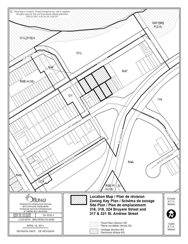
The subject lands are comprised of four
separate parcels of land, known as 316 to 324 Bruyère Street and 371 to 321 St.
Andrew Street. The subject lands form a T-shape with frontage on Bruyère Street
as well as on St. Andrew Street.
The property at 316 Bruyère Street contains a
single detached dwelling, the property at 318-320 Bruyère Street currently
contains an existing 2.5‑storey apartment building, and the properties at
324 to 334 Bruyère Street consist of a two‑storey row house. The
properties which front onto St. Andrew Street contain an existing two-storey
single detached dwelling and an existing duplex. The properties at 324 (324‑334) Bruyère
Street and 317 to 321 St. Andrew Street are on the Heritage Reference
List.
The surrounding land uses are a mix of residential uses, primarily two-to-three-storey low-rise buildings, ranging from single detached dwellings, semi-detached dwellings and townhouses. The built form in the area is predominantly low-rise residential. To the east of the property are vacant lands. To the north is Bordeleau Park which extends to the Ottawa River and further northwest abutting King Edward Avenue. To the west is Rose Park, a small parkette at the corner of Rose Street and Bruyère Street. On the north side of St. Andrew Street are a mixture of townhouses and semi-detached dwellings. Further to the northwest and southwest are two-to-three-storey residential use buildings. St. Andrew Street and Bruyère Street are defined as local roads in the city’s Official Plan.
A Site Plan Control application is required to facilitate the construction of the proposed development and the applicant submitted a corresponding site plan control application which reflects the requested Zoning By-law Amendment.
The original Zoning By-law Amendment and Site Plan Control proposed an eight-storey building fronting onto Bruyère Street with a three-storey, three-unit townhouse fronting onto St. Andrew Street. The applicant has since modified the proposal as a result of community consultation and consultation with staff. The proposal has been reduced to a five-storey residential building, and has added one additional property (317 St. Andrew Street) to the application.
Proposed Development Concept
The proposed development consists
of a 101-unit residential apartment building with a building height of five
storeys (16.5 metres) fronting onto Bruyère Street and onto St. Andrew Street. The
residential building is proposed to follow the configuration of the T-shaped
subject lands with vehicular access to the underground parking garage at the
east end of the site off Bruyère Street. Ground-oriented units are proposed
along both the Bruyère Street and St. Andrew Street frontages as well as
adjacent to Rose Park. The
proposal would involve demolishing the existing built form from the
intersection of Rose Street and Bruyère Street eastward to the vacant land at
346 Bruyère Street as well as demolishing the existing duplex and
semi-detached dwelling which front onto St. Andrew Street.
A site plan and 3D elevation of these revisions can be found in Documents 3 and 4.
Existing Zoning
The properties are currently zoned Residential
Fourth Density Zone (R4T) which permits a variety of low-rise residential uses,
from single detached dwellings to low-rise apartment dwellings. A low-rise
apartment building is defined as a building up to four storeys. There is a 14.5
metre height limit for low-rise apartment dwellings in the zone to accommodate
the recent trends of higher floor-to-ceiling heights within a low-rise
apartment building.
Purpose
of Zoning Amendment
With respect to the proposed five-storey residential building, the Zoning By-law Amendment proposes to rezone the lands to an R5N zone (Residential Fifth Density Zone) to permit a mid-rise apartment building. The proposal would require an exception to the R5N zone to permit site specific setbacks and a height limit which is discussed in detail in the following section.
The application consists of a 0.85-metre front yard setback along Bruyère Street and a 3.16‑metre front yard setback along St. Andrew Street. Along the St. Andrew Street frontage, the fifth storey is stepped back from the front by 2.0 metres. The interior side yards for the first 21 metres from Bruyère Street is proposed to be 1.5 metres. In addition, there is a proposed canopy projection along the Bruyère Street frontage which proposes to project up to the lot line abutting Bruyère Street.
Proposed Zoning
The Zoning By-law Amendment proposes to modify the zoning on the property as follows to accommodate the five-storey residential building:
- amend the R4T zone to an R5N zone, with a height exception limited to five storeys (16.5 metres);
- a site specific front yard setback along Bruyère Street of 0.85 metres;
- a site specific side yard setback for the first 21 metres from Bruyère Street of 1.5 metres; and
- a site specific provision to permit a canopy to project up to 0 metres to the lot line along Bruyère Street.
DISCUSSION
Planning Act and
Provincial Policy Statement
Section 2 of the Planning Act outlines those land use matters that are of provincial interest, to which all City planning decisions shall have regard. The provincial interests that apply to this site include the appropriate location of growth and development and the promotion of development that is designed to be sustainable to support public transit and to be oriented to pedestrians.
In addition, the Planning Act
requires that all City planning decisions be consistent with the Provincial
Policy Statement (PPS), a document that provides further policies on matters of
provincial interest related to land use development. The PPS contains policies
which indicate that there should be an appropriate mix of uses to
support strong, liveable and healthy communities.
The proposed zoning
allows for an increase of residential units, which will efficiently use land
and contribute to a balanced community. The site is located in proximity to two
arterial roads (King Edward Avenue and St. Patrick Street), which provide
access to the site. The site is conveniently located near residential and
commercial areas to allow for access by pedestrians and transit. The Department
is of
the opinion that the proposal is consistent with the matters of provincial
interest as outlined in the Planning Act and the PPS.
Official
Plan
Strategic Directions and Land Use Designation
Section 2.3.1 of the Official Plan sets broad
strategic directions to meet the challenge of managing growth and directing
growth to the urban area where services exist, providing infrastructure,
maintaining environmental integrity and creating livable communities within
The site is designated General Urban Area on Schedule B of Volume 1 of the Official Plan. The General Urban designation is intended to facilitate the development of complete and sustainable communities with a full range and choice of housing, in combination with conveniently located employment, retail, service, cultural, leisure, entertainment and institutional uses. The Official Plan supports infill development and intensification within the General Urban Area, provided it is developed in a manner that enhances and complements the desirable characteristics of the existing community and ensures its long term vitality. The Official Plan further requires that uses that serve wider parts of the city be located at the edges of neighbourhoods on roads where the needs of these land uses, such as transit, access and parking can be more easily met and their impacts controlled. The consideration of infill and intensification in the General Urban Area, the City will consider the following:
· recognize the importance of new development relating to existing community character so that it enhances and build upon desirable established patterns and built form;
· apply the policies of Sections 2.5.1 and 4.11;
· consider the contribution to the maintenance and achievement of a balance of housing types and tenures to provide a full range of housing for a variety of demographic profiles; and
· assess ground oriented multiple housing as one means of intensifying within established low-rise residential communities.
Section 2.2.3 “Managing Growth within the Urban
Area” provides direction for intensification in the General Urban area. Where a
Zoning By-law Amendment is required to facilitate intensification, the
appropriateness of the scale of development will be evaluated along with the
design and its compatibility. Additional cases such as the site being within
600 metres of a rapid-transit station; lands that are no longer viable for
their use; lands where the present use is maintained but additional uses can be
accommodated on the site; lands currently or formerly used as parking lots; or
lands where records indicate existing contamination, are also considered for
intensification.
The Department is of the opinion that the proposal satisfies the criteria of the General Urban Area with respect to the consideration of intensification. The proposal enhances and builds upon the established built form in the area. The proposal also satisfies the compatibility and design criteria of the Official Plan with respect to intensification. While the proposal is not within 600 metres of a transit station nor does it fall within any of the remaining criteria listed above with respect to Section 2.2.3, it is a modest increase in height and massing in comparison to what can be accommodated within the existing R4T zone.
The proposed five-storey
residential building provides an opportunity for additional residential units at
a scale and massing that supports the overall goals and policies of the
Official Plan’s Strategic Directions and General Urban designation.
Compatibility and Community Design
Section 2.5.1 of the Official Plan recognizes the importance of compatibility and community design when considering new development. The Official Plan recognizes in order for a development to be compatible, it does not necessarily have to be the same as, or similar to, the existing buildings in the vicinity. Rather, compatible development enhances an established community and coexists with existing development without causing undue adverse impact on surrounding properties. The Official Plan provides objective criteria to evaluate compatibility in Section 4.11.
Section 2.5.1 also addresses community design and acknowledges that good urban design and quality architecture can create lively places with distinctive character which provide tools to shape the environment. This section provides a set of design objectives and principles to be considered in evaluating development proposals. The design objectives include:
· enhancing a sense of community by creating distinct places;
· defining quality public and private spaces;
· creating spaces that are safe and accessible;
· ensuring that new development respects the character of existing areas;
· considering adaptability and diversity when creating spaces; and
· understanding and respecting natural processes and promoting environmental sustainability in development.
The Department is of the opinion that the proposed development satisfies Section 2.5.1. The Department is sensitive to the elimination of the existing building along Bruyère Street by this proposal and that the proposed building creates a new streetscape for the Bruyère Street frontage within the block between Rose Street and Forsey Street. The development, as proposed, is located with a front yard setback of 0.85 metres which is consistent with the existing front yard setbacks of the existing residential buildings along Bruyère Street. For those existing buildings located at 316 to 324 Bruyère Street, they encroach into the Bruyère right-of-way and in the case of 324 Bruyère Street the steps of all of the front porches of the buildings encroach onto the right-of-way. The design of the proposed building now responds to staff’s direction to the applicant to include ground-oriented units with direct access to the street for each unit, to be reflective of the multiple pedestrian accesses to the existing buildings along Bruyère Street. In addition, the multiple accesses provide an architectural relief along the Bruyère Street frontage.
The area is characterized by a mix of low-rise residential built form, and while the proposal is an increase to the existing height of the buildings in the immediate area, it is a modest increase and one that can be mitigated by the design of the proposed building with the ground-oriented units, the architectural delineation of the first two floors and the stepping back of the fifth floor along the St. Andrew Street frontage. In addition, Rose Park adjacent to the west provides buffering to the low-rise residential uses to the west.
As previously mentioned, Section 4.11of the Official Plan provides objective criteria to evaluate compatibility. The proposal was also reviewed in light of the criteria in Section 4.11 and the Transit-Oriented Design Guidelines. The following is an analysis of the applicable criteria, which demonstrates that the proposed development does satisfy the compatibility tests of the Official Plan.
Policy 1 of Section 4.11 recognizes that compatibility is not the only tool to evaluate development proposals, and that the City must have regard for the policies of Section 4.1 through 4.10, the objectives of Section 2.5.1, and the policies of any applicable Secondary Plans or site-specific policies. As previously discussed, the proposal meets the intent of the General Urban Area and satisfies the policies of the Strategic Directions as contained in the Official Plan. In addition, the Department is satisfied that the applicable policies contained in Sections 4.1 through to 4.10 are met.
Policy 2 of Section 4.11 acknowledges that not all of the objective criteria contained in the Official Plan are meant to be applicable to all circumstances; some may not apply, or may be evaluated and weighed on the basis of site circumstances.
Policy 2(a) requires that roads should be adequate to serve the development with sufficient capacity to accommodate the anticipated traffic generated by the development.
Vehicular access to the proposed building is from Bruyère Street via an underground parking garage entrance located at the easterly edge of the property which is proposed to provide parking for the residents and visitors of the five-storey residential building. A Community Transportation Study (CTS) was prepared in support of the application which has been reviewed by the Department. The Department had some comments and questions regarding the CTS and at the time of writing this report, the applicant was in the process of addressing the comments. The implementation of the CTS will occur through the Site Plan process.
Policy 2(b) requires that the vehicle ingress and egress to a development should address impacts such as noise, headlight glare and loss of privacy on development adjacent, or immediately opposite, to the subject property. The proposed garage entrance on the most easterly side of the proposed five-storey building, and this location is considered to have the least amount of impact in terms of pedestrian movement and the surrounding land uses including the adjacent parkette to the west of the site. In addition, the development will reduce the number of driveways along the Bruyère Street frontage from three to one. This will provide uninterrupted pedestrian movement from the intersection of Rose Street and Bruyère Street for approximately 60 metres. The proposal also results in the elimination of two of the existing driveways along the St. Andrew Street frontage which will also help to improve the pedestrian movement in the area. There is no vehicular access to the parking garage along the St. Andrew Street frontage, reducing any possible negative impacts to the existing residents on St. Andrew Street.
Policy 2(c) requires that a development should
have adequate on-site parking to minimize the potential for spill-over on
adjacent areas. Opportunities should be considered to reduce parking
requirements and promote increased usage of walking, cycling and transit,
particularly in the vicinity of transit stations or major transit stations in
accordance with Section 4.3. The proposal supplies the required amount of both
resident and visitor parking.
Policy 2(d) addresses building heights and massing
recognizing that new buildings should have regard for the area context, which
includes not only the massing and height of adjacent buildings but also the
planned function of the area. The desire for a transition in building heights
can be offset where natural buffers and setbacks exist or through the use of
appropriate design measures to create a more pedestrian-friendly environment.
With respect to the building height and massing,
the Department is of the opinion that the height and massing of the building meets
the intent of the planned function of the area. The subject lands are located
within the established low-rise residential area of Lowertown and the proposed
zoning is a modest increase in height, from the permitted 14.5 metres within
the R4T zone to 16.5 metres. A more pedestrian-friendly environment is achieved
through the design of the building with the ground-oriented units along each
street facade and a Bruyère Street front yard setback consistent with the
existing neighbourhood fabric. In addition, the vertical architectural features
break up the massing of the building to create a visual perspective that is
reflective of the neighbourhood’s built environment. The existing zoning in the
area includes R4T and R4F zoning which permits a variety of residential
dwelling types. As previously mentioned, the intent of the R4 zoning with a
height limit of 14.5 metres is to accommodate a low-rise apartment building
while recognizing that building trends are moving towards a greater floor to
ceiling height. Further to the northwest is an R5B H(16) zoning which also
permits a variety of residential dwelling types and contemplates a slightly higher
built form of 16 metres (five storeys).
The development proposes a 1.5 metre side yard
setback for both the easterly and westerly side yards for the first 21 metres
from Bruyère Street. Amenity spaces are proposed in the middle area of the
building with setbacks of 7.5 metres. With respect to the setbacks from St.
Andrew Street, a 3.05 metre front yard setback is proposed for the first four
storeys with the fifth story stepped back another 2.0 metres from St. Andrew
Street. The proposed 3.05 metre front yard setback is consistent with the
existing front yard setbacks of townhouses to the west. The existing
semi-detached dwelling and duplex dwelling which is to be demolished currently
has setbacks ranging from 0.55 metres to approximately 2.5 metres. The existing
townhouses adjacent to the east have a large front yard setback of 7.3 metres,
which is significantly larger than what the current zoning permits and provides
a buffer to the proposed building. The Department is of the opinion that these
setbacks, in conjunction with the proposed height of five storeys, and the
design of the building is compatible with the built form from the existing
built form on Bruyère or St. Andrew Street to satisfy policy 2(d).
Policy 2(e) recognizes the pattern of the
surrounding community and acknowledges that for development that proposes a
different height, building mass, proportion, street setback or distance between
buildings from the pattern of the area, the design of the proposed building may
compensate for this variation. The height of the proposed building is taller
than the surrounding buildings along St. Andrew Street; however the fifth
storey is stepped back 2.0 metres from the St. Andrew Street frontage which
reduces the impact of the height. It is staff’s opinion that the additional
height is modest in comparison to the permitted height of the R4T zone and the
existing three-storey townhouses which are adjacent to both the east and west
sides of the building along the St. Andrew Street frontage. In addition,
ground-oriented units and an additional entrance are proposed along the St.
Andrew Street frontage with the same architectural features as the Bruyère
Street facade.
The front yard setback of 3.05 metres proposed for
the St. Andrew Street frontage and the interior side yard setbacks of 2.5
metres for the first 21 metres provide a consistent street edge along St. Andrew
Street from Rose Street and sufficient side yards to neighbouring properties.
Policy 2(j) requires that the development should
minimize shadowing on adjacent properties, to the extent possible, through the
siting and design of buildings. Based on the location of the site, the majority
of the shadowing will occur on the north side of Bruyère Street in Bordeleau
Park. According to the applicant’s sun-shadow study, the proposed five-storey
building will have minimal effects on the shadowing of the park during the
summer, however in the winter months (December), there appears to be shadowing
of the park. The Department is of the opinion that the extent of the shadowing
of the park does not result in undue impacts.
Policy 2(l) requires that the development provide
supporting neighbourhood services, or alternatively, is able to be supported by
existing neighbourhood services. There are a number of services in the
immediate area that could support the proposed development.
Other design and compatibility criteria such as
noise, lighting, fencing, microclimate and loading areas are addressed through
the Site Plan Control process.
Official Plan Amendment 76
While Official Plan Amendment 76 is currently
under appeal and is not in full force and effect, the amendment was adopted by
City Council and thus is taken into consideration in the evaluation of planning
applications. When evaluating the appropriateness of a development proposal,
one of the main differences between the City of
One new policy is the consideration of whether the
design of a proposal takes advantage of opportunities to improve the character
and quality of an area and the way it functions. Other new policies appropriate for
consideration in a rezoning application are policies related to Building
Profile and Compatibility. Development proposals will also address issues of
compatibility and integration with surrounding land uses by ensuring an
effective transition in built form. This will serve to link the proposed
development with existing development.
In terms of height, Official Plan Amendment 76 defines a Mid-Rise as a
building of five to nine storeys. The policies recognize that integrating
taller buildings within an area characterized by a lower built form is an
important design consideration, especially in relation to intensification. The
policies further provide criteria to achieve a built form transition by:
a. Incremental changes in building height (e.g. angular planes or stepping
the building profile up or down);
b. Massing (e.g. inserting ground-oriented housing adjacent to the street
as part of a high-profile development or incorporating podiums along a
Mainstreet);
c. Character (e.g. scale and rhythm, exterior treatment, use of colour and
complementary building finishes);
d. Architectural design (e.g. the use of angular planes, cornice lines);
and
e. Building setbacks.
The Department satisfied that the proposal meets
the intent of policies of Official Plan Amendment 76. The building proposes an
incremental change in building height along the St. Andrew Street frontage and
also provides for ground-oriented units along both the St. Andrew Street and Bruyère
Street frontages.
Details of Proposed Zoning
The Zoning By-law
Amendment application requests to change the existing R4T zoning to an R5N zone
with site specific provisions to permit a mid-rise apartment building (five storeys),
with a height limit of 16.5 metres, a setback to Bruyère Street of 0.85 metres,
a canopy projection of 0 metres and 1.5 metre side yard setbacks for the first
21 metres from Bruyère Street.
Servicing Issues
A servicing study was
provided in conjunction with the development application. The Department has
reviewed the study and has no issues with the findings with respect to
capacity. Further detailed review will
be undertaken as part of the Site Plan Control process.
Concurrent Application
As previously mentioned, a Site Plan Control application has been submitted which reflects the building elevations and site plan submitted with the Zoning By-law amendment application. If approved, the Site Plan Control application would implement the development.
Summary
In summary, the proposed Zoning By-law Amendment supports the direction of the Planning Act, Provincial Policy Statement and Strategic Directions of the Official Plan. The mid-rise residential development is a modest increase to the height of the existing zoning and the resulting development has satisfactorily addressed the compatibility and design criteria as well as transportation and servicing criteria.
ENVIRONMENTAL IMPLICATIONS
A Phase I Environmental Site Assessment was submitted as part of the Zoning By-law Amendment application. No significant issues were identified in the Phase I ESA.
RURAL IMPLICATIONS
N/A
CONSULTATION
Notice of this application was carried out in accordance with the City’s Public Notification and Consultation Policy. The Department received numerous comments from the public and community groups which are included in Document 5.
LEGAL IMPLICATIONS
Should this matter be appealed to the Ontario Municipal Board, it is anticipated that a three-day hearing would result. If the recommendation is approved and the matter appealed, it is expected that the case could be conducted within staff resources. If the rezoning is refused, reasons must be provided. The City would need to retain an external planner to provide opinion evidence in support of the position of Council It is estimated that the cost that would be incurred by the City would be in the range of $20,000 to $25,000.
RISK MANAGEMENT IMPLICATIONS
N/A
CITY STRATEGIC PLAN
The proposed development and planning application is aligned with the City Strategic Plan in that it respects the existing urban fabric or neighbourhood form so that new growth is integrated seamlessly with established communities.
TECHNICAL IMPLICATIONS
FINANCIAL IMPLICATIONS
If the rezoning is refused, the City would need to retain an external planner to provide opinion evidence in support of the position of Council. It is estimated to be in the range of $20,000 to $25,000. Funds are not budgeted for external planning consultants; the expense may impact Planning and Growth Management’s 2011 operating status.
APPLICATION PROCESS TIMELINE STATUS
This application was not processed by the “On Time Decision Date” established for the processing of Zoning By-law Amendment applications as the applicant was required to address staff’s comments.
SUPPORTING DOCUMENTATION
Document 1 Location Map
Document 2 Details of Recommended Zoning
Document 3 Proposed Site Plan
Document 4 3D Elevations
Document 5 Consultation
Details
DISPOSITION
City Clerk and Solicitor Department, Legislative Services to notify the owner, applicant, OttawaScene.com, 174 Colonnade Road, Unit #33, Ottawa, ON K2E 7J5, Ghislain Lamarche, Program Manager, Assessment, Financial Services Branch (Mail Code: 26-76) of City Council’s decision.
Planning and Growth Management to prepare the implementing by-law, forward to Legal Services and undertake the statutory notification.
Legal Services to forward the implementing by-law to City Council.
LOCATION MAP DOCUMENT
1
DETAILS OF RECOMMENDED ZONING DOCUMENT 2
Proposed
Changes to the Comprehensive Zoning By-law
1. The Zoning Map of City of Ottawa Zoning By-law 2008-250 is amended by changing the zoning of the lands known municipally as 316, 318, 324 Bruyère Street and 317, 321 St. Andrew Street from R4T (Residential Fourth Density Zone, Subzone T) to R5N [xxxx] (Residential Fifth Density Zone, Subzone N, Exception xxxx);
2. Add a new exception [xxxx]
in Section 239 as follows:
Column V: Provisions:
a. the maximum height and number of storeys for an apartment dwelling, mid-high rise is 16.5 metres and 5 storeys
b. the minimum yard setback from the Bruyere Street lot line is 0.85 metres
c. notwithstanding Section 65, a canopy is permitted to project up to the rear lot line
d. the minimum side yard setback for an apartment dwelling, mid-high rise for the first 21 metres from Bruyere Street is 1.5 metres
PROPOSED SITE PLAN DOCUMENT 3
PROPOSED 3-D ELEVATION DOCUMENT
4
CONSULTATION DETAILS DOCUMENT
5
NOTIFICATION AND CONSULTATION PROCESS
Notification and public consultation was undertaken in accordance with the Public Notification and Public Consultation Policy approved by City Council for Zoning By-law amendments.
PUBLIC COMMENTS
There were many members of the public who provided comments on this application. Owing to the large amount of public input, including a submission signed by 50 members of the public (Bruyère Task Force) and numerous other submissions by smaller groups, the comments have been categorized to avoid repetition in the comments and the staff response. A summary of the public comments and staff response are provided below.
SUMMARY OF PUBLIC INPUT
Comment:
HEIGHT/MASS/SCALE:
· The sheer size (height and width) of the proposed building on Bruyère is incompatible with the low rise neighbourhood surrounding it
- The proposed setback, does not adequately address the massing issue that will be left by the bulk of the building.
- The features of this proposed building are out of line with the already impressive density within this small area. The affected community has already intensified significantly, adding density in innovative low-rise architecture primarily within the existing zoning.
- Nowhere in
Lowertown or Sandy Hill is there a building so completely unrelated to the
scale and nature of the surrounding development, which conform to R4
zoning at heights of one to three storeys and offer a variety of physical
forms, prices and ownership types.
- Exceeding four
storeys would drastically alter the community.
- The footprint
of the five-storey option is even bigger than the eight-storey option, and
will require the demolition of more buildings.
- The proposed
building is out of scale and out of character for the community
- Anything over
four storeys (the current zoning) would negatively alter the character and
skyline of the community
Staff Response:
The Department is of the opinion that the proposed development is compatible with the surrounding low-rise residential area and that the proposed Zoning By-law Amendment does satisfy the policies of the Official Plan or the PPS. Details regarding the Department’s position are contained in the body of this report.
Comment:
TRAFFIC
- The ingress for the new residents would see Bruyère used as the almost exclusive ingress point due to traffic control established at Forsey/St. Patrick and St. Andrew and St. Patrick.
- Even if traffic entered from all the streets (Guigues, St. Andrew, Bruyère or Cathcart), all cars would be funnelled through the intersection of Bruyère and Rose. This intersection is the only intersection through which pedestrians and dogs enter Bordeleau Park that has become the core of our community.
- Dozens of individuals who work at the Department of Foreign Affairs already park on the neighbourhood streets, leaving it very difficult for neighbours to have on-street parking for visitors. In addition, the park is very well used, particularly in the summer, by dozens of people using the soccer field, the playground or the tennis courts. This situation creates a potential safety concern. The current on-street parking hampers the ability of emergency vehicles (e.g., fire trucks, ambulances, as well as snow removal apparatus) to enter our community, especially in winter.
- In considering this proposal, the City must consider the impact on the community of traffic due to the eventual redevelopment of the property currently owned by the Government of Iraq (346 Bruyère). Currently, the Chinese Embassy operations during working hours impacts traffic on St. Patrick.
- The impact of the additional cars on King Edward and St. Patrick has not been fully assessed by the developer. The negative impact inside the enclave is clear. However, any additional traffic on those roads at peak times would add to an already contentious urban issue.
Staff Response:
As noted in the body of the report, the Department has outstanding comments with respect to the submitted Community Transportation Study, which are currently being addressed and any recommendations from the study will be further addressed in the Site Plan agreement. The issue of parking from other uses in the area can be addressed through Parking Enforcement and an evaluation of the on-street parking restrictions in an area is not part of a Zoning By-law Amendment application. The applicant is proposing a total of 133 parking spaces for the residents and visitors which exceeds the minimum requirements of the Zoning By-law.
Comment:
GEOTECHNICAL
- Dewatering impacts have not been fully addressed relative to the shoreline, the development’s foundation and foundations nearby. There are several concrete examples of how dewatering and blasting have impacted the foundations of this neighbourhood. In addition, due to the clay-based riverbed nature of the land in this area, several homes are already experiencing significant stress on their foundations as the clay continues to settle.
· Micro-site blasting has not been fully assessed for the impacts it will have on stone and sand foundations. Any blasting that will occur must have area foundations assessed by an engineer, paid for by the developer but sourced by the homeowner to set baseline structural competencies.
- The Elevations show no parking details i.e. no elevation details below grade. Structures with windows are shown on the roof above the third storey level. Does this provide access to the roof? If roof decks are envisioned, they will be incongruous with the neighbourhood.
· The parking structure will be below the level of the Rideau River. What are the implications and where will infiltrating water be directed?
· The consultant notes that “if there are more than two levels of parking” where the program states that there will be three levels of parking. All studies should be based on the assumption that there will be three levels of parking. Assessment of the foundation cannot be undertaken until the number of levels of parking are confirmed as geological strata and engineering properties vary with depth.
Staff Response:
The
proposal intends to accommodate the required parking in an underground parking
garage. The parking garage is proposed to accommodate 110 parking spaces
(residential and visitor). With respect to the dewatering or blasting of the
site, these are issues which would be addressed at the Site Plan Control stage.
In addition, Rideau Valley
Conservation Authority has been circulated the application and has provided the
following comments regarding the proposal:
“This development is not within the 1:100 year
floodplain of the Rideau River, however the city should ensure that protection
is in place relating to the Stormwater and drainage system so that no storm
sewer surcharging or flooding would occur as a result of the nearby Rideau
River reaching 55.71 metres geodetic, the 1:100 flood elevation.”
Comment:
PRECEDENT
- Approval of this request for re-zoning for an increased height limit and decreased setbacks would reverse a policy that has served the non-commercial area of Lowertown well for the last 35 years. If permitted, this change will serve as a precedent for applications from other sites in the immediate area including:
· the large vacant land adjacent to the proposed site on Bruyère Street;
· a parcel of land having small older houses similar to that at 316 Bruyère which are adjacent to an empty lot from 285 to 395 St. Andrew Street;
· other lots with smaller, older structures in the immediate vicinity west of King Edward Ave.
Staff Response:
Each planning application is reviewed on its own merits. The Department recognizes that there are properties within the vicinity of the subject property that could be re-developed however, each application will be evaluated at that time independently of any other planning applications in the area.
Comment:
HERITAGE
As part of the community’s submission, a document entitled Lowertown East Our Disappearing Heritage which was reviewed by Heritage Services. In addition, there are these following comments received regarding heritage concerns:
· I'm worried about the demolition of the heritage house on the corner of Rose and Bruyère. I believe the house is 140 years old. What is the city of Ottawa doing to safeguard this type of heritage?
· There has been no effort to incorporate heritage buildings
· There is no respect for the diverse historical and current built substance of the neighbourhood
· There is no effort to maintain, compliment or reflect heritage
- The proposal makes no effort to incorporate heritage buildings
- Although Lowertown East is not designated as a heritage area, there a number of old houses. Among those that will be demolished are early 20th century homes. Instead of respecting the historic value of the neighbourhood, the developer says it aims to “incorporate elements of the heritage character” of the neighbourhood. We respectfully disagree with this assessment, since the six brick houses that will be demolished are much more indicative of the heritage character than the proposed building is. The same could be said about 321 St-Andrew St.
· 324-334 Bruyere is a unique Victorian six unit rowhouse built in 1910 – making it by definition a heritage property; this building must be saved.
· The proposal would essentially gut what may be the most complete block of historic housing left in the neighbourhood.
Staff Response:
Heritage Staff were consulted at the pre-consultation stage as well as during the circulation of this Zoning By-law Amendment application. Heritage Staff have not identified any heritage significance pertaining to the existing structures on the subject lands that would warrant designating the building under Part IV of the Ontario Heritage Act. Below is the comment received from Heritage Services. The Department has consulted the applicant on the suggestion by Heritage Services that a commemorative plaque be placed in one of the adjacent parks to describe the history of Lowertown. The applicant has agreed to this suggestion and details of the plaque will be addressed at the Site Plan Control stage and detailed in the Site Plan agreement.
Heritage Services comments:
The properties proposed for demolition as
part of this development application have undergone a number of unsympathetic
alterations over time. A brief description follows:
321 St. Andrew The integrity of the brick has been damaged
by several layers of paint. The slumping of brick on the front elevation
indicates some structural distress. The decorative star motif above the windows
described in the report Lowertown
East Our Disappearing Heritage by the Lowertown Community
Association and Bruyere Street Task Force, April 2011, is a common design
evident in other Lowertown buildings such as 236-238 Cathcart. The front porch,
original windows, doors and end brackets in the roof cornice have been removed.
316 Bruyere has undergone similar alterations with newer sheathing throughout.
324-334 Bruyere There is a visible wave in the building apparent
in the roofline when seen from across the street. This is an indication of some
structural movement. The building retains its original cornice and the brick
appears in fair to good condition. This is not a rare building type for
Lowertown as a whole.
317-319 St. Andrew This double-gabled dwelling is currently
covered with siding. The historic photo in the report Lowertown East Our Disappearing Heritage illustrates a number of
changes to the building including different openings on the ground floor, loss
of porch etc. Only the general form of the original building remains.
Conclusion
In summary, the alterations to the original
buildings have compromised their design character and significance. There is
also a degree of structural distress evident in some of the buildings. The
historic streetscape context has also been largely lost in this block with the
exception of the east side of Rose Street which contains two flat-roofed brick
doubles in good condition.
Recommendations
Whereas the retention of these buildings may
not be warranted, they should be photo-documented prior to demolition. The
bricks on the row at 324-334 Bruyere should be recycled. The applicant could be
requested to fund a commemorative plaque in one of the adjacent parks to
describe the history of Lowertown East as a condition of Site Plan Approval.
The Lowertown Community Association could be encouraged to update the Heritage
Reference List for the neighbourhood to enable an accurate inventory of
remaining older buildings in the area. In terms of the rezoning, there is
nothing in the area higher than three storeys so the proposed development would
be higher than existing properties in this block and the Lowertown East
neighbourhood.
Comment:
CITY PARK AND SUN-SHADOW STUDY
· The enormous bulk of the proposed building will create a massive barrier that will produce a sun shadow during many parts of the day over the year. This park that will be overshadowed currently supports year-round activities including soccer and picnics in summer, snowshoeing and cross-country skiing in winter.
- Early morning studies and late day studies have not been provided. Shadows will have significant impact on Bordeleau in the fall, winter and spring when the sun’s angle is low. More complete shade studies will show that much of the park will be in shadow during this time of the year, and that shadows will reach across the park to neighbouring properties in the early morning and evening.
- This is a very small community which is united by Bordeleau Park, directly across the street from the proposed eight-storey building. Lowertown East is contained by the damaging traffic of King Edward Avenue and St. Patrick Street, it is crucial that the park be safe guarded as jewel in this community. The park will be shadowed once the building is completed.
- Noise from air conditioning and heating will detract from park ambience and possibly endanger wildlife.
Staff Response:
The Department has not identified a concern regarding the shadowing impacts of the five-storey building on the existing park. The Department is the opinion that the sun shadow impact to the park that primarily occurs during the winter months will not result in undue or adverse impacts to the park.
Comment:
SITE DESIGN/SITE FUNCTIONING ISSUES
- Proposed building will remove its occupants from the kind of street level activities that enhance overall neighbourhood safety and the feelings of security
- The design discourages people interactions in an area of homes/rowhouses/walk-ups with doors opening at streetside
- The design encourages entry into and out of an underground garage
- Special attention should be paid to the noise generated HVAC equipment
- Small setbacks on Rose St. and St. Andrew St. are not typical of the area and do not justify the lack of setbacks on this proposal
- No discussion of what the living environment will be like for the units located within the inside corners of the “T”
- The developer has not adequately described how they will manage waste produced by the condominium units. We anticipate it would necessitate additional heavy truck traffic on the street on a weekly basis at the very least and may also include unsightly garbage bins visible to the neighbours. Also as noted above, the daily on-street parking by both existing residents as well as DFAIT employees will make it very difficult to navigate other servicing traffic (i.e. moving vans, delivery trucks, etc.)
- With any new building of the size proposed by Claridge, Bordeleau Park would be lit at all times. The building would be unavoidable under any circumstances, but even the dark would not hide its mass due to the large amount of proposed units with exterior as well as interior lighting.
- There is no indication of how the developer would mitigate the effects of construction on the neighbourhood. We assume that in order to construct there will be significant blasting, trucks and other equipment coming through, staying on site etc. Given the size of the development and the absence of an open space to put equipment, where will that equipment be kept? How will it be moved? What is the compensation regime for any damage caused by the construction (do we have to go through the normal civil courts with the resulting time and money, or is there some expedited process?)
- Our fourplex was originally a double built in 1898, to which an addition was added in 1956. We were in the process of planning exhaustive renovations to the place as it is in need of an overhaul. What were motivating those renovations were, in part, the decaying foundations and the weaker walls of the addition. I am not an engineer but I can say that no blasting (for the lower levels of the parking) can be undertaken until an engineer has come in to do an inspection. In fact, we highly doubt that the foundations of the addition (which stand on clay and not cement) can withstand controlled blasting as it is located about 12 metres from the back lot line. As landlords and residents, our fear is both for the solidity of our residence, but also for the safety of the tenants and of ourselves.
Staff Response:
With respect to the design, ground-oriented units are proposed along the Bruyère Street frontage and the frontage of Rose Park to encourage pedestrian interaction. The setback proposed along Bruyère Street is similar to the setbacks of the existing buildings. The setback proposed along St. Andrew Street is similar to the existing buildings along St. Andrew Street. Further discussion regarding the design is found in the body of the report.
Construction methods are not considered through the Zoning By-law amendment process, the issues identified pertaining to construction would be addressed at the Site Plan Control stage and Building Permit process stage. If development were to proceed, the applicant would have to store the construction vehicles on-site or off-site in accordance with the City’s regulations. The Site Plan Control application is currently on hold until a decision regarding the Zoning By-law Amendment has been made by City Council. If the Zoning By-law Amendment application is approved, the Site Plan Control process would continue and at that time the issues of de-watering, blasting and construction issues would be addressed.
The
City’s Noise Control Study guidelines establish when such a study is required, mid-rise
housing do not generate a noise level that would necessitate a Noise Control
Study.
Comment:
SERVICING
· Claridge did not provide any assessment of how the condominium units will impact existing infrastructure.
Staff Response:
The Zoning By-law Amendment application included a servicing study which indicates that there are no servicing issues for the proposed development.
Comment:
ENVIRONMENTAL DESIGN
- Claridge’s plan does not advance an environmental agenda. There are no plans for LEED standards or offsetting of any kind. Moreover, they have not presented options for sustainable development using reclaimed or locally sourced materials.
- Increase in people but decrease in open space
- Decreases existing green landscaping
- Shows little sign of energy conservations intelligence (northern exposure, etc.)
Staff Response:
There are currently no requirements for a proposed development to meet any of the LEED building standards or sustainable design.
Comment:
HOUSING
· While the proposed development will increase population density in the area, the proposed sizes and configuration of the apartments suggest the building will not attract many families— and few, if any, young families.
· The residents who will lose their homes because of the demolition are unlikely to be housed in the new building.
· Although this proposal is for a condominium-type ownership structure, 25% of downtown condo units are purchased as rental units. The people who will buy/rent these units will most likely be students or young singles/couples who are just passing through a stage in their life before moving on.
Staff Response:
The Department encourages a mix
of housing in each new development proposal however there is no mechanism to
require an applicant to provide a certain ratio of one, two and three-bedroom
units in a residential building.
Comment:
INTENSIFICATION/COMPATIBILITY
- We support an incremental approach to infill and we acknowledge there is great potential to first build to current standards before rezoning for larger, out of scale projects.
- The proposal represents intensification of more than fivefold from less than 20 families to more than 100.
- Any intensification should be consistent with and strengthen the current livability of the neighbourhood through the promotion of pedestrian-friendly entrances that bring people onto the street and into our parks.
- The Claridge proposal presents a scenario of overdevelopment that will disrupt a stable residential neighbourhood. While a more compact city is a necessary and valuable goal, any intensification must avoid producing serious drawbacks while maximizing potential benefits.
- Many intensification projects have been undertaken in the immediate area under the existing by-laws.
- We want to stress that we are not against intensification in the Lowertown area. If this developer wants to demolish the houses to build condos that respect the zoning limits, we may find it regrettable from a heritage perspective, but it remains the prerogative of the owner. However, we are strongly opposed to any zoning amendments and we question the setbacks for which Claridge is applying.
Staff Response:
The Department is of the opinion that the existing R4T zoning can provide opportunities for redevelopment however this proposal is a modest increase in the height and reductions of setbacks and thus the impacts between the existing potential development of these properties in the R4T zone and what is proposed is acceptable. A detailed discussion regarding the proposal in relation to intensification and compatibility is contained in the body of this report.
Comment:
- There is nothing that we saw in the proposal to provide something back to the neighbours (including our family) who will face greater stress and usage in community amenities, such as use of the park, traffic on the street, more limited parking spaces for guests, etc. Frankly, we would have preferred a mixed commercial-residential use that might have had a coffee shop, yoga studio, etc. incorporated into it. It seems to us part of the advantage of densification and the set-off for increased use of the park (not to say the shading of it) should be increased amenities.
Staff Response:
The proposal has not included any non-residential uses however the Department notes that the General Urban designation does contemplate the inclusion of some mixed uses in residential buildings.
COMMUNITY ORGANIZATION COMMENTS
LOWERTOWN COMMUNITY ASSOCIATION
On behalf of the Lowertown Community Association, I respectfully submit the following views relating to the most recent Zoning By-law Amendment and Site Plan control application for the 5-storey condominium development on 316-330 Bruyère Street.
We appreciate that the proposal has been revised to better fit, in terms of height, with the surrounding community and that the developer accepted to present it to area residents at one of our monthly community meetings. However, we are concerned that the proposal does not meet current zoning bylaws and by the precedent we believe this would set for future developments in our community. Further, I would highlight that a large group of residents have indicated that the development would involve the demolition of buildings which they perceive as having important heritage value to the community and that the proposed development does not seek to maintain them or reflect their architecture. On a related note, we would like to draw your attention to the attached heritage report developed by area residents which explains that there is heritage value in that part of Lowertown that is not appropriately recognized in the city's plan. Let me take the opportunity to express my appreciation again for your engagement with the community on this matter.
Principles by the Lowertown Community Association
- We are open to new residential developments in our community.
- We urge developers to propose developments that meet existing bylaws (e.g. regarding building height) and are very concerned with the precedent that could be set by changing these bylaws.
- Proposed developments should seek to fit in the existing community both in terms of size and in terms of architecture.
- We are concerned with developments that involve the demolition of buildings with heritage value to the community.
- We encourage developers to make a certain proportion of their development affordable housing and stress the importance of ensuring that residents are not forced out of our community.
- We are open to working with developers to seek solutions and incentivize best practices that are amenable to the community - including promoting developments that are in line with the character of the neighbourhood and that meet the highest standards for energy efficiency and sustainable building practices.
- We support the residents’ initiative (led by William Murray) to organize and express their views on the proposed development on 316-330 Bruyère street
Staff Response:
The issues raised by the Community Association have been addressed in the body of the report and in the staff responses to issues that were raised by the public comments.