Report
to/Rapport au :
Planning Committee
Comité
de l’urbanisme
and
Council / et au Conseil
01 September 2011 / le 1ier
septembre 2011
Submitted
by/Soumis par : Nancy Schepers, Deputy City Manager/Directrice municipale adjointe,
Infrastructure Services and Community Sustainability/Services d’infrastructure
et Viabilité des collectivités
Contact
Person/Personne-ressource : Richard Kilstrom, Manager/Gestionnaire, Policy
Development and Urban Design/ Élaboration de la
politique et conception urbaine
Planning
and Growth Management/Urbanisme et Gestion de la croissance
(613) 580-2424
ext.22653, richard.kilstrom@ottawa.ca
City Wide /
À l’échelle de la ville Ref N°:
ACS2011-ICS-PGM-0187
|
SUBJECT:
|
Recommended council position for
urban boundary phase 2 ontario municipal board
|
|
OBJET :
|
POsition recommandée du conseil concernant
la limite du secteur urbain – phase 2 - commission des affaires municipales
de l’ONtario
|
REPORT RECOMMENDATIONS
That Planning Committee recommend that Council
approve:
1.
The parcels shown in Document 3
as Schedules R36, R37, and R38 and Revised Schedule R34 to form the balance of
the urban area expansion; and
2.
An amendment to the Urban Tree
Conservation By-law, By-law 2009-200, effective 28 September 2011, extending
the application of the by-law to the parcels recommended to be added to the urban
area.
RecommandationS du rapport
Que le Comité de l’urbanisme
recommande au Conseil d’approuver :
1.
La présentation à la Commission des
affaires municipales de l’Ontario des parcelles illustrées comme annexes R36,
R37, R38 et annexe révisée R34 dans le document 3 pour constituer le reste de l’expansion
du secteur urbain;
2.
D’adopter une modification au Règlement
2009-200 sur la conservation des arbres urbains devant entrer en vigueur le 28
septembre 2011 et ayant pour effet d’étendre l’application du règlement aux
parcelles qu’il est recommandé d’ajouter au secteur urbain.
Background
On June 3, 2011 the Ontario
Municipal Board (OMB) released its decision on the Phase 1 urban boundary
appeals under Official Plan Amendment No. 76 (OPA 76). The decision concluded
that 850 gross hectares is the appropriate amount of land for urban expansion
to accommodate residential growth to 2031. The Board gave significant weight to
the Official Plan review process completed by the City in 2009. The upcoming Phase
2 OMB hearing will deal with what specific lands will form the urban expansion.
On July 4, 2011 Planning Committee
considered Report ACS-2011-ICS-PGM-0153
dated June 24, 2011 on the recommended process to establish Council’s position for
the Phase 2 hearing on lands to be added to the City’s urban area. On July 13,
2011, Council approved the process outlined in Document 1 of the Planning
Committee report. This process carries forward staff’s approach to analysis of
potential expansion areas, which evaluated potential areas based on a series of
criteria, subject to any new information that had become available since the
May 2009 evaluation.
The purpose of this report is to:
1.
Provide an update of the parcel scores with identified new information;
2.
Recommend to Planning Committee and Council what lands should be
supported as the 850 gross hectares of urban area expansion; and
3.
Recommend that Planning Committee and Council extend the application of
the City’s tree preservation by-law to the lands recommended for urban area
expansion.
DISCUSSION
Recommendation 1
The Board’s June 3, 2011 decision
determined that the process and methods used by the City throughout the 2009 Official
Plan review were sound. Therefore, subject to review of any new information,
the analysis undertaken for the 2009 Official Plan review forms the basis of
City’s position for Phase 2 of the urban boundary hearing.
The process of evaluating
potential areas for urban expansion in May 2009 identified candidate areas
based on five selection criteria then evaluated them relative to each other
based on 16 criteria as detailed in Document 6 of report ACS2009-ICS-PLA-0080
dated May 4, 2009. From July 13, 2011 to August 12, 2011, staff consulted with
landowners regarding any new information relevant to updating the evaluation of
candidate parcels. The correction of minor errors is considered new
information. There was no change to the criteria or method of analysis.
Although requests were received to include other parcels, no new parcels were included
in the detailed analysis. This was because either the lands were designated
Agricultural Resource Area in the Official Plan, and were therefore excluded,
or because they were not close to scoring well enough to be recommended.
The top ranked areas that
cumulatively add to 850 gross developable hectares are those parcels that will
form the City’s position on what lands are to be added to the urban area at the
Phase 2 hearing. Based on the evaluation of new information, the only change to what staff recommended in
2009 for lands to be added to the urban area is to include a small parcel (1bE)
at the north end of Kanata and to exclude an adjacent parcel (1cW). That has
the effect of increasing the recommended land area from the 842.6 hectares
recommended in 2009 to 851.9 hectares in this report, an additional 9.3
hectares. Although the recommended addition is 1.9 hectares above the figure
named in the OMB decision it is not considered significant, especially given
that the estimates of developable land in each parcel did not take account of
required setbacks from the edge of slopes watercourses and the like. When more
detailed planning is undertaken, the actual amount of developable land will be less
than 850 gross hectares.
The 851.9 hectares include 163
hectares in the Fernbank area added by OPA 77 (candidate areas 5a and 5b) and
67 hectares south of Fernbank (parcels 6a, 6b and 6c), which together are the
230 hectares Council adopted as the OPA 76 urban expansion on June 10, 2009.
Details of the review of information and revised scoring are
contained in attached Documents 1 and 2. Map schedules of the recommended
parcels, other than those contained in OPA 76, are provided in Document 3.
Recommendation 2
The Ontario
Municipal Board, in its consideration of the first Urban Boundary Hearing also proposed
approval of the policies that would apply to the new urban expansion areas and
define how these areas will be developed. The two new Sections (3.12 Urban
Expansion Study Area and 3.13 Developing Community (Expansion Area)) contain
policies that require the identification and protection of lands that form part
of the natural heritage system. The policies require that these areas, which
contain significant tree cover, are to be conveyed to the City. In
anticipation of these areas becoming urban, it is important that these natural
features are left intact.
At present the only method that
the City has to regulate tree removal on private land is the City’s Urban Tree Conservation
By-law that only applies to the urban area and candidate urban Area 11 (added as
a result of the 2009 tree clearing in that area). The By-Law does not apply to
the remaining candidate areas for urban expansion. Consequently, it is
recommended that the application of the Urban Tree Conservation By-law 2009-200
be extended to protect the balance of candidate urban lands recommended by this
report.
In 2009, Council adopted the
staff recommendation to allocate nine per cent of dwelling units and ten per
cent of population growth to the rural area. All parties during the Phase 1 urban
boundary appeal also agreed to this allocation. The recommendations contained
in this report will seek to redesignate lands from the rural area to the urban area
at the upcoming Phase 2 hearing.
CONSULTATION
Landowners for
the candidate areas were consulted through the end of July up to August 12,
2011. Staff also received submissions and responded to questions from
non-candidate landowners.
Comments by the Ward Councillor(s)
N/A
LEGAL IMPLICATIONS
The
Ontario Municipal Board has set down the date of October 19th, 2011 for a
pre-hearing with respect to the Urban Boundary Phase 2 matter. Only after
Council considers the present report on September 28th, 2011 will it be known
with certainly if a phase 2 hearing will be required. The extent of the hearing
will turn on the number, if any, of the appellants to Official Plan Amendment
76 who wish to challenge Council’s determination as to which lands are to be
added to the Urban Area. It is anticipated that any hearing on this matter
would be in February/March, 2012. The hearing will be conducted by staff within
Legal Services. Should this report be adopted by Council, it is also
anticipated that all of the City’s witnesses would be staff.
RISK
MANAGEMENT IMPLICATIONS
Risks have been identified and explained in the Legal
Implications section.
There are no financial
implications. Should an Ontario Municipal Board hearing be required, the
hearing would be conducted by Legal Services staff, and all of the City’s
witnesses would be staff.
Environmental Implications
The environmental
aspects of the candidate parcels for addition to the Urban Area were analyzed
as part of the process prior to the adoption of OPA 76. Proposed policies in
the amendment provide for natural heritage system lands in each area to be
transferred to the City for $1.
The report
recomends that the City’s Urban Tree Conservation By-law be extended to apply
to the candidate areas recommended by this report to ensure the protection of
those lands with natural heritage values.
Technology Implications
N/A
City Strategic Plan
This report supports Planning and
Growth Management priorities to manage growth and create sustainable
communities and to ensure that the City infrastructure required for new growth
is built or improved as needed to serve that growth.
SUPPORTING DOCUMENTATION
Document 1 Candidate Area New
Information
Document 2 Urban Expansion
Areas – Review of Candidate Areas including New Information
Document 3 Recommended Parcels
for Urban Expansion
DISPOSITION
The
recommendations contained in this report are to form Council’s position for
lands to be added to the Urban Area at the upcoming Urban Boundary Appeals,
Phase 2 Ontario Municipal Board hearing.
The
Legal Branch is to bring forward an amendment to the Urban Tree Conservation
By-law for Council adoption on 28th September 2011.
Candidate Area New Information DOCUMENT
1
The
analysis undertaken in 2009 was reviewed and updated based on available new
information. The update resulted to a change to two land parcels in north
Kanata, including one and excluding the other, but otherwise did not alter the
2009 staff recommendation for lands to be included in the urban area.
As
instructed by Council, the General Manager of Planning and Growth Management
notified all those people who had made submissions to the City in respect to
OPA 76 of the opportunity to make further submissions on the candidate lands
for urban expansion. The letters went out on July 21st and advised
that the City would receive and consider any new or updated information that
may have bearing on the staff evaluation undertaken in 2009 of the candidate
lands for urban expansion.
In
response to the request for new information relevant to the parcel evaluation,
a number of submissions were received by the August 12th, 2011
deadline for submissions. A list of these submissions is provided in the following
table. Several submissions related to lands that were not included in the 2009
evaluation, either due to their location, because the land was designated
Agricultural Resource Area in the Official Plan, or other factors that made the
land unsuitable candidates. In general, little relevant new information was
provided by the submissions.
List of Submissions Received
|
Submitter
|
Area / Parcel #
|
Staff Note
|
|
Comments on Evaluated Parcels:
|
|
|
|
Novatech Engineering
|
1a, 1cE, 1cW, 1d, 1h
|
|
|
Metcalfe Realty c/o Lloyd
Phillips & Assoc.
|
1b & 1c
|
|
|
Thom van Eeghen
|
1e
|
|
|
Jim Maxwell
|
South portion of 1f
|
|
|
Paul Renaud
|
South March Highlands and
Shirley’s Brook subwatershed
|
Environmental issues
|
|
Richcraft Group of
Companies
|
2
|
|
|
Irena Krypel
|
1905 Richardson Side Rd and
1876 Bradley Side Rd, west of Area 2
|
Non-candidate area
|
|
William Davidson
|
6a
|
|
|
Regional Group (Idone)
|
8a
|
|
|
Claridge Homes
|
9a
|
|
|
Urbandale Corporation
|
9b
|
|
|
Taggart Investments
|
11
|
|
|
Comments on Other Parcels:
|
|
|
|
N. and G. Thompson and
C. McDonald and H. Thompson
|
1465 and 1479 Second Line
Rd, north of parcel 1i
|
Non-candidate area
|
|
Bradley Heights Group c/o
Colville Consulting
|
North of Kanata West
|
Non-candidate area
|
|
6458513 Canada Inc. c/o D.
G. Belfie
|
West of 6c
|
Non-candidate area
|
|
Walton Development and
Management LP
|
South of Kanata
|
Non-candidate area
|
|
Caivan Communities
|
South of Barrhaven
|
Non-candidate area
|
|
Cardel Homes
|
3680 Barnsdale Road
|
Non-candidate area
|
|
Minto Communities and
Mattamy Homes Ltd.
|
South of Barrhaven and
south of Orleans
|
Non-candidate area
|
|
Ken Gordon c/o J. L.
Richards & Assoc.
|
South of Riverside South
|
Non-candidate area
|
|
River Road Landowners
Association
|
Lots 1-17, Con I, Osgoode
|
Non-candidate area
|
|
2108939 Ontario Inc. c/o
Stantec Consulting Ltd.
|
Northwest of River Road and
Rideau Road
|
Non-candidate area
|
|
Longwood Building
Corporation
|
East of 10b
|
Non-candidate area
|
|
Broccolini Construction
|
Southeast corner of Innes
and Trim Road
|
Non-candidate area
|
|
Keith Sennett
|
1276 Watters Road
|
Non-candidate area
|
|
Ontario Realty Corporation
|
Southeast of Greenbelt
|
Non-candidate area
|
|
Derek Oudit
|
East of Kenmore
|
Village expansion
|
|
Other Comments:
|
|
|
|
Greenbelt Coalition of
Canada’s Capital
|
Not area-specific
|
|
|
National Capital Commission
|
Not area-specific
|
|
|
Ben Novak
|
Not area-specific
|
Opposes expansion
|
|
Ottawa Forest and
Greenspace Advisory Committee
|
Not area-specific
|
|
|
Bob Stevenson
|
Not area-specific
|
Opposes expansion
|
Revisions Made to Parcel Scores
The
following points summarize revisions made to the parcel scoring under each
criterion. There were no changes made to the criteria themselves. The changes
made were of four types: infrastructure scores were updated with new
information; distance-related measures were revised where required to reflect
improved data; the land supply scoring was updated from the 2007 data available
two years ago to 2009 data, and; a small number of errors were corrected.
- Water infrastructure: Recent extensions have improved reliability
in Area 9 adjacent to Leitrim and scores were increased for all parcels to
reflect this.
- Wastewater infrastructure: Scores for parcels
1bW and 1cW in north Kanata were reduced by 2 points to reflect a change
in planned flow direction to the east. This would require the same
servicing upgrades as 1bE and 1cE. Because this gave the west parcels the
same scores for wastewater servicing as parcels 1bE and 1cE it was
determined that 1bW-E and 1cW-E should not be split. Therefore they were
reconfigured into a single 1b parcel and single 1c parcel. This changed
the points assessed in the evaluation such that 1b is now recommended for
inclusion and 1c is not.
- Stormwater: An engineers’ report submitted supported increased
scores for all parcels in Areas 8 and 9 adjacent to Leitrim.
- Road capacity: The 2009 analysis identified a small surplus
capacity in the Kanata-Stittsville area. With the approval of the Area 5
parcels within the Fernbank CDP this capacity is now gone. The only effect
of this change is a loss of 3 points for Area 4.
- Arterial and collector road frontage: A typographical error was
corrected in parcel 8f, which added 2 points.
- Distance to Mainstreet or Mixed-Use Centre: Minor revisions were
made to all distance measures. That resulted in small point changes to
several parcels.
- Distance to rapid transit: Minor revisions were made to all distance
measures.
- Jobs-housing balance: Minor revisions were made to the ratios
based on new housing supply data, but no changes resulted to the scoring.
- Distance to major recreational facility: Other than minor
revisions to distance measures, an error in calculating distances for parcels
in Areas 8 and 9 (Leitrim) was corrected. This reduced scores by one point
for several parcels in this area.
- Distance to emergency services: Minor revisions to distance
measures resulted in revised scores for a few parcels.
- Community connectivity: Minor revisions were made to ensure
consistency of scoring.
- Existing local bus service: No change. Service changes coming into
effect in September were taken account of.
- Agricultural land conflict: A typographical error was corrected in
parcel 10a, which reduced its score by 2 points. It is noted that
agricultural land within 500 m is measured from the nearest parcel edge,
not from the parcel centroid, consistent with what was done in 2009.
- Country lot and landfill conflict: No change.
- Depth to bedrock: No change.
- Urban land supply: Data was updated to 2009. No changes resulted
to parcel scores.
Although
individual point scores changed slightly for a number of parcels, the only
change to what staff recommended in 2009 for which lands should be included in
the Urban Area is to include parcel 1bE (now the east part of parcel 1b) and
exclude parcel 1cW (the west part of 1c).
URBAN EXPANSION AREAS – REVIEW
OF CANDIDATE AREAS INCLUDING NEW INFORMATION DOCUMENT
2
Background
The intent of the
evaluation undertaken as part of the 2009 Official Plan review was to add small
amounts of urban land to the boundary in a number of locations and thereby use
residual capacity in existing infrastructure and provide the highest probability
of integration with the existing community. The purpose of Document 2 is to
present information for each candidate area including any new or revised
information available since the 2009 analysis and to confirm or, if warranted,
revise the previously recommended locations for changes to the urban boundary.
The recommended expansion
areas are based on balancing various considerations:
·
The availability of land in a
non-agricultural designation
·
The expected absorption rate in
various areas
·
The relative merit of each parcel
based on a number of evaluation criteria
Methodology
Identification
of Candidate Areas
Areas
included for review of new information are the same areas included in the May
2009 analysis. As noted in Document 1, while information was also received on
other parcels not evaluated in 2009, review of these did not indicate that any
were close to attaining a sufficient score to be included in the urban area and
they are not included in Document 2.
The
parcels evaluated are shown on the maps in Annex 1. As done in 2009, the tables
in Annex 1 provide a basic description of each area including the location,
size, designation, zoning, and current and adjacent land uses. Any relevant
planning history is also provided. Individual criteria scores have changed from
2009 are indicated by shading.
The
areas were screened based on the presence of Natural Heritage System
components. Focus was placed on forested areas, wet areas, escarpments and
valleylands. Other constraints to development, such as Hydro corridors and
required setbacks from mineral resources, wetlands and other features, were
also removed. This information was used to understand the availability of
developable land within the study area and to profile the possibility of
securing natural system lands through the process at no cost to the City.
Constraint features were not included in the definition of “gross
developable” residential hectares.
The
purpose of the evaluation was and is to identify the specific 850 ha to be
recommended for inclusion in the urban area, from among the 1935 ha initially
identified.
Evaluation Criteria
The overall objective is to
select areas that make the best use of existing available infrastructure
capacity and community resources. These parcels should be developable within a
reasonable period of time such as the next five to 10 years. The Official Plan
is reviewed every five years and the condition of City infrastructure is
monitored continuously. Lands that score lower today may very well be good
candidates later.
|
Table 1: Potential
Evaluation Scores (weighted) by category
|
Category
|
Criterion
|
Weighted Score
|
% of total
|
|
Engineering
|
Water
|
8
|
9
|
|
|
Wastewater
|
8
|
9
|
|
|
Stormwater
|
8
|
9
|
|
|
Depth
to Bedrock
|
2
|
2
|
|
Total for Engineering
|
|
26
|
30%
|
|
Transportation
|
Capacity
|
6
|
7
|
|
|
Accessibility
|
8
|
9
|
|
|
Distance
to Rapid Transit
|
10
|
11
|
|
Total for
Transportation
|
|
24
|
27%
|
|
Integration
with Community
|
Distance
to Mixed-use Centre (MUC) or Mainstreet
|
5
|
6
|
|
|
Ability
to work in community
|
3
|
3
|
|
|
Distance
to Major Recreational Facility
|
5
|
6
|
|
|
Distance
to Emergency Services
|
5
|
6
|
|
|
Conflicting
Land Uses
|
4
|
5
|
|
|
Connectivity
|
4
|
5
|
|
|
Local
Bus Service
|
2
|
2
|
|
|
Agriculture
Conflict
|
2
|
2
|
|
Total for
Integration
|
|
30
|
34%
|
|
Land
Absorption
|
Approximate
Years Supply
|
8
|
9%
|
|
TOTAL
|
|
88
|
100%
|
The purpose of the
evaluation is to assess the relative merits of the various candidate
areas. Each candidate area was evaluated against the criteria in Table 2. All
distances are measured from the centroid of the parcel to the facility or
service being assessed. The possible scores are distributed as follows and then
weighted.
Table 2 – Evaluation
Criteria and Scores
|
Criteria
|
Description
|
Scores
|
Possible Score
|
|
1. Servicability –
Water
|
Scores
for each site ranged from 0 to 4 based on consideration of the factors in the
next column
|
0 – major upgrade / expansion of pump
station and/or distribution system required to service development area;
2 – good integration with existing network
but requires moderate upgrades to existing facilities;
4
– residual capacity available in pressure zone to service development area
with no or minimal investment in existing distribution system.
|
4
weighted
by 2
=
8
|
|
2. Servicability –
Wastewater
|
Scores
for each site ranged from 0 to 4 based on consideration of the factors in the
next column
|
0 – no gravity outlet; may require new
local pump station and forcemain due to topographic conditions; capacity
upgrades required in external trunk sewers and / or pump station;
2 – access to gravity sewers but requires
moderate upgrades to existing facilities;
4 – existing trunk sewers and / or pump
stations have residual capacity to service development area with no or
minimal investment.
|
4
weighted
by 2
=
8
|
|
3. Servicability –
Stormwater
|
Scores
for each site ranged from 0 to 4 based on consideration of the factors in the
next column
|
0 - existing
servicing constraints; flood hazard constraints; no Environmental Management
/ Subwatershed Plan available to guide development area;
2 - no flood hazard
constraints; Environmental Management / Subwatershed Plan available to guide
development, but requires update to consider cumulative impact of additional
growth area;
4 - up-to-date
Environmental Management / Subwatershed Plan available to guide development;
drainage system and stormwater management systems approved and ready to
accommodate future development.
|
4
weighted
by 2
=
8
|
|
4. Capacity - Roads
|
Examined the
existing/ planned road infrastructure to determine if capacity can
accommodate demand
|
See table below
|
3
weighted
by 2
=
6
|
Level of Service (LoS)
|
Volume to
Capacity Ratio (V/C)
|
Point scoring
based on worst of two screenlines measured
|
|
A
|
0 to 0.60
|
not scored, none
in this range
|
|
B
|
0.61 to 0.70
|
not scored, none
in this range
|
|
C
|
0.71 to 0.80
|
3 (weighted by 2
= 6)
|
|
D
|
0.81 to 0.90
|
1.5 (weighted by
2 = 3)
|
|
E
|
0.91 to 1.00
|
0
|
|
F
|
> 1.00
|
0
|
Note: The Transportation Master
Plan seeks to provide a sufficient peak hour directional capacity to achieve
a Level of Service “D” for screenlines outside of the City’s inner core.
|
|
5. Accessibility
–Arterial and Collector Roads
|
· Direct access to
existing or planned arterial and collector roads
|
·
0
– No direct access
·
1
– Direct access to one or more collector roads
·
2
– Direct access to one arterial road
·
3
– Direct access to 1 arterial and 1 or more collectors
·
4
– Direct access to two or more arterials and any number of collectors
|
4
weighted
by 2
=
8
|
|
6. Accessibility –
Transit
|
·
Distance
to existing or planned rapid transit network or to park and ride. The average
is 2.9 km (revised from 2.8; new information). The points measure up
to 25% more or less and 50% more or less.
|
·
0
points – more than 4.4 km
·
1
points – 3.7 to 4.3
·
2
points – 3.0 to 3.6
·
3
points – 2.3 to 2.9
·
4
points – 1.5 to 2.2
·
5
points – 0 to 1.4
(revised based on
new information)
|
5
weighted
by 2
=
10
|
|
7. Accessibility to
existing or planned retail/commercial focus
|
· Distance to a
Mainstreet or Mixed-Use Centre. The average is 4.8 km (revised from 4.4; new
information)
|
·
0
points – more than 7.4 km
·
1
points – 6.1 to 7.3
·
2
points – 4.9 to 6.0
·
3
points – 3.7 to 4.8
·
4
points – 2.5 to 3.6
·
5
points – 0 to 2.4
(revised based on
new information)
|
5
|
|
8. Ability to work in
community
|
·
Jobs/Housing
Balance. This is cumulative, starting at the parcel nearest the urban
boundary
|
·
0
– <1.10
·
1
– 1.1 to 1.19
·
2
– 1.2 to 1.24
·
3
– equal to or over 1.25
|
3
|
|
9. Accessibility to
community facilities
|
· Distance to a Major
Recreational Facility. The average is 4.0 km (revised from 3.6; new
information)
|
·
0
points – more than 6.1 km
·
1
points – 5.1 to 6.0
·
2
points – 4.1 to 5.0
·
3
points – 3.1 to 4.0
·
4
points – 2.1 to 3.0
·
5
points – 0 to 2.0
(revised based on
new information)
|
5
|
|
10. Availability of
existing or planned emergency services
|
· Distance to
emergency services – fire, ambulance and police (total /3). The average is 5.0
km (revised from 4.9; new information)
·
|
·
0
points – more than 7.6 km
·
1
points – 6.4 to 7.5
·
2
points – 5.1 to 6.3
·
3
points – 3.9 to 5.0
·
4
points – 2.6 to 3.8
·
5
points – 0 to 2.5
(revised based on
new information)
|
5
|
|
11. Connectivity to the
Community
|
· The ability to
connect is available or can be planned
|
·
4
points – good – totally unobstructed in all directions;
·
3
points – less than good – partial obstruction in one direction;
·
2
points – medium – unable to connect in one direction;
·
0
points – poor – obstructions in 2 or more directions.
|
4
|
|
12. Existing Bus
Service
|
· Local bus service
exists today at the parcel (new information used)
·
|
·
2
points – all day service exists
·
1
point – peak period service exists
·
0
points – service does not exist
|
2
|
|
13. Potential
Conflicting Land Uses
|
·
Agricultural
Resource Area within 500 metres
|
·
0
– yes
·
2
– no
|
2
|
|
14. Potential Conflicting
Land Uses
|
·
Adjacent
rural development (Country Lot or Village) or adjacent landfill constraint
|
·
0
– yes
·
2
– no
|
2
weighted
by 2
=
4
|
|
15. Depth to Bedrock
|
|
·
0
is 0-2 metres
·
1
is 2 to 5 metres
·
2
is 5 or more metres
|
2
|
|
16. Land Absorption
|
·
Approximate
years supply in 2009 (new information)
|
·
0
– >19 (Leitrim, Riverside South)
·
1
– 18 to 19
·
2
– 16 to 17 (Kanata-Stittsville)
·
3
– 14 to 15
·
4
– <14 (South Nepean, Orleans)
(revised based on
new information)
|
4
weighted by 2
= 8
|
|
Total
|
|
|
88
|
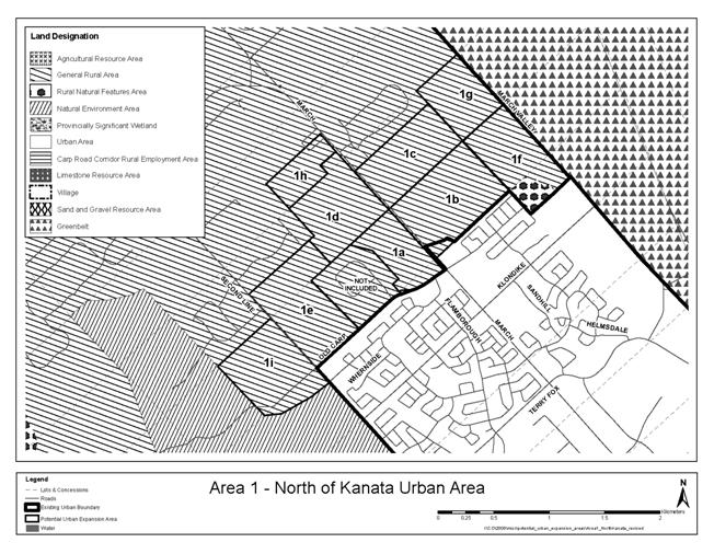
Recommended Urban Expansion Areas
1.
The following areas were
eliminated from the analysis of candidate areas because there was no
residential development potential:
|
Area
|
Gross Ha
|
|
|
1f
|
42.8
|
Proximity
to explosives range
|
|
1g
|
30.0
|
Proximity
to explosives range
|
|
7a
|
20.4
|
Active
pit
|
|
11f
|
39.6
|
Servicing
difficulties and small developable area
|
|
Area
|
Gross Developable
Ha
|
Cumulative
Developable Ha
|
Point Score
|
|
5 (now urban)
|
163.0
|
163.0
|
n/a
|
|
10a
|
78.7
|
241.7
|
66
|
|
6a
|
35.0
|
276.7
|
64
|
|
11a
|
45.7
|
322.4
|
64
|
|
10d
|
8.3
|
330.7
|
62
|
|
11c
|
9.9
|
340.6
|
62
|
|
11e
|
16.9
|
357.5
|
61
|
|
7b
|
35.6
|
393.2
|
58
|
|
7d
|
27.1
|
420.3
|
58
|
|
10e
|
19.9
|
440.1
|
58
|
|
11d
|
39.3
|
479.5
|
56
|
|
6b
|
12.3
|
491.8
|
55
|
|
7c
|
39.5
|
531.3
|
55
|
|
11b
|
33.2
|
564.5
|
55
|
|
9a
|
37.1
|
601.6
|
53
|
|
1b
|
53.9
|
655.5
|
52
|
|
1h
|
15.6
|
671.1
|
52
|
|
10b
|
79.8
|
750.9
|
52
|
|
11h
|
11.8
|
762.6
|
52
|
|
1a
|
25.9
|
832.0
|
51
|
|
1d
|
43.5
|
806.1
|
51
|
|
6c
|
19.8
|
851.9
|
51
|
It is recommended that the following parcels not be supported
for inclusion in the urban area.
|
Area
|
Gross Developable
Ha
|
Cumulative
Developable Ha
|
Point Score
|
|
3
|
69.5
|
921.3
|
49
|
|
10c
|
54.6
|
975.9
|
49
|
|
2
|
47.2
|
1023.2
|
48
|
|
9b
|
29.0
|
1052.1
|
48
|
|
11g
|
43.5
|
1095.6
|
47
|
|
1c
|
39.5
|
1135.1
|
46
|
|
8a
|
21.1
|
1156.2
|
46
|
|
9c.1
|
17.7
|
1173.9
|
46
|
|
1e
|
37.7
|
1211.6
|
45
|
|
9d
|
13.7
|
1225.3
|
44
|
|
4
|
38.5
|
1263.8
|
42
|
|
8b
|
16.5
|
1280.3
|
41
|
|
1i
|
19.1
|
1299.4
|
39
|
|
9c.2
|
5.2
|
1304.6
|
37
|
|
8d
|
30.7
|
1335.3
|
34
|
|
8c
|
17.6
|
1352.9
|
33
|
|
8e
|
41.2
|
1394.1
|
30
|
|
8f
|
43.1
|
1437.2
|
27
|
|
Area
|
Supply of vacant
residential land, 2009 (gross ha)
|
Proposed additional
gross residential ha
|
% increase in gross
land
|
Approximate years
supply with additions (from 2009)
|
|
Kanata-Stittsville
|
1,489.6
|
206.0
|
14%
|
20.0
|
|
Barrhaven
|
808.8
|
102.3
|
13%
|
13.1
|
|
Riverside South
|
1,020.8
|
0.0
|
0%
|
57.6
|
|
Leitrim
|
256.4
|
37.1
|
14%
|
26.3
|
|
Orléans
|
822.8
|
343.5
|
42%
|
20.2
|
|
Total
|
4,398.4
|
688.9*
|
16%
|
21.4
|
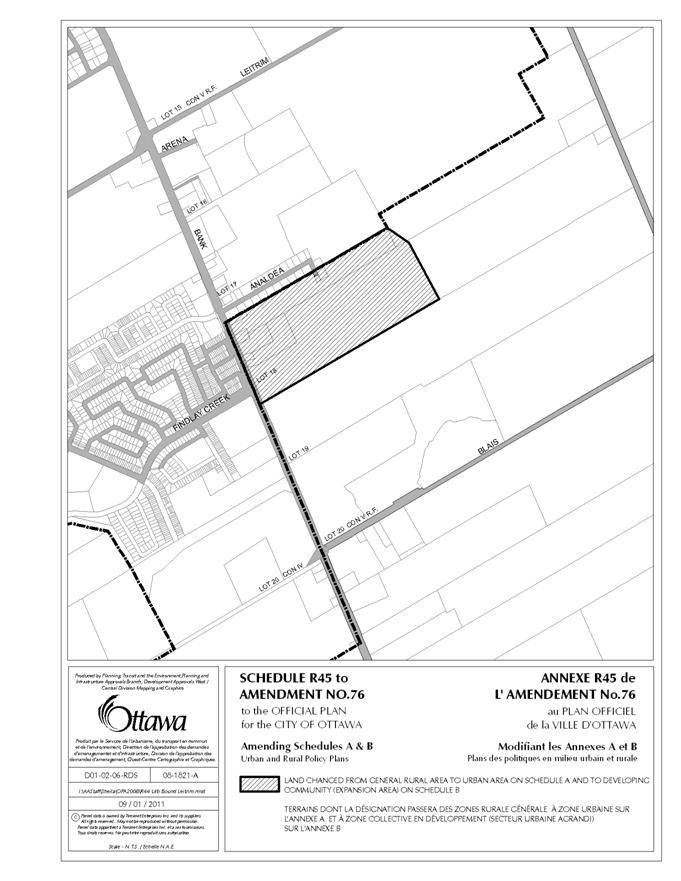
Candidate Area for urban boundary rationalization
Area 2 – West of Terry Fox Extension
|
Location:
West of Terry Fox Drive
north
|
OP Designation:
General Rural Area
|
Current Land Use(s):
Undeveloped scrub land
|
|
Size:
Gross ha = 75
Gross developable ha = 47
|
Zoning:
RU – Rural Countryside
|
|
Planning Status:
Richcraft Group of
Companies submitted an Official Plan Amendment application in 2007 that
included these lands. It was deemed incomplete.
|
Adjacent Land Use
designations:
South and West:
Agricultural Resource Area
East: Urban Area
North: Natural Environment
Area
|
Adjacent Land Use(s): Huntmar Drive and agriculture to the west, Carp
River to the south, future Terry Fox alignment to the east, and South March
Highlands to the north.
|
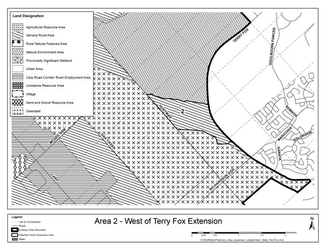
Evaluation – Area 2
|
Parcel ID
|
Gross ha
|
NHS feature
|
NHS areas removed
|
Limestone Resource
500m setback
|
Landfill 500m
setback
|
Other constraints
|
Notes re other
constraints
|
Gross ha
developable
|
|
2
|
75.2
|
Escarpment
|
1.0
|
0.0
|
0.0
|
27.0
|
Carp River
floodplain
|
47.2
|
Additional Comments:
|
Criteria
|
Area 2 - Infrastructure
|
|
1. Water
|
The water supply (existing and proposed) to Area 2
in Pressure Zone 3W is very good and no specific upgrades to any existing or
proposed piping or pumping would be required.
|
|
2. Wastewater
|
The area can be serviced by
routing the flow towards the Signature Ridge Pump Station (SRPS). An upgrade
of the SRPS is required in order to service existing build-out conditions and
could incorporate a further capacity increase to service the subject area.
Approximately 1600 m of trunk sewer will be required along Terry Fox Drive.
This sewer will also service the adjacent development on the interstitial
lands within the urban boundary. Given the elevation of the subject lands, a
separate PS may be required due to overflow elevation constraints stemming
from the SRPS. If the serviced area is limited to higher elevations the property
can be serviced by a gravity sewer.
|
|
3. Stormwater
|
There would be a need to
update the impact assessment for the Carp River.
|
Transportation
The Transportation Master
Plan seeks to provide a sufficient peak hour directional capacity to achieve a
Level of Service “D” for screenlines outside of the City’s inner core. Based
on this standard there would be sufficient planned future road capacity at the
Campeau Road screenline (#53) to accommodate this growth but the Eagleson Road
screenline (#10) at the Greenbelt does not have capacity for this Level of
Service.
|
|
Criteria
¯
|
Area
2
|
|
Water
|
1
|
8
|
|
Wastewater
|
2
|
6
|
|
Stormwater
|
3
|
4
|
|
Road
Capacity
|
4
|
0
|
|
Arterial
& Collector Road Frontage
|
5
|
Terry Fox
|
|
5
|
Huntmar
|
|
Arterial-Collector
Frontage Score
|
5
|
6
|
|
Distance
to Rapid Transit
|
6
|
3.9
|
|
Transit
Score
|
6
|
2
|
|
Distance
to Mainstreet or MUC
|
7
|
3.4
|
|
Mainstreet
Score
|
7
|
4
|
|
Jobs-Housing
Balance
|
8
|
1.40
|
|
Jobs-Housing
Balance Score
|
8
|
3
|
|
Distance
to Major Recreational Facility
|
9
|
3.5
|
|
Major
Rec Facility Score
|
9
|
3
|
|
Emergency
Services POLICE
|
10
|
4.5
|
|
Emergency
Services FIRE
|
10
|
6.1
|
|
Emergency
Services AMBULANCE
|
10
|
5.0
|
|
Emergency
Services AVERAGE
|
10
|
5.2
|
|
Emergency
Score
|
10
|
2
|
|
Connectivity
|
11
|
0
|
|
Local
Bus
|
12
|
0
|
|
Agricultural
land adjacent
|
13
|
117
|
|
Agricultural
land adjacent Score
|
13
|
0
|
|
Country
Lot or Landfill adjacent
|
14
|
none
|
|
Country
Lot or Landfill adjacent Score
|
14
|
4
|
|
Depth
to Bedrock
|
15
|
over 5
|
|
Depth
to Bedrock Score
|
15
|
2
|
|
Urban
Land Supply Score
|
16
|
4
|
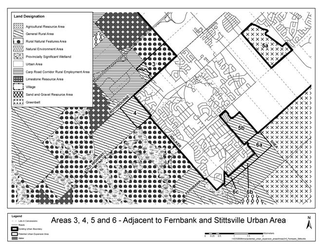
Candidate Area for urban boundary rationalization
Area 3 – North of Stittsville
|
Location:
North of Stittsville urban
boundary, west of Kanata West urban boundary, south of Hwy 417 and three lots
east of Carp Road
|
OP Designation:
Rural Natural Feature
|
Current Land Use(s):
Vacant
|
|
Size:
Gross ha = 70
Gross developable ha = 70
|
Zoning:
RU – Rural Countryside
|
|
Planning Status:
No active application;
Subject of an appeal on the
2003 Official Plan urban boundary
|
Adjacent Land Use
designations:
South and East: Urban Area
West: Carp Road Corridor
Rural Employment Area
North: Rural Natural
Feature
|
Adjacent Land Use(s):
Vacant to north;
Residential in south;
Planned employment in east;
Rural residential along
Lloydalex and Carp Road in west.
|

Evaluation – Area 3
|
Parcel ID
|
Gross ha
|
NHS feature
|
NHS areas removed
|
Limestone Resource
500m setback
|
Landfill 500m
setback
|
Other constraints
|
Notes re other
constraints
|
Gross ha
developable
|
|
3
|
69.5
|
|
|
0.0
|
0.0
|
0.0
|
|
69.5
|
Additional Comments:
The property is designated Rural Natural Feature in the OP
but the owner has recently cut down all the trees.
|
Criteria
|
Area 3 - Infrastructure
|
|
1. Water
|
The water supply (existing and proposed) to Area 3
in Pressure Zone 3W is very good and no specific upgrades to any existing or
proposed piping or pumping would be required. The proposed 762 mm diameter
Hazeldean watermain feeding this area would only need to be up-sized if all
Areas 3, 4, 6b and 6c were to be serviced and the Stittsville Elevated Water
Tank is relocated in the future.
|
|
2. Wastewater
|
Area 3 lies immediately
west of the Kanata West Development Area, and hence can be serviced by the
proposed Kanata West Pumping Station. The proposed trunk sewer on Maple Grove
can be upsized and extended to the parcel.
|
|
3. Stormwater
|
Drains to Feedmill Creek
(within Carp River watershed). Existing studies would require updating; some
areas of shallow overburden (blasting may be required to service).
|
Transportation
The Transportation Master
Plan seeks to provide a sufficient peak hour directional capacity to achieve a
Level of Service “D” for screenlines outside of the City’s inner core. Based
on this standard the future road capacity across the Terry Fox screenline (#44)
can accommodate this growth, however the Eagleson Road screenline (#10) at the
Greenbelt does not have capacity for this Level of Service.
|
|
Criteria
¯
|
Area 3
|
|
Water
|
1
|
8
|
|
Wastewater
|
2
|
8
|
|
Stormwater
|
3
|
4
|
|
Road
Capacity
|
4
|
0
|
|
Arterial
& Collector Road Frontage
|
5
|
Carp
|
|
5
|
-
|
|
Arterial-Collector
Frontage Score
|
5
|
4
|
|
Distance
to Rapid Transit
|
6
|
3.0
|
|
Transit
Score
|
6
|
4
|
|
Distance
to Mainstreet or MUC
|
7
|
2.3
|
|
Mainstreet
Score
|
7
|
5
|
|
Jobs-Housing
Balance
|
8
|
1.39
|
|
Jobs-Housing
Balance Score
|
8
|
3
|
|
Distance
to Major Recreational Facility
|
9
|
5.4
|
|
Major
Rec Facility Score
|
9
|
1
|
|
Emergency
Services POLICE
|
10
|
3.1
|
|
Emergency
Services FIRE
|
10
|
3.3
|
|
Emergency
Services AMBULANCE
|
10
|
3.6
|
|
Emergency
Services AVERAGE
|
10
|
3.3
|
|
Emergency
Score
|
10
|
4
|
|
Connectivity
|
11
|
0
|
|
Local
Bus
|
12
|
1
|
|
Agricultural
land adjacent
|
13
|
0
|
|
Agricultural
land adjacent Score
|
13
|
2
|
|
Country
Lot or Landfill adjacent
|
14
|
Lloydalex
|
|
Country
Lot or Landfill adjacent Score
|
14
|
0
|
|
Depth
to Bedrock
|
15
|
2-5
|
|
Depth
to Bedrock Score
|
15
|
1
|
|
Urban
Land Supply Score
|
16
|
4
|
Candidate Area for urban boundary
rationalization
Area 4 – West of Stittsville
|
Location:
West of Stittsville, north
of Hazeldean Road
|
OP Designation:
General Rural Area
|
Current Land Use(s):
Fields, forest, one
residential use
|
|
Size:
Gross ha = 59
Gross developable ha = 39
|
Zoning:
RU – Rural Countryside
|
|
Planning Status:
No application
|
Adjacent Land Use
designations:
North: Carp Road Corridor
Rural Employment Area
West: General Rural Area
South: Rural Natural
Feature East: Urban Area
|
Adjacent Land Use(s):
Urban residential to the
east, forested to the south, forest and farm to west, rural industrial to the
north and quarry to the northwest.
|
Evaluation – Area 4
|
Parcel ID
|
Gross ha
|
NHS
feature
|
NHS areas removed
|
Limestone Resource
500m setback
|
Landfill 500m
setback
|
Other constraints
|
Notes re other
constraints
|
Gross ha
developable
|
|
4
|
59.0
|
Woodland-Wetland
|
17.0
|
1.2
|
0.0
|
2.3
|
Hydro ROW
|
38.5
|
Criteria
|
Area 4 -
Infrastructure
|
|
1. Water
|
The water supply (existing
and proposed) to Area 4 (future Stittsville Pressure Zone) would require a
minor expansion of the future Stittsville PS. Piping upgrades on Hazeldean
Road (west of Carp Road) and through the development east of Area 4 would
also be required. The proposed 762 mm diameter Hazeldean watermain feeding
this area would only need to be up-sized if all Areas 3, 4, 6b and 6c were to
be serviced and the Stittsville Elevated Water Tank is relocated in the
future.
|
|
2. Wastewater
|
Area 4 is located east of
Stittsville. Following the extension of the trunk sewer to service Area 3, an
additional 1200 m of trunk sewer along Rothbourne/Maple Grove Road will be
required. This additional flow will also need to be accounted for in the
upgrades along Maple Grove and at the Kanata West Pumping Station
|
|
3. Stormwater
|
Drains to Feedmill Creek
(within Carp River watershed). Drainage of Area 4 may be challenging because
of constraints created by the existing Timbermere subdivision to the east.
Existing studies would require updating; some areas of shallow overburden
(blasting may be required to service).
|
Transportation
The Transportation Master
Plan seeks to provide a sufficient peak hour directional capacity to achieve a
Level of Service “D” for screenlines outside of the City’s inner core. With
the coming into effect of OPA 77, lands added in Area 5 will use all capacity
that been assigned to Area 4 in the 2009 analysis. Based on the Level of
Service “D” standard the future road capacity across the Terry Fox screenline
(#44) can accommodate this growth, however the Eagleson Road screenline (#10)
at the Greenbelt does not have capacity for this Level of Service.
|
|
Criteria
¯
|
Area 4
|
|
Water
|
1
|
4
|
|
Wastewater
|
2
|
4
|
|
Stormwater
|
3
|
4
|
|
Road
Capacity
|
4
|
0
|
|
Arterial
& Collector Road Frontage
|
5
|
Hazeldean
|
|
5
|
Rothbourne
|
|
Arterial-Collector
Frontage Score
|
5
|
6
|
|
Distance
to Rapid Transit
|
6
|
4.9
|
|
Transit
Score
|
6
|
0
|
|
Distance
to Mainstreet or MUC
|
7
|
2.0
|
|
Mainstreet
Score
|
7
|
5
|
|
Jobs-Housing
Balance
|
8
|
1.40
|
|
Jobs-Housing
Balance Score
|
8
|
3
|
|
Distance
to Major Recreational Facility
|
9
|
4.5
|
|
Major
Rec Facility Score
|
9
|
2
|
|
Emergency
Services POLICE
|
10
|
4.9
|
|
Emergency
Services FIRE
|
10
|
4.2
|
|
Emergency
Services AMBULANCE
|
10
|
3.2
|
|
Emergency
Services AVERAGE
|
10
|
4.1
|
|
Emergency
Score
|
10
|
3
|
|
Connectivity
|
11
|
0
|
|
Local
Bus
|
12
|
0
|
|
Agricultural
land adjacent
|
13
|
0
|
|
Agricultural
land adjacent Score
|
13
|
2
|
|
Country
Lot or Landfill adjacent
|
14
|
none
|
|
Country
Lot or Landfill adjacent Score
|
14
|
4
|
|
Depth
to Bedrock
|
15
|
2-5
|
|
Depth
to Bedrock Score
|
15
|
1
|
|
Urban
Land Supply Score
|
16
|
4
|
Area 5: The two parcels evaluated in 2009 were designated
Urban Area by Official Plan Amendment 77 (Fernbank CDP) and no longer require
evaluation.
Candidate Area for urban boundary
rationalization
Area 6 – South of Stittsville
|
Location:
South of Stittsville and
Fernbank Urban Area
|
OP Designation:
General Rural Area
|
Current Land Use(s):
6c is cleared for
development and the rest is scrub and old fields.
|
|
Size:
Gross ha = 73
Gross developable ha = 67
|
Zoning:
RU – Rural Countryside
RR2
– Rural Residential
|
|
Planning Status:
Ray Bell has an active
application for an urban expansion on parcel 6c.
|
Adjacent Land Use
designations:
North: Urban Area
East: Agricultural
Resource Area
South: General Rural Area
West: General Rural Area
|
Adjacent Land Use(s):
South of 6c is a Country
Lot Subdivision, scrub and forest are south of 6a and b, Stittsville
residential is to the north and agriculture is to the east.
|
Evaluation – Area 6
|
Parcel ID
|
Gross ha
|
NHS feature
|
NHS areas removed
|
Limestone Resource
500m setback
|
Landfill 500m
setback
|
Other constraints
|
Notes re other
constraints
|
Gross ha
developable
|
|
6a
|
41.0
|
|
|
|
|
6.0
|
Hydro ROW
|
35.0
|
|
6b
|
12.3
|
|
|
|
|
|
|
12.3
|
|
6c
|
19.8
|
|
|
|
|
|
|
19.8
|
|
Sub-total
|
73.1
|
|
0.0
|
0.0
|
0.0
|
6.0
|
|
67.1
|
|
Criteria
|
Area 6 - Infrastructure
|
|
1. Water
|
The water supply to Area 6a
(Pressure Zone 3W) could easily be included as part of the Fernbank CDP and
servicing could be easily integrated into this future development at a very
small cost. The water supply (existing and proposed) to Areas 6b and 6c
(future Stittsville Pressure Zone) would require a minor upgrade to the
future Stittsville PS and the installation of a check valve connection to
the future water distribution system in Fernbank. The proposed 762 mm
diameter Hazeldean watermain feeding this area would only need to be up-sized
if all Areas 3, 4, 6b and 6c were to be serviced and the Stittsville Elevated
Water Tank is relocated in the future.
|
|
2. Wastewater
|
Area 6a, 6b, and 6c
generally slope in an easterly direction, and would fall within the area
serviced by Hazeldean Pump Station. Relatively high ground elevations present
an opportunity to service these lands through the Fernbank community. Further
upsizing of the Fernbank Trunks and upgrade to the Hazeldean PS will be
required. Alternatively, a portion of the areas may be serviced by the
Stittsville PS. In addition to the same downstream upgrades, an upgrade to
the Stittsville PS will be required.
|
|
3. Stormwater
|
The Area 6 alternative
sites fall within the Jock River Reach 2 subwatershed. The existing
subwatershed study and/or Fernbank EMP would require updating/expansion for
southerly parcels. All alternatives sites have little or no drainage
constraints. Drainage / stormwater management of the alternative sites is
reasonably straightforward using conventional engineering methods.
|
Transportation
The
Transportation Master Plan seeks to provide a sufficient peak hour directional
capacity to achieve a Level of Service “D” for screenlines outside of the
City’s inner core. Based on this standard the future road capacity
across the Terry Fox screenline (#44) can accommodate this growth, however the
Eagleson Road screenline (#10) at the Greenbelt does not have capacity for this
Level of Service.
|
|
Criteria
¯
|
Area 6a
|
Area 6b
|
Area 6c
|
|
Water
|
1
|
8
|
6
|
6
|
|
Wastewater
|
2
|
6
|
6
|
6
|
|
Stormwater
|
3
|
4
|
4
|
4
|
|
Road
Capacity
|
4
|
0
|
0
|
0
|
|
Arterial
& Collector Road Frontage
|
5
|
Fernbank
|
none
|
Stittsville Main
|
|
5
|
Shea
|
Hartsmere
|
Hartsmere
|
|
Arterial-Collector
Frontage Score
|
5
|
6
|
2
|
6
|
|
Distance
to Rapid Transit
|
6
|
2.0
|
2.8
|
3.3
|
|
Transit
Score
|
6
|
8
|
6
|
4
|
|
Distance
to Mainstreet or MUC
|
7
|
2.0
|
1.9
|
1.6
|
|
Mainstreet
Score
|
7
|
5
|
5
|
5
|
|
Jobs-Housing
Balance
|
8
|
1.40
|
1.40
|
1.39
|
|
Jobs-Housing
Balance Score
|
8
|
3
|
3
|
3
|
|
Distance
to Major Recreational Facility
|
9
|
1.8
|
2.4
|
3.2
|
|
Major
Rec Facility Score
|
9
|
5
|
4
|
3
|
|
Emergency
Services POLICE
|
10
|
6.3
|
7.0
|
8.0
|
|
Emergency
Services FIRE
|
10
|
2.3
|
2.1
|
1.6
|
|
Emergency
Services AMBULANCE
|
10
|
1.9
|
1.9
|
1.6
|
|
Emergency
Services AVERAGE
|
10
|
3.5
|
3.7
|
3.7
|
|
Emergency
Score
|
10
|
4
|
4
|
4
|
|
Connectivity
|
11
|
4
|
4
|
3
|
|
Local
Bus
|
12
|
2
|
0
|
1
|
|
Agricultural
land adjacent
|
13
|
49
|
0
|
0
|
|
Agricultural
land adjacent Score
|
13
|
0
|
2
|
2
|
|
Country
Lot or Landfill adjacent
|
14
|
none
|
none
|
Forestgrove &
Brads
|
|
Country
Lot or Landfill adjacent Score
|
14
|
4
|
4
|
0
|
|
Depth
to Bedrock
|
15
|
2-5
|
2-5
|
0-2
|
|
Depth
to Bedrock Score
|
15
|
1
|
1
|
0
|
|
Urban
Land Supply Score
|
16
|
4
|
4
|
4
|
Candidate Area for urban boundary
rationalization
Area 7 – South of Barrhaven east of
Highway 416
|
Location:
East of Hwy 416 south of
the urban boundary
|
OP Designation:
Sand and Gravel Resource
Area
|
Current Land Use(s):
Mineral extraction and
agriculture
|
|
Size:
Gross ha = 123
Gross developable ha = 102
|
Zoning:
MR – Mineral Aggregate
Reserve
ME – Mineral Extraction
|
|
Planning Status:
Official Plan Amendment
Application submitted by Minto Communities for a larger area
|
Adjacent Land Use
designations:
North and East: Urban Area
South: Agricultural
Resource Area
West: General Rural Area
|
Adjacent Land Use(s):
Currently under development
to the north, agriculture and urban development to the east, agriculture to
the south, and mineral extraction and landfill to the west.
|
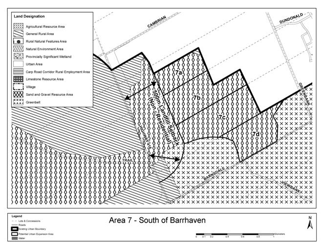
Evaluation – Area 7
|
Parcel ID
|
Gross ha
|
NHS feature
|
NHS areas removed
|
Limestone Resource
500m setback
|
Landfill 500m
setback
|
Other constraints
|
Notes re other
constraints
|
Gross ha
developable
|
|
7a
|
20.4
|
|
|
|
|
20.4
|
active pit
|
27.2
|
|
7b
|
35.6
|
|
|
|
|
|
|
35.6
|
|
7c
|
39.5
|
|
|
|
|
|
|
39.5
|
|
7d
|
27.1
|
|
|
|
|
|
|
27.1
|
|
Sub-total
|
122.7
|
|
0.0
|
0.0
|
0.0
|
20.4
|
|
102.3
|
Additional
Comments:
A requirement exists for a
“notice on title” advising of odours for residential properties within one
kilometre of the Trail Road landfill property boundary. Residential uses are
not permitted within 500 metres of the landfill.
|
Criteria
|
Area 7 - Infrastructure
|
|
1. Water
|
The
water supply piping (existing and proposed) to Area 7 is very good and no
specific upgrades to any existing or proposed piping would be required.
However, the City is currently planning a major reconfiguration of Pressure
Zones BARR and 2W with a new future Pressure Zone 3C which would impact the
pressures available to Area 7. A new booster pumping station would likely be
required to service the majority of Areas 7a, 7b and 7c (with minimal or no
piping upgrades required) that are at elevation of 106 metres or higher The
cost per unit would be reduced by only servicing the lower lying areas or
maximizing the number units serviced by a new pumping station.
|
|
2. Wastewater
|
The total area can be
serviced through the South Nepean Collector (SNC). The area may be serviced
by gravity by upsizing the proposed trunks along Greenbank Road and Cambrian
Road. Any low lying area (potentially within Area 7a) may be serviced by
upsizing the Barrhaven South trunk sewer along the Jock River. According to
the Barrhaven South Master Servicing Study (June 2007), a proposed trunk
sewer (900 mm) from Greenbank to SNC has a residual capacity that would allow
for the servicing of all 2781 units or 8033 people (the trunk has been
recently installed). The next bottleneck in the system is West Rideau Collector
(WRC) downstream of Hunt Club Road with residual capacity that would limit
development to 1750 units (5000 people). This constraint can be alleviated to
service entire area by simply diverting flow from the Barrhaven Community to
the Greenbank Trunk at a relatively low cost.
|
|
3. Stormwater
|
Area
is in the Jock River watershed. The subwatershed plan and/or the Barrhaven
South Master Servicing Plan would need updating. The incremental impact of
Area 7a on drainage constraints in Barrhaven South may be manageable,
however, the cumulative impact of drainage from Areas 7a, 7b, and 7c would be
challenging given the constraints in storm drainage systems planned and built
in Barrhaven South.
|
Transportation
The
Transportation Master Plan seeks to provide a sufficient peak hour directional
capacity to achieve a Level of Service “D” for screenlines outside of the
City’s inner core. Based on this standard the future road capacity
across the Jock River screenline (#49) and Fallowfield screenline (#9) can accommodate
this growth.
|
|
Criteria
¯
|
Area 7a
|
Area 7b
|
Area 7c
|
Area 7 d
|
|
Water
|
1
|
2
|
2
|
2
|
2
|
|
Wastewater
|
2
|
8
|
8
|
8
|
8
|
|
Stormwater
|
3
|
4
|
0
|
0
|
0
|
|
Road
Capacity
|
4
|
3
|
3
|
3
|
3
|
|
Arterial
& Collector Road Frontage
|
5
|
Greenbank extension
|
Greenbank extension
|
Greenbank extension
|
Greenbank extension
|
|
5
|
Cedarview
|
Cedarview
|
Cedarview
|
Barnsdale &
Cedarview
|
|
Arterial-Collector
Frontage Score
|
5
|
6
|
6
|
6
|
6
|
|
Distance
to Rapid Transit
|
6
|
0.3
|
0.3
|
0.3
|
0.3
|
|
Transit
Score
|
6
|
10
|
10
|
10
|
10
|
|
Distance
to Mainstreet or MUC
|
7
|
2.8
|
3.6
|
3.8
|
4.1
|
|
Mainstreet
Score
|
7
|
4
|
4
|
3
|
3
|
|
Jobs-Housing
Balance
|
8
|
1.24
|
1.22
|
1.20
|
1.19
|
|
Jobs-Housing
Balance Score
|
8
|
2
|
2
|
2
|
1
|
|
Distance
to Major Recreational Facility
|
9
|
2.0
|
2.1
|
2.4
|
2.4
|
|
Major
Rec Facility Score
|
9
|
5
|
4
|
4
|
4
|
|
Emergency
Services POLICE
|
10
|
6.7
|
6.0
|
5.5
|
4.7
|
|
Emergency
Services FIRE
|
10
|
2.0
|
2.1
|
2.3
|
2.5
|
|
Emergency
Services AMBULANCE
|
10
|
4.5
|
5.1
|
5.3
|
5.5
|
|
Emergency
Services AVERAGE
|
10
|
4.4
|
4.4
|
4.4
|
4.2
|
|
Emergency
Score
|
10
|
3
|
3
|
3
|
3
|
|
Connectivity
|
11
|
4
|
4
|
4
|
4
|
|
Local
Bus
|
12
|
0
|
0
|
0
|
0
|
|
Agricultural
land adjacent
|
13
|
0
|
0
|
40
|
122
|
|
Agricultural
land adjacent Score
|
13
|
2
|
2
|
0
|
0
|
|
Country
Lot or Landfill adjacent
|
14
|
Trail Road Landfill
|
Trail Road Landfill
|
Trail Road Landfill
|
none
|
|
Country
Lot or Landfill adjacent Score
|
14
|
0
|
0
|
0
|
4
|
|
Depth
to Bedrock
|
15
|
over 5
|
over 5
|
over 5
|
over 5
|
|
Depth
to Bedrock Score
|
15
|
2
|
2
|
2
|
2
|
|
Urban
Land Supply Score
|
16
|
8
|
8
|
8
|
8
|
Candidate Area for
urban boundary rationalization
Area 8 – South of Leitrim
|
Location:
South of Leitrim Urban Area
|
OP Designation:
General Rural Area
|
Current Land Use(s):
Scrub
Racetrack
|
|
Size:
Gross ha = 262
Gross developable ha = 170
|
Zoning:
RU – Rural Countryside
RC4 – Rural Commercial (racetrack)
ME – Mineral Extraction
|
|
Planning Status:
OPA application from
Richcraft Group of Companies includes part of Area 8c.
|
Adjacent Land Use
designations:
South: Sand and Gravel
Resource Area
North: Urban Area
East: Limestone Resource
Area and General Rural Area
West: Sand and Gravel
Resource Area
|
Adjacent Land Use(s):
South: sand and gravel
pits
North: under development
(residential)
East: Quarry
West: Idle, golf course,
potential future location of CCE.
|
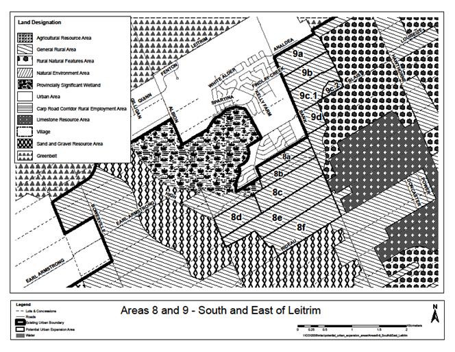
Evaluation – Area 8
|
Parcel ID
|
Gross ha
|
NHS feature
|
NHS areas removed
|
Limestone Resource
500m setback
|
Landfill 500m
setback
|
Other constraints
|
Notes re other
constraints
|
Gross ha
developable
|
|
8a
|
22.5
|
|
|
1.4
|
|
|
|
21.1
|
|
8b
|
22.6
|
Wetland
|
1.0
|
5.1
|
|
|
|
16.5
|
|
8c
|
48.2
|
Woodland-Wetland
|
17.0
|
13.6
|
|
|
|
17.6
|
|
8d
|
33.7
|
Wetland
|
3.0
|
0.0
|
|
|
|
30.7
|
|
8e
|
74.3
|
Woodland
|
26.0
|
7.1
|
|
|
|
41.2
|
|
8f
|
61.1
|
Woodland
|
3.0
|
15.0
|
|
|
|
43.1
|
|
Sub-total
|
262.4
|
|
50.0
|
42.2
|
0.0
|
0.0
|
|
170.2
|
Additional Comments:
The Rural Road Network Schedule shows a Conceptual
Arterial (alignment undefined) road between Albion Road and Bank Street south
of the Leitrim urban boundary.
|
Criteria
|
Area 8 - Infrastructure
|
|
1. Water
|
Collectively Area 8 and
Area 9 could add a potential 1,620 units to Leitrim and would necessitate
pumping and piping upgrades. However, as individual parcels they do not
represent a significant increase in water demand, but the topography of these
parcels precludes inclusion of a portion of 8a and all remaining areas in the
3C pressure zone. The Leitrim pump station would have to be upgraded and some
additional watermains installed to provide appropriate pressures.
|
|
2. Wastewater
|
The Conroy Road Trunk is constrained and provides no
residual capacity beyond current build-out conditions. The replacement of
approximately 1500 m of the Conroy Trunk would provide residual capacity for
up to 1200 units (3500 people). Servicing
of the entire area would require the higher cost upgrade/replacement of
Leitrim PS, additional segments of the Conroy Road Collector, and the Green
Creek Collector. An alternative to the Green Creek Collector upgrades would
be to install a bypass pipe connecting the Conroy Road Collector to the South
Ottawa Collector. A trunk sewer from Area 8 leading to the Leitrim PS will
also be required.
|
|
3. Stormwater
|
All the parcels are in
Findlay Creek watershed. No subwatershed plan available to guide development.
All alternative sites have little or no drainage constraints.
Drainage/stormwater management of the alternative sites is reasonably
straightforward using conventional engineering methods.
|
Transportation
The Transportation Master
Plan seeks to provide sufficient peak hour directional capacity to achieve a
Level of Service “D” for screenlines outside of the City’s inner core. Based
on this standard future road capacity is available at the Rideau River
screenline (#42) but the Leitrim Road screenline (#8) does not have capacity
for this Level of Service.
|
|
Criteria
¯
|
Area 8a
|
Area 8b
|
Area 8c
|
Area 8d
|
Area 8e
|
Area 8f
|
|
Water
|
1
|
4
|
2
|
0
|
0
|
0
|
0
|
|
Wastewater
|
2
|
8
|
6
|
4
|
2
|
2
|
2
|
|
Stormwater
|
3
|
8
|
8
|
6
|
6
|
6
|
6
|
|
Road
Capacity
|
4
|
0
|
0
|
0
|
0
|
0
|
0
|
|
Arterial
& Collector Road Frontage
|
5
|
Bank
|
Albion &
Armstrong
|
Bank
|
Albion &
Armstrong
|
Albion & Bank
|
Bank
|
|
5
|
future collector to
north
|
-
|
-
|
-
|
-
|
Rideau Rd
|
|
Arterial-Collector
Frontage Score
|
5
|
6
|
8
|
4
|
8
|
8
|
6
|
|
Distance
to Rapid Transit
|
6
|
4.7
|
4.5
|
4.2
|
3.5
|
4.4
|
4.8
|
|
Transit
Score
|
6
|
0
|
0
|
0
|
4
|
0
|
0
|
|
Distance
to Mainstreet or MUC
|
7
|
6.0
|
6.3
|
6.6
|
7.6
|
7.2
|
7.9
|
|
Mainstreet
Score
|
7
|
2
|
1
|
1
|
0
|
1
|
0
|
|
Jobs-Housing
Balance
|
8
|
1.25
|
1.20
|
1.15
|
1.07
|
0.98
|
0.90
|
|
Jobs-Housing
Balance Score
|
8
|
3
|
2
|
1
|
0
|
0
|
0
|
|
Distance
to Major Recreational Facility
|
9
|
4.3
|
4.6
|
5.0
|
5.4
|
5.6
|
6.0
|
|
Major
Rec Facility Score
|
9
|
2
|
2
|
2
|
1
|
1
|
1
|
|
Emergency
Services POLICE
|
10
|
3.1
|
3.4
|
3.7
|
4.7
|
4.2
|
5.0
|
|
Emergency
Services FIRE
|
10
|
3.3
|
3.5
|
3.9
|
4.8
|
4.4
|
5.1
|
|
Emergency
Services AMBULANCE
|
10
|
9.9
|
10.2
|
10.5
|
11.4
|
11.0
|
11.7
|
|
Emergency
Services AVERAGE
|
10
|
5.4
|
5.7
|
6.0
|
7.0
|
6.5
|
7.3
|
|
Emergency
Score
|
10
|
2
|
2
|
2
|
1
|
1
|
1
|
|
Connectivity
|
11
|
4
|
3
|
4
|
4
|
4
|
4
|
|
Local
Bus
|
12
|
0
|
0
|
0
|
0
|
0
|
0
|
|
Agricultural
land adjacent
|
13
|
0
|
0
|
0
|
0
|
0
|
0
|
|
Agricultural
land adjacent Score
|
13
|
2
|
2
|
2
|
2
|
2
|
2
|
|
Country
Lot or Landfill adjacent
|
14
|
none
|
none
|
none
|
none
|
none
|
none
|
|
Country
Lot or Landfill adjacent Score
|
14
|
4
|
4
|
4
|
4
|
4
|
4
|
|
Depth
to Bedrock
|
15
|
2-5
|
2-5
|
2-5
|
over 5
|
2-5
|
2-5
|
|
Depth
to Bedrock Score
|
15
|
1
|
1
|
1
|
2
|
1
|
1
|
|
Urban
Land Supply Score
|
16
|
0
|
0
|
0
|
0
|
0
|
0
|
Candidate Area for urban boundary
rationalization
Area 9 – East of Leitrim
|
Location:
East and south of Leitrim,
east of Bank Street.
|
OP Designation:
General Rural Area
|
Current Land Use(s):
Scrub and scattered
commercial uses
|
|
Size:
Gross ha = 124
Gross developable ha = 103
|
Zoning:
RU – Rural Countryside
|
|
Planning Status:
No active applications
|
Adjacent Land Use
designations:
North: Urban Area
South and East: Rural Natural Feature
West: Urban Area
|
Adjacent Land Use(s):
Urban residential
development to the north and west. Forest to the east. Quarries to the
south.
|
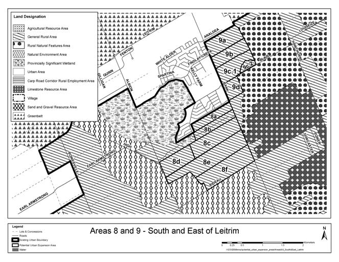
Evaluation – Area 9
|
Parcel ID
|
Gross ha
|
NHS feature
|
NHS areas removed
|
Limestone Resource
500m setback
|
Landfill 500m
setback
|
Other constraints
|
Notes re other
constraints
|
Gross ha
developable
|
|
9a
|
37.1
|
|
|
|
|
|
|
37.1
|
|
9b
|
29.0
|
|
|
|
|
|
|
29.0
|
|
9c.1
|
33.7
|
|
|
|
|
16.0
|
Stormwater pond
|
17.7
|
|
9c.2
|
6.7
|
Woodland
|
1.5
|
|
|
|
|
5.2
|
|
9d
|
17.4
|
Woodland
|
3.0
|
0.7
|
|
|
|
13.7
|
|
Sub-total
|
123.9
|
|
4.5
|
0.7
|
0.0
|
0.0
|
|
102.7
|
Additional Comments:
The provision of a sanitary sewer through parcel 9a
eliminates the need for a pumping station within the current urban boundary.
Both parcels 9a and 9b would drain to the stormwater pond in parcel 9c.1.
|
Criteria
|
Area 9 - Infrastructure
|
|
1. Water
|
Recent and planned upgrades
to the water supply system will permit servicing of the individual areas.
However, if they were to be developed collectively, some pipe and pump station
upgrades would be required. Pumping and piping upgrades would be required to
service more than approximately 1,620 units (4,700 additional persons) in
Areas 8 and 9 combined (1,946 units or 5,643 persons are planned for Area 9
alone).
|
|
2. Wastewater
|
The Conroy Road Trunk is
constrained and provides no residual capacity beyond current build-out
conditions. Upgrade to a section of Conroy Road sewer (with no residual
capacity) will accommodate approximately 1200 units (3500 people), beyond
which further upgrades will be required. Areas 9a, 9b, and part of 9c may be
serviced with the upgrade. Servicing of the entire area would require the
higher cost upgrade/ replacement of Leitrim PS, additional segments of the
Conroy Road Collector, and the Green Creek Collector. An alternative to the
Green Creek Collector upgrades would be to install a bypass pipe connecting
the Conroy Road Collector to the South Ottawa Collector.
|
|
3. Stormwater
|
All the parcels are in
Findlay Creek watershed. No subwatershed plan available to guide development,
however the Findlay Creek Stormwater Facility was subject to extensive review
and has a relatively current MOE Certificate of Approval. With the exception
of Area 9d, all alternative sites have little or no drainage constraints.
Drainage / stormwater management of sites 9a, 9b, and 9c is reasonably
straightforward using conventional engineering methods. Area 9d is
constrained by watercourses that cross the land with sizeable external
drainage areas.
|
Transportation
The Transportation Master
Plan seeks to provide a sufficient peak hour directional capacity to achieve a
Level of Service “D” for screenlines outside of the City’s inner core. Based
on this standard the future road capacity is available at the Rideau River
screenline (#42) but the Leitrim Road screenline (#8) does not have capacity
for this Level of Service.
|
|
Criteria
¯
|
Area 9a
|
Area 9b
|
Area 9c.1
|
Area 9c.2
|
Area 9d
|
|
Water
|
1
|
8
|
8
|
8
|
8
|
6
|
|
Wastewater
|
2
|
8
|
8
|
6
|
6
|
6
|
|
Stormwater
|
3
|
8
|
8
|
8
|
8
|
8
|
|
Road
Capacity
|
4
|
0
|
0
|
0
|
0
|
0
|
|
Arterial
& Collector Road Frontage
|
5
|
Bank
|
Bank
|
Bank
|
none
|
Bank
|
|
5
|
-
|
-
|
Blais
|
Blais
|
Blais
|
|
Arterial-Collector
Frontage Score
|
5
|
4
|
4
|
6
|
2
|
6
|
|
Distance
to Rapid Transit
|
6
|
4.8
|
5.1
|
5.1
|
6.0
|
5.7
|
|
Transit
Score
|
6
|
0
|
0
|
0
|
0
|
0
|
|
Distance
to Mainstreet or MUC
|
7
|
4.2
|
4.6
|
4.7
|
5.6
|
5.2
|
|
Mainstreet
Score
|
7
|
3
|
3
|
3
|
2
|
2
|
|
Jobs-Housing
Balance
|
8
|
1.20
|
1.12
|
1.08
|
1.06
|
1.03
|
|
Jobs-Housing
Balance Score
|
8
|
2
|
1
|
0
|
0
|
0
|
|
Distance
to Major Recreational Facility
|
9
|
2.8
|
3.1
|
3.3
|
4.2
|
3.8
|
|
Major
Rec Facility Score
|
9
|
4
|
3
|
3
|
2
|
3
|
|
Emergency
Services POLICE
|
10
|
1.6
|
1.9
|
2.0
|
2.9
|
2.5
|
|
Emergency
Services FIRE
|
10
|
1.7
|
2.0
|
2.1
|
3.0
|
2.7
|
|
Emergency
Services AMBULANCE
|
10
|
8.4
|
8.7
|
8.8
|
9.7
|
9.3
|
|
Emergency
Services AVERAGE
|
10
|
3.9
|
4.2
|
4.3
|
5.2
|
4.8
|
|
Emergency
Score
|
10
|
3
|
3
|
3
|
2
|
3
|
|
Connectivity
|
11
|
3
|
3
|
2
|
0
|
3
|
|
Local
Bus
|
12
|
2
|
0
|
0
|
0
|
0
|
|
Agricultural
land adjacent
|
13
|
0
|
0
|
0
|
0
|
0
|
|
Agricultural
land adjacent Score
|
13
|
2
|
2
|
2
|
2
|
2
|
|
Country
Lot or Landfill adjacent
|
14
|
none
|
none
|
none
|
none
|
none
|
|
Country
Lot or Landfill adjacent Score
|
14
|
4
|
4
|
4
|
4
|
4
|
|
Depth
to Bedrock
|
15
|
over 5
|
2-5
|
2-5
|
2-5
|
2-5
|
|
Depth
to Bedrock Score
|
15
|
2
|
1
|
1
|
1
|
1
|
|
Urban
Land Supply Score
|
16
|
0
|
0
|
0
|
0
|
0
|
Candidate Area for urban boundary
rationalization
Area 10 – South of Orleans Urban Area
|
Location:
South of Orleans Urban area
between Mer Bleue Road and Tenth Line Road south to Notre-Dame-des-Champs.
|
OP Designation:
General Rural Area and
Village (Notre-Dame-des-Champs)
|
Current Land Use(s):
Agriculture and Bush
Strip development along
major roads
|
|
Size:
Gross ha = 294
Gross developable ha = 241
|
Zoning:
RU – Rural Countryside
Village Zones
|
|
Planning Status:
Mattamy has an Official
Plan Amendment application for urban expansion on parts of 10a and 10b.
|
Adjacent Land Use
designations:
General Urban Area to the
north and west
Agriculture Resource Area
to the east
|
Adjacent Land Use(s):
Urban development to the north and northeast
including stormwater management pond;
Scrub forest and
agriculture in lands to be urbanized to the west;
Agriculture to the east.
|
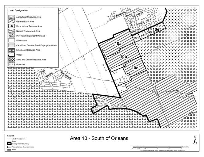
Evaluation – Area 10
|
Parcel ID
|
Gross ha
|
NHS feature
|
NHS areas removed
|
Limestone Resource
500m setback
|
Landfill 500m
setback
|
Other constraints
|
Notes re other
constraints
|
Gross ha
developable
|
|
10a
|
88.7
|
|
|
|
|
10.0
|
floodplain
|
78.7
|
|
10b
|
88.8
|
|
|
|
|
9.0
|
Floodplain and NDC
existing development
|
79.8
|
|
10c
|
88.6
|
Woodland
|
4.0
|
|
|
30.0
|
Notre-Dame-des-Champs
village
|
54.6
|
|
10d
|
8.3
|
|
|
|
|
|
|
8.3
|
|
10e
|
19.9
|
|
|
|
|
|
|
19.9
|
|
Sub-total
|
294.3
|
|
4.0
|
0.0
|
0.0
|
49.0
|
|
241.4
|
|
Criteria
|
Area 10 - Infrastructure
|
|
1. Water
|
The water supply (existing
and proposed) to Area 10 in Pressure Zone 2E is very good and no specific
upgrades to any existing or proposed piping or pumping would be required.
|
|
2. Wastewater
|
Given the close proximity
of the area to the Tenth Line PS and the downstream trunk sewers (500 m
downstream), Area 10 would be most appropriately serviced by the Tenth Line
PS. Servicing of Areas 10a and 10d, e will be limited to an upgrade of the
Tenth Line PS. Inclusion of Areas 10b and 10c will also require an upgrade to
the Orleans-Cumberland Collector.
|
|
3. Stormwater
|
All the parcels are in the
McKinnons Creek watershed. No subwatershed plan is available to guide
development. Area 10a is constrained by McKinnons Creek which bisects the
area, requiring two separate SWM facilities to service, and the area also
includes floodplain constraints. However the outlet from stormwater pond
servicing an adjacent urban area may be able to accommodate area 10a.
Drainage of all sites is poor due to flat topography. Servicing the area
would require constructing a storm trunk outlet 1-2 km downstream of Mer
Bleue Road to establish a sufficient gravity outlet. Poor soils (Leda clay)
exist in some areas, and could limit potential to resolve HGL constraints by
filling alternative sites.
|
Transportation
The Transportation Master
Plan seeks to provide a sufficient peak hour directional capacity to achieve a
Level of Service “D” for screenlines outside of the City’s inner core. Based
on this standard the future road capacity across the Bilberry Creek screenline
(#45), Innes Road screenline (#47) and the Greens Creek screenline (#16) can
accommodate this growth.
|
|
Criteria`
¯
|
Area 10a
|
Area 10b
|
Area 10c
|
Area 10d
|
Area 10e
|
|
Water
|
1
|
8
|
8
|
8
|
8
|
8
|
|
Wastewater
|
2
|
4
|
2
|
2
|
4
|
4
|
|
Stormwater
|
3
|
4
|
0
|
0
|
4
|
4
|
|
Road
Capacity
|
4
|
6
|
6
|
6
|
6
|
6
|
|
Arterial
& Collector Road Frontage
|
5
|
10th Line
|
10th Line
|
10th Line
|
10th Line
|
none
|
|
5
|
Mer Bleue
|
Mer Bleue & Wall
|
Wall
|
-
|
future collector to
north
|
|
Arterial-Collector
Frontage Score
|
5
|
6
|
6
|
6
|
4
|
2
|
|
Distance
to Rapid Transit
|
6
|
1.8
|
2.4
|
3.3
|
2.0
|
2.0
|
|
Transit
Score
|
6
|
8
|
6
|
4
|
8
|
8
|
|
Distance
to Mainstreet or MUC
|
7
|
1.3
|
2.3
|
3.2
|
2.2
|
3.2
|
|
Mainstreet
Score
|
7
|
5
|
5
|
4
|
5
|
4
|
|
Jobs-Housing
Balance
|
8
|
0.89
|
0.87
|
0.86
|
0.85
|
0.85
|
|
Jobs-Housing
Balance Score
|
8
|
0
|
0
|
0
|
0
|
0
|
|
Distance
to Major Recreational Facility
|
9
|
4.0
|
4.6
|
4.9
|
3.5
|
4.4
|
|
Major
Rec Facility Score
|
9
|
2
|
2
|
2
|
3
|
2
|
|
Emergency
Services POLICE
|
10
|
5.8
|
6.4
|
6.7
|
5.3
|
6.2
|
|
Emergency
Services FIRE
|
10
|
1.6
|
1.0
|
0.7
|
0.9
|
1.8
|
|
Emergency
Services AMBULANCE
|
10
|
1.2
|
1.9
|
2.7
|
2.2
|
3.2
|
|
Emergency
Services AVERAGE
|
10
|
2.9
|
3.1
|
3.4
|
2.8
|
3.7
|
|
Emergency
Score
|
10
|
4
|
4
|
4
|
4
|
3
|
|
Connectivity
|
11
|
4
|
3
|
3
|
2
|
2
|
|
Local
bus
|
12
|
0
|
0
|
0
|
0
|
0
|
|
Agricultural
land adjacent
|
13
|
20
|
55
|
70
|
32
|
97
|
|
Agricultural
land adjacent Score
|
13
|
0
|
0
|
0
|
0
|
0
|
|
Country
Lot or Landfill adjacent
|
14
|
none
|
NDC village
|
NDC village
|
none
|
none
|
|
Country
Lot or Landfill adjacent Score
|
14
|
4
|
0
|
0
|
4
|
4
|
|
Depth
to Bedrock
|
15
|
over 5
|
over 5
|
over 5
|
over 5
|
over 5
|
|
Depth
to Bedrock Score
|
15
|
2
|
2
|
2
|
2
|
2
|
|
Urban
Land Supply Score
|
16
|
8
|
8
|
8
|
8
|
8
|
Candidate Area for urban boundary
rationalization
Area 11 – East of Orleans Urban Area
|
Location: East of Cardinal
Creek and the east boundary of the Orleans Urban Area
|
OP Designation:
General Rural Area
Rural Natural Feature
|
Current Land Use(s): agriculture, commercial nursery, boat storage,
scattered development.
|
|
Size:
Gross ha = 315 ha
Gross developable ha = 200
ha
|
Zoning:
RU – Rural Countryside
RI 5 – Rural Institutional
RR – Rural Residential
EP – Environmental
Protection (along creek)
O1 – Open Space
|
|
Planning Status:
No applications
|
Adjacent Land Use
designations:
Urban Area in the west;
Agricultural Resource Area in the south, and General Rural Area in the east.
|
Adjacent Land Use(s):
Cardinal Creek to the west;
Ottawa River to the north;
Country lots to the east;
Agriculture to the south
|
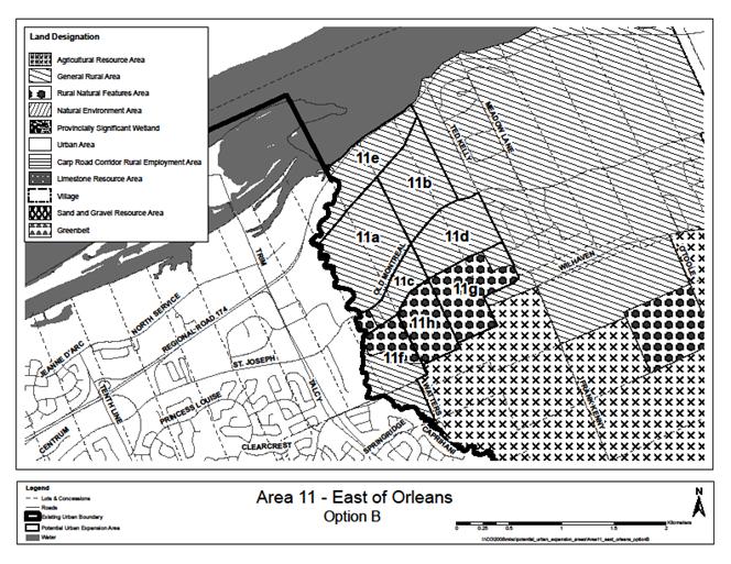
Evaluation
– Area 11
|
Parcel ID
|
Gross ha
|
NHS feature
|
NHS areas removed
|
Limestone Resource
500m setback
|
Landfill 500m
setback
|
Other constraints
|
Notes re other
constraints
|
Gross ha
developable
|
|
11a
|
62.7
|
Valleyland
|
17.0
|
|
|
|
|
45.7
|
|
11b
|
44.2
|
Woodland-Escarpment
|
11.0
|
|
|
|
|
33.2
|
|
11c
|
19.8
|
Valleyland-Escarpment
|
9.9
|
|
|
|
|
9.9
|
|
11d
|
39.3
|
|
|
|
|
|
|
39.3
|
|
11e
|
38.9
|
Woodland, Valleyland
& Escarpment
|
17.0
|
|
|
5.0
|
174 ROW
|
16.9
|
|
11f
|
39.6
|
Woodland, Valleyland
& Escarpment
|
35.0
|
|
|
4.6
|
servicing
|
0.0
|
|
11g
|
43.5
|
Woodland
|
0.0
|
|
|
|
|
43.5
|
|
11h
|
26.8
|
|
15.0
|
|
|
|
|
11.8
|
|
Sub-total
|
314.7
|
|
104.9
|
0.0
|
0.0
|
9.6
|
|
200.2
|
Additional Comments:
Parcels 11g and 11h are designated Rural Natural Feature in
the OP but the owner has recently cut down most or all of the trees.
|
Criteria
|
Area 11 - Infrastructure
|
|
1. Water
|
The water supply (existing
and proposed) to Area 11 in Pressure Zones 1E and 2E is very good and no
specific upgrades to any existing or proposed piping or pumping would be
required.
|
|
2. Wastewater
|
With the exception of a
portion of Area 11e, the entire area can be serviced by gravity through an
extension of the Ottawa River Sub-Trunk to the Candidate Area Parcels. The
sewer extension would cross the creek with trunk sewers routed above the
creek culvert. Servicing all of Area 11e would either require a local PS or
the lowering of the trunk services, which would then necessitate a siphon or
pumped crossing of the creek. This latter option would result in higher
capital and operating costs. The evaluation is based on a portion of 11e not
being serviced .
|
|
3. Stormwater
|
Areas 11a, 11b, 11c, and
11d drain to Cardinal Creek, while Area 11e drains to the Ottawa River. The
Cardinal Creek subwatershed study is underway, but would need to be updated
to provide guidelines for development. All sites have good drainage due to
the comparatively steep topography. The greatest stormwater challenge
servicing the site would be providing erosion protection along steeply sloped
outlets. Engineering requirements, while challenging, are not expected to
involve more than conventional drainage systems.
|
Transportation
The Transportation Master
Plan seeks to provide a sufficient peak hour directional capacity to achieve a
Level of Service “D” for screenlines outside of the City’s inner core. Based
on this standard the future
road capacity measured across
of the Bilberry Creek screenline (#45) and the Greens Creek screenline (#16)
can accommodate this growth. The Bilberry screenline extends from the Ottawa
River south to near Wall Road and has capacity available in the south at Innes
Road, Des Épinettes Avenue and the
Blackburn Hamlet By-pass
extension and in the north at St. Joseph Boulevard and Jeanne d’Arc Boulevard.
Ottawa Road 174 will have an additional lane in each direction added between
Jeanne d’Arc and the Highway 417 split.
|
|
Criteria
¯
|
Area 11a
|
Area 11b
|
Area 11c
|
Area 11d
|
Area 11e
|
Area 11g
|
Area 11h
|
|
Water
|
1
|
8
|
8
|
8
|
8
|
8
|
8
|
8
|
|
Wastewater
|
2
|
8
|
8
|
8
|
8
|
8
|
8
|
8
|
|
Stormwater
|
3
|
6
|
6
|
6
|
6
|
6
|
6
|
6
|
|
Road
Capacity
|
4
|
3
|
3
|
3
|
3
|
3
|
3
|
3
|
|
Arterial
& Collector Road Frontage
|
5
|
Old Montreal
|
Old Montreal
|
Old Montreal
|
Old Montreal
|
174
|
none
|
none
|
|
5
|
-
|
-
|
-
|
Ted Kelly
|
-
|
Ted Kelly
|
-
|
|
Arterial-Collector
Frontage Score
|
5
|
4
|
4
|
4
|
6
|
4
|
2
|
0
|
|
Distance
to Rapid Transit
|
6
|
2.1
|
2.8
|
1.6
|
2.9
|
2.1
|
3.3
|
2.5
|
|
Transit
Score
|
6
|
8
|
6
|
8
|
6
|
8
|
4
|
6
|
|
Distance
to Mainstreet or MUC
|
7
|
4.0
|
4.8
|
3.7
|
4.9
|
4.7
|
5.4
|
4.5
|
|
Mainstreet
Score
|
7
|
3
|
3
|
3
|
2
|
3
|
2
|
3
|
|
Jobs-Housing
Balance
|
8
|
0.90
|
0.89
|
0.89
|
0.88
|
0.87
|
0.86
|
0.86
|
|
Jobs-Housing
Balance Score
|
8
|
0
|
0
|
0
|
0
|
0
|
0
|
0
|
|
Distance
to Major Recreational Facility
|
9
|
4.3
|
5.1
|
4.3
|
5.2
|
5.3
|
5.6
|
4.8
|
|
Major
Rec Facility Score
|
9
|
2
|
1
|
2
|
1
|
1
|
1
|
2
|
|
Emergency
Services POLICE
|
10
|
3.3
|
4.1
|
3.3
|
4.2
|
3.8
|
4.6
|
3.8
|
|
Emergency
Services FIRE
|
10
|
4.5
|
5.2
|
4.4
|
5.3
|
5.5
|
5.7
|
4.9
|
|
Emergency
Services AMBULANCE
|
10
|
5.3
|
6.0
|
5.2
|
6.1
|
5.8
|
6.5
|
5.7
|
|
Emergency
Services AVERAGE
|
10
|
4.4
|
5.1
|
4.3
|
5.2
|
5.0
|
5.6
|
4.8
|
|
Emergency
Score
|
10
|
3
|
2
|
3
|
2
|
3
|
2
|
3
|
|
Connectivity
|
11
|
2
|
2
|
0
|
2
|
2
|
2
|
0
|
|
Local
Bus
|
12
|
1
|
1
|
1
|
1
|
0
|
0
|
0
|
|
Agricultural
land adjacent
|
13
|
0
|
0
|
0
|
0
|
0
|
68
|
44
|
|
Agricultural
land adjacent Score
|
13
|
2
|
2
|
2
|
2
|
2
|
0
|
0
|
|
Country
Lot or Landfill adjacent
|
14
|
none
|
Ted Kelly
|
none
|
Ted Kelly
|
none
|
Ted Kelly
|
none
|
|
Country
Lot or Landfill adjacent Score
|
14
|
4
|
0
|
4
|
0
|
4
|
0
|
4
|
|
Depth
to Bedrock
|
15
|
over 5
|
2-5
|
over 5
|
2-5
|
2-5
|
2-5
|
2-5
|
|
Depth
to Bedrock Score
|
15
|
2
|
1
|
2
|
1
|
1
|
1
|
1
|
|
Urban
Land Supply Score
|
16
|
8
|
8
|
8
|
8
|
8
|
8
|
8
|
RECOMMENDED PARCELS FOR URBAN EXPANSION DOCUMENT
3
|
Item
|
OPA76
|
City recommended changes
|
|
269
|
Schedule A, Rural Policy
Plan, is hereby amended as follows:
1.
At another hearing,
2.
At another hearing ,
3.
Withdrawn,
4.
At another hearing,
5.
Withdrawn,
6.
At another Hearing,
7.
At another Hearing,
8.
At another Hearing,
9.
At another Hearing,
10.
At another Hearing,
11.
At another Hearing,
12.
At another Hearing,
13.
At another Hearing,
14.
At another Hearing,
15.
At another Hearing,
16.
At another Hearing,
17.
At another Hearing,
18.
At another Hearing,
19.
At another Hearing,
20.
At another Hearing,
21.
Approved by OPA
22.
At another Hearing;
23.
By changing
the designation for the lands shown on Schedule R44 to this amendment from
General Rural Area to “Developing Community
(Expansion Area)”
|
Approve as amended by
the following:
24.
by showing the proposed boundary of the ‘Urban Expansion
Study Area’ as shown on Schedule R34
25.
by showing the proposed boundary of the ‘Urban Expansion
Study Area’ as shown on Schedule R36
26.
by showing the proposed boundary of the ‘Urban Expansion
Study Area’ as shown on Schedule R37
27.
by changing the designation of the lands shown on Schedule
R38 from ‘Agricultural Resource Area’ to ‘Urban Area’ and to show the
proposed boundary of the “Urban Expansion Study Area”
28.
by changing the designation of the lands shown on Schedule
R45 from ‘General Rural Area’ to ‘Urban Area’.
|
|
270
|
Schedule B, Urban Policy
Plan, is hereby amended as follows:
1.
At another hearing,
2.
At another hearing,
3.
At another hearing,
4.
At another hearing,
5.
At another hearing,
6.
Addressed at another hearing,,
7.
Addressed at another hearing,
8.
Addressed at another hearing,
9.
Addressed at another hearing,
10.
Addressed at another
hearing ,
11.
Addressed at another hearing,
12.
Addressed at another hearing,
13.
Addressed at another hearing,
14.
Addressed at another hearing,
15.
By designating the lands shown
on Schedule R44 to this amendment as “Developing
Community (Expansion Area)”
|
Approve as amended by
the following:
16.
by changing the designation of the land shown on Schedule
R34 to ‘Urban Expansion Study Area’.
17.
by changing the designation of the land shown on Schedule
R36 to ‘Urban Expansion Study Area’.
18.
by changing the designation of the land shown on Schedule
R37 to ‘Urban Expansion Study Area’.
19.
by changing the designation of the lands shown on Schedule
R38 to ‘Urban Expansion Study Area’ and ‘Developing Community(Expansion
Area)’.
20.
by changing the designation of the land shown on Schedule
R45 to ‘Developing Community(Expansion Area)’.
|