Report to/Rapport au :
Comité des services de transport en commun
09 June 2009 / le 09 juin 2009
Submitted
by/Soumis par : Nancy Schepers, Deputy City Manager/Directrice
municipale adjointe,
Infrastructure Services and
Community Sustainability/Services d’infrastructure et Viabilité des
collectivités
Contact/Personne ressource: Vivi Chi, Manager/Gestionnaire,
Transportation Planning/Planification des transports, Planning and Growth
Management/Urbanisme et Gestion de la croissance
(613)
580-2424 x 21877, Vivi.Chi@ottawa.ca
REPORT
RECOMMENDATION
That the Transit Committee approve the Statement of Work for the Western LRT Corridor Planning and Environmental Assessment as detailed in Document 1.
RECOMMANDATION DU RAPPORT
Que le Comité du transport en commun approuve
l’énoncé des travaux relatif à la planification et à l’évaluation
environnementale du couloir Ouest de TLR, comme il est expliqué en détail dans
le Document 1.
BACKGROUND
The 2008 Transportation Master Plan (TMP) identified two LRT corridors west of the downtown: a rapid transit LRT corridor in the vicinity of the Ottawa River Parkway (ORP) as part of Phase 1 of the rapid transit network implementation and an at-grade, LRT route on Carling Avenue in Phase 2. The objective of the rapid transit LRT corridor is to provide high-quality transit service to southwest and west-end residents travelling to the downtown area. Carling LRT corridor was identified to provide easy access to communities and employment areas along the corridor and providing connection to the main Rapid Transit Network at Lincoln Fields and the Carling Station of the O-Train/proposed North-South LRT corridor.
On 28 November 2008, Council directed staff to commence work on the Environmental Assessment (EA) for the Western LRT rapid transit Corridor. Prior to initiating the consultant selection process for any EA, staff informs and seeks approval from Committee on the scope of work for the study. The study’s scope identifies the level of effort to undertake the work, and thus sets the study budget.
DISCUSSION
The Statement of Work (SoW) is described in Document 1. It outlines the tasks to be undertaken to complete the Planning and EA study, including federal EA requirements, for a rapid transit facility connecting the LRT corridor from the downtown to Baseline Station. Upon approval from the City’s Transit Committee, this SoW will form the basis for a Request for Qualifications (RFQ) to be issued by the City prior to a Request for Proposals (RFP).
The City could apply the new provincial EA regulation aimed at expediting EA approval for transit projects, taking advantage of the background work related to this project undertaken as part of the recent Transportation Master Plan (TMP) update. However, based on public feedback and comments from the National Capital Commission (NCC) during Transit Committee and Council’s deliberation of the TMP, the planning phase of this study is being expanded to re-assess the need and function of the two LRT corridors identified. It is proposed that all reasonable alternative corridors be examined from the Ottawa River Parkway to Carling Avenue, including an option of only one transit corridor serving the two functions (rapid transit and community transit functions). Once a rapid transit corridor is identified, the Study will examine a range of alternative design options, and identify both construction and operational impacts of the project on all aspects of the environment.
Ontario’s expedited EA process will kick in once the full planning effort is completed (needs/justification, alternative corridor analysis, alternative design options). As there is a requirement for Federal permits and property, and with the City pursuing Federal funding, the project must also comply with the requirements of the Canadian Environmental Assessment Act (CEAA). Since this project must satisfy both Provincial and Federal act requirements, a co-ordinated process will be undertaken to avoid unnecessary duplication.
The study area will span from Bayview Station in the east to Baseline Station in the southwest. The northern limit will be the Ottawa River and the southern limit is Carling Avenue. This study area considers the role of Bayview and Tunney’s Pasture, Lincoln Fields and Baseline Stations as transfer points.
It should be noted that there is an overlap between this study area and the current Ottawa Downtown Transit Tunnel (DOTT) Planning and EA Study which extends from Tunney’s to Blair to ensure that the Carling option is being considered.
Some tasks will require examination of a broader area beyond these limits in order to address environmental impacts; operational issues; to coordinate with relevant on-going studies and projects; and, to study and identify tie-ins to future network connections.
Key considerations for the Western LRT Corridor Planning and EA study include the following:
- Re-assessment of project need taking into account ridership potential for all feasible options and travel time savings
- Coordination with/incorporating the results of the ongoing LRT Technology review
- Integration with existing communities and planned land uses
- Potential to promote and
advance transit oriented development
- Visual, cultural landscape and heritage attributes
- Impact on green spaces and natural areas including the Ottawa River Parkway corridor, Ottawa River
- Access to pedestrian, cycling and multi-use pathway facilities
- Geotechnical conditions
- Urban environment / design
- Environmental
characteristics
- Capital and operating costs
- Construction phasing and detours
- Consultation with NCC; government agencies; adjacent communities and the general public
STUDY
TIMING
A
multi-disciplinary consultant team, comprised of engineers, planners,
architects and other relevant specialists will undertake this study. In accordance with established City practice
for the acquisition of services, a two-step process consisting of a Request for
Qualifications (RFQ) followed by a detailed Request for Proposals (RFP) will be
utilized.
It is
expected that it will take approximately 26 months (20 months for the planning
stage and six months for the EA stage) after contract award to complete this
study. These timelines are consistent
with industry practice for projects of this scope and complexity.
ENVIRONMENTAL IMPLICATIONS
The study will examine and evaluate the project’s effects on social, physical and natural environments within the study area. Appropriate mitigation measures will be developed and post mitigation environmental impacts will also be determined.
CITY STRATEGIC DIRECTIONS
The recommendations contained herein directly support the following Strategic Directions adopted by Council on 11 July 2007:
B3 Attain transit goals (30 per cent modal split) by 2021.
E9 Require walking, transit and cycling oriented communities and employment centres.
F4 Ensure that City infrastructure required for new growth is built or improved as needed to serve the growth.
CONSULTATION
This Statement of Work has
been prepared in collaboration with the National Capital Commission.
Consultation will be an
integral part of the EA process. The
City will work closely with the NCC to determine the most sustainable corridor.
The City will also involve a large number of stakeholders,
including community groups, property owners, approval agencies and special
interest groups. Early in the study
process stakeholders will be identified through various forms of consultation,
including liaison with City Councillors, Community Associations, approval
agencies and public notification.
Consultation
with the general public will occur principally through open house meetings, but
also through the project web page, e-mail and additional meetings as required.
LEGAL/RISK MANAGEMENT IMPLICATIONS:
There are no legal/risk Management impediments
to implementing this report's recommendation.
FINANCIAL IMPLICATIONS
Funding for the Western LRT Corridor Planning and Environmental
Assessment Study is available in Internal Order No. 905184 - Rapid Transit EA
Studies 2009.
SUPPORTING DOCUMENTATION
Document 1 Western Parkway LRT Corridor Planning and Environmental Assessment Study – Statement of Work
DISPOSITION
Following
Committee approval of the attached Statement of Work, the consultant selection
process will commence.
WESTERN LIGHT RAIL TRANSIT CORRIDOR
(BAYVIEW
TO BASELINE) PLANNING AND ENVIRONMENTAL
ASSESSMENT STUDY DOCUMENT 1
STATEMENT OF WORK
1.0 Introduction
The City of Ottawa is the proponent of a Planning and Environmental Assessment (EA) to study the proposed Western Light Rail Transit (LRT) Corridor project from Bayview to Baseline Station. This project is identified in the 2008 Transportation Master Plan (TMP) to be in the vicinity of the Ottawa River Parkway (ORP) corridor as part of Phase 1 of the rapid transit network implementation.
The TMP also identified Carling Avenue as an at-grade, east-west LRT route in Phase 2 of the TMP implementation, providing easy access to communities and employment areas along the Carling corridor and providing connection to the main Rapid Transit Network at Lincoln Fields and the Carling Station of the O-Train/ proposed North-South LRT corridor.
This Study will re-assess the need for the two LRT corridors, examine all reasonable alternative corridors including an option of only one transit corridor serving the two functions: rapid transit and community transit functions. Once a rapid transit corridor is identified, the Study will examine a range of alternative design options, and identify both construction and operational impacts of the project on all aspects of the environment. The EA will bring forward a recommended plan detailing the corridor alignment, location of stations, supporting infrastructure and all measures to mitigate environmental impacts. In addition, detailed costs, implementation timelines and all subsequent approvals required to proceed with the construction of the project will be identified.
This Statement of Work (SOW) describes the City’s intentions with respect to the methodology, public consultation and deliverables for this study. It outlines the tasks to be undertaken to complete the Planning and EA study, including federal EA needs, and upon approval from the City’s Transit Committee will form the basis for a Request for Qualifications (RFQ) to be issued by the City prior to a Request for Proposals (RFP).
2.0 Background
During the 1970s the former Region of Ottawa Carleton began a program to implement Bus Rapid Transit (the Transitway) in the region. This program led to the construction of the initial 31-km Transitway network extending from Baseline Station in the southwest to Blair Station in the east and from Hurdman Station to South Keys Station in the southeast. There are a few missing segments in the city’s Transitway network. Chief among them is that part of the Transitway between Dominion Station and Lincoln Fields Station. The present bus services on the Ottawa River Parkway in mixed traffic is a consequence of the absence of consensus on a permanent Transitway route through the western sectors of the city. One of the urban corridors parallel to the Parkway corridor, evaluated as part of Transitway planning by the former Regional government in the 1980s, is a former tramway corridor between Byron Avenue and Richmond Road that continues to exist mostly as a linear park, although the Richmond/Byron corridor is now experiencing infill development.
Since the completion of these initial sections, several extensions of the Transitway have been implemented and an O-Train service between Greenboro and Bayview Stations has been introduce. Ridership has reached more than 120 riders per capita – highest in North America of comparable-size cities. This success, however, has led to the system reaching its capacity in the downtown area and has contributed to congestion problems and reliability issues especially in the winter months.
On 28
November 2008, as part of the Transportation Master Plan (TMP) discussion,
Council approved a new rapid transit plan that calls for the construction of an
LRT tunnel in the downtown core and the conversion of the existing Transitway
to LRT between Blair and Baseline stations.
On the same date, Council approved the expansion of the scope of work
for the Ottawa Downtown Transit Tunnel (DOTT) EA to include an extension to
Tunney’s Pasture and Blair Station.
Council also directed staff to commence the work on the EA study for the
Western LRT Corridor.
At present, on the section between Bayview and Baseline Station, buses use an exclusive grade-separated Transitway between Bayview and Dominion Stations (3.6km), then run on the Ottawa River Parkway (ORP) in mixed traffic between Dominion and Lincoln Field Stations (4.0km), then use the exclusive grade-separated Transitway section from Lincoln Fields to Baseline Station (3.0 km). The transit operation on ORP started in 1974 and has been subject to several legal agreements with the National Capital Commission. The latest agreement extended the City’s right to use the Parkway to 2031, for an annual payment by the City.
The ORP is a distinct part of some 90 kilometres of scenic parkways in the Capital Region. It is one of the most popular and scenic parkways in the Capital. It opened in 1961 as a prime example of the parkway movement of the early 20th century with an objective of bringing the natural and human environments into closer harmony and showcase the outstanding natural and urban shorelines of the Capital for residents and visitors alike. Its distinctive character is defined by unique alignment, constitution of the corridor setting, roadside treatment, grades, commercial vehicle prohibition, signage standards, and lighting restrictions.
The ORP has evolved from being a
scenic route to also becoming an important commuter artery for southwest and
west-end residents travelling to the downtown area by private vehicles or
public transit, particularly government employees who work at the Tunney's
Pasture office complex, and other areas. About 140 buses
per direction currently use the Ottawa Parkway during the peak hour (a bus
every 25 seconds – September 2008 data).
The ORP continues to be closed to automobiles and opened to pedestrian
and non-motorized traffic every Sunday between May and September.
3.0 Planning Context
A number of planning, heritage, environmental, transportation and landscape studies and policy initiatives undertaken by the NCC and the City of Ottawa will influence and inform this study. These studies and initiatives are described below:
The 1999 NCC Plan
for Canada’s Capital identified “Integrated Transportation and Communities”
as one of the key important Capital Planning Principles. The plan supports affordable, accessible and
integrated transportation networks within Canada’s Capital Region and between
the Capital and the rest of the world.
The Plan stresses that Capital destinations, facilities and events
should be accessible through the use of a transportation network that can serve
public transit users, pedestrians, cyclists and drivers – both visitors and
residents alike. The plan also defines the role of parkways as
fundamental instruments to communicate the green quality and image of the
Capital, as essential venues for public events and celebrations, and as key
picturesque channels that influence public perception and communicate the green
image and landscape of the Capital.
The NCC Strategic Transportation Initiatives White Paper defines the NCC strategies in support of sustainable urban transportation. It identifies NCC perspective for moving from a transportation system dominated by low occupancy car use to a more balanced transportation system, where the contribution of integrated land use and transportation geared toward the long-term reduction of greenhouse gas emissions is recognized, and where public transportation and alternative transportation options are given preference and made to succeed.
The 2005 NCC’s Ottawa River Parkway Corridor Visual Character Assessment and Analysis Study, represents a comprehensive landscape analysis of the Ottawa River Corridor focusing on its desired visual character, and identifies its key Capital gateway functions, views, and associated land requirements.
The NCC has embarked in 2007 on the Capital Urban Lands Master Plan process. The purpose of this plan is to define a vision, strategic orientations, guidelines and development proposals for Capital Urban Lands in order to enhance their contribution to the experience and unique living environment of Canada’s Capital. The plan process will be conducted in two phases with completion in 2011.
An evaluation of the 1999 NCC Plan for Canada’s Capital was launched in 2008 to determine the scope of the full plan review, which is expected to cover a broad range of subjects and issues, and will include an expanded section or emphasis on sustainable transportation in the NCR, and on environmental sustainability affecting all areas of federal interest in the Capital. The plan review is expected to be completed by 2013.
The City's Official Plan sets out a growth management strategy that
emphasizes urban intensification and increased mix-use development at key
locations along rapid transit corridors.
The completion of the 5 year review of the Official Plan will see the
addition of new policies, as required by the Provincial Policy Statement, to
identify and promote opportunities for intensification and redevelopment by way
of setting minimum targets within built up areas. In the study area this would apply to the Mixed-Use Centres of
Tunney’s Pasture and Bayview-Preston and to the Arterial Main Street of Carling
Avenue.
In 2007 Council approved the Richmond Road/Westboro Community Design
Plan (CDP), which foresees substantial growth from intensification in this
corridor during the next two decades. A
40% transit modal split target was set out in the CDP.
4.0 Major Issues to be
Addressed
When
assessing alternative corridors, a wide variety of factors will be examined,
including but not limited to:
§
Need
Assessment;
§
Ridership
potential;
§
LRT
technologies;
§
Roles
as mass mobility system and as community building and regeneration catalyst;
§
Potential
to promote and advance transit oriented development;
§
Community
access and land use integration;
§
Congestion
reduction;
§
Visual,
cultural landscape and heritage attributes;
§
Environmental
characteristics;
Some of
the major issues are presented below. Although they are discussed
independently, most of these issues are closely related to each other, and
their interdependence will have a direct bearing on the study findings and EA
recommended plan.
4.1 Need Assessment
Each of the alternative corridors poses different challenges. Using the most current information and technical data available, this study will identify existing and future transit demand (in the area and along the alternative corridors) and document opportunities and challenges within the Study area. The study will analyze the need and justification for LRT corridor(s) to provide rapid transit and community transit functions. The study will also quantify benefits to transit riders for each of the alternative options.
4.2 LRT Technologies
A separate
LRT technology review is being undertaken to evaluate potential technologies that would be suitable for Ottawa’s LRT
system. A range of key technology selection issues will be examined including
power collection system (overheads versus catenary-free operation), degree of
separation, winter operating and maintenance consideration, driver operated
versus automated trains, single versus multiple vehicle technology. A decision on recommended LRT technology characteristic
is expected to be reached by the end of Summer 2009.
The EA
study will consider and identify issues associated with the recommended LRT
technology including constraints
and opportunities, the
requirement for transfer points, station locations and platform configuration,
supporting infrastructure requirements, access to stations, accessibility to
the Ottawa River and pathways, aesthetics, safety and security.
4.3 Corridor Design and Station Integration
The selection of a preferred corridor and alignment will be based on a comprehensive examination of alternative routes and the feasibility of implementing an LRT facility in a constrained and built-up area which will have an impact on the surrounding environment for pedestrians, cyclists, and residents. Therefore, corridor and station location and design will have to address a host of issues including but not limited to:
· Integration with and access by adjacent communities, businesses and employment areas
· Effect on adjacent communities (unifying or divisive effects)
· Effect on the Ottawa River Parkway
· Integration with the existing pedestrian environment, including safety and access considerations
· Effect on designated cycling and multi-use pathway routes
· Air quality, noise and vibration
· Aesthetic, urban design, views and vistas
· Potential displacement of vehicular traffic
· Impact on overhead and underground utilities and services
· Construction and operational costs, phasing and operational issues
5.0 Guiding Principles
Principles that will guide the
perspectives and approach in this study include, but are not limited to the
following:
·
Connecting places and communities by providing convenient service to and
from places where people live, play and work – where the emphasis is on serving
communities, advancing transportation land use goals, and promoting transit and
active transportation opportunities;
·
Service that complements and does not diminish the
character and quality of the corridors and communities with importance placed
on context sensitive and innovative, high
quality and green urban design approaches;
·
Respect
for the integrity of the natural environment, cultural and heritage traits that
showcase the City and the Capital;
·
Economic
vitality where the economic health of the study area and the Capital are
improved through enhanced mobility and access, promotion of active transport, densification, transit-oriented
development opportunities, and where adverse impacts on property values are minimized; and,
·
Early, ongoing, inclusive and transparent stakeholder and public
engagement whereby information exchange and interactive process promoted
a high level of meaningful participation in the identification, evaluation,
selection and design of a corridor, route and stations.
6.0 Project Scope and Major
Tasks
6.1 General
As the City is the proponent for this undertaking, this project is subject to the Ontario Environmental Assessment Act (OEAA). The project must also comply with the requirements of the Canadian Environmental Assessment Act (CEAA) considering the potential implication of federal and NCC properties, the potential requirements for Federal permits and funding. Since this project must satisfy both Provincial and Federal Act requirements, a co-ordinated process will be undertaken to avoid unnecessary duplication.
In addition, the Ontario Secretariat for Aboriginal Affairs and Indian
and Northern Affairs Canada will be contacted to review any First Nations
issues or ongoing claims within the Study area. Recognizing the federal role in
this regard, the Study will ensure appropriate coordination with federal
authorities pursuant to the 2008 federal guidelines on “Aboriginal Consultation
and Accommodation”. Direct consultation with affected First Nations will also
be carried out as appropriate.
6.1.1 Study
Area
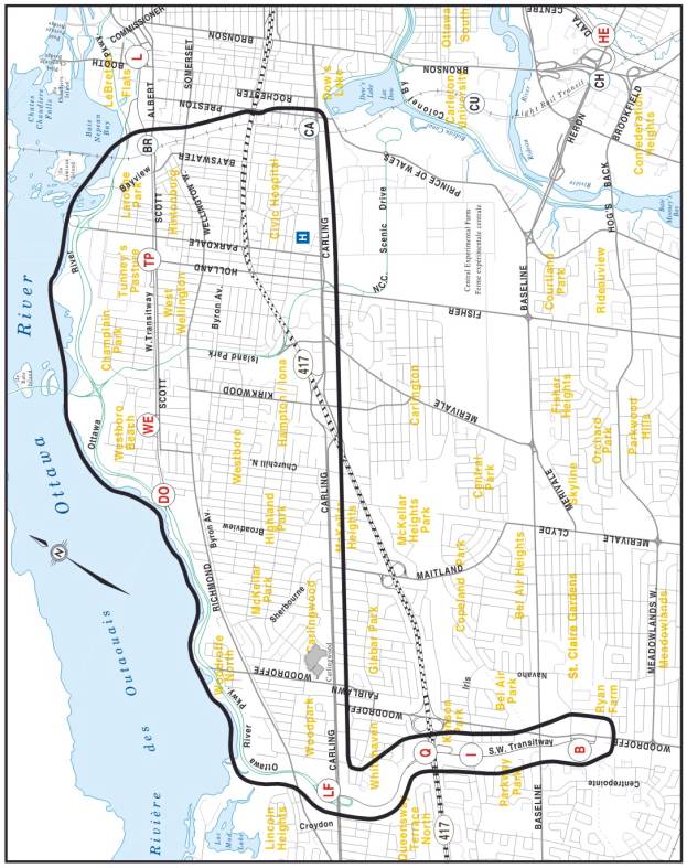
To ensure that all options are being considered, the study area (Figure 1) has been expanded easterly to Bayview and southerly to Carling Avenue. The study area highlights consideration of the roles and functions of Bayview, Tunney’s, Lincoln Fields and Baseline Stations as transfer points.
Some tasks will require examination of a broader area beyond these limits in order to address environmental impacts; operational issues; to coordinate with relevant on-going studies and projects; to study possible future network connections. Therefore, the study area will be confirmed early in the study process, informed by consultation with stakeholders and the public.
Figure 1 Study Area
6.1.2 Timing
The City recognizes that time is needed to fully consult with the National Capital Commission as well as to engage in a significant public outreach and consultation with surrounding communities. Therefore, it is estimated that this Study could be completed within 24 months from the award of the contract.
6.1.3 Co-ordination with other Studies
The study
will be informed by and take into consideration any information including
analysis and findings of past and concurrent transportation, planning and
infrastructure studies and projects that could that could have relevance to
this study. They include, but are not
limited to:
· Downtown Ottawa Transit Tunnel: Tunney’s Pasture to Blair Station Planning and Environmental Assessment Study
· Richmond Road/Westboro Community Design Plan
·
Development Plan and Strategy For
Centrepointe
·
Richmond/Westboro Transportation
Management Plan
· Former City of Ottawa Preston-Champagne Secondary Plan
6.2 Planning and Environmental Assessment
6.2.1 Study Design
A Study Design will be developed to ensure
that all aspects of the environmental assessment will be properly
addressed. Part of this task will be to
work closely with the NCC and liaison with Provincial and Federal authorities
responsible for environmental assessment review.
The Study Design report represents the
study’s perspective and is subject to changes and refinements as the project
proceeds and in response to comments received throughout the consultation
program. The Study
design will be made available at all public Open Houses and on the City’s
project web site.
The Study Design will:
·
Describe
the purpose of the undertaking
·
Confirm
the study area
·
Describe
the approach, methodology and tasks to complete this assignment, including a
plan for development of alternative corridors/alignments as well as a process
for evaluating these alternatives
·
Set
out the study consultation program
·
Define
the membership, roles and responsibilities of consultation groups and identifies all project stakeholders
·
Identify the administrative structure
of the Study
·
Set out study schedule highlighting
major milestones and decision-making steps
·
Description
of the EA process for the proposed project, including:
- description of the EA process;
- commitment to a formal
consultation program;
- description of the studies
to be undertaken by experts in specific areas related to the
environmental assessment process; and,
- documentation that will be
produced as a result of this Study.
6.2.2 Need and Justification
for the Project
In order
to expedite sustainable transportation solutions, Ontario’s new EA Regulation
for transit allows the City to rely on relevant past analyses (such as the 2008
TMP) to justify public transit projects.
However, due to public concerns raised during the TMP update, this Study
will not take advantage of the new transit EA Regulation and will begin with a
review of the need to expand LRT services westerly to serve west and southwest
residents inside and outside the greenbelt.
The key components of this stage include:
·
Identifying
and assess all future travel demand including transit ridership within the
Study area
·
Identifying
current and projected transportation problems and opportunities within the
study area
·
Identifying
the quality and capacity of transit service that is required to achieve transit
ridership and transit modal split targets as well as promote opportunities for
intensification and redevelopment
·
Identifying
the infrastructure (one or more corridors) required to provide the appropriate
level of transit service to achieve these goals
6.2.3 Environmental
Inventory/Existing Conditions
An
inventory of the existing social, economic, physical and natural environments
within the study area will be compiled. The inventory will consider all available
background material and where necessary, supplement this information through
on-site surveys and/or detailed studies. The inventory must be of sufficient
detail to enable the analysis of all alternatives considered in this study.
In
general, the inventory will identify and describe those aspects of the
environment that could potentially affect, or be affected by, the undertaking.
Some of the specific aspects of the environment associated with this project
include:
· Green spaces and natural areas including the Ottawa River Parkway corridor, Ottawa River and its accessory watercourses;
· Urban environments
· Noise and vibration
· Current and future pedestrian, cycling and multi-use pathway corridors
· Utilities including water, storm and sanitary drainage, hydro, gas, bell, cable, etc.
· Subsurface (geotechnical) conditions
· Heritage and archaeological conditions
Comments received from the public, consultation groups and other stakeholders will be used to refine the inventory. The complete inventory will be clearly described and documented within the Environmental Inventory/Existing Conditions Interim report and the Environmental Project Report (EPR).
6.2.4 Evaluation Criteria and
Evaluation Process
A comprehensive evaluation criteria and methodology to evaluate the
various alternative corridors and alternative designs will be developed. The inventory of existing conditions will
define the scope of impacts on the environment that will need to be examined to
determine the technically preferred corridor(s).
Factors that are consistent with the goals and objectives of this study
will be identified to conduct the evaluation of alternatives. The criteria will include but not limited
to:
q
Transportation – To assess how alternative
corridors could satisfy TMP mobility and modal split objectives, including but
not limited to the following criteria:
·
Ridership
potential;
·
Travel
time savings;
·
User
benefit
·
Connections
to existing and future transit services;
·
Traffic
and congestion reduction;
·
Efficiency
of transit operations;
·
Opportunities
for interprovincial transit connectivity
·
Compatibility with existing and planned pedestrian and cycling networks
and facilities
q
Land
Use – Conformity
with NCC and the City of Ottawa land use policy directions using measures such
as service to key employment areas, integration with
surrounding community, contribution to community revitalization and transit-oriented
development opportunities, amount of existing residential and commercial developments as well as
amount of developable land within the corridor or station location.
q
Environmental – to assess the potential
effects of alternatives on the natural and physical environment
q
Social – to assess the potential impact
on nearby and adjacent neighbourhoods, communities and facilities, including
noise and vibration impacts (during and post construction), Green House Gas
(GHG) emission, and potential land and property requirements. City and NCC urban design and planning objectives, heritage and archaeological
features, First Nation land claims, and community access to transit.
q Compatibility – Extent of conformity with City
of Ottawa plans and strategies, compatibility with NCC plans and strategies
including:
·
City
of Ottawa Official Plan;
·
City
of Ottawa Transportation Master Plan;
·
NCC
Plan for Canada’s Capital;
·
NCC
Capital Urban Land Master Plan;
·
NCC
Parkways Policy; and,
·
NCC
Strategic Transportation Initiative White Paper.
q
Economic
– Potential for
rapid transit to act as a catalyst for new development and redevelopment in the
study area
q
Financial
– to assess
cost-effectiveness by estimating factors such as operating cost per passenger,
total capital cost, total capital cost per new rider, operating cost, fiscal
capacity, benefit cost analyses
q
Implementation
– Ease of
implementation, including constructability consideration, property right-of-way
acquisition issues, and other constraints and issues that could delay
implementation
The evaluation process will be clearly described and documented. Comments received from the public, consultation groups and other stakeholders will be used to refine the evaluation criteria.
6.2.5 Identify and Evaluate
Alternatives Corridors
Possible
alternative rapid transit corridors include:
· Expand rapid transit (LRT) on the Ottawa River Parkway corridor
· Expand LRT using Byron/Richmond corridor
· Expand LRT using O Train/Carling corridors
· Combinations of the above-noted alternatives
The alternative corridors will be evaluated relative to the status quo whereby transit service conditions are retained, based on the previously discussed criteria. The results of this analysis will be presented to the NCC, study stakeholders, Consultation Groups, government agencies and public for review and comment at the first Public Open House (POH) prior to formulating a recommendation on the preferred corridor. An interim report on the preferred corridor will be presented to the Transit Committee for approval.
6.2.6 Develop Alternative
Alignments/Designs
Following
the identification of the preferred corridor, various design alternatives will
be identified and evaluated. Detailed
alignment and cross-section design alternatives, including station locations
and layouts will be identified based on a consideration of any constraints
within the study area, input from the Study Team, NCC, key stakeholders,
Consultation Groups, the public and government agencies, and accepted rapid
transit guidelines, standards, and practices.
All proposed designs will include associated modifications to existing
crossing/connection roadways as required.
The
various alternative designs will consider:
· Landscaping and urban design features
· Station locations and layouts
· Station integration opportunities
· Geotechnical considerations
· Grade separations and structural general arrangements
· Power and electrical supply
· Utility location and relocations
· Stormwater management
· Safety and security
· Operation considerations
· Constructability and staging
Additional
field investigations, surveys, test pits and boreholes as necessary to document
the scope and potential impact of the design alternatives will be undertaken.
Alignment alternatives will consider horizontal plan and vertical profiles.
6.2.7 Evaluation of Alternative Designs
The
study will clearly identify the initial impacts of each alternative design as
well as the net post-mitigation impact as well as enhancement opportunities
using quantifiable indicators and measures wherever possible. To ensure that all impacts are appropriately
evaluated, the following topics will be covered in detailed environmental
impact studies:
·
Transportation
Service and Existing Infrastructure:
o
Impact
on transit travel times and variability
o
Impact
on transit ridership
o
Impact
on pedestrian and cycling network, environment, security
and accessibility
o
Impact
on vehicular traffic
o Impact on utilities
·
Natural
Environment:
o
Impact
on green space and urban natural environment
o
Impact
on groundwater and surface storm water drainage
o
Impact
on local and global air quality
o
Impact
on greenhouse gas emissions
o
Impact
of contaminated lands
·
Social
Environment:
o
Urban
design including landscape, streetscape plans and station design
o
Impact
on adjacent land uses, including access and loading activities
o
Health
care cost impact of air quality
o
Impact
on First Nation traditional use of lands
o
Impact
on noise and vibration levels
o
Safety
and security
o
Heritage
and archaeological matters
·
Economic
Environment:
o Impact on local businesses
o Impact on transit revenues and operating costs
o Impact on property taxes, development charges and other municipal financing functions
o Impact of air quality on health care cost
The results of the evaluation will be presented at the second Public Open House (POH).
6.2.8 Recommended Plan
Following
the evaluation of the alternative designs using the above-noted detailed
evaluation criteria, and after determining all necessary mitigation measures to
minimize any adverse impacts of the project, the study team, with input from
key stakeholders, the Consultation Groups, landowners and review agencies, will
select and document a preferred alternative design, which will be
presented at a final Open House.
Upon
receipt and incorporation of public feedback, the preferred alternative
design will then be developed to a sufficient level of detail as
required to produce a functional design plan that is adequate for submissions
for project approvals in principle and to establish a complete scope of work,
baseline budget and implementation schedule for the entire project. This
Recommended Plan will incorporate the functional design plan and will include
but may not necessarily be limited to:
q A written description of the undertaking including the design parameters
q Functional design drawings (1:500 scale, plan and profile) for the preferred alignment with geo-referenced horizontal alignment; vertical profile; grading; drainage; property envelope;
q Cross-section drawings for typical sections as well as critical areas;
q Landscape and urban design plans;
q Vehicle technology
q Storm water management requirements
q Property needs/acquisition plan Implementation (staging) plan and detour plan during construction;
q Signal and communication infrastructure requirements
q Electrical power supply infrastructure requirements
q Infrastructure implementation/staging plan (i.e. municipal servicing, utility coordination, rehabilitation of roads, etc.)
q Potential mitigation measures, with a commitment to compliance monitoring during project implementation
q Project
baseline budget in approved WBS format
The Recommended Plan, including mitigation measures, will clearly identify and set out the requirements and timing for all subsequent approvals required to proceed with construction of the project. This plan will be presented to the NCC’s Advisory Committee on Planning, Design and Realty (ACPADR) for comments and advice. Information will be provided to NCC staff for presentation to the NCC Board. The recommended plan will be presented to the Transit Committee and Council for approval.
7.0 Federal Requirements
7.1 Federal EA Project Description Report
The transit
route could be running through NCC lands. Also, federal permits, and funding
are most likely required before project implementation can proceed. In order to expedite the future federal
approval processes, the City and Study consultant will initiate discussions
with the relevant federal Responsible Authorities (RAs) to identify all federal
EA requirements and initiate the federal EA screening process. This will ensure
that all relevant existing environmental inventory data collected and impact
assessments carried out during this assignment are scoped sufficiently to
address federal EA screening requirements.
A Project
Description Report will be prepared in accordance with the requirements of the
federal RAs. The report will include enough information on potential impacts,
mitigation measures and conceptual compensation strategies to allow the federal
agencies to conclude on the significance of environmental effects at this early
planning stage.
7.2 Federal Screening Report
Upon
completion of the Study, and in addition to the EPR, a Federal Screening Report
will also be prepared. The Report will be of sufficient scope to address the
federal screening requirements. It will
document the proposed project and summarize all stages of the study process
leading to the development of the final recommended plan for the Project.
8.0 Project Deliverables
The deliverables for the study include:
q Study
Design, including project scope, alternatives, evaluation criteria and
methodology, consultation and communications plan;
q Project Need and Assessment Report
q
Draft and Final Ontario Environmental Project
Report (EPR)
q Environmental Inventory/Existing Conditions Report
q
Recommended Plan
q
Federal EA Project Description Report
q
Federal screening report
q
Project Ridership and Business Case Reports
q Project capital and operating cost estimate, including baseline budget, in Work Breakdown Structure (WBS) format
q Noise, Vibration and Air Quality Report
q Geotechnical Report
q Consultation Summary Report
q
Written and graphical content for all public
notices related to the study
q Public Open House and Consultation Group presentation display and information materials, handouts, signage, etc.
q Project Web Page data
q
Project Update Newsletter – minimum of
three
q Functional design drawings (1:500 scale) of the recommended plan, including plans and profiles for recommended alignments, station layouts and elevation drawings, structure general arrangement drawings, utility relocation details, storm water management plans, landscape design plans, supporting infrastructure and property requirement plans
q Project Implementation/Staging Plan, which shall identify all future approval requirements including those for property acquisitions and easements and other property related matters
8.1 Environmental Project Report
Under
Ontario’s proposed new EA Regulation, an Environmental Project Report (EPR) has
to be prepared and completed within the legislated timeframe for transit
EAs. A Draft and Final EPR will be
prepared to document the entire study process including consultation, the
recommended design and any appropriate mitigation plans, amending procedure,
costing, and implementation and staging plan, and commitments to future action,
including external approvals known to be required.
The final EPR,
incorporating all pertinent comments, will be prepared and placed on public
record for a minimum 30-day review period.
8.2 Ridership
Future
ridership projection will be developed as part of this EA. The ridership study will develop peak hour
and all day ridership projections for the years 2021 and 2031 for the
alternative corridors. It is expected
that this data will feed directly into the EA analysis. The analysis and refinement of ridership
projections will be used as input to the selection of the preferred solution
and for the project business case report.
8.3 Project Business Case Report
The Consultant will prepare a detailed Project Business Case report to support Federal and Provincial funding applications in compliance with all funding agency requirements. The report will incorporate detailed Planning and EA study findings such as ridership projections, capital costs, operating and maintenance costs, impact on travel time for transit and auto users in the corridor, environmental costs related to vehicle emissions, and others as input to a socio-economic benefit-cost analysis evaluation using specialized software, such as ‘TransDEC’ or approved equivalent, as mandated by the funding agencies. The Business Case Report should take into account the benefits to transit system users all across the network
8.4 Costing
Developing an accurate project baseline budget is an essential component of this study, as it will contribute to the City’s capital budget forecasting and priority setting, and shall form the basis for project funding applications to senior governmental levels.
The baseline budget will be structured in approved WBS format in accordance with the City’s standard Program Management System. The WBS will include detailed scope statements for all major project elements, which will be identified on a WBS diagram, and will identify all items and their costs required to complete the undertaking, including operating and maintenance costs. The baseline budget will include contingency allowances and escalation costs and will identify cash flow projections based upon estimated project implementation timelines.
9.0 Consultation
This study
will involve a large number of stakeholders, including City Advisory
Committees, community groups, property owners, businesses, approval agencies and
special interest groups. Early in the study process stakeholders will be
identified. This will be accomplished through various forms of consultation,
including liaison with Ward Councillors, property owners, community and
business associations, government agencies and public notification.
The consultation program will primarily consist of meetings with stakeholders, individually and through Consultation Groups, and meetings with the general public through Public Open Houses. Consultation Groups will meet with the Study Team at key stages to review and comment on specific issues, the study progress and findings. Notes of all meetings, individual or group, will be documented and form part of the EA process. The three Consultation Groups are:
q Public Consultation Group (PCG)
q Agency Consultation Group (ACG)
q Business Consultation Group (BCG)
The membership, roles and responsibilities of each Consultation Group will be defined prior to meetings taking place.
Specific aspects of the consultation program are detailed as follows.
9.1 Public Consultation Group
A Public Consultation Group (PCG) will be formed to enable community/special interest groups and adjacent property owners to provide direct input to the study, advising and commenting on local issues and concerns. Membership of this group will be determined in consultation with affected ward councillors.
9.2 Agency Consultation Group
An Agency Consultation Group (ACG) will be formed to
address the full range of technical issues and to comment on all of the special
studies required to fully assess the various alternatives and to ensure that
the City is following the procedures, legislation and addressing appropriate
policies. Members will include
representatives primarily from government agencies and approval bodies.
The ACG will meet at key stages throughout
the study. Direct one-on-one
consultation with other Agency groups may be necessary as specific issues arise
during the course of the study. Presentations to other groups such as the NCC’s
Advisory Committee on Planning, Design and Realty (ACPDAR) will be required and
will occur at key points during the study.
9.3 Business Consultation Group
A Business Consultation Group (BCG) will be formed to enable businesses owners and private sector property owners to inform and provide input to the study, advising and commenting on local economic and business issues and concerns. Membership of this group will be determined in consultation with affected ward councillors.
9.4 Notifications
The public will be notified of: the EA Study commencement, all Public Open Houses (POHs) and the submission of the EPR for Ministry approval. Notifications will be sent out at appropriate stages in the Study, and each announcement will take the following forms:
q Advertisements in daily newspapers (The Ottawa Citizen, Le Droit)
q The project web site on the City’s web portal
Additional notifications will be undertaken, as required, in accordance with provincial EA regulations.
9.5 Public Open Houses
The Public
Open Houses (POHs) will be held to present and obtain feedback on existing
conditions, alternative corridors, alternative design concepts, and the
recommended plan.
Background and
presentation material will include a “Project Update Newsletter” which will
summarize the information presented at the POH and will be available for
general distribution. Bilingual staff
will be present during all Public Open House meetings and all material
presented at the POH meetings as well as the “Project Update Newsletter” will
be in both official languages.
9.6 Project Web Page
A Project Information Web Page
will be established for this Study on the City’s external web portal. The purpose of the Web Page will be to
inform the public of the progress and interim findings of the study and
upcoming meetings or activities, and to provide a point of access for public
consultation and feedback.
9.7 Project Master Mailing List
A Master Mailing List for the project will be established at the study outset and updated throughout the course of the project. The Mailing List will be updated via Public Open Houses, general enquires, e-mails and other forms of consultation.
9.8 Presentations to NCC
Interim study findings at key milestones, conclusions and recommendations will be presented to ACPDR.
9.9 Transit Committee and
Council Meetings
The interim and final study findings will be presented to the Transit Committee and Council for approval.