Report to/Rapport au :
Comité des transports
and Council / et au Conseil
7 September 2005 / le 7 septembre 2005
Submitted by/Soumis par : Ned Lathrop, Deputy City Manager/Directeur
municipal adjoint,
Planning and Growth Management/Urbanisme et Gestion de la croissance
Contact Person/Personne
ressource : Christopher Gordon, Senior Project Manager
Planning, Environment and Infrastructure
Policy/Politiques d’urbanisme, d’environnement et d’infrastructure
(613) 580-2424 x22783,
christopher.gordon@ottawa.ca
|
SUBJECT: |
|
|
|
|
|
OBJET : |
ÉVALUATION
ENVIRONNEMENTALE DU COULOIR DE CIRCULATION D'ALTA VISTA |
REPORT RECOMMENDATION
That Transportation Committee recommend that Council
approve:
RECOMMANDATION DU RAPPORT
Que le Comité des transports recommande au Conseil
d’approuver :
EXECUTIVE SUMMARY
Assumptions and Analysis:
The Alta Vista Transportation Corridor (AVTC) Environmental Assessment (EA) was initiated in 2001 in response to the growing and future anticipated transportation demands generated by the development of the Alta Vista area hospitals and health care node, and generated by approved growth in the City’s Southeast Sector. Although the priority section is access for the Hospital Lands, its transportation solution must fit within the broader context of the overall corridor solution. Hence, the EA was required to examine options and effects from Nicholas/Highway 417 to Walkley/Conroy even though construction of the project can be carried out in stages.
Timing for construction of the AVTC is dependent on rate of growth in the southeast sector and on Council priorities. However, the most urgent section that should be constructed is between Riverside South and the Health Care complex – a section commonly referred to as the Hospital Link Road. The Transportation Master Plan (TMP) identified this road as being required by 2008.
Hospital Link Road
In 2000, the former Region of Ottawa-Carleton conducted a study to
examine the extent of potential travel demand growth of the Hospital Lands and
the resulting impact it would have on the community. It was predicted that the additional growth of the Ottawa General
Hospital and CHEO would generate traffic levels 50% above what they are today. While smaller, local improvements could satisfy
the near term demands, a larger scale facility is needed to accommodate the
full buildout to avoid excessive congestion in the adjacent neighbourhoods.
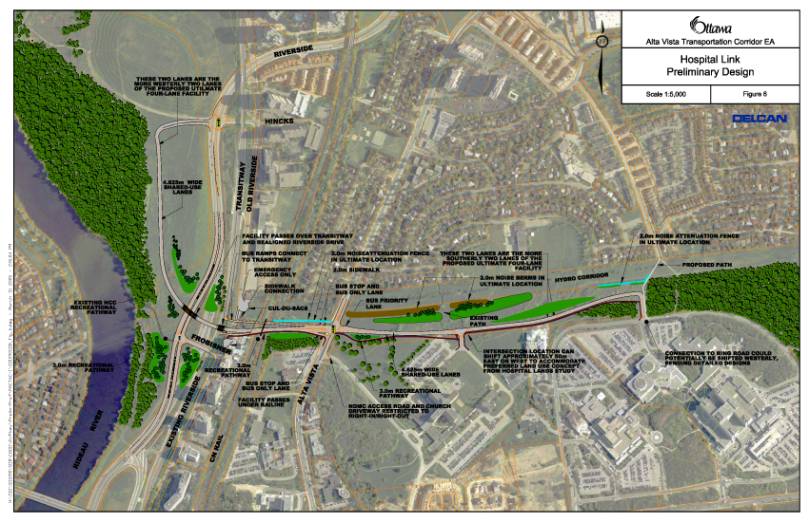
Document 6 is a plan of the Hospital Link Road. Through various past motions approved by Committee and Council, it is this facility that the City intends to build in the near future and represents the primary recommendation of this study although the EA examined the entire corridor from Nicholas to Walkley/Conroy to avoid piecemealling the analysis. The facility generally consists of a two lane roadway extending from the Hincks Lane/Riverside Drive intersection, through the NCC property adjacent to the Rideau River, crosses over Riverside Drive, over the Transitway (with ramps to the Transitway for bus access), under the railway then at grade with Alta Vista Drive. Continuing east, the facility follows a meandering alignment in a parkway-like setting to the Hospital Ring Road, with intersections at the future NDMC development and the Hospitals.
Throughout the study, there was extensive consultation and the following are questions that were typically posed about the Hospital Link Road:
The structure over Riverside is necessary for two reasons: safety and functionality. With an at-grade intersection, the westbound approach would have insufficient sight lines making it unsafe for drivers as they will not have adequate time to properly judge stopping sight distance (for vehicles, pedestrians, cyclists). Additionally, with the redistribution of trips, the analysis indicated that the at-grade intersection would fail the day that it opened. The heavy volume of traffic on Riverside Drive, conflicting with the left turn movement coming from the Hospital Link Road would result in excessive delay, and congestion.
Was an at-grade crossing
with the rail line considered?
This possibility was explored given the City’s recent experience with the Woodroffe Avenue/Transitway crossing of the VIA Rail line. This corridor is has long been protected for high-speed rail. While the opportunity exists to explore this further during the design phases of this project, at the planning stage, it is prudent to anticipate the requirement for grade separation in order to assess the greatest possible impacts.
The plan proposes ramps to the Transitway and transit priority signals at Alta Vista Drive. This combination will significantly enhance the delivery of routes 16 and 85 as they will have direct access between the Hospitals and the Transitway, reducing the current circuitous nature of the routes. It also provides residents of Riverview Park with centrally located bus stops and fast access to the Transitway.
The Riverview Park community has concerns about the at-grade
intersection with Alta Vista Drive, as this will allow traffic to pass through
the community. Why is this not grade
separated?
The primary reasons are due to the underground utilities and storm water drains, which would have to be re-routed to accommodate an underpass. As well, preliminary design work indicates that there are technical issues such as sensitive clays, which would make the underpass construction difficult. An overpass would be visually intrusive on the surrounding homes. The additional cost and incompatibility of an interchange in a sub-urban environment suggests that an at-grade solution is the most appropriate. While the intersection will be at grade, potential unwanted community cut-through traffic can be dealt with by implementing turning restrictions. From an operational perspective, the at grade intersection does function appropriately and there was, therefore, no technical need for a grade separation.
Is the circuitous route for
the connection to Riverside Drive necessary?
The study
team realized that the wrap around from the AVTC to the Riverside Drive/Hincks
Lane intersection appears to be a convoluted and larger than necessary
link. As a result, the study team contracted
the transportation engineering consulting firm of National Capital Engineering
to conduct a peer review. This peer
review and subsequent technical analysis of the grade separations, soil
conditions, future constructability and transportation capacity/connectivity
yielded the same results as proposed by the EA study team.
Why
wasn’t the Hospital Link Road extended a short distance further to Smyth Road
thereby redirecting the traffic coming from the southeast (Hawthorne, Russell
Road, etc) away from the Smyth Road/Alta Vista Drive intersection?
This was
the intention of the 2000 Alta Vista Drive/Smyth Road Transportation Strategy,
however, subsequent Council decisions have precluded this possibility. The recent Corporate Services Committee
decisions regarding the lease of 599 Smyth Road to the Ottawa General Hospital
developed an arrangement where this part of the corridor would be used for
temporary parking for a minimum of 10 years.
Future Construction of the Remaining Portions of the Corridor
The previous section describes the Hospital Link Road that is needed in the near future to accommodate the Hospital site expansions. However, the City and in particular the southeast sector, has a longer-term requirement for the Alta Vista Transportation Corridor. The City’s OP and TMP include this facility in its list of required infrastructure to accommodate the anticipated growth in areas such as Riverside South and Leitrim.
By 2021, it is estimated that the City will grow to approximately 1.2 million people (+50%). Through the Ottawa 20/20 plan and the integral smart growth policies of the Official Plan, a transportation network was developed. A transit policy of 30% overall modal peak hour modal split was adopted which significantly reduced the requirement for roadway infrastructure. Despite this reduction, and other transportation demand management policies and initiatives, all of the AVTC segments will be needed eventually if the City grows in the manner that is assumed in the OP.
A significant amount of research was conducted to try and develop a rapid transit facility in the corridor. A report examining the southeast sector revealed that, in fact, a more effective way to serve the demands and achieve the modal split targets is to extend the existing O-Train further south. The City’s Rapid Transit Expansion Study, the TMP and the OP supported this conclusion. It was demonstrated that rapid transit in this corridor is inappropriate given its ineffective ability to attract riders due to the adjacent low-density development, and its inability to accommodate the future vehicular demand.
However, the remaining alternative solutions to the problem continued to include transit enhancements and priority. The evaluation exercise concluded that a 2 lane regular traffic + 2 lane high occupancy vehicle/bus lane was the most appropriate facility to carry forward to the design stage.
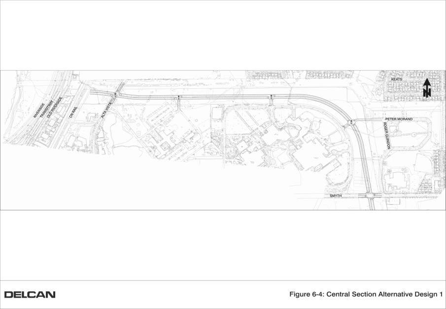
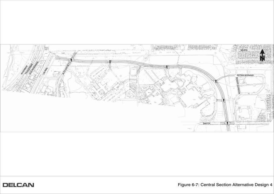
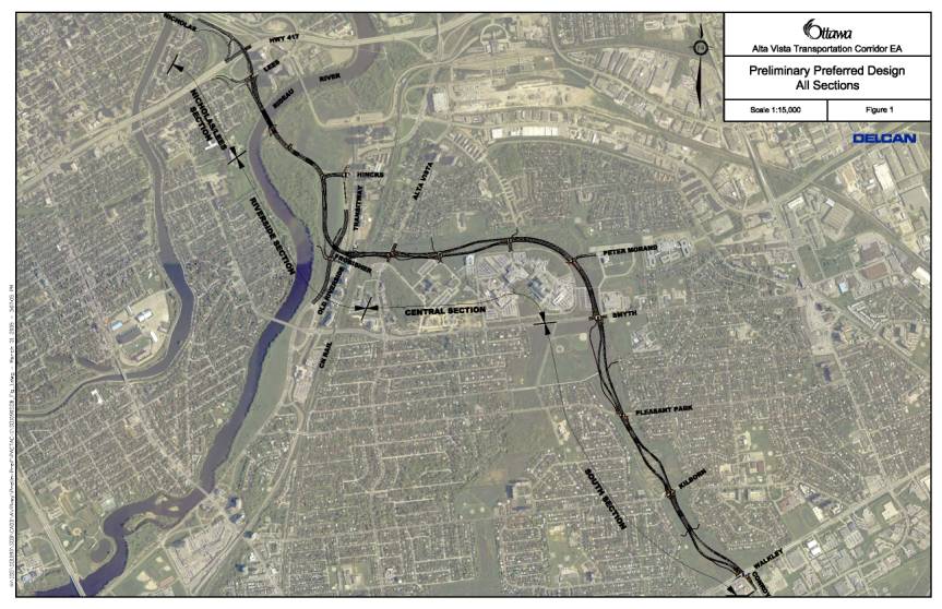
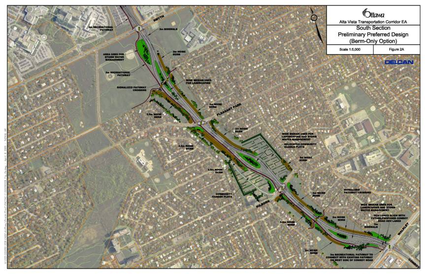
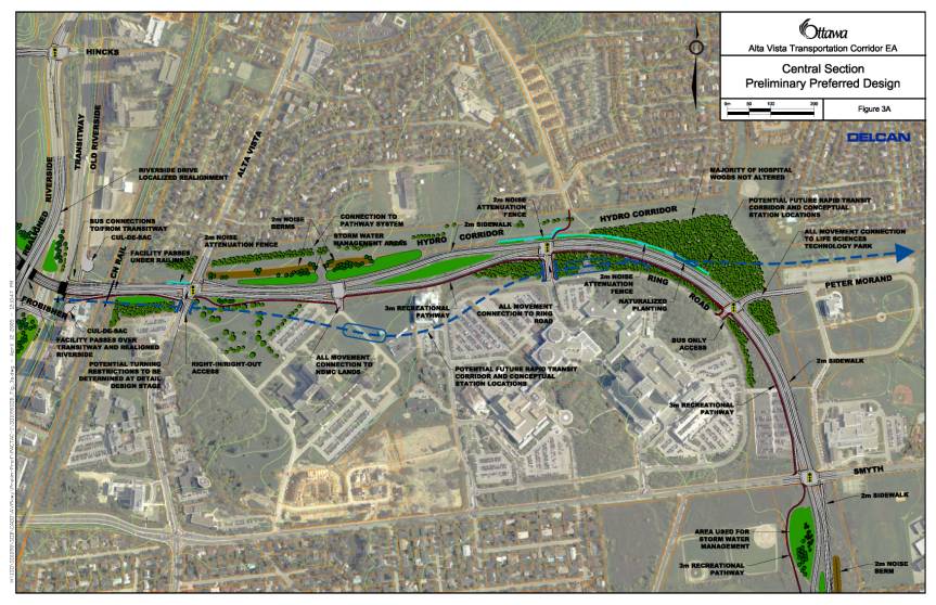
The final recommended plan is shown in Document 1. The following is a summary of the various features of the plan:
South and Central Sections
(Document 2 and 3):
This configuration maintains the majority of the garden plots currently in the corridor and given the width mentioned above, there is opportunity to relocate those affected into adjacent areas of the corridor. As well, given the overall width of the corridor, and that the actual roadway requirements are only about 20% of the space, there is amply opportunity to enhance the landscaping and mitigation measures such as berms.
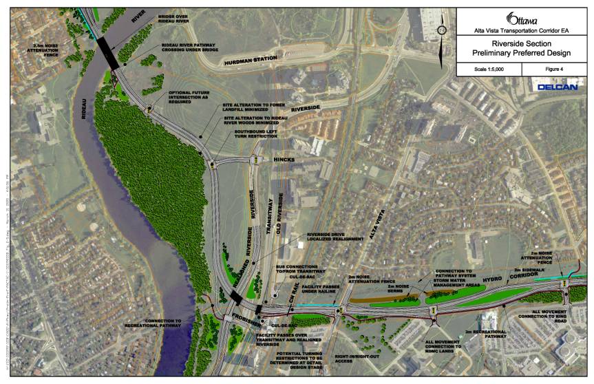
Riverside
Drive, Transitway, Rail Line (Document 4):
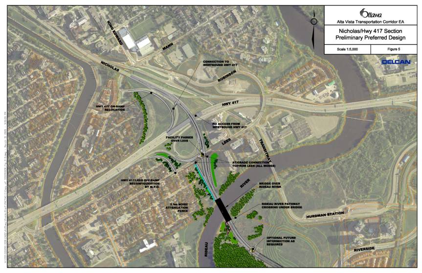
Nicholas Interchange (Document 5):
Although justification and need for the AVTC was exhaustively investigated (described further in this report), the results of this EA are not unanimously supported by all those who participated. Some questions continue to be raised regarding the need for the remaining sections of the facility, if not the entire facility (including the Hospital Link Road itself). However, if the AVTC were not built to meet the demands of the growing City, then the following roads would likely have to be widened to accommodate projected growth in traffic:
If the AVTC and these alternative roads were not built/widened, and development continues as anticipated, then the consequence would be serious congestion on most north-south arterials leading from the southeast sector – resulting in overall loss of productivity, waste of non-renewable resources due to delays, and increased degradation of air quality. The corollary would be to restrict development of Riverside South and Leitrim to approximately 50%, which would have a serious impact on the ridership potential for the North-South LRT Corridor.
Financial Implications:
On 7 February 2005, when Council approved the 2005 budget, $5 Million was allocated to the design of the 1st phase of the AVTC as described in the sections above. The design assignment will be managed from Public Works and Services and will go through the City’s consultant selection process following the City’s purchasing by-law.
Future work in this corridor will be presented to Committee and Council in future budgets.
Public Consultation/Input:
The following is a list of the public consultation events held over the course of this study. Over 2500 people attended these events and numerous communications were received via letters, e-mails, and phone calls. Members of the public provided input to the study through submitting comment-questionnaires from the open houses, partaking in question/answer sessions at the public meetings and through general inquiries to the project team. In addition to the formal events, the entire public consultation plan, including all of the material presented at the events, was posted on the City’s project website (http://ottawa.ca/public_consult/alta_vista/index_en.shtml).
RÉSUMÉ
Hypothèses et analyse :
L’évaluation
environnementale (ÉE) du couloir de circulation d’Alta Vista (CCAV) a été
lancée en 2001 par suite des besoins croissants prévus en transport suscités
par le développement des hôpitaux et du noyau de services de soins de santé,
ainsi que par la croissance approuvée dans le secteur sud-est de la ville. Bien
que le tronçon prioritaire soit l’accès aux terrains de l’hôpital, toute
solution en matière de transport doit s’inscrire dans le contexte plus vaste
d’une solution globale pour le couloir. Ainsi, on a veillé à ce que l’ÉE prenne
en compte les options et leurs effets entre Nicholas/autoroute 417 et
Walkley/Conroy, même si les travaux de construction du projet peuvent être
réalisés par étapes.
Le calendrier de
construction du CCAV dépend du taux de croissance dans le secteur sud-est et
des priorités établies par le Conseil. Toutefois, le tronçon devant être
construit en priorité est compris entre Riverside Sud et le Complexe de santé –
un segment communément appelé tronçon vers l'hôpital. Le Plan directeur des
transports (PDT) désigne cette voie comme nécessaire d’ici à 2008.
En 2000,
l’ancienne Région d’Ottawa-Carleton a réalisé une étude en vue d’examiner
l’ampleur de la croissance potentielle en demande de transport vers les
terrains de l’hôpital et son incidence sur la communauté. On a prévu que la
croissance supplémentaire de l’Hôpital général d’Ottawa et du CHEO générerait
des niveaux de circulation de 50 pour cent supérieurs à ceux
d’aujourd’hui. Bien que des améliorations locales et plus modestes puissent satisfaire
aux besoins à court terme, un projet à plus grande échelle est nécessaire pour
effectuer l’ensemble des travaux et ainsi éviter les embouteillages trop
importants dans les quartiers adjacents.
Le Document 6 est
un plan du tronçon vers l’hôpital. Comme suite à diverses motions déjà
approuvées par le Comité et le Conseil, c’est cette installation que la Ville
souhaite construire dans un avenir proche et qui représente la principale
recommandation de cette étude, même si l’ÉE a examiné tout le couloir entre
Nicholas et Walkley/Conroy afin d’éviter de fragmenter l’analyse. En gros,
l’installation serait une route à deux voies allant de l’angle de l’allée
Hincks/promenade Riverside jusqu’à la propriété de la CCN adjacente à la
rivière Rideau, traversant la promenade Riverside puis le Transitway (avec des
bretelles menant au Transitway pour les autobus), passant sous la voie ferrée
avant de revenir à la hauteur de la promenade Alta Vista. En continuant vers
l’est, l’installation suit un tracé sinueux à la manière d’une voie-promenade
jusqu’à la rocade de l’hôpital, avec des intersections au futur aménagement du
CMDN et aux hôpitaux.
Tout au long de
l’étude, des consultations détaillées ont été menées et ont permis de soulever
les questions suivantes concernant la route de raccordement vers
l’hôpital :
La structure
surplombant la promenade Riverside est nécessaire pour deux raisons :
sécurité et fonctionnalité. Avec un carrefour à niveau, l’approche en direction
ouest offrirait des lignes de visibilité insuffisantes, ce qui serait dangereux
pour les automobilistes car ils ne disposeraient pas d’assez de temps pour
juger adéquatement leur distance de freinage (pour les autres véhicules, les
piétons et les cyclistes). De plus, avec la réorganisation des déplacements,
l’analyse a indiqué qu’un carrefour à niveau créerait des difficultés dès la
première journée. La densité de la circulation sur la promenade Riverside,
associée aux véhicules venant de la route de raccordement vers l’hôpital et
tournant à gauche, entraînerait de longs retards et des embouteillages.
Un carrefour à niveau avec la voie ferrée a-t-il
été envisagé?
Cette possibilité
a été étudiée en raison de l’expérience récente de la Ville à l’angle de
l’avenue Woodroffe/Transitway et de la voie ferrée de VIA Rail. Ce couloir est
depuis longtemps protégé pour les voies ferrées rapides. Bien qu’il soit
possible d’explorer plus à fond cette possibilité lors des étapes de conception
de ce projet, il est prudent, à l’étape de la planification, de prévoir la
nécessité de changement de niveau afin de connaître le plus grand nombre
possible de répercussions.
Le plan propose
l’aménagement de bretelles vers le Transitway et des panneaux de signalisation
de priorité aux autobus à la hauteur d’Alta Vista. Ces mesures amélioreront
considérablement la circulation des circuits 16 et 85 puisqu’ils auront un
accès direct entre les hôpitaux et le Transitway, rendant ainsi les trajets
moins tortueux. Elles procureront également aux résidents de Riverview Park des
arrêts d’autobus centralisés et un accès rapide au Transitway.
La communauté de Riverview Park s’inquiète du carrefour
à niveau à la hauteur de la promenade Alta Vista car il permettra à la
circulation de traverser le quartier. Pourquoi ce carrefour n’est-il pas étagé?
Les principaux
motifs de ce choix sont liés aux services publics souterrains et aux drains
d’eaux pluviales, qui devraient être déplacés pour permettre la construction
d’un passage inférieur. De plus, les travaux de conception préliminaire ont
révélé des problèmes techniques, tels que de l’argile sensible, qui
compliqueraient la construction d’un passage inférieur. Un viaduc créerait un
obstacle visuel pour les résidences des alentours. Vu les coûts supplémentaires
à engager et l’incompatibilité d’un échangeur dans un environnement suburbain,
la solution d’un carrefour à niveau s’avère la plus appropriée. Malgré un
carrefour à niveau, la circulation de transit non souhaitée dans la communauté
pourra être évitée par la mise en place de restrictions de virage. D’un
point de vue opérationnel, un carrefour à niveau fonctionne adéquatement et
aucune nécessité technique n’a par conséquent été relevée en faveur d’un
carrefour étagé.
Le trajet tortueux menant à la promenade Riverside
est-il nécessaire?
L’équipe chargée de l’étude
s’est aperçue que le contournement entre le CCAV et l’angle de la promenade Riverside
et de l’allée Hincks semblait être tortueux et plus large que nécessaire.
L’équipe de l’étude a donc chargé l’entreprise de consultation en génie de
transport National Capital Engineering de mener une révision par les pairs.
Cette révision et l’analyse technique qui en a découlé concernant un carrefour
étagé, les conditions du sol, la constructibilité et la capacité/connectivité
en matière de transport ont donné les mêmes résultats que ceux proposés par
l’équipe chargée de l’étude d’ÉE.
Pourquoi le tronçon
vers l'hôpital n’a-t-il pas été légèrement prolongé vers le chemin Smyth de
manière à diriger la circulation venant du sud-est (Hawthorne, chemin Russell,
etc.) ailleurs que vers l’angle du chemin Smyth et de la promenade Alta Vista?
Telle était l’intention
manifestée dans la Stratégie de transport routier sur l’angle promenade Alta
Vista/chemin Smyth élaborée en 2000. Toutefois, des décisions subséquentes du
Conseil ont écarté cette possibilité. Les décisions récentes du Comité des
services organisationnels concernant la location du 599, chemin Smyth à
l’Hôpital général d’Ottawa font état d’une entente par laquelle cette partie du
couloir servirait de parc de stationnement temporaire pour une période minimale
de dix ans.
Construction
future des parties restantes du couloir
La section
précédente décrit le tronçon vers l’hôpital qui doit être construit dans un
proche avenir en vue de l’agrandissement du site. Toutefois, la Ville, plus
particulièrement dans le secteur sud-est, exige depuis longtemps le couloir de
circulation d’Alta Vista. Le PO et le PDT de la Ville mentionnent cette
installation dans leur liste d’infrastructure requise pour faire face à la
croissance prévue dans des secteurs tels que Riverside Sud et Leitrim.
D’ici à 2021, on
estime que la Ville aura une population d’environ 1,2 million d’habitants
(+50 %). Lors de l’élaboration du plan Ottawa 20/20 et des politiques
intégrales de croissance intelligente du Plan officiel, un réseau de transport
a été constitué. Une politique de transport en commun équivalant à 30 % de
la répartition modale d’ensemble en heure de pointe a été adoptée et réduit
sensiblement la nécessité d’une infrastructure routière. Malgré cette réduction
et d’autres politiques et initiatives de gestion des besoins en transport, tous
les tronçons du CCAV seront un jour nécessaires si la ville s’agrandit autant
que le prévoit le PO.
De nombreuses
recherches ont été réalisées pour tenter d’élaborer une installation de
transport en commun rapide dans le couloir. Un rapport sur le secteur sud-est a
révélé que, en réalité, la manière la plus efficace de répondre aux besoins et
d’atteindre les objectifs de répartition modale consiste à prolonger vers le
sud la ligne d’O-Train existante. L’Étude sur l'expansion du réseau de
transport en commun rapide de la Ville, le PDT et le PO appuient cette
conclusion. Il a été démontré que le transport en commun rapide dans ce couloir
s’avérait inapproprié en raison de la faible densité du lotissement adjacent et
de son incapacité à s’adapter aux besoins futurs en automobiles.
Toutefois, les
solutions de rechange restantes à ce problème accordent la priorité au
transport en commun et proposent d’y apporter des améliorations. Cet exercice
d’évaluation a permis de conclure qu’une chaussée à deux voies normales plus
deux voies pour véhicules à plusieurs occupants/autobus constituait la solution
la plus appropriée pour réaliser l’étape de conception.
Le plan final
recommandé figure dans le Document 1. Voici un résumé des diverses caractéristiques
de ce plan :
Tronçons
sud et central (Document 2 et 3) :
Cette
configuration préserve la majorité des potagers actuels du couloir et, vu la
largeur disponible mentionnée plus haut, il pourrait être possible de
réaménager dans des zones adjacentes du couloir ceux touchés par le projet. De
même, étant donné la largeur globale du couloir, et puisque les besoins réels
pour la chaussée ne sont que d’environ 20 % de l’espace disponible, il
existe de nombreuses possibilités d’améliorer l’aménagement paysager et
d’installer des talus comme mesure d’atténuation.
Promenade Riverside,
Transitway, voie ferrée (Document 4) :
Échangeur de la rue
Nicholas (Document 5) :
Bien que la
nécessité du CCAV ait été étudiée en détail (voir plus loin dans le présent
rapport), les résultats de l’ÉE ne sont pas entérinés à l’unanimité par les
intervenant y ayant participé. Certaines questions continuent d’être soulevées
quant à la pertinence des tronçons restants de l’installation, sinon de toute
l’installation (y compris le tronçon vers l’hôpital). Toutefois, si le CCAV
n’était pas construit pour répondre aux besoins croissants de la ville, les
voies suivantes devraient sans doute être élargies pour faire face à
l’augmentation prévue de la circulation :
Si le CCAV n’est
pas construit et ces autres voies ne sont pas élargies, et si la croissance se
poursuit comme prévu, il en résultera de graves problèmes de circulation sur la
plupart des artères nord-sud venant du secteur sud-est – avec pour conséquence
une perte globale de productivité, une perte de ressources non-renouvelables en
raison des retards et une dégradation accrue de la qualité de l’air. Le
corollaire serait de limiter le développement de Riverside Sud et de Leitrim
d’environ 50 %, ce qui aurait des répercussions sérieuses sur le potentiel
d’usagers du couloir de train léger nord-sud.
Répercussions financières :
Le 7 février
2005, lorsque le Conseil a approuvé le budget de 2005, une somme de 5 millions
de dollars a été affectée pour la conception de la première étape du CCAV, tel
que décrit dans les sections ci-dessus. Les travaux de conception seront
administrés par Services et Travaux publics et soumis au processus de sélection
de consultant de la Ville, conformément au règlement municipal sur les marchés.
Les prochains
travaux prévus dans ce couloir seront présentés au Comité et au Conseil dans
les prochains budgets.
Consultation publique / commentaires :
Vous trouverez
ci-après une liste des événements de consultation du public qui ont eu lieu
tout au long de cette étude. Plus de 2 500 personnes ont participé à ces
événements et de nombreuses communications ont été reçues par courrier,
courriel et téléphone. Les membres du public ont fait part de leurs
commentaires sur l’étude en remplissant les fiches fournies lors des réunions
portes ouvertes, en prenant part aux séances de questions/réponses des réunions
publiques et en posant des questions d’ordre général aux membres de l’équipe
chargée du projet. En plus des événements officiels, l’intégralité du plan de
consultation du public, y compris tous les documents présentés lors des
événements, a été affiché sur le site Web de la Ville consacré au projet
(http://ottawa.ca/public_consult/alta_vista/index_en.shtml).
BACKGROUND
The City of Ottawa initiated the Alta Vista Transportation Corridor Study in 2000 in response to concerns about the potential traffic and transportation system deficiency to/from the CHEO and Ottawa General Hospital Campus. A 2000 study conducted by the former Region of Ottawa-Carleton examined the level of growth of these health care facilities in the Alta Vista area and developed several recommendations to address the anticipated transportation capacity deficiency. While there were short-term improvements recommended, the ultimate solution is the construction of the Alta Vista Transportation Corridor (AVTC). This facility would not only serve the expansion of the Hospital Lands area, but also serve the growing communities of Riverside South and Leitrim. These communities were approved for development based on a number of goals and assumptions, one of which is the future construction of the AVTC to serve these areas. The AVTC is included in the current Official Plan (OP) as well as past versions of the OP since the 1960s.
The recommendation of the 2000
transportation study read:
To ensure the timely delivery of the
section of the Alta Vista Parkway (note: name subsequently changed
to Transportation Corridor) between Smyth
Road and Riverside Drive (with links to the Hospital Ring Road), and the ramps
to the Southeast Transitway, appropriate funds need to be identified in the
five year Budget of the new City of Ottawa to complete the Environmental
Assessment Study of the Alta Vista Parkway between Conroy road and the
Queensway.
As such, the AVTC EA was initiated. Regional council approved this action with
some conditions, namely:
That Recommendation 7 (to initiate the
AVTC EA) of the Delcan study be amended to ensure that when doing the
Environmental Assessment, the Alta Vista Parkway (transportation corridor) be
studied as a 'bus/light rail only' route and as a 'transit/vehicles' route.
City Council directed staff to initiate the AVTC EA through consultation with
interested public participants.
Consultation meetings were held and a Statement of Work was developed.
The Statement of Work scoped the tasks of the EA and was subsequently approved
by Transportation Committee in 2001.
The Statement of Work was broken into three sections, all of which were to be
presented to Transportation Committee at various stages in the study.
Status Update #1 (20 November 2002):
The first update was presented to Transportation Committee on 20 November 2002
and detailed the results of: the draft Existing Conditions Report, the Needs
Assessment Report, the Identification of Alternative Solutions Inside and
Outside the Corridor; the Identification of the Evaluation Process and
Criteria, and Public Open House #1. Although the study was still in the
exploratory stage of the EA process, Committee put forward a motion that, in
essence, preset the implementation phasing of the facility:
1. Therefore, be it resolved that once
the Alta Vista Transportation Corridor Environmental Assessment is completed
and approved, that the General Manager of Development Services be directed to
present to the
Transportation and Transit Committee for implementation, only those sections of
the Environmental Assessment that provide transportation solutions for the
Ottawa Hospital Complex; and Further be it resolved that the General Manager of
Development Services be directed to include in the 10 year
Capital Budget (2003-2013) only funding for transportation solutions for the
Ottawa Hospital Complex.
A second motion was also approved at Committee:
2. Be it resolved that the second stage of the Environmental Assessment, the
Alta Vista Transportation Corridor Environmental Assessment Team investigate
the possibility of estimating air quality costs to human health of the various
options and that the weighting of this criteria be made available to the public
with the rest of the criteria weighting; and Be it further resolved that if the
costs associated with this investigation cannot be absorbed within the current
study budget, staff will report back to the Transportation and Transit
Committee.
Status Update #2 (19 May
2004):
The second update was presented to Transportation Committee on 19 May 2004. The
presentation reported to committee the study activities between the previous
update up to and including the results of the second open house. The study
tasks included: Updating the Needs Assessment based on the City's new TMP
(2003) and Official Plan (2003), carrying out the Criteria Weighting Exercise,
undertaking an Evaluation of Transit Alternatives for the City's Southeast
Sector, identifying Alternative Solutions Inside and Outside the Corridor,
undertaking the Evaluation Exercise to determine the technically preferred
alternative, hosting Public Open House #2.
With regards to Committee’s direction to investigate transit solutions for the AVTC, a report titled Evaluation of Transit Alternatives was prepared and reviewed by the study’s various consultation groups. This exercise determined that a rapid transit-only facility in the corridor was not a practical alternative and a recommendation to screen out this alternative was proposed. The study determined that the most appropriate solution as being a facility comprising of 2 regular lanes and 2 high-occupancy vehicle/bus-only lanes (HOV/BOL).
Committee concluded the second study update with the following motion:
Whereas on September 13, 2000, RMOC Council directed Staff “to
ensure that when doing the Environmental Assessment, the Alta Vista Parkway be
studied as a "bus/light rail only" route and as a
"transit/vehicles" route;”
Whereas the Hospitals area is a key connection in the City’s rapid
transit network;
Whereas during the February 2003 RTES debate Council directed that
“given the concerns of the Riverview Park Community Association and area
residents…staff review corridor options other than the Browning Avenue
corridor;”
Whereas
there is an ongoing OMB challenge of the Browning Ave. corridor portion of the
City’s rapid transit network in the TMP/OP;
Whereas should the current Browning Ave. corridor portion of the TMP
be removed by the OMB, a portion of the AVTC could be used to replace the
required rapid transit connection from the Hospitals area to the Innes east-end
hub;
Whereas the September 2000 RMOC Council-approved Alta Vista
Drive/Smyth Road Transportation Strategy recommended that “…further study
should be undertaken to determine the feasibility of a centrally located
transit-only spine road running east-west through the middle of the campus;”
Whereas the March 2003 AVTC EA Study document Evaluation of Transit
Alternatives ruled out any further evaluation and comparison of transit-only as
an alternative within the Alta Vista corridor;
Whereas the ongoing MTO 417 EA’s preliminary recommendation is for
no widenings of the Queensway in the core between Metcalfe and Island Park
Drive, meaning a maximum of less than one kilometre of new through-lane
capacity from Nicholas to Metcalfe to absorb the estimated 70% of westbound
drivers from a future AVTC/Queensway interchange;
Be it resolved that staff be directed to complete the comparisons of
the AVTC as a bus-only route and transit/vehicles route, as directed by Council
in September 2000.
The analysis completed and results of all of the above Transportation Committee
directions are documented in the DISCUSSION
following sections of this report.
On
13 July 2005, Council considered the motions from the Corporate Services and
Economic Development Committee meeting of 21 June 2005 and approved the
following:
Whereas the
Ontario Environmental Assessment Act requires the City to conduct a full
environmental assessment of the Alta Vista Corridor not withstanding that the
City only plans to develop and construct one portion;
Whereas the
City of Ottawa’s Official Plan is subject to a five year review and whereas the
Alta Vista Corridor Official
Plan designation will be eligible for review in the 5-year Official Plan
review;
Whereas there
is no prospect for the development and construction of a four lane roadway in
the corridor in the foreseeable future;
Therefore be it
resolved that Corporate
Services and Economic Development Committee recommend:
1. That
Council approve that the City enter into a lease with The Ottawa Hospital
(General Campus) for a part of the Alta Vista Corridor adjacent to the hospital
(as set out in the staff report ACS2005-CRS-RPR-0025)
for a period of 15 years with an option to renew for an additional 5 years, in
order to enable the hospital to increase their revenues over the next 15 to 20
years to assist in reaching their capital funding requirements, as amended by the
following:
That
Ottawa City Council waive the requirement for the payment of rent as set out in
report ACS2005-CRS-RPR-0025 (Lease of Land – 599 Smyth Road, Ottawa);
And
that, in lieu of such rent, The Ottawa Hospital deposit the said sum into an interest
bearing account and such money shall be used by The Ottawa Hospital for the
sole purpose of construction by The Ottawa Hospital of a parking structure on
The Ottawa Hospital’s property at 501 Smyth Road, Ottawa, within the term of
the Land Lease for
599 Smyth Road, Ottawa;
And
that, The Ottawa Hospital provide the City of Ottawa with annual audited
financial statements regarding the reserve account no later than three (3)
months after the end of each fiscal year of The Ottawa Hospital;
And
that, should
The
Ottawa Hospital not
proceed with construction of the parking structure within the lease term, The
Ottawa Hospital shall pay to the City of Ottawa, all rents payable in
accordance with report ACS-CRS-RPR-0025, plus accrued interest;
And
that the
lease include a termination clause at year 8 with a 24 month notice period,
consistent with the negotiations underway between the City and The Ottawa
Hospital; and
2.
That
Council approve that staff be directed, pursuant to the City’s Major and Minor
Community
Partnership Capital Grant Programs, to solicit community based proposals to
develop, on the basis of a 15-year lease, with an option to renew for 5 years,
green space or recreational uses of a non-permanent type for the Alta Vista
Corridor lands in or
around Kilborn and for corridor lands south of Lees Avenue; and
3. That
Council approve that any budget or Long Term Financial Plan designation for
funding for development and construction within the Alta Vista Corridor between
Riverside Drive and Conroy Road,
be deleted except for those funds allocated or designated for the development
and construction of the road and/or transit link from Riverside Drive to the
hospital complex, and that the requirement for notice under the Notice By-law
(By-law 2002-522)
be waived; and
4. That
Transportation Committee recommend to Council that for any corridor
transportation or transit uses contemplated by the current environmental
assessment and report process, Council shall approve only that portion
designated from Riverside
Drive into the hospital complex.
Approved amendments to this motion were as follows:
Be
it resolved that
non-permanent use of green space within the Alta Vista Transportation Corridor
be restricted to areas where there is sufficient land available so
that temporary uses do not interfere with the preferred alignment for the Alta
Vista Transportation Corridor;
And
be it further resolved that
the City erect signs indicating that any use of the green space within Alta
Vista Transportation Corridor is
temporary, and :
3. That
Council approve that any budget or Long Term Financial Plan designation for
funding for development and construction within the Alta Vista Corridor between
Riverside Drive and Nicholas/417, be deleted except for those funds allocated
or designated for the development and construction of the road and/or transit
link from Riverside Drive to the hospital complex, and that the requirement for
notice under the Notice By-law (By-law 2002-522) be waived; and
DISCUSSION
The Alta Vista Transportation Corridor EA has proven to be a difficult exercise in balancing diverse opinions expressed by the communities affected. Over the course of the last four years, significant work and consultation have taken place to bring the project to this final stage. This section of the staff report is a detailed summary of all of the project tasks/major topics. The following is a list of the tasks/major topics of the project:
1. Needs Assessment
2. Development of Alternative Solutions
3. Evaluation of Rapid Transit
4. Evaluation Process
5. Evaluation Methodology
6. Re-Evaluation Process
7. Development of Alternative Designs and Evaluation
8. Technically Recommended Plan
9. Hospital Link Road
The
technical analysis supporting the City’s Official Plan (OP), Transportation
Master Plan (TMP) and that analysis conducted throughout this study, concludes
that the AVTC is needed. Approvals for
growth and development of communities such as Riverside South and Leitrim were
based on the assumption that the transportation facilities (rapid transit and
roads) identified in the OP and TMP would be in place – including the AVTC.
The TMP
identifies when various sections of the corridor are required to be
implemented. In the short term,
capacity is required to facilitate the development of the Health Care Node
along Smyth Road. In the longer term, a
connection to the Queensway and south to Walkley Road both provide important
links needed to maintain what is considered and documented in City policies to
be acceptable levels of service.
As
background to these recommendations, the Needs Assessment report (March 2002,
and subsequent updates) represents part of the first phase in the Environmental
Assessment Study for the AVTC. The
Corridor has been identified for transportation purposes since 1966 and this
was reconfirmed in the 2003 City of Ottawa’s OP and TMP. A key component of the analysis was to
re-evaluate if there is a need to provide for transportation infrastructure in
the study area to help meet the current and future transportation-related
requirements in the Southeast Sector of the City.
The
analysis considered:
· Existing travel conditions at specific screenlines within the Southeast Sector
· Various travel modes across these screenlines
· Growth areas in the Southeast Sector
· Future travel conditions related to the City's new population growth targets to the year 2021
· Future vehicular capacities of the screenlines
· Future capacity surpluses or deficiencies across the screenlines
· A broad range of possible future strategies to address deficiencies in screenline capacity
·
A more
localized view of existing and future road and intersection capacity in the
Alta Vista/Smyth area related to planned growth at the Smyth Road Hospital
Complex, the Train Yard Lands and NCC lands located north of Hurdman Station.
The conclusion of the Needs Assessment document was threefold. Firstly, with regard to the Southeast Sector as a whole:
“This
analysis demonstrates that the current levels of service/congestion are
approaching critical levels. The projected
year 2021 conditions indicates that even with the implementation of a broad
range of travel reducing strategies, with the achievement of higher transit
modal share targets and with increased overall road system efficiency, there is
still the need for a considerable amount of additional transportation
infrastructure throughout the Southeast Sector.”
Secondly, with regard to the Walkley and Smyth Screenlines, which include the AVTC corridor:
“Specific
analysis of future transportation needs north of Walkley Road indicated the
need for additional transportation capacity/infrastructure across the Walkley
and Smyth Screenlines to address the transportation needs of the Southeast
Sector by the Official Plan horizon (2021), and that this infrastructure is
only part of a larger package of transportation-related solutions for this
sector. The alternatives to address the
projected deficiency both inside and outside the AVTC range from a transit-only
solution, to various transit/road combinations to road-only solutions.”
Thirdly, with regard to the more localized needs on the vicinity of the Smyth Road Hospital Complex:
“There is an imminent and identified need for additional transportation system capacity in the section of the AVTC from Smyth Road to Riverside Drive, regardless of the outcome of the environmental assessment for the AVTC as a whole. For example, should the EA conclude that the appropriate solution for the AVTC as a whole is the “do nothing” alternative, there remains a previous and current demonstrated need to provide additional road capacity and transit service in the section of the AVTC from Riverside Drive east to Smyth Road.”
· attainment of a 30% transit share of overall travel in the afternoon peak (the new OP’s target) will result in the projected transit modal split at individual screenlines in the Southeast Sector being within the range of 50% to 32%, from north to south. This compares to the 40% to 15% range of target transit shares that were established in the 1997 Regional Official Plan.
· Even with the attainment of the above-noted increased transit modal splits at individual study area screenlines, a considerable amount of residual travel demand remains that will require additional roadway capacity within the Southeast Sector.
· Specifically, the additional arterial road infrastructure identified as necessary by 2021 in the Southeast Sector includes the widening of each of: River Road/Limebank Road, Albion Road and Bank Street across the Leitrim Screenline, the widening of Conroy Road to six lanes, the twinning of the Airport Parkway across the CNR East Screenline, and the provision of additional arterial capacity north of Heron/Walkley through the study area sufficient to accommodate 1800 vph in the peak direction.
· There is a significant projected capacity deficiency across the Rideau River Central Screenline that could be partially alleviated by additional road capacity linking the Southeast Sector across the Rideau River to the Queensway and beyond.
2. Development of Alternative Solutions
The alternative solutions to address the future
transportation needs of the Southeast Sector of Ottawa, and specifically the
projected capacity deficiencies across the Walkley/Heron and Smyth Road
Screenlines included a full range of alternatives both within and outside of
the AVTC. These are briefly described
as follows:
(a) Within the AVTC Corridor
·
Rapid Transit
Only: This solution took the form
of either laying tracks in the corridor for a rail-based technology or building
a two-lane transitway. Stations were
developed at appropriate locations for walk-in and drop-off of passengers,
park-and-ride, and for vehicle access in the case of a transitway.
Roadway
Only: These solutions provided
capacity for all vehicles (private and transit) by building either a two-lane
or a four-lane roadway from Conroy Road to the Queensway (Nicholas
interchange). The two-lane roadway
option was either for general traffic or High Occupancy Vehicle (HOV) usage
during peak periods. Variations of a
four-lane roadway had two lanes for general traffic and two lanes for HOV usage
either all day or during peak periods only.
·
Hybrid
Solutions: Either of the foregoing
rapid transit solutions could have been combined with a two-lane (or four-lane)
roadway giving a high level of service for both transit and private
vehicles. A four-lane roadway could
also have been developed with two lanes for general traffic and two bus lanes,
thus providing extra capacity for private and public vehicles.
·
Do Nothing: No transportation facilities would be
built in the corridor but with the necessary additional transportation capacity
either provided outside the AVTC or not at all. There are, however, plans for a recreational pathway in the AVTC
that could be implemented independently.
If the corridor were not to be used for transportation purposes, its
future use could be the subject of a detailed land use study to determine the
best use of the land for the achievement of the Smart Growth objectives of the
OP.
(b) Outside the AVTC Corridor
· Rapid Transit Only: There were 3 options for a rapid transit solution outside the Corridor.
The first entailed the extension of the
existing Southeast Transitway and/or the O-Train south of the Hunt Club Road to
the Airport and the Riverside South Leitrim Community.
The second alternative entailed the development of a rail-based technology in the existing abandoned railway corridor extending from the Hurdman/Train Station southeasterly paralleling the Highway 417 corridor to south of Walkley Road and then following the CN/CP Railway/Hydro Corridor westerly to the Southeast Transitway/O-Train corridor.
An alternative to this which is both within and
outside the Corridor is the development of a rail-based-technology extending
from the Hurdman Station south to the AVTC Corridor, then extending east along
the north limit of the Hospital Complex, through the Perley Hospital site and
along the south side of Innes Road to the above-noted Highway 417 corridor to
join with the possible Cumberland Transitway corridor which has not yet been
finalized west of Blackburn Hamlet. (Please note: this was part of the original evaluation ~ section 6.0 of this
report discusses the Re-Evaluation exercise directed by Transportation
Committee).
· Roadway Only: The provision of additional roadway capacity for general traffic could have been achieved outside the AVTC corridor by widening any one or more of the following existing roads north of Walkley Road/Heron Road.
o
Riverside
Drive
o
Bank Street
o
Alta Vista
Drive
o
Russell
Road/St. Laurent Boulevard/Tremblay Road
· Hybrid Solutions: Combinations of both the rapid transit and roadway only solutions outside the corridor could have provided additional capacity for both private and public transit vehicles.
·
Travel Demand
Management: Generating greater results from policies, programs and
implementation strategies that decrease
private automobile travel such as:
o
education
and publicity;
o
legislation
o
employer
initiatives;
o
parking
space maximums;
o
on-road
cycling accommodation; and
o
mixed-use
development.
It
is noteworthy that a TDM effect has already been assumed in the Needs
Assessment.
· Utilization of Transit System Capacity: Enhancement of the existing transit service within the study area and the operation of rapid transit on the Southeast Transitway and O-Train Corridors to maximize both the peak period share of travel by transit and the available capacity in these existing corridors. This is already implied to a considerable extent in the Needs Assessment with the assumptions of a greater share of travel by transit in the projection of future (2021) transportation needs.
3. Evaluation of Rapid Transit
As an early priority in the EA, a study of transit in the Southeast Sector was conducted. The resultant report “Evaluation of Transit Alternatives, March 2003” gave consideration the City’s 2021 OP growth projections and applied the OP’s new transit modal split and Transportation Demand Management (TDM) targets. These being 30% transit city-wide (up from the current 17%) and an approximate TDM travel reduction target of 8%.
The transit study addressed the various combinations of rapid transit and supporting surface buses to best accommodate the Southeast Sector’s projected 2021 travel needs. With regard to north-south rapid transit, both the O-Train/Southeast Transitway Corridor and the Alta Vista Transportation Corridor were evaluated to determine how to best extend rapid transit service to the southern growth areas and how to best maximize transit ridership for the dollars spent. The study concluded that the extension of the O-Train/Southeast Transitway Corridor was by far the best corridor for north-south rapid transit for the Southeast Sector, and that the AVTC should not be recommended for north-south rapid transit in addition to the O-Train Corridor/Southeast Transitway Corridor.
Concurrent with the transit study, the City was conducting the Rapid Transit Expansion Study (RTES) and the TMP as input to the Official Plan. Following extensive study, both the RTES and the TMP recommended the extension of the O-Train Corridor as being the best corridor for north-south rapid transit in the Southeast Sector (along with the Southeast Transitway). The City’s OP incorporated these recommendations.
Consideration was also given to how much the transit ridership would have to increase above the OP’s 2021 targets in order to absorb the projected surplus travel demand of 1800 vph in the peak direction so that there would be no deficiency in the area’s north-south road network across the key study area screenlines (i.e., no road required in the AVTC). It was determined that the percentage of transit across the Walkley-Heron and Smyth Screenlines would have to increase from the current 14% (1,750 transit riders) up to 57% (13,000 transit riders), and from 27% (1,640 transit riders) up to 60% (6,475 transit riders) respectively. The proposed transit system has the capacity to accommodate these increased riders, however, the issue is not one of transit system capacity, but one of how much of a transit modal split and/or increase in transit ridership is a realistic target on which to plan the City. As the study team believes these are unrealistically high levels of transit ridership, it was appropriate to proceed with identifying, assessing and evaluating alternatives to accommodate the aforementioned projected surplus of 1800 vph.
A two-staged evaluation methodology was developed for this study due to the unique situation of having to consider alternative solutions both outside and inside the Corridor. This process was extensive and the primary topic of Status Update #2 staff report. As such, the evaluation methodology has been summarized here. However, Document 7 of this report presents the full explanation of the exercise.
(a) Outside the Corridor Evaluation Process
The alternative solutions outside the corridor were assessed using a screening process to determine their suitability/feasibility as a solution, and also to identify how their potential selection as a solution would affect the form and function of any potential transportation facilities in the AVTC.
(b) Inside the Corridor Evaluation Process
For those alternative solutions inside the corridor, plus those remaining alternatives from outside the corridor screening, the appropriate evaluation method addressed the following:
With the methodology established, the following tasks were carried out:
·
Impact
Analysis
·
Application
of Evaluation Method
·
Selection of
Preliminary Preferred Alternative
2-All-purpose Lanes and 2 HOV/Bus Lanes (Alternative 3) was identified as the preliminary preferred alternative based on the foregoing evaluation and assessment procedure. This alternative, as depicted in Document 1, includes:
The overall ranking of alternatives is as follows:
1st: 2 All-purpose lanes and 2 HOV/Bus-Only-Lanes (Alternative 3)
2nd: 2-lane road (Alternative 2)
3rd : 4-lane road (Alternative 4)
4th : Do-nothing (Alternative 1)
5th : Widen Arterials and Collector (Alternative 6)
6th
: Widen Arterials (Alternative 5)
Sensitivity Analysis
Following the initial identification of the preliminary preferred alternative, a sensitivity analysis was undertaken to determine which of the criteria categories most affected the ranking of alternatives and if the category weighting were changed, how would the rankings change. The following is brief summary of the sensitivity analysis.
In summary, the sensitivity analysis supports the selection of Alternative 3, 2-all-purpose lanes and 2 HOV/bus lanes, as the preliminary preferred alternative.
5. Re-evaluation
of the Alternative Solutions:
The BACKGROUND section of this report documents the Transportation Committee’s direction to re-evaluate the alternative solutions with the addition of a bus rapid transit alternative included. The study team developed the seventh alternative solution, which would be a bus based Transitway running from the Southeast Transitway to the East-West O-Train line south of Walkley Road. The rationale for this alternative stemmed from the possibility that the Hospital Rapid Transit link, which is under appeal, could be removed from the Official Plan. As such, a transit rider, coming from the east, wishing to access the Hospitals would ride the East-West LRT to a station at Conroy, transfer to a BRT facility extending north to and through the Hospitals. The bus would then have the opportunity to connect with the Southeast Transitway.
The entire evaluation process, including this alternative, was undertaken again. A sensitivity analysis was also conducted to ensure consistency with the process and most importantly, provide an understanding of the acceptability of the transit only alternative.
The results of the evaluation
process generated similar results. (Alternative 3) 2-lanes for regular traffic
and 2-lanes for HOV/buses continued to be the preliminary preferred
alternative. The transit alternative
ranked 4th primarily due to its inability to address the future
traffic demands as described previously in section 3.0.
6. Development of Alternative Designs and Evaluation:
A great deal of effort and detail was incorporated in the development of the alternative designs. To ensure Transportation Committee has the benefit of reviewing all aspects of this stage, a full description of the alternatives and evaluation process are attached in Document 8.
In summary, having reconfirmed the technically preferred alternative, the study team developed various design options for the 2+2. The corridor is lengthy and was split into logical segments to narrow the focus on each section and resolve issues specific to them. The four segments examined were the South Section (Conroy to Smyth), Central Section (Smyth to Alta Vista), Riverside Section (Alta Vista to Rideau River), and the Nicholas Interchange. Below is a list of the common design objectives used in all sections. The description of methodology and evaluation process to determine the preferred alternative designs follows.
Given the nature of the Preferred Solution (roadway based), together with the locational influences and the OP policy context for the AVTC, the following are fundamental components and common design objectives of all alternative designs to be evaluated:
Between Walkley Road and Riverside Drive, the facility will be designed as a Scenic Route, as designated in the Official Plan. Opportunities to design the northern portion (between Riverside Drive and Hwy 417) as a Scenic Route will also be pursued as appropriate. As a Scenic Route, the AVTC should contribute to the continuity of the City’s greenspace network and its open space character. The designs should have regard to the following criteria as set out in Section 4.6.4.2 of the Official Plan:
Although not designated as a Capital Parkway in the NCC’s Plan for Canada’s Capital, the facility is a designated Scenic Route located within a Major Open Space corridor, providing an opportunity to achieve a parkway-like environment. This character can be accomplished through the facility’s design, including high standards of landscaping; protecting existing natural features, providing scenic views, and limiting access to the facility.
8. Technically
preferred alternative:
A preliminary preferred design concept, as described
in the previous section, was identified for each of the South, Central,
Riverside and Nicholas/Lees sections of the corridor. The preferred concept for each section was carried forward for
further refinement as appropriate as the strategy for concept refinements
benefited from a combination of further technical analysis and contributions
from the TAC and PAC. These refinements
included:
The preferred at-grade intersection designs also respond to input from the Transit Services Branch (OC Transpo) of the City of Ottawa. At intersections where a bus stop is required, a bus priority design has been incorporated. This includes the development of a bus priority lane and bus shelter island on the near side of the identified intersections, adjacent to the HOV lane. This will allow buses to pickup passengers without blocking traffic, as well as a priority signal phase (while vertical bar), when the signal turns from red. Additional benefits include less chance of transit passengers being splashed by passing vehicles, and no right-turning vehicles turning in front of buses. At these locations, a right-turn lane for traffic exiting the arterial will be located to the right side of the island. The Transit Services Branch has estimated that over a 20-year horizon, peak hour bus volumes in the peak direction would grow/range from approximately 12 to 30 buses per hour.
It should be noted that this bus priority design
adds significant width to the road facility.
Another alternative that was considered was to combine the bus priority
lane and the right turn lane. This
would reduce the overall road width at these intersections by 10m, at each bus
stop location, reducing pedestrian crossing distances, and giving lesser
priority to buses. Additional
characteristics include greater potential for waiting transit passengers being
splashed by right-turning vehicles, potential bus delays due to right-turning
vehicles, delays to right-turning vehicles due to stopped buses and safety concerns
associated with right-turning vehicles passing in front of stopped buses. Either alternative would provide a suitable
level of service and safety for all modes.
This is considered to be a choice that can be determined at the
subsequent detailed design stage.
Noise Attenuation Measures
The development of noise attenuation measures for the preliminary preferred design included the input of a professional engineer and certified noise consultant. Guidance was provided in relation to applicable provincial and municipal guidelines pertaining to facility noise and potential effects on adjacent sensitive receivers. The following assessment process was utilized:
Resulting preliminary recommendations for noise
attenuation, including proposed locations for berm and/or fence treatments were
determined. These mitigation
recommendations were influenced by various factors including the noise
forecasts, grade differences between the noise source and receivers, land
availability, relationship to intersections at roadways and pathways, proposed
community garden location opportunities, effects on the Hospital Woods, and
drainage requirements.
It is important to note that in some cases there is an opportunity to replace the noise attenuation fences with higher berms located either adjacent at the facility edge, or in some locations, adjacent to dwellings. However, to attain similar levels of noise reductions, such berms would need to be of heights ranging from 3.0 m to 4.5 m (as opposed to 2.0 m), depending on location along the Corridor. When designed with acceptable 3:1 side slopes, such high berms would consume a wider open space swath and might be more visually obtrusive to the overall neighbourhood. However, these disbenefits might be counter-weighted by benefits to adjacent residents who may prefer a high berm to mitigate noise and visual impacts rather than a noise attenuation fence located on/near their lot line. The subsequent detailed design process for noise attenuation measures should include involvement of adjacent residents for reasons such as this.
One of the key common design objectives for the facility is for it to be developed as a Scenic Route located within a Major Open Space corridor yet adjacent to residential uses. Key characteristics of the plan pertaining to landscaping include:
One of the considerations in the evaluation of alternative designs was the incorporation of stormwater management facilities (SWMF) into the roadway. A detailed Stormwater Management Study is required to address benefits and optimization of proposed SWMF. This study would look at specific areas and details including the Norway Crescent drainage basin and Smyth Road westerly in the AVTC storm sewer outlet, to again increase level of service in the sewer system to the east. While the detailed Stormwater Management Study will address the design specifics of the SWMF, the following is an overview of the required facilities:
The Preferred Design for the entire AVTC is illustrated on the following Documents 1 to 6. These plans show the basic functional geometric design of the proposed facility and enlargements of the Preferred Design for each of the four sections. The four section plans show, in addition to the facility’s geometric design, a demonstration of landscaping and noise mitigation measures that are considered built-into the Preferred Design. It is important to note that the landscaping and noise mitigation measures are shown as a conceptual demonstration, and would be subject to refinements at the detailed design stage. Participation of adjacent residents into the design of the landscaping and noise mitigation measures will be an important aspect during the detailed design phase.
9. Hospital Link
Stage:
The introductory sections of this report explained the need to carry out this EA at this time: due to the increasing development of the Hospital Area, major new infrastructure is required to accommodate the growing demands. The TMP identified the required staging of this facility and stated that the section from Riverside to the Hospitals was needed in the first phase (before 2008). This, along with Council’s direction stated in previous sections where only the funds required for this stage are included in the long-range financial plan, a link from Riverside to the Hospitals has been developed.
The purpose of the Hospital Link in the AVTC is to provide a connection from Riverside Drive and the Southeast Transitway easterly to the Hospital Lands. This link is needed in order to improve transit service to the area and to accommodate projected growth in vehicle travel demand related to ongoing development of the Hospital Lands. As such, it would relieve pressure on the adjacent sections of Alta Vista Drive and Smyth Road, which are currently operating close to, or at capacity.
As the intent of the EA process is for the initial phase of the AVTC to be compatible with the recommended design solution for the ultimate facility, the choices for the initial Hospital Link included: a link that will form a portion of the ultimate facility from Riverside Drive through to the Hospital Lands; and a link that is separate from the ultimate facility so as not to preclude its ability to be constructed if/when required. Due to the combination the recommended alignment of the ultimate design solution, the limited available right-of-way in certain locations within this section of the Corridor, the geometric complexities of passing under the railway tracks and over Riverside Drive, and the desire to minimize throw-away costs if/when the ultimate facility is built, it was determined the Hospital Link would form a portion of recommended ultimate facility.
Key elements of the recommended ultimate facility through this sector of the study area, as described in above, include:
With regard to the capacity requirements of the initial Hospital Link, the initial decision to be made is whether the ultimate four lanes are required, or whether two lanes are sufficient. A lane of an arterial generally has a capacity of 1000 to 1200 vph per direction, whereas a four-lane facility (two lanes per direction) would have a capacity of 1800 to 2000 vph per direction. Based on the following factors, it was determined that a two-lane facility was sufficient for the initial Hospital Link.
Having determined that the Hospital Link would comprise two lanes of the full build-out design solution, the next decision was, which two lanes. The criteria used to select the preferred two lanes were:
Based on these criteria, the southerly two lanes of the ultimate four-lane design were selected. These two lanes are the furthest removed from the Riverview Park community, would delay relocation of a hydro tower, and allow the recreation path connection from the Hospital Lands to the NCC’s Rideau River system to be located in its ultimate location from day one. The southerly two lanes, as would the northerly two lanes, result in safe and efficient traffic operations and would also allow the required bridge structures over the Transitway and realigned Riverside Drive to each be built in two sections thereby resulting in significant initial cost savings.
As described, the recommended Hospital Link, as shown on Document 6, is the southerly two lanes of the ultimate four-lane design solution. The ultimate cross-section of these two lanes, which would be the eastbound lanes, is 9.25 m comprised of a 2.0 m wide bicycle lane a 3.5 m outside vehicle (HOV) lane and a 3.75 m inside regular traffic lane. Initially, when these two lanes operate as two-way, the 9.25 m will be divided equally, with each of the eastbound and westbound lanes being 4.625 m wide. This lane width is suitable for shared use (motorized vehicles and bicycles) while being entirely compatible with the ultimate cross-section.
The two-lane Hospital Link will extend from the existing Hospital Ring Road west to a realigned Riverside Drive. In addition to the core two lanes, turn lanes will be required at intersections; bus ramps will be provided to/from the Transitway and bus priority lanes will be provided where appropriate. A description of the Hospital Link from east to west follows.
The eastern terminus of the Hospital Link will be a “T” intersection with the Hospital Ring Road located to the north of the University of Ottawa’s Roger Guindon Building. Two southbound lanes will be required on the Link as it approaches the Ring Road, to accommodate left and right-turn movements. The intersection could be STOP sign-controlled initially, with future counts determining if/when traffic control signals are required. The 3 m wide asphalt recreation path will be provided adjacent to the south, and the intersection will tie in with the existing recreation path that connects to the adjacent Riverview Park community.
Heading west, the alignment shifts to the south to where there is a “T” intersection to the future connecting road to the NDMC lands. This intersection is located approximately in the middle of the Alta Vista Drive and Ring Road intersections in order to provide appropriate spacing between future signalized intersections. It is noteworthy that the location of the NDMC intersection is not fixed at this time. There is approximately 50 m in location flexibility to ensure optimal integration with the land use and transportation plan currently being developed for the Hospital Lands.
Functionally, the intersection will include an eastbound right-turn lane, and two northbound lanes to accommodate left and right-turn movements. The intersection could be controlled with a STOP sign or traffic signals, depending on volumes. It will also accommodate the informal recreation path connection that links the NDMC Lands with the Riverview Park community.
Proceeding west, the Hospital Link connects at-grade with Alta Vista Drive at a signalized intersection. Traffic volumes and cost do not warrant grade separation, and any adverse noise or traffic impacts can be mitigated by noise attenuation measures, landscaping and turn prohibitions.
The intersection with Alta Vista Drive can be designed to allow all turn movements, with the option to prohibit certain turn movements if this is the preference of the City and the adjacent communities. Under either circumstance, the design of the Hospital Link and this intersection is the same, as the prohibitions would be an operational matter controlled through pavement markings and signage. Regarding turning lanes, the following are proposed:
The two left-turn lanes could be opposed by an eastbound left-turn lane or a southbound left-turn lane, however, as these two turn lanes could contribute to additional traffic on Alta Vista Drive north of the Link, as opposed to these vehicles using Riverside Drive to connect to the Link, they could be “painted-out” and signed to prohibit the movement, if desired. There is also the option for a westbound right-turn lane, however, for the same reason as above, there may be a desire to prohibit this move. In this instance, the lane would be used as a bus-only lane to provide westbound buses with priority at the traffic signal. The westbound right-turn movement could be prohibited with signage.
Immediately south of the proposed signalized intersection are existing all-movement intersections serving the church parking lot and the NDMC access road. Due to the close proximity of these intersections and the proposed northbound left-turn lane, it is recommended that both the Alta Vista/NDMC intersection and the Alta Vista/North Church driveway intersection be restricted to right-in/right-out.
On the west side of the intersection, in addition to the aforementioned through and turn lanes, there are a number of bus priority measures. These include:
Proceeding west, the Link passes beneath the CN Rail Line and over top of the Transitway. With regard to the rail underpass, the entire structure for all future facilities would have to be constructed initially, as it cannot be done in stages. As such, the structure would have to be long enough to accommodate; the recommended ultimate design solution, the ramps to/from the Transitway, and the future east-west rapid transit facility, which is being protected for in a 15 m wide corridor adjacent to the southern edge of the AVTC at this location. The proposed eastbound bus ramp is located within the 15 m wide rapid transit corridor. Depending on the timing of a decision on the OMB appeal of the City’s Official Plan regarding this east-west rapid transit link, and the results of the decision, the design of the railway grade separation may or may not have to include the east-west rapid transit facility.
Regarding the bus ramps, they are shown in their ultimate location, as are the sidewalk connections to Old Riverside Drive, the 3.0 m wide recreation path adjacent to the south and the emergency vehicle connection between the westbound bus ramp and Old Riverside Drive. Old Riverside Drive will be cul-de-saced either side of the Hospital Link.
As the two-lane Hospital Link extends over the Transitway and Realigned Riverside Drive, only the southern half of both structures will be provided, resulting in significant initial cost savings.
With regard to the realignment of Riverside Drive and its grade separation with the Hospital Link, as described for the ultimate design solution, an at-grade Riverside Drive intersection is not possible. Firstly, given the clearance requirements beneath bridge structures (CN Rail underpass and Transitway overpass), combined with using minimum acceptable design standards (road grades), an at-grade intersection with Riverside Drive cannot be achieved in a manner suitable for safe traffic operations (due to the approach grades, minimum acceptable sight distance cannot be achieved).
Another major issue with an at-grade Riverside Drive intersection would be the operational problems. This intersection would be approximately 50 m north of the existing signalized Riverside/Frobisher intersection. As both intersections could not be all-movement and/or signalized, the Frobisher intersection would have to be restricted to right-in/right-out only. As Old Riverside Drive will be cul-de-saced at the Hospital Link, and as an emergency connection is not possible to the eastbound bus ramp (grades don’t allow), the existing community served only by Frobisher will be extremely isolated.
Supposing that sight distances, and community access issues were resolvable, there would also be issues with an at-grade Riverside Drive intersection being an element of the ultimate design solution. As Riverside Drive is currently operating at, or close to capacity, (just anecdotally I take Riverside regularly through this area at all times of the day because it is never congested unless there has been an accident or bad weather so I’m surprised that it is considered to be operating at capacity now) and given the projected two-way traffic on the ultimate facility, an at-grade Riverside/AVTC intersection would fail operationally on opening day. Projected volumes would exceed the intersection’s capacity.
Finally, as there is only one feasible alignment for the ultimate facility from Alta Vista Drive through to Riverside Drive due to property, geometric and physical constraints, an interim at-grade intersection with Riverside Drive is on the exact alignment of the ultimate grade-separation alignment. Given the aforementioned grade issues, trying to build a future four-lane bridge structure with elevated approach roads on top of an existing at-grade intersection would likely be impossible, without closing the Hospital Link intersection with Riverside Drive.
The realignment of Riverside Drive is necessary in order to create sufficient offset from the Transitway overpass so that when using maximum acceptable road grades, acceptable vertical clearance can be attained between the Hospital Link overpass and the Realigned Riverside Drive. With the overpass, the Riverside/Frobisher intersection can remain at-grade, signalized and with all-movements permitted.
Beyond realigned Riverside Drive, the Hospital Link extends north to intersect with Riverside Drive as the west leg of the Riverside/Hinck’s intersection. Through this section, the westerly two lanes of the ultimate four-lane design solution would be constructed. On the approach to Riverside Drive, two eastbound lanes are provided to accommodate eastbound right and left turns. The intersection will be traffic signal controlled and a northbound left-turn lane and a southbound right-turn lane will be provided on Riverside Drive.
CONSULTATION
This environmental assessment has had one of the most extensive public consultation plans undertaken by the City of Ottawa. There have been more than 2500 participants at the various events which proves the efforts made by the study team were effective and reached out to many interested individuals. This summary of events provides Committee with an overview:
City of Ottawa Project Website – established at the beginning of the project and contains a detailed summary of the entire project: http://ottawa.ca/public_consult/alta_vista/index_en.shtml
Public Meeting #1 – December 12, 2001 - meeting was hosted by the City to provide the communities potentially affected by the project with an understanding of the study, the history of the project, the EA process and opportunities to become involved. Approximately 750 attended.
Walk-About – November 17, 2001 – the project team hosted a field trip for interested members of the PAC, TAC, City Councillors and members of the public. The group walked up the entire corridor examining the various study area features. 40 people attended.
Open House #1 – September 26, 2002 - presented a comprehensive list of issues identified to date, summaries of the existing condition and needs assessment, as well as the alternative solutions being considered [do nothing, rapid transit (bus or rail), roadways and combinations]. In addition, the public had the opportunity to review and provide comments on the list of criteria used to evaluate the various alternative solutions. In the order of 500 people attended.
Open House #2 – March 30, 2004 - the methodology and analysis used to develop the various alternative solutions [rapid transit (bus/rail), roadway (inside/outside corridor), do nothing], the evaluation methodology and the technically preferred solution were presented. The public had the opportunity to review the material presented and provide their comments. Similar to the first open house, 450 + attended.
Open House #3 and Public Meeting #2 –May 30, 2005 - alternative designs were developed based on the preferred solution. A thorough evaluation was conducted on the various alternatives based on criteria that can measure meaningful differences between the choices. Once this is complete, a technically preferred alternative will be identified along with any necessary mitigation measures and staging options. Over 500 signed in at this meeting.
Public Advisory Committee – 10 Meetings
Technical Advisory Committee – 8 Meetings
Presentations to Transportation Committee
· Status Update #1 – 20 November 2002
· Status Update #2 – 19 May 2004
· Final Report to Committee – 21 September 2005
Issues
There were a
number of communities that lie within the Study Area, as well as those upstream
and downstream of the Corridor that had extensive interest and a wide range of
views with regard to the project. This
interest is demonstrated by the high attendance at the Public Meetings and Open
Houses, as well as by those who have attended the PAC meetings. Outside the City’s official process, there
were websites established both for and against the technically preferred
solution and communities actively distributed flyers to their residents to
ensure their neighbours understood the importance of this project.
The primary and/or recurring issues arose during consultation are described below, with a corresponding response.
1. There are numerous social, biological and
physical conditions within the AVTC that will be impacted, to varying degrees,
by the preferred design.
The purpose of undertaking an
Environmental Assessment is to develop a plan through public consultation to
completely understand all issues and any potential impacts. This ensures that the impacts of the
preferred solution are clearly documented and mitigated as much as possible.
The results
of this study show that there are positive and negative implications within the
study area of all alternative solutions, including the “do nothing”
alternative. It must also be recognized
that “do nothing” with respect to one corridor may imply “do something” with
respect to other corridors if transportation needs are to be addressed. By identifying and weighting the evaluation
criteria and by conducting a thorough traceable and transparent evaluation
process, the goal of developing the most appropriate and balanced solution,
with the least residual effects within the study area as a whole, was achieved.
2. The Study Team did not
include rapid transit in the evaluation exercise, as directed by City Council.
This comment is not correct as the study of rapid transit and on-road transit has been a priority consideration at every stage of the study. The conclusion of an extensive analysis is that rapid transit is not the best solution for the AVTC and the City as a whole. The foregoing section on “Evaluation of Transit Alternatives” provides a description of the priority given to transit in this study.
The consideration given to transit in this EA can be summarized as follows:
Ambient air quality is monitored on a regular basis in Ottawa, and across Canada, by the Federal and Provincial Governments. The specific modelling used in the EA is undertaken to predict the potential effects of the alternative solutions of the existing environment. The model used for air quality is CAL3QHC and is accepted by the US Environmental Protection Agency and the Ontario Ministry of the Environment.
The model has been validated by the USEPA through the performance evaluation of eight intersection models including CAL3QHC. The evaluation included comparison of the model results with actual monitoring information, detailed traffic information and meteorological data. The 10 hours with the highest observed concentrations were used to compare the CAL3QHC predicted concentrations using the regulatory default meteorology to the observed concentrations. At Site #1, the highest observed CO concentration of 10.6 ppm is nearly matched (10.4 ppm) by CAL3QHC unpaired in time or space. At Site #2, the maximum predicted concentration by CAL3QHC of 8.0 ppm underpredicts the maximum observed concentration of 11.5 ppm. Finally, at Site #5, the maximum observed concentration of 15.5 ppm is nearly matched by CAL3QHC, which predicts 15.1 ppm. Various statistical methods were used in the analysis and the results indicate that CAL3QHC was one of the best performing models and had the best comparison measure of the top three models. (User's Guide to CAL3QHC Version 2.0: A Modeling Methodology for Predicting Pollutant Concentrations Near Roadway Intersections, USEPA 1995).
A comparison of the results for the receptors in the AVTC with the MOE monitoring station (located at the intersection Wurtenburg and Rideau) was also carried out. The comparison indicates that the predicted levels in the corridor are somewhat lower than, and consistent with the MOE results. If a similar monitoring station (one location) were to be established in the AVTC, the costs for monitoring for a one-year period would be in the order of $250,000.
If on-site monitoring were used to establish a baseline, a model would still be required to predict the future effects of potential alternative solutions. Based on these results and previous experience, the Study Team has confidence in the model selected to predict the air quality for the AVTC EA.
Furthermore, air quality is currently being assessed at 37 locations within the AVTC. The locations of the receptors were selected based on proper engineering practice. The locations take into account the traffic generated from adjacent streets such as Alta Vista Drive and Delmar Drive and were selected to model the worst impacts of meteorological conditions in the area.
4. The EA underestimates the
effects of pollution on health and on health costs:
As directed by Transportation Committee at its 20 November 2002 meeting, the study team spent considerable effort related to the possibility of estimating air quality costs to human health and including this in the evaluation of alternatives. Considerable literature search and national agency consultation occurred. Ultimately, DSS Management Consultants Inc. were retained, and based on the study area’s demographic data and use of air quality forecasts for the projected 2021 traffic conditions, they conducted analyses and prepared a report titled “Health Risks from Air Pollution Emissions” that assessed the alternative solutions located inside and outside the Corridor. The results of this analysis/report were used in the evaluation and assessment of alternatives.
It is also noteworthy that air quality and GHG are not the same, and that two different approaches were used. The study’s Air Quality and Noise Sub-Consultant used the 2021 traffic projections as input to the air quality analysis using CAL3QGC, a prediction model. This was key data provided to DSS Management for the health risks analysis.
With regards to GHG emissions they are related directly to fuel consumption, which is a function of travel activity and speed. For the purposes of this assessment, projected year 2021 travel activity for the study area’s road network was aggregated based on the sum of projected activity on individual links (product of volume and link length) and network speed estimated based on the projected performance (v/c ratio) at key study area screenlines. This approach for estimating GHG emissions was considered appropriate by the study team this study and the results were included in the evaluation of alternative solutions.
5. The Needs Analysis ignores
induced traffic:
The projected road network deficiency in the Southeast Sector is based on a certain set of assumptions with regard to land use, transit use and time horizon. If any one of these variables is changed, the amount of north-south travel and the magnitude of the study area’s projected road network deficiency could change, either up or down. The concepts of induced or redistributed traffic can also affect individual road link volumes in either a positive or negative direction. There are endless variables. Regardless of what one calls the traffic volume on the roadways (new growth-related traffic, existing redistributed traffic or induced traffic), once the rapid transit solution is in place and the OP transit targets are achieved, there is a projected road network deficiency in the Southeast Sector that needs to be accommodated. This study is moving towards defining the solution for the AVTC that best meets the Sector’s travel needs (regardless of the traffic composition) in a manner that minimizes community impact and can be effectively integrated into the area’s existing road network.
6. The Needs Assessment did not
include a.m. peak hour travel demand in the analysis.
With regard to existing conditions, both a.m. and p.m. peak hour traffic data were collected, analyzed and documented for all major road links and intersections within the study area. During the functional planning stage of the EA (once a preferred solution was identified), both a.m. and p.m. peak hour conditions were analyzed as their peak directional volumes will have differing impacts and requirements at intersections and interchanges regarding turn lane and on/off ramp capacity.
However, during the study’s interim phase of evaluating alternative solutions for the purpose of identifying the preliminary preferred solution, it was not necessary or appropriate to analyze both a.m. and p.m. peak hours. As this level of analysis is at a corridor level and not at an intersection level, and as the purpose is to compare one corridor solution to another corridor solution without specific regard to intersection details, only one peak period need be analyzed. In this case, the p.m. peak hour was used as this is the time period for which the City’s EMME2 Model forecasts all screenline conditions and on which the City’s TMP and OP transportation (transit and roads) network requirements are based. In addition, the p.m. peak hour typically has the worse traffic conditions.
Subsequently the peak hour, peak direction corridor volumes for the a.m. and p.m. were estimated and determined to be of the same order of magnitude, and thus have no impact on the comparison between alternatives or in the selection of the preliminary preferred alternative.
7. The interchange configuration proposed at the Queensway does not
accommodate the a.m. peak hour future demand, as such, the project should not proceed.
While it is true that the MTO’s recent plans for the Queensway do not accommodate the future demands of the system, where the volumes are going to be there regardless, the capacity and connectivity that is provided does substantially improve most criteria above doing nothing. There has been significant focus on the downtown destination and it should be pointed out that the demand during the peak hours in the 2021 will be approximately equal in both directions as destinations such as the Train Lands, Hospital Lands, NDMC and the Ottawa Business Park are completely developed. The AVTC and the connectivity it provides to the Queensway should remain in the City’ plans despite the a.m. peak hour shortcomings. In addition, while it has been assumed through discussions with MTO that the current structure over the Queensway will remain, there is the possibility that it may require reconfiguration in the future, which opens up other alternatives to address capacity.
8. This project should require the professional engineers
responsible to stamp the report.
In Ontario, it is not customary or required by legislation to provide signatures and professional stamps/seals on a planning document. However, the final Environmental Study Report (ESR) will list the key study team members along with acknowledgements of active members of the study’s Technical and Public Advisory Committees.
9 This project has circumvented the EA procedure and has not followed the requirements of the Federal and Provincial EA processes.
The EA processes have been followed properly. Consultation with federal and provincial ministries responsible for the EA Acts occurred during the study). Some members of the public misunderstood where the project is in relation to both processes. For example, the provincial process contains 5 phases but upon completion of this report, the ESR and 30-day public review, the EA will only be completed up to phase 4. Phase 5 requires the detailed design assignments and construction activities to be approved (through the issuing of construction permits).
For the federal EA, this assignment is only the beginning/preparatory phase. Once the City, as the proponent, has an approved project to construct, the federal environmental assessment will be conducted by a Responsible Authority (e.g. Dept. of Fisheries and Oceans) using the information developed through this assignment. However, all of the work completed to date has considered the future requirements of CEAA and documented as such.
10. What impact does the recent lease of land to the Ottawa General
Hospital have on this project?
The lease agreement of 599 Smyth Road restricts the timing for construction of any links beyond the access to the Hospital. The Hospital Link does achieve some reduction in demand at the Alta Vista/Smyth intersection thereby providing improved service above the current network.
NEXT STEPS
Following the completion of the environmental assessment, the environmental study report will be completed and placed on a 30-day public review. Notices of this review period will be distributed by email, daily newspapers and flyers.
If members of the public have concerns regarding the project, they may request that the Minister of the Environment make an order for the project to comply with Part II of the Environmental Assessment Act (referred to as a Part II order), which addresses the individual environmental assessments. Requests must be received by the Minister during the 30-day public review, with a copy sent to the City’s project manager. If there is no Part II order request received during this period, the project is considered approved and the City can proceed with the design of the Hospital Link Road in accordance with the provincial EA process and continue forward with federal approval as part of implementation.
The design assignment and associated construction will be managed by the Public Works and Services Department.
FINANCIAL IMPLICATIONS
On 7 February 2005, when Council approved the 2005 budget, $5 Million was allocated to the design of the first phase of the AVTC as described in the sections above. The budget for construction is identified in the City’s Long Range Financial Plan. The impact of construction of the first phase, the Hospital link, on future operating budgets is $27,740 per year and will result in an additional tax pressure of 0.003%.
SUPPORTING DOCUMENTATION
Document 3 Northern Section
Document 4 Central Section
Document 5 Southern Section
Document 6 Hospital Link Road
Document 7 Evaluation
Methodology
Document 8 Design
Alternatives
DISPOSITION
That Transportation Committee recommend to Council to approve the conclusions of this Environmental Assessment study, the Hospital Link Road and for staff to proceed with the 30-day public review.
EVALUATION
METHODOLOGY Document 7
The Ministry of the Environment defines the evaluation methodology as a “formal procedure for establishing an order of preference among alternatives” (MOEE, 1990).
Using a formal evaluation method has two main advantages:
·
it
provides a better basis for decision-making than would otherwise exist
·
it
results in reasons for decisions that, on examination, can be traced
A two-staged evaluation methodology was developed for this study due to the unique situation of having to consider alternative solutions both outside and inside the Corridor.
(a) Outside the Corridor
Evaluation Process
The alternative solutions outside the corridor was assessed using a screening process to determine their suitability/feasibility as a solution, and also to identify how their potential selection as a solution would affect the form and function of any potential transportation facilities in the AVTC.
For example:
·
if the
preferred alternative solution was to Utilize
Transit System Capacity outside of the AVTC, the effect would be the
Do-Nothing Solution within the AVTC
·
if Travel Demand Management could
accommodate a much greater portion of the projected deficiencies than currently
assumed, the potential infrastructure requirements within the AVTC could be
reduced.
Taking into account the general characteristics of the study area and the identified needs assessed, the following series of considerations/questions were applied to each of the alternative solutions outside of the corridor.
i.
Is the
alternative likely to address the deficiencies identified in the Needs
Assessment report?
ii.
Does the
alternative result in a direct impact on adjacent residences/businesses that is
considered significant and unmitigable?
iii.
Is the
alternative technically feasible?
iv.
Is the
alternative financially viable?
The questions were considered to be exclusionary and if an alternative did not respond appropriately to a question, it was not recommended for further analysis.
(b) Inside
the Corridor Evaluation Process
For those alternative solutions inside the corridor, plus those remaining alternatives from outside the corridor, the characteristics of the AVTC project suggested that the appropriate evaluation method should address the following:
Review of candidate evaluation techniques resulted in the Concordance Method being identified as the most appropriate evaluation method for these remaining alternative solutions. The Concordance Method not only supports the above-listed objectives but was also selected due to its compatibility with a mix of data types (i.e., qualitative and quantitative data). This method was successfully applied in other larger scale EAs such as the recent Cumberland Transitway EA, the Blackburn Hamlet Bypass Extension EA and the Confederation Heights Stormwater Management EA.
Since the evaluation methodology had generated interest and discussion amongst some members of PAC, the steps involved in the comprehensive Concordance Method are described below:
The previous section of the report lists and describes the alternative solutions.
The Existing Conditions report
(dated April 2002) documented the studies and investigations undertaken to
identify the existing social, transportation, physical and biological
conditions of the study area. It was
intended to represent the baseline conditions for the study area and Corridor
against which the potential environmental effects of the project will be
assessed. This report was updated
progressively as investigations continue and additional information becomes
available. Overall, the baseline data
was collected and analyzed for key environmental parameters in order to:
·
provide an understanding of existing conditions;
·
allow for future predictions of how the proposed project may cause
these environmental conditions to change;
·
allow for future predictions of how adverse effects can be mitigated
and beneficial effects enhanced; and
·
provide a basis for designing possible future mitigation and monitoring
programs.
The report’s 4 main sections address all of the area’s existing
conditions under the following sub-headings:
(a) Social
Conditions
|
|
|
·
administrative
boundaries |
·
visual
character |
|
·
land
ownership |
·
noise |
|
·
corridor
lighting conditions |
·
air quality |
|
·
heritage and
archaeological resource |
·
vibration |
|
·
planning
policy |
·
municipal
services and utilities |
|
·
corridor uses |
·
summary of
social conditions and values |
|
·
neighbourhoods |
|
(b)
Transportation
|
|
|
·
transit
service |
·
transportation network and level of service |
|
·
transit in
the Southeast Sector |
·
summary of
key transportation conclusions/values |
|
·
road,
pedestrian and cycling network |
|
(c) Physical Environment
|
|
|
·
geotechnical
conditions |
·
summary of
physical environmental values |
|
·
hydrogeology |
|
(d) Biological
Environment
|
|
|
·
fisheries and
aquatic habitat |
·
birds |
|
·
vegetation
communities |
·
summary of
biological environmental values |
|
·
wildlife
mammals, reptiles and amphibians |
|
Step 3: Identify Evaluation Criteria/Indicators
A preliminary list of evaluation criteria was developed and circulated for review. Five broad groups of criteria were identified (Social, Transportation, Economic, Biological and Physical) with distinct subcriteria. These criteria are described in the next section of this report. This list was refined following TAC and PAC review.
|
(a) Social |
|
|
· Urban greenspace and open space |
· Noise |
|
· Significant landscapes, vistas and ridge lines |
· Vibration |
|
· Displacement of residents, community, recreation features and institutions |
· Safety |
|
· Community impact |
· Consistency with planning policies |
|
· Quality of life |
· Heritage feature and archaeology |
|
· Air quality |
|
|
(b) Transportation |
|
|
· Overall transportation service |
· Transit-based mobility |
|
· Road-based mobility |
· Level of safety |
|
· Walking and cycling-based mobility |
|
|
(c) Economic |
|
|
· Capital cost |
· Operating cost |
|
(d) Biological |
|
|
· Significant natural features |
· Quality of water |
|
· Ecological processes |
· Global warming |
|
·
Aquatic
habitat |
|
|
(e) Physical |
|
|
· Presence of known contamination |
·
Effects on
quantity of ground water |
|
· Potential for flooding and erosion |
|
Step 4: Assign Weights to Evaluation Criteria
The TAC, PAC and Consultant team each assigned weights to the evaluation criteria. The purpose of the weighting is to facilitate the TAC, PAC and Consultant team in translating their sense of the relative level of importance of the criteria into a “value”. These weights (i.e. values) were the basis for the evaluation. It is important to note that the weighting is done prior to reviewing the results of the impact analysis of the alternatives to reduce bias in the weighting. The blended weights are summarized in the following pie chart:
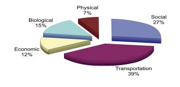
Step 5: Impact Analysis
An impact analysis was carried out for the purpose of ranking the alternatives per criterion. Potential positive and negative effects were identified, as were mitigation measures, which can effectively reduce or eliminate any predicted negative effects.
Step 6: Application of Evaluation Method
There are three stages in applying the Concordance Method:
· Performance Review: The performance of each alternative was reviewed on a criterion-by-criterion basis. The alternatives will then be ranked per criterion.
· Alternative Pair Comparison: The alternatives were compared on a pair basis (i.e., Alternative 1 versus Alternative 2, Alternative 1 versus Alternative 3, etc.), for each criterion. Based on the “weight” assigned to each criterion and the results of the Performance Review, a score would be assigned to each alternative following the pair comparison.
With this method, it is not necessary to know
how much better one alterative is over another for a particular criterion. Rather, it is only necessary to know if one
is better than the other or if they are equal for a particular criterion. The alternative that is better will be given
the weight associated with the criterion, and if both alternatives are equal,
the weight of the criterion will be divided between them.
· Calculate a Concordance Score for each Alternative: Once the pair-comparison had been completed for all alternatives and for each criterion, the concordance scores were converted to a “concordance index” for each Alternative (addition of all concordance points divided by total points available). The “concordance indices” were then added for each alternative to yield a total concordance score for each alternative. The alternative with the highest concordance score was identified as the most preferred.
Sensitivity analyses were also carried out to test the strength of the findings. These analyses involved the use of different weighting schemes, or ranking the alternatives differently for a particular criterion, or removing one or more criterion from the evaluation. The sensitivity analyses helped to understand the results of the evaluation and to identify whether the results are unduly sensitive to a particular criterion and/or ranking.
Step 7 Selection of Preliminary Preferred Alternative
2-All-purpose Lanes and 2 HOV/Bus Lanes (Alternative 3) was identified as the preliminary preferred alternative based on the foregoing evaluation and assessment procedure. This alternative, as depicted in Document 1, includes:
The overall ranking of alternatives is as follows:
1st: 2 All-purpose lanes and 2 HOV/Bus-Only-Lanes (Alternative 3)
2nd: 2-lane road (Alternative 2)
3rd : 4-lane road (Alternative 4)
4th : Do-nothing (Alternative 1)
5th : Widen Arterials and Collector (Alternative 6)
6th
: Widen Arterials (Alternative 5)
Sensitivity Analysis
Following the initial identification of the preliminary preferred alternative, a sensitivity analysis was undertaken to determine which of the criteria categories most affected the ranking of alternatives and if the category weighting were changed, how would the rankings change. The following is brief summary of the sensitivity analysis.
In summary, the sensitivity analysis supports the selection of Alternative 3, 2-all-purpose lanes and 2 HOV/bus lanes, as the preliminary preferred alternative.
ALTERNATIVE
DESIGNS (EXCERPT FROM ESR –
Chapter 6) Document 8
The Preferred Solution to providing additional transportation system capacity through the AVTC study area, for the Official Plan horizon year of 2021, is a four-lane facility, of which one vehicle lane in each direction is reserved for High Occupancy Vehicles (HOV) and buses. A major recreational pathway would also be an integral part of the solution. This facility would link Conroy Road (at Walkley Road) at the south end of the Corridor with Nicholas Street (at the Hwy 417 interchange) at the north end of the Corridor. The next phase of the EA process identified and evaluated a set of reasonable alternative designs to implement the Preferred Solution. A detailed report entitled, Evaluation Of Alternative Designs and Assessment of The Preferred Design April 2005" (Appendix G) was prepared and circulated to the study TAC and PAC for review and comment. The following sub-sections summarize this phase of the EA.
Given the nature of the Preferred Solution, together with the locational influences and the Official Plan policy context for the AVTC, the following are the fundamental components and common design objectives of all alternative designs evaluated:
The following sub-sections of this report describe the various ways of applying these design objectives to the four geographic sections which together comprise the Corridor.
The South Section involves
the portion of the AVTC between Walkley Road and Smyth Road. This section is
characterized as a wide open space corridor ranging in width from approximately
150 m to more than 250 m and flanked primarily by low density residential uses
and parkland. This section of the Corridor is relatively void of physical
features that would influence facility alignment, other than existing hydro
transmission towers that should be avoided when possible. These are the main
features that would influence the design and evaluation of the alternatives.
In addition to the common design objectives, the area-specific design objectives for the South Section are to:
The design variables for
this section are based on alignment location and curvature, and median
treatment. It is important to note that
these designs should be considered as “concepts”. Specific details such as setbacks from adjacent land uses, or the
curvatures selected, or the width of medians should be viewed as examples only,
and not precise. The objective of the
alternative designs is to enable an evaluation of them at a conceptual level,
with details to follow when the Preferred Design is refined.
South
Section Alternative Design 1: Central Alignment with Narrow Median
The defining characteristics of this alternative (Figure 6-1) are as follows:
South Section Alternative Design 2: Central Alignment
with Wide Landscaped Median
The defining characteristics of this alternative (Figure 6-2) are as follows:
South
Section Alternative Design 3: Meandering Alignment and Narrow Median
The defining characteristics of this alternative (Figure 6-3) are as follows:
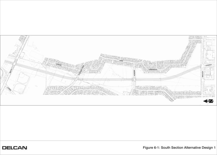
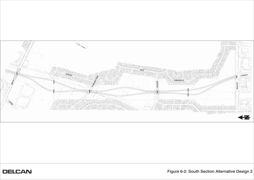
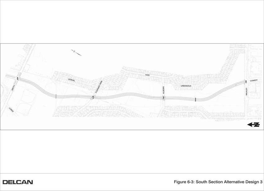
The Central Section
encompasses the portion of the AVTC between Smyth Road and Alta Vista
Drive. This section is characterized as
an approximately 90 m wide open space corridor flanked by the Ottawa Hospital
Complex to the south and west, and by a high school and technology park to the
east. An approximately 30 m to 50 m
wide hydro corridor runs along the east and north sides of the Corridor. Primarily low density residential,
institutional, and parkland uses exist to the north of the Hydro corridor, in
the Riverview Park Community. The
Hospital Woods is a valued environmental feature located in the northeast corner
of this Corridor section. These are the
key features that would influence the design and evaluation of the
alternatives.
In addition to the common
design objectives, the area-specific design objectives for this section are to:
Similar to the South
Section, the design variables for this section are alignment location and
curvature, and median treatment. Based
on these variables, four alternative designs were developed for
evaluation.
Central Section Alternative Design 1: Central
Alignment, Narrow Median
The defining characteristics of this alternative (Figure 6-4) are as follows:
Central Section Alternative Design 2: Central
Alignment, Wide Landscaped Median
The defining characteristics of this alternative (Figure 6-5) are as follows:
Central Section Alternative Design 3: Meandering
Alignment, Narrow Median
The defining characteristics of this alternative (Figure 6-6) are as follows:
Central
Section Alternative Design 4: Shared Use of Ring Road
The defining characteristics of this alternative (Figure 6-7) are as follows:
The Riverside Section
involves the portion of the AVTC between Alta Vista Drive and the approach to
the Rideau River crossing. This section
is characterized by the complexity of routing a facility that intersects with
Alta Vista Drive and crosses the CN Rail line, the Southeast Transitway, Old
Riverside Drive, and Riverside Drive.
Existing hydro towers and the adjacency of apartment buildings are also
important features to be considered.
West of Riverside Drive, the alignment must have regard for a landfill
area, the Rideau River Park Woods, and the Rideau River shoreline and flood
plain on the east and south side of the River.
These are the key features that would influence the design and
evaluation of the alternatives.
In addition to the common design objectives, the area-specific design objectives for this section are to:
Given the nature of the design influences and objectives for this Section of the AVTC, the range of alternative design approaches is restricted. Design variables for this section are primarily alternative means of connecting to and crossing the realigned Riverside Drive. Three alternative designs were developed and are described below.
The defining characteristics of this alternative (Figure 6-8) are as follows:
This design (Figure 6-9) is similar to Alternative Design
1 for this Section except that two connections between the proposed facility
and Riverside Drive are proposed. The
first connection is a one-way westbound connection from Riverside Drive at
Hinck’s Lane to the proposed facility.
The second connection is a one-way south/eastbound off-ramp connection
from the proposed facility to realigned Riverside Drive at Frobisher Lane.
This design (Figure 6-10) is similar to Alternative Design 2 for this Section except that the connection to the proposed facility from Riverside Drive at Hinck’s Lane is not provided.
This option (Figure 6-11), that influenced the City’s acquisition of the portion of the existing AVTC between Riverside Drive and the Rideau River, involved the westerly diversion and extension of Riverside Drive (near Hinck’s Lane) across the Rideau River to a connection at the Nicholas and Hwy 417 interchange. The facility would connect with Riverside Drive in a clover-leaf format just north of Frobisher Lane. Riverside Drive and the Alta Vista Parkway would then merge into the same four-lane road for a distance of approximately 600m, before diverging back into their own corridors.
The 1994 design concept was evaluated by the Study Team and was considered to fail because the roadway geometry used at the time was not consistent with current standards, and because the short distance of Riverside Drive (between its westerly diversion and the Alta Vista Parkway clover-leaf connection to it) provided insufficient weaving and merging distance for combined traffic volumes that would be using it. Significant safety and traffic operations issues would exist, and the short merging of two at-capacity arterials for a 600 m distance would cause the common section of road and the intersections at either end to fail.
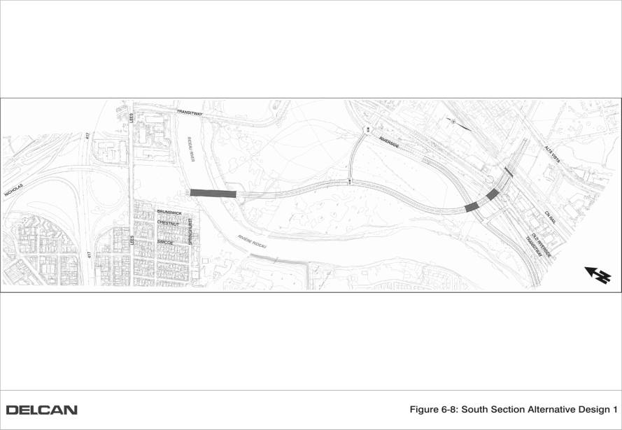
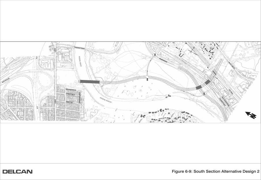
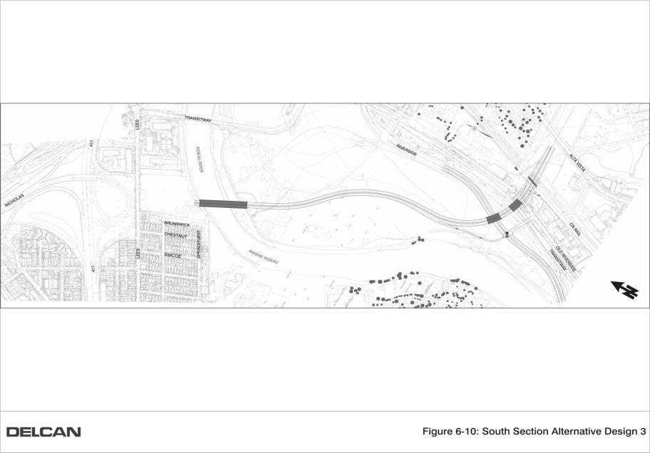
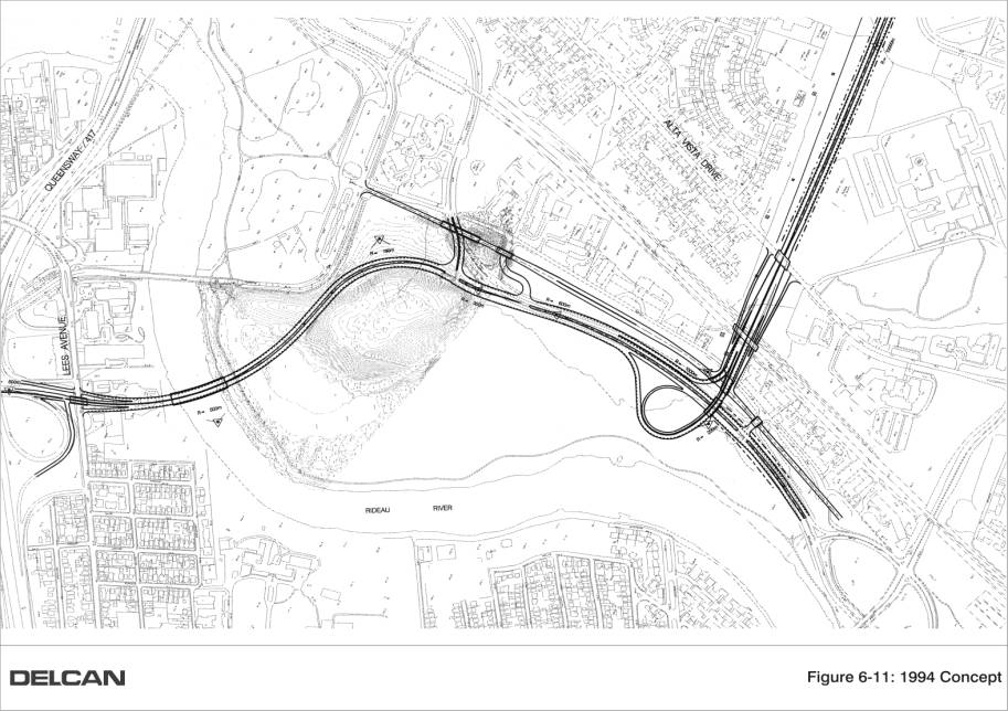
Nicholas/Lees Section Alternative Designs
The Nicholas/Lees section
involves the portion of the AVTC between the south side of the Rideau River and
the Nicholas Street interchange at Hwy 417.
North of the river, this section is characterized as a vacant open space
south of Lees Avenue that was subject to previous industrial uses and resultant
soil and groundwater contamination. The
Corridor is flanked by high-density residential apartment buildings on the east
side, and low density residential and park uses on the west side. The existing interchange north of Lees
Avenue is under the jurisdiction of MTO.
These are the key features that would influence the design and
evaluation of the alternatives.
In addition to the common design objectives, the area-specific design objectives for this section are to:
A total of eight alternative designs for this area were developed (Figure 6-12). The alternatives vary primarily in the way the proposed facility connects to Hwy 417, Nicholas Street, and Lees Avenue. Designs alternatives included variations on two basic concepts, namely: a grade-separated design that featured a free-flow “flyover” to facilitate south-to-west traffic movements; and an at-grade option that featured a pair of signalized ramp terminals located north and south of the existing Hwy. 417 overpass structure.
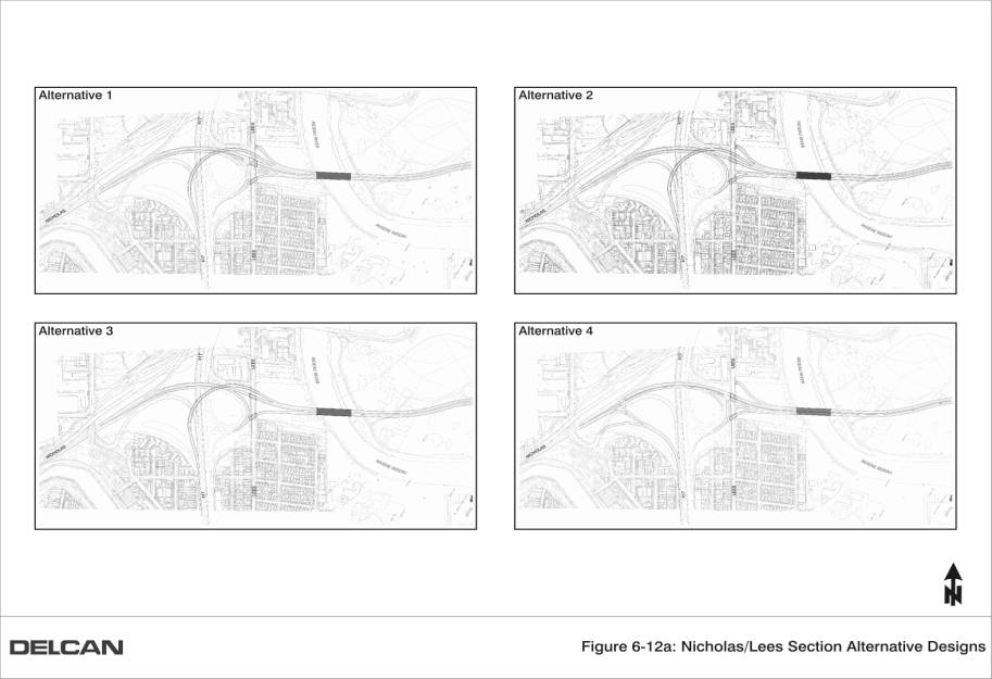
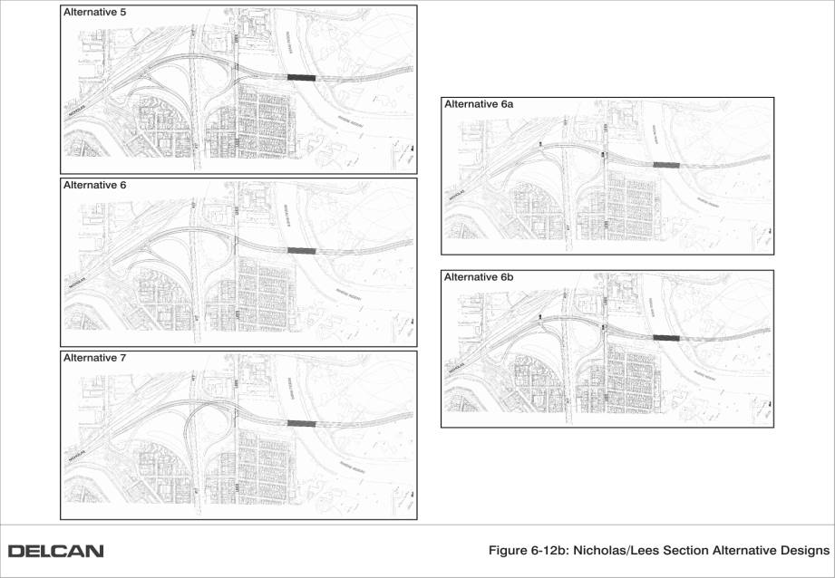
For the South and Central
Sections, the alternative designs were evaluated on the basis of the same
evaluation criteria utilized in the previous evaluation of the alternative
solutions. A comparative evaluation
approach was used, whereby each alternative design was ranked in order of
preference relative to each criterion.
The alternative designs are either, “least preferred”, “most preferred”,
“second-most preferred”, and so on.
They may also be “equally preferred” if there was no appreciable
difference in the performance of the alternatives relative to an individual
criteria. If the indicator relates to
an environmental condition that is non-existent in the study area, that
indicator is deemed “not applicable”.
The evaluation was completed by the Study Team, with input from subject
matter experts and the Advisory Committees.
Following the comparative evaluation, a numerical rating was applied to the results for each criterion. A score of 1 is assigned to an alternative if it is most preferred or equally preferred. A score of 2 is assigned to the next lowest preference ranking; a score of 3 is assigned to the next lowest preference ranking, and so on. A summary of these total scores then provides a useful benchmark of how well each alternative performs in relation to the others.
Table 6-1 below provides a
summary of the scoring results, presented by criteria grouping. A criteria
score of 1 is assigned to an alternative if it is most preferred, equally
preferred, or not applicable. A criteria
score of 2 is assigned to the next lowest preference ranking, a score of 3 is
assigned to the next lowest preference ranking, and so on. On this basis, an alternative that receives
a lower score value is more-preferred in comparison to others with higher score
values.
Table 6.1:
Evaluation Scoring of South Section Alternative Designs
|
Criteria Grouping |
SOUTH SECTION
EVALUATION SCORING RESULTS1 |
||
|
Alternative 1 Central Alignment, Narrow Median |
Alternative
Design 2 Central Alignment, Wide Landscaped Median |
Alternative
Design 3 Meandering Alignment, Narrow Median |
|
|
A. Social |
17 |
15 |
15 |
|
B. Transportation |
7 |
5 |
6 |
|
C. Economic |
2 |
6 |
4 |
|
D. Biological |
5 |
5 |
5 |
|
E. Physical |
3 |
3 |
3 |
|
TOTAL |
34 |
34 |
33 |
Note 1: Lower score values
represent a greater preference.
Based on the total scoring
results using all criteria, Alternative 3 is most-preferred (lowest score
value), although Alternatives 1 and 2 were close behind. If the economic criteria are not considered,
Alternative 2 is preferred, Alternative 3 is close behind, and Alternative 1
lags considerably behind. Alternative
Design 2 is more-preferred in the social and transportation criteria groupings,
and these are groupings that were given the higher weightings by TAC and PAC in
the previous evaluation of Alternative Solutions. When the weightings are taken into account for the criteria
groups, Alternative 2 is preferred.
Table 6-2 below provides a
summary of the scoring results, presented by criteria grouping. Based on the total scoring results using all
criteria, Alternatives 1 and 3 are tied in comparative preference, and
Alternative 2 is close behind. However,
if the economic criteria are not considered, Alternative 2 is preferred, with
Alternative 3 close behind.
Table 6.2: Evaluation Scoring of Central Section
Alternative Designs
|
Criteria Grouping |
CENTRAL
SECTION EVALUATION SCORING RESULTS1 |
|||
|
Alternative 1 Central Alignment, Narrow Median |
Alternative Design
2 Central
Alignment, Wide Landscaped Median |
Alternative
Design 3 Meandering Alignment, Narrow Median |
Alternative
Design 4 Shared Use of Ring Road |
|
|
A. Social |
18 |
17 |
17 |
21 |
|
B. Transportation |
7 |
5 |
6 |
12 |
|
C. Economic |
2 |
6 |
4 |
8 |
|
D. Biological |
7 |
7 |
7 |
5 |
|
E. Physical |
3 |
3 |
3 |
3 |
|
TOTAL |
37 |
38 |
37 |
49 |
Note 1: Lower score
values represent a greater preference.
Because the difference in
costs between Alternatives 1, 2 and 3 are assumed to be relatively negligible
in relation to the overall project cost, it is reasonable to give greater
consideration to the second total (without economic criteria). It is also important to note that
Alternative Design 2 is more-preferred in the social and transportation criteria
groupings than Alternative 1. Although tied with Alternative 3 in relation to
the social criteria grouping, Alternative 2 is more preferred in the
transportation criteria grouping. These
groupings were given the higher weightings by TAC and PAC in the previous
evaluation of Alternative Solutions.
From this evaluation,
Alternative Design 2 is the Preferred Alternative that will be taken forward
for further refinement. The option is
capable of accommodating a scenic landscaped environment, and creating a
parkway-like facility where vehicle speeds can be better managed. In relation to matters where this preferred
alternative was less favoured than another, reasonable mitigation measures are
possible that can effectively negate or diminish the relative difference in
preference.
The evaluation considered all of the same criteria, but is reported in narrative fashion as opposed to using a tabular scoring system. This is because the distinguishing features of the alternatives are primarily related to more technical facility design and transportation planning matters.
The three alternatives for
the Riverside Section followed the same alignment and general functional
design. Their variation was limited
only to the way the proposed facility would connect to Riverside Drive. Accordingly, they each shared similar
potential environmental effects on matters pertaining to social, economic,
biological, and physical criteria groupings.
Notable potential environmental effects common to these three
alternatives include:
These and other matters may require mitigation, as outlined in Section 6. However, none of these matters would influence the selection of a preferred alternative of the three alternatives evaluated.
In addition, all three alternatives require land acquisition from the NCC (for the alignment west of Riverside Drive). Through preliminary discussions between the City and the NCC during the evaluation of alternative designs, the NCC foresees no significant barriers to the acquisition of the right-of-way required to implement the Preferred Design for this section. Furthermore, communications with Hydro One have determined that hydro tower relocations and property easement/acquisition should not be viewed as barriers to implementing the Preferred Design for this Section.
Of the three alternatives, Alternative Design 2 (with the addition of two-way traffic on the Hinck’s Lane intersection) is preferred for the reason that, when compared to Alternative Designs 1 and 3, this alternative provided the best opportunity for vehicle connectivity to Riverside Drive. The distribution of facility traffic between the two Riverside Drive intersections (as opposed to one) reduces the load at any one point and results in the best overall network operation.
The eight alternatives for
this section vary primarily in the way they connect to Hwy 417, Nicholas
Street, and Lees Avenue. Accordingly,
they each shared similar potential environmental effects on matters pertaining
to social, economic, biological, and physical criteria groupings that would not
influence the selection of a preferred design.
Notable potential environmental effects common to these three
alternatives include:
One of the key area-specific design objectives for this portion of the Corridor is to connect the facility with the Hwy 417 interchange at Nicholas Street in a manner that accommodates the critical south to west and west to south movements, without adversely affecting the mainline traffic operations of Hwy 417 through this area. Since the Ontario Ministry of Transportation (MTO) has jurisdiction of the highway and interchange, their involvement in the evaluation and selection of the Preferred Alternative was essential.
The alternatives were presented to MTO for consideration. Alternative Designs 1 through 5, which include a free flow ramp, were determined to be unacceptable as they significantly reduced the length of weave / merge lanes section resulting in merging volumes that could not be processed.
Alternative 6A had merge distance problems for the southbound on-ramp movements for both Nicholas Street and Greenfield Avenue, which were forced to merge over a very short distance before joining with the northbound to westbound on-ramp.
Alternative 6B addresses these merge/weave issues in the northwest quadrant of the interchange, and was recommended as the preferred alternative. This alternative also included traffic signals at both ramp terminals with Nicholas Street. This helps to meter traffic to/from the highway, and will also help to reduce vehicle speeds along Nicholas Street.
Alternative 6B also includes ramps to/from Lees Avenue. From a traffic perspective, these ramps are considered beneficial as they would provide improved accessibility to the University of Ottawa and to Sandy Hill (primarily via Robinson). This improved linkage would reduce traffic volumes on Laurier Avenue, Nicholas Street and Main Street for traffic to/from Sandy Hill, the University of Ottawa, and southeast Ottawa. Existing peak period turning restrictions at the Main/Lees intersections would reduce the potential for the traffic increases on the section of Lees Avenue west of the AVTC. The ramps are also required to provide a northern terminus for the on-road bicycle lanes and the adjacent sidewalks on the AVTC. From this point northerly, pedestrians and cyclists can use the systems provided on Lees Avenue and on adjacent/connecting streets, in a much safer environment than would exist through the interchange area. If necessary, there is the option to consider turning movement prohibitions for some movements at the Lees Avenue ramp terminals.
Following the review of the traffic projections and analysis of the interchange alternatives, the MTO agreed in principle that Alternative 6B was an acceptable alternative to move forward with in this assessment. However, this response was from the perspective of its compatibility with their existing and possible future plans for this section of the Hwy 417 and would require additional examination closer to the time of implementation.
On the basis of all of the
above, Alternative Design 6B is determined to be the Preferred Alternative for
the Nicholas/Lees Section.
In addition to connecting to Hwy 417 at Nicholas, and intersecting with Walkley Road at Conroy Road, the facility crosses one local road (Old Riverside Drive), two designated collector roads (Kilborn Avenue and Pleasant Park Road), one major collector road (Alta Vista Drive), and two arterial roads (Smyth Road and Riverside Drive).
There are various design
options available at these intersections.
As the intersection design choices are in some cases interchangeable
between the various alternative alignments, these options are evaluated as a
separate exercise. In this way, the
variable benefits and disbenefits of each intersection option can be determined
independently from the facility alignment design. Following this evaluation, the preferred intersection designs can
then be matched with the preferred facility designs at each intersection,
leading to a preferred overall design.
Four (4) alternative intersection designs were illustrated with the
alternative facility alignment designs for the South and Central Sections, and
are described as follows.
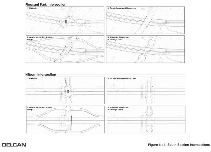
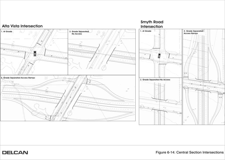
Alternative Intersection Design 1: At Grade
This represents a typical arterial or collector road intersection where traffic movements across and between intersecting roads occur at-grade and are controlled by STOP signs or traffic signals.
Alternative Intersection Design 2: Grade-Separated, with
Connection Ramps
This represents a separation of intersecting roads whereby one road passes over or under the other, and traffic movements between each road are accommodated by on/off ramps whose connections to the cross-street are controlled by STOP signs or traffic signals. As a result, each road operates at relatively free-flow conditions.
Alternative
Intersection Design 3: Grade Separated, no Connection Ramps
This represents a separation of intersecting roads whereby one road passes over or under the other, and traffic movements between each road are not possible.
Alternative Intersection Design 4: At
Grade, No Side-Access
This represents a priority
given to the dominant road, with the intersecting road being terminated, by the
use of cul-de-sacs, on either side of the dominant road.
The Alternative Intersection Designs were evaluated based on the criteria used throughout this assessment with a particular focus on the following criteria:
After considering their performance relative to the criteria, Alternative Intersection Design 1 (at-grade traffic signal controlled intersection) is preferred at each of the proposed facility’s intersections from Walkley Road through to and including Alta Vista Drive. The following are the main reasons:
AVTC/Alta Vista Drive
Intersection
One intersection location of considerable interest to area residents is the AVTC/Alta Vista Drive intersection. The current recommendation is that this intersection be at-grade to allow maximum mobility options for travelers to/from the Ottawa Hospital Complex, thereby reducing use of Smyth Road and the Alta Vista/Smyth intersection. Concern has been expressed by residents of the Riverview Community to the north that this intersection will attract additional vehicles to Alta Vista Drive between the AVTC and Industrial Avenue, and as such, they preferred a grade separation with no, or minimal, interaction between the AVTC facility and Alta Vista Drive.
In response to the residents concerns, the following remarks were offered:
There are a number of significant factors that weighted against the grade-separated alternative being recommended. These include:
· Three major service relocations would be required;
· Other additional servicing works (watermain and stormwater management pond) would be necessary;
· The vertical profile results in an increase in earthwork, assuming 3H:1V sideslopes in earth and 1H:2V sideslopes in shale, with a cost of approximately $1.5 million;
· From a geotechnical perspective there are problems associated with excavating an open cut into the shale rock and local water table lowering and water infiltration;
· Re-location of the overhead high voltage power lines with retaining wall protection;
· Traffic to/from Riverside Drive or from Downtown could not connect to Alta Vista Drive at this location due to the inability to provide certain access ramps; and
· The total cost of this alternative is approximately $9.0 million.
Two alternatives were considered pertaining to the profile of the facility between intersections in the South Section. The first alternative is the standard facility design whereby the road surface is either at or slightly elevated relative to adjacent road grades. The second alternative is a road surface that would be depressed relative to adjacent road grades.
The concept of lowering the roadway was considered as it could potentially assist in lessening noise and visual effects. It would also have the benefit of creating a surplus of earth fill that could be utilized for roadside berm construction. Following an evaluation of the two alternatives based on the criteria established for this EA, the first alternative (standard road profile) is recommended for the following reasons:
· Depressing the road surface would create the potential for unsafe driving conditions due to snow drifting and accumulation as well as an increased risk of flooding;
· Deeper excavation leading to poorer soil conditions;
· Potential lowering of the groundwater table and the requirement for dewatering, and possible settlement;
· Unless the road surface was deeply depressed (i.e., 2 m or more), there would likely still be a requirement for noise attenuation;
· Intersections spacing ranges from 300 m to 700m, and because a depressed facility would need to rise back to grade at intersections, a very undesirable “roller coaster” type profile/ride would be created; and
· Constructing a depressed facility and providing appropriate drainage during and after construction would be very expensive.