Report to / Rapport au :
Comité du transport,
Submitted by / Soumis par : Nancy Schepers, Deputy City Manager / Directrice
municipale adjointe,
Planning, Transit and the
Environment/ Urbanisme, Transport en commun et Environnement
Contact Person /
Personne ressource : Vivi Chi, Manager / Gestionnaire, Transportation and
Infrastructure Planning / Transports et planification des infrastructures
Planning, Environment and
Infrastructure Policy/ Politiques d’urbanisme, d’environnement et
d’infrastructure
(613) 580-2424 x21877,
vivi.chi@ottawa.ca
REPORT RECOMMENDATION
That the Transportation Committee approve the Statement of Work for the Prince of Wales Drive (Fisher to Woodroffe) Widening Environmental Assessment as detailed in Document 1.
RECOMMANDATION DU RAPPORT
Que le
Comité des transports approuve l’énoncé des travaux relatif à l’évaluation
environnementale concernant l’élargissement de la promenade Prince of
Wales (de Fisher à Woodroffe), tel que détaillé dans le document 1.
BACKGROUND
The South Urban Community (SUC) is one of the three major urban development areas located outside the Greenbelt and is comprised of Barrhaven and Riverside South. Over time the population and the number of jobs in the SUC is expected to grow substantially. A significant portion of this growth will take place in Barrhaven.
When it is considered that the majority of the City’s employment centres will continue to be located inside the Greenbelt, the result is increased transportation demand to cross the Greenbelt. Hence, the 2003 Transportation Master Plan (TMP) identified the widening of Prince of Wales Drive from two to four lanes from Fisher Avenue to Woodroffe Avenue (10.3 km) as one of the projects required to accommodate growth in Barrhaven as well as southern rural communities such as Manotick, and to accommodate trips to inside the Greenbelt. The projected timing of the Prince of Wales Drive project was identified as Phase 2 (by about 2013) in the TMP. Figure 1 illustrates the location of the proposed road widening in relation to the major urban development areas.
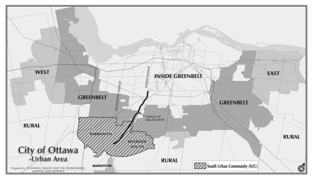
Figure 1 Location of Project
The South Nepean Urban Area Secondary Plan referred to Prince of Wales Drive as a strategic arterial road, along with Jockvale, Greenbank, and Cedarview Roads. This environmental assessment study will complete the planning component for the arterial road network in the SUC. Other completed studies include the widening of Merivale/Fallowfield Roads, Greenbank Road (Malvern to Cambrian), Woodroffe Avenue (Stoneway to Strandherd) and the on-going Environmental Assessment (EA) for the widening and re-alignment of Jockvale Road (Jock River to Prince of Wales Drive).
The City has recently completed Community Design Plans (CDP) for specific areas in the SUC, namely the South Nepean Town Centre CDP, the Barrhaven South CDP and its associated transportation master plan, and the Riverside South CDP. Although they do not directly abut Prince of Wales Drive, they provide key information with respect to growth and development in the SUC which can affect traffic levels and patterns on and around Prince of Wales Drive. As well, development applications are currently underway in the SUC. They include the development of residential and commercial subdivisions, and site selection for other infrastructure such as storm water management facilities, major utilities etc.
DISCUSSION
The attached Statement of Work outlines the tasks to be undertaken for the environmental assessment study, and upon approval from Transportation Committee, will form the basis for a call for proposals to the consulting industry.
This project will be carried out as a Schedule ‘C’ Class EA as described in the June 2000 Municipal Engineers Association: “Municipal Class Environmental Assessment” document. As this project involves potential road widenings onto federally owned lands, or the need for federal permits, there is also a requirement for federal review under the Canadian Environmental Assessment Act (CEAA). A coordinated process that satisfies both Provincial and Federal EA acts will be carried out to avoid duplication of effort wherever possible.
The primary study area will follow the proposed corridor as shown in the Official Plan, from the Fisher Avenue intersection south 10.3 km to the Woodroffe Avenue intersection. Some tasks will require study of a broader area, such as drainage, downstream transportation effects and noise impacts. Therefore the study area will be adjusted as necessary, in order to appropriately address issues that arise during the study.
Key considerations for the Prince of Wales Drive study include the following:
- the needs assessment for the widening and examination of the resulting traffic impacts;
- the provision of access to existing and planned developments along the corridor;
- impacts on/access to farming operations on National Capital Commission ( NCC) lands;
- the requirement to widen the existing Canadian National Railway (CNR)/VIA Rail overpass located just south of Colonnade Road;
- the planning of intersections such as the Strandherd Drive, Merivale Road, Hunt Club Road, Fallowfield Road, and Colonnade Road, to improve safety and ensure sustainable traffic management strategies;
- the future closure and removal of the Woodroffe Avenue/Prince of Wales intersection from the arterial road network;
- pedestrian and cycling needs, including the planning of the intersection;
- the planning of the intersection with future NCC Greenbelt pathway;
- timing and transportation impacts of the future Strandherd/Armstrong Bridge;
- the potential for an additional future Rideau River crossing as identified in the TMP;
- impacts on the Rideau Canal system and the fact it is considered for World Heritage Status;
- impacts on Parks Canada lands and the Black Rapids Locks station considering they are National Historic Sites; and
- the upcoming relocation of the Royal Canadian Mounted Police (RCMP) to the former JDS building on Merivale Road;
- anticipated growth in the rural villages to the south; and
- transit priority opportunities
ENVIRONMENTAL
IMPLICATIONS:
The study will examine and evaluate the project's effects on the social, physical, and natural environments within the study area. Appropriate mitigation measures will be developed and post mitigation environmental impacts will also be determined.
RURAL
IMPLICATIONS:
The EA study area lies entirely within the city’s urban boundary. However, as this section of Prince of Wales Drive crosses the Greenbelt, the potential impact of any widening on the rural character and active farming operations on NCC Greenbelt Lands will be an important factor in the study, and will be evaluated in coordination with the NCC. In addition, traffic demand originating from existing and future residents of the rural area will be incorporated into the study process.
CONSULTATION
Consultation with stakeholders, public agencies, and individuals will be an integral component of the EA study. The consultation process will include meetings with key stakeholders through the Agency Consultation Group and the Public Consultation Group. Consultation with the general public will occur principally through open houses, but also through the project web page, e-mail and additional meetings as required.
FINANCIAL IMPLICATIONS
Funds are available in the 2007 Capital Budget, Order No. 902559 - Environmental Assessment Studies - Arterial Roads.
SUPPORTING DOCUMENTATION
Document 1 Prince of Wales Drive Widening (Fisher Avenue to Woodroffe Avenue) Environmental Assessment Study – Statement of Work
DISPOSITION
Following Committee approval of the attached Statement of Work, the consultant selection process will commence in accordance with established City practice for the acquisition of services. Request for Qualifications and subsequently a Request for Proposals process will be utilized. It is expected that 24 months will be required to complete the study.
PRINCE OF WALES DRIVE WIDENING (FISHER AVENUE TO WOODROFFE
AVENUE) ENVIRONMENTAL ASSESSMENT STUDY – STATEMENT OF WORK DOCUMENT 1
City of Ottawa
Prince of Wales Drive Widening (Fisher Avenue
to Woodroffe Avenue)
Environmental Assessment Study
STATEMENT OF WORK
INTRODUCTION
The City of Ottawa is the proponent of a Class Environmental Assessment (EA) to study the proposed widening of Prince of Wales Drive from Fisher Avenue to Woodroffe Avenue. This Statement of Work (SoW) describes the City’s intentions with respect to the methodology, public consultation and deliverables for this study.
PLANNING
CONTEXT
The South Urban Community
(SUC) is one of the three major urban development areas located outside the
Greenbelt and is comprised of Barrhaven and Riverside South. The population of
the SUC is expected to grow to four times its current level (42,000 to 172,000)
while the number of jobs in the area is expected to grow to approximately eight
times its current level (8,000 to 70,000). In fact, the
population growth in the SUC is expected to be the highest among all areas
located outside the Greenbelt. A significant portion of this growth will take
place in Barrhaven.
When it is considered that
the majority of the City’s employment centres will continue to be located
inside the Greenbelt, the result is additional transportation demand crossing
the Greenbelt. Hence, the 2003 Transportation Master Plan (TMP)
identified the widening of Prince of Wales Drive from two to four lanes from
Fisher Avenue to Woodroffe Avenue (10.3 km) as one of the key projects required
to accommodate growth in Barrhaven as well as southern rural communities such
as Manotick, and to accommodate trips to inside the Greenbelt. The TMP
identified the Prince of Wales Drive widening as a Phase 2 project (completion
by about 2013). Figure 1 illustrates the location of the proposed road
widening in relation to the major urban development areas.
The South Nepean Urban Area
Secondary Plan referred to Prince of Wales Drive as a strategic arterial road,
along with Jockvale, Greenbank, and Cedarview Roads. This study will complete
the planning component for the arterial road network in the SUC, complimenting
completed EAs for the widening of Merivale/Fallowfield Roads, Greenbank Road
(Malvern to Cambrian), Woodroffe Avenue (Stoneway to Strandherd) and the
on-going EA for the widening and re-alignment of Jockvale Road (Jock River to
Prince of Wales).
The City has recently completed Community Design Plans (CDPs) for specific areas in the SUC, namely the South Nepean Town Centre CDP, the Barrhaven South CDP and its associated Transportation Master Plan, and the Riverside South CDP. Although they do not directly abut Prince of Wales Drive, they may provide key information with respect to growth and development in the SUC directly impacting traffic levels and patterns on and around Prince of Wales Drive. As well, development applications are currently underway in the SUC. They include the development of residential and commercial subdivisions, and site selection for other infrastructure such as storm water management facilities, major utilities etc.

Figure 1 Location of Project
Key considerations for the Prince of Wales Drive study include the following:
· the needs assessment for the widening and examination of the resulting traffic impacts;
· the provision of access to existing and planned developments along the corridor;
· impacts on/access to farming operations on National Capital Commission ( NCC) lands;
· the requirement to widen the existing Canadian National Railway (CNR)/VIA Rail overpass located just south of Colonnade Road;
· the planning of intersections such as the Strandherd Drive, Merivale Road, Hunt Club Road, Fallowfield Road, and Colonnade Road, to improve safety and ensure sustainable traffic management strategies;
· the future closure and removal of the Woodroffe Avenue/Prince of Wales intersection from the arterial road network;
· pedestrian and cycling needs, including the planning of the intersection;
· the planning of the intersection with future NCC Greenbelt pathway;
· timing and transportation impacts of the future Strandherd/Armstrong Bridge;
· the potential for an additional future Rideau River crossing as identified in the TMP;
· impacts on the Rideau Canal system and the fact it is considered for World Heritage Status;
· impacts on Parks Canada lands and the Black Rapids Locks station considering they are National Historic Sites; and
· the upcoming relocation of the Royal Canadian Mounted Police (RCMP) to the former JDS building on Merivale Road;
· anticipated growth in the rural villages to the south; and
· transit priority opportunities
PROJECT SCOPE, TASKS, AND DELIVERABLES
1. General
This project will be carried out as a Schedule ‘C’ Class EA as described in the June 2000 Municipal Engineers Association: “Municipal Class Environmental Assessment” document. As this project involves potential road widenings onto federally owned lands, or the need for federal permits, there is also a requirement for federal review under the Canadian Environmental Assessment Act (CEAA). A coordinated process that satisfies both provincial and federal EA acts will be carried out to avoid duplication of effort wherever possible.
1.1 Study Area
The primary study area
(shown in figure 2) will follow the proposed corridor as shown in the Official
Plan, from Fisher Avenue to Woodroffe Avenue. Some tasks will require study of
a broader area, such as the drainage, downstream transportation effects and
noise impacts. Therefore the study area will be adjusted as necessary, in order
to appropriately identify the influences on, and the effects of the
undertaking.
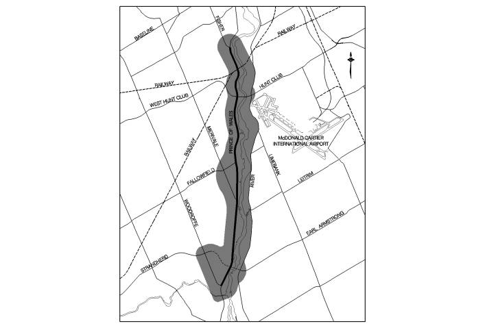 Figure
2
Proposed Study Area
Figure
2
Proposed Study Area
1.2 Timing
The study will be completed within approximately 24 months.
1.3 Coordination
with Concurrent Studies
The EA Study process will take into consideration any information including analysis and preliminary findings of concurrent on-going transportation, development and infrastructure projects that could influence the direction and/or conclusions of the Study. These projects include:
· Jockvale Road Widening EA Study – Jock River to Prince of Wales Drive
· Jockvale-Longfields Link EA study – Strandherd Drive to the Jock River
· Strandherd Drive Extension (Woodroffe to Prince of Wales) – Detailed Design
· The Mayor’s Task Force on Transportation
· Official Plan and Transportation Master Plan Review and 2008 Update
· Current development applications and associated studies (i.e. transportation impact studies)
1.4 Background
Material
Relevant background material will be collected and reviewed. This includes:
· City of Ottawa Official Plan, Transportation Master Plan and Infrastructure Master Plan (2003).
· The Rapid Transit Expansion Study (RTES)
· Ottawa Rapid Transit Expansion Program (ORTEP) Implementation Strategy
· South Nepean Urban Area Secondary Plan (June 1997)
· South Nepean Town Center CDP (2006)
· Barrhaven South CDP & Transportation Master Plan (2006)
· North-South Corridor LRT Project (Rideau Centre to Barrhaven Town Centre) EA (2005)
· Southwest Transitway Extension (Strandherd to Cambrian) EA Study (2006)
· Merivale Road (Slack Road to Prince of Wales Drive) and Fallowfield Road (Woodroffe Avenue to Prince of Wales) Widening Class EA (2004)
· Greenbank Road Widening (Malvern to Cambrian) EA (2006)
· Woodroffe Avenue Widening (Stoneway to Strandherd Drive) EA (2001)
· Rideau River Bridge Location Feasibility Study (1993) and Addendum (1997)
· Cumulative Impacts of Planned Transportation Infrastructure on the Southern Farm Sector of the Greenbelt (2004)
·
Fallowfield Road/ Rideau River Crossing Feasibility Study and Environmental Overview –
Functional Design report (1992)
·
NCC
Greenbelt Pathway Crossing Analysis
· City policies/guidelines/practices
· Travel surveys and traffic counts including travel demand forecasts and origin/destination data
· Population, employment and development projections
· Current and past development applications and associated studies (e.g. traffic and noise)
· Property ownership (and tenants), easements and rights-of-way information
· Natural environment studies, such as the Urban Natural Areas Environmental Evaluation Study (2005)
· Relevant economic development studies
· Relevant water, wastewater and storm water management studies, such as Lower Rideau Watershed Strategy (Aquafor Beech, Robinson, September 2005) and Jock River Reach 1 Subwatershed Study (pending - May/June 2007).
· Relevant stream crossing information (fisheries, water quality, etc…)
· Regional Road Corridor Design Guidelines
· Draft City pedestrian and cycling plans
· Current and planned transit priority opportunities
1.5 Summary
of Deliverables
The deliverables for the study include:
- Study Design and Schedule Document
- Public Open House Summary Report – one for each of three Public Open Houses
- Project Update Newsletter – minimum of three
- Draft and final Environmental Study Report (ESR)
- Plan and Profile functional design drawings of the Recommended Plan, including railway overpass details, roadway drainage and interim/permanent storm water management requirements, and other associated infrastructure
- Preliminary approvals for storm water management facilities, grade separations, etc
- Project capital and maintenance costs in Work Breakdown Structure (WBS) format (baseline budget)
2. Study Design
As a first task, a Study Design will be developed to ensure that all aspects of the EA will be addressed. Part of this task will be to liaise with the Provincial and Federal authorities responsible for EA reviews to obtain their input on what EA requirements must be met (specific to this project). The Study Design will:
- Confirm the study area
- Identify the various disciplines required to undertake the EA with expertise in areas such as:
- Air
quality
- Archaeology
- Geotechnical
- Heritage
- Landscape architecture, etc.
- Natural
environment
- Noise
- Social
environment
- Transportation planning and design
- Urban planning
- Vibration
- Describe the major tasks of the EA, including a plan for development of alternatives as well as a process for the evaluation of the alternatives
- Include a detailed public consultation program identifying the roles and responsibilities of the Study Consultation Groups, as well as timelines and communication plans for the Public Open Houses
- Highlight major milestones and decision points
- Undergo public consultation with the Consultation Groups and at the first Public Open House
2.1
Identify a List of Stakeholders
This study will involve a number of stakeholders, including community groups, property owners, businesses, institutions, approval agencies and special interest groups. Early in the study process stakeholders shall be identified. This shall be accomplished through various forms of consultation, including liaison with City Councillors, community associations, approval agencies and public notification.
2.2
Consultation Program
This study will examine a wide range of technical, social and environmental issues and will incorporate a broad number of community and business interests. The success of this effort is contingent on an effective, comprehensive and timely consultation program.
The consultation process will include meetings with key stakeholders through an Agency Consultation Group (ACG) and a Public Consultation Group (PCG). The membership, roles and responsibilities of these groups shall be refined through the Study Design, and include a general invitation to all City Advisory Committees.
Consultation with the general public shall occur principally through Public Open Houses, but also through the project Web page and by e-mail. Additional meetings with specific agencies, groups or individuals will be held as required in order to address any particular issues as they may arise.
The study consultation program shall be confirmed during the development of the Study Design and shall be documented within the ESR accordingly.
3. Environmental Assessment
The second step in this study is the undertaking of the actual Environmental Assessment. It comprises the following tasks outlined below.
3.1 Project Need
The need to widen Prince of Wales Drive from Fisher Avenue to Woodroffe Avenue (10.3 km) was identified in the TMP as a preferred solution to partially address future vehicle transportation demand to and from the South Urban Community and the southern rural communities, and to improve safety along this corridor. It has been identified as a Phase 2 (by about 2013) project. In order to reaffirm the conclusions of the TMP, the EA Study will include a detailed re-examination of the need to widen this road.
3.2 Alternative Solutions
The Study will identify and examine all reasonable alternatives to the road widening.
The key components of this stage include:
- Identify and assess existing and future travel demand
- Identify current and projected transportation problems and opportunities within the study area
- Identify alternative solutions to address transportation problems including
- Do nothing
- Expand and enhance public transit service (including Park & Ride Facilities) to/from the SUC
- Expand and enhance cycling routes
- Implement transportation demand management (TDM) measures to reduce travel demand
- Expand other arterial roadways in the north-south direction
- Develop evaluation criteria and indicators to assess the impacts (with consideration to possible mitigation measures) on the environment by the various solutions
- Analyze and evaluate the alternative solutions and select the preferred solution(s)
The different alternative solutions and designs will be developed with input from the Consultation Groups and will be presented to the public for comments at several Public Open Houses throughout the study (see section 4 on Public Consultation Plan). Developing and examining a full range of options complies with the EA Act requirement that alternative solutions for the undertaking be assessed.
The travel-forecasting component included in this stage of the EA must:
- Identify the needs for all modes of transportation including walking, cycling, transit, auto and truck;
- Incorporate the principles (e.g. mode share targets etc.) of the current OP and TMP in balancing demand to capacity while promoting the desire to increase transit use, and appropriate land uses. A re-evaluation of the travel demand shall be undertaken should any changes to these principles be brought about through the 2008 OP and TMP update;
- Consider the implications of corridor specific issues, such as the implications of the construction of the Strandherd/Armstrong Bridge, as well as needs and/or constraints on connecting roadways (e.g. Fisher Avenue, Colonnade Road, Hunt Club Road, Fallowfield Road, Merivale Road, Crestway Drive, future Strandherd Drive, Woodroffe Avenue); and
- Provide supporting analysis and recommendations for the staging of construction and alternative or supporting infrastructure (e.g. key intersection improvements etc.)
3.3 Environmental
Inventory
An inventory of the social, economic (agricultural, employment, retail etc.), physical and natural environments within the study area will be compiled. The inventory will consider all available background material and where necessary, supplement this information through on-site surveys and/or detailed studies. The inventory must be of sufficient detail to enable the analysis and evaluation of alternative transportation solutions, designs and mitigating measures.
In general, the inventory will identify and describe those aspects of the environment that could potentially affect, or be affected by, the undertaking. Some of the specific aspects of the environment associated with this project include:
- Rideau River / Rideau Canal Watershed, and its associated natural recreation and heritage features
- The context of Prince of Wales Drive in the development of adjacent lands including consideration of current and future built environment
- Adjacent homes and communities including Carleton Heights, Fisher Glen, Grenfell Glen, Pine Glen, Country Place, Crestview, Rideau Glen, Havenlea, Chapman Mills, Carlton Lodge, the Village of Manotick, Hearts Desire, Stonebridge, and the South Urban Community generally
- CNR/VIA Railway Crossing
- Current and future cycling and recreational pathway corridors/routes
- Potential influence of the project from/on development patterns in the SUC
- Potential influence of the project from/on NCC lands
- Potential influence of the project from/on development patterns in the Merivale and Rideau Heights Industrial Parks
- Potential influence of the project from/on development patterns in the residential communities inside the Greenbelt
- Current storm water drainage patterns
- Utilities including water, sanitary, hydro, gas, cable, phone, fibre optic, etc.
· Noise and vibration
The existing conditions and proposed works associated with development in the South Urban Community, farming operations on NCC lands, and the industrial and residential areas inside the Greenbelt, within the study area, shall be documented prior to undertaking the evaluation of alternative solutions.
3.4 Design
Alternatives
Provided the preferred solution involves the widening of Prince of Wales Drive, the study will identify and evaluate various road design alternatives.
Roadway alignment and cross-section design alternatives will be identified based on consideration of constraints within the study area, input from the public and approval agencies, landowners, as well as City guidelines/standards/practices. All proposed designs will include any required modifications on connecting roadways (public or private).
3.5 Evaluation
Criteria and Evaluation Process
A comprehensive evaluation criteria and methodology will be developed to evaluate the various alternative designs. The inventory of existing conditions will define the scope of impacts on the environment that will need to be examined. The evaluation process will be clearly described and documented.
3.6 Impact
Assessment
The impact of each alternative design on the environment will be thoroughly evaluated. Mitigation measures, and associated implications (e.g. cost of mitigation etc.) to address environmental impacts are to be identified and considered in the evaluation process.
The study must clearly identify the initial impacts of each alternative as well as the net post-mitigation impact using quantifiable indicators and measures wherever possible.
The impacts of staged implementation from two-lane to four-lane divided will be assessed with consideration for the staging of underground utilities included in the assessment.
Impacts on traffic operations will be evaluated in accordance with current City guidelines and practices. To ensure that all impacts are appropriately evaluated, detailed studies will be required for certain issues such as:
- Air
quality
- Archaeology and heritage
- Coordination with existing homes and Urban Design
- Noise/Vibration
- Roadway drainage and storm water management
- Subsurface conditions, geotechnical and utilities
- Vegetation/terrestrial habitat and aquatic habitat
3.7
Costing
Developing an accurate project baseline budget is an essential component of this study and it will contribute to the City’s short and long range capital budget forecasting and priority setting.
The baseline budget shall be structured in approved Work Breakdown Structure (WBS) format in accordance with the City’s standard Program Management System. The WBS shall include detailed scope statements for all major project elements, which shall be identified on a WBS diagram, and shall identify all items and their costs required to complete the undertaking. The baseline budget shall also include contingency allowances.
Project costing shall be a fundamental criterion in the evaluation of alternatives and shall be key in the analysis of staging considerations and to establish implementation strategies.
3.8 Recommended Plan
Following the evaluation of alternatives and determining all necessary mitigation measures to minimize any adverse impacts of the project, the Study Team, with input from the public, landowners, and review agencies, will select and document the preferred design alternative. This will include:
· A detailed written description of the undertaking;
· Functional design drawings (1:500 scale, plan and profile) for the preferred alignment with a geo-referenced horizontal alignment, vertical profile, grading, drainage and property envelope
· Roadway cross-section drawings for typical sections as well as at critical areas (e.g. adjacent to the existing storm water management facility north of Colonnade Road, at the CNR bridge crossing, in the Greenbelt, and the Fisher Avenue, Hunt Club Road, Fallowfield Road, Merivale Road, Strandherd Drive and Woodroffe Avenue intersections, etc.). Alternative road cross-sections that may in whole or part address the required storm water management for road runoff shall be considered;
· CNR overpass structural general arrangement drawings;
· Landscape design plan;
· Property request plan;
· Recommended mitigation measures to reduce the environmental impacts of the project;
· Storm water management and roadway drainage requirements, as well as other infrastructure requirements;
· Infrastructure implementation/staging plan (e.g. water mains, sewers etc.); and
· Cost estimate of the proposed works (prepared in the WBS format)
3.9 Environmental
Study Report
The recommended design with mitigation plans will be circulated to the ACG, PCG and any other approval agencies for comment, and later presented to Transportation Committee for approval. An Environmental Study Report (ESR) will be prepared to document the entire study process including the recommended design and any appropriate mitigation plans.
The final ESR, incorporating all pertinent comments, will be prepared and placed on public record for a minimum 30-day review period. The ESR will contain a full Work Breakdown Structure (WBS). The format of the WBS will follow the City’s standard Program Management System.
4. Consultation
Consultation with public agencies, private groups, City Advisory Committees, and individuals is an integral component of this Study. The consultation process will include meetings with key stakeholders through an Agency Consultation Group (ACG) and a Public Consultation Group (PCG) and the general public through Public Open Houses. Additional meetings with specific agencies, utility corporations, CN, VIA and Ottawa Central Railroad corporations, interest groups or individuals will also be held as required in order to address any specific issues as they may arise.
A minimum of three ACG and three PCG meetings will be held during the course of the Study. Representation on the ACG and PCG will be confirmed in the Study Design.
4.1
Notifications
The public shall be notified of: the Study commencement, all Public Open Houses (POHs), and Study completion. Notifications will be sent out at appropriate stages in the Study, and each announcement will take the following forms:
· Advertisements in daily newspapers (The Ottawa Citizen, The Ottawa Sun, Le Droit)
· Advertisements in community papers where appropriate
· The project web site on the City’s web portal
4.2
Public Consultation Group
A Public Consultation Group (PCG) will be formed to enable private groups to provide direct input to the study, advising and commenting on local issues and concerns. PCG members may include representatives from local community groups, area business representatives, special interest groups, and adjacent property owners. Invitations will be forwarded to each of the following groups:
· Barrhaven Business Improvement Area
· Carleton Heights and Area Residents’ Association
· General Burns Community Association
· Glens Community Association
· Hearts Desire Community Association
· Honey Gables Development Association
· Hunt Club Community Organization
· Longfields Community Church
· Manotick Community Association
· Quinterra Riverwood Community Association
· Rideau Glen Ratepayers Association
· Riverside Park Community and Recreation Association
· Riverside South Community Association
· Southpointe Community Association
· Stonebridge Community Association
· Uplands on the Rideau Association
· Friends of the Jock River
· Other interested groups or persons identified during the development of the study design, or that come forward during the course of the study
4.3
Agency Consultation Group
An Agency Consultation Group (ACG) will be formed to provide input on planning, engineering and environmental issues and will provide general guidance to the Study Team. ACG members will include experts in their related fields from government agencies and approval bodies including, but not limited to:
· National Capital Commission (NCC)
· Transport Canada
· Parks Canada
· Rideau Valley Conservation Authority (RVCA)
· Royal Canadian Mounted Police (RCMP)
· City of Ottawa – Public Works and Services Department
-
Infrastructure
Services Branch
- Traffic and Parking Operations Branch
- Surface Operations Branch
- Utility Services Branch
· City of Ottawa – Planning Transit and the Environment Department
- Planning, Environment and Infrastructure Policy Branch
- Planning and Infrastructure Approvals Branch
- Transit Services Branch
· City of Ottawa – Community and Protective Services
- Fire Services Branch
- Paramedic Services Branch
- Parks and Recreation Branch
- Long Term Care Branch – Carleton Lodge
· Business Transformation Services Department
- Real Property Asset Management Branch
· Ottawa Police Service
4.4 Public
Open Houses
The EA assignment will include a minimum of three Public Open House (POH) meetings.
Background material and presentation material for the POH meetings will include a “Project Update Newsletter” which will summarize the information presented at the POH and will be available for general distribution.
All material presented at the POH meetings as well as the “Project Update Newsletter” will be bilingual and bilingual staff will be present during all Public Open House meetings.
An Open House summary report will be produced to document each POH including all comments received, and will form part of the final study report.
4.5 Project Web Page
A Project Information Web Page will be established for the Study on the City’s external web site. The purpose of the Web Page will be to inform the public of the progress of the study and upcoming meetings or activities, post the materials presented at each Open House, and provide a point of contact for e-mail correspondence.
4.6 Frequently
Asked Questions Document
To assist in providing information to the public a “Frequently Asked Questions” (FAQ) document will be prepared that provides answers to common questions raised during the study. The FAQ document will be established early in the study (prior to the first POH) process and will be updated regularly. It will also be posted on the web site.