Report to/Rapport au :
Comité des transports
15 March 2010 / le 15 mars 2010
Submitted by/Soumis par : Nancy Schepers, Deputy City Manager/Directrice
municipale adjointe,
Infrastructure
Services and Community Sustainability/Services d’infrastructure et Viabilité
des collectivités
Planning and Growth Management
Department/Service d’aménagement et de gestion de la croissance
(613) 580-2424 extension/poste
21877, vivi.chi@ottawa.ca
|
Ref N°: ACS2010-ICS-PGM-0040 |
REPORT
RECOMMENDATION
That Transportation Committee approve the
Statement of Work for the Rideau River Multi-Use Crossing Between Donald
Street and Somerset Street East – Environmental Assessment Study as
detailed in Document 1.
RECOMMANDATION DU
RAPPORT
Que le Comité des
transports approuve l’énoncé de travail concernant l’Évaluation environnementale
du sentier polyvalent traversant la rivière Rideau entre les rues Donald et
Somerset Est, tel qu’expliqué en détail dans le document 1.
BACKGROUND
In June 2009 City Council approved the Ottawa Pedestrian Plan and directed staff to undertake a study of a multi-use pathway connection across the Rideau River to link Donald Street (Overbrook) and Somerset Street East (Sandy Hill) – see Figures 1 and 2 in Document 1.
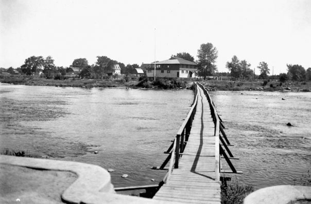
Historically residents of these two communities used to enjoy pedestrian access, near where the Ottawa Tennis Club is located, by way of a seasonal wooden footbridge that was reinstalled each year after spring floodwater passed and removed in the fall (see Document 2). With the loss of this seasonal bridge connection many decades ago general foot traffic has since either detoured to the north to Cummings Bridge (700 metres away) or to the south to the Hurdman pedestrian bridge (formerly a railway bridge) at Highway 417 (1.3 kilometres away). However in the summer time people do commonly walk barefoot across the Rideau River near Donald Street as the water level is shallow enough where it flows over a flat river-wide rock shelf that exists there.
The proposed crossing of the Rideau River is part of a pedestrian and cycling link that is shown in the Sandy Hill Secondary Plan, the Ottawa Cycling Plan and the Ottawa Pedestrian Plan.
This study will examine the feasibility of establishing a permanent river crossing, for both pedestrians and cyclists, between Overbrook/Vanier and Sandy Hill. This connection would be another city building project making Ottawa more walkable and cyclable.
DISCUSSION
The Statement of Work (SoW) for this Environmental Assessment (EA) project is described in Document 1. It outlines the tasks to be undertaken for Rideau River Multi-Use Crossing Between Donald Street and Somerset Street East – Environmental Assessment Study, including consultation, and upon approval from Transportation Committee will form the basis for a call for proposals to the consulting industry.
This project will be carried out
as a Schedule ‘C’ Class EA as set out in the Municipal Engineers Association’s
“Municipal Class Environmental Assessment” document. Since there may be a requirement for Federal
land (National Capital Commission), permits and funding, the project must also
comply with the requirements of the Canadian
Environmental Assessment Act (CEAA).
This project must satisfy both Provincial and Federal act requirements
through a co-ordinated process to avoid duplication of effort.
As part of the EA study the key
agencies of the Rideau Valley Conservation Authority and federal and provincial
departments responsible for waterways will be very involved given the potential
impacts on the Rideau River. There will
be involvement and consultation with the National Capital Commission, who own
the lands on the east side of the river, and with the Commission’s tenant, the
Rideau Tennis Club, whose use of both sides of the City’s Donald Street road
allowance for client parking may be impacted.
On the west side of the river is the City-owned Strathcona Park across
which access would be needed to reach this river crossing.
Study Timing
It is expected that it will take approximately 12 to 15 months after contract award to complete this study. This timeline is consistent with industry practice for projects of this scope and reflects the City’s experience.
ENVIRONMENTAL IMPLICATIONS
The study will examine and evaluate the project’s effects on social, physical and natural environments within the study area. Where needed, appropriate mitigation measures will be developed.
RURAL IMPLICATIONS
N/A
CONSULTATION
This study will involve stakeholders, including local community/interest groups, property owners, and approval agencies. Early in the study process, community stakeholders will be identified through liaison with the two Ward Councillors.
Consultation with the general public will occur principally through public meetings/open houses, but also through the project web page, e-mail and additional meetings as required.
COMMENTS BY THE WARD COUNCILLOR(S)
Ward 12 Councillor Georges has
commented that the University of Ottawa with its 33,000 students is
located in Sandy Hill. The Corktown
Bridge from Somerset East to Somerset West has allowed more flexibility for
students wishing to live near the university.
Additionally the Somerset Street East to Donald Street Bridge would
further expand the possibilities for accommodation for students and all the
residents who walk. The connection would also increase access to much needed
recreational space for both downtown communities.
Ward 13 Councillor Jacques Legendre states that this Environmental Assessment has his complete support. He also notes the following additional comments:
It is strange to reflect that over 60 years ago the needs of pedestrians and cyclists were better served than they are today. That our forefathers thought it important enough to establish, at least, a seasonal bridge is a testimony to a long-standing desire for such a link. Even today, the need for this essential connection is demonstrated every summer when people roll-up their pant legs and walk across this shallow area of the river.
A pedestrian/cyclist bridge at
this location may be even more needed today than it was in the past. Traffic on the bridges crossing the river and
on the major arterials leading to and away from these crossings has become so
intense that these corridors are now undesirable for pedestrians and
uncomfortable, even hostile, for cyclists (e.g. the east-bound direction on the
Cummings Bridge is especially so). This
link would establish a cycling friendly route from parts east of the river all
the way into the downtown via the newly built Corktown Bridge over the
canal. The link would also serve to
provide an improved connection to the NCC pathway system on both banks of the
Rideau River for all users.
LEGAL/RISK MANAGEMENT IMPLICATIONS
There are no legal/risk management impediments to implementing the recommendations in this report.
CITY STRATEGIC PLAN
This EA study is supportive of the following City Strategic Plan objectives:
§ A1 – Improve the City’s transportation network to afford ease of mobility, keep pace with growth, reduce congestion and work towards modal split targets,
§ D3 – Reduce greenhouse gas emissions by up to 20 per cent by 2021.
§ E6 – Require walking, transit and cycling oriented communities and employment centres.
TECHNICAL IMPLICATIONS
N/A
FINANCIAL IMPLICATIONS
Funds are available to undertake this feasibility study in budget item No. 905390 Pedestrian Missing Links Studies.
SUPPORTING DOCUMENTATION
Document 1 Statement of Work: Multi-Use Crossing of the Rideau River between Donald Street and Somerset Street East – Environmental Assessment Study
Document 2 Photo of former Rideau River footbridge looking east to Rideau Tennis Club
DISPOSITION
Following Committee approval of the attached Statement of Work, staff from the Planning and Growth Management Department will commence the consultant selection process with the assistance of Supply Management.
STATEMENT OF WORK: MULTI-USE
CROSSING OF THE RIDEAU
RIVER BETWEEN DONALD STREET AND SOMERSET STREET
EAST – ENVIRONMENTAL ASSESSMENT STUDY DOCUMENT 1
STATEMENT
OF WORK
MULTI-USE CROSSING OF THE RIDEAU RIVER BETWEEN
DONALD STREET AND SOMERSET STREET EAST – ENVIRONMENTAL ASSESSMENT STUDY
INTRODUCTION
The City of Ottawa is the proponent of an Environmental Assessment (EA) to study a potential multi-use crossing of the Rideau River between Donald Street and Somerset Street East. This bridge and connecting pathways would link the communities of Overbrook and Vanier with Sandy Hill. Additionally this proposed link would permit the creation of a new east-west cycling route that is an alternative to busy Montréal Road and Rideau Street.
This Statement of Work (SoW) describes the City’s intentions with respect to the methodology, public consultation and deliverables for this study. The SoW outlines the tasks to be undertaken to complete the EA study, and upon approval from the City’s Transportation Committee, will form the basis for a Request for Proposal (RFP).
BACKGROUND
Many decades ago, a movable wooden footbridge existed across the Rideau River in the vicinity of the current Rideau Tennis Club (at the end of Donald Street) providing a link between Overbrook and Sandy Hill. This bridge was dismantled every fall and then reinstalled in the spring after water levels fell. This seasonal pedestrian connection no longer exists and foot traffic from Overbrook must now detour north to the Cummings Bridge (700 metres away) or to the south to the Hurdman pedestrian/cycling bridge immediately south of Highway 417 (1.3 km away). Even though the footbridge was long ago removed each summer, when water levels are low, people do continue to cross the river by walking barefoot through the shallow water at the area where there is a flat underwater rock shelf that extends across the whole width of the riverbed.
A Rideau River pedestrian and cycling bridge connection in the area of Donald Street and Somerset Street East is part of the following Council approved policy documents:
- Sandy Hill Secondary Plan (1994) found in the current Official Plan - Volume 2A
- Ottawa Cycling Plan (2008)
- Ottawa Pedestrian Plan (2009)
Specific direction was given with approval of the Pedestrian Plan that staff undertake a study of the feasibility of a multi-use connection across the Rideau River at this location.
It is important to note that this connection across the Rideau River provides not only a link between the communities on the east and west banks of the river but it also would be a key link in a larger cycling/pedestrian network. This bridge and pathway would permit walkers and cyclists to head westward to connect with the Corktown Bridge over the Rideau Canal providing access to the downtown core. Moreover this new east-west connection provides a more secure route for cyclists who prefer not to use busy Rideau Street and Montréal Road.
LEGISLATIVE CONTEXT
As the City is the proponent for this undertaking, this project is subject to the Ontario Environmental Assessment Act (OEAA).
Federal EA requirements must also be addressed due to a potential requirement for use of federal (National Capital Commission) lands, permits and funding. All relevant environmental inventories and analysis undertaken for this assignment will be of sufficient scope to satisfy both federal and provincial EA requirements.
PROJECT DESCRIPTION
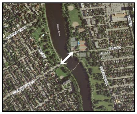
The multi-use connection crossing of the Rideau River will involve examination of potential crossing locations in the general area south of the Cummings Bridge and north of the Highway 417 Bridge (Figure 1); this including a focus on the centre area of Donald and Somerset Streets (Figure 2).
FIGURE 1- General Study Area
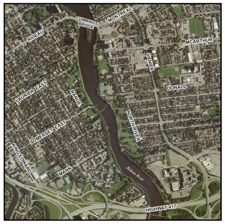
FIGURE 2- Portion of General Study Area
MAJOR ISSUES TO BE ADDRESSED
This study will determine how
best to design and integrate the preferred alignment and profile for the
multi-use connection, including:
q mitigation of effects on the flora/fauna of
the Rideau River from bridge pier(s) and river edge abutments
q addressing potential impacts on river flow, particularly at the periods of high water levels during annual winter ice damming, during spring ice break up activities by the City and regular/exceptional spring flood events
q examining, if the new bridge is located at the end of Donald Street, the loss of public parking spaces along Donald Street (used by clients of the Rideau Tennis Club) due to the need to create a sidewalk and cycling connection from North River Road
q examining impacts on Strathcona Park, be
it to the passive/active park areas, the parking lot and the historic river
wall walkway
q aesthetic considerations of the bridge design, especially given the historical context of parklands and facilities on both sides of the river
q multi-use crossing location options if, instead of Donald Street (at the tennis club), adjacent National Capital Commission (NCC) park property to the south is the recommended location for the connection to North River Road and Donald Street
q effects on the adjacent neighbouring residential communities
In addition, safety, aesthetic value, functional and security issues and emergency response will be investigated and addressed throughout the course of the study.
PROJECT SCOPE, TASKS AND DELIVERABLES
1.0 General
This project will be consistent with the approach and requirements set out in the provincial Environmental Assessment Act. Since there may be a requirement for federal land, permits and funding, the project must also comply with the requirements of the Canadian Environmental Assessment Act (CEAA). This project must satisfy both provincial and federal act requirements through a coordinated process to avoid duplication of effort.
1.1 Study Area
The EA study area is shown in Figure 1 being an area roughly bounded by Cummings Bridge on the north, Range Road on the west, Highway 417 Hurdman Bridge on the south and North River Road on the east. The study area could be modified accordingly to respond to new information and conditions as they emerge during the course of the study.
The study will establish the requirements of the connecting links for pedestrian and cycling access and identify any right-of-way requirements and easements for the crossing.
1.2 Timing
The study is expected to be completed within approximately 12 months of consultant selection.
1.3 Coordination with Other Studies
The EA Study process will take into consideration any information including analysis and findings of previous and concurrent transportation, development and infrastructure projects that could influence the direction and/or conclusions of the Study. Relevant background material will also be collected and reviewed, such as the rock and soil conditions found for the recently constructed new Rideau River deep sewer under North River Road 200 metres east of the river.
2.0 Environmental Assessment Study Tasks
The major study tasks are summarized as follows:
2.1 Project Need
This study will assess and evaluate the need to provide a multi-use pathway and bridge connection across the Rideau River between Overbrook and Sandy Hill. The key components of this stage include:
q Identifying and assessing future pedestrian and cyclist travel demand
q Documenting the benefits to users of these active transportation modes should this missing link crossing be constructed
This analysis will be used to identify all reasonable alternatives to the undertaking.
2.2 Environmental Inventory/Existing Conditions
An inventory of the social, economic, physical and natural environments within the study area will be compiled. The inventory will consider all available background material and where necessary, supplement this information through on-site surveys and/or detailed studies.
In general, the inventory will identify and describe those aspects of the environment that could potentially affect, or be affected by, the undertaking. Some of the specific aspects of the environment and existing conditions associated with this project include:
q effects on Rideau River’s fauna, flora, water flow, flood risk, spring ice blasting
q the impacts on passive and active parkland on lands bordering the river
q adjacent communities including Overbrook, Vanier and Sandy Hill
q current and future sidewalk, cycling and multi-use pathway corridors/routes
q current storm water drainage patterns
q subsurface (geotechnical) conditions
q utilities including water, sanitary, hydro, gas, cable, phone, fibre optic
q heritage and archaeological conditions
The inventory must be completed
for the entire study area so that as alternatives are developed and analyzed,
the cumulative effects can be examined.
The complete inventory will be clearly described and documented within
the final report.
2.3 Evaluation Criteria and Evaluation Process
A comprehensive list of
evaluation criteria and methodology will be developed and used to evaluate the
various alternative solutions and designs.
Refinements may be made to the evaluation process in order to accommodate
changing conditions or circumstances as they arise.
2.4 Alternative Solutions
Developing and examining a full range of options complies with the EA Act requirement that all reasonable alternatives to the undertaking be assessed. The alternatives will be analyzed and evaluated based upon various criteria and indicators to assess the impacts (with consideration to possible mitigation measures) on the environment and to recommend a preferred alternative solution.
The key components of this stage include:
q Identifying alternative solutions to address transportation problems. Examples include:
O Do nothing
O Provide
as a seasonal connection only
O undertake modifications to existing bridges
to the north and south to improve facilities and conditions for year round use
by cyclists and pedestrians
o
Provide a
new year-round multi-use crossing
q Analyzing and evaluating the alternative solutions and select the preferred alternative that best meet the needs
Alternative solutions will be
developed with input from the Consultation Groups and will be presented to the
public for comments.
2.5 Selection of Design Alternatives
Provided the preferred solution involves provisions of new pathway/bridge infrastructure, the various design alternatives will be identified and evaluated.
The pathway/bridge alignment and cross-section design alternatives will be identified based on consideration of constraints within the study area, input from the public, consultation groups and approval agencies, landowners, as well as City guidelines/standards/practices. All proposed designs will include any required modifications on crossing/connecting roadways, either public or private.
The alternative designs will be assessed and evaluated as to their affects on the natural, social, urban, economic and transportation environments. To ensure that all of the impacts are identified, the necessary investigations such as: noise, air quality, vibration, heritage and archaeological, natural areas and wildlife habitats, storm water management, geotechnical, traffic impacts, accessibility and safety, urban and landscape design, property impacts and any other research that would be required to properly define the effects of the facility will be carried out.
The alternatives will be compared to each other with the
ultimate goal of determining a recommended design. Following the evaluation of alternatives and
determining all necessary mitigation measures to minimize any adverse impacts,
a technically preferred design will be prepared and the results will be presented
at a final Public Meeting/Open House.
2.6 Recommended Plan
Upon receipt and
incorporation of public feedback, the recommended design will then be developed
to a sufficient level of detail as required to produce a functional design plan
that is adequate for submissions for project approvals in principle and to
establish a complete scope of work, baseline budget and implementation
schedules for the entire project. The
recommended plan will include but may not necessarily be limited to:
q A written description of the undertaking including the design parameters
q Functional design drawings (1:500 scale plan and profile) for the preferred alignment with a geo-referenced horizontal alignment, vertical alignment, grading drainage and property envelope, structural general arrangement drawings
q Cross-section drawings for typical sections as well as critical areas (e.g. river banks);
q Implementation (phasing) plan, if applicable
q Recommended mitigation measures to reduce the environmental impacts of the project
q Storm water management requirements
q Property needs
q Cost estimate of the proposed works (prepared in the WBS format with scope statements for each element) for budgeting/funding purposes
The Recommended
Plan will clearly identify and set out the requirements and timing for all
subsequent approvals required to proceed with the construction phase of the
project.
2.7 Environmental Assessment Report
The study findings and recommended design with mitigation plans will be presented to the Transportation Committee for approval. A Draft and Final Environmental Study Report (ESR) will be prepared to document the entire study process including the recommended design and any appropriate mitigation plans, amending procedure, costing, and implementation and Staging Plan, and commitments to future action, including external approvals known to be required.
The final ESR, incorporating all pertinent comments, will
be prepared and placed on public record for a minimum 30-day review
period. Reference copies of the report
will be made available at local libraries, universities and college libraries,
City Hall, City Client Service Centres and the MOE Regional and/or District
office.
2.8 Federal EA Project Description Report
Federal permits, property and funding may be sought before project implementation can proceed. In order to expedite the future federal approval processes, early discussions will take place with the relevant federal Responsible Authorities (RAs) to identify all federal EA requirements and initiate the federal EA screening process. This will ensure that all relevant existing environmental inventory data collected and impact assessments carried out during this assignment are scoped sufficiently to address federal EA screening requirements.
A federal Project Description Report will be prepared,
containing a written description and general arrangement drawings for the
project in accordance with the requirements of the federal RAs. The report will
include enough information on potential impacts, mitigation measures and
conceptual compensation strategies to allow the federal agencies to conclude on
the significance of environmental effects at this early planning stage.
3.0 Consultation
This study will involve a number of stakeholders, including community groups, property owners, businesses, institutions, approval agencies and special interest groups. Early in the study process stakeholders will be identified. This will be accomplished through various forms of consultation, including liaison with City Councillors, community associations, approval agencies and public notification.
The consultation program will primarily consist of meetings with stakeholders, individually and through Consultation Groups, and Public Meetings with the general public. Consultation Groups will meet with the Study Team at key stages to review and comment on specific issues, the study progress and findings. Two consultation groups will be established, namely, a Public Consultation Group (PCG) and an Agency Consultation Group (ACG). The membership, roles and responsibilities of each Consultation Group will be outlined and communicated to each prior to meetings taking place.
Specific aspects of the consultation program are detailed as follows.
3.1 Public Consultation Group
A Public Consultation Group (PCG) will be formed to enable
community/special interest groups and adjacent property owners to provide
direct input to the study, advising and commenting on local issues and
concerns. Membership of this group will
be determined in consultation with affected ward councillors.
3.2 Agency Consultation Group
An Agency Consultation Group (ACG) will be formed to
address the full range of technical and policy issues and to comment on all of
the special studies required to fully assess the various alternatives and to
ensure that the City is following the procedures, legislation and addressing
appropriate policies. ACG members will
include experts in their related fields from government agencies and approval
bodies.
3.3 Notifications
The public will be notified of: the Study commencement, all Public Meetings/Open Houses and the filing of the ESR (Notice of Completion). Notifications will be sent out at appropriate stages in the Study, and each announcement will take the following forms:
q Advertisements in daily newspapers (The Ottawa Citizen, Le Droit)
q Advertisements in community papers, where appropriate
q The project web site on the City’s web portal
Additional notifications will be undertaken, as required, in accordance with provincial EA regulations.
3.4 Public Open Houses
A minimum of two Public Open Houses will be held to present and obtain feedback on existing conditions and alternatives to the undertaking, the preferred solution and alternative design concepts, and the recommended plan.
Background and presentation material will include a
“Project Update Newsletter” which summarizes the information presented at the
public meetings and will be available for general distribution. Bilingual staff will be present during all
public meetings and all material presented at the meetings as well as the
“Project Update Newsletter” will be bilingual.
3.5 Project Web Page
A Project Information Web Page for the Study will be established on the City’s external web site. The purpose of the Web Page will be to inform the public of the progress of the study and upcoming meetings or activities, post the bilingual materials presented at each Public Meeting/Open House and provide a point of contact for e-mail correspondence.
3.6 Deliverables
The deliverables for the study include:
q Public Meetings/Open House Summary Reports – one for each public meeting
q Project Web Page data – as required
q Project Update Newsletter – one for each public meeting/open house
q Functional design drawings of the preferred design, including plans and profiles for recommended alignments, and elevation drawings, structural general arrangement drawings, utility relocation details, storm water management plans, landscape design plans, and property requirement plans
q Project Implementation/Staging Plan, which will identify all future approval requirements including those for property acquisitions and easements and other property related matters
q Project capital and maintenance costs in WBS format
q Approvals in principal as required by regulatory agencies
q Draft and Final Environmental Assessment Study Report (ESR)