Report to / Rapport au :
Transit Committee
Comité du transport en commun
16
March 2010 / 16 mars 2010
Submitted by / Soumis par: Nancy Schepers,
Deputy City Manager/Directrice municipale adjointe,
Infrastructure Services and
Community Sustainability/Services d’infrastructure et Viabilité des
collectivités
Contact Person / Personne ressource
: Vivi Chi, Manager/Gestionnaire, Transportation
Planning/Planification des transports, Planning and Growth Management/Urbanisme
et Gestion de la croissance
(613) 580-2424 x21877,
vivi.chi@ottawa.ca
|
|
Ref N°: ACS2009-ICS-PGM-0046
|
|
SUBJECT:
|
Rideau Canal multi-use
crossing near CleGg Street and Fifth Avenue:
Environmental Assessment Study - Statement of Work
|
|
|
|
|
OBJET :
|
PASSERELLE POLYVALENTE SUR LE CANAL RIDEAU PRÈS DE LA RUE CLEGG ET DE
L’AVENUE FIFTH : ÉVALUATION ENVIRONNEMENTALE - éNONCé DE TRAVAIL
|
REPORT
RECOMMENDATION
That Transportation Committee approve the Statement of
Work for the Rideau Canal Multi-use Crossing near Clegg
Street and Fifth Avenue: Environmental Assessment Study as
detailed in Document 1.
RECOMMANDATION
DU RAPPORT
Que le
Comité des transports approuve l’énoncé de travail de l’évaluation
environnementale relative à la passerelle polyvalente du canal Rideau près
de la rue Clegg et de l’avenue Fifth, décrite dans le document 1.
BACKGROUND
The origins of a Rideau Canal
crossing near Clegg Street and Fifth Avenue dates back
to the Holt Plan (1915); the Greber Plan (1950); and National Capital
Commission plans (1968). A ferry
operated for several decades in this vicinity until circa 1950. Through the 1950s and 1960s the National
Capital Commission (NCC) annually constructed a wooden footbridge in the winter
months between Herridge Street and Second Avenue. With the loss of these seasonal crossings,
pedestrians and cyclists have had to detour to either the Pretoria Bridge (850
metres north) or the Bank Street Bridge (1.25 kilometres south).
In recognizing the need for
greater community connectivity between the Glebe and Old Ottawa East/South, a
Canal crossing at Clegg Street and Fifth Avenue has been added to the Ottawa
Cycling Plan (2008), the Ottawa Pedestrian Plan (2009) and the Draft Old Ottawa
East Community Design Plan (2009). In
June 2009, Council directed staff to include sufficient funds for an
Environmental Assessment of the Clegg/Fifth Avenue
footbridge in the 2010 budget as part of the Ottawa Pedestrian Plan
approval process.
The Official Plan, Transportation
Master Plan and the City Strategic Plan all support sustainable and active
transportation solutions with an emphasis on connecting communities and
increasing intensification inside the greenbelt.
In November 2009, Council
directed that an international design competition be undertaken for a new urban
park for the Lansdowne Revitalization.
This design competition has been initiated in partnership with the NCC
and Parks Canada. The Request For Proposal (RFP) was released to five design teams invited
to submit design proposals for this urban park.
The RFP contains the option for the design teams to include a pedestrian
bridge connection between the Glebe and Old Ottawa East/South in the vicinity
of Lansdowne. This was left open as an
option in the RFP in recognition of the significant benefits that such a
connection could provide to both the communities and for the Lansdowne
Revitalization project.
A Clegg/Fifth Avenue footbridge
would connect the communities of the Glebe, Old Ottawa East and Old Ottawa
South in a way that is more direct and safe than existing conditions. It will also promote healthy active
transportation and will help to reduce road congestion and harmful greenhouse
gas emissions. A preliminary scan of
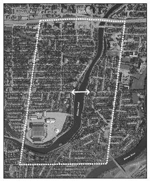
land uses on both sides of the Canal within the Study Area (Figure 1 in Document
1) suggests that a new bridge in this vicinity would provide numerous benefits
for area schools (such as: Lady Evelyn,
Immaculata, St. Paul’s University, First Avenue, Corpus Christi, Muchmor),
businesses, and residents alike.
Following the success of the recent Rideau Canal Corktown Footbridge, a
new crossing of the Rideau Canal near Clegg Street and Fifth Avenue is expected
to achieve comparable results.
Prior to initiating the consultant selection process for the
Environmental Assessment, staff require approval from
Committee on the scope of the work for the Study.
DISCUSSION
The Statement of Work (SoW) is
described in Document 1. It outlines the
tasks to be undertaken for the Rideau Canal Multi-use Crossing near Clegg
Street and Fifth Avenue: Environmental Assessment Study, including
consultation, and upon approval from Transportation Committee will form the
basis for a call for proposals to the consulting industry.
This project will be carried out as a Schedule ‘C’ Class Environmental
Assessment (EA) as set out in the Municipal Engineers Association: “Municipal
Class Environmental Assessment” document.
The EA study area will primarily
encompass the Rideau Canal between Pretoria Avenue and Bank Street including
the lands approximately 500 metres to the east and west, as shown in Document 1
(Figure 1). However,
some study tasks will require examination of a broader area, beyond these
limits in order to address environmental impacts and operational issues; to coordinate
with relevant completed or on-going studies and projects (Old Ottawa East
Community Design Plan, Ottawa Cycling Plan, Ottawa Pedestrian Plan, Lansdowne
Revitalization, etc.) and to study and identify tie-ins to future network
connections including drainage and environmental influences.
Key objectives for the study include the following:
·
To assess the need for a new pedestrian and
cycling crossing;
·
To define the design guidelines/parameters, and
aesthetic criteria;
·
To examine potential crossing locations and
their impacts on the surrounding areas;
·
To determine a recommended location for the
crossing;
·
To produce a functional design for the
recommended crossing;
·
To establish mitigation measures, where
required;
·
To establish a cost estimate for the total
project (for budgetary and funding purposes);
·
To provide recommendations on the pursuance of
the project;
·
To establish the project approvals processes.
Potential Issues
Due to the recognition of the
Rideau Canal as a UNESCO World Heritage Site and a
National Historic Site, it is expected that there will be significant interests
from various stakeholders (NCC, Parks Canada).
Both the NCC and Parks Canada, through the Lansdowne Urban Park Design
Competition RFP have indicated support of pursuing such a connection, which in
addition to satisfying Provincial EA requirements will also need to satisfy Federal
EA Act requirements. Also, it would be
subject to additional processes to ensure the integrity of the Rideau Canal
system as a World Heritage Site.
A Clegg/Fifth Avenue footbridge has the potential of
increasing on-street parking demand in the communities of Old Ottawa
East/South, particularly when special events occur at Lansdowne Park.
·
Intersection control
The intersections of Queen
Elizabeth Drive/Fifth Avenue and Colonel By
Drive/Clegg Street may require intersection control measures to allow users of
the new footbridge to safely cross the Driveways.
STUDY TIMING
It is expected that
it will take approximately 24 months after contract award to complete this
study. This timeline is consistent with
industry practice for projects of this scope and takes into account the City’s
experience gained with the planning of the Corktown Footbridge.
ENVIRONMENTAL IMPLICATIONS
The study will examine and
evaluate the project’s effects on social, physical and natural environments
within the study area. Appropriate
mitigation measures will be developed and post mitigation environmental impacts
will also be determined.
RURAL
IMPLICATIONS
N/A
CONSULTATION
The study will involve stakeholders, including local
community/interest groups, property owners, businesses, area schools and
approval agencies. Early in the study
process, community stakeholders will be identified through liaison with the
Ward Councillor.
Consultation with the general public will occur
principally through public meetings, but also through the project web page,
e-mail and additional meetings as required.
It should be noted that a community-based advocacy
group called the Midtown Footbridge Group has been established and has been
organizing and documenting support for this project over the last two
years.
COMMENTS BY THE WARD COUNCILLOR
Councillor Doucet states that there has been
local enthusiasm for a pedestrian/cyclist connection across the Rideau
Canal in the vicinity of Fifth Avenue for many years. The Community
Associations directly affected by this proposed bridge (Old Ottawa East, Old
Ottawa South and the Glebe) have all passed resolutions in favour of a
pedestrian/cyclist connection.
The Pretoria and Bank St. bridges are separated by a
kilometre. A pedestrian bridge in the vicinity of Fifth and Clegg would
reduce the walk time from 30 or 45 minutes to between 5 and
15 minutes depending on the origin and destination of the trip.
The great advantage this proposed bridge creates for pedestrian
movement can be imagined when one considers the Somerset pedestrian bridge
is only 400 meters from the Laurier St. bridge,
yet it carries about 3,000 pedestrians a day.
The nearest bridge to the proposed pedestrian bridge is about half a
kilometre.
The proposed bridge will reduce automobile use, create a busier pedestrian and cycling
environment and safer, more lively community streets by increasing
pedestrian and cycling use for all ages.
LEGAL/RISK MANAGEMENT IMPLICATIONS:
There are no legal/risk management impediments to implementing the
recommendations in this report.
The
recommendations contained herein directly supports the following objectives of
the City Strategic Plan adopted by Council on 11 July 2007:
A1 Improve the City’s
transportation network to afford ease of mobility, keep pace with growth,
reduce congestion and work towards modal split targets
D3 Reduce greenhouse gas
emissions by up to 20 per cent by 2012
E6 Require walking, transit and cycling
oriented communities and employment centres
TECHNICAL IMPLICATIONS
N/A
FINANCIAL IMPLICATIONS
Funds
are available to undertake this Study in account 905390 (Pedestrian Missing
Links Studies).
SUPPORTING DOCUMENTATION
Document 1 Rideau Canal Multi-use Crossing near Clegg
Street and Fifth Avenue: Environmental Assessment Study – Statement of Work
DISPOSITION
Following Committee approval of the attached Statement
of Work, staff from the Planning and Growth Management Department will commence
the consultant selection process with the assistance of the Supply
Management.
RIDEAU CANAL MULTI-USE CROSSING NEAR CLEGG
STREET
AND FIFTH AVENUE: ENVIRONMENTAL ASSESSMENT STUDY –
STATEMENT OF WORK DOCUMENT 1
City
of Ottawa
Rideau
Canal Multi-use Crossing near Clegg Street and Fifth Avenue:
Environmental
Assessment Study
STATEMENT OF WORK
1.
INTRODUCTION
The City of Ottawa is initiating
an Environmental Assessment (EA) Study for a new pedestrian and cycling
crossing over the Rideau Canal. This
crossing would connect the west side of the Canal, in the vicinity of Fifth
Avenue, to the east side of the canal in the vicinity of Clegg Street, as shown
in Figure 1. The City will work together
with the National Capital Commission (NCC) and Parks Canada to determine the
most suitable crossing design.
This Statement of Work (SoW) describes the City’s intentions with
respect to the methodology, public consultation and deliverables for this study
and will form the basis for a Request for Proposal for consultant services –
upon approval from Transportation Committee.
FIGURE 1-
General Study Area
As the City is the proponent for
this undertaking, this project is subject to the Ontario Environmental Assess
Act (OEAA). Federal EA requirements must
also be addressed due to a potential requirement for use of federal lands,
permits and funding. All relevant
environmental inventories and analysis undertaken for this assignment will be
of sufficient scope to satisfy both federal and provincial EA requirements.
2.
PROJECT OBJECTIVES
The following are the objectives
of the Project:
·
To assess the need for a new pedestrian and
cycling crossing;
·
To define the design guidelines/parameters, and
aesthetic criteria;
·
To examine potential crossing locations and
their impacts on the surrounding areas;
·
To determine a recommended location for the
crossing;
·
To produce a functional design for the
recommended crossing;
·
To establish mitigation measures, where
required;
·
To establish a cost estimate for the total
project (for budgetary and funding purposes);
·
To provide recommendations on the pursuance of
the project;
·
To establish the project approvals processes.
3.
SCOPE
OF WORK
The Project will
proceed in stages to achieve the stated objectives. The sequential components include: Study Design; Environmental Assessment
(provincial and federal); and Project Costs and Schedule.
3.1
Study Design
At the start of the study, a Study Design
will be developed which will identify, in detail, the key components and
activities of the project and expected deliverables. This Study Design will
identify and clarify what the main issues are, how they might be addressed, and
how project resources might be spent most effectively.
The Study Design
will be used to guide the Project. As a
minimum, it will include:
·
A project organization chart including roles and
responsibilities of partner organizations;
·
The methodology for conducting the study,
including design and aesthetic criteria;
·
The public/stakeholder consultation strategy;
·
Study schedule including the identification of
decision and approval milestones;
·
Approval process/flowchart (from start of Study
to the finalization of detail design and commencement of construction).
The design and aesthetic criteria component of the
Study will include, but not be limited to, the following tasks:
· Identify
the user groups who will use this facility, and their specific design
requirements;
· Scope
the potential issues associated with the proposed connection on the Rideau
Canal Management Plan and as a UNESCO World Heritage Site and identify possible
mitigation measures that may have to be undertaken to ensure compatibility;
· Determine
the NCC’s and Parks Canada’s maximum permissible impact envelope of the
proposed structure on the vistas, views, and cones of vision from the
appropriate locations within the Rideau Canal corridor;
· Develop
the design parameters and criteria for the Canal crossing, the landing on both
sides of the Canal, and the connections to the Queen Elizabeth Driveway,
Colonel By Drive and the Canal corridor pathway systems;
· Determine
the appropriate dimensions for the crossing elements;
· Define
the location and alignment parameters for the proposed crossing, including the
east and west landing locations;
· Establish
the desirable or minimum aesthetic parameters that will address the NCC’s and
Parks Canada’s concerns;
· Develop,
in general terms, the criteria and appearance of the Crossing materials, including
the treatment of the landing areas and connections to Queen Elizabeth Driveway
and Colonel By Drive;
· Identify
all of the conditions and restrictions associated with the construction and
operation of the proposed pedestrian bridge across the Rideau Canal, including
the impacts on the Canal operations as a navigable waterway;
·
Identify all jurisdictional, operational, and
maintenance associated responsibilities for the proposed pedestrian connection;
· Assess
any pedestrian bridge crossing proposals/designs that may be submitted by the
winning design team for the Lansdowne urban park design competition to
determine how the proposal could respond to the requirements determined through
the EA.
3.2
Environmental Assessment Study
The environmental assessment is
initiated following the completion of the Project Planning stage. This undertaking will comply with both
federal and provincial EA regulations.
The EA must include:
·
Confirmation of need for a new pedestrian and
cycling crossing of the Canal;
·
Inventory and analysis of existing conditions
(social, economic, physical, natural environments);
·
Development of crossing locations options;
·
Development of evaluation criteria for assessing
crossing locations options;
·
Development of a comprehensive evaluation process
for assessment;
·
Evaluation and selection of the preferred
crossing location;
·
Development of alternative designs for the
preferred crossing location;
·
Development of evaluation criteria for assessing
the alternative designs;
·
Development of a comprehensive evaluation
process for the assessment of the alternative designs;
·
Evaluation and selection of the preferred
design;
·
Assessment of operational and maintenance
matters;
·
Development of a functional design for the
recommended Crossing; and
·
Development of a mitigation plan.
The EA will
assess all effects (and cumulative impacts) that this project may have on the
environments. It will investigate
stormwater management issues, undertake geotechnical studies, develop
landscaping and lighting plans, and identify all property requirements
(including encroachments, leases and licensing requirements). Comprehensive consultation with the public,
stakeholders, and government agencies will take place throughout the course of
this study.
The Study findings and recommended design with
mitigation plans will be presented to Transportation Committee for approval.
The
Environmental Study Report (ESR) will be prepared to document the entire study
process including the recommended design, mitigation plans, implementation
and staging plan, EA amending procedure, commitments to future action and
including external approvals known to be required. This ESR will be placed on the public record
for a 30-day review period. Copies of
the ESR will be made available for public viewing at local public libraries,
university and college libraries, City Hall, Client Service Centres and the MOE
Regional and/or District Office.
A federal
Project Description Report will be prepared in accordance with the requirements
of the federal Responsible Authorities.
The report will include enough information on potential impacts,
mitigation measures and conceptual compensation strategies to allow the federal
agencies to conclude on the significance of environmental effects at this early
planning stage.
3.3
Project Cost and Schedule
A cost estimate for the Crossing
based on the preferred design will be developed for budgetary and funding
purposes. A Work Breakdown Structure
(WBS) format will be used for scoping and costing of the project elements such
as property, construction, detailed design, project management, construction
supervision, contingencies, and escalation.
A preliminary construction-sequencing schedule will
also be developed.
4. CONSULTATION
A detailed consultation program will be developed as
part of the Study Design. Similar to
other major EA studies, a Public Consultation Group and an Agency Consultation
Group will be formed to enable meaningful consultation with stakeholders at key
stages in the study. A minimum of three
Public Meetings/Open Houses with the general public will augment the
Consultation Group meetings.
Presentations to the NCC’s Advisory Committee on Planning, Design, and
Realty will also be required.
Notification of Study Commencement, public
meetings/open houses and filing of the ESR (Notice of Completion) will be
advertised in the daily newspapers, and community papers where appropriate, and
on the project website. The project
website will also be updated with information as the study progresses,
including display board information from the public open houses. Project Update Newsletters will be made
available at the open houses and on the website. Consultation summary reports will also be
compiled following each public meeting/open house event.
5. DELIVERABLES
The deliverables of this study include:
·
Public Meetings/Open House Summary Reports;
·
Project Web Page data – as required;
·
Project Update Newsletters – for distribution at Public Meetings/Open
Houses;
·
Functional design drawings of the preferred crossing (including plans,
profiles, structural general arrangement drawings, utility relocation details,
stormwater management plans, landscape and lighting design plans, property
requirement plans);
·
Project implementation/staging plan, which will identify all future approval
requirements (such as those for federal land acquisitions, easements, and
permits);
·
Project capital and maintenance costs in WBS format;
·
Approvals in principal as required by regulatory agencies; and
·
The Environmental Study Report (ESR).