Report
to/Rapport au :
Comité des transports
and Council / et au Conseil
16 November 2011 / le 16 novembre 2011
Submitted by/Soumis
par : Nancy Schepers, Deputy City
Manager, Directrice municipale adjointe, Infrastructure
Services and Community Sustainability, Services d'infrastructure et Viabilité des
collectivités
Contact
Person / Personne ressource : Vivi Chi,
Manager/Gestionnaire, Transportation Planning/Planification des transports,
Planning and Growth Management/Urbanisme et Gestion
de la croissance
(613) 580-2424 x21877, vivi.chi@ottawa.ca
REPORT RECOMMENDATION
That the Transportation Committee recommend Council:
1.
Approve the
Environmental Assessment study's recommended plan for the multi-use pathway
crossing of the Rideau River between Somerset Street East and Donald Street as
described in this report and in Document 5; and
2.
Direct staff
to finalize the Environmental Study Report for the Rideau River Multi‑Use Pathway Crossing project and post the
Notice of Study Completion.
RECOMMANDATION DU
RAPPORT
Que le Comité des transports recommande au Conseil:
1.
d'approuver le plan
pour un sentier polyvalent traversant la Rivière Rideau entre la rue Somerset
Est et la rue Donald, recommandé par l'étude d'évaluation environnementale et tel que décrit dans le document 5;
2.
d’enjoindre au
personnel d’achever le rapport d'étude environnementale concernant un sentier
polyvalent traversant la Rivière Rideau et d’afficher l'avis d'achèvement
d'étude.
BACKGROUND
In April 2010, Transportation Committee approved the Statement of Work for the preparation of an Environmental Assessment (EA) study for a multi-use (pedestrian and cycling) crossing of the Rideau River to better link Overbrook and Vanier with Sandy Hill and the downtown. The EA study would examine the feasibility of establishing a new all-season river crossing for pedestrians and cyclists. This connection is another City-building project that would make Ottawa more walking and cycling-friendly.
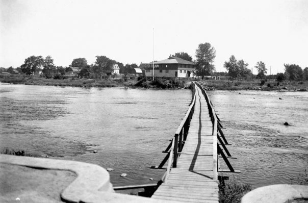
Historically, a seasonal wooden footbridge located between the west riverbank in Strathcona Park and the east riverbank near the Rideau Tennis Club on Donald Street was used to connect these communities (Document 1). This temporary bridge was reinstalled each year after the spring floodwater receded and it was removed in the fall. Some decades ago the seasonal bridge was discontinued forcing pedestrians to either detour:
· north to the Cummings Bridge (700 metres away) at Montréal Road and Rideau Street, which lacks a cycle lane in the eastbound direction and is subject to heavy volumes and speed of car and bus traffic, or,
· south to the Hurdman pedestrian bridge (formerly a railway bridge) at Highway 417 (1.3 km away). However there is no night lighting on the bridge and there is no winter snow clearance and lighting on the multi-use pathway that leads to the bridge from North River Road (Overbrook). In addition, the pedestrian bridge is in a location isolated from activities/buildings, resulting in a concern for personal safety.
Notwithstanding the loss of the old footbridge connection, in the summer time people regularly walk barefoot across the Rideau River near Donald Street, when the water level is shallow enough, where it flows over a wide flat river-wide rock shelf at the small waterfalls. During very cold winters, people also cross over the ice of the frozen river in areas further upstream and downstream of the open water area at the small waterfalls.
DISCUSSION
The EA study has followed the Municipal Class EA (Schedule C) process starting with problem identification, determination of the need and justification for the project, and data gathering and inventories of existing conditions.
A potential crossing of the Rideau River between Overbrook and Sandy Hill is included in the Official Plan, Sandy Hill Secondary Plan, and the Ottawa Pedestrian Plan.
Travel Characteristics
Travel characteristics of pedestrians and cyclists were reviewed using screenline counts (2008‑2010) at the Cummings Bridge and the mode share of travel (2005 Origin-Destination study) for the larger communities on the east and west sides of the river. The study area’s mode share is 2% cycling and 22% pedestrians as compared to the city-wide target for 2031 from the Transportation Master Plan of 3% cycling and 10% walking. While the City does not have targets for individual communities, it is understood that the cycling and pedestrian mode shares for the study area should be higher than the city-wide averages in order for the City to meet the overall goals given that the study area is part of the more urbanized core where travel distance are shorter and the roads have a grid pattern with sidewalks.
Alternative Solutions
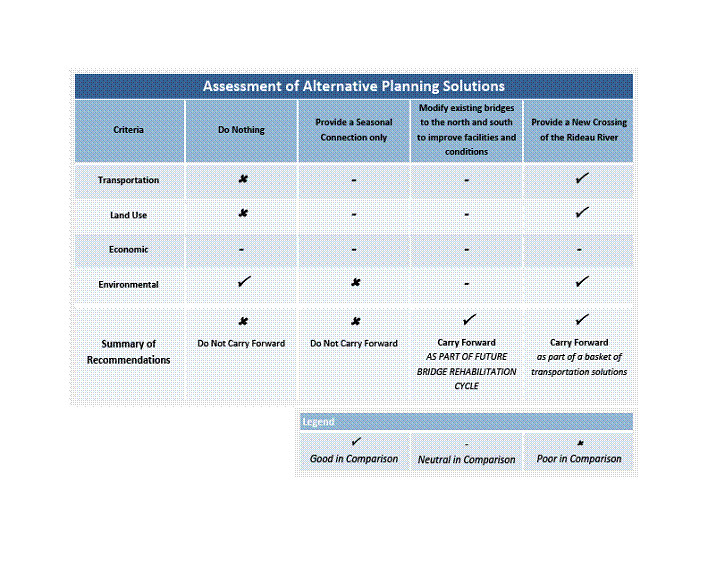
An alternative planning solutions and coarse screening exercise was undertaken as the next phase of the EA study. The alternatives examined included:
- do nothing;
- provide a seasonal connection only;
- modify existing bridges to the north and south to improve facilities for pedestrians and cyclists; and
- provide a new crossing of the Rideau River.
An analysis of these alternatives based on criteria for transportation (connectivity deficiencies, year round versus seasonal use, etc.), land use (Ottawa Cycling Plan, Ottawa Pedestrian Plan, park accessibility, Sandy Hill Secondary Plan, etc.), economic (capital and maintenance costs, societal risks to pedestrians and cyclists on existing bridges) and environmental (decrease green house gas, impact on river natural environment, heritage and archaeology impacts, etc.) resulted in a recommendation to carry forward the alternative of a new river crossing (Document 2). A similar evaluation was undertaken to assess underpass (tunnel) or overpass (bridge) options, with the bridge alternative being recommended as more suitable.
Alternative Crossing Locations
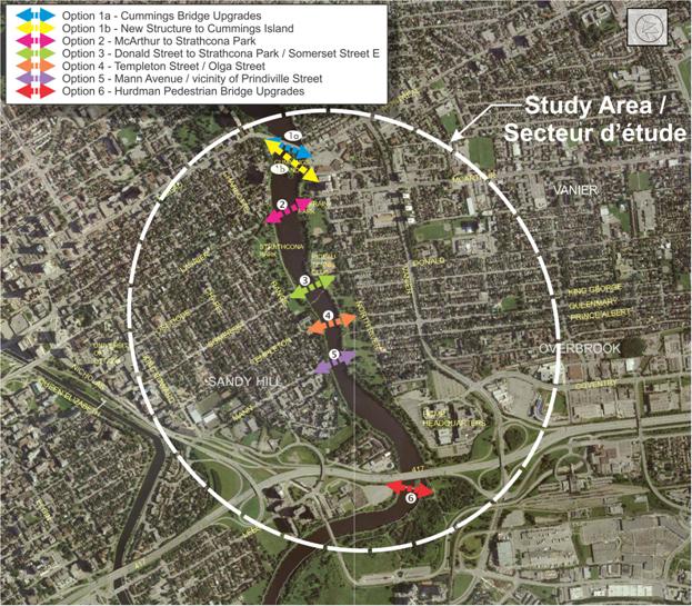
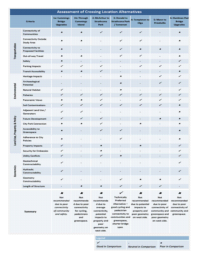
Seven alternative crossing locations were analysed, including, for comparison purposes, the Cummings Bridge and the converted railway bridge at Highway 417. Document 3 shows these seven locations which were examined using 25 criteria under the following subject areas: transportation; environment; land use, property and policy; economics; and, constructability. The evaluation of the alternative locations is included as Document 4. The evaluation concluded that a Somerset Street East to Donald Street crossing be carried forward as the recommended location. For this location, a number of technically preferred alternatives were developed and an analysis was done of the following possible pathway/bridge location options:
East side of the river:
- within the Donald Street road allowance; and
- south of the tennis courts on the south side of Donald Street.
Crossing the river:
- one location 50 metres south of the small falls; and
- four locations within 25 to 90 metres north of the small waterfalls.
West side of the river:
· two options through the middle of the existing parking lot, one with bollards, one without;
· one option splitting the path on each side of the parking lot;
· moving the parking lot to the south and locating the pathway where the parking lot was; and
· removing the parking lot and providing on-street parking on the east side of Range Road.
The technically preferred alternative recommended was the option of splitting the pathway north and south of the parking lot in Strathcona Park, crossing the river north of the small waterfalls, and carrying on along the Donald Street road allowance. The City owns the Strathcona Park lands on the west side of the River. The river bed is owned by the Province of Ontario through the Ministry of Natural Resources. The east side of the river is owned by the National Capital Commission (NCC) except for the 20 m Donald Street Road allowance which is City owned.
Based on input from the EA’s Agency Consultation Group, Public Consultation Group and the general public, further refinements were made to the technically preferred alternative, resulting in the proposed Recommended Plan. The main revisions were:
- simplification with one pathway only on the south side of the Strathcona Park parking lot;
- changing the slope of the bridge from 3% to 4.5% resulting in lower arrival heights of about half a metre (0.5 m and 0.7 m) at the pathways on the west and east sides so the rise and slope needed is less intrusive on the landscape;
- by slightly angling the bridge from the Strathcona Park shore the impact of the raised pathway approach is removed further from the viewscape of the historic northern part of the Park; and
- continuing the pathway directly along Donald Street on the south side to provide a full pedestrian and cycling connection to the intersection at North River Road.
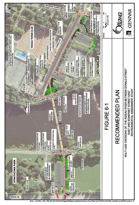
The Recommended Plan
The Recommended Plan proposes a 112 metre long truss bridge that would cross the river linking Somerset Street East with Donald Street with pathway connections on the east and west sides (Document 5). The bridge and pathways would be lit, snow cleared in the winter and fully accessible. As detailed on the Plan and summarized below, the project has three sections.
1) West side – Somerset Street East to the river pathway- At the Somerset Street East and Range Road intersection, a new 3 m wide multi-use pathway would be constructed along the south side of the parking lot leading to the new bridge. Light fixtures along it would be of a similar heritage design as is found along the river bank wall and promenade. At the Range Road intersection cyclist traveling west would enter the access aisle to the parking lot so to be able to properly cross the street intersection on the correct (north) side. To emphasis increased east-west pedestrian traffic crossing at Range Road, improved line painting at the intersection is proposed.
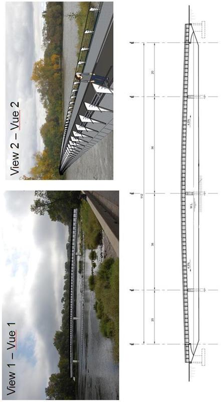
2) River crossing - The bridge abutments are to be located outside of the water’s edge to avoid damage to fish habitat. The bridge would be of a metal truss design with a concrete floor, a 4 m width and three piers in the water to span the river. The bridge height would provide for a 3 m clearance from the high-water mark which is needed to ensure room for river ice breaking in the spring. The bridge would not be covered. Document 6 provides a conceptual drawing and cross section of what the bridge might look like.
3) East side – river to Donald Street and North River Road - The bridge would cross the river with the approach on NCC parklands for about 30 m before the pathway arrives on the City’s Donald Street Road allowance. This new multi-use pathway would be constructed on the south side of the road all the way to North River Road. This would require removal of approximately 29 unmarked on-street parking on the south side (12 angled, 17 parallel) and a change from angled to parallel parking on the north side. At the North River and Donald Street intersection the pedestrian street crossing would be modified to add paverstones for the new cross walks such as is already found on the east side of the intersection.
Main Issues Raised During Consultation
The loss of parking spaces along Donald Street has generated the most concern. Currently, there is parking on the north and south sides of Donald Street which is used by both the Rideau Tennis Club clientele and federal employees from Place Vanier at McArthur and North River Road. The Recommended Plan would remove the south side parking and replace it with a multi-use pathway and the north side would change from angled to parallel parking. There is not sufficient available space within the road allowance to have both parking and the pathway on the south side, given the space occupied by trees along the southern edge (while most of these trees are dying and will be lost due to the emerald ash borer, replanting would be undertaken by Forestry Services likely at the same time or immediately post this project’s implementation). A parking survey was undertaken which indicated that highest usage is during weekdays with an average of 50 parking spaces occupied when counting both the Donald Street spaces and the two private tennis club off-street parking lots on the south side. Recognizing this, in addition to the Plan providing 55 spaces (18 on-street on the north side of Donald, 37-off street in the two Rideau Tennis Club parking lots), as mitigation for loss of street parking along Donald Street, the repaving of the NCC (Rideau Tennis Club) existing parking lots is also being proposed. The Strathcona Park parking lot will be reconfigured on the south side and also resurfaced.
Concerns for the potential loss of trees (and replacement plantings) and intrusion into the viewscape of Strathcona Park are addressed in the Recommended Plan by modifying the alignment. Other public comments expressed related to questions on the design (piers, lighting, that it be aesthetically pleasing) and the maintenance of the bridge (salt/sand impacting the aquatic environment). There was also concern with cars exiting the two parking lots on the south side of Donald Street crossing/conflicting with the safety of pathway users. The EA is recommending that the surface and design of the pathway carries on across the entrances; thus it will be one of visual features, on the ground and by signage, that the parking lot entrances are crossing the pathway not the reverse.
Preliminary Cost Estimate
The estimated preliminary cost for this project is $7 million in 2011 dollars. This includes design, construction of the bridge, pathway, parking lot repaving, road works and project administration. These initial cost estimates have been reviewed by staff in the Infrastructure Service Department, who would be responsible for detailed design and construction. Additional funding would be needed for the purchase, lease or land swap for about 500 m2 of NCC land on the east river bank that would be needed to link to the City’s Donald Street road allowance. Operating costs associated with the maintenance of these facilities would include approximately $6,000 annually for snow clearance for the bridge and pathway, summer operations of $3,000 for activities such as the 14-day grass cutting cycle, asphalt repairs, drainage and brush trimming and approximately $1,200 annually for lighting depending on light fixture design.
The Public Works Department was consulted in the development of this report and is supportive of the report recommendations. Subject to approval by Council, Public Works will continue to work with the Planning and Growth Management Department to implement the report recommendations.
Mitigation and Opportunities
Document 7 shows the preliminary impact and mitigation measures associated with the Recommended Plan. It also includes a listing of other opportunities that could be followed up for possible implementation but are not strictly part of the Plan and are not included in the current project cost estimate. An example is riverbanks improvements on the west bank at the small falls similar to the large stone step erosion control feature installed on the east side. The feasibility for coordination with the bridge construction and the cost to carry out these additional work items could be addressed at time of detailed design.
RURAL IMPLICATIONS
N/A
CONSULTATION
The consultation program for this EA involved:
- three Public Open Houses (POH), highlights of which are found in Document 8, during which there was considerable public support expressed for this new river crossing;
- several meetings of both a Public Working Group (PWG) and an Agency Consultation Group (ACG); the PWG included residents, representatives from local community associations and members of two City advisory committees; and the ACG included staff from the City, NCC, Rideau Valley Conservation Authority and the Ministry of Natural Resources;
- an initial meeting with the NCC (with a resultant clarification that a presentation to the NCC’s Advisory Committee on Planning, Design and Realty was not required) and a later meeting with the NCC staff and their tenant, the Rideau Tennis Club;
- notification to relevant City Advisory Committees and presentations to the Pedestrian and Transit Advisory Committee and the Roads and Cycling Advisory Committee. Motions were passed at the Committees’ respective meetings of October 13, 2011 and October 17, 2011 supporting the EA and the implementation of its recommendations; and
- First Nations were notified of all stages of this EA study and as per their request, information was provided on the Stage 1 Archaeological Assessment.
Notification of the Public Open Houses was given by way of newspaper notices and by e‑mail/mail to those on the City’s notification list of community and special interest groups in the area, relevant City Advisory Committees, and persons who requested notification. A City web pages (www.ottawa.ca/rideauriver and www.ottawa.ca/riviererideau) were also set up, on which can be found all the information presented at the three POHs. The Environmental Study Report will include copies of all written comments received during the EA process.
COMMENTS BY THE WARD COUNCILLOR(S)
Ward 12 (Rideau-Vanier) Councillor Fleury states that he is supportive of this project and is anxious to see it move forward. He indicates that this bridge will finally create a safe cycling and pedestrian connection between the east and west sides of the Rideau River.
Ward 13 (Rideau-Rockcliffe) Councillor Peter Clark is aware of this project.
LEGAL IMPLICATIONS:
There are no legal impediments in implementing the recommendations in this report.
RISK MANAGEMENT IMPLICATIONS
There are no risk management impediments to receiving the recommendation in this report.
FINANCIAL IMPLICATIONS
Funding for the design has been included in the 2012 Draft Budget under 906556 Ottawa on the Move. Funding for the construction, and associated operating costs, will be requested in future years through the budget process.
ACCESSIBILITY IMPACT
The design of this pathway and bridge crossing will meet accessibility requirements.
ENVIRONMENTAL IMPLICATIONS
The EA recommends that care must be taken with regard to the environmental matters including:
- respecting fish and water fowl habitat areas found along the east and west river banks;
- bridge design to accommodate ice damming, spring ice breaking operations and high floodwater levels;
- minimizing tree loss at the shoreline, in Strathcona Park and along Donald Street; and
- future maintenance should ensure that stormwater drainage from the facilities and winter salting/sanding operations are undertaken to minimize impacts on the environment.
TECHNOLOGY IMPLICATIONS
N/A
CITY STRATEGIC PLAN
This EA study is supportive of the following Term of Council Priorities objectives:
§ Transportation – Objective 1 – Improve the City’s transportation network to afford ease of mobility, keep pace with growth, reduce congestion and work towards modal split targets,
§ Solid
Waste and Environment – Objective 1 – Enhance environmental sustainability and
reduce greenhouse gas emissions by 30% (corporate) and 20% (community) from
1990 levels by 2012; and
§ Sustainable, Healthy and Active
City – Objective 6 – Require walking, transit and cycling oriented communities
and employment centres.
SUPPORTING DOCUMENTATION
Document 1 Photo of seasonal pedestrian bridge across Rideau River near Donald Street
Document 2 Assessment of Alternative Planning Solutions
Document 3 Seven alternative crossing locations
Document 4 Assessment of crossing locations alternatives
Document 5 Recommended Plan
Document 6 Conceptual views and bridge cross section
Document 7 Preliminary Impact and Mitigation Table
and Preliminary Opportunities Table
Document 8 Summary of results of Public Open Houses
DISPOSITION
Following Committee and Council approval, the EA Report for this study will be finalized in accordance with the Ontario Environmental Assessment Act. A Draft Federal EA Screening Report will be prepared and forwarded to the Canadian Environmental Assessment Agency for review.
Recommended Plan DOCUMENT
5
Conceptual views and bridge cross section DOCUMENT
6
Preliminary Impact and Mitigation Table DOCUMENT
7
|
Impact |
Concerned Agency
/ Stakeholder |
Mitigation |
|
Surface Water
Runoff and Sediment Control |
Public |
Maintain
existing drainage and catchment from resurfaced parking lots and Donald St |
|
Vegetation
Impacts |
Public |
Minimize area of
disturbance, new plantings and relocation of existing plantings to be
undertaken during landscaping design and construction to minimize impact |
|
Existing
Utilities |
Utility
Companies |
Utility
companies will be consulted prior to construction to ensure appropriate
measures are taken to avoid service disruptions |
|
Light Pollution |
Public |
Integrate lighting
into the bridge structure to minimize spill over to the surrounding area |
|
Visual Intrusion |
Public |
Lot structure
height to be maintained on the river banks and through the bridge span |
|
Parking |
Rideau Tennis
Club |
Parking provide
will accommodate the average occupancy along Donald St (55 spaces) and
Strathcona Park (38 spaces) |
|
Aquatic Habitat |
RVCA |
A quantitative
survey of fish habitat and sensitive areas impacted by the bridge and
associated works will be undertaken during the detailed design |
|
Ice Damming |
Public |
Design will
follow the Canadian Highway Bridge Design Code, in which Section 3
specifically deals with water and ice loading (e.g. ice jams) |
|
Safety |
Public |
Adherence to the
CPTED fundamentals will be maintained during the detailed design (e.g.
lighting, casual observance, no open railings, etc) |
|
Security |
City of Ottawa |
Liaison between
the design team, City of Ottawa and the Embassies in the vicinity to take
place during the detailed design and construction to minimize disruption |
|
Maintenance
Programs |
Public |
Maintenance
programs will follow the established City of Ottawa policy |
|
Opportunity * |
Details |
|
New landscaping
and monument placement |
Various
locations with new landscaping and plantings (at Strathcona parking lot and
the end of Donald St) could include a monument to the historic nature of the
area, such as First Nations, the original NCC footbridge or Rifle Range |
|
Rideau Tennis
Club staff parking |
Potential for
the NCC and Rideau Tennis Club to partner with the City to the formalize the
maintenance yard behind the tennis courts |
|
Increased
aquatic habitat and river bank improvements |
While developing
the compensation plan for the fisheries habitat impacts, existing City
programs may partner with this project for increased synergy (e.g. slope
improvements in the wooded area south of Strathcona Park or reclamation of
existing shoreline) |
|
Maintenance
programs |
Potential for
implementation of maintenance pilot programs to be explored during the
detailed design, such as solar or radiant heated concrete |
|
Architectural
accents on bridge structure |
Design features
and architectural solutions, such as partial sidewalls, to protect users from
the wind or reduce snow clearing operations from ‘pushing’ snow into the
river |
Public Open House #1 – January 13, 2011
The purpose do the first POH was
to present: the draft Study Design, Needs Assessment and Planning Alternatives,
and Evaluation for this proposed pedestrian and cycling link between the
Overbrook and Vanier communities and the Sandy Hill community and downtown area. Total attendance at the first POH was 39
people and 25 comment sheets were submitted.
Those persons who submitted comments were generally in favour of the project and concurred with the preferred location Alternative 3 (a crossing between Somerset Street and Donald Street). There were a few comments that came up multiple times. These were for increased connectivity between the communities and to the downtown core; safety concerns were expressed about the existing crossing on the Cummings Bridge and at the Hurdman Pedestrian Bridge and the need to minimize the impacts of the project to the environment (natural and cultural) within the study area. Comments received indicated that the design should look to enhance the natural environment and reduce visual obstructions of the river vista.
Public Open House #2 – June 28, 2011
The purpose of the second POH was to present the Technically Preferred Design Alternative. The second POH had a signed in attendance of 36 and 14 comments sheets were submitted.
Of primary interest were
environmental issues relating to the use of salt and sand during the winter,
impacts to the river bed from the piers and impacts on wildlife from the
structure, bridge/pathway usage, maintenance and lighting. Secondary comments related to the operation
of bikes and parking on the east side of the river, ensuring a proper
connection and travel path were provided for bikes and that adequate car
parking was available along Donald Street.
Other comments were received with regards to the planned aesthetics of
the bridge design with suggestions for accent lighting and increased design
considerations for the bridge railing.
Public Open House #3 – September 27, 2011
The purposed of the third and final POH was to present the Recommended Plan, Mitigation Measures and next steps. Total attendance at the third POH was 31 people and nine comment sheets were submitted.
The Recommended Plan was strongly
supported by all but one of the persons who left comments. Other comments included: preserve the serenity of the park, ensure that the bridge
is an aesthetic enhancement to the locale, consider opportunities for public
uses (e.g. public art) and a monument to be placed near the bridge (e.g.
historic references to the area or of the old bridge), incorporate lookout locations into the final design and have pathway
signage to help direct pathway users.
Concerns expressed include:
ensuring cyclists and pedestrians can share the bridge, spend this money
elsewhere (e.g. Healthcare), put this project in the 2012 budget, and will the
design avoid conflicts of car turning radii and pathway users (pedestrians and
cyclists).