Report
to/Rapport au:
Transportation
and Transit Committee/
Comité des transports et des services de transport en
commun
and Council/et au Conseil
02 July 2002 / le 02 juillet 2002
Submitted
by/Soumis par: Ned Lathrop, General Manager/Directeur général
Development Services Department / Services d’aménagement
Contact/Personne-ressource: Larry
Morrison, Manager, Infrastructure Approvals /
Gestionnaire, Approbation des demandes
d’infrastructure
580-2424 ext.
27807 Larry.Morrison@ottawa.ca
|
ACS2002-DEV-APR-0139 |
SUBJECT: INSTALLATION OF TRAFFIC CONTROL SIGNALS AND MODIFICATIONS TO THE
INTERSECTION OF INNES ROAD AND PROVENCE AVENUE
OBJET: INSTALLATION DE FEUX DE SIGNALISATION ET MODIFICATIONS À L’INTERSECTION
DU CHEMIN INNES ET DE L’AVENUE PROVENCE
REPORT
RECOMMENDATION
That the Transportation and Transit Committee
recommend Council approve the installation of traffic control signals and
modifications to the intersection of Innes Road and Provence Avenue, as
described herein and subject to:
1.
Claridge Homes, Urbandale
Corporation and the City of Ottawa funding the total cost of the traffic
control signal installation and intersection modifications in accordance with
Council policy; and,
2.
Executing a legal agreement
with respect to the above.
RECOMMANDATIONS
DU RAPPORT
Que le Comité des
transports et des services de transport en commun recommande au Conseil
d’approuver l’installation de feux de signalisation et les modifications
requises à l’intersection du chemin Innes et de l’avenue
Provence, comme il est décrit dans les présentes, sous réserve des conditions
suivantes :
1.
Claridge Homes, Urbandale Corporation et la Ville d’Ottawa financent le
coût total de l’installation des feux de signalisation et des modifications
requises à l’intersection, conformément à la politique du Conseil;
2.
les parties concluent un accord juridique à cet égard
BACKGROUND
Claridge Homes and Urbandale Corporation are
developing residential subdivisions north and south of Innes Road at Provence
Avenue, respectively.
The City is requesting Claridge Homes and Urbandale
Corporation carry out the installation of Traffic Control Signals and
intersection modifications at the intersection of Innes Road and Provence
Avenue. This will mitigate the effects
of increased motor vehicle activity and enhance pedestrian safety, particularly
regarding the schools located north and south of Innes Road at Provence Avenue,
and mobility to the surrounding street system.
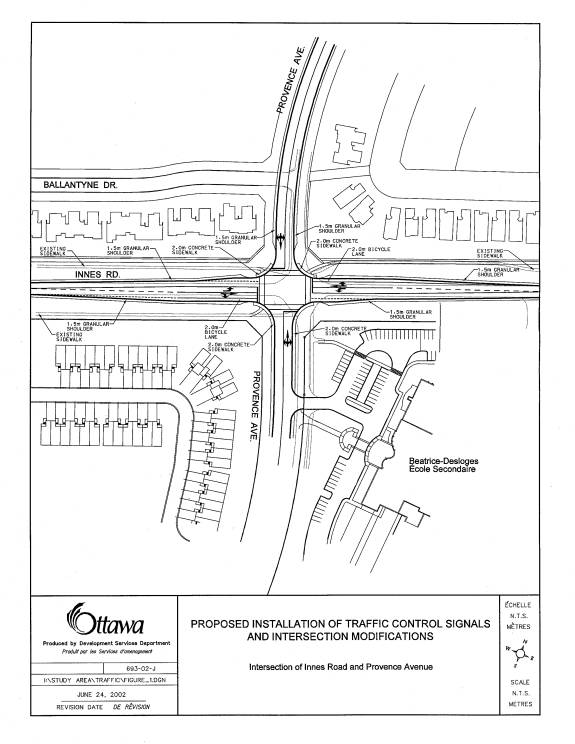
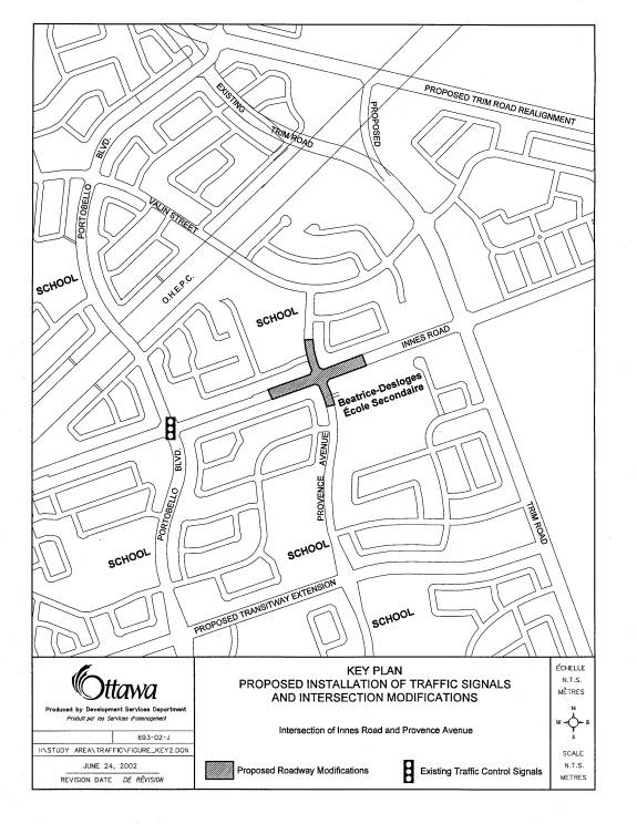
The site and proposed location of the traffic
control signals are shown in Document 1.
DISCUSSION
A Traffic Impact Study Update prepared by the firm
of Cumming Cockburn Limited, dated April 20, 2001, for Claridge Homes, examined
the traffic volumes generated by the developments. The report determined that traffic control signals are not
currently warranted at the intersection of Innes Road and Provence Avenue. However, the developers have been requested
by the City of Ottawa to install traffic control signals in 2002, to improve
traffic operations and safety following development of their sites,
particularly with regard to school pedestrian crossing movements across Innes
Road at this location. Document 2
identifies the modifications proposed to the intersection of Innes Road and
Provence Avenue to accommodate the installation of the Traffic Control Signals
and to improve school pedestrian traffic safety. All other roadway modifications to support the development have
been approved by the former City of Cumberland, and have satisfied the
requirements of the Planning and Municipal Acts.
If approved, the traffic control signal installation
and intersection modifications will be completed during the 2002 construction
season.
ANALYSIS
Existing
Conditions
Land
use in the area north and south of Innes Road is predominantly residential. Schools are located at the intersection of
Provence Avenue and Valin Street north of Innes Road and at the intersection of
Innes Road and Provence Avenue on the south side of Innes Road.
Innes Road is a two-lane arterial roadway, with a
speed limit of 60 km/h in the vicinity of the site.
Innes
Road and Provence Avenue
This
is an unsignalized 4-way intersection with stop controls placed at the
northbound and southbound approaches.
The existing geometry is as follows:
·
Northbound
approach on Provence Avenue – A shared left/through/right lane
·
Southbound
approach on Provence Avenue - A shared left/through/right lane
·
Eastbound
approach on Innes Road - A shared left/through/right lane
·
Westbound
approach on Innes Road - A shared left/through/right lane
Pedestrians
Sidewalks exist in the northwest, northeast, and
southwest quadrants of the existing intersection. Existing Provence Avenue has no sidewalks north and south of
Innes Road.
Pedestrian traffic accessing the École Secondaire
Catholique Béatrice-Desloges is heavy in the morning and afternoon peak
periods. Also students attending Maple
Ridge Elementary School north of Innes Road cross at this intersection.
Bicycles
Innes Road and Provence Avenue have no existing
special facilities along the street to accommodate cycling, such as
separate/shared lanes or signs for cycling use.
Counts carried out over a 8-hour period on May 27,
2002 at the Portobello/Innes Road intersection, indicated 14 cyclists on Innes
Road, 10 travelling in the eastbound direction and 4 traveling in the westbound
direction.
Transit
There are no regular transit route services on this
section of Innes Road. However, route
35 provides some transit service during peak hours on Innes Road west of
Provence Avenue turning north on Provence Avenue and terminating at Maple Ridge
Elementary School.
Automobiles
An 8-hour traffic survey carried out on May 27, 2002
indicates that, approximately 3307 vehicles eastbound and 2744 westbound travel
on this section of Innes Road. On a
24-hour projected basis, the eastbound traffic volume is 6018 vehicles and the
westbound volume is 4992 vehicles.
Design
Proposal
The
design proposal provides for the installation of traffic control signals and
the construction of the following intersection modifications:
·
Eastbound
and westbound left-turn auxiliary lanes on Innes Road
·
Relocation
of Provence Avenue westwards by approximately 10 metres, as indicated on the
approved site plan.
·
Bicycle
lanes on the eastbound and westbound approaches to the intersection extending
approximately 160 metres from the intersection centre line.
·
Installation
of traffic control signals.
·
Shared
left/right/through lanes on the Provence Avenue northbound and southbound
approaches.
Pedestrians
The pedestrian crossings at Innes Road and Provence
Avenue will be controlled by push buttons that actuate an audible pedestrian
phase in the traffic control signal cycle.
Drop curbs at both intersections will be constructed in all quadrants and
will define the pedestrian crossing.
Bicycles
Exclusive bicycle lanes will be provided on each of
the eastbound and westbound approaches to the intersection, extending
approximately 160 metres from the Provence Avenue centre line.
Transit
Existing transit provision will not be changed by the
proposed intersection modifications.
Automobiles
The traffic control signals and intersection
modifications will improve the efficiency of the intersection by mitigating the
effects of increased motor vehicle activity due to traffic growth on Innes Road
and enhance school pedestrian traffic safety and mobility across Innes Road.
CONFORMITY TO THE TRANSPORTATION MASTER PLAN
The guiding principle from the Transportation Master
Plan (TMP) is the provision of a modal hierarchy with the emphasis on walking,
cycling and transit usage. This
principle is reflected in the provision for on-road cycling facilities along
the proposed widened portion of Innes Road.
CONSULTATION
Councilor
McNeely, the Ward Councilor, has been involved in discussions regarding the
proposed improvements to the Innes Road and Provence Avenue intersection and is
fully satisfied with the proposed improvements.
Notice of the proposed Innes Road and Provence
Avenue intersection modifications has been placed in Le Droit and the Citizen for
four consecutive weeks.
FINANCIAL IMPLICATIONS
Should Council approve the above noted traffic
control signal installation and associated intersection modifications, the City
will be contributing funds to the allowable works. Funds are available in Development Charge Reserve Funds under
account numbers 830053 D/C – Roads/Transport. Area 17, (CUMB), and 830057 D/C –
Roads/Transport. Area 22, (CUMB). These
funds were formerly outlined in the former City of Cumberland’s development
charge bylaw. The two bordering
developers on each side of Innes Road, Claridge Homes and Urbandale
Corporation, will pay their share of the balance. The City of Ottawa is requiring the installation of the Traffic
Control Signals to provide safe crossing of Innes Road for students going to
École Secondaire Catholique Béatrice-Desloges and Maple Ridge Elementary
School. Therefore, the City will be
assuming the maintenance and operating costs of the traffic control signals in
the amount of $3,500 per annum.
COST ESTIMATES
The preliminary cost estimate for the road modifications to Innes Road at Provence Avenue is $360,000 based on functional design details. The estimate is provided solely for the information of the Transportation and Transit Committee and City Council.
COMMENTS ON CYCLING
Mobility and Area Traffic Management Division has
reviewed the intersection improvements for Innes Road and Provence Avenue.
ATTACHMENTS
Document 1 – Key Plan
Document 2 – Design Proposal (Traffic Signals and
Intersection Modifications)
DISPOSITION
Based on the approval of the traffic control signal
installation, staff will be required to:
·
Approve
the conditions of the legal agreement and the amount and the provision of any
financial securities that pertain to the project;
·
Provide
project management services; and
·
Authorize
installation services.
Key Plan Document
1
Design Proposal (Traffic Signals and Intersection
Modifications) Document
2