Report to/Rapport au:
Transportation and Transit Committee/
Comité des transport et des
services de transport en commun
and Council/et au Conseil
17 June 2002/ le 17 juin
2002
Submitted by/Soumis par: R.T. Leclair, General Manager/Directrice générale
Transportation, Utilities and
Public Works/Transport, services et travaux publics
Contact/Personne-ressource: Michael J. Flainek, P. Eng., Director/Directeur
Traffic and Parking Operations Branch/Circulation et
Stationnement
Telephone 580-2424, extension
26882, Michael.Flainek@ottawa.ca
|
|
|
Ref N°: ACS2002-TUP-TRF-0026 |
SUBJECT: widening
of west hunt club road from merivale road to 150 m east of laser street/antares
drive for on-street cycling lanes
Modifications
at the intersection of Hunt Club Road and Riverside Drive/River Road and the
intersection of west Hunt Club Road and Prince of Wales Drive
OBJET : ÉLARGISSEMENT DU CHEMIN HUNT CLUB OUEST, DU CHEMIN MERIVALE
À 150 M À L’EST DE LA RUE LASER/PROMENADE ANTARES POUR L’AMÉNAGEMENT DE BANDES
CYCLABLES SUR VOIRIE
MODIFICATIONS
À L’INTERSECTION DU CHEMIN HUNT CLUB ET DE LA PROMENADE RIVERSIDE/CHEMIN RIVER
ET À L’INTERSECTION DU CHEMIN HUNT CLUB OUEST ET DE LA PROMENADE PRINCE OF
WALES
REPORT RECOMMENDATIONS:
That the Transportation and
Transit Committee recommend Council approve:
1.
the widening of the eastbound and westbound
lanes of West Hunt Club Road from Merivale Road to a point 150 m east of Laser
Street/Antares Drive for the provision of on-street cycling lanes as shown in
Annexes 2A to 2F (Drawings HCB-001, HCB-002, HCB-003, HCB-004, HCB-005,
HCB-006);
2.
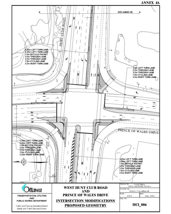
the proposed intersection modifications of
West Hunt Club Road and Prince of Wales Drive as shown in Annex 4A (Drawing
HCI-006);
3.
the proposed roadway modifications on the
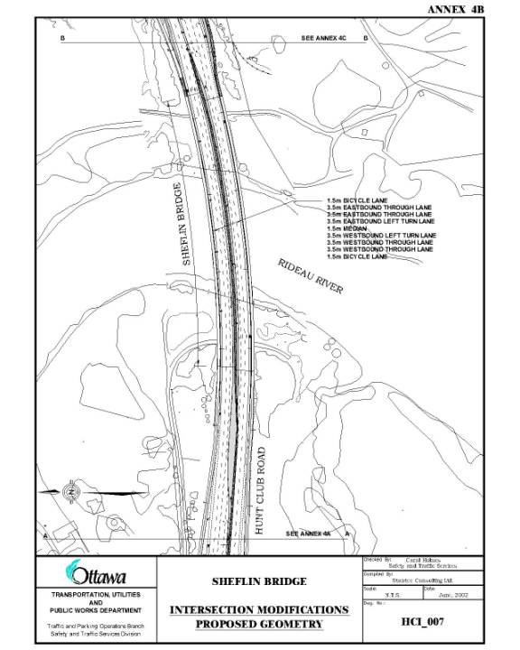
Michael J.E. Sheflin Bridge (Sheflin Bridge), as shown on Annex 4B (Drawing
HCI-007); and,
4.
the proposed intersection modifications of
Hunt Club Road and Riverside Drive/River Road as shown in Annex 4C (Drawing
HCI-008);
subject
to the Public Hearing Process.
RECOMMANDATIONS
DU RAPPORT
Que le Comité des
transports et des services de transport en commun recommande au Conseil
municipal d’approuver :
1.
l’élargissement des voies est-ouest
et ouest-est du chemin Hunt Club Ouest, depuis le chemin Merivale jusqu’à un
point situé à 150 m à l’est de la rue Laser/promenade Antares, en vue de
l’aménagement de bandes cyclables sur voirie, comme il est indiqué dans les
Annexes 2A à 2F (dessins nos HCB-001, HCB-002, HCB-003, HCB-004,
HCB-005, HCB-006);
2.
les modifications projetées à
l’intersection de la promenade Hunt Club Ouest et de la promenade Prince of
Wales, comme il est représenté à l’Annexe 4A (dessin no HCI-006);
3.
les modifications projetées à la
chaussée du pont Sheflin, comme il est représenté à l’Annexe 4B (dessin no
HCI-007); et,
4.
les modifications projetées à
l’intersection du chemin Hunt Club et de la promenade Riverside/chemin River,
comme il est représenté à l’Annexe 4C (dessin no HCI-008);
sous réserve du processus d’audience publique.
BACKGROUND
Cycling Program
West Hunt Club
Road is identified in the Transportation Master Plan as being part of the
designated on-road cycling network in the City of Ottawa. Various sections of West Hunt Club Road have
dedicated on-street cycling lanes.
Given that West Hunt Club Road from Merivale Road to Prince of Wales
Drive is scheduled for an asphalt overlay this year, it is appropriate to
consider roadway widening for the provision of on-street cycling lanes at the
same time as shown in Annexes 1 and 2.
Intersection
Modifications
The intersections of West Hunt Club Road/Prince of Wales Drive and Hunt
Club Road/Riverside Drive/River Road are located on either side of the Michael J.E. Sheflin Bridge (Sheflin Bridge)
that crosses the Rideau River, as shown in Annexes 1 and 2. Riverside Drive/River Road is located on the
east side of the bridge and Prince of Wales Drive is on the west side.
The 2001 Intersection Modification Program identified the intersections
of Hunt Club Road and Prince of Wales Drive and Hunt Club Road and Riverside
Drive/River Road as seriously congested locations. Both intersections have volume to capacity ratios well over 1.0
and, therefore, are failing. In order
to improve the level of service at these intersections for all modes of travel
and reduce delays over the Sheflin Bridge, roadway modifications are required.
On 27 March, as part of the 2002 Capital Budget deliberations, Council
approved funds within the Intersection Modification Program to reduce delay at
these two congested locations.
This report summarizes the preliminary design and public consultation
process followed in determining the proposed intersection modifications for
West Hunt Club Road at Prince of Wales Drive and Hunt Club Road at Riverside
Drive/River Road, and the design for on-street cycling lanes, which form the
basis of the report’s recommendations.
ANALYSIS – INTERSECTION MODIFICATIONS
Existing Conditions
West Hunt Club Road is a four-lane urban divided arterial with posted
speed of 80 km/h as shown in Annexes 2A to 2F.
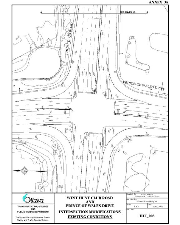
Prince of Wales Drive is a four-lane urban divided roadway at the
intersection of West Hunt Club Road with a posted speed of 60 km/h. It has a rural cross-section with paved
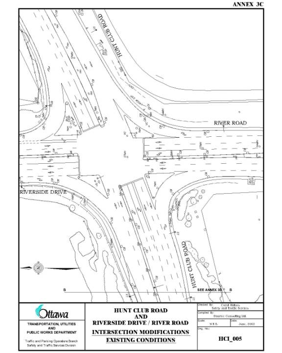
shoulders on the approaches to the intersection, as shown in Annex 3A. Both Hunt Club Road and Riverside Drive are
four lane urban divided arterials with a posted speed limit of 80 km/h, as
shown in Annex 3C. The two
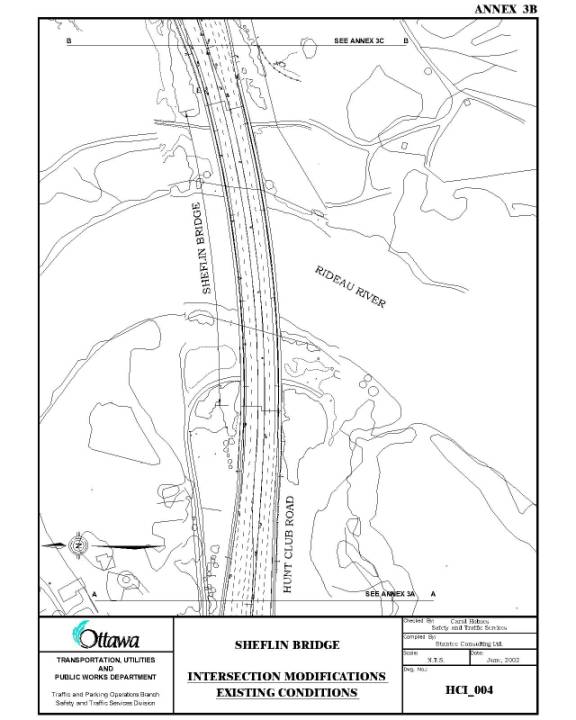
intersections are 585 m apart and are separated by the Sheflin Bridge. The Sheflin Bridge has a divided four-lane
cross-section with sidewalks on both sides.
The sidewalks are protected by Jersey barriers. The recommended offset from the Jersey
barriers to the travel lanes is 1.5 m.
This area is used as a designated cycling lane. See Annex 3B. The two intersections on either side of the bridge are controlled
by traffic control signals but during peak travel periods the intersections are
failing, with severe congestion and long delays. The existing geometry of the two intersections and the bridge are
shown in Annexes 3A, 3B and 3C.
Pedestrians
Currently, there are various treatments used along the roadways for
pedestrians. Eight-hour traffic counts
done at the Hunt Club Road at Prince of Wales Drive and the Hunt Club Road at
Riverside Drive/River Road intersections show that there are relatively low
numbers of pedestrians crossing at these intersections. The count done on 16 May 2002 at Hunt Club
Road and Riverside Drive indicated 17 pedestrians crossed at this intersection
in eight hours while the count done on 18 July 2001 at Hunt Club Road and
Prince of Wales Drive indicated 54 pedestrians crossed at this intersection in
eleven hours.
Cyclists
Cycling lanes are provided on the bridge structure within the offset
area adjacent to the Jersey barriers.
As well, there is an eastbound left-turn bicycle pocket provided on Hunt
Club Road at Riverside Drive. At all
other approaches to the two intersections, cyclists must share the road with
vehicles. During the 18 July 2001 count
at Hunt Club Road and Prince of Wales Drive, 400 cyclists traveled through the
intersection. The 16 May 2002 count at
Hunt Club Road and Riverside Drive indicated that 35 cyclists traveled through
that intersection under wet conditions.
Transit
There are existing transit routes on Hunt Club Road (Routes 116, 119
and 196), Riverside Drive/River Road (Route 196) and Prince of Wales Drive
(Route 175). Bus stops are located on
the northeast corner island at Hunt Club Road and Riverside Drive for westbound
transit users and in a bus bay east of Riverside Drive on Hunt Club Road for
eastbound users. A bus stop is located
on River Road south of Hunt Club Road for southbound transit users. There is presently no transit route on Riverside
Drive from Hunt Club Road. Bus stops
are located both on the north and south side of West Hunt Club Road west of
Prince of Wales Drive. The bus stops on
Prince of Wales Drive are located outside of the area of construction.
Automobiles
The 8-hour traffic count conducted in May 2002 at Hunt Club Road and
Riverside Drive indicated that approximately 31,000 (AADT 56,500) vehicles
traveled on Hunt Club Road across the Sheflin Bridge, and 12,000 (AADT 22,000)
entered the intersection from Riverside Drive.
The 11-hour count conducted in July 2001, indicated that approximately
19,000 (AADT 34,500) vehicles entered the intersection from Prince of Wales
Drive. During the three-year period
ending 31 December 2001, 80 collisions were reported at the Hunt Club Road and
Riverside Drive/River Road intersection and 74 collisions at the West Hunt Club
Road and Prince of Wales Drive intersection.
These two intersections rank fifth and twenty-second respectively in the
Frequency Ranking Report of Traffic Collision Locations
DISCUSSION
Design Proposal
Intersection Modifications
The two intersections on either side of the Sheflin Bridge experience
high volumes of traffic and will experience increasing traffic volumes as lands
to the south continue to develop. Both
intersections are failing at present and must be treated as a pair in order to
provide any benefit to the road users.
The bridge is a major constraint in the ability to improve the
performance of these intersections as the amount of storage available between
Riverside Drive and Prince of Wales Drive and the number of lanes on the
structure is dictated by the width of the bridge.
Roadway modifications are proposed for both intersections, as well as
modifications to the lane arrangements on the bridge deck. The modifications at the intersection are
planned for late Summer/Autumn 2002 but the changes on the bridge and the
median approaching Riverside Drive will occur with the rehabilitation of the
Sheflin Bridge scheduled for 2005, subject to budgetary approvals. The proposed changes are as follows:
Hunt Club Road and Prince of Wales
Drive:
1.
Improve
pedestrian crossing through channelized northbound right-turn on southeast
corner;
2.
Provision of
cycling lanes on the eastbound, westbound and southbound approaches to the
intersection;
3.
Provision of
southbound, eastbound and westbound left-turn bicycle pockets;
4.
Lengthening of
the eastbound left-turn lane;
5.
Provision of an
additional eastbound left-turn lane;
6.
Lengthening of
the double westbound left-turn lane;
7.
Lengthening of
the southbound right-turn lane; and,
8.
Addition of a
second southbound left-turn lane.
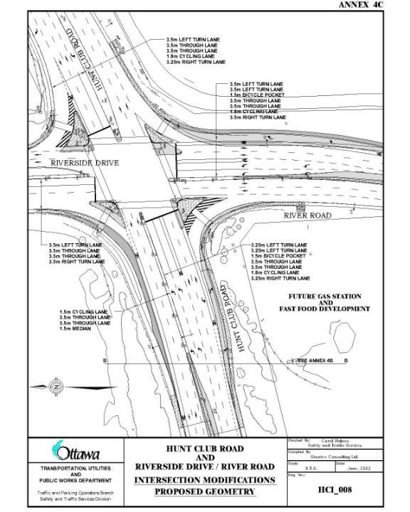
Hunt Club Road and Riverside Drive/River
Road:
1.
Provision of
cycling lanes on the northbound, southbound and eastbound approaches;
2.
Addition of a
northbound left-turn bicycle pocket;
3.
Lengthening of
the eastbound left-turn lane (to be done with bridge works);
4.
Lengthening of
the eastbound right-turn lane;
5.
Removal of the
southbound to westbound right-turn acceleration lane;
6.
Removal of the
westbound to northbound right-turn acceleration lane; and,
7.
Addition of a
second northbound left-turn lane.
Sheflin Bridge:
Providing an an extension of the auxiliary
left-turn lane in the eastbound and westbound direction for the full length of
the bridge to provide storage for left-turning vehicles.
Lane widths are shown on Annexes 4A, 4B and 4C. All double left-turn lanes will operate on
their own traffic control signal phase thus reducing the number of turning
movement collisions at these two intersections. Past studies have shown that this type of measure reduces these
collisions by 85%.
Design Proposal
for Cycling Lanes
West Hunt Club
Road - Westbound Lanes:
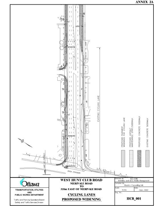
Between Merivale
Road and the CNR Bridge, road widenings between 1.8 and 2.0 m are proposed
along the north side of Hunt Club Road to accommodate the on-street cycling
lane. At the west side of the CNR
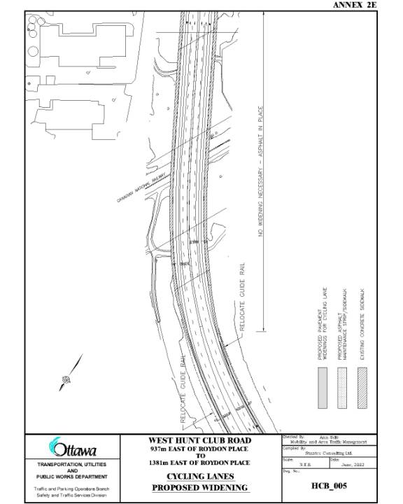
Bridge, the existing guiderail will be relocated as well. At the CNR Bridge, the structure was built
to accommodate three lanes in the westbound direction, however, only two lanes
are in use and, therefore, no widening is required to accommodate the proposed
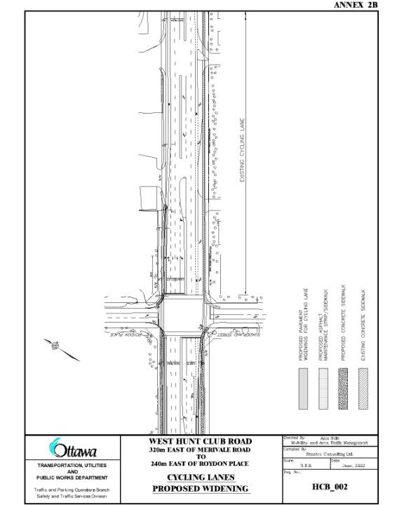
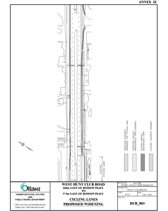
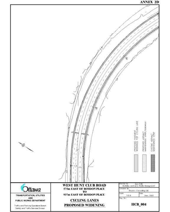
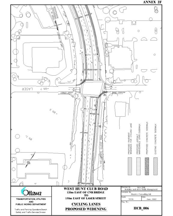
cycling lane. See Annexes 2A, 2B, 2C and 2D.
Between the CNR
Bridge and 150 m east of Laser Street/Antares Drive, only a minor road widening
of approximately 0.5 m is required to accommodate the proposed cycling
lane. See Annexes 2E and 2F.
West Hunt Club
Road - Eastbound Lanes:
In the eastbound
direction sections of 2.0 m cycling lanes already exist. A 2.0 m widening is required in areas to
provide a continuous cycling lane from Merivale Road to the CNR Bridge. At the west side of the CNR Bridge, the
existing guiderail will be relocated for the proposed on-street cycling
lane. In this direction, as well, the
bridge structure is wide enough to provide the cycling lane. See Annexes 2A, 2B, 2C and 2D.
Between the CNR
Bridge and 150 m east of Laser Street/Antares Drive, only a minor road widening
of approximately 0.5 m is required to accommodate the proposed cycling
lane. See Annexes 2E and 2F.
Proposal for
Pedestrian Sidewalk
West Hunt Club
Road - North Side:
A 2.0 m concrete
sidewalk with boulevard are proposed between Merivale Road and Roydon Place
since the westbound lanes are developed to their ultimate three lane
cross-section. No sidewalk would be provided
on the north side from Roydon Place to Laser Street. Pedestrians on the north side of West Hunt Club Road would be
required to cross to the south side of the street to continue to Laser Street.
West Hunt Club
Road - South Side:
Sections of concrete
sidewalk have been constructed as part of several recent commercial
developments that are slightly more predominant along the south side of West
Hunt Club Road. It is proposed that, as
part of the roadway widening, additional sections are built, to provide a
continuous 2.0 m sidewalk from Merivale Road to a point 300 m east of
Sunderland Street. It is also
recommended that from a point 300 m east of Sunderland Street to the west side
of the CNR Bridge, that the existing 1.5 m asphalt strip be widened to 2.0
m. Over the CNR structure a 2.0 m
concrete sidewalk already exists. From
the east side of the CNR Bridge to Antares Street, a 2.0 m asphalt sidewalk is
proposed. The existing guide rail on
the east side of the bridge must be relocated to transition from the existing
concrete sidewalk to the proposed asphalt sidewalk.
These proposals
will provide a continuous sidewalk from Merivale Road to Antares Street. East of Antares Street, provision of an
asphalt sidewalk is difficult due to the rural cross-section of the roadway
that consists of ditches adjacent to the edge of the shoulder. Staff are examining ways in which a
pedestrian facility could be provided, given the existing grading issues. The asphalt sidewalk will either be
installed at the existing grade or constructed with curb adjacent to the
cycling lane; this will be determined during the detailed design process. An existing sidewalk is in place from Prince
of Wales Drive to Riverside Drive over the Sheflin Bridge.
Future plans also
include the construction of a sidewalk on the south side of Hunt Club Road from
Riverside Drive to Bowesville Road. The
north side is not feasible because of property line constraints.
Should West Hunt
Club Road be widened to a six-lane cross-section in the future, it is planned
that a full concrete sidewalk, located in the boulevard, be installed for the
section from 300 m east of Sunderland Street to Prince of Wales Drive. The asphalt maintenance strip/sidewalk proposed
will be a temporary measure, as the cost of constructing a sidewalk with
asphalt is approximately half of the construction cost with concrete.
Design Features
– Intersection Modifications
Numerous treatments exist for pedestrians at the West Hunt Club Road
and Prince of Wales Drive and Hunt Club Road and Riverside Drive/River Road
intersections and along the adjoining roadways. The proposed design either maintains the existing curbside
treatment or improves it to provide sidewalks that direct pedestrians to a
specific destination.
Cycling lanes will be provided on all the approaches to the two
intersections for the length of the construction where widening is occurring
(Annexes 4A, 4B and 4C). In an effort
to coordinate the proposed cycling lanes on Hunt Club Road from Merivale Road
to 150 m east of Laser Street/Antares Drive with these proposed intersection
modifications, the 2.0 m cycling lanes on the eastbound approach and westbound
departure from Prince of Wales Drive will continue westerly along Hunt Club
Road and tie in with the cycling lanes at approximately 150 m east of Laser
Street/Antares Drive.
An existing bicycle pocket is located on the eastbound approach of Hunt
Club Road to Riverside Drive between the straight through lanes and the double
left-turn lanes. Similar bicycle
pockets are proposed along all double left-turn lanes at these two
intersections. These bicycle pockets
will be monitored and evaluated for future installation at other
locations. The bicycle pockets are 1.5
m wide and 30 m in length and are shown on the proposed geometry plans (Annexes
4A and 4C).
The provision of the proposed intersection modifications at the two
intersections and over the Sheflin Bridge will reduce driver delays and enhance
safety for all users traveling in this area.
ENVIRONMENTAL IMPLICATIONS
No environmental implications directly arise from approval of this report.
RURAL IMPLICATIONS
N/A
CONSULTATION
The proposed intersection modifications at the West Hunt Club Road and
Prince of Wales and Hunt Club Road and Riverside Drive/River Road, including
the extension of auxiliary left turn lanes across the Sheflin Bridge and the
proposed on-street cycling lanes fall under Schedule “A” of the Class
Environmental Assessment for Municipal Road Projects. As per Section 300 of the Municipal Act, R.S.O. 1990, c.M.45, as
amended, a notice of the proposed roadway modifications has been placed in Le
Droit and the Ottawa Citizen newspapers for four consecutive weeks, starting 14
June 2002. An information flyer was
sent out to the affected businesses and property owners abutting West Hunt Club
Road from Merivale Road to Prince of Wales Drive. No Public Open Houses were undertaken due to the commercial
nature of West Hunt Club Road.
The design proposals for the intersection modifications at Prince of
Wales Drive and Riverside Drive/River Road have been discussed with the two
affected Ward Councillors and both supported the modifications. Both Councillors have discussed these
proposed modifications with their constituents when attending community
association meetings.
Temporary signs advising pedestrians, cyclists and motorists that
“cycling lanes and roadway modifications are proposed” have been placed at the
Merivale Road, Prince of Wales Drive and Riverside Drive/River Road
intersections along West Hunt Club Road on 24 June 2002. The signs display a telephone number at
which comments and concerns can be left and from which additional information
can be obtained, if the caller wishes to discuss the matter with staff.
TRANSPORTATION MASTER PLAN
A guiding principle of the Transportation Master Plan (TMP) is the
provision of a modal hierarchy with emphasis on walking, cycling and transit
use. This principle is reflected in the
following features of the proposed intersection modifications at Prince of
Wales Drive and Riverside Drive/River Road that directly conform to the TMP:
1. The provision of concrete sidewalks to bus stop pads will provide transit users with a safe and convenient way to travel from the bus stop to the intersection, which conforms to Section 2.4.1, Item 8 of the TMP.
2. The provision of cycling lanes within the area of construction will connect the proposed cycling lanes on Hunt Club Road west of Prince of Wales to the cycling lanes on the bridge and through the intersections, which conforms to Section 2.3.2, Item 3 of the TMP.
3. The provision of additional turning lanes and extension of existing turning lanes will maximize the operational efficiency of the existing infrastructure that will improve operations for transit use and the efficient goods movement system in this area and supports the Transportation System Management (TSM) strategy. This conforms to Section 2.5.2 and 2.5.3 of the TMP.
West Hunt Club Road, from Merivale Road to Antares Drive/Laser Street, is designated as part of the on-road cycling network in the Transportation Master Plan – Map 1 – Cycling Transportation Network. Section 2.3.2 of the Transportation Master Plan, approved by the former Region, provides direction:
“Implement the portions of the Cycling Transportation Network under RMOC jurisdiction, as shown on the Cycling Transportation Network Map, actively promote implementation of portions of the network that are under other jurisdictions, and support its harmonization with the overall transportation network and other cycling networks in the Region.”
FINANCIAL IMPLICATIONS
The total estimated cost
for the design and installation of the intersection modifications and
construction supervision of the West Hunt Club Road and Prince of Wales Drive
and Hunt Club Road and Riverside Drive/River Road intersections is $1,400,000
(this includes GST). Funds are
available in the 2002 Capital Budget, Order Number 900441, Intersection
Modification Program.
The total estimated cost
for the design, installation and construction supervision of the on-street
cycling lanes on West Hunt Club Road from Merivale Road to a point 150 m east
of Laser Street/Antares Drive is $798,000 (this includes GST). Funds in
the amount of $365,000 were approved as part of the 2002 Capital Budget,
Internal Order Number 901089. In
addition, $433,000 is also available in Internal Order Number 900677.
The Surface Operations
Branch requires additional annual funding in the amount of $9,300 to maintain
the proposed roadway modifications and new sidewalks. These funds will be identified in the 2003 Operating Budget.
DISPOSITION
Subject to approval of the recommendations
contained in this report by Council, construction will begin in the late Summer
of 2002 and will be completed by Winter 2002.
ATTACHMENTS
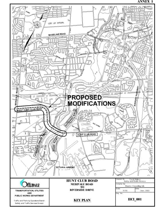
ANNEX 1 KEY PLAN –West Hunt Club Road On-Street
Cycling Lanes and Intersection Modifications
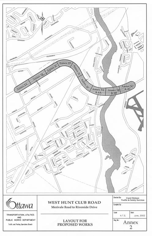
ANNEX 2 LAY OUT FOR PROPOSED WORKS
ANNEX 2A WEST HUNT CLUB ROAD - Merivale Road to 320
m east of Merivale Road – cycling lanes – Proposed Widening
ANNEX 2B WEST HUNT CLUB ROAD – 320 m east of
Merivale Road to 240 m east of Roydon Place – Cycling Lanes – Proposed Widening
ANNEX 2C WEST HUNT CLUB ROAD – 240 m east of Roydon
Place to 575 m east of Roydon Place – Cycling Lanes – Proposed Widening
ANNEX 2D WEST HUNT CLUB ROAD – 575 m east of Roydon
Place to 937 m east of Roydon Place – Cycling Lanes – Proposed Widening
ANNEX 2E WEST HUNT CLUB ROAD – 937 m east of Roydon
Place to 1331 m east of Roydon Place – Cycling Lanes – Proposed Widening
ANNEX 2F WEST HUNT CLUB ROAD – 120 m east of CNR
Bridge to 150 m east of Laser Street – Cycling Lanes – Proposed Widening
ANNEX 3A INTERSECTION MODIFICATIONS – EXISTING
GEOMETRY – West Hunt Club Road and Prince of Wales Drive
ANNEX 3B INTERSECTION MODIFICATIONS – EXISTING
GEOMETRY – Sheflin Bridge
ANNEX 3C INTERSECTION MODIFICATIONS – EXISTING
GEOMETRY – Hunt Club Road and Riverside Drive/River Road
ANNEX 4A INTERSECTION MODIFICATIONS – PROPOSED
GEOMETRY – West Hunt Club Road and Prince of Wales Drive
ANNEX 4B INTERSECTION MODIFICATION - PROPOSED
GEOMETRY – Sheflin Bridge
ANNEX 4C INTERSECTION MODIFICATION – PROPOSED
GEOMETRY – Hunt Club Road and Riverside Drive/River Road
ANNEX 1
KEY PLAN – West Hunt Club Road On-Street Cycling Lanes
and Intersection Modifications
ANNEX
2
LAY OUT FOR PROPOSED WORKS
ANNEX 2A
WEST HUNT CLUB ROAD - Merivale Road to 320 m east to Merivale Road –
Cycling Lanes – Proposed Widening
ANNEX
2B
WEST HUNT CLUB ROAD – 320 m
east of Merivale Road to 240 m east of Roydon Place – Cycling Lanes – Proposed
Widening
ANNEX 2C
WEST HUNT CLUB ROAD – 245 m east of Roydon
Place to 575 m east of Roydon
Place – Cycling Lanes – Proposed Widening
ANNEX 2D
WEST HUNT CLUB ROAD – 575 m east of Roydon Place to 937 m east of Roydon
Place – Cycling Lanes – Proposed Widening
ANNEX
2E
WEST HUNT CLUB ROAD – 937 m
east of Roydon Place to 1331 m east of Roydon Place – Cycling Lanes – Proposed
Widening
ANNEX
2F
WEST HUNT CLUB ROAD – 120 m
east of CNR Bridge to 150 m east of Laser Street – Cycling Lanes – Proposed
Widening
ANNEX 3A
INTERSECTION MODIFICATIONS – EXISTING GEOMETRY – West Hunt Club Road and Prince of Wales Drive
ANNEX 3B
INTERSECTION
MODIFICATIONS – EXISTING GEOMETRY – Sheflin Bridge
ANNEX 3C
INTERSECTION MODIFICATIONS – EXISTING GEOMETRY – Hunt Club Road and
Riverside Drive/River Road
ANNEX 4A
INTERSECTION MODIFICATIONS – PROPOSED GEOMETRY – West Hunt Club Road and
Prince of Wales Drive
ANNEX 4B
INTERSECTION
MODIFICATION - PROPOSED GEOMETRY – Sheflin Bridge
ANNEX 4C
INTERSECTION MODIFICATION – PROPOSED GEOMETRY – Hunt Club Road and
Riverside Drive/River Road