Joint
Agricultural and Rural Affairs Committee and
Planning and Environment
Committee
Réunion conjointe du
Comité de l’agriculture et des questions rurales et du
Comité de l’urbanisme
et de l’environnement
28 January 2009 / le 28 janvier 2009
Submitted
by/Soumis par : Nancy Schepers, Deputy City Manager/
Directrice municipale adjointe,
Infrastructure Services and
Community Sustainability/
Services d’infrastructure et
Viabilité des collectivités
Contact Person/Personne-ressource: Richard Kilstrom, Manager/
Gestionnaire, Community Planning and
Design/Aménagement et conception communautaire, Planning and Growth
Management/Urbanisme et Gestion de la croissance
(613) 580-2424 x22653,
Richard.Kilstrom@ottawa.ca
That staff be directed to circulate the proposed
amendment to the City of Ottawa Official Plan (Five-year Comprehensive Official
Plan Review) as detailed in Document 1 and the revised Infrastructure Master
Plan as detailed in Document 2, and to schedule a public meeting for March 31,
2009.
Que le personnel soit
chargé de diffuser la modification proposée au Plan officiel de la Ville
d’Ottawa (révision détaillée quinquennale du Plan officiel), telle qu’exposée
en détail dans le Document 1, et le Plan directeur de l’infrastructure révisé,
tel qu’exposé en détail dans le Document 2, et de mettre au calendrier une
réunion publique le 31 mars 2009.
In November 2008, staff presented a report that provided comprehensive information about the proposed changes to the Official Plan and Infrastructure Master Plan, including the background rationale and implications for future land-use planning. That report is available at: http://www.ottawa.ca/calendar/ottawa/citycouncil/pec/2008/11-24/agendaindex44.htm
At that time, staff indicated that in early 2009, the proposed changes to the Official Plan would be tabled to initiate the formal amendment process. That would be done in conjunction with proposed revisions to the Infrastructure Master Plan.
The purpose of this report is to:
1. Confirm the process and timeline for Council adoption of an Official Plan Amendment and approval of a revised Infrastructure Master Plan.
2. Make some updates to the proposed policies in the Official Plan based on recent input and clarifications.
3. Report on some matters that were not available in November, including:
· The revised Infrastructure Master Plan;
· The comprehensive review as a basis for an Employment Lands Strategy;
· The identification of recommended locations for the urban boundary rationalization;
· A report on the costs associated with implementation of the Official Plan and Master Plans;
· A report on the relative costs of growth in different areas of the city, in response to Motion 18/33;
· A review of the survey on intensification;
· A response to Motion 47/15 on growth management.
Public notification: This marks the beginning of the legislated Official Plan Amendment process. The proposed Official Plan Amendment and revised Infrastructure Master Plan will not be circulated in hard copy unless specifically requested. Notification will occur through:
· Newspaper advertisements in the local papers and daily papers,
· An e-newsletter to the mailing list of over 3,000 individuals and organizations,
· Updating the City’s website,
· Links to the Councillors’ websites, and
· Links to the Federation of Citizens’ Association’s website and the websites of other groups who agree to do so.
Staff will contact by letter any individual landowner affected by a proposed change in land-use designation.
Open House: As required by the Planning Act, staff will hold an open house to provide answers to questions related to the Official Plan or Infrastructure Master Plan. The Act requires one open house. Since staff have already held many such information meetings, the intent is to hold two additional ones before the end of February: one to focus on rural matters and one to focus on urban matters. Staff are also available to meet with Councillors, groups and individuals on specific matters as they arise.
Public Meeting: A public meeting before a Joint Meeting of Planning and Environment Committee and Agriculture and Rural Affairs Committee will be advertised for March 31, 2009.
Following the public meeting the Official Plan Amendment will go to City Council for adoption and then to the Minister of Municipal Affairs for approval.
The Draft Official Plan Amendment is attached as Document 1. The text is substantially the same as the document tabled and explained in November 2008. Document 1 includes a list of sections that have changed with an explanation. Those text changes since the November version are identified as “[NEW]”. A number of new Schedules are included in Document 1.
These requests have arisen in two contexts. The first includes two requests to consider lands as candidate areas for urban expansion based on a review of the agricultural attributes of the land. One is an Official Plan Amendment application by Mattamy and has not been agreed to as the LEAR score is higher than the 130-point threshold for Agricultural Resource Areas. The second is a request by Minto and has been agreed to be considered as a candidate area for urban expansion because the lands to the north are urban and to the west are General Rural and the current LEAR score is less than 130 points (see Annex 2 to Document 3).
In both of these cases the consultants argued that various aspects of the LEAR scores should be re-evaluated and in fact the methodology revisited to reflect changes in the Agricultural industry as well as changes in land use. This may very well be true and staff will initiate a study to review the LEAR approach and scores for the city as a whole. In that way, the criteria will be applied consistently across the city. This was also a request of the Agricultural Working Group who met as part of the Rural Review. Should the Minto parcel not be included as an urban expansion area, it will continue to be designated Agricultural Resource Area pending completion of the city-wide study.
There are also three requests to address the Agricultural Resource Area designation unrelated to the urban area expansion. Staff have received a request from J.L Richards (with Weston Graham Associates) relating to Part of the West half of lot 30, Concession 2, Rideau Front. This request is for the application of a General Rural Area designation in place of the Agricultural Resource Area designation. The LEAR score is below the threshold for good agricultural potential. However, parcels on three sides of the subject site are still designated Agricultural Resource Area. When the City reviews the LEAR process, it may very well be that these lands are re-evaluated and designated differently. However, for consistency, the designation should not be changed at this time.
Staff have also received a request from Novatech Engineering on behalf of the owners of the Highland Park Cemetery to redesignate the cemetery site in West Carleton from Agricultural Resource Area to General Rural Area. In addition there has been a proposal from the Upton Group to develop Agricultural Resource Area along the Rideau River north of Kars as a new “settlement area”. This would only be considered if the property was not designated Agricultural. Both of these proposals will be considered after the city-wide review of the LEAR.
Staff will initiate work on the review of the LEAR late in the spring, with input from the Ontario Ministry of Agriculture and Food. Typically a committee of farmers, staff, agricultural experts and other representatives in the community will direct such a review. Such a committee can only focus on this work from November to February during an inactive period in farming. Therefore, a schedule will be created that responds to this requirement. Background work will begin in early summer 2009 and Committee work will be initiated by November 2009.
The Infrastructure Master Plan (Document 2) was not available in November although staff presented the main elements of the Plan. Four key changes are being proposed for the Infrastructure Master Plan (IMP):
Capacity Management Strategy: To deal with the demands of intensification and the limitations of its older infrastructure, the City has developed a Capacity Management Strategy with more detailed policy and implementation guidance than is currently available in the existing Infrastructure Master Plan policies in the following ways:
· Giving higher priority and more financial support to the assessment of system capacity;
· Giving priority to determining solutions and scheduling works for intensification and density target areas to provide both capacity for growth and to meet the needs of existing residents;
· Recommending changes through the review of development applications (e.g. to increase on-site retention of stormwater);
· Undertaking public and private capacity building projects including innovative ways to involve and work with the development community; and
· Providing additional funding for non-traditional infrastructure programs (such as water efficiency, water loss, green infrastructure and flow management) to reduce reliance on “bigger pipe” capacity building solutions.
Groundwater Management Strategy: Council adopted “The Groundwater Management Strategy” in May, 2003 and changes to the Infrastructure Master Plan policies have been proposed to reflect the direction of the adopted Strategy. The tasks proposed in the Strategy have been divided into two phases:
· For Phase 1, the City has been continuing and expanding its existing work on data collection and characterization of groundwater resources and public education.
· For Phase 2, the City will undertake the remaining tasks outlined in the strategy including: identification of contaminant sources; groundwater use assessment; trends in quality and level of groundwater; best management practices; and groundwater protection policies and legislation.
Stormwater Management Strategy: Council adopted stormwater management policies in September of 2007. These are being incorporated into the Infrastructure Master Plan. The policies were developed to provide direction to:
· City plans for stormwater management in greenfield areas;
· Retrofitting of existing areas that have been developed without stormwater management; and
· Stormwater management needs related to intensification.
Water, Wastewater and Stormwater Projects: The IMP contains a list of programs and major projects required between 2009 and 2019, and between 2020 and 2031 to support the population and employment projections and growth objectives of the Official Plan. These include: water feedermains, pump stations and reservoirs, elevated tanks and treatment plant upgrades. With respect to wastewater, the list includes wastewater collectors and treatment plant upgrades. Programs and projects that support intensification through the capacity management strategy, community-specific projects and village water and wastewater projects are separately identified. For stormwater management projects, the list includes ponds and erosion control works.
Metropolitan Knowledge International completed a comprehensive review of Employment Lands in Ottawa as part of its Phase 1 work for the Employment Lands Strategy as required by the Provincial Policy Statement. The report was provided to Planning and Environment Committee on January 27, 2009. The Phase 1 findings concluded that no additional Employment Lands are required in the Urban or Rural Area. However, it did identify two critical issues:
· Not enough employment lands are located in areas of high demand; and
· Servicing and other constraints currently limit the supply available to meet demand.
Phase 2 of the study will, among other things, identify what needs to be done to develop a strategy to address the issues identified above. It is anticipated that it could be brought to the above-noted Committee sometime in March 2009. No changes to the employment area designations are anticipated at this time.
The Residential Land Strategy indicated a requirement in the planning period for an additional 850 gross hectares of urban residential land. Staff have done a comparative review of more than 2,000 ha of primarily General Rural Area and are recommending some additional work to investigate the cumulative impact on infrastructure and to consider economies of scale. Document 3 presents that analysis and identifies the recommended actions. At this time no specific lands are being recommended for inclusion and the relative ranking of parcels will likely change as additional work is completed.
The Official Plan (OP) guides, at a high level, all land-use in Ottawa, and ultimately shapes how the City will accommodate growth and change. In many ways the Master Plans are supporting documents to the Official Plan in that they provide strategies to facilitate growth in particular locations or at particular densities. On the other hand, the Master Plans can be significant determinants of growth patterns. The ability of a light rail system to shape the way the city grows is unparalleled in recent history. The Plans therefore must be implemented in unison to achieve Council’s objectives for the future of the City. Document 4 details the financial implications and affordability of the Official Plan, Infrastructure Master Plan and Transportation Master Plan based on the 22-year term of the Official Plan. The following paragraphs summarize that document.
The Official Plan:
Implementing the Official Plan requires the City to undertake tasks and programs that may have budget pressure implications for the City. In accordance with the Planning Act, the City is also required to undertake certain on-going tasks to keep the Official Plan current. Many of these also carry budget implications for the City. The OP tasks that require funding by the City (as opposed to being funded by developers/private sector) are described in Document 4, and include the five-year reviews of the OP itself and its secondary plans, monitoring growth, preparing of Community Design Plans, implementing Design Priority Areas, and identifying and protecting Natural Heritage Systems. The cost for Natural Heritage Systems and related environmental tasks over the 22-year term is $73M, and the cost of the remaining OP tasks is $25.5M over that same term, for a total of $98.5M. A breakdown of costs to achieve these, and their funding sources, is included in Document 4.
The Infrastructure Master Plan:
The Infrastructure Master Plan (IMP) describes the major water, wastewater and stormwater capital works to service Official Plan estimates for population, households and employment to the year 2031, the term of this OP, and is estimated to cost $1.6B over that period. Over half of this cost is growth-related, and eligible for Development Charge funding. Document 4 breaks down these capital works by type, cost and funding source, and describes the details of growth-related versus rehabilitation.
The Transportation Master Plan:
The implementation of the Transportation Master Plan (TMP) will cost approximately $8.36B in new infrastructure and services over the 22-year term of the OP. Document 4 details the capital costs, operating and maintenance costs, and funding sources for rapid transit, transit priority, bus garages, transportation demand management and roads (including provisions for pedestrians and cyclists). The TMP was approved by City Council on November 26, 2008.
Development Charges as a Revenue Source:
The final section of Document 4 explains how Development Charges function, how they generally promote the principle of “growth pays for growth,” and the challenges of Development Charges as a funding source.
Council motion 18/33 was adopted on July 11, 2007 in respect of the 2007-2010 Draft City Strategic Directions report, as follows:
BE IT RESOLVED That section c under Transformation Priorities be amended by adding a new point to read as follows,
"10. Following the principles of Ottawa 20/20, ensure the review of the Official Plan includes:
a) The impact on the operating and capital budgets of development in each of these areas: inside the greenbelt; within the urban boundary outside the greenbelt; within villages; and in rural Ottawa outside of village boundaries,
b) A review of the effective measures to direct growth.”
A consultant study was commissioned to respond to part a) of the motion and the technical report, “Comparative Municipal Fiscal Impact Analysis”, Hemson Consulting Ltd., is attached as Document 5. It examines the operating and capital costs of residential development in each of the four areas compared to the associated tax revenue to the City. It should be noted that due to the complexity of the analysis, the numbers cited are more indications of the comparative situation rather than measures of absolute differences. Its conclusions are as summarized below:
1. Development inside the Greenbelt generates a surplus of revenues over costs of approximately $1,000 per additional household or $450 per capita. Figures will vary depending on whether infrastructure upgrades are required to accommodate new development;
2. In urban areas outside the Greenbelt, costs are slightly higher than revenues by approximately $70 per additional household or $25 per capita;
3. Development in villages costs more to service than the revenue it generates by approximately $500 per new household or roughly $175 per capita; and
4. In rural areas outside villages, the cost of new development exceeds revenue by approximately $160 per household or about $55 per capita.
With regard to part b) of the motion, “a review of the effective measures to direct growth” the answer is multi-faceted. The Official Plan is the main document for directing growth. For example, the proposed policies require that intensification targets be met prior to the consideration of any urban boundary expansions. City priorities for transportation and piped infrastructure improvements provide opportunities for development in some areas over others. Measures such as Development Charges can vary by area to encourage development in priority areas.
The Hemson study concluded that while there were opportunities to influence the location of residential development, it is much more difficult for a variety of reasons to influence the location of non-residential development.
Motion 47/15 was moved by Councillor Leadman and seconded by Councillor Doucet and carried by Planning and Environment Committee. It raises a number of matters mainly related to growth management within and outside of the Greenbelt. Document 6 presents the staff response to the motion. Each of the concerns raised by the Councillors is being addressed in the revised Official Plan.
BE IT RESOLVED that the following motion be referred to the consideration by Council of the Official Plan Review on 10 December 2008:
WHEREAS The City of Ottawa is reviewing its Official Plan (OP) - the central guiding document that presents a unified vision on how Ottawa will develop. Under this review, the City is committed to improve its policies by ways of the Mid-Term Governance Review, Development Charges By-Law and the Development Approval Processes;
THEREFORE BE IT RESOLVED THAT City staff be directed to report to Committee and Council on methods and additional provisions in the draft Official Plan to enhance City Ontario Municipal Board (OMB) cases on zoning and development matters including but not limited to emphasis on compatibility, serviceability and community design plans;
BE IT FURTHER RESOLVED THAT City staff be directed to report to Committee and Council on methods and additional provisions in the draft Official Plan to meet development targets in a diffused manner across each area minimizing focus upon single site development where possible;
BE IT FURTHER RESOLVED THAT City staff be directed to report to Committee and Council on methods and provisions in the draft Official Plan to encourage sustainable development outside the greenbelt with focus upon building vibrant town centers and main streets with local economic development strategies;
BE IT FURTHER RESOLVED THAT City staff be directed to report to Committee and Council on progress on the staff led review underway on the development approval process with specific mention to:
· Encourage developers to promote architectural creativity and vibrant streetscapes and sub divisions;
· Decrease review time to improve service to the development industry;
Establish local design review committees with feedback integrated into the design review process;
BE IT FURTHER RESOLVED THAT City Staff be directed to report to Committee and Council on progress on this motion at the tabling of the Draft Official Plan review and be included within the scope of the Official Plan public consultation.
As part of the Official Plan review, staff organized an Intensification Forum consisting of two public sessions at Ben Franklin Place on the evenings of May 29 and June 3, 2008. Two broad topics were each addressed, one at each session:
Four different experts from across the country were invited to speak each night on these subjects in a moderated session that allowed for interaction with the audience through questions and answers.
As a follow-up, on Saturday, June 7, 2008, an Intensification Roundtable was held at City Hall that included representatives from the development community, professional architects, community associations, elected representatives’ offices, and City planning staff. The purpose of the day was for the group to identify recommended actions that could be considered to address some of the recommended actions the City, alone or in partnership with the other stakeholder groups represented, could undertake to remove barriers to achieving successful intensification. Four brief backgrounders were provided to provide some context for discussions dealing with the following general topic areas:
Each topic area had at least one representative from each of the four stakeholder groups. The sessions were professionally facilitated. In the end, the input produced by the group was synthesized into nine recommended actions. These actions were subsequently confirmed through the group. The nine recommended actions were as follows:
Action 1 – ‘Enhance Public Education to Increase Awareness/Acceptance of Intensification’
Action 2 – ‘Create a Position for a Chief Architect or Equivalent’
Action 3 – ‘Political Leadership on Design: Identify A Political Design Champion’
Action 4 – ‘Establish a formal design review board or panel to facilitate on-going effective implementation of quality design in intensification’
Action 5 – ‘Create a roundtable of various local stakeholders to facilitate exchange of information and expertise’
Action 7 – ‘Developers Initiate Early Involvement with Community on Intensification Proposals’
Action 8 – ‘Address the Relationship between Intensification, Availability of Infrastructure, and the Provision of Community Benefits’
Action 9 – ‘Review Policies to Ensure that they Work Together to Support Good Design and Intensification’
Staff is currently implementing some of these directions. In particular, it is a priority to create a corporate culture to support a more compact, mixed-use, pedestrian-oriented city.
This means good design and compatible intensification along with the infrastructure and community resources to support it. Staff are also processing an Official Plan amendment to require early consultation with the city on development proposals and to encourage early consultation with the community. An awareness program is underway that includes a video on intensification, a series of courses on planning policy and processes and user-friendly information on “understanding density”. Implementation of intensification is a focus of the City and all of these recommended directions are being explored.
In order to get a broader reaction to these recommended actions, staff placed them, along with some background context, on the City’s web site in the form of a questionnaire. The general public was asked to respond if they agreed, partly agreed, or disagreed with the recommended actions and to rank each of the actions in order of importance. People were also asked to provide reasons for their opinions and to make any additional comments they wished. Lastly, people were asked if there were any additional actions the City should consider and if any of the nine recommended actions should be deleted and why.
The public survey on the recommend actions developed from the Intensification Roundtable was posted on the City’s web site between October 20 and November 07, 2008.
The number of people providing responses to each of the nine actions ranged between 247 and 256. This amounts to well over 2000 individual comments from those who participated in the on-line survey. In the vast majority of cases, additional comment, qualification, or clarification as to why a choice of agreement, partial agreement or disagreement had been registered was provided. Virtually all responses were thoughtful opinions and there were very few ‘gratuitous’ comments. Response to the nine actions alone constituted about 134 pages of input, while an additional 14 pages or so of comments on “other actions the City should consider” were also provided. Document 7B provides a breakdown of the level of support for each of the recommended actions and an overview of the nature of the responses given. It is noted that the survey was not scientific, nor was the assessment of the replies. However, the quality of response was very high and the level of interest in the subject was quite apparent.
Finally, three submissions from individuals and one from the Federation of Citizens’ Associations of Ottawa-Carleton were made ‘off-line’.
The following Documents provide additional detail with respect to the nine recommended actions falling out of the Intensification Roundtable (and are also attached).
Document 7A – On-line Intensification Feedback Questionnaire (listing the nine recommended actions and background context)
Document 7B – Summary of the nature of responses received
Document 7C – Other Actions the City should Consider
Document 7D – Backgrounders Prepared for Intensification Roundtable
Copies of all original responses submitted to the on-line questionnaire can be provided on request. This information has not been included in this submission due to its size.
Residential Lands Strategy and Rural Settlement Strategy.
These two documents were provided in November of 2008. Since then they have been updated in minor ways and the latest versions are available as Document 8 and Document 9. The changes are identified in Documents 8a and 9a.
Public consultation on the Official Plan Review has occurred for more than a year. At this stage the Planning Act requires that the City hold one open house for the purpose of giving the public an opportunity to ask questions on the available material. Many such meetings have already been held in various parts of the city and two more are scheduled: one for the rural area and one for the urban area.
Where interested persons are of the view that their concerns have not been properly addressed in the Official Plan Amendment, those persons will have the right to appeal the amendment if they have made submissions prior to its adoption. One of the changes made with Bill 51 however is that if the amendment does not modify a particular section of the plan, there is no ability, through appealing the amendment to seek to have the portion of the Official Plan modified that Council chose not to change.
The cost of completing the Official Plan Review has been provided in Capital Account 900854. Additional costs may be incurred in 2010 to attend Ontario Municipal Board Hearings. Document 4 identifies the cost of implementing the Official Plan.
Document 1 Draft Official Plan Amendment, February, 2009
Document 2 Revised Infrastructure Master Plan, February, 2009
Figure
1 – Existing Water Distribution Schematic
Figure
2 – Existing Wastewater Distribution System Schematic
Figure 3 – Watersheds and Sub-watersheds
Figure
4 – Growth Projects 2003-2006 – Water Distribution System Schematic
Figure 5 – Growth Projects 2003-2006 –
Wastewater Collection System Schematic
Figure
6 – Growth Projects 2007-2021 – Water Distribution System Schematic
Figure 7 – Growth Projects 2003-2021 –
Wastewater Collection System Schematic
Figure
8 – Villages and Rural Servicing
Figure
9 – Private Service Enclaves
Document 3 Review of Candidate Areas for Additions to the Urban Area
Document 4 Financial Implications and Affordability of the Official Plan, Infrastructure Master Plan and Transportation Master Plan
Document 5 Comparative Municipal Fiscal Impact Analysis, Hemson Consulting Ltd
Document 6 Response to Motion 47/15 on Growth Management
Document 7 Survey on Intensification (7a, 7b, 7c and 7d also attached per page 10)
Document 8a List of Updates to Residential Lands Strategy (February, 2009)
Document 8b Revised Residential Lands Strategy (February, 2009)
Document 9a List of Updates to Rural Settlement Strategy (February, 2009)
Document 9b Rural Settlement Strategy (February, 2009)
Infrastructure Services and Community Sustainability will initiate the circulation process for a city-wide Official Plan Amendment and Schedule a Public Meeting for a Joint meeting of Agricultural and Rural Affairs Committee and Planning and Environment Committee on March 31, 2009
.
REVIEW OF CANDIDATE AREAS FOR ADDITIONS TO THE
URBAN AREA DOCUMENT 3
The Residential Land Strategy for Ottawa, 2006 to 2031,
identifies a need for some additional urban lands to the year 2031. The recommendation is for an additional 850
gross hectares of urban residential land through an urban boundary adjustment
in the updated Official Plan. The
intent of the expansion is to add small amounts of urban land to the boundary
in a number of locations and thereby use residual capacity in existing
infrastructure and provide the highest probability of integration with the
existing community. The purpose of this
summary is to present information for each candidate area and to recommend
appropriate locations for changes to the urban boundary.
The recommended expansion areas are based on balancing various
considerations:
·
The availability of land in a non agricultural designation
·
The expected absorption rate in various areas
·
The relative merit of each parcel based on a number of evaluation
criteria
|
Table 1:
Additions to the Urban Area, 1987 to 2009 |
||||
|
|
||||
Year
|
Ha added |
Gross Ha |
|
|
|
1987 |
|
31,815 |
|
|
|
1988 |
183.0 |
31,998 |
|
|
|
1988 |
26.0 |
32,024 |
|
|
|
1988 |
16.0 |
32,040 |
|
|
|
1989 |
567.9 |
32,608 |
|
|
|
1990 |
1245.0 |
33,853 |
|
|
|
1992 |
40.0 |
33,893 |
|
|
|
1994 |
2.1 |
33,895 |
|
|
|
1995 |
12.5 |
33,908 |
|
|
|
1996 |
202.0 |
34,110 |
|
|
|
2000 |
685.0 |
34,795 |
|
|
|
2001 |
- |
34,795 |
|
|
|
2006 |
470.6 |
35,265 |
|
|
|
2009 |
850.0 |
36,115 |
|
|
|
Total 1987 to
2006 |
3450.1 |
|
Increase from 1987 = 10.8% over 19 years |
|
|
Total 1987 to
2009 |
4300.0 |
|
Increase from 1987 = 13.5%% over 22 years |
|
A number of assumptions
guided the identification of candidate areas for analysis:
Secondly, the areas were
screened based on the presence of Natural Heritage System components. Focus was placed on forested areas, wet
areas, escarpments and valleylands. This
information was used to understand the availability of developable land within
the study area and to profile the possibility of securing these lands through
the process at no cost to the City.
Such natural heritage features were not included in the
definition of “gross developable” residential hectares.
Gross hectares
identified: 2039
Gross developable
hectares identified: 1561
Gross developable
residential hectares required: 850
The purpose of the
evaluation is to identify the specific 850 ha to be recommended for inclusion
in the urban area, from among the 2039 ha initially identified.
The areas that were included
as candidate areas for analysis are shown on the maps in Annex 1. The tables in Annex 1 provide a basic
description of each candidate area including the location, size, designation,
zoning, current and adjacent land uses.
Any relevant planning history is also provided.
The lands selected as
candidate areas were not influenced by ownership or by the submission of
planning applications. However, three
landowners submitted studies to indicate that the Agricultural Resource Area
designation on their land was inappropriate.
Annex 2 is the staff response to these studies. Otherwise, the existing designations were
taken at face value and not reviewed.
Annex 3 is a list of
submissions received during the review process. While this material was scrutinized, it was not the basis for
identifying candidate areas.
The objective is to identify
an additional 850 hectares of gross residential land. Gross residential land includes residential land, public streets
and a limited range of non-residential uses typically found in a neighbourhood
such as parks, schools, community centres, churches, convenience level retail
and stormwater facilities. It is
usually measured in dwelling units per land area. It does not usually include significant natural areas that would
be ‘in addition to’ the gross residential requirements.
The candidate areas have been examined with respect to the presence of
natural heritage features. The land
described as natural heritage is subtracted from the parcel size and the
remainder is the gross residential area of the candidate parcel.
As stated earlier, the overall objective is to select areas that make
the best use of existing available infrastructure capacity and community
resources. These parcels should be
developable within a reasonable period of time such as the in the next 5 to 10
years. The Official Plan is reviewed
every five years and the condition of City infrastructure is monitored
continuously. Lands that score lower
today may very well be good candidates later.
It is very clear that each of the candidate sites could be made to
work. This is very much an exercise of
the relative merits of the various candidate areas.
Each candidate area has been evaluated against the criteria in Table
2. All distances are measured from the
closest point in the candidate area to the facility. The possible scores are distributed as follows:
·
Servicing: 12
·
Transportation: 12
·
Community Facilities: 12
·
Potential conflicting land uses:
6
·
Physical Characteristics: 4
·
Demand for land: 3
·
Total Potential Score: 49
Table 2 –
Evaluation Criteria and Scores
|
Criteria |
Description |
Scores |
Highest Possible Score |
|
1. Depth to
bedrock |
·
Presence of bedrock near surface |
· 0 – overburden
<2 metres · 1 – overburden
>2 and <5 metres · 2 – overburden
greater than 5 metres |
2 |
|
2. Environment –
soil constraints |
·
Presence of potential soil constraints |
·
0 – present ·
2 – absent |
2 |
|
3. Servicability –
Water |
·
Pressure zone capacity, pumping requirements, topography, access to
infrastructure, ability to provide looping |
· 0 – major
expenditure required to service ·
1 – significant expenditure required ·
2 – moderate expenditure required
· 3 – minor
expenditure required · 4 – no
expenditure required |
4 |
|
4. Servicability –
Wastewater |
·
Residual capacity in the downstream trunk, local servicing ease,
proximity of expansion area to downstream collector system, pumping
requirements |
· 0 – major expenditure
required to service ·
1 – significant expenditure required ·
2 – moderate expenditure
required
· 3 – minor
expenditure required · 4 – no
expenditure required |
4 |
|
5. Servicability -
Stormwater |
·
Presence or absence of subwatershed plan, floodplain constraints, requirements
for stormwater management facilities |
·
0 – significant storm-water issues identified ·
2 – medium stormwater issues ·
4 – minor or no stormwater issues |
4 |
|
6. Accessibility
–Arterial Roads |
·
Direct access to an existing or planned arterial road |
·
0 – No direct access ·
2 – Direct access to one arterial road ·
4 – direct access to two or more |
4 |
|
7. Accessibility -
Transit |
·
Distance to existing or planned rapid transit network or to park and
ride |
·
1 – more than 3.5 km ·
2 – between 2.1 and 3.5 km ·
3 – between 1.1 km and 2.0 km ·
4 – less than 1.0 km |
4 |
|
8. Connectivity
with Community |
·
Road connectivity to adjacent parcels and communities |
·
0 – Poor – obstructions in 2 or more directions ·
2 – Medium – unable to
connect in one direction
·
4 – Good – connections exist or can be planned |
4 |
|
9. Accessibility
to existing or planned retail/commercial focus |
·
Distance to Mainstreet or Mixed Use Centre |
·
1 – driving distance 3 km or more ·
2 – cycling distance 1 to 3 km ·
3 – walking distance less than 1 km |
3 |
|
10. Ability to work
in community |
·
Jobs/Housing Balance. This is
cumulative, starting at the parcel nearest to the urban boundary |
·
1 – insufficient number of jobs for balance ·
2 – slightly below jobs/housing balance ·
3 – meets or improves jobs/housing balance |
3 |
|
11. Accessibility
to community facilities |
·
Distance to Major Recreational Facility |
·
1 – Far; more than 5 km ·
2 – Medium; 2.5 to 4.9 ·
3 – Close; less than 2.5 km |
3 |
|
12. Availability of
emergency services |
·
Average distance to emergency fire and police (total /2) |
·
1 – Far; more than 8 km ·
2 – Medium; 5 to 7.9 km ·
3 – Close; less than 5 km |
3 |
|
13. Conflicting
Land Uses |
·
Agricultural Resource Area within 500 metres |
·
0 – yes ·
2 – no |
2 |
|
14. Conflicting
Land Uses |
·
Aggregate Resources within 500metres or Landfill within 500metres
(former or existing) |
·
0 – yes ·
2 – no |
2 |
|
15. Conflicting
Land Uses |
·
Adjacent rural development:
Country Lot or Village Development |
·
0 – yes ·
2 – no |
2 |
|
16. Land Absorption |
·
Area has fewer than 20 years supply of urban land |
·
0 – South ·
3 – West or East |
3 |
|
Total |
|
|
49 |
Various ways exist to
distribute the 850 hectares of additional urban land. In total size it is equivalent to an area 50% larger than the
designated urban area of Leitrim or to an area about half the size of the total
urban area of Stittsville.
1. Council could
place it all in one location to facilitate comprehensive planning of the
lands. This is not recommended because
such a strategy will have the greatest impact on the demand for services. It is intended that this addition be more of
a rationalization of the urban boundary and not the creation of a new
community. This particular work is
looking for the location that makes the most efficient use of existing
infrastructure and services.
2. Council could
distribute it based on the existing absorption rate in each urban centre of
Kanata/Stittsville, South Nepean, Riverside South, Leitrim and Orleans. This approach treats the Nepean South market
as completely distinct from the Riverside South market. Table 3 summarizes the land consumption
patterns over the last 10 years and the implications for land supply if the
850 hectares will contribute to providing a similar number of years supply
in each area.
Table 3– Potential
Distribution of 850 Ha Based on Historical Absorption Rates in Urban Centres
|
Area |
10-year
demand (average per year) Net
Hectares1 |
Total
Supply of Vacant Land (net
ha 2007) |
Approximate
years supply (end
of 2007) |
Proposed
Additional Gross Residential Hectares |
Approximate
years supply with additions (end
2007)2 |
|
|
Kanata/Stittsville |
48.0 |
880.7 |
18.3 |
315 |
21.6 |
|
|
South Nepean |
34.9 |
501.3 |
14.4 |
1703 |
16.8 |
|
|
Riverside South |
9.6 |
552.7 |
57.5 |
0 |
57.5 |
|
|
Leitrim |
6.3 |
138.3 |
22.0 |
0 |
22.0 |
|
|
Orléans |
30.7 |
477.1 |
15.5 |
365 |
21.5 |
|
|
Total |
126.5 |
2,550.1 |
20.2 |
850 ha |
23.5 |
|
|
* Notes: 1. Total does not add
because Leitrim average is based only on the 5-year period 2003-07 during
which there was building activity. 2. Gross ha are converted to net ha based on an
assumption of 50%. 3. Only 170 ha have been identified as candidate areas in
South Nepean so this is the maximum total that can be added. |
|||||
3. Council could
distribute the 850 hectares based on growth patterns in three urban centres in
the west, south and east. This treats
the South Nepean, Leitrim, Riverside South market as a block. Over the next 20 to 25 years it is highly likely
that the rate of growth in Riverside South will increase in response to the
construction of rapid transit as well as the Strandherd-Armstrong Bridge. Such
an approach is described in Table 4.
Table 4 – Potential Distribution of 850 Ha based on Historical
Absorption Rates in Generalized Urban Locations
|
Area |
10-year demand
(average per year) Net Hectares |
Total Supply of
Vacant Land (net ha 2007) |
Approximate
years supply (in 2007) |
Proposed
Additional Gross Residential Hectares |
Approximate
years supply with additions (end 2007) |
|
West |
48.0 |
880.7 |
18.3 |
425 |
22.8 |
|
South |
47.7 |
1,192.3 |
25.0 |
0 |
25.0 |
|
East |
30.7 |
477.1 |
15.5 |
425 |
22.4 |
|
Total |
126.5 |
2,550.1 |
20.2 |
850 ha |
23.5 |
4. Council could
distribute the 850 ha equally among the three urban areas east, west, and
south. This is shown in Table 5. It does not recognize the historical trends
in each area.
Table 5 – Potential
Distribution of 850 Ha based on an equal share to Generalized Urban Locations
|
Area |
10-year demand
(average per year) Net Hectares |
Total Supply of
Vacant Land (net ha 2007) |
Approximate
years supply (in 2007) |
Proposed
Additional Gross Residential Hectares |
Approximate
years supply with additions (end 2007) |
|
West |
48.0 |
880.7 |
18.3 |
283.3 |
21.3 |
|
South |
47.7 |
1,192.3 |
25.0 |
283.3 |
28.0 |
|
East |
30.7 |
477.1 |
15.5 |
283.3 |
20.1 |
|
Total |
126.5 |
2,550.1 |
20.2 |
850 ha |
23.5 |
Annex 1 includes a profile
of each area and a summary table of all evaluations. Such an analysis results in the following distribution of
additional urban land (Table 6).
Table 6– Potential Distribution of 850 Ha Based on Comparison of all
candidate areas based on criteria
|
Area |
10-year demand
(average per year) Net Hectares |
Total Supply of
Vacant Land (net ha 2007) |
Approximate
years supply (in 2007) |
Proposed
Additional Gross Residential Hectares |
Approximate
years supply with additions (end 2007) |
|
West |
48.0 |
880.7 |
18.3 |
405.2 |
22.5 |
|
South |
47.7 |
1,192.3 |
25.0 |
168.6 |
26.8 |
|
East |
30.7 |
477.1 |
15.5 |
313.4 |
20.6 |
|
Total |
126.5 |
2,550.1 |
20.2 |
887.2 |
23.7 |
Conclusions
1.
This is the preliminary phase of analysis and has not yet concluded on
the appropriate parcels for inclusion in the urban area. The analysis in this report examines over
2,000 hectares of land in 38 parcels.
2.
This is a relative evaluation that provides scores for infrastructure,
transportation, community facilities, physical characteristics, and absorption
trends. It is likely that any of these
parcels could be engineered to work but some are less expensive than others.
3.
The intent is to add small amounts of urban land to the boundary in a
number of locations and thereby use the residual capacity in existing
infrastructure and provide the highest probability of integration with the
existing community. However, it is
apparent that there is not a lot of residual capacity in the City’s
infrastructure. Therefore, in most
cases, improvements are required. Some
of the higher scoring areas actually failed in their servicing score.
4.
This analysis does not look clearly at the cumulative effect of adding
adjacent parcels. In some cases, the
addition of one parcel could be accommodated in the existing
infrastructure. However, in other cases
improvements are required. If that is
the case, does it make sense to add only one parcel or should the city be
looking at economies of scale and more strategic investments? Additional work is required in this regard.
5.
The summary tables indicate where components of the Natural Heritage
System exist. As the land is urbanized,
it is the intention to preserve these areas as natural areas in the urban
fabric. However, work is required to
more accurately map these areas and this work requires access to the
properties.
6.
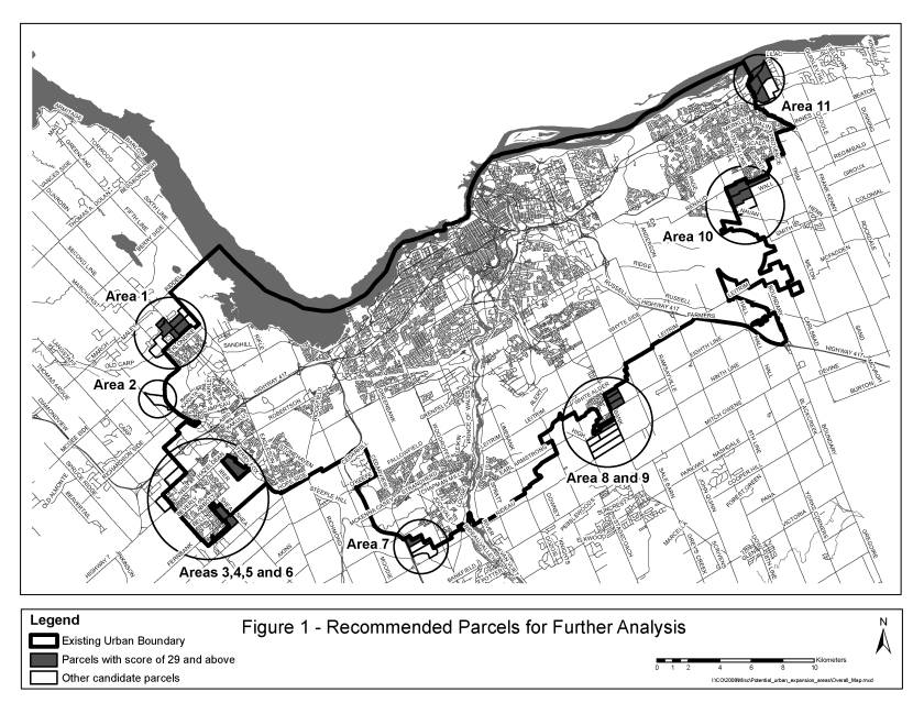
Figure 1 shows the areas achieving the highest points in the
preliminary. These include:
a.
Areas 1a, 1b, 1c, 1d, 1h north of Kanata
b.
(Areas 5a and 5b – no additional analysis required)
c.
Areas 6a, 6b and 6c south of Stittsville
d.
Area 7a south of South Nepean
e.
Areas 8a, 9a, 9b, 9c adjacent to Leitrim
f.
Areas 10a, 10b and 10d south of Orleans
g.
Areas 11a, 11b, 11c, 11e east of Orleans.
7.
Figure 1 should not be read as a list of recommended areas, since the
Phase 2 analysis may change the ranking significantly.
Recommendations
1.
The City will undertake some additional servicing analysis over the
next month to examine the serviceability of the preferred parcels. In particular, the analysis will review all
of the servicing studies submitted to date in addition to considering the
cumulative effect of urban land additions and economies of scale. This will provide a basis for revisions to
the decision rules, the scoring criteria and actual scores for the
infrastructure component of the analysis if appropriate.
2.
At least two weeks prior to the public meeting on March 31, staff will
provide an Official Plan Schedule indicating the recommended locations for
urban expansion based on the revisions made through the servicing analysis.
3.
The recommendations made at that time will also indicate what servicing
issues need to be addressed prior to development occurring on these parcels.
4.
City staff will arrange to get more accurate mapping of Natural
Heritage Features. The report prepared
for March 31 public meeting will indicate how these lands are to be secured by
the City.
5.
Areas 5a and 5b were included in the analysis for the Fernbank
community design plan and their servicing has been incorporated into the master
servicing study for Fernbank.
Therefore, no additional analysis is required for these two parcels.
Annex 1 –
Evaluation of Candidate Areas
|
Location Northern extension of the Kanata urban area on either side of March
Road. Part of Lot 12, Concessions II,
II and IV, March |
OP Designation: General Rural Area. |
Current Land Use(s): Primarily farms and forested areas. Some pockets of rural development within the study
area. The Ottawa Central Rail Road
line runs north-south through the eastern portion of parcels b and c while
Shirley’s Brook runs north-south through the western portion of b and c. |
|
Size: Gross ha = 349 Gross developable ha = 303 |
Zoning: RU – Rural Countryside |
|
|
Planning Status Part of 1e is within an OPA application from Richcraft Group of
Companies. |
Adjacent Land-Use designations: North:
General Rural
East: Greenbelt Rural South: General Urban Area West: Natural Environment
Area |
Adjacent Land Use(s): to the south is Urban Kanata, primarily
residential uses. To the west are the
South March Highlands. To the north
is more countryside. To the east is
the Greenbelt. Three existing areas
of rural development are located within or adjacent to the study area. |
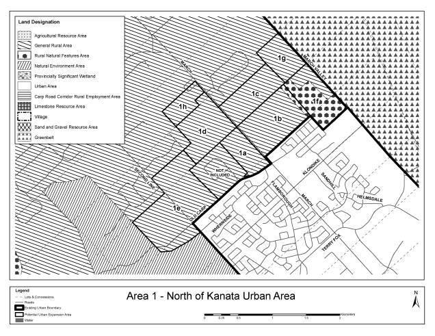
Natural Heritage System
General Comment
|
The area is bounded by the South March
Highlands (Natural Environment Area) on the west and the Greenbelt on the
East. While there are some small
vestiges of forested land, most of the area is old fields and hedgerows. No obvious soil problems are evident.
|
||||
Area Comments
|
Gross Ha
|
Natural Heritage System Feature
|
NHS Removed
|
Other Constraints
|
Gross Developable Ha
|
1a
|
24.4
|
|
|
1.0 ha floodplain
|
23.4
|
1b
|
56.7
|
|
|
2.0 ha floodplain |
54.7
|
1c
|
38.7
|
|
|
2.0 ha floodplain |
36.7
|
1d
|
46.2
|
|
|
|
46.2
|
1e
|
95.6
|
Woodland
|
27.0
|
|
68.6
|
1f
|
42.1
|
Woodland
|
5.0
|
3.0 ha floodplain
|
34.1
|
1g
|
26.6
|
|
|
3.0 ha floodplain
|
23.6
|
1h
|
18.2
|
|
|
Removed church and cemetery 2.6 ha
|
15.6
|
Total
|
348.6
|
|
27.0
|
13.6
|
302.9
|
Servicability
|
Servicability – water |
The water supply to this area is good. The land above elevation 90m,
which is most of the area west of March Rd., needs to be serviced through the
existing Morgan’s Grant Pump Station to maintain satisfactory pressures. This
requires upgrades to the pump station and suction pipes. |
|
Servicability – wastewater |
Two trunk sewers service this area. Only the East March Trunk (near
Terry Fox east of March Rd.) has any residual capacity. This residual would
service about 1900 units. Upgrades could provide for up to 3400 units. The
second trunk (Hines Rd. sewer) may require upgrades in the future to
accommodate growth in the Village of Carp and represents an opportunity for the
future for capacity creation for additional development. |
|
Servicability – stormwater and natural hazards |
Shirley’s Brook subwatershed plan would require updating to guide
development. Some floodplain constraints exist in parcels east of March Road.
Parcels west of March Road may have areas where overburden is shallow
(blasting may be required to service). No significant drainage constraints
exist that could not be overcome with application of conventional engineering
methods. |
Accessibility
Area
|
Access to Arterial Roads
|
Distance to Future Rapid
Transit (km)
|
1a
|
March Road
|
0
|
1b
|
March Road |
0
|
1c
|
March Road |
0.6
|
1d
|
March Road |
0.74
|
1e
|
None
|
1.0
|
1f
|
None
|
0.9
|
1g
|
None
|
1.5
|
1h
|
March Road
|
1.5
|
Area
|
Connectivity
|
Distance to
Mainstreet or MUC (approx km)
|
Jobs/Housing
Balance
|
1a
|
Medium
– from March Rd but not to community in south
|
7
|
Improved
|
1b
|
Medium
– from March Rd but not to community in south
|
7
|
Improved
|
1c
|
Medium
– rural subdivision to the north
|
8
|
Improved
|
1d
|
Medium
– partly blocked in south (country lots) and in west (country lots)
|
8
|
Improved
|
1e
|
Poor
– NEA to west, country lots to east and north. But connects to Old Carp Road and Second Line Road
|
8
|
Improved
|
1f
|
Poor
– Rail on west and greenbelt on east and rural natural feature to south
|
8
|
Improved
|
1g
|
Poor
– Rail on west and greenbelt on east and rural natural feature to south
|
9
|
Improved
|
1h
|
Medium
– good connection to South could be accomplished but Church and cemetery
barriers on the east
|
8.8
|
Improved
|
Integration with Community (cont’d)
Area
|
Distance to
Facilities (km)
|
||
Proposed Kanata
North Recreation Centre (Innovation Drive)
|
Kanata Leisure
Centre and wave Pool
|
J Mlacak Centre
and Art Gallery
|
|
1a
|
2.1
|
7.1
|
6.5
|
1b
|
2.2
|
7.2
|
6.6
|
1c
|
2.8
|
7.8
|
7.2
|
1d
|
2.8
|
7.8
|
7.2
|
1e
|
3.1
|
8.1
|
7.5
|
1f
|
3.1
|
8.1
|
7.5
|
1g
|
3.7
|
8.7
|
8.1
|
1h
|
3.6
|
8.6
|
8.0
|
Integration with Community (cont’d)
Area
|
Distance to
Facilities (km)
|
|||
Old March Town
Hall
|
Library
|
Police
|
Fire Station 45
|
|
1a
|
0.4
|
6.5
|
8.3
|
2.1
|
1b
|
0.5
|
6.6
|
8.4
|
2.1
|
1c
|
1.1
|
7.2
|
9.0
|
1.7
|
1d
|
1.1
|
7.2
|
9.0
|
1.4
|
1e
|
1.4
|
7.5
|
9.3
|
2.8
|
1f
|
1.4
|
7.5
|
9.3
|
3.0
|
1g
|
2.0
|
8.1
|
9.9
|
2.6
|
1h
|
1.9
|
8.0
|
9.8
|
0.5
|
Potential Conflicting Land Uses
Area
|
Ha Agricultural
Resource Area within 500 metres
|
Ha Aggregate
Resources within 500 metres
|
Ha Landfills
within 500 metres
|
Country Lot and
Village Development
|
1a
|
0
|
0
|
0
|
Marchbrook Circle
|
1b
|
0
|
0
|
0
|
None
|
1c
|
0
|
0
|
0
|
Hedge Drive
|
1d
|
0
|
0
|
0
|
Marchbrook Circle and Nadia
|
1e
|
0
|
0
|
2.6 (former Kanata-1)
|
Marchbrook Circle and Thomas Fuller
|
1f
|
0
|
0
|
0
|
None
|
1g
|
0
|
0
|
0
|
Hedge Drive
|
1h
|
0
|
0
|
0
|
Wildacre
|
Depth to Bedrock
Area
|
Depth of
Overburden
(metres) |
1a
|
2 to 3
|
1b
|
2 to 3
|
1c
|
2 to 3
|
1d
|
2 to 3
|
1e
|
2 to 3
|
1f
|
2 to 3
|
1g
|
2 to 3
|
|
Location West of the alignment of the future Terry Fox Drive extension |
OP Designation: General Rural Area |
Current Land Use(s): Undeveloped scrub land |
|
Size: Gross ha = 79 Gross developable ha = 51 |
Zoning: RU – Rural Countryside |
|
|
Planning Status Richcraft Group of Companies has submitted an Official Plan Amendment
Application that includes these lands. |
Adjacent Land-Use designations: South and West: Agricultural
Resource Area East: Urban Area North: Natural Environment
Area. |
Adjacent Land Use(s): Huntmar Drive to the west, Carp River to
the South, future Terry Fox alignment to the east and South March Highlands
to the north. |
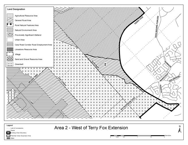
Natural Heritage System
General Comment
|
Bounded on the north by an NEA (South March
Highlands) and Agricultural to the south.
Bounded by Carp River to the south
No organic soils or indicators of Leda Clay
|
||||
Area Comments
|
Gross Ha
|
Natural Heritage System
Feature
|
NHS Removed
|
Other Constraints
|
Gross Developable Ha
|
2
|
79.0
|
Escarpment
|
1.0
|
27.0 ha Carp River floodplain |
51.0
|
Servicability
|
Servicability – water |
Service from extension (if possible ) of Broughton water. |
|
Servicability – wastewater |
There is no single nearby local sanitary sewer with spare capacity.
The nearest trunk sewer is the Kanata Lakes Trunk, some 4 km away. |
|
Servicability – stormwater and natural hazards |
There would be a need to update the impact assessment for the Carp
River. The lands are generally flat and have poor drainage. Stormwater
management may be challenging because of the mild slopes and outlet
constraints. |
Accessibility
Area
|
Access to
Arterial Roads
|
Distance to
Town Centre Rapid Transit (km)
|
2
|
Would have access to a future extension of
Terry Fox Drive
|
4.1
|
Area
|
Connectivity
|
Distance to
Mainstreet or MUC (approx km)
|
Jobs/Housing
Balance
|
2
|
Medium
–Connectivity to future Terry Fox Drive and Huntmar Road. No other development on that side of road.
|
4.0
|
improved
|
Integration with Community (cont’d)
Area
|
Distance to
Facilities (km)
|
||
Proposed Kanata
North Recreation Centre (Innovation Drive)
|
Kanata Leisure
Centre and Wave Pool
|
J Mlacak Centre
and Art Gallery
|
|
2
|
3.5
|
5.6
|
6
|
Integration with Community (cont’d)
Area
|
Distance to
Facilities (km)
|
|||
Old March Town
Hall
|
Library
|
Police
|
Fire Station
Teron Road
|
|
2
|
n.a.
|
6
|
4.3 (new station)
|
4.3
|
Potential Conflicting Land Uses
Area
|
Ha Agricultural
Resource Area within 500 metres
|
Ha Aggregate
Resources within 500metres
|
Ha Landfills
within 500 metres
|
Country Lot and
Village Development
|
2
|
117
|
0
|
0
|
none
|
Depth to Bedrock
Area
|
Depth of
Overburden (metres)
|
2
|
2 to 3
|
|
Location: North of Stittsville urban boundary, west of Kanata West urban
boundary, south of Hwy 417 and three lots east of Carp Road |
OP Designation: Rural Natural Feature |
Current Land Use(s): Vacant Forest |
|
Size: Gross ha = 79 Gross developable ha = 79 |
Zoning: RU – Rural Countryside |
|
|
Planning Status: -no active application -subject of an appeal on the 2003 Official Plan urban boundary |
Adjacent Land-Use designations: South and East: Urban West: Carp Road North: Rural Natural Feature |
Adjacent Land Use(s): -Vacant to North -Residential in South -Planned employment in East -Residential along Carp Rd in west |
Natural Heritage System
General Comment
|
The parcel is designated as rural natural feature. Vegetation has been cleared from the
property, therefore, there are no natural heritage system features. |
||||
Area Comments
|
Gross Ha
|
Natural Heritage System
Feature
|
NHS Removed
|
Other Constraints
|
Gross Developable Ha
|
3
|
79.0
|
|
0
|
0
|
79.0
|
Servicability
|
Servicability – water |
The watermain on Carp Rd. could service a portion of this area near
Carp Rd. The remaining land needs to be in a different pressure zone and
would best be serviced through future Kanata West and existing Stittsville
watermains. |
|
Servicability – wastewater |
There are no sewers in the vicinity with excess capacity. The
Stittsville Trunk sewer could have residual capacity but it is about 4 km
south of this site. The preferred solution would be to provide capacity in
the Kanata West sewer system. |
|
Servicability – stormwater and natural hazards |
Drains to Feedmill Creek (within Carp River watershed). Existing
studies would require updating; some areas of shallow overburden (blasting
may be required to service). |
Accessibility
Area
|
Access to Arterial Roads
|
Distance to Future Rapid
Transit (km)
|
3
|
Direct Access to Carp Road
|
4.3
|
Area
|
Connectivity
|
Distance to
Mainstreet or MUC (approx km)
|
Jobs/Housing
Balance
|
3
|
Poor
– closed portion of Rothbourne Road allowance, limitations on crossings of
Feedmill Creek and existing Lloydalex Cr. limit access
|
1.7
|
improved
|
Area
|
Distance to
Facilities (km)
|
||
Goulbourn
Recreation Complex
|
Walter Baker
Park and Kanata Rec Centre and Theatre
|
Stittsville
Community Centre
|
|
3
|
4.0
|
5.6
|
2.7
|
Area
|
Distance to
Facilities (km)
|
||
Library
|
Police
|
Fire Station 81
|
|
3
|
4.0
|
7.4
|
4.0
|
Area
|
Ha Agricultural
Resource Area within 500 metres
|
Ha Aggregate
Resources within 500metres
|
Ha Landfills
within 500 metres
|
Country Lot and
Village Development
|
3
|
0
|
0
|
0
|
Rural street within block
|
Depth to Bedrock
Area
|
Depth of
Overburden
(metres) |
3
|
2 to 3
|
|
Location West of Stittsville, north of Hazeldean Road |
OP Designation: General Rural Area |
Current Land Use(s): Fields, forest, one residential use |
|
Size: Gross ha = 59 Gross developable ha = 45 |
Zoning: RU – Rural Countryside |
|
|
Planning Status No application |
Adjacent Land-Use designations: North: Carp Road West: General Rural South: Rural Natural Feature
East: Urban Area. |
Adjacent Land Use(s): Residential to the east, forested to the south, forest and farm to
west and mineral resource to the north. |

Natural Heritage System
General Comment
|
The land parcel is situated at the
northwestern edge of Stittsville, south of Rothbourne Road. The land parcel is adjacent to the
Goulbourn Wetland Complex. The land
contains 14 ha of woodlands.
|
||||
Area Comments
|
Gross Ha
|
Natural Heritage System
Feature
|
NHS Removed
|
Other Constraints
|
Gross Developable Ha
|
4
|
59.0
|
Woodland
|
17.0
|
2.3 (hydro r-o-w)
|
39.7
|
Servicability
|
Servicability – water |
This is part of future Stittsville Pressure Zone. Some pipe extension
will be required from the existing water pipe on Hazeldean Rd. and the future
Stittsville pump Station will require pump upgrades. |
|
Servicability – wastewater |
There are no sewers in the vicinity with excess capacity. The
Stittsville Trunk sewer could have residual capacity but it is about 3.5 km
south of this site. Flow monitoring of the existing sewer system might
provide some opportunities to use existing infrastructure for a portion of
this site. The Master Servicing for Kanata West can be reviewed there is an
opportunity to consider a pump
station and forcemain to access future sewers in Kanata West. |
|
Servicability – stormwater and natural hazards |
Drains to Feedmill Creek (within Carp River watershed). Drainage of
Area 4 may be challenging because of constraints created by the existing
Timbermere subdivision to the east. Existing studies would require updating;
some areas of shallow overburden (blasting may be required to service). |
Accessibility
Area
|
Access to Arterial Roads
|
Distance to Future Rapid
Transit (km)
|
4
|
Direct Access to Hazeldean Rd
|
4.4
|
Area
|
Connectivity
|
Distance to
Mainstreet or MUC (approx km)
|
Jobs/Housing
Balance
|
4
|
Poor
- Not well connected to existing development
|
1.5
|
improved
|
Area
|
Distance to
Facilities (km)
|
||
Goulbourn
Recreation Complex
|
Walter Baker
Park and Kanata Rec Centre and Theatre
|
Stittsville
Community Centre
|
|
4
|
3.9
|
5.4
|
3.0
|
Area
|
Distance to
Facilities (km)
|
||
Stittsville
Library
|
Police
|
Fire Station 81
|
|
4
|
4.3
|
7.3
|
4.3
|
Area
|
Ha Agricultural
Resource Area within 500 metres
|
Ha Aggregate
Resources within 500 metres
|
Ha Landfills
within 500 metres
|
Country Lot and
Village Development
|
4
|
0
|
9.0
|
0
|
None adjacent
|
Depth to Bedrock
Area
|
Depth of
Overburden
(metres) |
4
|
2 to 3
|
|
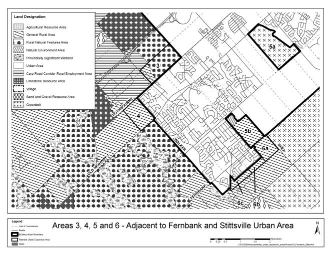
Location Two parcels within the study area of the Fernbank Estates community
design plan. |
OP Designation: Agricultural Resource Area and General Rural Area |
Current Land Use(s): 5a is farmed 5b is partially tree covered |
|
Size: Gross ha = 183 Gross developable ha = 163 |
Zoning: AG – Agricultural RU – Rural Countryside |
|
|
Planning Status Has been included in the Fernbank community design plan. Part of 5a is the subject of an OPA application from Richcraft Group
of Companies |
Adjacent Land-Use designations: Urban Area and Future Urban Area.
5b also has General Rural Area to the south. |
Adjacent Land Use(s): 5a is surrounded by Fernbank Future Urban Area and 5b is adjacent to
Fernbank in the west, the Sacred Heart High School and Goulbourn Recreation
Complex in the north, Stittsville Urban Area in the east and rural
undeveloped land to the south. |

Natural Heritage System
General Comment
|
5a and 5b are situated adjacent to Fernbank
lands already included inside the urban boundary. 5a abuts the Carp River, whereas 5b is located southwest of
Sacred Heart High School. 5b is 10%
organic soils
|
||||
Area Comments
|
Gross Ha
|
Natural Heritage System
Feature
|
NHS Removed
|
Other Constraints
|
Gross Developable Ha
|
5a
|
114.2
|
|
|
9 ha
floodplain
|
105.2
|
5b
|
68.7
|
Woodland
|
10.0
|
1 ha (hydro r-o-w)
|
57.7
|
Total
|
182.9
|
|
10.0
|
|
162.9
|
Servicability
|
Servicability – water |
This area is included in the Fernbank CDP and servicing could be
easily integrated with future development. |
|
Servicability – wastewater |
This area is included in the Fernbank CDP and servicing could be
easily integrated with future development. Upgrades to the Hazeldean Pump
Station will be needed before these areas can proceed. These upgrades will
also be required for full development of Fernbank. |
|
Servicability – stormwater and natural hazards |
Area 5a is in the Carp River watershed area 5b is part of the Jock
River watershed. Drainage of these lands has been considered in the Fernbank
CDP EMP, which is nearing completion. Drainage / stormwater management of the
alternative sites is reasonably straightforward using conventional
engineering methods. |
Accessibility
Area
|
Access to Arterial Roads
|
Distance to Future Rapid
Transit (km)
|
5a
|
Direct access to Hazeldean Road
|
0
|
5b
|
Direct Access to Fernbank
|
2.2
|
Area
|
Connectivity
|
Distance to
Mainstreet or MUC (approx km)
|
Jobs/Housing
Balance
|
5a
|
Medium
connectivity- hydro corridor and trans Canada trail intersect. Carp River borders part of site
|
0 – Hazeldean Rd.
|
Improved
|
5b
|
Medium
connectivity -Trans Canada trail
|
0.6 Stittsville Mainstreet
|
Improved
|
Area
|
Distance to
Facilities (km)
|
||
Goulbourn
Recreation Complex
|
Walter Baker
Park and Kanata Rec Centre and Theatre
|
Stittsville
Community Centre
|
|
5a
|
2.2
|
0.7
|
4.1
|
5b
|
0.1
|
4.8
|
1.2
|
Area
|
Distance to
Facilities (km)
|
||
Library
|
Police
|
Fire Station 81
|
|
5a
|
2.2 (Hazeldean Library)
|
3.0
|
2.0 (#41)
|
5b
|
1.28
|
5.6
|
1.28
|
Area
|
Ha Agricultural
Resource Area within 500 metres
|
Ha Aggregate
Resources within 500 metres
|
Ha Landfills
within 500 metres
|
Country Lot and
Village Development
|
5a
|
0
|
0
|
0
|
None
|
5b
|
13
|
0
|
0
|
none
|
Depth to Bedrock
Area
|
Depth of
Overburden
(metres) |
5a
|
5 to 10
|
5b
|
0 to 2
|
|
Location South of Stittsville Urban Area and south of area 5b |
OP Designation: General Rural Area |
Current Land Use(s): 6c is cleared for development and the rest is scrub and old fields. |
|
Size: Gross ha = 72 Gross developable ha = 66 |
Zoning: RU – Rural Countryside |
|
|
Planning Status Ray Bell has an active Country Lot Subdivision application on Area 6c
and has an active application for an urban expansion |
Adjacent Land-Use designations: North: Urban Area and Future
Urban Area East: Agricultural Resource
Area South: Agriculture Resource
Area and General Rural Area West: General Rural Area |
Adjacent Land Use(s): South of 6c is a Country Lot Subdivision, Stittsville residential is
to the north and Agriculture is to the east. |

Natural Heritage System
General Comment
|
Located southwest of the urban boundary in
Stittsville, these parcels are situated amongst residential development, idle
and active agriculture.
|
||||
Area Comments
|
Gross Ha
|
Natural Heritage System
Feature
|
NHS Removed
|
Other Constraints
|
Gross Developable Ha
|
6a
|
39.6
|
|
|
6.0 (hydro r-o-w)
|
33.6
|
6b
|
12.3
|
|
|
|
12.3
|
6c
|
19.8
|
|
|
|
19.8
|
Total
|
71.7
|
|
|
6.0
|
65.7
|
Servicability
|
Servicability – water |
This area straddles 2 pressure zones. Area 6c and a portion of 6b
could be serviced through the existing infrastructure. The remaining area
would need to be serviced through the future infrastructure in Fernbank. |
|
Servicability – wastewater |
The existing Stittsville Sanitary Pump Station and downstream sewers
are the closest outlet for this area but have little residual capacity.
Further investigation and monitoring might identify some opportunities. The
most certain potential is to make provision for sewer capacity in Fernbank or
access the Stittsville Trunk Sewer about 2.5 Km away. |
|
Servicability – stormwater and natural hazards |
The Area 6 alternative sites fall within the Jock River Reach 2
subwatershed. The existing subwatershed study and/or Fernbank EMP would
require updating/expansion for southerly parcels. All alternatives sites have
little or no drainage constraints. Drainage / stormwater management of the
alternative sites is reasonably straightforward using conventional
engineering methods. |
Accessibility
Area
|
Access to Arterial Roads
|
Distance to Future Rapid
Transit (km)
|
6a
|
Fernbank Rd
|
1.9
|
6b
|
No
|
2.9
|
6c
|
Stittsville Main St
|
3.6
|
Area
|
Connectivity
|
Distance to
Mainstreet or MUC (approx km)
|
Jobs/Housing
Balance
|
|
6a
|
Good
|
1.7
|
Improved
|
|
6b
|
Good
|
2.0
|
Improved
|
|
6c
|
Medium – country lot to south
|
1.3
|
Improved
|
|
Area
|
Distance to
Facilities (km)
|
|||
Goulbourn
Recreation Complex
|
Walter Baker
Park and Kanata Rec Centre and Theatre
|
Stittsville
Community Centre
|
||
6a
|
0.8
|
5.9
|
3.1
|
|
6b
|
2.1
|
7.2
|
3.4
|
|
6c
|
2.8
|
7.8
|
2.6
|
|
Area
|
Distance to
Facilities (km)
|
|||
Library
|
Police
|
Fire Station 81
|
||
6a
|
1.8
|
6.3
|
1.8
|
|
6b
|
2.1
|
7.6
|
2.1
|
|
6c
|
1.3
|
8.2
|
1.3
|
|
Area
|
Ha Agricultural
Resource Area within 500 metres
|
Ha Aggregate
Resources within 500 metres
|
Ha Landfills
within 500 metres
|
Country Lot and
Village Development
|
|
6a
|
53.0
|
0
|
0
|
None
|
|
6b
|
0
|
0
|
0
|
Rural subdivision adjacent
|
|
6c
|
0
|
0
|
0
|
Rural subdivision adjacent
|
|
Area
|
Depth of
Overburden
(metres) |
6a
|
2 to 3
|
6b
|
3 to 5
|
6c
|
0 to 2
|
|
Location East of HWY 416 south of the urban boundary |
OP Designation: Sand and Gravel Resource Area |
Current Land Use(s): Primarily mineral extraction. Agriculture |
|
Size: Gross ha = 168 Gross developable ha = 168 |
Zoning: MR – Mineral Aggregate Reserve ME – Mineral Extraction |
|
|
Planning Status Official Plan Amendment Application submitted by Minto Communities
for a larger area. |
Adjacent Land-Use designations: North and East: Urban Area South: Agriculture Resource
Area West: General Rural Area |
Adjacent Land Use(s): Currently undeveloped to the north, Agriculture to the east and south
and mineral extraction and waste disposal to the west. |
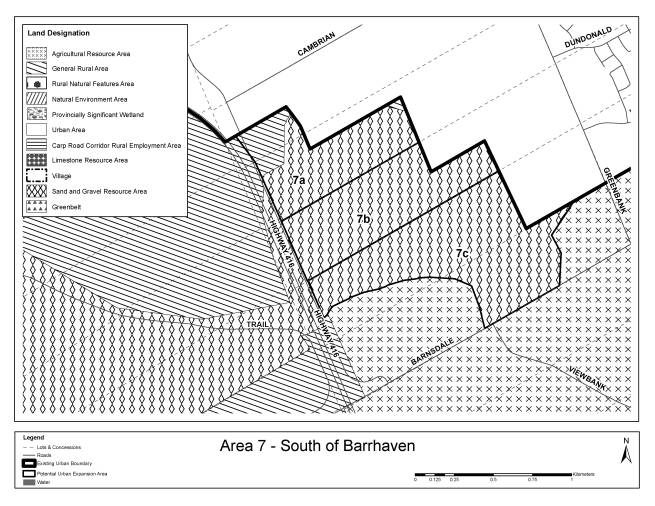
Natural Heritage System
General Comment
|
Located south of Barrhaven and east of Highway 416, these parcels are
adjacent to sand and gravel resource area.
There are no natural heritage system features located on these lands. |
||||
Area Comments
|
Gross Ha
|
Natural Heritage System Feature
|
NHS Removed
|
Other Constraints
|
Gross Developable Ha
|
7a
|
42.8
|
|
|
|
42.8
|
7b
|
50.4
|
|
|
|
50.4
|
7c
|
74.9
|
|
|
|
74.9
|
Total
|
168.2
|
|
|
|
168.2
|
Servicability
|
Servicability – water |
Water would need to be provided from Cambrian Rd and from Greenbank
Rd. There is still some opportunity to oversize these watermains and any
additional future pipes in Barrhaven South to provide the necessary capacity. Higher elevations could require booster pumping station or be zoned
open space. |
|
Servicability – wastewater |
The South Nepean Collector (a continuation of the West Rideau
Collector) and the West Rideau Collector is limited to about 1900 to 2200
units. This is a small number relative to the sewer capacity. As this
capacity could easily be taken up by existing planned development there will
need be a requirement to divert some sanitary flow in Barrhaven to the
Greenbank Road trunk in order to offset the servicing needs for these areas. Servicing plans in Barrhaven South near Cambrian Road are too far
advanced to change to accommodate growth areas. A future trunk sewer will be
required on Greenbank and could still be sized to provide capacity for all or
part of this area. |
|
Servicability – stormwater and natural hazards |
Area is in the Jock River watershed.
The subwatershed plan and/or the Barrhaven South Master Servicing Plan
would need updating. The incremental impact of Area 7a on drainage
constraints in Barrhaven South may be manageable, however, the cumulative impact
of drainage from Areas 7a, 7b, and 7c would be challenging given the
constraints in storm drainage systems planned and built in Barrhaven South. |
Accessibility
Area
|
Access to Arterial Roads
|
Distance to Future Rapid
Transit (km)
|
7a
|
New Re-aligned Greenbank
|
0.9
|
7b
|
New Re-aligned Greenbank
|
1.2
|
7c
|
Barnsdale
|
1.5
|
Area
|
Connectivity
|
Distance to
Mainstreet or MUC (approx km)
|
Jobs/Housing
Balance
|
|
7a
|
Good - Can easily be well planned
|
2
|
Slightly below
|
|
7b
|
Good - Can easily be well planned
|
2
|
Slightly below
|
|
7c
|
Good - Can easily be well planned
|
2
|
Insufficient
|
|
Area
|
Distance to
Facilities (km)
|
||
Walter Baker
Sports Centre
|
South Barrhaven
Recreation Complex (planned)
|
||
7a
|
5.5
|
1.9
|
|
7b
|
5.9
|
1.9
|
|
7c
|
6.5
|
1.5
|
|
Area
|
Distance to
Facilities (km)
|
|||
Library
|
Police
|
Fire Station 44
|
||
7a
|
5.5
|
5.5
|
4.5
|
|
7b
|
5.9
|
5.9
|
4.7
|
|
7c
|
6.0 (Manotick)
|
6.5
|
5.3
|
|
Area
|
Ha Agricultural
Resource Area within 500 metres
|
Ha Aggregate
Resources within 500 metres
|
Ha Landfills
within 500 metres
|
Country Lot and
Village Development
|
|
7a
|
0
|
0
|
16.0
|
No
|
|
7b
|
13.0
|
6.0
|
16.0
|
No
|
|
7c
|
132.0
|
13.0
|
16.0
|
No
|
|
Area
|
Depth of
Overburden
(metres) |
7a
|
15 to 25
|
7b
|
15 to 25
|
7c
|
15 to 25
|
|
Location South of Leitrim Urban Area |
OP Designation: General Rural Area and some Sand and Gravel Resource Area |
Current Land Use(s): Scrub Racetrack |
|
Size: Gross ha = 308 Gross developable ha = 170 |
Zoning: RU: Rural Countryside RC4: Rural Commercial (racetrack) ME: Mineral Extraction |
|
|
Planning Status OPA application from Richcraft Group of Companies includes part of
Area 8c. |
Adjacent Land-Use designations: South: Sand and Gravel
Resource Area North: Urban Area East: Limestone Resource Area
and General Rural Area West: Sand and Gravel
Resource Area |
Adjacent Land Use(s): South: sand and gravel North: under development
(residential) East: Quarry West: Idle, golf course,
potential future location of CCE. |
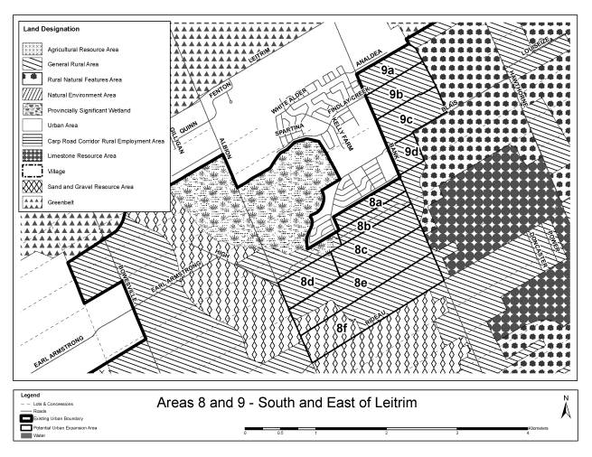
Natural Heritage System
General Comment
|
Located south of Leitrim, these lands are
adjacent to the Provincially Significant Casino Wetland. In particular, parcels 8b, 8c and 8d have
included wetland . Woodlands are also present on 8c, 8e and 8f.
|
||||
Area Comments
|
Gross Ha
|
Natural Heritage System Feature
|
NHS Removed
|
Other Constraints
|
Gross Developable Ha
|
8a
|
22.5
|
|
|
|
22.5
|
8b
|
22.7
|
Casino Wetland
|
1.0
|
|
21.7
|
8c
|
48.2
|
3.0 Wetland and
14.0 Woodland |
17.0
|
|
31.2
|
8d
|
33.7
|
Casino Wetland
|
3.0
|
|
30.7
|
8e
|
87.8
|
Woodland
|
26.0
|
Setbacks from Mineral Resource Area
|
23.8
|
8f
|
93.0
|
Woodland
|
3.0
|
Setbacks from Mineral Resource Area
|
40.0
|
Total
|
307.9
|
|
40.0
|
|
169.9
|
Servicability
|
Servicability – water |
The principal water supply to this area is through an existing
watermain on Bank St. and through a future pipe on Kelly Farm Road (Findley
Creek development). Areas 8a and 8b could be serviced by extension of
proposed infrastructure. The remaining areas would need to be supplied from
the Russell PS as the normal water pressures would be too low. This would
require upgrades to a pump station and watermain that are dedicated supply
water to Russell. |
|
Servicability – wastewater |
The principal outlet sewers to the area are the Conroy Road sewer and
the downstream Green Creek Collector. Both have no capacity to service
additional growth and would require upgrades or diversions to be useful. The
new Leitrim Pumping Station would also need pump upgrades. |
|
Servicability – stormwater and natural hazards |
All the parcels are in Findlay Creek watershed. No subwatershed plan
available to guide development. All alternatives sites have little or no
drainage constraints. Drainage / stormwater management of the alternative
sites is reasonably straightforward using conventional engineering methods. |
Accessibility
Area
|
Access to Arterial Roads
|
Distance to Future Rapid
Transit (Light Rail to Riverside South)
|
8a
|
Bank St
|
5.6
|
8b
|
Bank St
|
5.8
|
8c
|
Bank St and maybe new Strandherd-Armstrong link
|
4.9
|
8d
|
Albion Rd and maybe new Strandherd-Armstrong link
|
3.9
|
8e
|
Albion Rd and Bank St and maybe new
Strandherd-Armstrong link
|
4.4
|
8f
|
Bank St, Albion Rd, Rideau Rd.
|
4.9
|
Area
|
Connectivity
|
Distance to
Mainstreet or MUC (approx km)
|
Jobs/Housing
Balance
|
||
8a
|
Good - Can be designed to have good connectivity
|
4.7
|
Meets
|
||
8b
|
Good - Can be designed to have good connectivity
|
4.9
|
Slightly below
|
||
8c
|
Good - Can be designed to have good connectivity
|
5.1
|
Insufficient
|
||
8d
|
Good - Can be designed to have good connectivity
|
6.3
|
Insufficient
|
||
8e
|
Good - Can be designed to have good connectivity
|
5.6
|
Insufficient
|
||
8f
|
Good - Can be designed to have good connectivity
|
6.1
|
Insufficient
|
||
Area
|
Distance to
Facilities (km)
|
||
Gloucester
South Community Centre
|
Fred Barrett
Arena
|
||
8a
|
2.5
|
2.5
|
|
8b
|
2.7
|
2.7
|
|
8c
|
2.9
|
2.9
|
|
8d
|
4.2
|
4.2
|
|
8e
|
3.4
|
3.4
|
|
8f
|
3.5
|
3.5
|
|
Area
|
Distance to
Facilities (km)
|
|||
Library
(Blossom Park)
|
Police
|
Fire Station 32
|
||
8a
|
4.7
|
2.5
|
2.5
|
|
8b
|
4.9
|
2.7
|
2.7
|
|
8c
|
5.1
|
2.9
|
2.9
|
|
8d
|
6.3
|
4.2
|
4.2
|
|
8e
|
5.6
|
3.4
|
3.4
|
|
8f
|
5.7
|
3.5
|
3.5
|
|
Area
|
Ha Agricultural
Resource Area within 500 metres
|
Ha Aggregate
Resources within 500 metres
|
Ha Landfills
within 500 metres
|
Country Lot and
Village Development
|
|
8a
|
0
|
0
|
0
|
None
|
|
8b
|
0
|
4
|
0
|
None
|
|
8c
|
0
|
17.0
|
0
|
None
|
|
8d
|
0
|
70.0
|
0
|
Racetrack
|
|
8e
|
0
|
76.0
|
0
|
Racetrack
|
|
8f
|
0
|
156.0
|
0
|
None
|
|
Area
|
Depth of
Overburden
(metres) |
8a
|
2 to 3
|
8b
|
2 to 3
|
8c
|
3 to 5
|
8d
|
10 to 15
|
8e
|
3 to 5
|
8f
|
?
|
|
Location East of Leitrim, east of Bank Street. |
OP Designation: General Rural Area |
Current Land Use(s): Scrub Some rural industrial uses |
|
Size: Gross ha = 124 Gross developable ha = 118 |
Zoning: RU: Rural Countryside |
|
|
Planning Status No active applications |
Adjacent Land-Use designations: North: Urban Area South and East: Rural Natural
Feature West: Urban Area |
Adjacent Land Use(s): Urban residential development to the north and west. Forest to the east. Quarries to the south |
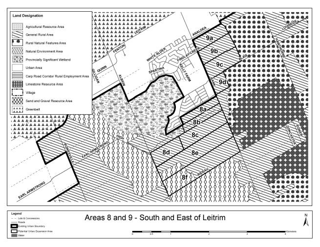
Natural Heritage System
General Comment
|
Situated east of Leitrim and east of Bank
Street, these parcels are adjacent to a rural natural feature. 9c and 9d contain woodlands.
|
||||
Area Comments
|
Gross Ha
|
Natural Heritage System
Feature
|
NHS Removed
|
Other Constraints
|
Gross Developable Ha
|
9a
|
29.6
|
|
|
|
29.6
|
9b
|
36.3
|
|
|
|
36.3
|
9c
|
40.4
|
Woodland
|
3.0
|
|
37.4
|
9d
|
17.4
|
Woodland
|
3.0
|
|
14.4
|
Total
|
123.7
|
|
6.0
|
|
117.7
|
Servicability
|
Servicability – water |
The principal water supply to this area is through an existing
watermain on Bank St. Planned watermains for Findley Creek development can
still be upsized to service this area. All the parcels will need to find
access to existing system for looping. The upgrades to the Ottawa South Pump Station would also need to
account for the increased demand. |
|
Servicability – wastewater |
The principal receiving sewers to the area are the Conroy Rd. sewer
and the downstream Green Creek Collector. Both have no capacity to service
additional growth and would require upgrades or diversions to be useful. The
new Leitrim Pumping Station would also need pump upgrades. |
|
Servicability – stormwater and natural hazards |
All the parcels are in Findlay Creek watershed. No subwatershed plan available to guide
development. With the exception of Area 9d, all alternative sites have little
or no drainage constraints. Drainage / stormwater management of sites 9a, 9b,
and 9c is reasonably straightforward using conventional engineering methods.
Area 9d is constrained by watercourses that cross the land with sizeable
external drainage areas. |
Accessibility
Area
|
Access to Arterial Roads
|
Distance to Future Rapid
Transit (km)
|
9a
|
Bank St
|
3.7
|
9b
|
Bank St |
4.0
|
9c
|
Bank St |
4.4
|
9d
|
Bank St |
4.8
|
Area
|
Connectivity
|
Distance to
Mainstreet or MUC (approx km)
|
Jobs/Housing
Balance
|
|
9a
|
Medium – not well connected to north
|
3.1
|
Meets
|
|
9b
|
Good - Can be planned with good connectivity
|
3.4
|
Insufficient
|
|
9c
|
Good - Can be planned with good connectivity
|
3.8
|
Insufficient
|
|
9d
|
Good - Can be planned with good connectivity
|
4.2
|
Insufficient
|
|
Area
|
Distance to
Facilities (km)
|
||
Gloucester
South Community Centre
|
Fred Barrett
Arena
|
||
9a
|
0.9
|
0.9
|
|
9b
|
1.2
|
1.2
|
|
9c
|
1.6
|
1.6
|
|
9d
|
2.0
|
2.0
|
|
Area
|
Distance to
Facilities (km)
|
|||
Library
(Blossom Park)
|
Police
|
Fire Station 32
|
||
9a
|
3.1
|
0.9
|
0.9
|
|
9b
|
3.4
|
1.2
|
1.2
|
|
9c
|
3.8
|
1.6
|
1.6
|
|
9d
|
4.2
|
2.0
|
2.0
|
|
Area
|
Ha Agricultural
Resource Area within 500 metres
|
Ha Aggregate
Resources within 500 metres
|
Ha Landfills
within 500 metres
|
Country Lot and
Village Development
|
|
9a
|
0
|
0
|
0
|
None
|
|
9b
|
0
|
0
|
0
|
None
|
|
9c
|
0
|
0
|
0
|
None
|
|
9d
|
0
|
1
|
0
|
None
|
|
Area
|
Depth of
Overburden
(metres) |
9a
|
3 to 5
|
9b
|
2 to 3
|
9c
|
2 to 3
|
9d
|
2 to 3
|
|
Location South of Orleans Urban area between Mer Bleue Road and Tenth Line
Road south to Notre Dame des Champs. |
OP Designation: General Rural Area and Village (Notre Dame des Champs) |
Current Land Use(s): Agriculture and Bush Strip development along major roads |
|
Size: Gross ha = 506 Gross developable ha = 409 |
Zoning: RU – Rural Countryside Village Zones |
|
|
Planning Status Mattamy has an application for urban expansion on parts of 10a and
10b No appeals of the 2003 Official Plan |
Adjacent Land-Use designations: General Urban Area to the west Agriculture Resource Area to the east |
Adjacent Land Use(s): Urban development to the northeast including stormwater management
pond. Scrub forest and agriculture in lands to be urbanized to the west. Agriculture to the east. |
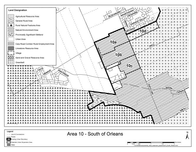
Natural Heritage System
General Comment
|
Area 10 is located south of Orleans.
10c contains woodlands. 10a
and 10b contain significant amounts of leda clay. |
||||
Area Comments
|
Gross Ha
|
Natural Heritage System
Feature
|
NHS Removed
|
Other Constraints
|
Gross Developable Ha
|
10a
|
88.7
|
|
|
10 (floodplain)
|
78.7
|
10b
|
88.8
|
|
|
4 (floodplain)
|
84.8
|
10c
|
88.6
|
Woodland
|
4.0
|
30.0 (Notre Dame des Champs excluded)
|
54.6
|
10d
|
42.1
|
|
|
|
42.1
|
Total
|
308.2
|
|
4.0
|
44.0
|
260.2
|
Servicability
|
Servicability – water |
Water supply is available from a watermain on Mer Bleue and through
an existing subdivision in Orleans at Tenth Line. Areas 10a ,10b, 10c would
require both sources to be used and interconnected. Area 10d would need only
a new pipe on 10th Line as long as it was possible to connect to
the adjacent existing infrastructure. |
|
Servicability – wastewater |
Area 10a, 10b and 10d have
ready access to the 10th Line Pump Station. The downstream sewer
has a capacity for approximately 9000 additional units. The pump station
would have to be upgraded to permit this additional load. Areas 10c, is better served by directing flows
through a new sewer to the Fourth Line PS ( Fourth Line at Page Rd) . Some
downstream sewer upgrades on the Forest Valley Trunk Sewer would be needed to
increase the available capacity from 1900 units. The Fourth Line Pump Station
would also need upgrades. |
|
Servicability – stormwater and natural hazards |
All the parcels are in the McKinnons Creek watershed. No subwatershed plan is available to guide
development. Area 10a is constrained by McKinnons Creek which bisects the
area, requiring two separate SWM facilities to service, and the area also
includes floodplain constraints.
Drainage of all sites is poor due to flat topography. Servicing the
area would require constructing a storm trunk outlet 1-2 km downstream of Mer
Bleue Road to establish a sufficient gravity outlet. Poor soils (Leda clay)
exist in some areas, and could limit potential to resolve HGL constraints by
filling alternative sites. |
Accessibility
Area
|
Access to Arterial Roads
|
Distance to Future Rapid
Transit (km)
|
10a
|
Mer Bleue and Tenth Line
|
1.0
|
10b
|
Tenth Line (Mer Bleue will become a collector Rd)
|
1.5
|
10c
|
Tenth Line
|
2.1
|
10d
|
Tenth Line
|
1.7
|
Area
|
Connectivity
|
Distance to
Mainstreet or MUC (approx km)
|
Jobs/Housing
Balance
|
10a
|
Good - Can be planned for connectivity
|
1.0
|
Insufficient
|
10b
|
Good - Can be planned for connectivity
|
1.5
|
Insufficient
|
10c
|
Good - Can be planned for connectivity
|
2.1
|
Insufficient
|
10d
|
Good - Can be planned for connectivity
|
1.7
|
Insufficient
|
Area
|
Distance to
Facilities (km)
|
||
Millennium
Sports Facility
|
Ray Friel
centre
|
Cumberland Arts
Centre
|
|
10a
|
4.5
|
3.0
|
5.0
|
10b
|
5.0
|
3.5
|
5.5
|
10c
|
5.6
|
4.1
|
6.1
|
10d
|
3.1
|
3.2
|
5.2
|
Area
|
Distance to
Facilities (km)
|
|
||||
Library
|
Police
|
Fire Station53
|
|
|||
10a
|
3.0
|
4.3
|
2.9
|
|||
10b
|
3.5
|
4.8
|
3.4
|
|||
10c
|
4.1
|
5.4
|
4.0
|
|||
10d
|
3.2
|
4.5
|
3.1
|
|||
Area
|
Ha Agricultural
Resource Area within 500 metres
|
Ha Aggregate
Resources within 500 metres
|
Ha Landfills
within 500 metres
|
Country Lot and
Village Development
|
10a
|
20.0
|
0
|
0
|
None
|
10b
|
55.0
|
0
|
0
|
Notre Dame des Champs
|
10c
|
70.0
|
0
|
0
|
Notre Dame des Champs
|
10d
|
113.0
|
0
|
0
|
None
|
Area
|
Depth of
Overburden
(metres) |
10a
|
25 to 50
|
10b
|
35 to 50
|
10c
|
15 to 25
|
10d
|
?
|
|
Location East of Cardinal Creek and the East boundary of
the Orleans Urban Area. |
OP Designation: General Rural
Area |
Current Land Use(s): agriculture, commercial nursery, boat
storage, scattered development. |
|
Size: Gross ha = 229 ha Gross developable ha = 144 ha |
Zoning: RU – Rural Countryside RI 5 – Rural Institutional RR1 – Rural Residential EP – along creek |
|
|
Planning Status No applications |
Adjacent Land-Use designations: Urban Area in the west; Rural Natural Feature in the south, and
General Rural Area in the east. |
Adjacent Land Use(s): Cardinal Creek on the west Ottawa River on the north Country lot subdivision on the east Wooded area in the south |
Natural Heritage System
General Comment
|
Situated along the downstream end of the
Cardinal Creek watershed, these lands contain a variety of NHS features such
as woodland, valleyland and escarpment.
11a and 11c contain valleyland, whereas 11b, 11c, 11d and 11e contain
woodlands.
|
||||
Area Comments
|
Gross Ha
|
Natural Heritage System
Feature
|
NHS Removed
|
Other Constraints
|
Gross Developable Ha
|
11a
|
62.6
|
Valleyland
|
13.0
|
|
49.6
|
11b
|
64.6
|
Woodland
|
27.0
|
|
37.6
|
11c
|
60.4
|
Woodland
|
55.8
|
|
4.6
|
11d
|
82.9
|
Woodland
|
46.9
|
|
35.9
|
11e
|
41.0
|
Woodland – Escarpment
|
19.0
|
6.0 (Hwy 174 r-o-w)
|
16.0
|
Total
|
311.4
|
|
161.7
|
6.0
|
143.7
|
Servicability
|
Servicability – water |
The water supply to this part of Orleans is good and servicing theses
areas will need extension of existing pipes. Areas 11c and 11d would likely
be in a different pressure zone from areas 11a, 11b and 11c. All the land
parcels will need to find access to existing system for looping. Extension of existing watermain on St.
Joseph would be required. |
|
Servicability – wastewater |
Orleans-Cumberland Collector has capacity limitation – may be
improved with planned pumping station at ROPEC. The Trim Rd. Sewer is the
outlet for theses areas and has adequate capacity but Cardinal creek crossing
requires either a siphon or pumping station and forcemain. |
|
Servicability – stormwater and natural hazards |
Areas 11a, 11b, 11c, and 11d drain to Cardinal Creek, while Area 11e
drains to the Ottawa River. The Cardinal Creek subwatershed study is
underway, but would need to be updated to provide guidelines for development.
All sites have good drainage due to the comparatively steep topography. The
greatest stormwater challenge servicing the site would be providing erosion
protection along steeply sloped outlets. Engineering requirements, while
challenging, are not expected to involve more than conventional drainage
systems. |
Accessibility
Area
|
Access to Arterial Roads
|
Distance to Future Rapid
Transit (km)
|
11a
|
Old Montreal Road
|
1.6
|
11b
|
Old Montreal Road
|
2.4
|
11c
|
Old Montreal Road
|
1.7
|
11d
|
Old Montreal Road
|
2.4
|
11e
|
Ottawa Road 174 – don’t really want additional
access to 174
|
1.3
|
Area
|
Connectivity
|
Distance to
Mainstreet or MUC (approx km)
|
Jobs/Housing
Balance
|
11a
|
Medium
- Cardinal Creek
|
4.6
|
Insufficient
|
11b
|
Medium
- Slopes, rural subdivision
|
5.4
|
Insufficient
|
11c
|
Poor
- Ravine
|
4.7
|
Insufficient
|
11d
|
Medium
- Ravine; rural subdivision
|
5.4
|
Insufficient
|
11e
|
Medium
- Cardinal creek, Ottawa Road 174
|
4.3
|
Insufficient
|
Area
|
Distance to
Facilities (km)
|
||
Millenium Sports
Facility
|
Ray Friel
Centre
|
Cumberland Arts
Centre
|
|
11a
|
4.1
|
4.2
|
3.4
|
11b
|
4.9
|
5.0
|
4.2
|
11c
|
4.2
|
4.3
|
3.5
|
11d
|
4.9
|
5.0
|
4.2
|
11e
|
4.8
|
4.9
|
4.1
|
Area
|
Distance to
Facilities (km)
|
|||
Fallingbrook CC
|
Library
|
Police
|
Fire Station 53
|
|
11a
|
2.7
|
4.2
|
2.5
|
4.2
|
11b
|
3.5
|
5.0
|
3.3
|
5.0
|
11c
|
2.8
|
4.3
|
2.6
|
4.3
|
11d
|
3.5
|
5.0
|
3.3
|
5.0
|
11e
|
3.4
|
4.9
|
3.7
|
4.9
|
Area
|
Ha Agricultural
Resource Area within 500 metres
|
Ha Aggregate
Resources within 500 metres
|
Ha Landfills
within 500 metres
|
Country Lot and
Village Development
|
11a
|
0
|
0
|
0
|
None
|
11b
|
0
|
0
|
0
|
Rural subdivision
|
11c
|
0
|
0
|
0
|
None
|
11d
|
13
|
0
|
0
|
Rural subdivision
|
11e
|
0
|
0
|
0
|
none
|
Area
|
Depth of
Overburden
(metres) |
11a
|
10 to 15
|
11b
|
2 to 3
|
11c
|
10 to 15
|
11d
|
2 to 3
|
11e
|
3 to 5
|
|
|
|
|
Area |
Gross Ha |
Gross Developable Ha |
Cumulative Gross
Developable Ha |
Total Score |
1 |
2 |
3 |
4 |
5 |
6 |
7 |
8 |
9 |
10 |
11 |
12 |
13 |
14 |
15 |
16 |
|
5a |
114.2 |
105.2 |
105.2 |
45 |
2 |
2 |
4 |
4 |
4 |
2 |
4 |
2 |
3 |
3 |
3 |
3 |
2 |
2 |
2 |
3 |
|
5b |
68.7 |
57.7 |
162.9 |
37 |
0 |
0 |
4 |
4 |
4 |
2 |
2 |
2 |
3 |
3 |
3 |
3 |
0 |
2 |
2 |
3 |
|
6a |
39.6 |
33.6 |
196.5 |
37 |
1 |
2 |
3 |
2 |
2 |
2 |
3 |
4 |
2 |
3 |
3 |
3 |
0 |
2 |
2 |
3 |
|
10a |
88.7 |
78.7 |
275.2 |
36 |
2 |
0 |
3 |
4 |
0 |
4 |
4 |
4 |
2 |
1 |
2 |
3 |
0 |
2 |
2 |
3 |
|
11a |
62.6 |
49.6 |
324.8 |
36 |
2 |
2 |
4 |
4 |
2 |
2 |
3 |
2 |
1 |
1 |
1 |
3 |
2 |
2 |
2 |
3 |
|
10d |
42.1 |
42.1 |
366.9 |
35 |
2 |
2 |
3 |
4 |
0 |
2 |
3 |
4 |
2 |
1 |
2 |
3 |
0 |
2 |
2 |
3 |
|
1b |
56.7 |
54.7 |
421.6 |
34 |
1 |
0 |
3 |
2 |
2 |
2 |
4 |
2 |
1 |
3 |
3 |
2 |
2 |
2 |
2 |
3 |
|
6b |
12.3 |
12.3 |
433.9 |
34 |
1 |
2 |
3 |
2 |
2 |
0 |
2 |
4 |
2 |
3 |
3 |
3 |
2 |
2 |
0 |
3 |
|
7a |
42.8 |
42.8 |
476.7 |
34 |
2 |
2 |
3 |
2 |
2 |
2 |
4 |
4 |
2 |
2 |
3 |
2 |
2 |
0 |
2 |
0 |
|
11c |
60.4 |
4.6 |
481.3 |
34 |
2 |
2 |
4 |
4 |
2 |
2 |
3 |
0 |
1 |
1 |
1 |
3 |
2 |
2 |
2 |
3 |
|
1a |
24.4 |
23.4 |
504.7 |
32 |
1 |
0 |
3 |
2 |
2 |
2 |
4 |
2 |
1 |
3 |
3 |
2 |
2 |
2 |
0 |
3 |
|
6c |
19.8 |
19.8 |
524.5 |
32 |
0 |
2 |
4 |
2 |
2 |
2 |
1 |
2 |
2 |
3 |
2 |
3 |
2 |
2 |
0 |
3 |
|
11e |
41.0 |
16.0 |
540.5 |
32 |
1 |
2 |
4 |
3 |
2 |
2 |
3 |
0 |
1 |
1 |
1 |
3 |
2 |
2 |
2 |
3 |
|
10b |
88.8 |
84.8 |
625.3 |
31 |
2 |
0 |
3 |
4 |
0 |
2 |
3 |
4 |
2 |
1 |
2 |
3 |
0 |
2 |
0 |
3 |
|
1d |
46.2 |
46.2 |
671.5 |
30 |
1 |
0 |
2 |
2 |
2 |
2 |
4 |
2 |
1 |
3 |
2 |
2 |
2 |
2 |
0 |
3 |
|
9a |
29.6 |
29.6 |
701.1 |
30 |
1 |
2 |
2 |
1 |
2 |
2 |
1 |
4 |
1 |
2 |
3 |
3 |
2 |
2 |
2 |
0 |
|
8a |
22.5 |
22.5 |
723.6 |
29 |
1 |
2 |
3 |
0 |
2 |
2 |
1 |
4 |
1 |
2 |
2 |
3 |
2 |
2 |
2 |
0 |
|
1c |
38.7 |
36.7 |
760.3 |
29 |
1 |
0 |
2 |
1 |
2 |
2 |
4 |
2 |
1 |
3 |
2 |
2 |
2 |
2 |
0 |
3 |
|
1h |
18.2 |
15.6 |
775.9 |
29 |
1 |
0 |
2 |
2 |
2 |
2 |
3 |
2 |
1 |
3 |
2 |
2 |
2 |
2 |
0 |
3 |
|
9b |
36.3 |
36.3 |
812.2 |
29 |
1 |
2 |
2 |
1 |
2 |
2 |
1 |
4 |
1 |
1 |
3 |
3 |
2 |
2 |
2 |
0 |
|
9c |
40.4 |
37.4 |
849.6 |
29 |
1 |
2 |
2 |
1 |
2 |
2 |
1 |
4 |
1 |
1 |
3 |
3 |
2 |
2 |
2 |
0 |
|
11b |
64.6 |
37.6 |
887.2 |
29 |
1 |
2 |
4 |
3 |
2 |
2 |
2 |
0 |
1 |
1 |
1 |
3 |
2 |
2 |
0 |
3 |
|
4 |
59.0 |
39.7 |
926.9 |
28 |
1 |
2 |
3 |
1 |
2 |
2 |
1 |
0 |
2 |
3 |
2 |
2 |
2 |
0 |
2 |
3 |
|
7b |
50.4 |
50.4 |
977.3 |
28 |
2 |
2 |
2 |
2 |
0 |
2 |
3 |
4 |
2 |
2 |
3 |
2 |
0 |
0 |
2 |
0 |
|
10c |
88.6 |
54.6 |
1,031.9 |
28 |
2 |
2 |
2 |
1 |
0 |
2 |
2 |
4 |
2 |
1 |
2 |
3 |
0 |
2 |
0 |
3 |
|
11d |
82.9 |
35.9 |
1,067.8 |
28 |
1 |
2 |
4 |
4 |
2 |
2 |
2 |
0 |
1 |
1 |
1 |
3 |
0 |
2 |
0 |
3 |
|
1f |
42.1 |
34.1 |
1,101.9 |
27 |
1 |
0 |
2 |
1 |
2 |
0 |
4 |
0 |
1 |
3 |
2 |
2 |
2 |
2 |
2 |
3 |
|
3 |
79.0 |
79.0 |
1,180.9 |
27 |
1 |
2 |
2 |
1 |
2 |
2 |
1 |
0 |
2 |
3 |
2 |
2 |
2 |
2 |
0 |
3 |
|
2 |
79.0 |
51.0 |
1,231.9 |
26 |
1 |
2 |
2 |
0 |
0 |
2 |
1 |
2 |
1 |
3 |
2 |
3 |
0 |
2 |
2 |
3 |
|
7c |
74.9 |
74.9 |
1,306.8 |
26 |
2 |
2 |
2 |
1 |
0 |
2 |
3 |
4 |
2 |
1 |
3 |
2 |
0 |
0 |
2 |
0 |
|
8b |
22.7 |
21.7 |
1,328.5 |
26 |
1 |
2 |
3 |
0 |
2 |
2 |
1 |
4 |
1 |
1 |
2 |
3 |
2 |
0 |
2 |
0 |
|
8c |
48.2 |
31.2 |
1,359.7 |
26 |
1 |
2 |
1 |
0 |
2 |
4 |
1 |
4 |
1 |
1 |
2 |
3 |
2 |
0 |
2 |
0 |
|
8e |
87.8 |
23.8 |
1,383.5 |
26 |
1 |
2 |
1 |
0 |
2 |
4 |
1 |
4 |
1 |
1 |
2 |
3 |
2 |
0 |
2 |
0 |
|
8f |
93.0 |
40.0 |
1,423.5 |
26 |
1 |
2 |
1 |
0 |
2 |
4 |
1 |
4 |
1 |
1 |
2 |
3 |
2 |
0 |
2 |
0 |
|
8d |
33.7 |
30.7 |
1,454.2 |
25 |
2 |
2 |
1 |
0 |
2 |
4 |
1 |
4 |
1 |
1 |
2 |
3 |
2 |
0 |
0 |
0 |
|
1g |
26.6 |
23.6 |
1,477.8 |
24 |
1 |
0 |
2 |
1 |
2 |
0 |
3 |
0 |
1 |
3 |
2 |
2 |
2 |
2 |
0 |
3 |
|
9d |
17.4 |
14.4 |
1,492.2 |
24 |
1 |
2 |
2 |
0 |
0 |
2 |
1 |
4 |
1 |
1 |
3 |
3 |
2 |
0 |
2 |
0 |
|
1e |
95.6 |
68.6 |
1,560.8 |
22 |
1 |
0 |
1 |
1 |
2 |
0 |
4 |
0 |
1 |
3 |
2 |
2 |
2 |
0 |
0 |
3 |
|
Total |
2,039.5 |
1,560.8 |
|
|
|
|
|
|
|
|
|
|
|
|
|
|
|
|
|
|
Summary
The selection of candidate
areas for the comparative evaluation, very explicitly avoided Agricultural
Resource Area designations as explained in the main report. However, two parties have proposed that some
lands should not be designated Agricultural Resource Area and therefore should
be considered along with other candidate areas. Based on a review of the material submitted, staff recommend that
Part of Lot 4, Concession 10, Cumberland, be included in Candidate Area 10, but
that other areas not be included.
The City will revisit the
LEAR process beginning in 2009 and apply any new system consistently throughout
the rural area. This could very well
affect other lands within these submissions.
The land that is recommended for inclusion in the analysis is based on
its current LEAR score and not on any re-evaluation.
Background
Current Agricultural
Resource Area designations are based on the Ottawa-Carleton Land Evaluation and
Area Review (LEAR) evaluation system.
This system assigns a score to each parcel between 0 and 180+. The score is calculated based on the soil
capability for agriculture (70%), the existing land use (15%), the parcel size
(10%) and the presence of conflicting land uses in the area (5%). The Ontario Ministry of Agriculture, Food
and Rural Affairs is currently reviewing the LEAR process to respond to modern
farming practices. The City is
committed to redoing the LEAR for all of Ottawa, once the Province has finished
their work; probably later in 2009.
Generally lands with a score
over 130 were designated Agricultural Resource Area. The purpose of identifying these lands is to protect the resource
from loss to other uses and to minimize conflicting land uses in these
areas. If a pocket of poor soil exists
within a larger expanse of Agricultural Resource Area, it is treated as agricultural. Similarly, a small area with a high score
but surrounded by poor lands, is designated as General Rural Area. The overall objective was to protect large
continuous areas of good agricultural land.
Mattamy Homes has submitted
an Official Plan Amendment application to redesignate lands south of Orleans
from Agricultural Resource Area to Urban Area.
Enviroplan evaluated the lands owned by Mattamy Homes, west of Trim Road
in part of lot 4, Concession IX, Cumberland, in the context of the larger
geographic area. Based on some more
accurate mapping of Soil Capability for Agriculture, this information was
updated. The other three LEAR criteria
were also revisited and the score recalculated. The revised scores for the Mattamy property are still well above
the score to be considered as Agricultural Resource Area (primarily 148 and
158) and it is not recommended that they be removed from that designation.
However, the EnviroPlan
report raises many factors in favour of these lands being considered
non-agricultural that do not influence the LEAR score:
All of these may contribute
to the feasibility of farming the lands.
However, the basis of the Agricultural Resource Area designation is a
well-defined set of rules applied consistently throughout the rural area. A committee did the scoring and weighting,
with representation from the local municipalities of the day, farmers and the
Agricultural organizations.
The City is committed to
revisiting the LEAR process and applying any new system consistently throughout
the rural area. At that time, these
factors may well be incorporated into the evaluation.
David McManus Engineering
Ltd with Conna Consulting Inc for Minto Communities Inc. (2008)
Conna Consulting was hired
through David McManus Engineering to conduct an agricultural assessment of
property south of the existing Avalon community in Orleans. They also reviewed the work done for Mattamy
Homes as it applied to their lands.
This analysis raised many of
the same criteria that Enviroplan noted as reducing the feasibility of farming
the land. The difference with Minto’s
property is that some of it had never been scored high enough through the LEAR
process to achieve an Agricultural Resource Area designation on its own. At that time, Agricultural Resource Area
surrounded it on three sides and Urban Area on the fourth. Therefore, it was designated Agricultural
Resource Area consistent with the decision rules. Today this can be revisited because the lands to the west have
been General Rural Area for some time.
Minto’s land is of poorer quality and below the 130-point threshold.
Annex 3
Potential Urban Expansions
Submissions Received for Consideration as a
Candidate Area
|
Submission |
Format
|
Location |
Candidate Area |
|
Foley et al |
Brief |
North of Old Carp Road on west side of March Road |
Areas 1a and 1d
|
|
Metcalfe Realty |
Brief |
936 March Road |
Area 1b
|
|
Richcraft Group of Companies |
OPA Application |
1275 Second Line Road |
Part of Area 1e |
|
Richcraft Group of Companies |
OPA Application |
820, 870, and 940 Huntmar Drive |
Area 2
|
|
Richcraft Group of Companies |
OPA Application |
590 Hazeldean Road |
Part of Area 5a |
|
Davidson Homestead |
Brief |
Part of Lot 25, Concession 9 of former Township of Goulbourn. |
Area 6a
|
|
Bell-Bradley |
OPA Application |
Part of Lot 23, Concession 9, former Township of Goulbourn |
Area 6c
|
|
Mr. And Mrs Crook |
e-mail |
Part of Lot 22, Conc 9 – 1877 Stittsville Main Street |
Part of Area 6c |
|
Minto Communities |
OPA Application |
South of South Nepean down to Barnsdale Road |
Agricultural part
excluded; Rest is Area 7 |
|
Idone Lands |
Brief |
4840 Bank Street. Part of Lot
22, Concession 4 |
Area 8a
|
|
Gib Patterson Enterprises Ltd |
Brief |
Part of Lot 22, Conc 4 Gloucester south of Leitrim between Bank St
and Albion Road |
Part is shown in Area
8b. Excluded PSW and the
disconnected western portion |
|
Richcraft Group of Companies |
OPA Application |
4870 Bank Street |
Area 8c
|
|
Claridge Homes |
Brief / Study |
Part of Lot 18, Conc 5 Gloucester east of Leitrim |
Part shown in Area 9a.
Rural Natural Feature excluded. |
|
Kellam-Dowler Lands |
Brief |
4791 Bank St, Part of Lot 19, Conc 5 |
Part in Area 9b |
|
Walton International Group |
Brief |
Stittsville/Kanata to Richmond, along the Jock to 416, north to
Greenbelt |
Agricultural land excluded |
|
2066924 Ontario Inc (Shenkman) |
Brief |
Northeast corner of Limebank Road and Rideau Road south of Riverside
South community |
Agricultural land excluded |
|
Ken Gordon |
Brief |
Part of lot 25, Broken Front (lands south of Riverside South) |
Agricultural land excluded |
|
Urbandale |
Brief |
East of Limebank, north of Leitrim |
Excluded – lands for
employment purposes. This land is part of the Greenbelt |
|
Urbandale |
Brief |
Limebank and Bowesville, SE quadrant, south of Riverside South |
Agricultural land excluded |
|
Richcraft Group of Companies |
OPA Application |
982 Rideau Road |
Agricultural land excluded |
|
3491 and 3515 Blais Road |
Excluded - not adjacent to
urban area and Rural Natural Feature |
||
|
Tanglewood |
Excluded - not adjacent to
urban area |
||
|
Hawthorne Road |
Excluded - not adjacent to
urban area |
||
|
1572 Frank Kenny Road |
Agricultural land excluded |
||
|
Innes (Bakker lands) |
Agricultural land excluded |
||
|
Nav Aggarwal |
e-mail |
SE corner Trim and Innes |
Excluded – non-residential |
|
Phoenix Homes |
e-mail |
Part of Lot 1, Concession 3, Township of Huntley, former Township of
West Carleton |
Excluded - Employment area
(Carp Road Corridor) |
|
Metcalfe Realty |
Brief |
417 and Carp Road |
Excluded – requesting
employment designation |
|
Metcalfe Realty |
Brief |
NW Corner 2nd line and Klondike Road |
Excluded – Natural
Environment Area |
FINANCIAL IMPLICATIONS AND AFFORDABILITY OF THE
OFFICIAL PLAN, INFRASTRUCTURE MASTER PLAN AND
TRANSPORTATION MASTER PLAN DOCUMENT 4
The Official Plan guides, at a high level, all planning and development activities in Ottawa, and ultimately shapes how the city will accommodate growth. The policy direction of the Official Plan will therefore also guide the direction and priorities set within each of the Infrastructure Master Plan (IMP) and Transportation Master Plan (TMP).
Implementing the Official Plan requires the City to undertake tasks and programs that may have budget pressure implications for the City. In accordance with the Planning Act, the City is also required to undertake certain on-going tasks to keep the Official Plan current. Many of these also carry budget implications. The Official Plan policies that require funding by the City (as opposed to being funded by developers/private sector) are described below. Budget implications resulting from implementation of the IMP and TMP are discussed in later sections within this document.
The first Official Plan approved by City Council for the new amalgamated City of Ottawa was in 2003. The Planning Act requires that the Official Plan be reviewed every five years, hence the current 2008 Official Plan Review which will be approved in 2009. To do a review of the Official Plan requires consulting dollars for certain studies and public consultation, as well as funding to defend the amended Official Plan at the Ontario Municipal Board. This operating pressure is estimated at $500,000, occurring every five years, not annually. The on-going five-year review of the OP is funded from tax rates.
The Planning Act also requires that all secondary plans within the Official Plan found in Volumes 2A, B, and 2C, also be reviewed every five years. This has yet to be done for those secondary plans that were included in the Official Plan in 2003, of which there are nearly 30, some of which go back two decades from former municipalities. New secondary plans are also being included in the Official Plan every year, resulting in an increasing number of secondary plans to be reviewed. This task is estimated at $150,000 every year, but the number of secondary plans to be reviewed in each year will vary depending on the complexity of the plan to be reviewed and the degree of change required, if any. These reviews will be an on-going activity that need not coincide with the five-year review of the Official Plan. As the number of secondary plans increases, this dollar figure may also increase. Since the review of secondary plans has not been identified as an operating pressure in the past, it has been singled out here as a separate cost from the five-year OP review. Like the OP, these secondary plan reviews will be funded from the tax rate.
To provide current data and statistics for the
Official Plan, there is an on-going need to monitor growth, including
residents, housing, intensification, employment, retail, etc.
Although primarily done by staff, this activity also
requires the on-going purchase of data from Statistics Canada, as well as the
use of specialized consultants who undertake studies beyond those done by
staff. This operating pressure is
expected to be $50,000 annually, and would be funded from the tax rate.
Community design plans (CDPs) are the primary means by which the Official Plan’s intensification policies will be implemented. The Official Plan designates which areas should have CDPs prepared. These areas are based on where intensification is expected and/or proposed, and fit within six categories, (1) Developing Communities (primarily greenfields), (2) Town Centres, (3) Mixed-Use Centres (major transit stations are included here), (4) Arterial Mainstreets, (5) Traditional Mainstreets, and (6) Villages. Since amalgamation, 22 CDPs have been approved by City Council, and nine are on-going. Over 40 remain to be completed. The cost of developing a CDP varies considerably from one to the next. Some require extensive consultant studies, while others may require little or none, and therefore the cost could vary accordingly from year to year, depending on which CDPs were being undertaken and when, and the staffing available to conduct them. The average annual cost of CDP studies is estimated at $350,000.
CDPs are considered to be eligible for development charge funding based
on the items identified in the background study. However, the growth share of the cost of the plan may vary. A “Greenfield” CDP would have a higher
growth-related funding percentage, as no development existed on the land prior
to conducting the CDP. A CDP review in
an existing urban area or rural village, if it is conducted to facilitate and
manage future intensification, is also growth-related. In this case, the growth
share would be based upon how much the future redevelopment is growth-related,
versus how much of it is based on improving and/or rehabilitating the existing
urban or village fabric and its infrastructure.
Development charges, tax rate or user rates, and/or the developer of a
project as noted above, may fund the “above- or under-ground” implementation of
CDPs, depending on their location and context.
Design Priority Areas are closely related to Community Design Plans. The 2008 Official Plan Review (Section 2.5.1) has introduced this term as a focus for coordinating urban design efforts and expenditures in support of the Plan’s objectives to direct growth to areas within the six categories noted above, and to achieve the overall design provisions of the Plan. Design Priority Areas are primarily the mixed-use CDP areas where public and private development, as well as community partnerships can contribute to outcomes that enhance the pedestrian environment and the unique character of each community, particularly those undergoing intensification.
Urban design elements to be implemented would include pedestrian amenities, streetscape components, building facades, site improvements, public art, lighting, signage and landscaping.
The cost of these elements would be shared with the private sector, and would generally be implemented at the same time that other rehabilitation work in the right-of-way was already being implemented. Current examples of this “piggy-backing” of street improvements include the reconstruction of Wellington Street West, King Edward Avenue north of Rideau, and Bank Street north of Somerset, which feature wider sidewalks and upgraded finishes and furnishings.
Rehabilitation and reconstruction type projects are
generally funded from tax and user rates.
If a portion of the proposed capital work relates to intensification and
future growth, its cost could be partially development charge-funded. If urban design elements were incorporated
into a Greenfield development, they would be eligible for the highest
percentage of development charge funding.
The cost of this program is estimated to be $500,000 per year. The funding
is divided between growth and non-growth sources, and the split between these
sources varies from project to project.
Natural
Heritage Systems
The Provincial Policy Statement requires that Official Plans identify and protect Natural Heritage systems, comprised of significant wetlands, woodlands, valleylands, wildlife habitat and areas of natural and scientific interests, including linkages by natural corridors. In the City’s Official Plan, the Natural Heritage system is found in a variety of OP designations, including Significant Wetlands, Natural Environment Area (NEA), and Rural Natural Feature. Council has also adopted a policy to protect Urban Natural Features (UNF). For two of these designations, Natural Environment Area and Urban Natural Feature, the OP contains a policy that the City will acquire the lands in these designations if approached by a willing seller.
Staff estimate that $65 million dollars may be required over the time frame of the Official Plan to acquire such lands. This requirement relates to designations and policies already in the approved OP. That is, the OP review is not adding additional NEA or UNF designations. This dollar figure will fund the acquisition of approximately one third of NEA and UNF land outside the Marlborough Forest by the end of the 20-year planning period. (Note: the UNF strategy will be reviewed in March 2009 and may change). Funding sources for these acquisitions are property taxes, special levies, or the limited possibility of grants.
These areas,
many of which are already in City ownership, entail some ongoing operating
costs, primarily to ensure that trees do not fall on abutting private
property. In addition, Management Plans
are advisable for the larger NEA areas (e.g. Marlborough Forest, Carp Hills
Forest). In several cases, these areas
already have management plans and only updates are required. Management Statements are desirable for some
of the Urban Natural Features. Staff
estimate that $240,000 will be required over the next 20 years for the
development or update of Management Plans or Statements. Property tax is the source of funding for
Environmental Management Plans.
Provincial guidelines and OP policy require that Subwatershed Plans be prepared as the basis for planning new development areas (urban areas or villages). These plans identify natural areas to be protected and provide recommendations to mitigate the negative impacts of development, and guidelines for stormwater management to protect surface and groundwater. The cost of subwatershed plans varies with the size of the subwatershed and the complexity of the issues. This cost is estimated at $300,000 annually.
Environmental Management Plans are prepared where further detail is required, e.g. for a development area in a village. This cost is approximately $50,000 annually. Because stormwater management is the focus of these plans, they will be funded from the wastewater rates. Subwatershed Plans cover a broader range of issues and are funded from property taxes.
There are several one-time tasks required by the current Official Plan. The Cultural Heritage Landscape Study is expected to require outside funding for consultants due to the lack of expertise on staff to conduct it. The funding requirement is approximately $350,000 in 2010 and will be funded by the tax rate.
The other tasks can be undertaken by existing staff: 1) updating the Agricultural Resource Boundary after the Province reviews LEAR (Land Evaluation and Area Review), 2) reviewing the Mineral Resource designations in the Official Plan, and 3) amending the Site Plan Control By-law to include design review in response to the Bill 51 amendments to the Planning Act. The three preceding tasks will be undertaken by existing staff.
|
Policy/Task |
Total Cost (Official Plan) |
Funding Source Tax Rate |
Funded
Source
As noted
|
|
Review of Official Plan (OP) |
$500,000 |
Every five years |
N/A |
|
Review of Secondary Plans |
$150,000 (subject to increases) |
Annually |
N/A |
|
Monitoring Growth |
$50,000 |
Annually |
N/A |
|
Community Design Plans (CDPs) |
$350,000 |
Annually, funded by tax rate, DC’s, and/or the developer of a project |
|
|
Design Priority Areas |
$500,000 |
Annually, split between tax rate-funded and DC-funded |
|
|
Natural Heritage Systems |
$65 million |
Funding sources for these acquisitions are from property taxes, special levies, or grants when available. Funding sources to acquire future UNAs are under review with a report to tabled in March. |
|
|
Management Statements -- Urban Natural Features |
$240,000 |
$240,000 required over the next 20 years |
N/A |
|
Subwatershed Planning & Enviro Mgmt Plans |
$300,000 |
Annually |
N/A |
|
One-time Task: Cultural Heritage Landscape Study |
$350,000 |
Funding in 2010 |
N/A |
TOTAL |
$98.5 million |
|
|
INFRASTRUCTURE MASTER PLAN (IMP)
In Annex 1 of the Infrastructure Master Plan, major water, wastewater and stormwater capital works to service Official Plan estimates for population, households and employment to the year 2031 are estimated to cost in the order of $1.6 billion. Of this, costs directly attributable to growth total $932 million.
Facility Type
|
Total Cost
($million) |
Funding Source
Water Rate
($million) |
Funding Source
DC
($million) |
|
Major Water Projects |
$211.6 |
$83.2 |
$128.3 |
|
Major Sewer Projects |
$67.4 |
$4.9 |
$62.5 |
|
Stormwater Management Projects** |
$229.6 |
N/A |
$229.6 |
|
Community-specific Works |
$25.1 |
N/A |
$25.1 |
|
Intensification-support Programs *** |
$709.0 |
$627.2 |
$81.8 |
|
Village Water and Wastewater |
$43.9 |
$5.7* |
$38.2* |
|
Plant Upgrades Water Sewer |
$74.0 $283.4 |
N/A N/A |
$74.0 $283.4 |
|
Studies |
$25.4 |
$16.3 |
$9.1 |
TOTAL
|
$1,669.5 |
$737.3 |
$932.1 |
*Where projects include development charge funding, developer funding or local improvement charges, and the proportion of each has not yet been determined, all funding is indicated as development charges in the above table.
** Does not include stormwater retrofit program or other piped solutions. The relevant funding source will be determined once this program has been developed.
*** For investigation, monitoring and rehabilitation programs (only in intensification areas) to support the capacity management strategy.
Subject to Council approval, the updated Infrastructure Master Plan will provide the basis for ongoing annual capital and operating budget preparation, the Long Range Financial Plan and the Development Charges By-laws.
Funding sources for water, wastewater and stormwater infrastructure include:
q Water and sewer rates;
q City-wide and area-specific development charges;
q Stormwater development charges (for individual ponds and works);
q The tax rate, when needed, in conjunction with special government funding programs when they are available (e.g. Green Municipal Infrastructure Funds, Federal Infrastructure Program, Ontario Builds);
q Special tax levy.
The majority of the projects in the Infrastructure Master Plan which are included in the 2009 to 2019 time period ($763 million) have already been funded or included in the draft 2009-2018 capital forecast of the 2009 Capital Budget.
Of the $1.6 billion of works listed in the Infrastructure Master Plan:
For the period, 2009 – 2019:
q $413 million is related to the sanitary portion of intensification-support programs and works which address both level of service issues for existing residents and intensification requirements ($51 million is attributed directly to intensification);
q $176 million relates to major water projects that are required for reliability and growth in areas outside of the Greenbelt;
q $64 million is required for major wastewater works to support intensification outside the Greenbelt and for greenfield areas;
q $25 million is required to support water and wastewater projects that are community-specific. These are primarily for new areas outside the Greenbelt.
q $37 million is required for village water and wastewater projects; and
q $48 million is attributed to the Britannia water purification plant upgrade.
For the period, 2020 – 2031:
q $386 million is estimated for the sanitary portion of annual rehabilitation programs in intensification areas to address levels of service for existing residents and to support intensification. Of this total, about $36 million is attributed directly to intensification;
q $35 million is for water projects to accommodate growth outside the Greenbelt and in greenfield areas;
q $4 million is for wastewater projects to accommodate intensification outside the Greenbelt and in greenfield areas;
q $7 million is required for village water and wastewater projects;
q $26 million is attributed to the Lemieux water purification plant upgrade and $283 million for upgrades to the R.O. Pickard Treatment Plant. Whether upgrades of this magnitude will be required will be the subject of further study;
For the period, 2009 – 2031:
q $230 million for stormwater management ponds and associated works such as erosion control. (This is dependent upon development of particular lands and may not be a complete list).
It should be noted that water rehabilitation projects in intensification areas are not included. Issues such as fire flow, pipe deficiencies and reliability determine the priority of watermain rehabilitation projects. Greater densities can be accommodated without requiring changes to the existing water system. Local watermains are sized to provide for fire protection; normal user water demand is not the controlling factor. Fire flow requirements are based on land use or zoning. Therefore, unless the fire flow requirements used to determine the pipe rehabilitation or improvement project result from a zoning change, the pipe size will be adequate. When exceptions do occur, there are options to change a development to reduce fire flow requirements or to undertake required capital improvements if they prove to be cheaper.
With older sewer systems, on the other hand, system capacity may not always be available to accommodate intensification without system changes and/or changes to the timing and/or scope of specific sewer rehabilitation projects. The City’s sewer investigation and rehabilitation programs seek to identify and replace and/or rehabilitate sewers in areas of the greatest known flooding. These may not coincide with intensification areas having density targets or with specific infill locations. There may also be a need for specific works to support intensification in certain locations in addition to changes in scope and/or timing of rehabilitation program works so that intensification does not contribute to a reduction in service levels for existing residents.
For sewer-related programs in intensification areas, only a small portion of the program is attributed to growth, given that the existing population base is considerably larger than anticipated growth levels. For example, of the $709 million estimated cost for sewer-related programs supporting intensification, only $82 million is attributed to growth. While a target of 40% of the city’s growth has been established for intensification, the additional population and employment growth is small relative to existing levels within these areas. As well, many sewer-related projects in intensification areas will be required irrespective of growth. However, they will also provide capacity for intensification to take place without reducing the level of service for existing residents. If there is insufficient funding from water rates and development charges to support investigation and rehabilitation programs, intensification in some areas may not be able to proceed as it may impact on the level of service for existing residents and/or impact the environment of the Ottawa River.
Many priority water projects are driven by both reliability concerns and the need to accommodate growth. Similarly, priority wastewater projects address the capacity for growth and intensification, and also address level of service requirements for existing users. It will be necessary to undertake some water and wastewater projects and programs included in the Infrastructure Master Plan irrespective of the need to accommodate growth but the scale of these projects would be adjusted accordingly. In addition, some major water and sewer works projects are required solely to support growth. These are primarily located in areas outside the Greenbelt (See Table re. “Major Water Projects” and “Major Sewer Projects”.)
Adoption of the Infrastructure Master Plan may reduce major water, wastewater and stormwater infrastructure requirements as some policies promote greater emphasis on programs intended to improve the ability of existing systems to service the population. Such programs include: water efficiency, water loss, flow removal, and green infrastructure.
The implementation of these policies has not yet been accounted for in the proposed capital works list. Some policies also encourage the City and the development community to work together to improve the capacity of the existing systems through such means as on-site retention of stormwater and compensation projects, where this is not possible. While the financial impact of this plan and policies cannot be measured at this time, it is expected that cumulatively they will reduce or delay the need for some capital works within the 2009 to 2031 time period. An example would be delaying the need for treatment and purification plant expansions.
Accommodating growth in greenfield locations necessitates extension of road, water and sewer services. This increases the amount of capital infrastructure and, subsequently, life-cycle costs for the City. The same amount of growth achieved through intensification does not increase the amount of infrastructure but still generates potentially the same amount of tax revenue. Thus, not only are capital costs lower for intensification, but operating costs are neutral and revenue is increased. By adjusting and enhancing rehabilitation and other capacity-building programs to accommodate intensification in existing infrastructure systems, overall City costs associated with growth are far less than would be the case to service equivalent development in greenfield sites by expanding the urban boundary. (See the summary on the Hemson report at Document 5).
The Infrastructure Master Plan also includes policies and implementation plans regarding management of groundwater resources. The rural working groups expressed concern that although they supported the direction of the Official Plan and Infrastructure Master Plan policies, the City needed to move more quickly in implementing the policies and to increase resources in this area. Within the $25 million in studies supporting water and wastewater infrastructure growth projects, $7.8 million is for rural servicing, groundwater studies such as groundwater and aquifer characterization studies, monitoring of wells and phase 2 of the groundwater management strategy.
Of the $1.67 billion of costs associated with water, wastewater and stormwater works that will support Official Plan’s population and employment estimates to 2031, $737 million will be funded through water rates and $932 million will be funded through development charges. The growth component of infrastructure projects can be funded 100% by development charges. User rates normally cover the non-growth component of these projects. Money from both reserve funds should be available to pay for these capital projects, as well as the operating and maintenance costs.
From 2004 – 2007, there was a shortfall in revenues from development charges of $68 million for water and sewer growth-related projects (projected needs for 2004 – 2007 were $84.6 million and revenues were $16.5 million). This resulted in the deferral of some projects. As well, lack of funding reduced the planning and EA studies that could be undertaken prior to 2011 and all projects had to be pushed out to future years to match the amount of money estimated to be available in the accounts. For the water account, only a small amount of money would be available for DC-funded projects prior to 2011. Ultimately, this caused a situation where the 2003 Official Plan and 2003 IMP were adopted, but water and sewer projects intended to support the OP were unfunded and could not be undertaken at the planned point in time to support the OP growth projections.
The water and sewer accounts in the development charges reserve are permitted to go into deficit. However, if water rates and development charges are not established and maintained at levels that will supply the appropriate level of revenue to undertake growth-related works, compensating funds should be provided to the reserve funds through other means such as taxation or through senior government funding programs. For example, compensating funds from other sources should be provided with any changes in levels of development charge funding such as exemptions or transition provisions. Otherwise, it may not be possible to accommodate future greenfield growth and levels of service will be reduced for existing residents in intensification areas. The impact of Council’s exemptions to DC’s (e.g. places of worship, downtown DC exemptions, etc) will be discussed through a separate report on the DC By-law update exercise, slated for the February 17th Corporate Services and Economic Development Committee meeting.
Subject to
Council approval, the updated IMP will provide the basis for ongoing annual
capital and operating budget preparation, the Long Range Financial Plan and the
Development Charges By-laws. However, the City’s ability to pay for projects
will influence the identified priorities and the rate of implementing them.
TRANSPORTATION
MASTER PLAN
The
implementation of the 2008 Transportation Master Plan (TMP), approved by City
Council on November 26, 2008, will cost approximately $8.36 billion over
22 years in new infrastructure and services, including $7.24 billion for
capital costs and $1.12 billion for
operations and maintenance as shown in the following table.
Cost and Funding Source for TMP Projects to Implement the OP
|
Facility Type |
Capital Cost |
Operating & Maintenance Cost ($ millions, net of revenues) |
Total Cost |
|
Rapid Transit |
4,727 |
900 |
5,627 |
|
Transit Priority |
260 |
8 |
268 |
|
Bus garages |
120 |
30 |
1520 |
|
Transportation Demand Management |
25 |
-- |
25 |
|
Roads |
2,112 |
180 |
2,292 |
|
Total |
7,244 |
1,118 |
8,362 |
* City’s financial model for the TMP assumes that two
thirds of the required funding will come from the Provincial and Federal
governments. The City’s one-third share will come from sources listed below
(e.g. gas tax, etc.) during the first 10 years of the plan.
These sources and new financial tools will be required
as a funding source for the remaining 12 years of the TMP.
Subject to Council approval, the updated TMP will
provide the basis for ongoing annual capital and operating budget preparation, the
Long Range Financial Plan and the Development Charges By-laws. However, the
City’s ability to pay for projects will influence the identified priorities and
the rate of implementing them.
The rapid transit implementation priorities indicates
the 2008 TMP will total $3.03 Billion in spending for Phase 1, of which $1.68
Billion is required for the first increment.
These costs are in 2007 dollars and do not include the incremental cost
of land purchases. In order to
determine the ability of the City to fund the priorities, a high level model
was built that forecasted the sources of capital funding available for Transit
for a 10 and 20 year timeframe.
The funding sources available for Transit capital include:
· Provincial gas tax (assumed not to increase over current levels)
· Federal gas tax (assumed not to increase over current levels)
· Development charges (assumed to increase by 50%)
· Transit levy contributions to capital and debt servicing (increased annually by the rate of inflation, as per policy)
· Provincial bus replacement program revenues (assumed to continue).
The
model also assumed that the Federal and Provincial governments would each
contribute one-third of the funds required for the Transit Plan, which in the
first increment would be valued at $560 million from each level. The Federal government’s contribution would
be coming from the Building Canada fund, which is planned to run until 2015.
Under these assumptions, the City can afford from $560
million to $700 million of funding for the Transit Plan over the next 10
years. Combined with an equal
contribution from both levels of government this provides for a total plan of
between $1.68 billion and $2.1 billion.
The difference between the high and the low of what the City can afford
is the difference between how much debt is used, but at either level there is
no requirement to increase taxation, as additional debt servicing costs will be
paid for through existing sources of revenue.
The following table provides a breakdown of the City financing for the
first increment.
Transit Infrastructure Financing (Increment 1)
|
City
Financing |
$M |
|
Reserves |
40 |
|
Investing
in Ontario |
10 |
|
DC
Cash |
20 |
|
DC
Debt |
90 |
|
Federal
Gas Tax - Cash |
40 |
|
Federal
Gas Tax - Debt |
283 |
|
Provincial
Gas Tax - Cash |
- |
|
Provincial
Gas Tax - Debt |
50 |
|
City
Debt - debt servicing funded from future taxes |
167 |
|
Total |
700 |
In
addition to the above, an investment strategy will be undertaken to outline how
the City can best leverage revenue to assist with the transit capital
investment. This will include
identifying potential new revenue sources and identifying the timing and
magnitude of funding gaps that might arise over the full life cycle of the
investment, followed by an implementation plan that clearly identifies how the
City will fund transit over the long term.
This process is underway and Staff will report back to Council on the
findings of this assessment in the first half of 2009.
The
roads identified in the TMP as being required in the next 10 years have been
included in the draft 2009-2018 capital forecast in the 2009 Budget. Growth roads are 95% funded from development
charges. The total of $791 million in
road infrastructure will require City funding of $40 million over the next 10
years. Current development charge
receipts for the road component are approximately $40 million per year, but
Council’s Development Charge funding policy allows the roads component to be managed
on a cash basis. As spending lags behind
when the authority is approved, this means that Council can approve capital
authority funded from Development Charges above the amount actually received as
long as the Development Charge account does not go into a deficit. This will allow these projects to be
authorized as indicated in the plan.
DEVELOPMENT CHARGES AS A REVENUE SOURCE
Development
charge rates are established by projecting growth, determining the increase in
capital infrastructure necessary to service that growth, estimating the costs
of infrastructure, apportioning the costs and determining the unit charges,
which must be recovered from development to provide the necessary revenue to
finance the growth-related expenditures.
The general principle underlying development charges is to ensure that
growth pays for growth. However, there
are several provisions in the current Development Charges Act that appear to be
inconsistent with this principle. For
example, the inclusion of ineligible services such as waste management, the 10%
mandatory discount that must be applied to some services such as Public
Transit, recreation, libraries, etc., the service level calculation and the
treatment of capital grants under the Act.
When a
non-statutory exemption is granted, there is a real loss in revenues and this
shortfall must be funded from another source, specifically user rates and
property taxes. In other words,
providing discretionary exemptions produces a revenue loss and is therefore an
implicit expenditure. The upcoming
approach being proposed for all of the non-statutory exemptions will be to
discontinue the waiver unless it promotes the use of existing infrastructure
(e.g. rehabilitation and redevelopment of brownfields areas), or they are
considered sufficiently desirable (e.g. non-profit housing) to warrant a
tax-based subsidy.
There are several other factors the City is facing that negatively
impact revenues such as decreasing population and employment growth, unstable
macro-economic conditions and changing housing consumption patterns. The result is a projected gap or shortfall
between revenues and expenditures, which will result in decreasing reserve fund
balances over time. The timing of projects within the Official Plan, IMP and
TMP must be reviewed and adjustments made to ensure that the infrastructure
will be built when required, based on population triggers in order to avoid
potential revenue shortfalls. Cash flow
modeling will be critical in evaluating potential projects with only the most
pressing infrastructure requests receiving funding since slower growth will
translate into a reduced requirement for growth-related capital expenditures.
RESPONSE TO MOTION 47/15 ON GROWTH
MANAGEMENT DOCUMENT
6
Motion 47/15
Moved by Councillor C. Leadman
Seconded by Councillor C. Doucet
BE IT RESOLVED
that the following motion be referred to the consideration by Council of the
Official Plan Review on 10 December 2008:
WHEREAS The
City of Ottawa is reviewing its Official Plan (OP) - the central guiding
document that presents a unified vision on how Ottawa will develop. Under this
review, the City is committed to improve its policies by ways of the Mid-Term
Governance Review, Development Charges By-Law and the Development Approval
Processes;
THEREFORE BE IT RESOLVED THAT City staff be directed to report to Committee and Council on methods and additional provisions in the
draft Official Plan to enhance City Ontario Municipal Board (OMB) cases on
zoning and development matters including but not limited to emphasis on
compatibility, serviceability and community design plans;
RESPONSE:
In responding to
Council Motion 47/15, staff have taken the approach of identifying ways that
the proposed new or revised Official Plan policies will strengthen the City’s
position when at the OMB to defend zoning by-law, compatibility, serviceability
and the direction found in community design plans.
The following
references are of relevance to the first three paragraphs of Motion 47/15
above.
·
Section 4.11, Design and Compatibility has been enhanced
o
Policy 1 adds a new test in assessing development proposals and
public works – whether the design takes advantage of opportunities for
improving the character and quality of an area and the way it functions;
o
Policy 2 already requires design to be guided by CDPs and
secondary plans and design objectives and principles but proposes to add “and
Council-approved design guidelines etc”;
o
Policy 5 – new buildings must either be properly integrated into
their existing building fabric or help create a new building fabric;
o
Policies 8, 9 and 10 – new policies explain where high rise
buildings may be considered;
o
Policies 11 to 14 – new policies on how the city will evaluate
proposals for high-rise buildings with respect to such aspects as integration,
transition, relationship to building context etc.
·
Community design plans (Section 2.5.6) – continues to permit
adoption of community design plans (cdps) as secondary plans
o
Policy 4 makes explicit reference to the requirement for four
studies to support a CDP: Master
Servicing Study, Financial Implementation Plan, Evaluation of Adequacy of
Community Facilities, A Subwatershed Plan or Environmental Management Plan;
o
Policy 3 – seeks to ensure integration with the cdp of other city
initiatives related to a particular neighbourhood.
·
Serviceability: in
addition to the requirement for a Master Servicing Study to support a cdp, the
City will also be approving a Capacity Management Strategy to manage the
delivery of services to existing and new residents in intensification areas.
BE IT FURTHER RESOLVED THAT City staff be directed to report to Committee and Council on methods and additional provisions in the
draft Official Plan to meet development targets in a diffused manner across
each area minimizing focus upon single site development where possible;
RESPONSE:
BE IT FURTHER RESOLVED THAT City staff
be directed to report to Committee and Council on methods and provisions in the
draft Official Plan to encourage sustainable development outside the greenbelt
with focus upon building vibrant town centers and main streets with local
economic development strategies;
RESPONSE:
BE IT FURTHER
RESOLVED THAT City staff be directed to report to Committee and Council on
progress on the staff led review underway on the development approval process
with specific mention to:
RESPONSE:
BE IT FURTHER
RESOLVED THAT City Staff be directed to report to Committee and Council on
progress on this motion at the tabling of the Draft Official Plan review and be
included within the scope of the Official Plan public consultation.
SURVEY ON INTENSIFICATION DOCUMENT 7
|
|
|||||||
|
|
October
20, 2008 / Le 20 octobre 2008 |
||||||
|
|
||||||
- Intensification in the
City of Ottawa –
Tell us what do you think
As part of the
City of Ottawa’s review of the policies in the Official Plan, staff has
conducted a variety of consultations and meetings over the past few months.
From these consultations have come a variety of ideas, opinions and directions
that the city should consider when rewriting the intensification policies.
Before staff makes their final recommendations to council in November 2008, we
are asking residents to give us their opinion by completing our Intensification
Feedback Questionnaire.
Since the early 1990s, municipal governments in the Ottawa area and across North America have promoted intensification as a strategy to manage growth in a sustainable way.
In principle, this strategy makes the best use of existing services and facilities. It has the least impact on agricultural land, mineral resources and protected environmental areas by decreasing the pressure for urban expansions. Generally, it is the most cost-effective pattern for the provision of municipal services, transit and other infrastructure and supports a cleaner, healthier city. More vibrant, accessible and ‘complete’ communities are more compelling places to live.
Communities where residents do not need to drive for everyday activities, where jobs, shopping, recreation and social activities lie within walking, rollerblading or cycling distance are communities which have far greater potential for reducing their carbon footprint and their net contribution to many of the negative consequences of our modern lifestyle, such as climate change.
Consequently, the policy direction of the city’s Official Plan is to promote an efficient land use pattern within the urban area through intensification of locations that are strategically aligned with the transportation network, particularly the rapid transit system, and to achieve higher density development in greenfield locations.
In accordance with the Provincial Policy Statement, the Official Plan contains policy direction for the establishment of minimum intensification targets within the urban area.
Reviewing the OP Intensification policies
Over the past few months, the city hosted an open forum that discussed two aspects of intensification—the Economics of Intensification and Supporting Intensification through Design, Compatibility & Collaboration. Subsequently, the city invited representatives from the city’s development industry, residential community associations, architects, and elected officials’ offices to a roundtable discussion . The discussion included:
· Creating a Culture of Design
· Designing a More Sustainable Suburbia
· Building Collaboration and Trust
· Integrating Tall Buildings into a Community Context
Participants came up with actions that would help the community-at-large deal with many roadblocks that stand in the way of achieving successful intensification.
Tell us what you think
The roundtable discussion resulted in recommended action to support the intensification policies of the Official Plan and their implementation. Now staff would like to know what you think..
Complete the feedback questionnaire before October 31 and tell us what you think about the roundtable recommendations.
After reviewing all the feedback we receive from residents, staff present the draft recommendations for changes to the Official Plan to Planning and Environment Committee in November 2008.
City Council
will adopt the final version of the Official Plan in February 2009.
Questions?
If you would
like to make other comments or ask a question, send your inquiries to plan@ottawa.ca
There is a need to better inform the public to:
· reduce fear of the unknown by ensuring people understand what intensification is / how it occurs,
· increase awareness of the environmental, economic and social benefits of intensifying our communities,
· showcase good design ,and
· achieve more successful implementation of intensification as a result.
Some ideas as to how to do this that were raised included:
· Media features responding to intensification issues, spotlighting good design
· Videos, courses, presentations in communities
· Monitoring intensification projects and reviewing with communities if anticipated issues and concerns materialized and if they did, how were they were dealt with?
· Providing information on costs of intensifying vs. ‘business as usual’
· Require 3-D drawings of intensification proposals to evaluate integration/compatibility
Recommended Action:
Implementing a public education program on intensification represents the right direction for the City.
q Agree
q Partially Agree
q Disagree
Why?
2. Create a
Position for a Chief Architect or Equivalent
A large component in making intensification successful within the context of existing communities is to have good design so that new development respects and ‘fits in’ with its neighbours. It was considered, however, that the city is positioned at this time to adequately implement many of its design objectives, policies, and guidelines.
A Chief Architect (or equivalent) would:
· Ensure council-approved design guidelines are used consistently
· Remove any barriers that prevent achieving well-designed intensification and frustrate achieving Council’s design objectives within the municipal organization’s regulations, by-laws and standards
· Facilitate a coordinated approach to design among city departments
· Create an overall urban design concept for the city
Creating a new position for a chief architect and a team of designers to review all development and public projects and getting all departments working in the same direction would lead the establishment of a culture of design in the city. The Chief Architect would take advantage of recent legislative changes in the area of design and intensification and empower design staff to implement and coordinate planning approval accordingly.
Recommended
Action
Creating a centralized position with the mandate and authority to coordinate and facilitate the achievement of the city’s design objectives represents the right direction for the city.
q Agree
q Partially Agree
q Disagree
Why?
3. Political
Leadership on Design: Identify A Political Design Champion
Participants recommended that City Council provide political and community leadership on a vision of intensification that works with and is tied to urban design quality.
Related ideas considered by the roundtable participants included:
· Identification of the Chair of Planning and Environment Committee to fulfill this role
· Liaison with the development industry & public would create a public expectation for, understanding of and increased demand for good design
· Advocate for and identify means through which good design would be rewarded
Recommended
Action
Establishing the political leadership needed to champion the city’s design objectives represents the right direction for the city.
q Agree
q Partially Agree
q Disagree
Why?
4. Establish
a formal design review board or panel to facilitate on-going effective
implementation of quality design in intensification.
Participants suggested that qualified urban design professionals. could independently critique intensification proposals. The design review board or panel would objectively test the quality of schemes, offer a variety of perspectives on how best to achieve the city’s design policies, objectives and guidelines, and motivate those responsible for designing our buildings and spaces to design and develop them well. There are several considerations involved in exploring this action, some of which include:
· Who the panel is run for, who the advice is for and how it is provided
· Who comprises the expert panel / getting the blend right / appropriate qualifications
· How the panel is funded
· The scope of projects to be reviewed (is it practical to review ‘every’ proposal?)
· Staffing to support the panel
· How panel recommendations are brought forward
Recommended Action:
Exploring the establishment of a design review panel to review and make recommendations on intensification proposals represents the right direction for the city.
q Agree
q Partially Agree
q Disagree
Why?
5. Create a
roundtable of various local stakeholders to facilitate exchange of information
and expertise.
The participants
acknowledged that community groups and development interests, as well as other
professional or political bodies often find themselves on opposing sides in the
intensification debate. “Mistrust” of
the planning process and among the various players in the process is regarded
as a fundamental roadblock to achieving successful intensification. A pro-active approach to
bringing stakeholder groups together first in non-threatening circumstances to
learn one another’s perspectives, roles, priorities and simply to be able to
put a face to a name, was seen as a positive first step to a more formalized
relationship. Ultimately, roundtable
discussions, used in the context of proposals for intensification, could
provide the venue for all stakeholders to be involved where there is a
welcoming space for everyone to contribute their knowledge and ideas. Local community forums of this nature were
regarded as having the potential to increase understanding at the local level,
where often opposition to intensification is expressed most vehemently. Such relationships were seen as potentially
benefiting all:
It was generally regarded that the city was
best positioned to play a leadership role to bridge the
interests of various stakeholders with respect to intensification issues and
questions of process.
Recommended
Action:
The creation of roundtable discussion groups comprised of representatives of the development industry, community groups, architects and other professionals and elected representatives’ offices as a means to overcome significant mistrust concerning the planning process represents the right direction for the city.
q Agree
q Partially Agree
q Disagree
Why?
Planning and Environment Committee and / or Council approve the vast majority of intensification proposals without appeal. That is not to say, however, that they are without dispute.
Where an amendment to the Zoning By-law or the Official Plan is involved, there is always the possibility that an appeal to the Ontario Municipal Board (OMB) will be launched. These appeals are costly and time consuming. The OMB has a formal mediation process that it often institutes among the parties to attempt to reach a compromise. The process is sometimes initiated prior to the commencement of a formal Board hearing or as part of a hearing itself.
Participants suggested that the city itself create a process of mediation as part of its decision-making process when there is a need to bridge extreme positions taken by two or more of its stakeholder groups before these positions become irretrievably entrenched. Since it can take between six months to a year for an OMB hearing to begin, it was considered that this time could be put to positive use to possibly avoid the need for a hearing altogether.
Recommended Action:
The creation of a city-sponsored and initiated mediation process for those intensification proposals that are appealed to the Ontario Municipal Board represents the right direction for the city.
q Agree
q Partially Agree
q Disagree
Why?
7. Developers initiate early involvement with community on
intensification proposals
Participants considered that the earlier a local community becomes aware of the details of a proposal and engages the developer in discussion, the greater will be the likelihood for public ‘buy in’.
Normally, community groups receive notice when an application has been submitted and the local Councillor may call a public information session so that interested people can find out more and ask questions about what is being proposed. What this particular action item is suggesting, however, is that prior to submitting an application, a developer approach residents to explain what is planned and solicit feedback from residents.
With this approach, the proposal may, wherever possible, ‘come in the door’ having responded to initial issues. The community will begin the application review process with a sense of involvement and establish an initial relationship with the developer.
Current provincial planning legislation permits a municipality to require a development proponent to ‘pre-consult’ with the municipality prior to submitting an application. No such requirement for pre-consultation between a developer and the public exists, so this proposed action would be voluntary. The city would actively encourage this kind of procedure to occur, but are not able to require it.
Recommended
Action:
A developer voluntarily seeking early consultation with a community prior to the submission of an intensification proposal with a view to gaining an early understanding of, and wherever possible responding to, local issues in the development proposal represents the right direction for the City.
q Agree
q Partially Agree
q Disagree
Why?
8. Address the relationship between
intensification, availability of infrastructure, and the provision of community
benefits
Participants noted the provision of community amenities and infrastructure needs to keep pace and be coordinated with intensification. Some associated ideas raised included:
· The timing of new infrastructure and upgrades to correspond with approval of new intensification
· Funding for amenities and infrastructure to be in place parallel to development
· Have regard for the potential to share community resources (e.g. city and school facilities)
· Explore the principle of requiring community benefits and design quality enhancements of developers in exchange for increases in permitted density and/or height
This action acknowledges that while intensification has the potential for broad community benefit, it also may negatively impact communities if the provision of infrastructure (such as adequate sewer and storm water system upgrades, provision of parks and other community services) does not proceed at the same time.
Recommended
Action:
Recognizing that intensification needs a parallel and coordinated effort in the provision of community infrastructure and amenities to accommodate growth represents the right direction for the City.
q Agree
q Partially Agree
q Disagree
Why?
9. Review policies to ensure that they work
together to support good design and intensification.
Participants want the city to ensure that all of its policy direction on intensification is to contribute to the achievement of functional and sustainable communities.
Some examples of the scope of ideas raised by the participants include:
· Create more pleasant walking environments
· Create greater connectivity / accessibility among a variety of modes of transportation (e.g. transit stations, pedestrian & cycling pathways, roads)
· Strengthen compatibility criteria and address height of buildings
· Intensify commercial/employment as well as residential land use
· Provide for more intense, walkable retail development
· Ensure development application fees, charges reflect relative cost of development in different parts of the city and tax structure reflects the cost of services
· Consider incentives
· Define clearer vision for mainstreets, residential areas
· Reduced parking requirements
· Review development standards and suburban subdivision/planning requirements, regulations to identify those that conflict with intensification and design objectives
Recommended
Action:
Ensuring that municipal policies support intensification and good urban design represents the right direction for the city.
q Agree
q Partially Agree
q Disagree
Why?
Where do we go
from here?
Participants at the roundtable identified nine actions for the city to consider in supporting the intensification polices in the Official Plan. We’d like to know what you think are the top three actions – where should we go from here, and what are the most important actions to residents?
Please rank the top 3 actions described below, with 1 being the most important and 3 being the least important.
|
Recommended Action |
Rank |
|
a) Enhance Public Education |
|
|
b) Create a Position for a Chief Architect or Equivalent |
|
|
c) Political Leadership on Design: A Political Design Champion |
|
|
d) Establish a Design Review Panel to assess proposals for intensification |
|
|
e) Create a local roundtable of various stakeholder interests to facilitate exchange of information and expertise. |
|
|
f) City Establish a Mediation Process on Disputed Intensification Proposals |
|
|
g) Address the relationship between intensification, availability of infrastructure, and provision of community benefits |
|
|
h) Developers to involve community on intensification proposals at an early stage |
|
|
i) Review policies to ensure that they work together to support good design and intensification. |
|
What other actions should the City
consider?
Are there
any recommended actions that should be deleted? Why?
________________________________________________________________________
(Message to residents after submitting comments)
Thank you for completing the Intensification Feedback Questionnaire and providing your comments. Your input will be used to guide the Official Plan Review and will be taken into account in the development of municipal actions related to intensification.
DOCUMENT 7b
Summary of the nature of responses received
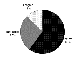 Q1. Implementing a public education program on
intensification represents the right direction for the City.
Q1. Implementing a public education program on
intensification represents the right direction for the City.
Percent Count Choice
60% 153 agree
27% 69 part_agree
13% 32 disagree
Comments often expressed a sentiment that people fear what they do not fully understand. Several responses noted that people need to learn the advantages of living in a more dense community, since many North Americans have not experienced life in more compact, denser self-sustained urban places. It was pointed out that after fifty years of a suburban development pattern, many are quite accustomed to living in less-intensified environments. As a result, they may be unlikely to shift perspectives and ways of living without exposure to these ideas. There was strong support for involving people in more education, more explanation of the concept of intensification, its benefits (comprehensive), visually illustrating examples of good intensification and responding to bad examples in order to eliminate the uncertainties, fears, and falsehoods that are often associated with any major public policy initiative. It was considered that an informed public’s disagreement is more likely to be based on a well-reasoned position that offers a constructive, viable alternative for the City's consideration. There was a degree of cynicism that education could just become ‘propaganda’. It was stressed that education had to be open and transparent about the pros and cons of intensification, address the issues that are important to people, not be an attempt to ‘sell’ an agenda or be presented as ‘Big Brother’ chastising people.
It is apparent from comments on this recommended action that there is still a desire to gain an improved understanding of what intensification is and what its implementation can mean. Several responses concluded that a broad education/information program is the only way to develop a shared understanding of what intensification means.
Several made the point that education should involve success stories from other cities (Canadian or foreign) as examples of the benefits. It was suggested that the City could seek partnerships with schools, universities and colleges in order to educate and inform people on the importance of civic design, public engagement, and sustainable cities. Others noted that the City could engage specialists in the topic to explain the ideas or provide books that teach citizens the notions of civic design and good urbanism. (It is noted that staff are proceeding along some of these lines now – e.g. the Intensification Forum; the preparation of an intensification video to be used as an educational tool).
A substantial number of replies did not want to see a lot of taxpayers’ money spent on a public education program, indicating that few among the general public would respond or be interested, until intensification happens close to them. Others stated that money would be better spent on ensuring good planning is carried out, while others felt the City would be using public funds to try and sell them on an idea they don’t want. There was a recurring sentiment that the best way of educating is through the well-designed examples of intensification that were delivered in accordance with existing zoning and community design plans, but that there are plenty of examples where out-of-scale intensification would counteract positive educational efforts.
.
Q2. Creating a centralized position with the mandate and authority to
coordinate and facilitate the achievement of the city's design objectives
represents the right direction for the city.
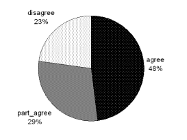
Percent Count Choice
48% 123 agree
29% 75 part agree
23% 58 disagree
Responses to this recommended action (as well as to action # 4 dealing with a design review panel) indicate a high degree of interest in design matters among respondents. Many expressed dissatisfaction with the quality of design of buildings in the city and indicated that the City administration should be organized to oversee and review quality and integrity in Ottawa architecture; advocate for the clear understanding of what is needed at an urban design level, provide a vision for the City and ensure that City officials and developers understand the context and work together. Several responses indicated surprise that the City did not presently have such a position dealing with urban design. Examples were cited from other cities in Canada and internationally where this is a priority.
There were a lot of ideas offered concerning the type of person that may be employed - for example: respected by but not tied to the local development community; a person of vision; experienced in intensification; a local accredited architect; globally aware; someone who will not impair the creative freedom of architects…
However, there is less enthusiasm in funding any new staff positions to carry out a design or architectural mandate. Nevertheless, there was support for a centralized role within the municipal structure that would focus on creating a design culture within the administration and ensuring a high quality of urban design for the city. Some indicated that at present, it appears as though there is no clear and accountable lead for smart growth and intensification; that currently responsibility is spread out amongst too many groups to get any kind of cohesiveness or consensus and that there is no spokesperson for design.
There were numerous suggestions as to how this should be accomplished – from the appointment of a single entity answerable only to the CEO and Council operating with a very small multi-disciplinary staff of highly qualified design professionals; to a Chief supported by an on-going public advisory committee; to the wholesale upgrades of the abilities of the permits approvals staff and processes (including local GIS mapping, 3D models of urban districts, and the ability to perform operations and embodied energy analysis on municipally and privately owned buildings).
Part of the
discussion associated with this action referred to a ‘Chief Architect’. Some commented that an architect may be too
limited; that what was needed was an urban designer. A common theme regarding the role of such a person included the
desire for a community-oriented ‘big picture’ thinker; not a meddler in design
issues, a custodian
of design objectives, not the designer per
se. Those who supported the position
of a Chief Architect emphasized the critical difference between planning and
architecture and that the contribution of architecture has been undervalued in
the city. This group of respondents
considered a trained
architect with professional accreditation should be mandatory for a person who
is responsible for overseeing and reviewing the quality and integrity in Ottawa
architecture. Because we are a capital city, this group felt such a position to
be very important.
There was also a feeling that if a position were to be created, the role must be broad and have authority to get past the barriers and planning silos that presently exist and prevent the City from moving forward in a truly integrated and sustainable planning fashion. At the same time, people are concerned that the role not be powerful without accountability. Recurring themes were of authority, independence, accountability, political will, credibility and objectivity in order to effect real change. Some replies suggested that the person in such a position could change every few years in order to inject fresh ideas and perspectives. There were several responses that indicated that in addition to, or rather than, a single entity there should be a team of persons from varied backgrounds to provide diverse professional input: e.g. architecture, civil engineering, landscape design, urban planning, interior design, urban designers, urban geographers, artists, and community partnerships etc. This idea blends somewhat into the Roundtables’ recommended action #4, the design review panel.
A number of responses urged caution in spending to establish such a position and many suggested that they hoped the objectives could be met through reorganization of existing resources, rather than new hires. Many who objected to this action considered that it would simply result in more bureaucracy, costs would be exorbitant, the process of design review would be subjective, that existing planning staff should be able to do the job, or that it represents too much power in one individual
The bottom line for the majority of respondents appeared to be that if the City is serious in addressing what is seen as a pressing need, it must take steps to show leadership and organize its resources accordingly in a way that will send a message of its commitment to achieving excellence in architecture and urban design.
Q3. Establishing
the political leadership needed to champion the city's design objectives
represents the right direction for the city.
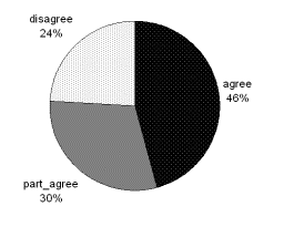
Percent Count Choice
46% 116 agree
30% 76 part_agree
24% 61 disagree
People generally agree that there is a lack of practical leadership at the City in the area of championing urban design. Further, many concluded that if Council does not understand and champion the cause, progress is unlikely. It was considered that without specific ownership of this policy, intensification (and design) runs the risk of being a piecemeal case-by-case, uncoordinated initiative. A recurring theme defining what political leadership might look like was that a clear commitment on Council to a city-wide perspective and vision was needed, rather than the current approach which was deemed to be characteristically short-term, micromanagement, individualistic, ward-centric and protectionist.
Insofar as to ‘who’ might be the person to champion design, some responses indicated the position of Chair of PEC; others, the Mayor, or both. Some respondents preferred that this be a staff position as opposed to an elected position mainly because of the issue of consistency and long-term commitment to the matter. Others pointed out that it must be a joint responsibility shared by staff and all of Council; caution was expressed, however, that as individuals, politicians may change every four years, so a degree of continuity and balance was necessary. Respondents did not always make a distinction between the role of championing the cause of good urban design and qualification to judge and decide what constitutes good design. This may have caused some to react negatively to the notion of a ‘political’ champion, pointing out that elected representatives may not have the technical credentials in urban design or architecture. Many felt that Councillors are subject to too many inherent conflicts of interest to effectively perform this function. Some considered that ‘politicizing’ the role would undermine the need for clear, meaningful, and measurable design objectives and urban design quality standards. Rather, this group felt that political efforts would be appropriately spent in oversight, insisting that intensification projects comply with the existing planning framework.
Within this recommended action, as with some of the other eight Roundtable’s recommendations, the notion of greater linkages with the NCC/federal government was raised, given Ottawa’s status as the capital and given the NCC’s established role in design.
Q4. Establish a formal design review board or panel to facilitate
on-going, effective implementation of quality design in intensification.
Percent Count Choice
45% 113 agree
36% 91 part_agree
19% 48 disagree
This action produced a high proportion of
“Partly Agree” responses, wherein a number of suggestions were made as to
structure, composition and function of a design review panel.
Sentiment was expressed that such a review panel needed to be politically autonomous and unbiased (i.e. no connections with existing development, lobby or advisory interests). Avoiding partisanship/vested interests was also a key concern (e.g. ensuring all applications are “blind” so that no one knows who the proponent is), as was the requirement that the panel be granted authority in its decision-making. The need for the panel to be accountable in its decisions, sensitive to community needs (e.g. possibly through including members of the public on the panel and/or actively seeking community input), and transparent in its process was noted. As well, many felt that the panel would only need to come together as required, to consider major or contentious applications and would not constitute a full-time job. Respondents identified a link between this recommended action and the earlier ones dealing with a ‘Chief Architect’ or similar staff position and political leadership on design. Some viewed all three actions as viable considerations, while some felt the panel, with staff administrative assistance would be adequate. Concerns about overlap, conflicting interests and cost were expressed. There was some support for the inclusion of members of the public on the panel.
A number of respondents felt it would be a
good idea to rotate panel members and to include a variety of professionals
(i.e. not solely architects) some of whom should be from other jurisdictions
outside of Ottawa, so that ideas and perspectives remain fresh. This perspective was balanced by those who
pointed out that panel members (or at least a majority of members) should live
in the city so that they are familiar with community values.
A common thread running throughout most
responses to all of the Roundtable’s recommendations was ‘fiscal
responsibility’ – the panel should be cost neutral (note: nothing was
inferred in this action that the panel would include paid positions) and many
of the comments pointed out that the panel could be composed of qualified
volunteers; avoiding additional administrative layers that would slow down the
process; and using existing resources through reorganization.
The most frequent reasons given for objection was that it would be the cause of further slow- down in an approval process that was already considered to be too lengthy, and costly.
Q5. Create a roundtable of various local stakeholders to facilitate
exchange of information and expertise.
Percent Count Choice
57% 142 agree
31% 77 part_agree
13% 32 disagree
Opinions expressed concern over whether such
a roundtable might end up being taken over by NIMBY sentiments. Overall, however, the general feeling was
that a forum for getting conflict and opinions out of the way in order to
facilitate concentration on common benefits made sense and would be a positive
thing. Some even felt it was crucial to
the success of intensification. As a
vehicle for discussing intensification and associated issues in general,
stakeholder roundtables were seen by some as a way to pre-empt some of the
intense negative reaction that often accompanies individual applications. At the same time, some stated that in the
absence of specific ‘real’ questions to address, roundtables could lead to
unproductive “gabfests”. Many respondents
voiced mistrust over the motivations of and the relationships among the various
stakeholder groups – perceptions that developers always win; that the City and
developers work together; that local community groups are ignored; that elected
representatives are too biased one way or the other – ironically, some who
expressed such opinions said little about what role a roundtable forum might
play to help alleviate such perceptions.
In the end, there was no fruitful conclusion
as to the value of the recommended action: namely, the principle of formally
bringing stakeholder groups that are often on opposing sides on the
intensification debate together in order to facilitate understanding of one
another’s constraints and wishes and create a more positive environment for
future dialogue and negotiation when specific proposals arise. There seemed to be an underlying concern
that a roundtable would be an on-going thing that would waste peoples’ limited
time resources – no one suggested that perhaps a bi-annual session where
stakeholders stepped out of their comfort zone to spend an evening in someone
else’s shoes might have the potential for increasing understanding for
another’s perspectives and building bridges, rather than burning them.
There would seem to be some concern about
how the general public (silent majority) who are not part of an established
community group get a voice at the table.
It is noted that what the June Roundtable members were attempting to
address was how to increase understanding and communication among established
stakeholder groups who routinely ‘butt heads’.
There appears to be a constituency that
feels that more talk will not help and that fundamental flaws in the planning
process associated with intensification need to be addressed first. There was a fair amount of reference to
‘mistrust’, but the majority of input recorded in this regard seemed oriented
to how a particular stakeholder’s group could redress what was perceived to be
an imbalance in the way their particular opinions were treated. The presence of some deeply-held
convictions that the planning process is stacked against certain stakeholder
groups is significant. It is also
significant that there does not seem to have been any real appetite for
bringing these concerns to a roundtable format of all stakeholders. Rather, along with the concern is a demand
that the process change. Some comments
went so far as to recommend disenfranchisement of certain stakeholder groups;
the antithesis of the recommended action.
 Q6. The creation of a city-sponsored and initiated
mediation process for those intensification proposals that are appealed to the
Ontario Municipal Board represents the right direction for the city.
Q6. The creation of a city-sponsored and initiated
mediation process for those intensification proposals that are appealed to the
Ontario Municipal Board represents the right direction for the city.
Percent Count Choice
52% 131 agree
29% 73 part_agree
18% 46 disagree
Concern was expressed that this could be
redundant, since an OMB hearing may be required despite any City-sponsored
mediation. It was also noted that the
OMB itself provides for mediation and that more use of this venue would be an
option to consider. Some see this as a
good idea because it may avoid the necessity of a Hearing altogether and be
less costly for all involved.
A significant number of people expressed the
opinion that mediation be led at arms length from municipal staff, as they
cannot be considered to be neutral and the mediation must be fair and neutral –
e.g. perhaps using an external institution’s mediators funded by the City. These respondents considered that the City
should be the conduit and the organizer (i.e. take care of the logistics), but
City officials should not be perceived as "leading" the mediation but
facilitating it. Those supporting this
particular action expressed that it has the potential to level the playing
field for the public at large, who do not have the resources to attend lengthy
Board hearings; save time and money; and be less confrontational than an OMB
hearing. Some respondents preferred
that issues be resolved between the parties directly affected by the project
and not by a group of individuals who don't have a personal stake in the
community, namely the OMB. There was a distinct dislike expressed for the
Ontario Municipal Board as many individuals considered that, not only was it
disconnected from local values, but decisions were regarded as routinely
favouring development proponents over communities. A number of respondents expressed the hope that such a procedure
could be based on goodwill where the parties were committed to resolving
conflict, rather than winning entrenched positions.
Among those stating opposition to this
action, many cited duplication and, rather than reducing costs to the taxpayer,
it could actually increase them, since a City-led mediation process could
simply be misused as a means of stalling ‘due process’. This type of response considered that anyone
using a City-sponsored process likely was prepared to appeal to the OMB in any
event.
Q7. A developer voluntarily seeking early consultation with a community
prior to the submission of an intensification proposal with a view to gaining
an early understanding of, and wherever possible responding to, local issues in
the development proposal represents the right direction for the city.
Percent Count Choice
70% 174 agree
20% 49 part_agree
11% 27 disagree
Some respondents noted that they would only
support ‘mandatory’ early consultation, as opposed to ‘voluntary’ consultation
and that they do not consider the recommended action will work if it remains
voluntary, at the discretion of the development proponent. It is noted that the Planning Act only gives a municipality the authority to require a
proponent to pre-consult with the City; not with the community. Nevertheless,
it may be possible for a jurisdiction itself to include community
representatives in early consultation meetings between a proponent and the
municipality, thereby initiating earlier contact. Numbers of respondents indicated support for rewarding developers
who voluntarily engaged in early consultation through means such as lower
development fees or a streamlined approvals process.
There
was some qualified agreement for this recommended action: provided such early
consultation was restricted to applications requiring variances and/or “major”
projects; provided it was acknowledged that an element demanding “no change” or
“NIMBY” would likely be present; and provided the community acknowledged that
initial drawings/proposals were just that – preliminary - and that all details
will not have been worked out at this stage.
It was stated that developers may be hesitant about revealing their
intentions before they are fully-formed, funded, responsive to market
characteristics, etc. and may fear the entrenchment of negative
viewpoints. Others were flatly opposed
to the idea. It was pointed out that
there are practical challenges to be faced when dealing with a community,
because there is no single entity that can legitimately claim to speak for the
entire community. The result in
practice can be that while extensive time is invested with a neighbourhood
association and agreement is reached, “splinter” groups can come out after the
fact and appeal a proposal, or convince the elected representative to change
their position. At the same time, some
people provided examples of situations where what had been agreed to was
subsequently changed without notice by the time approval was given by the City. There was a desire to incorporate some
measure of certainty that what had been expressed following consultation would
actually be followed through. It was
noted that there needs to be a record that clearly indicates with whom and when
community pre-consultation took place and require a factual summary of the
consultation feedback.
Several respondents identified that cost and
time savings should result through early identification of issues before plans
have been finalized on the one hand and an early understanding of constraints
to change, as well as what opportunities might be available to modify plans on
the other.
There was a general feeling among the
majority of responses that it is in the long-term interests of all stakeholders
to build trust among the parties and that early consultation would be an
important step in building lasting rapport between the industry and the local
community. It was pointed out that if
community consultation occurs after municipal staff and a developer have
consulted, the developer may have already invested time and money in studies
and multiple copies of drawings to meet the initial requirements of the City,
only to be faced with a community who then asks them to start over.
It was generally conceded that the “earlier
consultation occurs, the better”, to the point of prior to an application being
submitted to the City.
There was some suggestion that it would be
valuable to publicize the costs of not doing adequate consultation (presumably
the delays, debate and OMB hearings) – i.e. demonstrating the benefits of early
pre-consultation and of publicly highlighting where positive relationships have
evolved through the work of stakeholder groups.
While it is not possible to generalize,
consultation does not guarantee consensus.
At the same time, it was indicated that development proponents will only
benefit from pre-consultation if they are prepared to listen and modify their
proposals where possible (which speaks to doing it early on before a proposal
is for all intents and purposes ‘final’). If a proponent regards
pre-consultation only as a ‘presentation’ of a proposal, he or she may be
setting themselves up for disappointment if when showing it to residents, they
“don’t like it”. It was acknowledged by
one response that early pre-consultation requires a flexibility of mind and
willingness to listen on both sides and that this flexibility can only be
developed through practice by both developers and community groups.
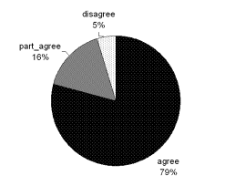 Q8. Recognizing that intensification needs a parallel
and coordinated effort in the provision of community infrastructure and
amenities to accommodate growth represents the right direction for the city.
Q8. Recognizing that intensification needs a parallel
and coordinated effort in the provision of community infrastructure and
amenities to accommodate growth represents the right direction for the city.
Percent Count Choice
79% 196 agree
16% 40 part_agree
5% 12 disagree
Note: Most comments indicated that this recommended action was just common sense; some pointed out that this was a major concern with intensification which, if addressed, would reduce the incidence of opposition to intensification - hence the high ratio of agreement or partial agreement and the very low incidence of disagreement. Several people commented that the coordination of services and infrastructure isn’t all that different an issue for greenfields development where, it was pointed out, service provision often lags behind new subdivision development. The preponderance of opinion was that infrastructure needs to be provided first, in anticipation of intensification, or at least parallel with development.
Some comments identified the need for ‘soft’ services, such as parks, daycares, public art, libraries, etc. Issues of cost were noted, including consideration that infrastructure upgrades be paid for by development.
It is noted that the Infrastructure Capacity Strategy seeks to proactively direct sewer upgrades within intensification target areas throughout the city. The Strategy acknowledges the coordination of capacity with areas identified for growth. There is also a recognition that Development Charges need to be updated to recognize that infrastructure upgrades contain a significant growth component in addition to the need for upgrades to ensure continuing service as existing pipes age.
A number of people responded to the idea of requiring development to enhance community benefits in exchange for increases in density/height (S.37 of the Planning Act). Support for this outweighed disagreement. This is being explored parallel to the Official Plan Review and will be the subject of a separate report to Council. Related to this, a number of comments stated that good design should not be a bargaining tool; it should be expected as part of every development, not an element that is negotiated for increases in height or density.
Q9. Ensuring that
municipal policies support intensification and good urban design 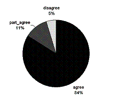 represents the right direction for the city.
Percent Count Choice
84% 207 agree
11% 28 part_agree
5% 12 disagree
Note: Several
responses were of the conviction that getting the municipal policy and
regulatory environment pulling in the same direction was fundamental and that
if intensification
isn't done right (i.e. result in more liveable communities with good services,
shopping and cultural activities and which are cyclist and pedestrian-friendly)
it will drive people out of the city and into surrounding towns, villages and
communities, creating greater urban sprawl.
People stressed that there must be a proper balance between quality of
life and design for housing and services.
Many respondents focused on providing examples of the kind of things they considered to be important in achieving good intensification – e.g. traffic reduction/more walkable; preserving and planting more trees; parking strategies; integrated, mixed-use development; revisions to the tax structure to make it more attractive to live in intensified areas; more cycling facilities and increased levels of transit service; better urban design; parks and open spaces
The automobile featured prominently in responses to this action item – i.e. the need to reduce auto-dependence; designing smaller more intense pedestrian-oriented services such as retail oriented to the sidewalk or pedestrian spaces; promoting on-street parking/use of alternative means of access to automobiles (shared use).
There was also a sentiment that while the City’s policy base is sound, implementation and follow-through are often not consistent with the policy direction, which is really what the Roundtable’s recommended action was meant to point out: that the municipality’s regulatory framework, budget, standards and practices should be coordinated to support delivery of more compact communities.
The top three actions were as follows:
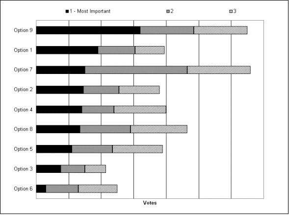 Action 7– ‘Early Consultation with
Community by Development Proponent’ was ranked ‘1’ third most often. It is noted that this action was ranked
‘1’ and ‘2’ more often than Action 1.
Action 7– ‘Early Consultation with
Community by Development Proponent’ was ranked ‘1’ third most often. It is noted that this action was ranked
‘1’ and ‘2’ more often than Action 1.
DOCUMENT 7c
Responses were
many and varied. An attempt has been
made to categorize the input directly under broad headings. The following is the verbatim input provided
by respondents:
Budget / Tax-related
Identify the core resources. My two cents on
core resources (in no particular order): police, fire, paramedics, water
quality, transit, public housing. All the other things are NICE TO HAVE (for
example, museums, sports fields / buildings, libraries, galleries, concert
halls, festivals). Every group that comes begging for $$$, should not get it.
If it's that important a service, they should be able to raise $$$ on their
own.
Logical property taxes. Make property taxes proportional to the
distance of homes from the city core. Or three-tiered taxation system. Lowest
for homes in the city core, medium for people who have been living in the suburbs
for say more than 5 years and highest for people who have contributed to urban
sprawl say in the last 5 years. It is because of suburbanites that we have to
pay higher taxes to transport water and sewage and to widen roads. This would
be a simple way of greatly encouraging intensification.
Saving tax payer money by cutting back
useless red tape and pet projects.
Ensure development fees fully recover the
cost of development whether intensification or building the slums of tomorrow
i.e. greenfield executive subdivisions.
Try to run the s city on a budget. It's
wonderful to have plans, but with taxes that always go up, what are the seniors
and working families to do?
Possible tax incentives for existing
business to clean up building facades, etc would also be helpful in the long
run for improving the liveability of intensified areas.
These are big ideas. Ensure to make the plan
reasonable so it is not too costly and not too difficult to put in place or so
it won't be able to be completed till years down the road when much of the city
has already been "intensified".
Design-related
Requirements for design competition for
projects receiving City funds (directly or indirectly) or for major projects
(i.e. above a specified value).
I think that you should provide tax cuts for
the use of design competitions to ensure that new developments are attractive.
New urbanism.
Design
Guidelines and Standards. Include for articulation of facades, sensitive
materials and a design that considers the city street with drawings that
include at minimum one block of adjacent buildings.
Design Award program.
Incentivize good design.
The leadership on design positions require
expertise and teeth. The city needs to compare itself to other capitals in a
very objective way and truly understand that the city has to embrace design,
and not just leave it up to the NCC and the Parliamentary Precinct.
The most important thing is excellence in
Architecture and Urban Design, and excellence is measured by global standards,
not just local standards. The City must build their respect for design
professional who have long backgrounds in design and global experience in
Architecture and Design.
Lead by example: put design/innovation as
the top requirement for City projects; insist on design charettes and
integrated design for all its projects; insist on certified sustainable
development (note: intensification is green); divert a healthy portion of its
marketing/tourism budget on design competitions.
Consult Don Schmidt on Process + also consider
Design Review Panel to include architects and planners from different cities
across Canada. Halifax, Montreal, Toronto, Winnipeg, Vancouver etc where urban
infill projects are a known entity!!!
Substitute an 'Urban Designer In Residence'
position for a 3 year term at 1$ per year, rather that a political position.
Hold more design competitions - competition
enhances creativity and breaks away from the status quo.
Education/Relationship with Community
I would suggest not imparting entire policy
documents but well written abridged versions that maintain the vital
information while removing the unnecessary excess - community involvement is
from participants who do this in their free time, not as part of their already
full work days so an impartial person to produce useful abridged versions of
these that are sufficiently informative would be really appreciated.
Raise awareness of the general public about
the vision for the growth of Ottawa, and obtain a buy-in by the citizens. It
will be a lot easier achieving success on such issues as transportation when
citizens can see where the plan fits in the larger picture.
Consider being more open with the public.
The city's efforts, so far, have often resulted in 'ghettoization and the
destruction of communities.
The city has made great steps to become more
informative and engage the residents of Ottawa; I would just encourage them to
keep it up !
Pay more attention to the needs and wants of
the inhabitants of the city and less to the aspirations of the Mayor and the
Councillors. It is the people who bear the brunt of the problems; the
"Leaders" go on to bigger things and never have to bear the
responsibility for their actions while in office!
Look seriously at behaviour of current
planning staff and their disrespect for community, who after all they are meant
to serve.
Since the bylaws reflect the city plan, it
should be a major concern when developers or owners want variances, especially
if the community raises a major concern. If the community is concerned, the
city government has a responsibility to help them addresses these concerns. A
knowledgeable ombudsman or mediation committee that would work with the
developer or owner and the community could improve on the acceptance of
intensification. Ottawa has done an exceptional job of keeping the downtown
core very alive and there should be responsible growth. A hearing for a minor
variance where only the decision is provided with no explanation does not
provide a very satisfying result, especially since the community is usually not
successful with their concerns. It appears that the decisions are made on the
information that the developer provides and increasing the tax base for the
city.
More advanced notice of public consultations
(on the city website and in the papers) would be helpful. Many times the word
goes out too late.
Sell intensification better.
Move from a big government/big business
approach to a local consultative approach.
Education and participation is crucial for success. It can't be
"don't worry, we know what's best" attitude.
Consider avoiding more costly, bureaucratic
and time-consuming "Big Government" solutions, and let the
communities and the private interests determine their own future, with or
without intensification, as they see fit.
Provide success stories as part of the
education component.
Long-term initiatives to foster and support
informed community groups outside of city structures.
Support for community associations to
articulate their vision of their communities and Ottawa as a whole. Support
Community involvement in the forming of the Official City Plan. The resources
available to communities are not equal to those of the developers. The City
needs to help equalize that issue. The position of a Chief Architect or equivalent
could help to address this issue.
Take a
tour of cities that work; perhaps a virtual tour through research. Sponsor a
contest across Canadian university urban planning/architecture departments to
design a vision for Ottawa 2020. Publicize these results broadly, and invite
public discourse. This brings the next generation of urban dwellers and
hopefully Ottawa residents into the discussion. Publicize the results,
incorporate some of them into a long-term strategic design plan. Follow the
plan. Aim to be the top liveable city in North America. Then aim higher.
Ensure that the Community Design Plans which
have been developed through extensive community participation e.g. the one for
Old Ottawa East, are accepted by City Staff, and that City staff are not
allowed to impose their vision on what a community has decided is best for it.
There needs to be a process for community
associations, which attempt to accurately represent the collective view of
neighbourhoods, to provide more formalized feedback on an ongoing basis.
I would strongly recommend profiling or
initiating pilot projects and to promote these (note: assume “these”
refer to the nine recommended actions).
Start to monitor high-rise living concerns
and develop an advocate for those who live in an intensified environment. Those
who reduce their environmental footprint by moving into a high-rise condo
should not become second-class citizens in regards to privacy and light
(through lack of interest/understanding at city hall).
Define what intensification is ... establish
- with communities - targets for intensification.
Make policies, rationale and decisions more
public. Have them readily available within the communities as well as through
the City of Ottawa site. Any major develop project should have a sign on it
where the citizens can get more information on what is happening at that
location and why. I find we are left in the dark on develop plans (especially
private properties) and the only thing we see is a sign for requests for input
variance requests. We never get the final decisions.
This needs to also start with a strong
public awareness program i.e., what is it, what it isn't, long-term benefits
for the city, how consultation will take place, etc.
Environment-related
Give environmental costs a high weight when
considering intensification proposals.
Need to assess impact on the air, water and
land environment as a result of intensification i.e. greater population (and
vehicle) densities in one part of the city could result in poorer air quality
if taken to extremes unless counter measures taken (to route vehicles away from
residential areas)
The City needs to attach a real value to its
tree cover and urban forests. In the old City and in other City's in Canada
trees are valued (using a monetary figure based on an accepted formula) and
when developments are proposed, the developer has a financial incentive to
maintain those trees.
Protect urban green space at all costs.
Clean up and develop brown fields.
As a
former employee of the Canada Green Building Council I was often asked what, if
any, incentives were available to builders of green projects. Sadly I had to
say there were none, the City of Ottawa must step up to the plate and ensure
the "greening" of future projects is
front
and centre of any intensification program. Also incentives do not have to be
monetary, they can be as simple as short-term (say 5 or 10 years) reduced
development fees, reduced taxes, expedited approval processes or assistance
with accessing any provincial or
federal
incentives.
Incorporating green roofs for municipal
infrastructure intensification (minimum) or making it a standard for all
intensification projects.
I also suggest that City Council strongly
consider adding requirements for rooftop green spaces on all new condo/office
tower constructions and require developers to use solar technology to power
hallway or other common element lighting, heating, etc, where possible.
Adhere to the zoning and do not arbitrarily
agree to spot zoning to permit intensification; ensure that proposals for
intensification retain the trees that are present and do not permit their
removal or destruction by grade changes on a lot; large format retail is
destructive of the environment - do something to restrict and reduce parking
lots that are huge and fully paved - find a way to permit the trees in parking
lots to survive beyond a 2-year life span.
Developing a series of thematic maps to
visualize energy intensity, GHG and costs associated with energy end use across
the city. These maps should be developed for today, as well as based on
projections of zoning and intensification projections. This would help city
councillors and the public visualize the energy implications of existing urban
patterns and growth projections. In absence of this information, decisions will
continue to be made on a piecemeal basis, without an understanding of their
overall energy/cost/greenhouse gas implications. Of course a functioning
community energy plan that's linked to other plans and development decisions
would help to implement this.
Ensure approval of all development proposals
considers environmental sustainability. Increase the prominence of
sustainability within the city - it is time for the official plans policies to
be implemented on a day to day basis.
Ensure that Hydro Ottawa removes their
current barriers to renewable energy generation (i.e. grid connected renewable
electricity generation).
Engage expertise of local green building
community and experience with integrated and sustainable design process.
Geographically-based
Encourage
development of brownfields in industrial areas inside the greenbelt.
In your public education, please include the
benefits for preservation of the rural areas.
Freeze the urban development boundary.
Establish higher intensification objectives for suburban parts of the city (ex.
Kanata, Orléans) and increase development charges for projects.
Move the football stadium to Lebreton Flats.
Use the existing facilities for soccer only and turn Lansdowne into a park with
trees, lakes, etc. Get rid of the asphalt.
The City and province should look to create
a region-wide Greenbelt - look at all the intensification happening in Toronto
since the Greenbelt and Places to Grow!
Promote residential intensification, instead
of more big box stores (like Trainyards complex). If possible, rezone the
remainder of the unbuilt Trainyards complex (Trainyards II etc) to residential.
The City really blew it when it allowed Trainyards I to go forward -- the site
would have been excellent place for intensification. Also, make sure that new
developments (e.g. Riverside South) have appropriate densification to allow
people to live and work in the same community – it is not too late!
Overall master plan for the whole City.
The
wrong place for intensification is the already most dense neighbourhoods like
the Market and Centretown, even Glebe and Old Ottawa East/South. The best place
for intensification is the old suburbs with large lots that can easily support
multiple dwellings, such as Alta Vista and west of Island Park.
Governance-related
There is no leadership at City Hall. The
councillors should be educated on how to look at the whole city and not just
their region. The city itself and the councillors should not get into bed with
the developers.
Work to eliminate the role of the OMB in
Ottawa. Work to eliminate the NCC.
Ensure that Councillors' interactions with
developers and the real estate business are transparent. Ban those with
connections to the industries from holding municipal office.
The roundtable panel seems to be focussed on
project specific developments without a recommendation for a region wide
conceptual land use map for 2050. We also need integrated community design
plans/secondary policy plans which lead logically from the conceptual map to
the actual development proposal. Building a house or addition to a house
without an architectural framework showing the future ducting, wiring, traffic
flow, plumbing etc. would not make sense, yet this is precisely what we seem to
be doing when we propose a project within the City of Ottawa boundaries. In
discussing his new book, John Ralston Saul even questions the rationale and
locations for some of the projects being built across this City. We have to
think and plan for the distant future! I believe the roundtable panel therefore
missed the need for a region-wide Governance structure for holistic
urban-rural, region-wide planning, as well as the need for Community Design
Plans that have community involvement and input.
De-Amalgamate
immediately (Note: two separate inputs).
Have a
committee study how other cities are handling the issue, and sort out what
those cities think is working. No point in reinventing the wheel.
Banning political campaign donations and
other contributions from developers; opening city councillor and staff meetings
with developers to observers such as advisory panels; fighting bad development
at the OMB and beyond (judicial reviews) seriously, instead of backing
developers in bad projects and turning its back -or turning against- the
residents it supposedly represents.
Meet with representatives from other
high-density cities in Canada and possibly the US determining what has worked
and not worked as they have "grown into their master plans".
The idea of intensification is not something
that has originated in the City of Ottawa. There are many existing examples
worldwide and in Canada to follow as models. Some of these non-sprawling
intensified cities have been carefully planned as such, and some have developed
naturally that way. Though none are likely to be perfect matches for the design
and development needs of Ottawa, and problems can no doubt be identified in any
of these cities, I suggest identifying a number of best examples to use as
models for various aspects of the intensification planning process.
Any design leadership should be done in full
concert with the federal government (NCC, PWGSC) as they are also responsible
for some of Ottawa's mistakes.
I think that more should be done to persuade
the federal government to respect the city's design and intensification
efforts.
There must be a stop to councillors
receiving money from developers and corporations. The election law for
municipalities must be changed to not allow candidates and sitting councillors
to receive money from anyone but private individuals and that these
contributions be capped at a set limit.
Where heritage matters are involved in
intensification issues, opinions from LACAC should count for more than PEC -
LACAC members are trained to do what they do; PEC members do not appear to have
any special training in this field.
City Councillors should look at examples
like Chicago where Architectural Committees deal with design issues and
Councillors deal with political issues. Unfortunately our present Council dos
not know how to appoint qualified people, delegate authority and move on.
Process / Administrative-related
Ensure political independence of the
(design) panel and the process once initiated.
To actually do this and to be transparent
with the whole process.
Revamp the planning approvals approach in
the planning department to be more community-centred, with community planners
acting as "captains" or "prime contacts" to manage and
participate in all aspects of development applications and related
consultations within the
City and the community. Community planners
should become familiar with their communities and be involved in policy-setting
initiatives as well as development applications. Also, break down the silos
currently separating those who draft Official Plans, Community Plans and Zoning
By-laws from those who implement them.
Enforce
the by laws and meet the Official Plan provisions.
Do not allow intensification to occur
piecemeal. If it is worth doing, it should be done according to a set plan,
consistently, and after analysis of impacts on and in consultation with the
targeted neighbourhoods.
City hall should streamline planning process
(1 planner assigned for the entire file he or she is handling (includes OMB, Committee
of Adjustment, PEC, etc).
Enforce existing by-laws and policies.
1. For the mediation process ensure that
local tax payers have a very strong say, through voting, and that the city is
prepared to support local tax payer before giving in to any externally imposed
boards. 2. All business cases to be fully documented before and after project
implementation so that lessons can be learned, tax payers not left
"holding the bag", etc. With compensation to tax payers should
"the goods not be delivered". 3. As with the above, there should be a
procedure for lessons learned, tracking delivery of product against promised,
etc.
Whatever
actions are finally implemented, set up a on-going review process to measure
the effectiveness of the measures. A performance measurement framework needs to
be defined that monitors progress, one appropriate to the measure, and that is
meaningful - not motherhood statements like "is the city more
beautiful?"
Making their own processes easier to
follow/use ....many people get frustrated with how convoluted the City
processes are ----streamline it & ensure that all groups with in the city
can easily share information.
Speed up processes.
Charette process.
Shortening the approval process and giving
developers more freedom within certain guidelines.
Assess
all legal, regulatory and other tools in existence from the standpoint of gaps
and barriers to implement OP policies relating to improving the quality of life
in the City and then address the gaps with meaningful legal and regulatory
tools that have teeth to affect change. Otherwise, all else is window dressing.
Get the Planning Department re-structured to
deal with these issues as outlined in the Municipal
Act, Planning Act, etc.
Consider saving tax dollars for once and reducing
the city Bureaucracy...don’t add to it. If you are going to create new
positions, how about getting rid of some other ones or reducing the number of
unnecessary managers first?
The city should defend ALL CoA findings at
OMB. It is unfair the expect residents to do the City’s job at their expense.
City departments should communicate better
with one another to promote better design
Cost analysis presented by developer should
consider "all" aspects of potential changes required i.e. sewer
upgrade, sidewalks, traffic and street changes.
Freeze the urban boundary, set minimum
density targets, and increase development charges in the suburbs.
With costs a huge consideration at the city,
other monetary ways to encourage people to live in the city and not move or
shop out in the suburbs could be implemented. These include increased
development fees to build outside the city rather than in. Currently the fees
are too low -- building houses outside the city permanently increase
infrastructure costs, that are not covered either by the current tax system or
by the development costs. Also, parking in malls is currently free -- if it
cost people to park in such lots, then more people would live and shop within
the city, and this would 1) decrease cars on the road and 2) increase revenues
to the city.
Hold back on development away from current
infrastructure until the city can catch up, financially it is not possible to
provide the needed infrastructure for all the "developers plans"
which are often lousy, incentives to build on current supports need to be
developed. Not on new land? And build the transit and provide incentives for
development along the transit corridors. Make it all work seamlessly not in
isolation/silos.
Be
proactive by setting out detailed characterizations of what the City wants to
see. City should move to identify areas that are deserving of special
consideration/process (e.g., old and new Heritage Conservation Districts).
Nothing. All the processes needed to ensure
intensification are already in place. They just need competent staff to
implement them and politicians to actually listen to staff recommendations and
keep their uniformed opinions to themselves.
Moratorium pending adoption of policies.
The intensification criteria should be comprehensive,
clear, and BINDING. Residents have to be given reassurance that the guidelines
will be followed all the time.
The City needs to tackle the fundamental
problem underlying the problems that have been identified: 1) define
intensification the way the Provincial Policy Statement does, as increase in
units, not increase above zoning, and not just by amending the Official Plan,
but in the working definition used in planning approvals by the City. 2)
Amend the zoning bylaw so that it
accommodates normal intensification in the majority of cases, so that people
will already know generally what to expect will happen in their communities and
there will be fewer appeals. 3) Figure out how to implement design guidelines,
instead of simply producing them in increasing numbers. If a given development
proposal requires relief from the bylaw (either Committee of Adjustment or
rezoning), then it should be possible to require that good design be an element
in return for such relief. The same should be true for main streets and mixed
use areas targeted for intensification—design has to be more than simply a
catchphrase that developers and city planners use to justify bigger buildings
of no real actual design merit.
Respect existing zoning bylaws and community
design proposals.
Neighbourhoods transition over 20 to 50 year
time frames. The existing zoning and planning processes already allow
developers the tools to increase density and the delta between existing built
form and permitted zoning allows this transition to occur at a measured pace.
The problem with much of the talk of intensification is that it disrupts
neighbourhoods by accelerating intensification on a spot basis which undermines
a communities sense of it’s self (introducing risk for existing owners, and
changing the character of a neighbourhood at a rate that is faster that people
can accommodate). The other issue is that much of this essentially transfers
the value that accrues to a broad number of people when development is more
uniform (as anticipated in by existing zoning) to the single developer of a
spot site that exceeds the zoning. Neighbours lose twice; their community
suffers if the development is excessive and they lose economically through
reduced opportunities to sell for development and increased risk for buyers
desiring the current built form.
Demographic and behavioural model for
integrated planning and analysis of urban development, incorporating the
interactions between land use, transportation, and public policy. The effects
of some proposed "intensification" are often the opposite of what
simple-minded thinking would predict. This is too important to leave to
opinions, given the possibility to do more harm than good. Return to proving
needs. Refer back to VURLS and other studies to see what housing forms are in
shortest supply, which areas most lack walkable retail (or senior housing,
rooming houses, park space, or whatever else), and what is the global effect of
the project or the community plan on the available land supply, urban boundary,
and total vkt.
1. Improve the planning process so it takes
1-2 months instead of the current 6-9 months; 2. Phase in payment of
development charges (or eliminate them) for intensification if it meets certain
criteria (such as being green design, providing additional housing in certain
areas, providing a certain % of non-profit housing units); allow parkland
levies to be directed to community assistance projects such as funding homeless
shelters or charities that do community work such as habitat for humanity.
Stop 'spot zoning' in the name of
intensification. Re-instate FSI.
Streamline process for projects that are
small and projects that fall within current zoning.
Lobbying provincial planning board to be a
little more interested in City views on intensification. Developers don't
always get it right the first time. Design best practices should be the norm.
Transportation-related
Trains to Stittsville. Trains to Orleans.
Get on with it. You have a train to the south (Barrhaven) already. New Bridge
Barrhaven across the Rideau. New Bridge across the Ottawa River.
Closely relate intensification efforts and
the provision of improved transit access.
Please build more bike paths so that cyclist
commuters can ride safely on streets in the downtown core. Bring the transitway
or LRT closer to main streets so that they more accessible and more welcoming
to women who have to travel at night.
Bike
lanes on ALL new road construction (I don't have a car, but I bike everywhere).
Build
the subway system asap.
Stop spending so much money on new suburban
roads and direct it to new cycling infrastructure and transit to support
intensification. This is more of a TMP issue, but it is crucially related to
intensification and encouraging redevelopment.
A more coordinated non-car centric
transportation plan. "Transportation" should not just be about
widening roads! We need more cycling lanes and transit. I'm sick of sitting in
traffic on the Queensway - please give me options that get me out of my car!
Mandatory high standards of technically
sound building construction detailing and practices, which would be over and
above the minimum standards of the Ontario Building Code. Very few architects
actually know how to properly detail a building to avoid damage in later years.
Combine that with fewer developers interested in spending the money to
implement long lasting building materials into their projects. BC established
similar criteria, so has England- they have been making improvements in their
building codes over the past few years to legislate energy efficient and
durable buildings. If the municipality had put these initiatives into practice
many years ago, we would not be in the situation we are in with million dollar
repair bills on buildings that are falling apart after less than 10 years and a
blight in the City landscape.
As
with all development, adequate space must be maintained for utilities to
install and maintain reliable services to the development area. Utility space
requirements are based on such things as the Building Code, Occupational Health
and Safety Act, the Electrical Code, Electrical Safety Authority Requirements
and Codes issued by the Ontario Energy Board. Hydro Ottawa in particular has
requirements for clearance from overhead pole lines, and pad-mounted equipment
that are for the safety of the construction community, public at large and
utility staff. Intensification development may result in the need to relocate
overhead wire, convert overhead wires to an underground system, or relocate
underground equipment prior to construction beginning, at the developer's
costs. Relocation costs may be prohibitive with respect to the scale of the
development project. Hydro Ottawa welcomes the opportunity to provide
information regarding the practical integration of utility infrastructure into
intensification plans.
Make development fees commensurate with
services provided; e.g. rural greenfield developments should cover the cost of
sewers etc. not only on the site but also between the new development and the core,
including provision for transportation to the core, i.e. roads and transit.
Make sure that building new roads becomes
less of a priority.
Other
More benchmarking. Ottawa is not the only
city to struggle with these issues. How have other's managed it, e.g. Calgary,
Quebec City?
I believe the 9 items above, if done well,
will serve us well as we proceed.
Get money to be able to implement these
steps.
Minimize cost to implement
"program" costs.
Reconsider "intensification" for
what it is: allowing developers to build as high as they want. There need to be
reasonable limits!
I like everything that has been mentioned.
The city should recognize that the city has
developed over 100 years and the will of people to move to the suburbs was a
strong one. To now attempt to centralize everything by intensification will
penalize those who have contributed so much in tax dollars. Doucet wants
everyone to live within 3 miles of his location and walk everywhere. sorry but
the automobile is an integral part of living and a necessity for seniors. We
bought in good faith and now there is an attempt to change the rules.
Get rid of the ridiculous height
restrictions!
We should get rid of "my way - your
way" attitude and recognize that our city will have a variety of living
styles and find the blend that works.
I think that the density standards need to
be re-examined because there is very little difference between the
qualification for low- or medium- density.
Quit making the city a make work project for
all interested people looking for work.
Steamroll the NIMBY-ites. Have people with a
strong vision run things rather than counsellors who strive for mediocrity in
the name of votes.
DO ALL of the above (note: all 9 recommended
actions). They only work as a system and are not mutually exclusive.
Employment agreements with employees
preventing future involvement in the development community for a period after
leaving the city. 2 years. 5 years?
Shorter surveys!
All nine are important but quite a few are
linked and the relationships of some must be made clear and unambiguous (e.g.
2, 3, 4, and maybe 5; then also 1 to 8 and 9.
My overall opinion is that intensification
is a bad policy. It should be dropped by the city.
Triple bottom line sustainability -
economic, social and environmental benefits (not just neutral). Every action
taken should improve in all 3 of these areas. This is addressed in part by a
number of the actions above, but does not seem to appear as a comprehensive
goal.
I disagree with the previously listed 9
items since we in Planning already have the ability to do what is needed. What
is required is the removal of the handicapping that is in place as the
"developer" is now able to influence and sway good planning and do so
without scrutiny by the public. Get the politics and influential developers out
of the process of good planning.
Transparency will allow for better future development.
Show leadership with respect to securing
multi-tenant residential projects....no more condos. People with 200k have lots
of options with respect to finding a home, the lower middle class
and lower class of the city do not. We need
affordable housing, get creative!
DOCUMENT 7d
1. Building Collaboration and Trust
The Question
What do you recommend to the City of Ottawa to enable builders, residents, architects, and the City to collaboratively address intensification issues in a high-trust environment?
The
Environment of Collaboration and Trust We Desire
Productive and trusting relationships exist among the varied threads in the fabric of the Ottawa community. Citizens, architects, planners, developers and municipal government engage in dialogue with one another in community-building processes that benefit everyone. Learning from one another is not only seen as a possibility, but is regarded as essential for intensification to deliver on the promise it holds. Individuals work smoothly across sectors and develop common approaches that encompass business success, neighbourhood goals and regional competitiveness. Groups of “civic entrepreneurs” advise on intensification issues by leaving their “official” hat at home, and come together to better understand and realize the vision of the wider community.
Intensification issues are collaboratively
addressed by harnessing the diversity
that citizens, developers, architects, planners, and municipal government
bring. Previously untapped resources of local knowledge and expertise are
employed to accomplish what individuals working alone could not. Individuals are increasingly motivated by a
desire to make a difference beyond the boundaries of their personal, private or
corporate lives and local preferences and priorities respect the broader
citywide context. The process of
intensification is viewed as “building” the community - making it better, both
from a human perspective and from that of “place”.
A pro-active
approach to intensification is followed whereby all stakeholders are
involved early in development and redevelopment projects and there is a
welcoming space for everyone to contribute their knowledge and ideas. As a
result:
The Issue
Why does the City of Ottawa want to foster
collaboration and trust among stakeholders to meet its intensification goals?
The City of Ottawa believes in the principle
of intensification as a method to achieve several objectives: to preserve
farmland and environmental land; to reduce the environmental footprint of the
city; to curb sprawl and its attendant costs in extensions of roads and
infrastructure; and to cut greenhouse gas emissions by supporting public
transportation over the private automobile.
When it comes to bringing intensification
proposals to existing neighbourhoods, however, intensification has proven to be
a real ‘hot button’ for developers, community groups, the architecture
profession, City Councillors, and municipal staff planners. Discussion of intensification proposals
often devolve into personal and corporate agendas based on narrow
self-interest, and a mechanism is needed to promote shared values, mutual
obligation, trust and responsibility for the community as a whole.
What are
stakeholders telling the City of Ottawa about their present relationships?
Developers take on financial risks in
bringing a new development on stream. In doing so, they have come to expect: a fight; lengthy appeals
to the Ontario Municipal Board; raucous community meetings; and acrimonious
debates at City Council. Developers
also expect to make a profit; otherwise, they would not be doing what they
do. To a developer, time is literally
money and every new project contains an element of risk. Yet for $125, a single individual can tie up
a project for months through an appeal to the Ontario Municipal Board. The expenditure of protracted periods of
time in unproductive debate understandably creates angst among those community
stakeholders who shoulder the most risk for the outcome.
Citizens are the experts in the liveability
of their own neighbourhood. Community groups may be prepared to accept
intensification but intensification that ‘fits’ not overwhelms; they desire new
development that enhances the character of a neighbourhood, not changes it
forever. And, when presented with a
“fait accompli” by a development proponent and asked to react to it, react they
do! Images of high-rise towers,
lacklustre design, diminishing property values, shadows, undesirable
neighbours, congestion and environmental impacts all combine to create a vision
of the future that is almost apocalyptic. Many individuals seem to feel that developers
are routinely out to gouge them through overdevelopment.
Professional architects and designers possess
skills to openly explore innovative solutions that support both the aspiration
of the developer and respect the character of the community. The architectural
profession, like many others, can find it difficult to relate to community
groups and may find it somewhat uncharted territory to, in the words of one
practitioner, “open the ‘black box’ of their profession’s knowledge base to
public scrutiny, and to use their skills to actively engage people in the
design process”. This may be
particularly so when their client, who is paying the bills, wants to maintain
close control over project costs and direction in the face of opposition and
scepticism among a public with a strong emotional attachment to the area that
is the subject of the professional’s interest.
City Councillors must consider budget
implications, constituency growth, unhappy constituents, management of
community expectations, and fulfilment of strategic citywide goals. They often view themselves as ‘the ham in
the sandwich’. Given the size and
complexity of the city it is not surprising to find inner city elected
representatives at odds with their suburban counterparts and rural councillors
opposing urban colleagues on Council on many issues. This kind of situation is not healthy in the long run to
resolving the big city-shaping issues, including that of intensification, which
must be tackled not only in a comprehensive way, but one property at a time
through individual development applications.
2.
Creating a Design Culture
The Question
What do you recommend to the City of Ottawa to cultivate a design culture, both within the municipal organization and in its relationship with its various stakeholder groups, whereby intensification goals will be met by applying the principles of “good design”?
The Design
Culture We Desire
The design culture that exists among Council, planners, architects, developers, and residents ensures the principles of good design are followed and intensification goals are achieved. The parameters of what “good design means” are crystal clear and stakeholders recognize that good design brings social and economic value to the city.
Intensification projects enhance the character of the community in which they are located. Redevelopment and infill projects fit within their neighbourhood context and respond to the interrelationship between good building design and walkable streetscapes. As a community, we expect that new buildings are designed to be appropriate in size, proportion, shape and layout. Such attention to architectural excellence helps to create well-defined streets and spaces, which are attractive and user-friendly and improve residents’ quality of life. Even those buildings and spaces that perform utilitarian functions are modest triumphs of quality and care. The City of Ottawa is beautiful and sustainable.
All stakeholders work together to cooperatively balance the elements of intensification. Expectations about the City’s role and responsibilities are clearly defined and there is a common understanding among Council, all parts of the City’s organization, architects, developers, and residents of each other’s roles and responsibilities with respect to fostering a shared design culture and implementing good urban design.
The City has a strategy for carrying out its design roles, has the resources to implement this strategy, and takes action to implement the strategy. Good design is rewarded and poor design is not approved. The City has a budget for this work, city standards and by-laws are aligned with a context-sensitive design approach, and Council offers leadership and political support for good design in Ottawa.
The Issue
Why does the
City of Ottawa want to foster a culture of good design?
How a neighbourhood looks affects how residents feel about where they live, and good design, character and quality help increase community pride. Creating a sense of place greatly depends on the quality of the buildings and the spaces around them. A high standard of architecture, coupled with a strong landscape strategy combine to set a benchmark for future redevelopment and infill. Attention to aspects such as building height, massing, site development, and street interface are necessary to establish compatibility between existing and new development.
Attention to good design can also help distinguish new development in Ottawa from the same kind of uniform development that characterizes almost all cities in North America. Good design can create distinct neighbourhoods, quality shopping streets and creative employment areas. Together, elements such as buildings and bridges, parks and plazas, and streets, sidewalks and bike paths as well as the way people use them constitute the building blocks of our communities that create lasting impressions. Careful attention to the design of these elements is part of the legacy we leave future generations.
It is generally recognized that intensification projects that work well must also fit well within their physical context. Sometimes, however, the existing physical context has no distinctive character and needs the application of urban design principles to create a sense of local pride and identity. Some developments in recent years have intensified without adequate regard for urban design in the form of compatibility, transitions, buffering, and general contribution to public space and the surrounding streetscape. At the same time, the need for investment in public infrastructure has for too long been a neglected part of the equation. The quality of streetscapes, lighting, trees, street furniture and vegetation all make positive or negative impressions that can affect the private sector’s willingness to intensify as well as future residents’ desire to live in the areas where the City desires to focus its intensification efforts. The City wants to ensure that new, more intensive developments or redevelopments and the surrounding public spaces within which they will occur in the future are designed well.
Why is the City of Ottawa inviting
recommendations about its role?
The Province of Ontario, through its Provincial Policy Statement, requires municipalities to place an emphasis on smart growth and sustainability through residential intensification in land use planning. At the same time, recent amendments to the Planning Act have provided municipalities with the authority through site plan control to impose conditions on matters relating to exterior design, as well as contributions to surrounding public spaces.
The City of Ottawa wants to use its new authority to minimize negative impacts and perceptions of intensification while still achieving the relatively higher densities required by the Province. Ottawa’s Official Plan recognizes the need to strike a balance between what might be perceived as a right to unbridled intensification and the desire by some to regulate ‘good design’. Currently the City uses a combination of high level design policies and objectives in its Official Plan, along with Council-approved design guidelines that rest outside the Plan. This approach places the onus upon development proponents to demonstrate how their proposals meet the City’s design objectives, rather than requiring any specific design solution. The use of more prescriptive design policies would make the City’s expectations more predictable; however, a prescriptive approach may impede the flexibility and creativity necessary to respond to the unique circumstances often encountered by intensification projects. The City administration is therefore inviting recommendations to determine what action it can take to foster the design culture envisioned for the City of Ottawa.
3. Designing a More Sustainable Suburbia
The Question
What do you recommend to the City of Ottawa to enable suburbia to be designed according to the desired model of sustainability?
The Suburbia
Model We Desire
The suburbs foster a sense of attachment and community and an enhanced quality of life.
Services and facilities are provided at a local scale for local needs. Larger facilities or developments provide community amenities and services that help meet the needs of the area in which they are located. Recreational and cultural opportunities are enhanced. Public places are well designed, properly located and easily accessed, resulting in pleasurable spaces that are popular and well used. Parks, streets, cafés, and even the spaces around buildings are designed as informal meeting places where people exchange and build a sense of belonging.
They are built
at medium densities with a mix of
single-detached, townhouse and low-rise apartment buildings, typical of older
neighbourhoods found inside the Greenbelt.
Accommodation
for single person households, small and large families as well as live-work
possibilities are offered. Large
concentrations of housing of the same type are uncommon. A real mix of housing types creates more
attractive, interesting residential environments
with greater diversity in land use, building forms and scales.
Suburban
development is ‘more urban’ in look, feel and composition.
An increased choice in housing means that as people age, they are able to find different kinds of accommodation within their neighbourhoods that suit changes in their lifestyle, family constitution and physical abilities. People have real housing options that enable them to remain in their communities and maintain their social networks within familiar surroundings.
New buildings are designed with a view to
being adaptable to conversion to
multiple and/or different use in the future. As the neighbourhood matures, it
can evolve along with peoples’ changing needs and circumstances.
Development patterns accommodate existing landscape and topography, rather than
removing it. Retention of local landmarks helps give neighbourhoods a strong
sense of identity. The creation of
landmarks and focal points, views, clear routes, gateways to particular areas,
lighting, works of art and signs assist navigation within and between
neighbourhoods in ways that are easy to understand for residents and
visitors. Clusters of community
facilities such as a school, parks, play areas, shops, pubs or cafés, lie
within easy reach, connected by pathways so that people can walk, cycle or
‘blade’ to and from them with ease.
As densities increase and form becomes more urban, more people choose to walk and cycle. Frequent transit service during both peak and off-peak times make it unnecessary to always use a car. As transit is a viable alternative to the car, fewer people are dependent on automobiles; they get by with just one (or no) vehicle. More job opportunities within mixed-use suburbs reduce average trip lengths and people choose to walk to work because there are attractive, direct pedestrian routes connecting homes, shops, employment and public gathering places.
Wide, suburban roads are ‘tamed’ through traffic calming measures so that they are more pedestrian and cycle-friendly environments. On-street parking serves to calm passing traffic and provides a greater level of comfort for pedestrians.
Commercial mainstreets are true centres for their
communities. They are vibrant public spaces that encourage people to linger and
interact with one another. Mainstreets
are lined with mixed-use shops, offices and apartments that follow a continuous building edge that frames the street. Front doors open to
the sidewalk and large display windows animate the street. Architectural variety makes each building
unique. Buildings are of a size, proportion, shape
and layout that helps create well-defined streets and spaces, which are
attractive and user-friendly, improving residents’ quality of life.
The scale of these commercial ‘high streets’ is managed, punctuated by small blocks that are easily navigated on foot. National retail chains choose to design new buildings to fit in with and connect to the community. They contribute life to the community’s mainstreets at a human scale that is not dominated by parking lots. A high standard of architecture, coupled with a strong landscape strategy combine to create a sense of place that sets a benchmark for future redevelopment and infill.
The Issue
Why does the
City of Ottawa want to adopt a new model for suburban developments?
The City of Ottawa wants to adopt a new model for suburban development and redevelopment that will enable it to achieve the “smart growth” mandate outlined in its Official Plan. While the City recognizes that there are some good suburban developments that respect many of the desired design elements, many others do not. The City is inviting stakeholders to make recommendations that will enable the desired model outlined above to become the new development norm to foster a sense of attachment and community and an enhanced quality of life for taxpayers. The City of Ottawa wishes to address its residents’ concerns about low density suburban living. These concerns are highlighted below.
· You have to move out of many suburban neighbourhoods in order to:
o Get a real choice of housing options
o Be able to walk to shops and services
o Get decent bus service during the day or evening
o Safely negotiate major roads on foot or by bike
o Be close to my place of work
· The suburbs create dependency on automobiles:
o The density and pattern of development means the frequency and routing of transit service provides no real alternative to using the car
o There are wide ‘pedestrian-hostile’ roads
o Regional-size retail draws shoppers from many communities and local retail is located in strips which front major arterials; both designs cater to the car first
o Little direct pedestrian connection exists between building entrances and streets
o Commercial street frontages are dominated by parking lots
- Local street pattern of cul-de-sacs and winding roads disconnect neighbourhoods.
- The suburbs are architecturally bland; they have no distinctive character or sense of place and are marked by overwhelming ‘sameness’
- The suburbs are not walkable; they lack a seamless network of public paths, open spaces and routes that are maintained year round and connect neighbourhood shopping, entertainment, schools, etc.
- The suburbs lack vibrancy, given reliance on single purpose development
- There are large expanses of similar housing types: streets of singles, streets of row dwellings, possibly a few apartment blocks, but no mixing of unit types at appropriate scales on the same street.
- The design of new suburbs is based on the
premise that a development pattern characterized by a density and mix of uses
that is transit-supportive and pedestrian-friendly cannot be provided at the
outset, but can only evolve ‘over time’ as the marketplace matures.
- Typically, transit stations are not well
connected to development or to neighbourhoods; there is little development ‘at
the stations’.
The Question
What do you recommend to the City of Ottawa to develop a coherent approach to locating and designing taller buildings in relationship with their community context?
Probing questions:
The Desired
Approach to Design and Locate Tall Buildings in Ottawa
Tall buildings
play a great role in Ottawa. They are properly designed, are located in
strategic clusters, and are well-integrated
into Ottawa’s fabric at both street and sky level: how taller buildings meet
the ground is as important as how they meet the sky. They are of excellent
design quality in their own right and they enhance the qualities of their
immediate location as well as their wider setting. They produce more benefits than costs to the lives of those
affected by their existence. Tall buildings interact
with and contribute positively to their surroundings at street level and
contribute to safety, diversity, vitality, social engagement and ‘sense of
place’.
Major building projects offer opportunities to enrich the public realm in terms of external and internal space. They dedicate substantial parts of the ground floors, and possibly other lower levels, to public uses and, where appropriate, also afford the public the possibility to enjoy the views. Tall buildings are well served by public transport as part of a clear strategy of intensification in association with transportation planning.
Clearly articulated
urban design criteria are used to
evaluate tall building proposals to ensure the buildings fit within their
context, undesirable impacts are minimized, and alternative designs that meet
intensification goals are considered. These criteria respect that there are
additional built form principles relevant specifically to tall buildings.
Approved projects positively impact their local environment with respect to: microclimate, overshadowing, night-time appearance,
vehicle movements and the environment, and/or amenities of those in the
vicinity of the building.
As conditions of approval, the City of Ottawa makes appropriate use of the enabling legislation of the Planning Act to secure detailed design, materials and finishes of tall buildings, and duly considers the public realm. The working definition of what ‘tall’ means reflects the building’s existing or planned context.
The Issue
Why does the
City of Ottawa want to develop a coherent approach to locating and designing
tall buildings?
As other jurisdictions are concluding, Ottawa recognizes that tall buildings come with larger civic responsibilities and objectives than other buildings and require additional built form principles to be applied to their design. The City of Ottawa believes that a coherent approach to locating and designing tall buildings is required so that it can fulfill its leadership role in advancing the “smart growth” mandate in collaboration with community partners.
Arguably, the perception of a negative and erratic approach to high-rise development in Ottawa has not served the capital well. Some argue that the capital has a messy skyline and the 1960s development formulae left a legacy of truly uninspired architecture. Transitions, buffers, mixed-use concepts and ‘fit’ with local architectural character are sometimes lacking and few corresponding ‘community benefits’ (such as parks, meeting space, and socio-cultural amenities) are offered by existing designs.
Discussions are ongoing as to whether the City should adopt a rigid, prescriptive approach to tall building design and location or whether a more flexible, negotiated approach is appropriate to ensure that tall buildings fit within their context and improve the neighbourhoods in which they are located. For example, it may be more relevant to consider local context (such as the height of neighbouring buildings or the skyline) than to establish a rigorous definition of what “tall” is (and isn’t) or impose fixed height limits.
What is the
basis of the “tall buildings” debate?
The City perceives that there is a universal aversion to and fear of tall buildings, which results in a lack of community acceptance of tall buildings as a legitimate built form. Citizens see high-rise towers in negative images of: lacklustre design, shadows, wind tunnels, loss of privacy, undesirable neighbours, loss of property values, congestion, loss of open space, and crime. They fear seeing row after row of tall buildings that overpower their neighbourhoods, have no variety, offer only small units, and invoke price exclusivity and a non-family demographic. High rises are perceived to be isolating and lack a sense of community (possibly more by those living outside than inside such buildings).
Those who advocate for the existence of tall buildings believe that they can assist in addressing issues related to the ills of sprawl, energy and land consumption and changing demographics (i.e. smaller households, aging population, longer life expectancies). They provide an efficient format (i.e. concentrated centres of work and life activity) and are supportive of transit. Moreover, given the financial and professional investment in each tall building project, they offer the potential to push the envelope for sustainable design, experimental green technologies and the real need for post-occupancy monitoring. Tall buildings also provide housing options, make efficient use of land and infrastructure, and can address infrastructure deficiencies (through run-off, sanitary improvements, etc.). They can create greater vibrancy through the provision of mixed-use facilities and services and they can serve to perform a landmark/gateway function.
RESIDENTIAL LANDS STRATEGY (UPDATES) DOCUMENT 8a
The following
changes were made to the Residential Lands Strategy between November, 2008 and
February 2, 2009. The new version
carries the latest date:
(pagination from the new version)
pp. 33-35:
- changed the layout and order of the stations and Mixed Use Centres discussed in this section
- added new paragraph (4th from top of page) to emphasize focus on Key Transfer Stations
- gave Hurdman its own paragraph
- under Lincoln Fields, changed the last two sentences in the paragraph to reflect this station's absence from list of target areas.
- added "Other MUC" subsection
- Added discussion on Billings Bridge and Cyrville.
p. 40
- expanded Figure 32 to include list of corresponding stations
p. 43
- last two paragraphs on that page are new and replace text that was made obsolete based on the new comprehensive zoning by-law
p. 44
- first paragraph on this page has been reworded to reflect some updates in design policy
- First sentence of 2nd paragraph is new.
p. 49
- last paragraph on that page is new - discusses Riverside South.
p. 50
- Figure 39 now has a line for Riverside South. New footnote to reflect the fact that development at Riverside South Community Core will not count as intensification for now.
- 3rd paragraph after Figure 39 is new.
p. 55
- second from last bullet point: reworded "Zoning should quickly implement OP direction" instead of "immediately".
p. 63
- third paragraph under School Sites - reworded slightly to reflect preliminary discussions within the City
p. 71
- top of page, Riverside South reflected.
Appendix 5
- the conversion of "people and jobs" from gross to net hectares has been simplified
- benchmarks for office employment have been added
- occupancy rates for dwellings by type (from Census) have been added
- three examples have been added of how to calculate the density of
projects that are subject to targets.
REVISIONS TO THE RURAL SETTLEMENT
STRATEGY DOCUMENT
9a